
Will the hashtag #droughtshaming change the public water consumption levels in California? or is it only a manifestation of an all too long-submerged consciousness of evident property differences across most of Southern California–a space where ever-conspicuous consumption has long been made manifest in keeping yard lawns perpetually green? and what of the Wet Prince of Bel Air, who has used an incredible 11.8 million gallons yearly during the drought to maintain the green yards on their southern California estate?
Almost as powerful a portmanteau as “Mansplaining,” the compound currently trending on Twitter presents both a righteous form of indignation, improvising map via social media that suggests our changing sense of our environment may open new arenas of public speech. The creation of a set of zoomable interactive maps from the New York Times of projected water-cuts and current water-usage across the state’s water districts have been recently mapped an uneven balance between water districts statewide, in ways that not only call clear attention to sharp discrepancies of water-usage across the state, not only between how urban and agricultural regions might be affected by mandated reductions in public water usage–
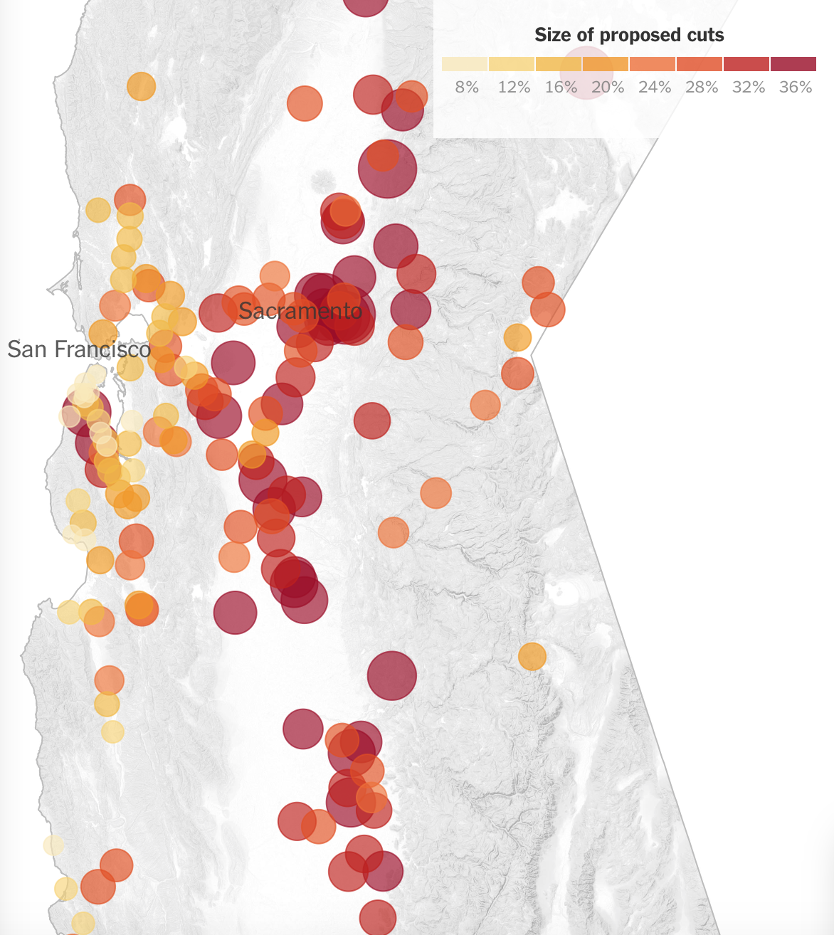
but what might be called the selective yard-drenching in specific regions of the south-lands, according to the same interactive data visualization–

and the notable persistent over-use of water in wealthier areas of LA’s per diem consumption of water this past winter–

The map above offers an approximate reflection of a topography of disposable income, described b UCLA’s California Center for Sustainable Communities. The Center quite recently found not only that “wealthy used more than three times the rate of non-wealthy people,” but wealth was the most conspicuous correlation and predictor of water use–and watering lawns, as we have long known, an increasing sign of conspicuous consumption even in an age of drought.
Is this a decision to spend more on water, or is it, as seems more likely, the conspicuous expenditure of water on yards, perhaps fueled by the cost of letting all that greenspace go dry, or the actual dangers of fire hazards that letting lawns go dry might create? The oft-cited datum that Beverly Hills residents daily “used” some 286 gallons of water during September 2014, at the same time northern and coastal San Diego County consumed some 584 gallons in the Santa Fe Irrigation District, contrast sharply to Compton residents served by the LA Department of Water and Power who restricted themselves to 93 gallons a day and Angelinos in East LA some 48 gallons.
But it bears repeating at a time when Governor Brown wants to mandate across the board 20% reductions in water use as a means of increasing efficiency, if only to ask what some of the best manners of mandating reductions are. By dividing water-usage by census tract, clear patterns in LA County emerge, that make it something of an epicenter, to mix geographic metaphors, with the recent rash of tweets about excessively selfish individual water use at Beverly Hills mansions that include, in some cases, spas and vineyards as well as expansive still-green lawns:

But rather than only call attention to the sociological correlation between water-waste and wealth, this post wants to ask questions about the ethics of the spontaneous sorts of mapping of water-waste that have proliferated in Angelino social media, as if to sharpen critiques of the lack of social responsibility of the wealthy in a city of sharp social divides, in ways that remote sensing is promising new results in a far more detailed manner for select Los Angeles neighborhoods in order to drill more deeply into the extent of watering of lawns, flowers, and trees that underlies such datasets. But human-scale photographs posted on social media via Twitter has been an initial means to assemble immediately available instances of water over-use.
The spontaneous mapping of such inequalities on social-media is a sort of crowd-sourced shaming to redress unspoken social inequities, with offending addresses lain out on twitterfeeds for the public to see, lest anyone be confused about who has the public interest at heart, and who is most concerned with keeping the brown grass at bay, even without looking at the bigger picture, in something approximating collective rage against the overwatered large yard as an exercise of collective shaming, which has gained a real edge given that the state is poised to levy hefty fines on identified water wasters since mid-2014. It’s triggered a geographical awareness of the steep inequities of water use and comes close to socially sanctioned class-consciousness–

–and its effects on the lived landscape ofBeverly Hills lawns:

Such selective outing of levels of outrageously cartoonish disproportionate use of water utilities may run the ethical risk of crowd-sourced surveillance, where aerial photography approaches NSA-style snooping via overhead drones–the regional sustainability manager for Sacramento’s Utilities Department was said to be “pleasantly surprised” at such snitching last summer, when #drougthshaming took off on the Twittersphere. But the current spate of tweeted outrage expressed on social media has also become a venue for expressing suppressed sentiments of a class struggle, very slightly veiling disgust at profligate over-watering lawns indulged by those running automatic sprinklers as if they were draining regional aquifers single-handedly, with little heed for state-wide water shortages, brought to the front in signs posted in public parks that remind users that “Brown is the New Green.”

Tweets are most famous for unleashing wrath against the privileged who are out of touch with the reality of water-needs–

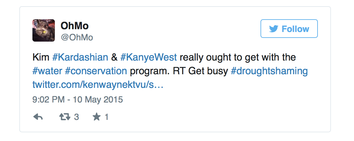
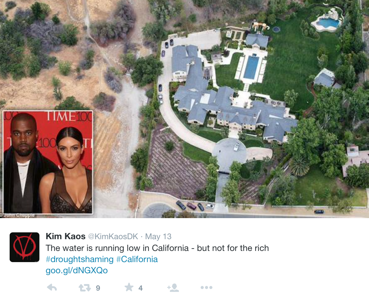
–at the fact that rhythms of daily consumption patterns are so drastically different across a single city by degrees of multipliers. And is it even a surprise that the mansions of three and a half acres we’ve become used to viewing and vicariously living on Reality TV have been most notoriously cautioned by local Municipal Water Districts to cut the their water use drastically? (Both Barbara Streisand and Kim Kardashian have publicly agreed to curtail their water use–“Kim takes this drought seriously;” said a representative; “she has no problem letting her grass go brown.”)
The targeted social criticism is by no means limited to the super-wealthy:

The steep social discrepancies in water-use have thrown into relief the divided economic structures of the city that we’ve long known about from the American Community Survey–Orange County and Palos Verde residents use respectively thee and two times the state-wide per capita daily consumption rates in February 2015–but now suggest that water wastage among the wealthy is actually undermining the public good in a clearly mappable manner. We have long seen larger yards in specific neighborhoods, but watering practices seem to have grown out-of-hand in expropriating the public resource with obliviousness, even while we blame “nature” for a drought that is increasingly evident is indeed largely man-made, and even may as due to human nature as climate change.

During the summer, such deep discrepancies of daily water consumption are of course placed into even further relief in data visualizations of local levels of consumption, reflecting an apparent rationalization of increased water usage as well as the readiness of covering rising water costs, as lower income families responded more rationally to higher water costs.

To be sure, Northern California has done fairly well to reduce consumption from the Spring 2013–

But it is also true that the aerial photographs of the ambient effects of income inequality that sent Google Earth images viral after being posted on persquaremile reveal the grey v. green dichotomy to be by no means limited to the southland–

Such a democratic appropriation of Google Earth may have paved the way for the tweeting of extravagant consumption of water that has become all too evident in some of the larger Beverly Hill yards, that can be linked to specific addresses.
The calls for greater restraint in water usage since March 2013 is far from clear in much of the greater Los Angeles area, as posters on social media have not only realized, but realized that they were able to publicly point out.

Both a more equitable distribution of water access and a rethinking of such deeply-lying assumptions of personal prerogative to wasting water deserve attention as Californians try to curb continued water use in a responsible manner. We will have to tilt swords with some of the deeper espousers of a free market of deregulated water consumption, but at this point, for better or worse, deregulation has its back snugly against the wall.
And despite the reluctance of water utilities to identify wasters of boggling amounts of public water–as the Los Angeles homeowner known only as Wet Prince of Bel Air, a name won for pumping an incredible annual 11.8 million gallons during the recent drought to his estate. The recent news that 100 residents of such wealthy Los Angeles neighborhoods as Westside have been pumping millions of gallons of water apiece has called for more effective means of recourse than twitter revenge, as such outing bears little fruit; in the light of recently passed laws against over-use of water, remote sensing technologies have been used by journalists at Reveal who are eager to even up the score: taking advantage of new fines assessed against excessive water use, the mapping through Digital Globe and others provides a deeper survey of water use than would be released by Los Angeles’ compliant Department of Water & Power. Indeed, the Center for Investigate Reporting has begun to “out” high water-users by remote sensing–and publishing the maps!
Given the limits of Twitter photographs to document public instances of water overuse, the expansive indulgence of overwatering in such somewhat reclusive sites as Bel Air, perhaps inspired by droughtshaming, have used remote sensing provides a means to assess an accurate record of water-use to map the high use of water to estates to out individual culprits of over-watering, tracking the greening of their gardens by Google Earth and Digital Globe and an assessment of exactly how healthy those yards are.
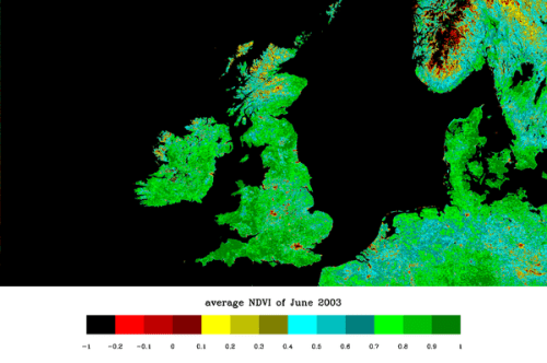
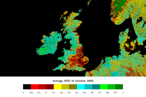
Using remote sensing of the health of plants–by means of a form of remote sensing developed to detect plant health common in agricultural assessment– the Normalized Vegetation Index (NDVI) helps to pinpoint individual culprits of water over-use might be identified whose identity would be otherwise kept hidden by the county, by measuring the living vegetation that has continued its ability to absorb visible light wavelengths of light, the very ones used in photosynthesis, to create a unique dataset of those with the largest living yards in the municipality.
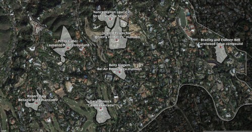
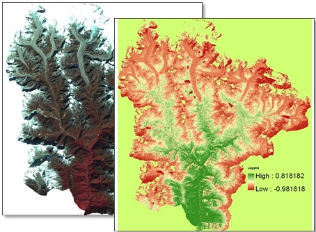
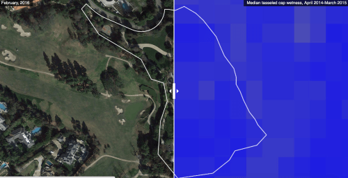
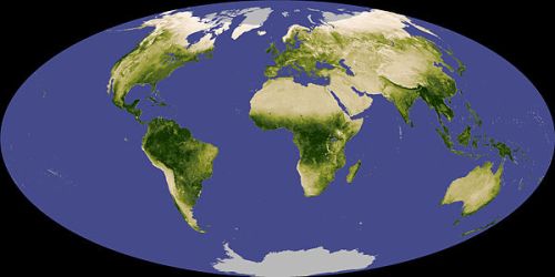
For the primary culprits are be identified by remote sensing of living green vegetation that remain on such sites as the heavily wooded estate that is maintained by move producer Peter Guber, part-owner of the Golden State Warriors, who indulges his wooded estate with over 2.8 million gallons of water each year, while pushing the Warriors to take up a home in San Francisco to boost their revenues. The owner of the 42-room French-style chateau from TV’s “The Beverly Hillbillies,” former Univision CEO Jerrold Perenchio, who uses up to 6.1 million gallons each year to water his plants and gardens. The owner of the 28,000-square-foot “Bellagio House” whose floral gardens suck up over 4.6 million gallons per year. The technology used of combining infrared and near-infrared light by the Normalized Vegetation Index (NDVI). The NDVI has become sufficiently refined from satellite or drone remote observation to parse and better describe water use and its impact in plants with a great precision, as is evident in the MODIS satellite maps of groundwater in the United States, and to present a highly sensitive reading of vegetation health at precise moments in time, and indeed within given parameters of health, by mapping the presence of water in plants–as one would map the presence of water in the ground.
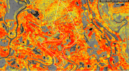
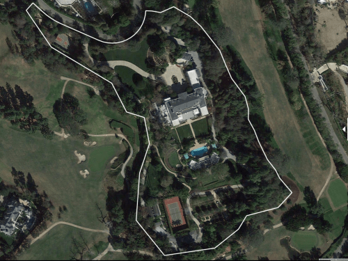
By means of a similar remote sensing with NDVI, one can effectively map lots’ local water saturation at a scale to detect individually owned gardens such as those that Guber indulges on Lausanne Road in Bel Air–outlined below , with relative vegetative health shown in red colors, showing the highest range of the NDVI–as an accurate way to assess the extent of living vegetation, using infrared and near-infrared light to measure the local health of vegetation with amazing sensitivity, much as is familiar from global maps–but is only recently possible at such low scale thanks to Digital Globe–in ways that can not only identify individual culprits of water over-use, but presumably take them to task.
–or the Casa Encantada owned by Garry Winnick–
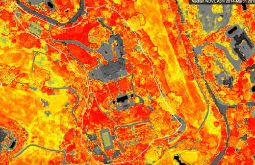
For unlike the yellowed out areas of most of even the region of Bel Air, the bright red expanses suggest an odd over-nourishment of gardens even in a time of drought that indeed seems quite newsworthy, and is perhaps able to be viewed by Digital Globe alone.
–and can also be mapped, if with less clear-cut results, by soil moisture:
While such remote sensing from satellites had been confined to national regions at specific times of year,
–or used to map global differences in plant health–
–the local assessment of those who over-indulge in caring for their lawns and flowers is both something close to surveillance and perhaps a form of surveillance that recent laws about water use have sanctioned in California during our current drought.
The odd triangles and spots of green that remain in a drying out landscape in which most of the rest of us live (spot the non-arboreal light green track in the tan landscape shown below?) reveal the levels of water waste which demand to be curtailed, and are emblematic of the golf courses and overwatered farms that we’ve just begun to take stock.


