Category Archives: geopolitics

Eastward Expansions

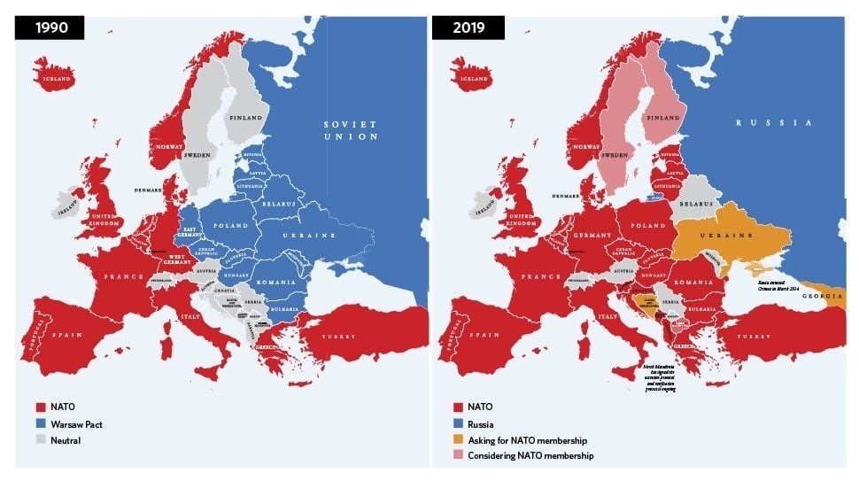
Before a barrage of bombs began to fall on Ukrainian cities from Kyiv to Kharkiv, newspapers of record predicted that “Days of whiplash developments made unmistakable the volatility of a crisis that American officials fear could lead to an assault by one of the world’s most powerful militaries against Ukraine, Europe’s second-biggest country,” as artillery exchanges grew in the Eastern provinces. Fears of Russia staging a unilateral invasion of the nation grew as “a development that Europeans never thought they would see,” alerted the New York Times, challenging if not undermining Europe’s–and NATO’s–expansion of geo-strategic alliances in recent years. But the nominal accusations of an expansion of NATO has blurred, to be sure, with the accusations of the persecution of ethnically Russian populations in eastern Ukraine in the current charges of waging a war of “de-Nazification.” They nationalistic cry rallied faith in a Russian homeland that seem to be a reaction to the processes of globalization against which Putin’s right wing allies–from LePen to Donald Trump–have recently railed against.

If rooted in fears of preserving a lost Russian empire, an ethno-state eroded by the breaking away of Soviets, the recasting of Donetsk and Luhansk as “People’s Republics” in eastern Ukraine hearkens back to the soviet history in which Putin and Co. were molded, a reaction to by military formations in the ear of the Trump Presidency, as pincers around eastern Ukraine, long before the current invasion of Ukraine began–a show of force of tanks, artillery, and rocket systems poised to illustrate the porous nature of any nominal borders when it came to the old Soviet Union. For as if in refusal to let the post-1989 territory emerge as a liberal state–or a separate state–the resurgent ethno-nationalism of “preserving” or “protecting” Russian speakers from allegations of Genocide offered an Orwellian Newspeak by a totalitarian state George Orwell saw as critical tools to rationalize ongoing war, death, and cast as  “subversive” the very concept of free will.

July, 2020/Ukrinform

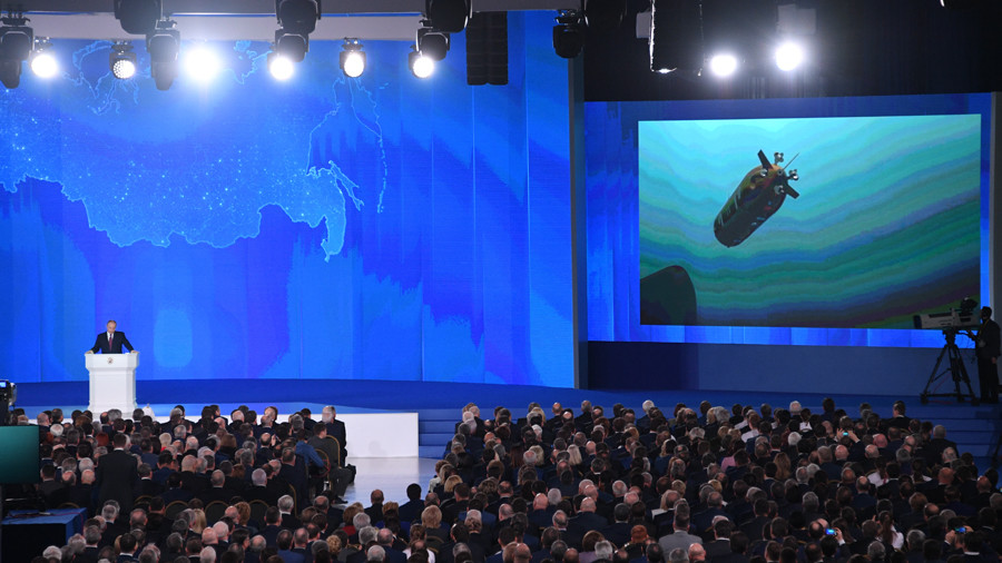
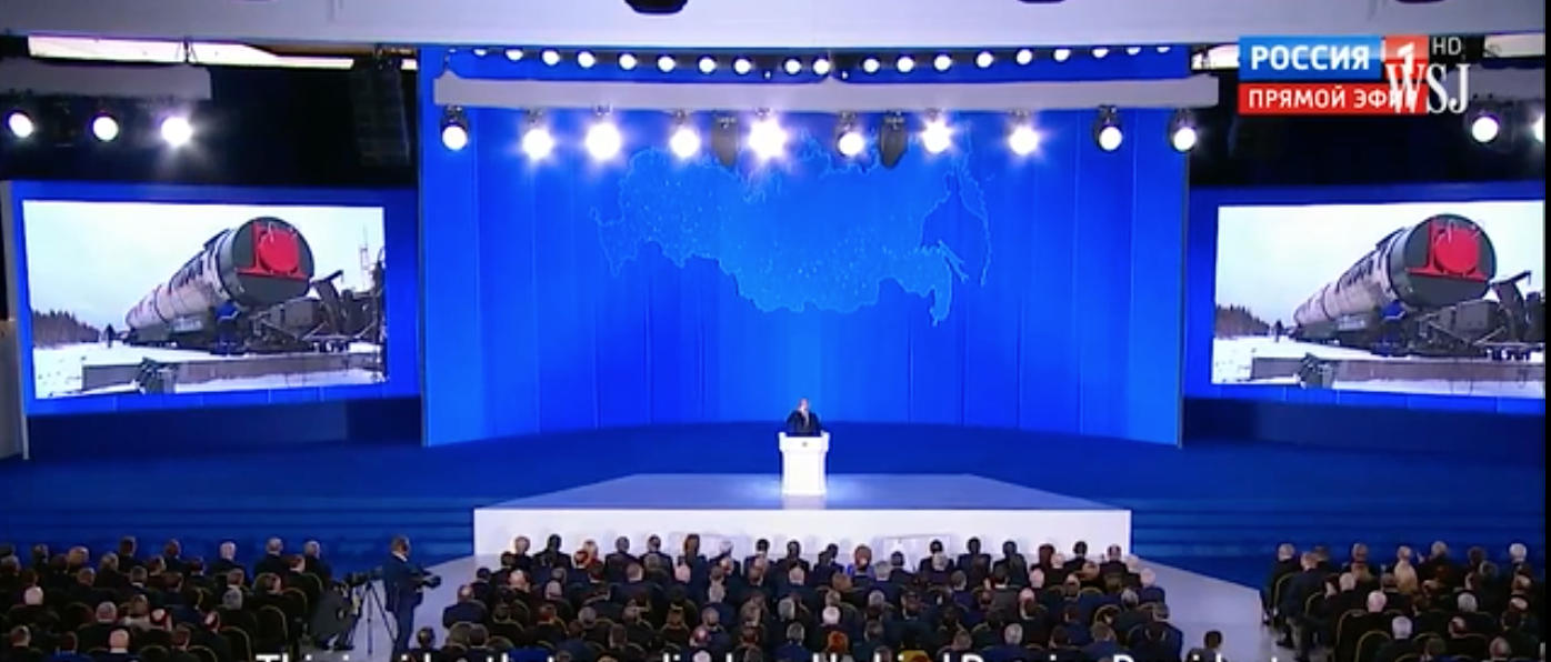
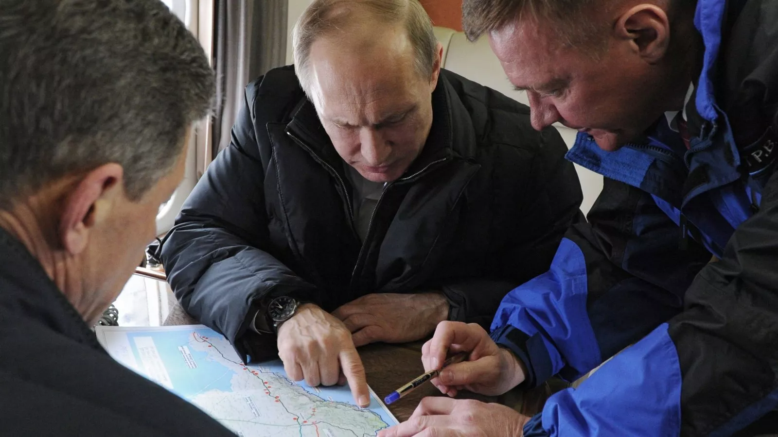
The dramatic massing of Russian soldiers on Ukraine’s border in the Spring of 2022 seems to have been engineered to question that border’s status as a guarantee of sovereignty. As if to mirror but were unlike the erosion of borders in globalism, however, the massing of troops was a display of Great Powers doctrine on the part of Moscow, echoing the emphasis on the expanded range of supersonic bombs that Vladimir Putin had foregrounded in his announcement of the range of nuclear bombs in 2018 when he announced to the world a new arsenal of “invincible” nuclear weapons before a video graphic that imagined warheads hitting the United States. The trumpeting of the apparent invincibility of Russian armaments that Putin suggested in a dramatic tableaux of Russian military dominance–

The bombast was reprised in reduced form at a local level as Russian troops massed an unprecedented show of force on Ukraine’s border in the postwar period. Their congregation seemed to firm up Russian power after Putin had dismayingly, misleadingly and perhaps self-servingly asserted was an existential threat to Russia more than an expansion of a defensive alliance. And if Putin later, after the invasion began, argued with duplicity “What is happening in Ukraine is a tragedy–they just didn’t leave us a choice. There was no choice“–the invasion that sought to reunify the old soviet that had become a breeding ground for liberal reforms was not really about the expansion of NATO, but the consecration of the boundaries of the old USSR, and the absence of “true boundaries” for Russia in the old Soviet bloc.

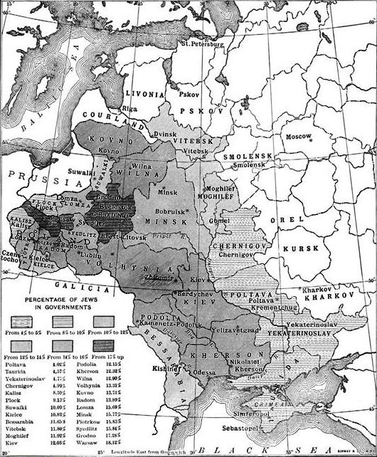
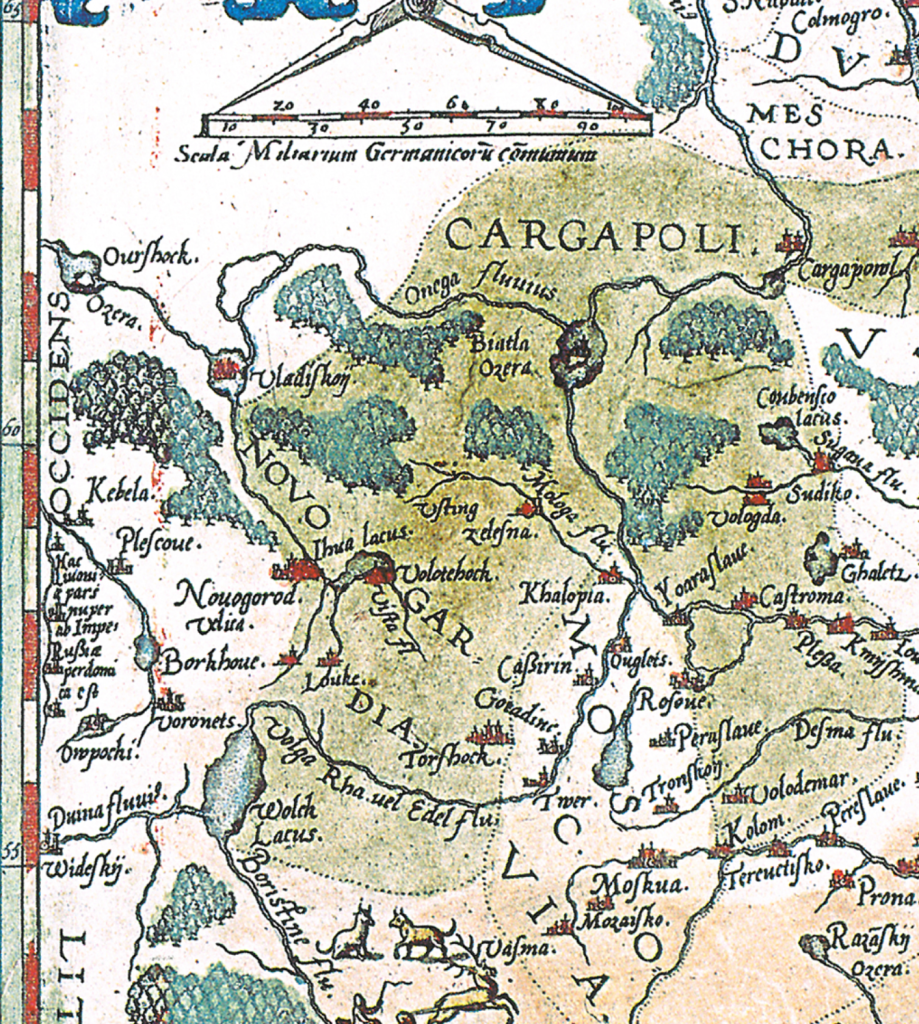
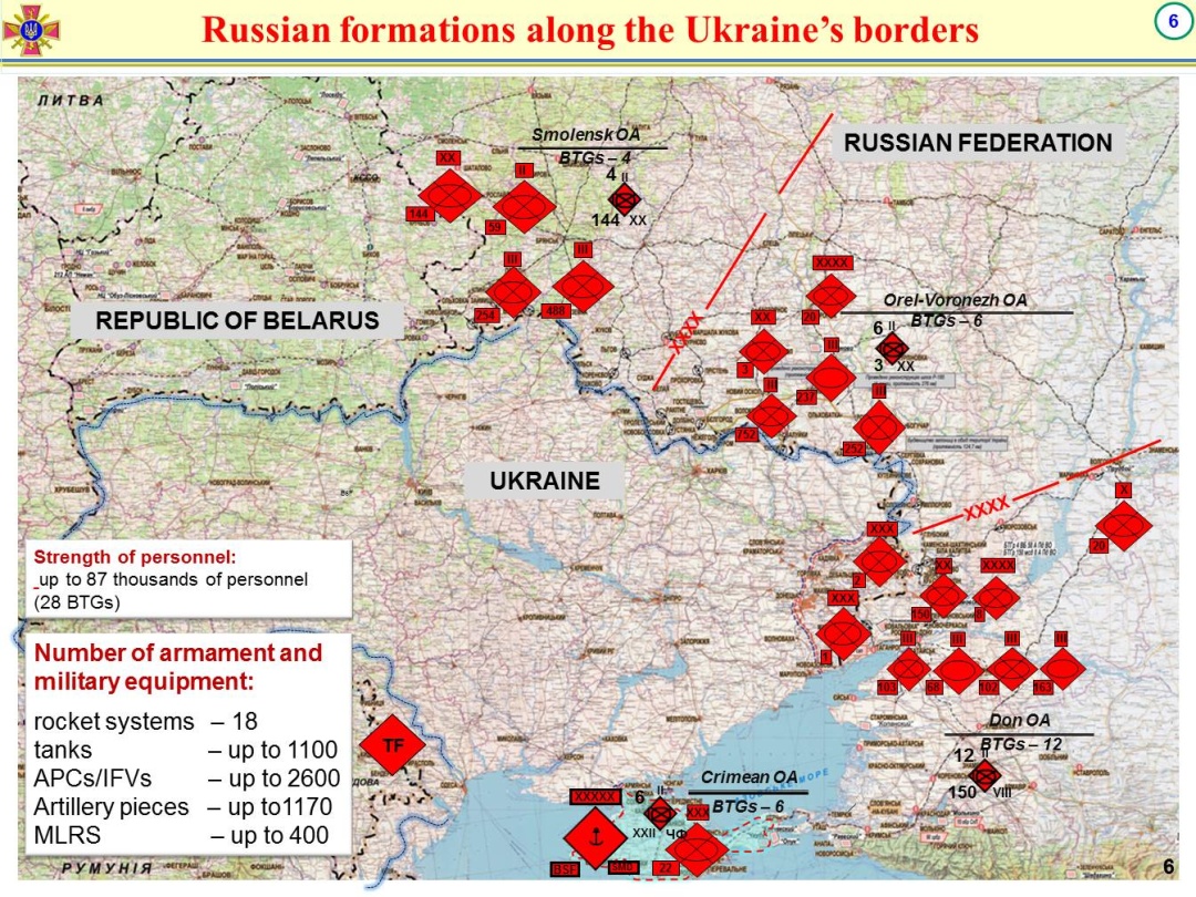
The border was already being denied in the massive show of force that massed in the Republic of Belarus, that old Soviet, in the larges mobilization of troops in postwar Europe. As 90,000 troop joined an assembly of 100,000, equipped with tanks, anti-aircraft guns, fighter jets, and armor on the area where the borders of Russia, Belarus, and Ukraine, the show of force seemed to erase any sovereign border or notion of independent sovereignty. The apparent focus of Ukraine’s forces in the west, was oddly paired with the positioning of Russian troops in the vey same positions they used to confront potential defensive strikes against NATO, as if the missile launchers and military planes by Ukraine’s borders were posed to move against a nation that had been hoping to join NATO, if with some American encouragement, and the readiness to gloss that idea as a tactical aggression that merited an immediate military strike. The fears of a move outside of Russian military and geopolitical influence fed a specter of mobilizing these troops again. This map, from almost a decade ago, suggests the long-standing tenuousness of these borders, and the readiness Moscow had long felt to remove their pretense.

March 1, 2014

The robust show of force that established its theater of influence and refused to be hemmed in by borders of sovereignty. Whether they reflected Vladimir Putin’s beliefs, or, far more likely, offered an excuse for military mobilization of such unprecedented scale against a country with few natural or geostrategic defenses, global media disinformation were filled, at the same time, with the fake news, amplified on Russian news and RT, calling NATO and Ukraine as threats to Russian sovereignty, even as Ukraine’s sovereignty was effectively bracketed and taken off the table, a pretext for Russian escalation whose size recalls imperial wars of the nineteenth century. The refusal of Viktor Orbán of Hungary to let military aid flow to Ukraine through Hungary, a reflection of his nation’s considerable dependence on Russian natural gas, and Budapest’s invitation of for the Moscow-based International Investment Bank, or IIB, whose founding ten member states of 1970 reflected the political geography of the Cold War–was relocated to Budapest in 2019, was long a conduit for Russian intelligence, and is led by the son of a KGB official formerly stationed in Budapest. As Central European states from the Czech Republic to Romania accelerated their exits from in response to the invasion of Ukraine, Orbán threatened Russia’s aggression would overflow far beyond Ukraine and charged opponents had designs to “drag Hungary into this war” and “make Hungary a military target” to his political advantage in a recent electoral campaign.

The vivid reassertion of a Cold War political geography haunts Central Europe today. Aggressive military moves one-upped the seizure of the Crimean peninsula and eastern Ukraine, but the massing of military presence outside Ukraine’s borders ramped up the abilities for invasions that would create a potential impromptu blitzkrieg that would leave, Russia hoped, a stunning memory of Ukraine’s limited sovereignty. Indeed, the clarity with which Volodymyr Zelensky has urgently asked the world to recognize Russia’s hopes to “break our nationhood” is evident in the way Putin’s ally, Belarusian President Lukashenko, addressed the Parliament as a schoolteacher, informing them of the splitting of Ukraine into four theaters of operational command, and several arrows that showed the planned movement of troops into Ukraine,–

Belarusian State Radio

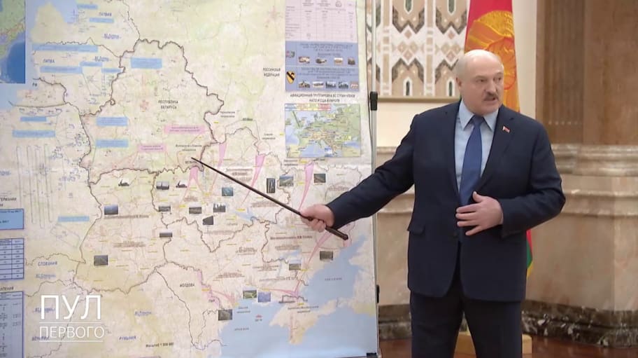
as if the nation that borders Belarus were not really secure, and the plans to use Belarus as a platform for staging an invasion was indeed already underway. The map used as a basis to lecture Parialiament displayed on state television was a “misunderstanding,” authorities claimed, but the pink arrows that staked out the routes by which Russian troops would invade Ukraine already affirmed the absence of Ukraine’s defensible borders; the pointer he used as a school-teacher to describe the impending display of Russian power as if to replace the actual Belarus President-elect, since 2020, Sviatlana Tsikhanouskaya, the former English teacher in Minsk who replaced her husband, Serghey, leader of an opposition Lukashenko had jailed. While Tsikahanouskaya has long left Vilnius, but resists the Russian-based orthography “Svetlana Tikhanovskaya” and Lukhashenko and his security forces relied on Putin for power, Tsikahnouskaya is a government-in-exile who long pinned her hopes to Joe Biden’s victory.

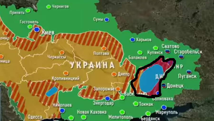
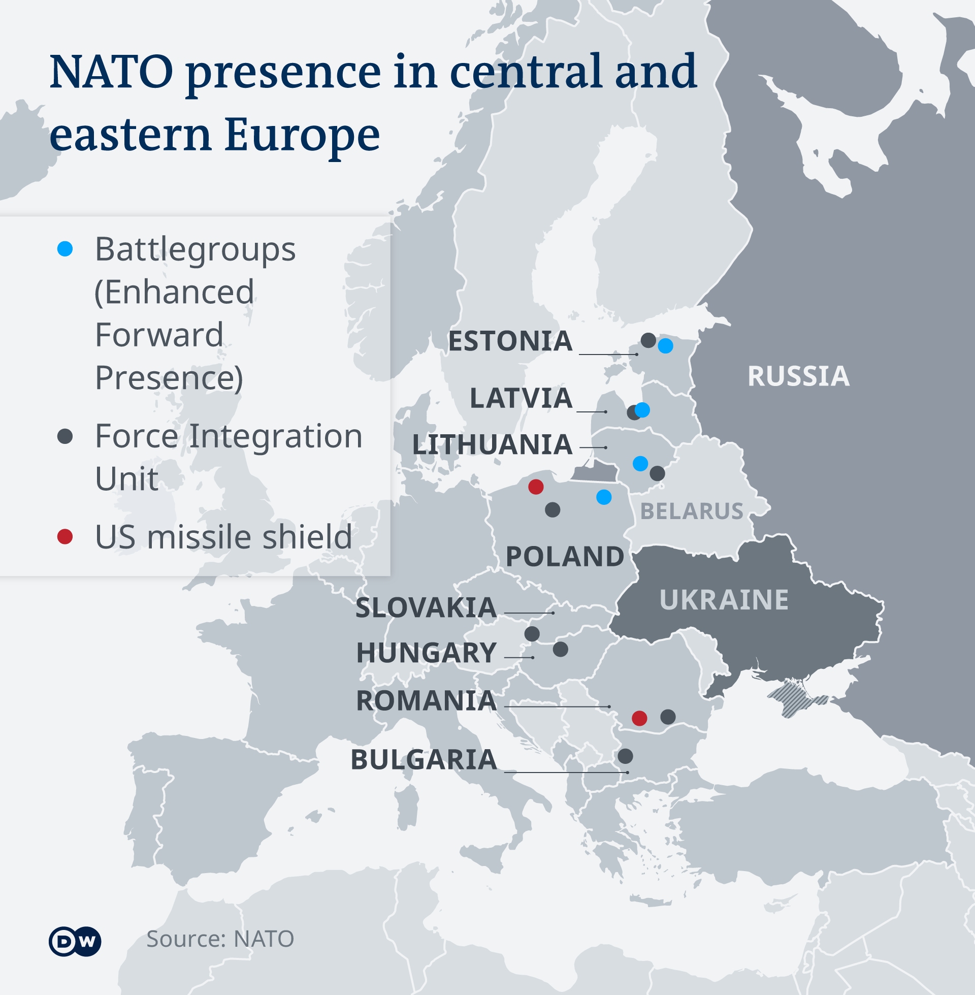
The threat of a cross-border movement of military troops were part of a theater of power and destabilization that had been central to Russian hopes to consolidate an old bloc. Beyond its hopes to affirm its presence in Crimea and around eastern Ukraine, now used as launching pads for an invasion in the above map, beyond countering an expansion of NATO, the hope was to drive fear into the old bloc and gain support from nominally democratically elected allies, from Viktor Orban in Hungary . Russian air force had flown nuclear bombers with missiles of expanded range over Poland’s borders, in November 2021, and in the airspace of Belarus, contesting the ability of NATO forces to move to the east and protecting what it saw as its crucial sovereignty over energy transport to central European states from Hungary to Poland, once part of the old “Soviet bloc.”

As Orbán posed with Hungarian generals and tarred his opposition with trying to drag the nation into war with Russia, Russian television news by March, 2022 remapped a nation in Cyrillic whose eastern half seemed to have collapsed, after Russia taken control of the airspace, with cruise missile strikes on airfields, fuel depots and infrastructure, even if the capitol had not fallen–hoping Ukraine’s inhabitants might decide to accept Russian suzerainty rather than continue war. Perhaps the capture of “territory” in the Russian imaginary that extends through the Dnieper River would provide the symbolic imaginary that Putin seeks to hold, although the ability to “hold” the lands that Russian forces have terrorized and flattened will be steep, even in the steppe lands of Ukraine’s Trans-Dniepr where about a dozen brigades–some 60,000 men–of Ukraine’s best troops are located. The image of Russian control of the Trans-Dnieper symbolically “restored” to Russian suzerainty ethnic Russians, promoting the illiberal logic of an ethno-state reducing Ukraine to a rump and cast Kiev as a border town, wiping Ukraine’s old border off the map.

The result would be to reduce the sovereignty of any Ukrainian “state” to a permeable polygon.

The initial mobilization of increased materiel that the Russian government had invested from hypersonic missiles to potential nuclear torpedos, eager to be installed in the Black sea and stationed in increased proximity to much of Europe, whose energy independence was already steeply compromised by their acquisition of and dependence on Russian oil and gas.

Ukraine became a “red line” to which Russia wanted to gesture, and indeed prominently fix on the map, as visibly as the US-Mexico Border Wall, as the Kremlin repeatedly warned the “red lines” on its maps could not be ignored by any “broadening NATO of infrastructure on Ukrainian territory”–as if the defensive alliance were intended to provide a challenge to Russian sovereign authority.

To be sure, the challenge of Ukraine’s hopes for its own sovereignty were already unprecedentedly threatened by massing from 2020 of military to the east within Russia–

Ukrinform, July, 2020

–far, far beyond the occupation forces that were already located in occupied eastern regions of Ukraine, and which completed a possible pincer operation simultaneously invading Ukraine from multiple borders and sides, as it tacitly pointed fingers at Washington, D.C. for encouraging Ukraine as an upstart by a growing escalation of force.

Russian Presence in occupied Donetsk and Luhansk Oblasts by 1st (Donetsk) and 2nd (Luhansk) Army Corps (AC) 

If Moscow shifted troops to Ukraine’s border to prevent Ukraine from becoming European, or, more accurately, to prevent its development as a democratic liberal state, the demonization of an imagined “expansion” of NATO eastward was imagined as an invasive virus, and a threat to an imagined Great Power status not of Russia, but the Soviet Union, and indeed Russian empire. Yet one can only understand the violence of the massive attacks that were to be unleashed against Ukraine as a last gasp of empire, an in a late imperial rationality of defending the imagined sovereignty across borders, boundaries, and ethnic identity, at a time when Ukraine was a part of the USSR, as much as a satellite states, and “satellite states” were not mapped by GPS satellites but rigid lines and shades of red, whose borders were more nominal than meaningful.

Soviet Satellite States | Schoolshistory.org.uk
Soviet Satellite States

We risk presenting the struggle for Ukrainian independence in the narrative of great powers, however, overlooking the deep threats of the denial of Ukraine’s architecture as a nation-state. The great-power narrative unhelpfully Vladimir Putin as a chess grandmaster whose strategic planning were not thuggish and indecorous land-grabs of illegality. By annexing Crimea, provoking uprisings in the eastern Ukrainian provinces of Donbas–Donetsk and Luzhansk, or carving out a “confederation” made of breakaway “republics” of the evocative name Novorossiya, Putin had made Ukraine less a state than a mythic geography, conjuring it as part of a Greater Russia of Romantic cast. If WInston Churchill suggested with despair that Russia so opaque to be was a riddle, wrapped in mystery, wrapped in an enigma, a belittling metaphor of evoking the Beriozka doll, the alleged anger at Ukraine joining NATO mapped by an imperial imaginary of Russia tied to Ukraine, and to the seat of the historical Kievan Rus’, long sacred to the Orthodox church, wrapped in the historical Warsaw Pact, wrapped in the hopes for a future petrostate, but haunted by the fear of any recognition for a neighboring liberal state and its political autonomy

Putin seemed to have abandoned Novorossiya as a stillborn project by 214, but continued to meet with cronies in Gazprom over maps. We cast Ukraine as a chessboard, not a nation, but the Russian hostility to the NATO membership of Ukraine openly ignores the fear of recognizing Ukraine as an independent state. Ukraine’s reduction to an ethnic battleground in a Cold War geopolitical landscape led the imagined “Union of People’s Republics” to force Ukraine back into a new rebirth of the old USSR where Vladimir Putin was a lieutenant colonel, the “New Russia” foreign to any maps returns Ukraine to a Russian “sphere of influence” more nostalgic than actual, but with its own secure lines of transporting natural gas into the old Eastern bloc, and deep ancestral ties to the old empire whose imaginary remains stubbornly slow to fade. While Russian negotiators told Americans that they didn’t plan to invade Ukraine at all–“There is no reason to fear some sort of escalatory scenario” rebuffed Sergei Ryabkov, Russia’s Deputy Foreign Minister in early January–demands not to allow Ukraine into NATO were an apparent denial of its sovereign status, long before bombs rained indiscriminately on civilians, including hospitals where doctors were forced to heal wounded Russian soldiers at gun point.

And despite

Putin Alexei Miller
Putin and REUTERS/Aleksey Nikoskyi/RIA Novosti/POOL
Lugansk and Donetsk
“Novorossiya,” c. 2014

Despite notoriously low participation in the Crimea’s “referendum” on rejoining Russia–a vote estimated by Russian President’s Human Rights Council, per a leaked report, at a measly 30%–the annexation of the region was accepted, rather than risking open conflict, despite military presence of Russian soldiers in the Crimean peninsula. The deep danger for viewing Russian aims in Ukraine in a “Great Powers” lens grows almost a decade later, imagining the division of Ukraine into sectors that resonate with a Cold War paradigm, is that it ignores the largest fear of a liberal state on Russia’s borders.

Ukraine was compromised as a nation-state, long before its borders were threatened with troops. Divided not by a Civil War so much as by Russia militarily occupying Crimea and significant parts of its east where Russian language remained dominant. The Russian government had recently fast-tracked nearly 800,000 passports, as part of a policy of “passport proliferation” that seemed to have aimed to restore a reduced Warsaw Pact by issuing a slew of some five to ten million passports to the diaspora of Russians from Georgia’s South Ossetia, Moldava’s Transnistria, and Ukraine’s Crimea and Donbas–a sort of “buffer” of peoples that Russia decided it would decree to expand the boundaries of state security, and even military intervention–both to address a growing demographic crisis by 2019, and to cement an ethno-linguistic identity as a regional foreign policy for annexing Crimea and Donbas by 2014–

effectively exploiting the division between “Russian” and Ukrainian language to undermine the hopes of a nation-state. While the intense violence since directed to Ukraine may have no logic, its undermining of Ukraine’s borders is an undermining of a project of sovereign status in favor of the idea of a “Russky Mir,” or a “Russian World” that reassembled a mythic Russian collective that denies the existence of Ukraine as a nation unable to be wracked by civil war.

As the government of Russia has responded to the threat of the expansion of NATO by a policy of increasingly ‘passporting’ former subjects of formerly Soviet territories, time past was folded into time present and the future, and time future projected as present in time past, and all of time eternally present in the invasion of Ukraine, in a historical pastiche of postmodern proportions. T.S. Eliot references aside, the burning of Kyiv and many wonder if Russia’s end was not lying in its historical beginnings, as the fixation on the political identity of Ukraine suggests Putin’s plans to affirm his historical legacy as reversing the dissolution of the Soviet spheres of influence by recuperation of the mythic imaginary of the historically Russian areas of the Kievan Rus’ beyond the early restructuring of Crimea. And if Putin had already commissioned a new global atlas of the world that will adjust the possibly problematic names of cities from Ukrainian to Russian toponymy, so that the resulting product will better rerlect “historical and geographic truth” by ensuring, as he quite aspirationally told the Geographical Society of Russia, and “preserve Russia’s contribution to the study of the sciences and the planet, lest they vanish from the map from the South Pole to Crimea, pushing back on how some nine hundred Ukrainian cities and towns shed previously imposed commemorative place-names since 1990, once honoring Marx, Engles, Lenin, or the leader of Russian Secret Police, Felix Dzerzhinsky, under auspices of Ukraine’s Institute for National Memory, a Gorbachev-era forum dedicated to “decommunization” and reckoning with the Soviet past: 946 towns and cities were slotted for renaming by 2016.

Vladimir Putin Is Redrawing the Map of the World to Reflect How Russia Sees  It
Putin Studied Map of Crimea, 2016

Yet if such linguistic maps are argued to be an explanation of civil strife or sovereign combustability of Ukraine, in ways that justify the intervention of Russia in Ukrainian territory on ethnic grounds, the ethno-national logic of Putin’s justification of meddling in Ukraine’s bounds and sovereignty rests on the deep commitment to “moral values rooted in Christianity and other world religions” that Putin has argued the “Euro-Atlantic states have taken the way which they deny or reject,” linking the Russian Orthodox church to Russian government and moral values, extolling the icon in early modern ways. Even as the Ukrainian Orthodox Church metropolitan Epiphanius I has likened Putin to the Anti-Christ or that the “spirit of the Anti-Christ operates in the leader of Russia,” the invocation of orthodoxy as a basis to justify Russian expansion plays on ethno-nationalist grounds akin to the proliferation of passports to discredit the West in Eastern Europe in ways that have only grown since the possibility of NATO’s expansion eastward: if only in 2018 did the Ukrainian Orthodox Church split from the Patriarchate of Moscow, to which it had remained subservient since 1686, the religious split reveals deep tensions in redrawing the map.

While the European Union had offered the possibility of membership to Ukraine and Georgia back in what seems the other world of 2008, dangling the prospect of “Euro-Atlantic aspirations for membership in NATO” of both states as an opportunity that was on the table. The promise presumed eastward expansion of a North Atlantic Treaty Organization beyond Poland and Hungary, to Baltic states of Estonia, Latvia, Lithuania, as well as Slovakia and Romania able to pick up the peaces of the disbanded Warsaw Pact. Russian reaction to Ukraine the affirmation “these countries will become members of NATO,” was perhaps far less a “whiplash” than the culmination of Putin’s immediate warning of “most serious consequences of European security” would provoked an unprecedented “direct threat” of almost existential terms, that would make Ukraine not a “border” of Russia–it gained its name as a “borderland” of the Kievan Rus’–but, in ways by which Putin seems to have become increasingly haunted, with its own identity as a nation-state.

The concerns of processing the presence of some twenty Russian or Russian-allied military forces around the nation’s border forced us to try to an intractable geographical impasse of Ukraine’s place in Europe, or, as Russia insists, the periphery of Russian sovereignty–if not the sovereignty of the borders of Ukraine. As Ukraine tried to shift its status as a borderland in Cold War maps of old, and the new security structure of a European Union, the world confronted the emergence of a New Cold War, haunted by the division of separate spheres of dominance.

r/MapPorn - NATO members (blue) and warsaw pact members (red) in cold war era
Separate Spheres of Dominance in Cold War Global Map

1. The public perception of an “inflection point” of the eastward expansion of NATO resuscitated a Cold War geography: yet can the fixity of these old spheres of influence fully explain the massing of troops on Ukraine’s borders? To be sure, right-wing American commentariat, obsessed over the dangers of NATO expansion and eager to see American disentanglement from Europe, openly argued that NATO expansion was the precipitating reason for broad military invasion that would kill civilians and destroy hospitals, schools, monasteries, and villages. But the illegality of the invasion that only led Russian state news to recycle Tucker Carlson’s buoyant defense that the Russian invasion is “only protecting its interest and security,” was as popular among Russian government as his asking viewers “how would the United States behave if such a situation [of placing military bases] developed in neighboring Mexico and Canada?”, evoking a Cuban missile crisis playbook of the past. Carlson’s isolationist pro-Putin rhetoric imitates Russian government in subsuming “Ukraine” as a nation in the long memory of spheres of national influence, in which eastward expansion of NATO boded a redrawing of a global map–and ignored the range of missiles, radar systems, and missile interceptors that have already been deployed in the European theater by an expanded NATO since 2019–all exclusively purchased from American contractors and weapons systems manufacturers, long imagined as a “missile shield” over Europe.

NATO-Ballistic-Missile-Defense - Silk Road Briefing
NATO Ballistic Missile Defense System

The demand for “security guarantees” Russia had demanded from Western powers as NATO and the United States since before December has lead, however, to the placement of the Ukraine conflict in a Great Power narrative, as if this were at all informative. Yet the expansion of military defense systems across Central Europe belies the continued finger-wagging of right-wing political scientists like John Mearsheimer long wagged their fingers at NATO expansion in the face of a great power geography.

Germany to send additional troops to Lithuania | News | DW | 07.02.2022
NATO Battlergroups in Eastern and Central Europe, 2022

The Times found Russia’s unprecedented massing of troops along the northern border of Ukraine risked “Reigniting the Cold War Despite its Risks” (January 20, 2022), describing a global power struggle as as if Ukraine’s independent sovereignty was not a crucial puzzle piece in the dilemma. The headline trumpets fears of a new Cold War in Europe, over thirty years after the original Cold War had ceased as the primary lens for geopolitical security, triggered fears of a familiar tinderbox on the borders of Russia, as its leader invoked a narrative of border security and national vulnerability to invade a separate sovereign country. Indeed, the possible rejoining of a Intermediate-Range Nuclear Forces Treaty, which the United States abandoned in 2019, accusing Russia of long violating the terms of a treaty signed thirty years ago, in the Cold War world. If these missiles were long seen as a basis for European security, Intermediate-Range Nuclear Forces, missile deployment is a smokescreen for deep fears of an open democracy.

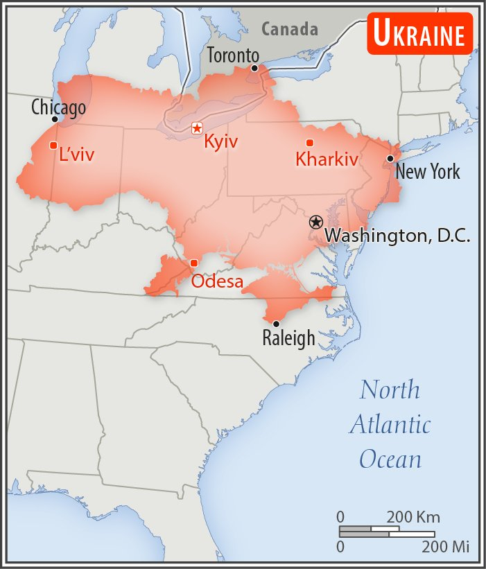
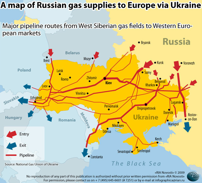
Even if Ukraine, once in the Warsaw Pact, shares a border of over 2,000 km–about the span of the United States’ frontier with Canada on the 49th parallel from Washington to Minnesota, or, alternatively from New York to Chicago. But the border was less the point, or even its length, than the pipelines that allow the petroleum state to reach other members of the old Warsaw Pact, leaving them dependent on Russia for gas.

Image
Brian Taylor

As much as the expansion of NATO, however, the possible of claiming Ukrainian sovereignty of its borders was denied by the troops clustered along Ukraine’s borders who menace crossing into its territory on world view. The massive stationing of Russian and pro-Russian troops on the border seemed something of a performance piece, and something of a threat to end Ukrainian’s European aspirations.

Global conflicts along borders have long been dominating the national news, but all of sudden the edges of borders are up for debate as a debate that contrasts national identity to spheres of influence inherited from the Cold War. The presence of some 190,000 assorted troops of the Russian Federation on or near to Ukraine’s borders is a power play, committed to wrench the region from NATO, if by asserting, as Vladimir Putin has claimed, Ukraine is not in fact a state. Fears of the destabilization of a Cold War geography seem to lie far more deeply rooted in the calculus of Vladimir Putin, who had entered politics after over a decade as a Cold War spook, two years before the declaration.

NATO: Why Russia has a problem with its eastward expansion | Europe | News  and current affairs from around the continent | DW | 23.02.2022

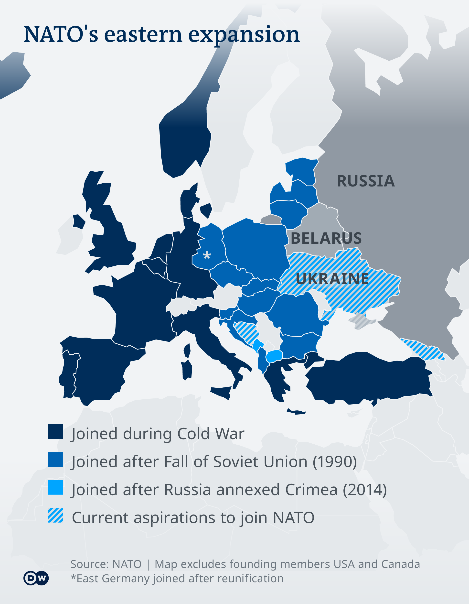
The characterization of Putin the intellectual image of the “chess player” looking at long-term national strategy seemed less in evidence than attachment to the borders of the Cold War bent against the formation of a liberal state. Putin’s preposterous claim that Ukraine was only born as a state as a geostrategic part of the USSR is not only preposterous, but deeply haunted, one might speculate, by a lost geography of the Kievan Rus’, and a sense of preserving the former Soviet Union from the autonomy that its individual states, or soviets, were allowed–and indeed the danger of according such privileges to regions as Georgia and Ukraine, each of which had been offered a partial promise back in 2008 by NATO that they might join the security organization, after Putin had already refused to allow Ukraine to gain such a degree of independence or sovereignty as a state.

The survival of that promise by December 2021 was deeply troubling to Putin as he began to open dialogue with Joe Biden about the military architecture of Europe, and feared the increased unity of Europe and NATO as an alliance. As NATO secretary stressed these plans had not changed, Putin dismissed the “right of every nation to chose its path [and] . . . what kind of security arrangements it wants to be part of” by denying the rights of Ukraine as a nation. And as he claimed Ukraine to be a creation of the USSR, as if it were its property, “entirely created by Russia,” he denied any sovereignty as a state, as if a new Cold War might begin by reassembling the Russian diaspora from an earlier, mythic imaginary, not rooted in a map of nation-states, alliances among states, or national security but indulging a deeper ethnic identity.

Perhaps, in this sense, any paradigm of earlier treaties are not the point, from the Cold War to the Warsaw Pact, even if Putin saw the prospect of NATO membership as an aggressive act that ignored his ultimatum. There may be much in Fiona Hill’s fearsome observation that the maps that Putin is reasoning from are not at all from the Cold War–“I also worry about it in all seriousness,” she confessed, that in the pandemic, as we pondered global biorisks, “Putin’s been down in the archives of the Kremlin during Covid looking through old maps and treaties and all the different borders that Russia has had over the centuries,” obsessing with how the borders of Russia and Europe have changed and how Russia might be reconstituted in Europe, and magnifying the consequences of Russians in Ukraine joining NATO. More than believing Putin intends to wipe Ukraine from the map, it was as a state that “it doesn’t belong on his map of the ‘Russian world'” and its borders or the borders of Europe were provisory on all maps: if NATO seems to think that it can dignify the state’s place in a security structure, Hill sees Putin as denying its sovereignty to affirm the notion of “Novorossiya”–a ‘new Russia’–that in 2014 he imagined as a republic from Odessa to Karkhiv, whose own borders interrupted Ukraine from a map; if the hypothetical confederacy was abandoned by the republics of Luhansk and Donetsk, following high level meetings of the United States and Russia, it had gained an independent flag and conceptual momentum bolstered by the decision of Russia and Bielorussia to withdraw from the International Criminal Court as it considered the criminality of actions of annexing Crimea–as it recognized the “armed conflict between Russia and Crimea” as claiming nearly 10,000 lives since men in military uniforms siezed control of the Crimean parliament, appointed a new prime minister who was a shadowy businessman nicknamed “the Goblin,” as the police-men who have been placed puppet leaders in Donetsk and Luhansk, with less practiced in politics than policing.

INTERACTIVE Ukraine Donbas region Feb
Putin’s Puppet “Republics” of Donetsk and Luhansk

And as the emergence of Donetsk and Luhansk agains as “break-away” republics conjure a map of Russian transnational sovereignty that trumps Ukraine’s sovereign independence is often cast by Moscow as engaged in a “Civil War,” the proposed partitioned gained little traction or public support–and indeed invited such opposition to be classified as terrorist organizations: the mythic republic condemned for undermining any sense of self-determination were again recognized as states by Moscow in February, 2022, precipitating the invasion of Ukraine.

Continue reading

Leave a comment

Filed under Cold War, European security, geopolitics, Mapping Ukraine, Ukraine

Sneak Attacks?

The anniversary of the bombing of Hiroshima gives one pause as it marks the emergence of a world of remote military strikes conducted by GPS, or on a UTM grid that cast agency at a distance from ethics or ethical choice. One thinks not only of the global cartoons of global expanse that seemed to unroll geopolitical spaces for their American readers, but of the new ethics of point-based precision. For the point-based maps created vertiginously elevated the subjectivity of their readers across the 40,000 maps produced between 1941-45 by the U.S. Army Map Service so as to remove most Americans from all sense of a shared ethical framework of humanity as the first atomic bomb was dropped on the city of Hiroshima.

The framing of military invasion as a game of geospatial dominance discounted the massive incalculable loss of human life in campaigns of prolonged fire-bombing and atomic holocaust. While the American military insisted that radiation burns were but “Tokyo tales,” as the government mole in the New York Times, William Laurence, asserted, due to the levels of radioactivity of the Atom Bomb, the cartoon suggested this was but the latest case of action at a distance, asserting a clear causality between the “invasion” of the city in Hawai’i, recently part of Japan, and the drawing and quartering that the explosive man-made catastrophe. The disembodied head miming words of feigned apology invoke a racist stereotype of a hasty apology delivered in pidgin English, disproportionate to the cascading effects it brought.

The oddness of this cartoon rests in its effective displacement of responsibility for the start of the atomic age. Indeed, the narrative this cartoon bears traces of how this new spherical global space suggested suggested a territorial dominance across the new spaces of air travel: the cartoon that appeared after the atom bombs were dropped on Hiroshima and Nagasaki on August 6, 1945 are particularly striking as it appears to remove any sense of the agency of atomic holocaust; it cast the explosive logic of the atom bomb as a delayed quid pro quo response to the “Jap Sneak Attack” of 1941; it asked readers to consider not the effects or impact of the atom bomb, but, rather evasively, who really was “the Fellow who Lighted the Fuse,” as if he were to blame: before any images of the destruction of both cities was described, the Chicago Tribune included testimony of Enola Gay crew members, hailing from Chicago, as an exclusive, with a discussion of the physics of atomic bombs and a reminder that a number of B-29 bombers were posed for further destructive missions.

The front-page color cartoon hid the explosion of the Atom Bomb over Hiroshima, offering an occluded view on a spherical globe: in colorfully eye-catching attractive Hearst style, the colorful cartoon map was the sole visual documentation of the bomb’s effects, masking the devastation of its impact by the geopolitical logic that led to dropping an atom bomb. The only sense of agency in the cartoon is that poor fellow, his head now rising into the sky, severed from his body, as his bloody knife, patriotic flag for the Empire of Japan, and his military boots and gloves were imagined to be blasted far above the globe’s atmosphere. While the cartoon surely registered the global significance of the dropping of the A Bomb over a densely populated city across the Pacific Ocean, the responsibility for doing so was identified with a racialized floating head, finally severed not only from limbs but militaristic flag that suggested a rising sun of Pacific domination, but was now distastefully merged with a stereotype of obsequiousness that belies militancy. Is the beheaded soldier who once wielded a now shattered sword sorry for the catastrophe of the atom bomb?

Carey Orr, “the Fellow Who Lighted the Fuse,” American Newspaper Repository

In fact, he is apologizing, or is forced to apologize, for similar stereotypical sneakiness of earlier attacking Pearl Harbor. The informed American reading the cartoon recognizes as clearly traceable to dropping the atom bomb, by a link as evident as the arcing flightpath by which Boeing B-29 Superfortress the Enola Gay carried the 9,000 pound Little Boy to drop 26,000,000 pounds of high explosives on Japanese civilians.

The spent match that lies on the “big island” of Hawai’i marks the site of where Japanese bombers attacked an extra-territorial military base, at Pearl Harbor. The map serves to help process the devastating precedent of aerial destruction. And it shifts the destructive impact of the bomb, incongruously, to a palette of a sunset just removed from U.S. territory, where the curling fuse that we can only see as running across the Pacific theater leads to a land lying behind global curvature of the earth, that almost occludes the global significance of introducing the atomic age. The bomb is an illustration of the end of the war by the victory of military mapping, and an affirmation of the fact that the only map is global now. But the ethics of that map are more than problematic. It carries a clear sense of “out of sight, out of mind,” imbuing the deaths of over a hundred thousand Japanese civilians–in an odd mirror reflection of the fears of Japanese attacking United States territory–with a sense of victory, painted as the conclusion to the war that Japanese single-handedly begun. The cartoon is a rather concerted shirking of collective responsibility for immediately killing 70,000 Japanese civilians and killing another 50,000 by radiation poisoning created a precedent of instantaneous mass slaughter. It must be paired with the sustained campaign of military disinformation that William “Atomic Bill” Laurence drove, downplayed any destructive effects of the atomic blast’s radiation levels as purely “Japanese propaganda,” as if to conceal its own efforts to portray the role of radiation in contributing to particularly painful and gruesome deaths.

As U.S. President Harry S. Truman would explain to the world that the delivery of the bomb had released nothing less than “the force from which the sun draws its power . . . against those who had brought war to the Far East,” in an impromptu lesson of nuclear physics, the payload of greater power than 20,000 tons of TNT, describing the bomb in empyrean terms that took one’s eyes off the ground as an act of “harnessing of the basic power of the universe” against the Japanese empire that had taken the rising sun as its emblem and flag, as if he was righting the natural order of the universe by using the sun’s awesome power to right the imbalance of a natural order and to deliver destruction in a purely retributive fashion. If almost a quarter of Americans stated after Japan’s surrender that they would have accepted the destructive explosive powers of more bombs earlier in the war, press dispatches claimed that the bombing would not leave any greater medical injuries than conventional bombs; as mortal effects of the absorption of radiation became clear, Lt. General Leslie Groves, having directed the atom bomb program, affirmed the same logic, enjoining reporters who “did not like the way we ended [the war], to remember who started it.” How many times had Lt. Gen. Grove, observing the same map, had arrived at the conclusion after contemplating the range of air routes the bombers would take, as a way of rationalizing the inhumanity of the event by reducing its devastation to the military logic of quid pro quo retribution for military deaths.

Lt. General Groves Observes Map of Air Routes to Japan
A journalist stands on the former site of a movie theater in Hiroshima, Japan, in September 1945, one month after the United States dropped an atomic bomb on the city.
Journalist Surveys Damage of Hiroshima Bomb, September, 1945/Stanley Troutman

Who, indeed, was making the sneak attack? If the yellow and orange hued pyrocumulus clouds caused by atomic blasts suggested the fireball of a nuclear or atomic explosion, the cartoon clearly referenced not only the explosion that left 200,000 estimated dead in its immediate aftermath, but the fireball of the atomic explosion as a sunset of the Japanese Empire. The first dropping of an atomic bomb on civilian population by the United States–

–was sunset of the Japanese empire, seen from the empyrean perspective of the navigation of aeronautical space that allowed its delivery at precise global coordinates. Did newspaper readers who smiled at the grotesque cartoon vicariously delighting in the ability of precise targeting on geospatial coordinates to target two cities for atomic devastation, without considering the humanity of their civilian inhabitants? Or did it prepare the consumption of the news of the delivery of the payload

To be sure Hearst Newspapers had long promoted the Pacific as a theater of national jingoism in which the Hawai’ian islands were exaggerated as a potential site of struggle, frequently distorted as of defensible American interests; Hearst Newspapers Sunday Section of comics portrayed the contest in cartoons of racist tenor, as an antiquated samurai in full ceremonial armor confronted a spry Uncle Sam.

Windsor McKay, 1913

But the explicit use of a spherical projection to accentuate the aerial targeting of sites of bombing in Japan–and indeed of Japanese civilian populations–was both an assertion of the mastery of the maps that aviators followed in releasing Little Boy and Fat Boy, and a sense of the logic of the spherical projection as the conclusion of World War II. Early in the Pacific theater’s military expansion, to be sure, the Japanese Empire had carefully mapped the island in the paper maps that the imperial army drafted for all its soldiers to hold in fold-out versions in elegant form to foreground specific aerial and marine routes to the islands historically inhabited Japanese famers–

–the mountainous outcropping of islands righted by oceanic waters were remapped as the target of aerial bombers attack in 1941 in ways that the atomic bomb was imagined to respond as an analogous incursion into territorial rights. The results were far more terribly destructive, but seen as cementing the territorial retreat of Japanese empire across the Pacific. To be sure, the attack on the United States Naval Base had killed 2,300 Americans in 1941, when Japanese planes attacked the Mighty Seventh Fleet, sinking twelve ships and destroying the U.S.S. Arizona completely destroyed and capsizing the U.S.S. Oklahoma. But the logic of the global map creates a terrifyingly false equality of quid pro quo, or an eye for an eye, in spatial terms, linking the continuity of the spherical projection that enabled the American bombers to target Hiroshima and Nagasaki as a commensurate response to the 1941 Air Raid. The logic of the globe smooths over the disproportionate scale of the atomic bomb’s deadly payload and the attack on U.S. territory for American newspaper readers.

Yet in ways that are perhaps impossible to map, or to take stock of in its full consequences, the atomic fireball left massive human fatalities and injuries in its immediate radius, far beyond the devastation at the site of impact where buildings were flattened, leaving third degree radiation burns far beyond its alleged target, striking civilians both more violently and more deeper within the logic of war than was ever imagined. As if treating the sinking of the U.S.S. Arizona and capsizing of the U.S.S. Oklahoma as attacks on the actual landlocked states in the territorial United States, the treacherous logic of the continuity of the map’s surface created a false equivalence for cartoon readers that recast the dropping of an atomic bomb as a glorious imperial gesture.

The popular newspaper cartoon for the Hearst Sunday daily provided a rationalization of the explosion in maps that provide a continued basis for reflection on the scope of aerial bombardment, departing from the maps of worldly retreat of Japanese Empire on which American newspapers had focussed and were created by late August 1945 by the U.S. Army Information Branch, as if to justify the impact of one devastating attack.

Japanese Empire from 1895 to 19 August, 1945/Army Transportation Corps, Aug. 27 1945
University of North Texas Libraries

Many cartoons of the atomic bomb dropped by the U.S. Army were explicitly racist or misguidedly celebratory. This famous front-pager made open reference, perhaps fitting Chicago, where Rand McNally was based, as the spherical projection enabled dominance of aerial space and mastery of the virtual space of air strikes: the globe was now not inhabited by people, but a spherical surface over which one flew. And while the sign planted on the unidentified island of Oahu is suggested to be the site of the spent match that started it all, omitting that the 1941 aerial attack was staged on a military base–Pearl Harbor–rather than on a civilian population. The colors of the apocalyptic conflagration are muted, as we see only harm coming to the scattered limbs and bloodied knife of a caricature of the Japanese soldier scattered in a stratosphere.

Continue reading

Leave a comment

Filed under atom bomb, atomic age, geopolitics, Hiroshima, Pearl Harbor

The New Cold Warrior in the Triangle of Terror

When addressing the new Latin American policy in Miami’s Freedom Tower in late 2018, the new National Security Advisor John Bolton targeted Nicaragua and Venezuela in a striking geographic metaphor. He offered a new metaphor for described the dangers of a “triangle of terror stretching from Havana to Caracas to Managua,” in November 1, 2018, demonizing Latin America and the island of Cuba in terms that suggested possible plans for “taking direct action against all three regimes to defend the rule of law, liberty and basic human decency in our region.” As if to displace attention from the Northern Triangle from which so many asylum seekers have fled to the United States in recent years, including unaccompanied minors, and where civil society is overwhelmed by drug trafficking, gang violence, and police corruption, the new triangle Bolton seeks to shift attention is a target.

So it may have been no surprise that when attacking the legitimacy of Socialist Nicolás Maduro of Venezuela by imposing expansive sanctions ton Venezuelan oil and gas, Bolton seemed to tip the cards of power. Upping the ante from defining the Socialist regime of Venezuela as an apex in a triangle, in previous saber-rattling that committed the United States to striking a blow at a “triangle of terror” tied to the Socialist heritage of Hugo Chavez and to Raúl Castro, Bolton “appeared to disclose confidential notes written on a yellow pad” to reposition military troops to Venezuela’s border, standing before a global map the divided the globe in no uncertain terms, as if announcing a new configuration of power in his role as National Security Advisor for Donald J. Trump. The “triangle of terror” Bolton warned of in November 2018 seemed to essentialize the fundamentally dangerous notion a Latin American region ripe for instability. But it may have also been sheer coincidence that alliterative force of a rather pointless if powerful polygon was a powerful cartographic conjuring of a strategy of national defense, not located in the Northern Triangle, or the former Triangle of Terror where ISIS cultivated troops, but a new borderless triangle of even allegedly even greater danger–a triangle with a rich political genealogy from the Cold War.

Bolton’s adoption of the rare tired stock term of a triangle seemed to shift attention from the other Triangle of Terror, located when it was most recently in the news on the Afghan-Pakistan border, the very site from which negotiations have been announced to start to withdraw American troops. It may have been sheer coincidence, but Bolton seemed to shift attention from a triangle in the Middle East where American troops had been long stationed and that had been a hide-out of Osama bin Laden and Taliban fighters, as if by the powerful abilities of the friction-free nature of GPS–

–to a triangle that was closer to America’s own sphere of influence from the triangle of Peshawar, Quetta, and Kabul, from which the US was busy extricating itself. Bolton’s November speech was quickly taken, one might remember, as defining the intent of team Trump in relation to focus on a new Axis of Evil, adopting a hard line in Central America as sphere ripe for intervention–“This is not a time to look away. It’s a time to increase pressure, not reduce it,” Bolton announced–and the recent exercise of economic muscle to bolster American refusal to recognize the self-declared electoral victory of Nicolás Maduro, and to declare the legitimacy of Juan Guaidó as President of the nation, demanded a map to concretize the global geopolitical stakes that Bolton and Trump were ready to commit to Venezuela, although the map before with Bolton spoke revealed few of the roots for the focus on this new Triangle, but rooted confrontation with Maduro’s claims to legitimacy in the defense of democratic liberties.

Bolton cast the region as a geopolitical battleground for American interests in stark and rhetorically powerful alliterative terms. He openly opposed the United States to a “Troika of Tyranny”–a term that lexically hinted at a vehicle driven by Russia, but wasn’t the 2016 Presidential election–and almost openly evoked the chills or breezes of a new Cold War, with its division of the world to spheres of recognizing two possible Presidents in Venezuela in ways that expanded an electoral map of one nation to spheres of geopolitical influence–if not alliances–expanding in bizarre terms an electoral map to the world to show that it had global consequences–as if global power dynamics were as simple as an electoral map.

The infographic seems to advertise how much “other countries” had at stake in who was Venezuelan President, keeping mum as to why they did. It helped that Bolton looked the part of an inveterate Cold Warrior. And one could not but recall the openly proprietorial terms of last November, when he announced “Cuban military and intelligence agencies must not disproportionately profit from the United States, its people, its travelers, or its businesses” but pointedly attacked Venezuela by imposing sanctions on its gold, and attacking the “triangle of terror” or “troika of tyranny” perhaps metaphorically tied to a Bermuda Triangle, redolent with weirdly alchemical associations of unknown dangers near islands on the high seas–

–as if one could pretend that the declaration was about the rocky shoals of securing needed democratic reform and less to do with oil revenues and resources, as with the defense of democracy.

The transposition of the polygon of a triangle from Afghanistan to the hemisphere was close to a notion of hemispheric dominance, if it also turned attention from a long war in Afghanistan to a closer, seemingly more surgical, winnable military confrontation. The map affirmed the need for using economic muscle by seizing income from oil as a way to undermined as a Socialist dictator, however, whose socialist government was corrupt and based on cronyism, linked in the global map to authoritarian governments in Turkey, China, Russia, and Iran, and their allies, linking an argument of hemispheric dominance to broad geopolitical warning of the consequences of failing to recognize Guaidó as being Venezuela’s legitimate President in American eyes.

Bolton Declares Sanctions on Venezuela’s national oil and gas company at White House Press Briefing/january 28, 2019
Evan Vucci/AP

Maps often lie, as do infographics: but the international magnification of the lack of legitimacy Bolton had been preparing to declare for some time came not only with trappings of objectivity, but with a not so coded message, that might be the true legend of the global divisions in the infographic, and was the major social media take away: a proposed movement of US troops whose removal from the Syrian and Afghan military theaters was in the process of being negotiated by the Secretary of State: the image, unintentional or not, immediately raised fears and concerns about American military plans and sent a shudder in global media.

While it may have been sheer coincidence that the metaphorical migration of the triangle of terror from one theater of global confrontation to the next was occurring in Bolton’s rhetoric and was mirrored in the imagined frictionless switch in deployment of soldiers in the legal pad Bolton displayed to television cameras–

NSA Advisor Bolton’s Yellow Pad

The mobility of the metaphor and the military seemed to echo the new logic of the Universal Transverse Mercator map, where territorial boundaries and sovereignty have far less prominence than specific sites of dispersed geographic location, and imagined transfers of military power could be a frictionless motion in space.

The infographic provided a sort of parallel world carved up and divided by entrenched political interests but whose alliances helped sovereign boundaries to recede similarly. The global two-color map almost made it difficult to understand that he addressed Venezuela–the topic of his Press Briefing in January, 2019–save by the legend identifying red as “Maduro” and blue as “Guaidó”, elevating each man who had claimed the presidency as holding a global constituency, and dividing the globe to magnifying the geopolitical centrality of the Venezuelan election. In the early February State of the Union, Donald Trump elevated–behind the rubric “Abortion”–the pressing concern of Venezuela immediately after “National Security” and “North Korea,” in ways that similarly monumentalized the question of recognition of the future president of the nation, under the rubric of “never apologize for advancing America’s interest, moved from the Border to “National Security” and withdrawal from the Intermediate-Range Nuclear Forces Treaty, a historic arms control accord of forty years in standing–with the commitment to “outspend and out-innovate” all other nations in weaponry–to North Korea and Venezuela, regions that were almost designated as areas of future combat.

Trump’s pledged to the union in a mid-February address to “stand with the Venezuelan people in their quest for freedom” against unspecified enemies, but targeted dictators tinged with Socialism. The gripping evocation of a struggle against “the brutality of the Maduro regime, whose socialist policies have turned that nation . . . into a state of abject poverty” may have foregrounded the prominence of Trump’s interest in targeting Bernie Sanders and Alexandria Occasion-Cortez as Socialists, in order to taint the Democratic party. But it was also a crisis that recalled how John Bolton, his new National Security Advisor, had conjured a new danger for the United States’ geopolitical position, independently of nuclear disarmament treaties, but which evoked our historical need for intermediate-range missiles to protect domestic interests.

The role of Maduro in Venezuela has been disastrous for its citizens, to be sure, and mismanagement of natural resources by the state demands attention: But much as Trump distorted actual policies by targeting the “Socialist regime” of Venezuela in a speech marked by excessive flag-waving, patriotism, and rally-like chants of “USA, USA,” the prominent place of map before which Bolton spoke distorted the situation, by literally taking our eyes off of the ground. The map obscured the flows of refugees from Venezuela and the humanitarian crisis in South America, as well as access to the vast oil reserves lying beneath the Orinoco River basin’s Belt. The extensive reserves to which America has limited access is mapped by USGS, but was left tacit in the American declaration of sanctions, but motivating an abrupt change in returning attention to the Western hemisphere for the National Security Advisor. And the assumption of Venezuela as OPEC Presidency, as much as the defense of democratic principles, made the clear ties of National Security to the preservation of access to and production from the Orinoco Reserves–shown below by PDVSA–and the truly globalized investment in the fields shown below, estimated to include three hundred billion barrels of bitumen–the black, viscous, organic “sludge” that contains petroleum–in what are estimated to be the largest reserve on earth, involving multiple international players–from Statoil of Norway to ExxonMobil to Chevron to BP, but also CNPC of China and TOTAL of France, as well as even if the private ownership in the Orinoco Belt was ended in 2007 by Hugo Chávez, whose Presidency haunts the current crisis. But although nationalized in name, the project of oil extraction are only majority owned by he vast majority of bitumen remains too deeply buried for surface mining–some 88-92%–by Petróleos de Venezuela (PDVSA)–creating a site that was used by Chávez to finance social reforms and projects, and created revenues of $30 billion annually in 2011, making Venezuela a sort of bit of an economic bubble in a globalized world, tied to international markets for carbon and oil, and making Venezuela a “hidden” global petroleum power, estimated to have hundreds of billions of barrels of oil.

Petróleos de Venezuela (PDVSA)

The international ties to projects of extracting bitumen and refining oil in Venezuela–which produced about 2 millions of barrels a day in 2015–estimated to have far more technologically accessible reserves. The decision to amplify the level of rhetoric used to isolate Maduro and acknowledge Guaidó as President surely has close ties to the assumption of increasing attempts of national oil and gas company to reroute its oil supplies to Europe and Asia, as members of the Maduro regime told the Russian news agency Sputnik, not only responded to the sanctions, but undercut the Venezuelan crude that usually flowed to CITGO refineries in Texas, Louisiana, New Jersey, and Illinois which made access to crude that lay in Venezuelan territory a national security question–as Oil Minister Eulogio del Pino tweeted hopes to “continue consolidating strategic alliances between PDVSA and Rosneft” in November, disturbing images of hemispheric dominance, as well as undermining American energy security.

.

USGS has estimated 513 billion barrels lying in the Orinoco Oil Belt, without determining or publishing the proportion technologically or economically able to be extracted
Venezuela Oil Holdings – Deep Resource
CITGO’s Petroleum Terminals in USA/CITGO

Bolton’s–and Trump’s–description of Venezuela as an ideological struggle is all one sees in the two-color division of the globe that almost heralded hopes for a return to a Cold War where maps were understood primarily as a global battleground, recalling the days at which a vertiginous sense of power in postwar Europe led us to map exchanges of nuclear missiles, and imagine apocalyptic scenarios where the world was divided by global war–but a global war that seemed to really be about American interests on access to energy reserves, hiding behind the scrim of a ratcheted up rhetoric of democratic legitimacy.

The economic crisis in Venezuela is both tragic, and an acute crisis of humanitarian scope. But the global map seemed to reduce it into a global confrontation of two blocks, if not a crisis of global consensus about representation and political legitimacy, that seemed to hollow out the term of democracy of its content: despite national sovereign division in South American, the sharp divisions of the blue of North America and most South and Central American nations described inexistent international blocks of consensus. What seemed a legitimate record of global divisions about the crisis the legitimacy of the Venezuelan government to lay claims to Venezuela’s rich reserves of oil. Without acknowledging the political or economic actualities in the South American nation, the map hinted at a global crisis, its stark red v. blue color-scheme reflecting the offers of Russia to restructure the debt of Venezuela’s oil and gas companies, and China to lay claim to a stake in Venezuela’s oil, by asserting the reserves to lie within America’s hemispheric interests, and equating those interests as lying with America’s National Security.

As if to bolster Guaidó’s claim that he is backed by the democracies of the world–in ways that nothing better than an infogram can attest–

Just 25% of the world’s governments have publically recognised Guaido as President; the remainder recognise Maduro’s election
(Paul Dobson / Infogram.com/February 6, 2019

The map before which Bolton spoke has become a topic of recurrent interest, as the nature of the global divide has been parsed and examined. The divide, this post argues, was less an informative one–deisgned to generate debate–than to paper over the situation in Venezuela’s political crisis as a question of alternative candidates for President, treating the contest as an election, and using the colors of an electoral map to suggest that the election was conclusive, and the legitimacy of Guaidó reseted on clearly ideological foundations.

Bolton spoke at the White House briefing before a map revealing a broad global divide ostensibly about recognizing Maduro’s legitimacy as Venezuela’s President but that hauntingly recalled the geopolitical divide that was firmer than many since the Cold War. It provided an image of the Cold War as it was seen from Washington, in some way, as if ideological divides that are clearcut still maintain legitimacy in a globalized world. The infographic on two screens seemed to affirm the broad global consensus of questions of the legitimacy of Maduro’s government, as if this justified the decision to block access to all property located in the United States of the national oil and natural gas company, Petróleos de Venezuela, S.A. (PDVSA), place its assets in escrow, and prohibit American citizens from paying the company directly for access to unrefined or refined oil assets. But the “press briefing” was also a transformation of the White House into a new newsroom of sorts, that exposed the illegitimacy of the Maduro government through a map that tied the United States to the defense of democratic principles–coded in blue, with other democratic allies, in opposition to “reds” linked to Socialism or Communism–China, and Russia, even if it was not Soviet, but also some questionable allies–that reinstated the for-us or against-us global space to make a point. The disclosure before this map of a threat of sensitive statement that echoed a bespectacled Bolton’s assertion that “all options are on the table” provided a powerful infographic that tied Washington to an image of legitimacy, even if the awfully crude map lacked legitimacy to orient American viewers to global affairs.

The new global imaginary that Bolton promoted as he stood beside U.S. Treasury Secretary Steven Mnuchin painted a global schism as the consequence of Maduro’s declaration of his victory in a second term as President, as a violation of that nation’s constitution–and as standing in violation of the Venezuela’s constitutional elections–but was as much a response to the defense of a restatement of American economic sovereignty in the Western hemisphere, a phrase going back to the turn of the last century, if not the Monroe Doctrine, but which gained new currency in the Cold War as issuing from the Dept. of State, and as a question of national security rather foreign affairs, by tactically magnifying the geostrategic role of the Venezuelan election, rather than offering evidence of a constitutional argument about sovereign legitimacy. The question of sovereignty seemed intentionally blurred, as the Secretary of the U.S. Treasury took questions about sanctions against a foreign state-owned oil company, currently OPEC chair, whose assets were being frozen to promote democratic legitimacy, but in fact to strengthen America’s hemispheric dominance.

This time, the map–whose stark divisions into blue and red blocks suggested a map of American alliances, echoing an imaginary of detente, rather than legal rights–seemed to place the defense of denying the flow of economic goods from American territory as a globalist argument, by reframng the issue of constitutional rights or legality in globalist terms that preserved an image of American dominance within the color scheme that it divided the world.

And National Security Advisor John Bolton, who in less than a year in the Trump administration has become an advocate for military interventions in both Iraq and Iran, used the briefing before a map to raise rather openly the possibility of a military resolution of the crisis over the Venezuelan Presidency, as the Commander of US Southern Command, General Mark Stammer, is set to meet the Ministry of Defense of Venezuela’s neighbor Colombia, and Maduro has conjured fears of a “coup” driven from the United States. But the fear that the invitation of American oil companies to organize the refining and extraction of Venezuela’s abundant crude reserves after the January 23, 1958 Democratic uprising, just before the Cuban revolution, sent shock waves into the United States, pushing the Trump administration rather precipitously into a search for infographics that could substantiate dangers of infringement of its hemispheric interests and geopolitical dominance, and to convince the world of the danger of Maduro’s disenfranchisement of elected members of the Congress, and the lack of legitimacy of a regional vote that supported Maduro’s government against a fractured opposition–and led to the invitation from Russia to restructure the state-owned oil and gas company’s massive debt, recasting the struggle about the government’s legitimacy into new global terms.

The colors on the global map reflect, to be sure, the contested results of elections in Venezuela, where compromised elections had produced the heavily disputed endorsement of Maduro’s Presidency just last May. After an offer from Russia to restructure the massive national debt in November, 2017, Maduro declared new elections in May 2018, which the opposition decided not to recognize, and which polls suggested he wouldn’t win, but in which he was victorious–coincidentally at the same time thatJohn Bolton gains the portfolio as director of the Trump NSA.

October, 2017 AP/A. Cubillos
2017 Regional Elections of State Governors in Argentina
Distribution of votes for Maduro in the election whose low turnout led its legitimacy to be quickly questioned by the EU, US, and OAS

Familiar blue v. red electoral maps were used to describe the votes of the Great Patriotic Pole and opposition  Coalition for Democratic Unity that were recast suddenly in global terms in late January in Washington. Socialist Maduro affirmed independence in his inauguration, and in rebuke Parliamentary President Guaidó won immediate support from Donald Trump after he declared himself Interim President and leader of the nation and of oil company, precipitating a powerful infographic to be devised in Washington that oriented audiences to an electoral map in global terms. But for Trump–and for Bolton, who cast the election as a question of National Security–the global divisions in globally strategic terms.

Trump’s segue in his February 7 State of the Union from the INF to Venezuela, included a transition about North Korea, but suggested global imbalances that any obscure the question of access to petroleum reserves in Venezuela, and the deep, implicit question of whether the American military should or would be used to guarantee access to Venezuelan oil. In ways that must have crossed Bolton’s radar, but have faded from most public comments, Maduro when he pledged to decouple the pricing of Venezuelan crude from the dollar, use of non-dollar currencies as the Chinese Yen for Venezuelan oil, and seeking to cut oil production to “stabilize” oil prices–and entertaining the cryptocurrency Petro, based on the five billion barrels of oil found in Field No. 1 of the Orinoco Oil Belt–possibly less than a quarter of Veneuela’s considerable total oil and gas reserves, whose accessibility to the American economy has suddenly become increasingly tenuous.

PDVSA

The events tied to the assumption of the Presidency of OPEC led to ‘slow coup’ of January 23–the anniversary of the overthrow of the Jiminez dictatorship by Venezuelans in 1958–as opposition politico Juan Guaido auto-invested himself with the presidency with broad American support, followed by a chorus of right-wing governments in Latin America, including Brazil’s Jair Bolsonaro.

The result was to pretend that the elections which the opposition party had boycotted last May could be cast again as an electoral map, this time not involving Venezuelan votes–or the self-determination of the nation–but symbolically recasting the election in terms of a global map. Even as Maduro offered to negotiate, he bristled “The presidential elections in Venezuela took place, and if the imperialists want new elections, let them wait until 2025,” perhaps reacting to the provocative recasting of the national elections, whose legitimacy has been questioned by observers, in ways that led Bolton to take to Twitter to threaten “serious consequences for those who attempt to subvert democracy and harm Guaidó”–as if he were the victor of an election. Bolton had escalated attacks on the “legitimacy” of Maduro from mid-January and the “illegitimate claims to power” of the Venezuelan “dictator” as abrogating the “a government duly elected by the Venezuelan people” and democratic practice. But the stark divide of the global map seemed to resist any discussion of negotiations and affirm the United States’ ability to shift troops from Afghanistan to Venezuela’s border immanently–while preserving something of the illusion that the “blue” votes for Guaidó would be affirmed by American muscle.

Win McNamee/Getty Images, off CBC

The gruff determination and stoniness that registers in Bolton’s face as he sought to communicate the divisions of the world that potentially lay in the failure to affirm America’s recognition of Guaidó bled far beyond the defense of democratic principles, and seems to have threatened to cast more than a shadow over Europe. Bolton’s slightly veiled message of national security seemed, in classic America First style, to cast a shadow over European allies, here symbolized by the actual shadow that his pensive head cast on the United States’ traditional NATO allies.

Was Bolton in the act of forging global divisions of a new Cold War, military detente and hemispheric dominance, sneakingly if all too familiarly tied to defense and affirmation of democratic principles?

Continue reading

Leave a comment

Filed under geopolitics, latin America, national security, news graphics, Venezuela

Russian Blues

The projected map was a subliminal reminder of the stakes of the speech Vladimir Putin delivered to the Federal Assembly.

For all its modern appearance, the glowing map of the Russian Federation that recalling a backlit screen, seemed an updating  of Soviet-style theatricality and state spectacles.  As if in a new theater of state, the map of a magnified Russia seemed to cascade over a series of scrims that framed Putin’s head during the annual State of the Nation address, which he had moved to weeks before he stood for reelection to a fourth term from its traditional date.  Putin was projected to win the election, but projecting the map under which he stood identified him as a spokesman for Russia, and identified his plans with the future of Russia–


Map crisper curved


–and allowed him to present a “State of the Nation” that projected the future global dominance he foresaw of Russia within the world, and allowed him to present an argument of protecting the boundaries of Russia, and the Russian Federation, even in an era when boundaries and the mapping of boundary lines are not only contested but increasingly without clear meaning.  Putin’s involvement in aggressive actions beyond the borders of the Russian Federation–whether in the American elections, as all but certain, if of unclear scope; the invasion of Crimea and Ukraine; or in the elections of Brexit and Hungary, or poisoning of Russians in other countries, all distracted national bounds.  But all were presented, in a cartographic sleight of hand, as a vision of Russia as a state of the twenty-first century.  If our current maps no longer follow the “jigsaw puzzle” of the map that the icon of the luminescent map recalled, and the global reach of Russia’s missiles that he claimed could not be intercepted.


Russian Missiles


Remapping the Russian Federation was the central take-away from Putin’s speech to the Duma–even while allowing that “we have many problems in Russia” with twenty million Russians living below the poverty line, described the need to “transform infrastructure” and claimed that Russia faced a significant turning point in its history, which would alter its relation to space.  Indeed, the argument that Russia “had caught up” with the mapping systems that were used by the American military since the 2003 Iraq War–one of the first international conflicts that Putin had encountered as President of the Russian Federation–and suggested the lack of clear limits to frontiers, or anti-missile rockets to the global scope of a new generation of nuclear-power Russian ICBM’s.  A statement of the resurgence of Russia–and a renewed defense of the foreign policy of the Russian Federation–all but erased or whitewashed Russian military presence in Georgia, Ukraine, and Crimea, presenting the arrival of Russia on a global stage through an awesome holographic map.

The map offered something of a “warrant” or guarantee of the arrival of the Russian Federation on a global stage, and provided viewers a reassuring image of Russia’s prominence on the global map, despite the fairly dire state of domestic affairs and the limited plans for expanding national employment or social welfare.  The value of the map, mesmerizing in its illustration of the entirety of the Russian Federation, provided an illustration of foreign policy and argument of expanded powers of global intervention, by which Putin, former head of state security, sought to suggest its arrival as a ‘strong state’ despite the historical challenges and setbacks of earlier regimes, and what Putin has long seen as “the greatest geopolitical catastrophe of the century,” the break-up of the Soviet Union.  The map met the need to bolster Russian self-esteem, and indeed identifying esteem with the territorial protection of “Russian rights,” irrespective of the boundaries that were drawn or existed on other maps.  For while erasing Russian intervention in Chechnya, Georgia, Crimea, Kyrgyzstan, and Ukraine, the map sought to project an image of the consolidation of Russian abilities for “global governance” as an extension of Russian sovereignty.

It is striking that the map was a reflection of the manner in which Putin had long understood or seen the invasion of Iraq in 2003 as an extension of American claims to sovereignty, in violation of international law, and the new image he wanted to create of Russia’s similar abilities to ignore national boundaries and boundary lines.


Putin weapon launch
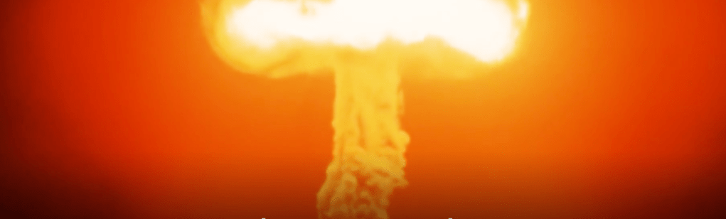
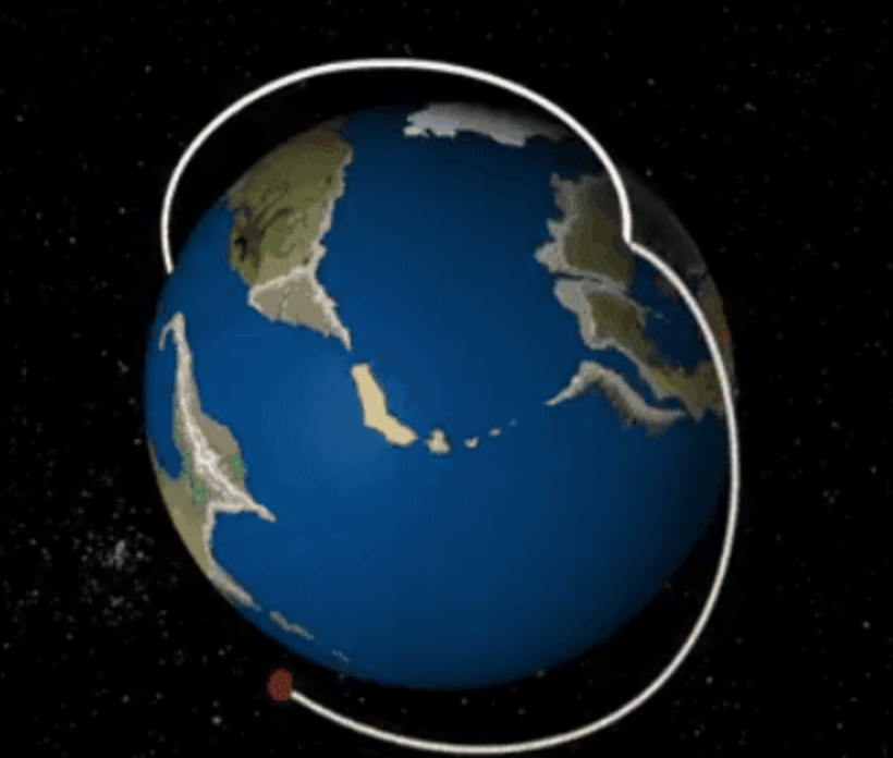
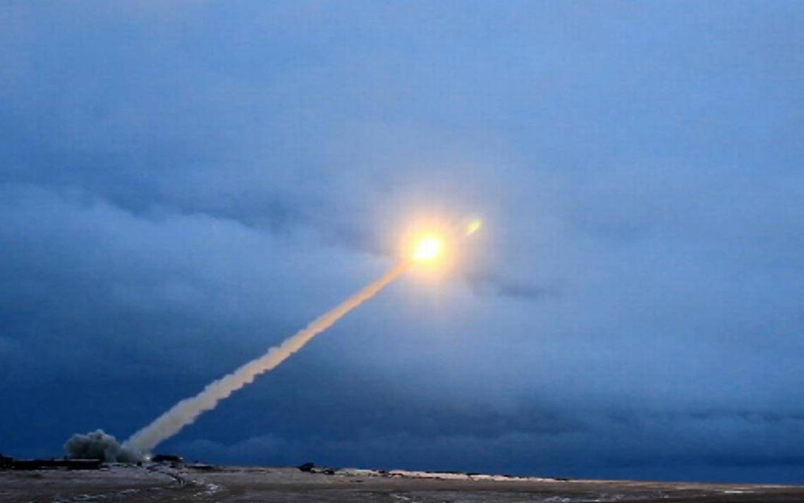
Video grab from RU-RTR Russian television (via AP), Thursday, March 1, 2018, allegedly portraying Russia’s firing of a nuclear-powered intercontinental missile

The map affirmed the arrival of a new consensus in the Russian states and ethnic republics–members of which were assembled before him–to recognize the arrival of a new role that Russia could occupy and would occupy in the global map.  Indeed, the made-for-television map of the Russian Federation suggested the new relation between local and global–and of Russian sovereignty and international abilities for “global governance” that would be guaranteed by an expanded arsenal of nuclear weapons, in ways that demonstrated the expansive reach of Putin’s Russia far beyond its boundaries, in ways that would upstage the American use of GPS in the Iraq War, and the precedent that that war set, in Putin’s mind, for flouting international law in the assertion of American sovereignty–despite the multiple logical problems that were avoided in making such a claim.  But it seems that much as George W. Bush’s headstrong rhetoric of fighting “terrorism” was adopted wholesale by Putin in subsequent violations of the sovereign rights of Ukraine, Crimea, or Syria–and the justifications for defense of Russian interests as the same as sovereign grounds.
made for TV maps.png
The broadcasting of Russia’s possession of a new generation of intercontinental ballistic missiles, unable to be intercepted, as well as designed to frighten the United States or a feign to enter into an arms race, were presented as the basis for illustrating the lack of Russia’s need to respect any cartographic lines or continental divides.

1.  The pre-election State of the Union address, as if a continuation of the diatribe Putin launched against the West for “trying to remake the whole world” unilaterally and in accord with its own interests, provided a broadside of the determination of Russia to defend its own interests, rather than seeking through military invasion or moving of its troops across borders to “reinstate some sort of empire.”  But his discussion of how “turning points” in history determined the foundation of cities in Russia and its relation to “space” seem on the point–and a bit of pointed positioning in regard to Russia’s future positioning on a geopolitical map.

As if to respond to the ion, Putin focussed most theatrically on its development of “invincible missiles” and nuclear-powered arms as defensive weapons in a two-hour address before a packed hall that was punctuated by repeated ovations and applause.  He  omitted any mention of Russian presence abroad, but focussed attention on the Russian nation as able to protect its allies adequately and preserve its place in a “rapidly changing” world where some states were bound to decay if they did not keep up with the pace of change.  As an almost entirely male audience uneasily awaited Putin, turning in their seats, greeting each other, staring ahead stonily or smirking and nervously straightening blue ties.  All faced the glowing blue map projected above an empty stage in the new venue, as if into their minds, as if in preparation for how Putin would remind them of the problems of charting Russia’s future course, even as they may have been most satisfied with the unprecedented foreign influence Putin had achieved in much of Europe, Hungary, England, and the United States.  When Putin took stage with triumphal music, describing how the “significance of our choices, and the significance of every step we take . . . [will] define the future of our country for decades,” and a new time for Russia to “develop new cities and conquer space” after maintaining the unity of the federated nation and its stability in the face of great social and economic difficulties but still faces the danger of “undermining [its] sovereignty.”


Map crisper curved


Projected onto multiple scrims, the glowing image of the Russian Federation lit by glowing centers of population echoed Putin’s discussion of stability, and the need to affirm the “self-fulfillment” of all Russians and their welfare through new economic policies, which he assured them had nothing to do with the upcoming elections, but cautioned that the failure to create technological changes would lead to potential erosion of its sovereignty despite its huge potential.

The glowing national map dominated the room overwhelmingly in which the three-term President spoke, describing the as he aimed to win an election to continue his Presidency through 2024, and convince all Russians of his leadership of the nation.  Below the map, unsmiling, Putin solemnly addressed the nation as if he were its architect and the protector of its bounds; indeed, the projection of the fixed bounds of the Russian Federation onto a set of screens behind him seemed to celebrate its continued power vitality after three terms of Putin’s presidency, even as he recited fairly grim statistics about the state of the national economy.  Describing the need to enhance its civil society and democratic traditions, Putin raised the prospect of once again “lagging behind” other nations, its body politic undermined by a chronic disease, and define Russia’s future, if its modernization was not affirmed in the face of .  The continued coherence of the nation reminded viewers that, notwithstanding threats of dissolution after the fall of the Soviet Union two decades ago, and a reduced GDP and natural resources, the Russian state was back.

The map of Russia was projected in isolation from the world, but the image that resembled a back-lit glowing screen became a basis for projecting the power Russia had regained on a global stage.  Rather than imitating the graphics of a paper map, the iridescent blues, splotched with centers of population, called attention to the permanence of the Russian Federation’s borders and affirmed its new place in the world.  The bounds of Russia were protected, the triumphalist image implied, but the place of Russia on the world stage was implicitly affirmed even if it was shown in isolation:  rather than showing people, or including any place-names, the map magnified the idea of Russia, and its futuristic projection suggested the continued power of Putin to transport the nation to modernity, its boundaries protected and affirmed and its defense of allies acknowledged.  While Putin had recently accused the United States of triumphalism, insisting that Russia was indeed “self-sufficient” and denying Russia was “encroaching on its neighbors” as “groundless,” he seems to have relished a new triumphalism, and famously continued to present the invincible military weapons Russia had developed–lasers, ICBM’s, which, nuclear torpedoes, and nuclear-powered cruise missiles–which, while not revealed “for obvious reasons” would definitively displaced the United States from a position of global power and could penetrate US Defense Systems with ease..


Video in State of Union address.png

Continue reading

1 Comment

Filed under geopolitics, globalism, nuclear strikes, Russia, Russian Federation

The Earth of Nvogorod

Nvogorod [is] the village where my grandparents were from in Belarus,” Jared Kushner clarified on the eight page of 11-page of testimony he provided to the U.S. Senate, intending to reference Novgorod, off the Volga, but not following Belarusian geography or Kushner family history.  when he sat down with the head of the Russian state investment bank that had funded many state projects, to “help advance the President’s foreign policy goals” in a half-hour meeting perhaps designed to open the secret back-channel between the incoming Trump administration with the Kremlin many suspected both Trump and Putin had desired. Gorkov is a banker, but had studied in the arm of the intelligence agency of the Soviet Union, like Putin, and was suspected to have been a trusted agent to Putin–as well as to be seeking to address the sanctions that were imposed on the bank since the invasion of Ukraine. Gorkov said meeting with foreign companies–not governments!–was “normal practice” for an officer of Vnesheconombank, without mentioning the Ukraine, but he hoped to talk to Kushner as a businessman, stressing a business angle outside diplomatic contacts between foreign ministers; his ties to security services made him precisely the sort of individual entrusted for delicate tasks of a personalized government, as it had led Putin to appoint him to run a state bank tasked with financially funding many of his own personal pet projects.

The sort of kinship that the donation of earth Gorkov carried to New York seemed a way to forge a human tie to Kushner, and to suggest something like an odd token of fealty–although it does not seem that Kushner got it. But the sense of a tie to the earth akin to the ties that Russia had long claimed to Ukraine, seemed an odd sort of argument about the ties to land the Russian government felt to the area of the Crimea in Ukraine, and the pro-Russian separatist factions in Ukraine that Moscow has supported since 2014, and Putin hoped that Trump would recognize as a part of Russian territory. If Kushner sought to minimize the stakes of the half-hour meeting by describing the exchange of trinkets and tokens like a bag of dirt, the gift symbolized questions of territoriality and Russian rights to Crimea–to personalize a territorial conflict that led the European Union to target Russian energy, defense, and finance sectors, but which insider ties to Kushner–and Trump’s White House–might help smooth.

Tattered Ukraine Flag Planted in Contested Earth

It is no surprise Russia wanted to shift from a topic of international debate to an internal issue of administering domestic affairs, asserting irredentist ties to the region settled by Peter the Great, by securing a personal and confidential contact to Trump’s team before it assumed government power.

So why the dirt from Novgorod on the heels of the 2016 election? It seemed a personal touch, if one that Kushner didn’t get, and that Gorkov seemed to have aimed fairly low as a way to present a token of opening a personal tie to the son-in-law Trump clearly trusted. Perhaps the most amazing aspect of the gift is how openly Kushner didn’t get it–and the land of Crimea that Gorkhov probably wanted to personalize as a part of Russian lands Putin had only sought to restore to his country in a rightful manner might conceal the 1.6 million internally displaced that the aggression into Ukraine had produced, and the conservative estimate of over 10,000 civilian and military casualties, and almost 24,000 injured, as it entered its fourth year.

In concealing the personalization of a major foreign policy initiative, by dismissing the presentation of a “bag of dirt” Kushner may have foregrounded the highly personal nature of the back-channel of foreign policy–the meeting was set up by the Russian Ambassador Sergey Kislyak, who had ties to several members of the Trump administration in waiting. Donald J. Trump administration has continued to pressure Russia over its involvement eastern Ukraine. Although the United States, soon after Trump’s inauguration, in fact imposed new sanctions that Russian called tantamount to a “trade war” on nine companies and twenty-one individuals tied to Russia’s occupation and annexation of Eastern Ukraine, engineered by Rex Tillerson and Kurt Volker, Special Representative for Ukraine Negotiations, and approve sales of anti-tank weapons to Ukraine in 2018, Gorkhov seemed eager to open a personal contact with Kushner between businessmen, parallel to American national interests. Was the bag of earth and art from “Nvogorod”

Might Jared Kushner have mis-remembered his ties to a Russian region where Charles, his father, regularly took the kids–suggesting that it was Novgorod? The bag of dirt might seem a link that Putin or Gorkhov wanted to consolidate, and probably brought from Belarus, but the suggestion of the strength of regional ties to a region in Russia’s sphere of influence, who also hoped to develop close ties to the United States. It arrived beside “a piece of art from Nvogorod, the village where my grandparents were from in Belarus,” although the ideas of this being a tie of affectionate remembrance is contrived. Oddly, displacement, death, and invasions would have been told in the dirt that Gorkhov sought to present to Kushner, could well have evoked the city from which Kushner’s grandparents were in fact refugees, albeit because they had fought as partisans in Belorussia against Nazi invaders–now the nation of Belarus. In describing an ancient Russian city, long part of Lithuania, that was residence for many Jews, Kushner revealed his hazy purchase on a site dear to his father Charles, whose parents had once been members of the city’s large Jewish community from the Pale of Settlement, where Jews were granted permanent residency in a region imagined fenced off and enclosed, as if to be the site where Jews had long lived apart–a point of memory not dear to Kushner, where Jews had made up a large part of the overall population, and had been a large group of partisans, but faced anti-semitism.

But Jared oddly used the term associated with Novgorod Land, near Moscow, where, one suspects, the dirt he had been brought by the Russian banker Sergey Gorkov, personally appointed to run Vnesheconobank (VEB), the foreign bank of the Russian Federation by Vladimir Putin, had derived–a region close to Moscow, where Kushner’s father-in-law had famous ties.

Novgorod Land in Duchy of Moscow (1593)

Kushner’s admission to receiving a ceremonial “bag of dirt” from Gorkov not only played down its ceremonial status quite adroitly–“he gave me two gifts–one was a piece of art from Nvgorod, the village where my grandparents were from in Belarus, and the other was a bag of dirt from that same village”--seemed a token that this grandson of immigrants thought to be innocuous, but in underscoring its incidental nature. But the city in the Pale of Settlement where Kushner’s family hailed was from from the bucolic land of prancing reindeer mapped in 1593, he betrayed his deep sense of ethics in claiming that bag as his own, and may have called attention to the somewhat conspiratorial gesture the head of the VEB, revealing ties of a broader sphere of Russian influence the bank had Combe to embody.

Kushner’s orthodox religion is public record, and a matter of considerable pride.  But Kushner cloaked that ethnic identity and whatever significance his family might have assigned the dirt–and whatever Gorkov thought he was doing carrying the earth to New York City–a bit too smoothly.  The conspiratorial nature of the gift seemed symbolic, but the associations that the earth seemed spiritually impregnated were deprecated in odd ways in Kushner’s haste to play down the meeting’s significance as an exchange of family trinkets. Kushner’s grandparents had fled the walled Litvak ghetto of Nowogródek months after it was established in June, 1941, in Belarus, joining a fierce Jewish partisan resistance in as Nazi troops extended the Jewish genocide into Russian lands. As the Nazis ghettoized Jews and extended policies of extermination in the city near Minsk, the Kushner elders joined a Jewish partisan squad in the Belarus–escaping the ghetto via a tunnel of over two hundred yards dug over weeks by his grandmother Rae, then seventeen, with her brother Chonom, by hand-made instruments, successfully tunneling underneath electric fencing surrounding the ghetto walls, and helping some 350 Jewish men and women fled the ghetto to nearby forests where many lived for a surprising stretch of time, often in underground bunkers: would the groups trained in Zionist Youth Groups in the Pale of Settlement think of themselves as Russian? Or was this the history Gorkov tried to conjure, to forge a tie to Trump’s son-in-law?  

Continue reading

2 Comments

Filed under Belarus, Cold War, geopolitics, Vnesheconombank, World War II

Mapping the New Isolationism: America First?

The tortured narrative of the recent American election ended with something of a surprise.  As we struggle to map their results, it is impossible to deny that they may mark entrance into a new world which may antiquate earlier forms and points of geopolitical reference, as global politics seem to be about to be destabilized in ways we have never seen.  For in ways that reconfigure geopolitics which transcend national bounds, the extent of destabilization seems to abandon the very criteria by which we have been most familiar to map national borders, and indeed  international relationships, as we enter into a new era of resistance, suspicion, and fear that dispense with international conventions that seemed established in the recent past–and internationalism rebuffed and international obligations and accords dissolved.  Or at least, this was one of the few promises made by Donald Trump that appealed to voters that seems as if it will be acted upon.

The very America First doctrine that catapulted Trump to the White House stands, for all its championing of national self-interest, to be best embodied by the removal of the United States from its role on the global geopolitical map.  And the removal of the United States and England–achieved through the striking success of go-it-alone political parties in both nations–seems to show just how outdated a five-color map is to describe the world.


cattelanferrari


The vintage Rand McNally map that claims to provide a world picture assigns prominence to the United States–and Great Britain–becomes the perfect foil and field to illustrate the impending uncertainty of a move against globalization across the western world.

For the prestige of the globe as an image for the dynamics of global politics was long familiar as a part of the furniture of the Oval Office, as the stunning fifty inch diameter mounted globe that OSS director William J. Donovan had specially constructed for President Roosevelt, at the suggestion of General George C. Marshall.  A stunning pair of monumental mounted globes were presented President Roosevelt and Prime Minister Winston Churchill by the U.S. Army as Christmas Gifts in December, 1941, which set on large bases on which they rotated for easy consultation.  The globe embodied the newly emergent geopolitical order that folks as Donovan created and served, and which the OSS Map Division protected.  Could we imagine Donald Trump gazing with as much interest or cool at a revolving globe?  While Roosevelt stares with remove but interest at the globe, apparently focussing his eyes near the Straits of Gibraltar, this formerly classified Central Intelligence Agency photography was meant to celebrate his growing mastery over a theater of global war.


Roosevelt before GLobe in Office.pngRoosevelt and OSS Globe in Oval Office/Central Intelligence Agency


The monumental “President’s” globes Donovan presented on Christmas 1942 to both Franklin Delano Roosevelt and the British Prime Minister Winston Churchill placed monumental revolving globes–each weighing an unprecedented 740 pounds–occurred at the suggestion of Dwight Eisenhower, with the confidence of “that they foreshadow great victories,” in the words of George C. Marshall, and Roosevelt proudly told the General that he treasured the gift enough to place it directly behind his chair in the Oval Office and to marvel at the ease with which “I can swing around and measure distances to my great satisfaction;” Churchill’s was sent by airplane directly to 10 Downing Street.

The symbolic role of these large and weighty globes cannot be overstated:  the large globes symbolize the complete mastery of geopolitical knowledge by both commander in chiefs in the midst of World War II; they show the investment of military forces in maps.  The world map served in the post-war to embody the new global order already emerging during that war on which both understood a benevolent geopolitics destined to define American hegemony in the post-war; the Weber Costello globe company of Chicago, Illinois would construct some fifteen copies before going out of business in 1955.  With sixty years of hindsight after the globe-making company shuttered its production line of deluxe maps, it seems the new United States President has opted to withdraw attention from maps.

Continue reading

Leave a comment

Filed under 2016 US Presidential Election, Art and Cartography, Brexit, geopolitics, globalization