Monthly Archives: September 2013

Savoir Your Terroir

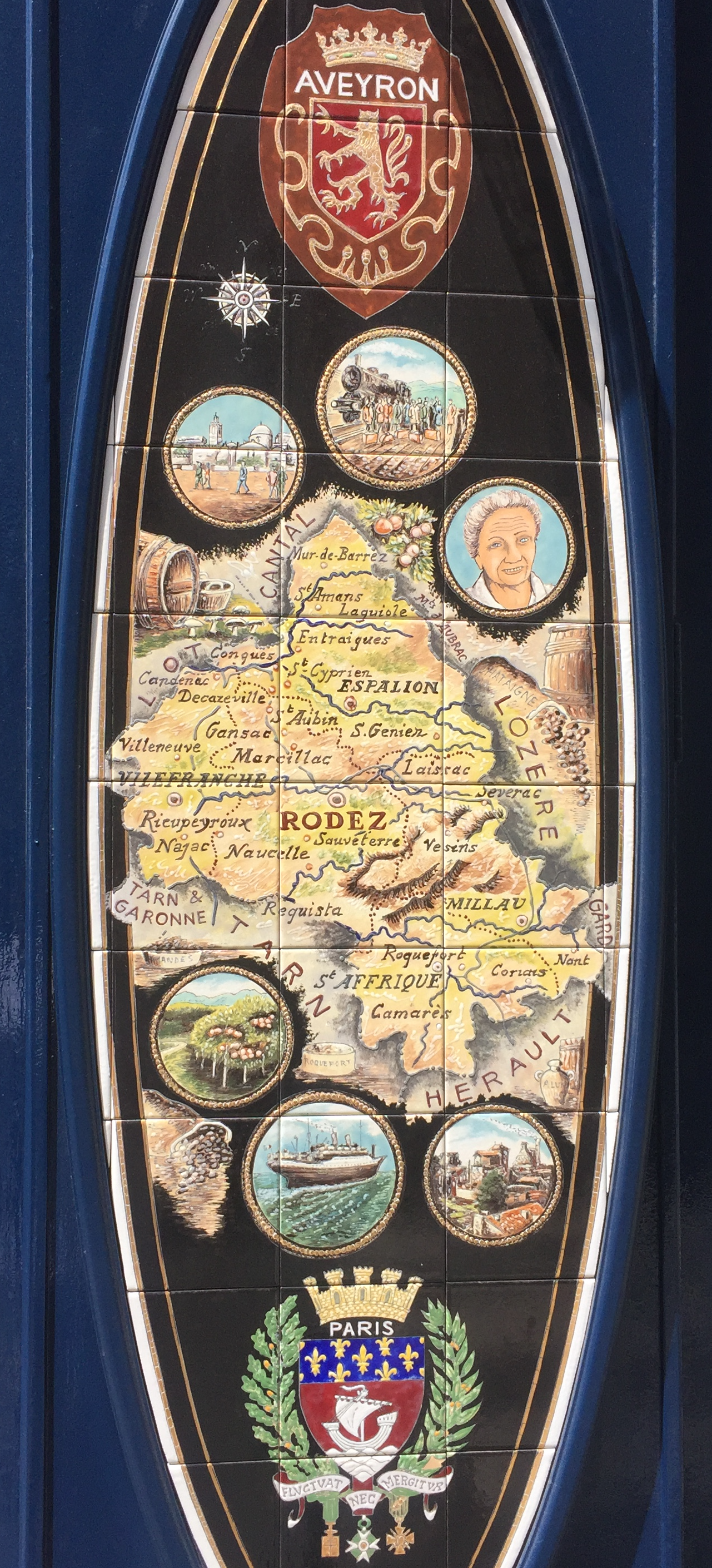
How to spatialize the taste of wine is perhaps less important than the legal grounds of defining who has a right to produce wines of a given name.  But the wine map has become a genre in its own right to link the sensory experience of wine-tasting with the geography of place.  Especially in an increasingly homogenized spatial landscape, the preservation of place and locality–denominations or appelations–that guarantee the specificity of wine-quality by not only a legally defined and protected classification of geographical indication, but a preserve a sense of the landscape as defined for wine-growing. While the notion of a “terroir” is not exclusively dedicated to wine by any mens in France–one might speak as well of the “quality of the terroir” of cheeses, meats, or other local foods, assimilating them to the earthiness of the map–

–and indeed of any region, showing the produce as indigenous to the quality of the earth, tied to each region of France, as if the earth had produced the produce of the region without human help–a sense that was enouraged by the individually embodied depiction of each region as the Fons et Origo of its produce, people, and crest.

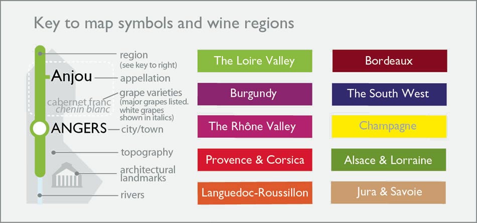
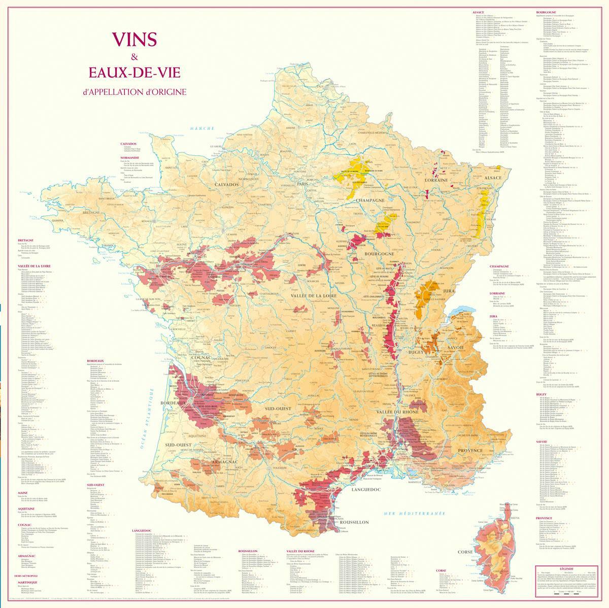
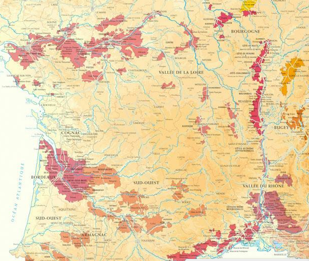
–the definition of “terroir” has been appropriated and adopted by California wind-growers to define their place within a geography of enological status in recent years. In an age of globalization and web-based maps, the artisanal notions of cartographic authorship are mined to the max in hand-styled maps of the regions of wines, foods, and and cheeses, or of traditional knives, that proliferate in the mapminded culture of France. Even the authoritative maps of the Loire Valley meld their scientificity with the sophistication of the appelations of burgundies, as the name of France is itself almost less legible, or on just too grand a scale, for the readers of the varietals of the Loire Valley, or Val de Loire, a region that assumes primacy as a center of visual attention, exploration, and savoring that seems designed to translate to the palate, as much as eye.

The recent imagery of the California’s wine productions using in barrels and clusters of grapes in an old tourist poster of the state for San Francisco’s Wine Advisory Board in ways that beckoned visitors to rural areas of the state, distanced in their symbology from AAA maps of the region’s roads and even from motor travel, but seemed to transport one to a land of barrel-rolling and wine-sipping that recast the state in predominantly rural terms where wine-growing occurred exclusively in a set bucolic regions removed from urban life. Indeed, the transformation of Napa region to a “wine country” that is removed from the city and industry–even if San Francisco is hardly a City of Industry–

–but rather one of relaxation, an alternative world to discover that lies close at hand, and indeed that beckons. The tacky directional orientations in such pictorial wine maps from regions as the Napa Valley suggest the arrival in a bucolic space, free from cares, where the presence of instrumentation is absent from the natural nature of tools of directional orientation, in a region of the world where the very surface of the map is besotted with grape juice or wine.

While selectively omitting any sense of urban settlement or indeed automotive conveyances, the Wine Advisory Board seems to have been designed to seduce visitors by the cartographical vignettes of relaxing workers and relaxed banjo-playing, in ways that naturalize the wine-growing as part of the landscape in order to boost local wines an era when California reds were often cast as the poorer cousin of fancier French wines.  To make the point that the state was so nourished by the year-round sun to be the land of wine-growing, oak barrels are plentiful from Santa Clara up past Mendocino, in an alternate tourist map that suggested how wines themselves transported one to the vineyards of the California countryside.  There was a time when the bounty of wine harvests in Northern California led the region to be cast as a site blessed by vineyards and grape harvest, where the light of the sun distinguished the Napa and Solano Valleys or the grapes of Sonoma as winemaking towns in a predominantly rural idiom.

WINES, Napa Valley to Fresno.png

But more than any other impression, one can sense by the map’s vintage that oenology is not, in the American West, at this time a refined science, so much as an almost rustic pursuit, destined for tourists and removed from the pressures of urban life:  much as the wines are themselves able to transport one to an idyllic rural setting, removed from race, class, work, and urban congestion, to a landscape in which one might leisurely repose.   Little sense of knowledge about wines seems important.

But the times have changed, as they often do, and the rise of the Napa regions are in the course of placing themselves on the map, as if to update the criteria for rustic travel and enological tourism, to respond to how California wines are appearing a global market for wines, and to place the region on the map in a way that it once never was. The precision of classifying terroir has migrated to northern California, and done so to secure California’s place on a global wine market, to authoritatively define its place in relation to the scientific standards of wine that are used world-wide to ensure in vino veritas, or at least identify with security the provenance of the wine as a basis for its quality. The objective authority that maps bestow on products is a novelty in northern California, but the scientificity of mapping, chemical analysis and secure ranking have become terms of economic validation.

1.  For in California, the notion of terroir is absent.  Indeed, the precision or authority of the claims of individual growing regions of viticulture that has become so important in recent years was long completely absent.  The division of such divides reflect–and have common origins with–the proliferation of descriptors that are usually blamed on Robert Parker, who enriched the descriptive language of wine-drinking with terms as acidity, astringency, jamminess, balance, and oakiness who also bequeathed the notion of “intellectually satisfying” wines to underscore the discriminating judgement involved in tasting good wines that so effectively remapped wine-drinking as a learned intellectual experience to bring it out of the rural land in which much California wine-growing was long symbolically enshrined.

Claiming his place at the avant-garde of bucking this trend in cartographical symbology,  northern California-based oenophile David Gijsen recently returned to the mapping of northern California vineyards and varietals in recent years.  Gissen followed the recent trends in mapping mass transit when he decided to remap his adventures in wine-tasting to distinguish his adventures in wine-tasting in the region, and cleverly adopted an image familiar from public transit to suggest how California wine-tasting has become a new mass-experience, tied to how we experience the wine-growing regions of the state.  Rather than employ the agrarian images of bountiful vineyards, his symbology shifted the metaphorical rooting of a wine’s terroir in a bucolic agrarian setting of the vineyard.  And in place of evoking (and romanticizing) bucolic fields of grapes, his map charted vineyards to reflect the dominant destination of wines’ identification for an urban audience who traveled to the nearby Napa Valley to experience its wines at first hand in ways that communicate the crowded weekend highways filled with pleasure-seeking wine-tasters, as much the countryside.

Indeed, the genre of viticulture maps that designate terroir serve to orient customers of wine–and have they long done so–to the basement cellars often located in urban restaurants or wine stores, as if to make them feel invited into the specific regions that they were grown.  As much as symbolic declarations of denominations, the maps of wines offer virtual imagined itineraries of tasting the fruits of specific regions.  And they offered a basis to distinguish an urban audience’s virtual wine tasting–and indeed to privilege the unique terroirs of an individual region’s viticulture.  Gissen’s iconographic punning on Harry Beck’s 1931 design of the London underground as a circuit registers–perhaps unintentionally?–a longstanding English taste for cross-channel eno-tourism and wine tastings in the Loire valley and Bordeaux regions–as well as registering the rich colors of French wines.)

MetroMap-460

The legend alone is worth the price of this map, available on-line from Amazon.com, links city, town, region and oenological appellation in a handy cheat sheet and endearing tourist guide:

MetroKeyDetail

Gisssen made good on his credentials as an architectural theorist in order to map the local California wines with a very welcome sense of humor–a sense of humor all the more welcome given the disproportionate weightiness and serious stakes that is often associated with the mapping terroir.  Terroir is, at base, an economic reality for wine producers.   But the tourism of wine tasters is increasingly part of the travels to vineyards and tasting houses, and their experience is increasingly reflected in maps of place–they are, indeed, among the most common audiences for these maps.  In shifting the demarcation of regions to boost trust in the origins of provenance of a given region’s wines, Gissen reflects an urbanization of most wines’ market and (without stating it too openly) reflects the re-marketing of the terroir map as something of a guide to local wines:  yet, as Gissen notes, “the urban sense of wine has yet to receive a visual language” outside of pastoral aesthetics of most terroir, and he seeks to offer one.

2. Maps have long served to perpetuate the mystification of terroir by tying  the identifying characteristics of wines to terms easily recognized by an audience of consumers.  Of course, the practice mapping regional terroir derives from the French system of Appellation d’Origine Contrôlée (AOC), now widely adopted in other wine-producing countries to precise the geographic location of grape production.  The currency as an index of quality (and fetish) that terroir has acquired–and how it has been mapped to other regions as a sort of patent or fair-use standard of appellation–suggests a sort of viticultural zoning and essentialization of provenance.

Charting terroir demands an intense attention of the interaction of vine and environment based on creating a public record of long-cultivated local expertise of agricultural ecosystems–even if this sounds like a contradiction of sorts:  the sense of where you can cultivate grapes, or whose land is used for viticulture, reflects a historical messiness that territorial bounding of a set of fields dignified with one wine-type can’t really reflect.  The reduction of wine-types to the production of a given region, while intended as a protection for the producer to combat fraud, is often essentialized, leading to the widespread display and currency of terroir maps in wine stores that reflect on the consumers’ interest in selective drinking as a sign of social distinction; in other terms, the concept of terroir, derived from “terre” (and territoriality) confers cultural status to a wine’s taste–and effectively elevates the price one is willing to pay.  The notion of appellation is less about contiguity or clear cultural divides, however, than the sorts of soils and climates that serve best to define a wine making practice and taste, even as these are cast in apparently objective terms in a culture that privileged a univocal authoritative cartography.

64-56821

To be sure, the notion of a transparent mapping of “one wine, one region” seems informed by the administrative mapping of a gastronomic landscape that mirrors the division of France into discrete administrative Départments, which it sub-divides and refines.

carte_bovins_france

One possible ancestor of the mapping of terroirs is the great prototype of statistical mapping of regions which provided Parisians with cuts of meats, which Charles Joseph Minnard charted among other dense representations of data on the spaces for national commerce that included statistical  maps measuring how railways created a network commerce and or rivers were used as basis for the fluvial transport of goods.  To describe the relations of the provinces to Parisian markets, the bureaucrat Minnard distinguished both the sizes of multiple pie charts and their slices in this 1858 map to parse the meats arriving from different livestock into discrete administrative regions, which similarly tried to reconcile the notion of meat production with the rationality of the départments:

Minard Parisian consumption of meats

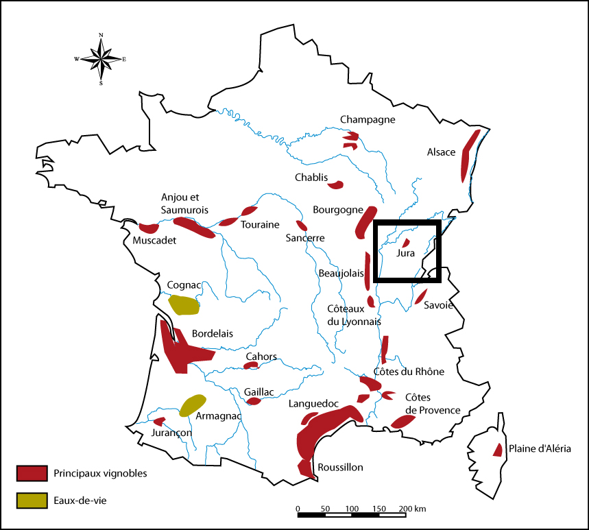
There is a similar mapping of economic exchanges rooted in a combination of microeconomics and taste in terroir maps. But the maps aim to create a social compact for an economic transaction that has yet to occur:  the mapping of terroir was conceived in response to expanded consumption,  as a cartographically refined register to track the authenticity of production of goods by crafting a graphic compact against fraudulent wines that protected the local vintner, rather than a statistical record of economic exchange. To be sure, the diversity of France was long predominantly cast not in linguistic, but agricultural terms, adding a special significance to the appreciation of terroir as a cultivated taste, and an appreciation of localities, tastes, and privileged access to individual regions, as much as a sense of local boosterism. The agrarian diversity of France was often cast in terms of bounty–the area of the nation that was without farms seems smaller than the regions dominated by cereals, but the areas of deep pink where vineyards grow, are distributed through broad swaths of the nation, if the largest continuous cluster is, famously, in the south–site also of the dominant vegetables of tomatoes and carrots.

French Agricultural Diversity

–but the terroir of vineyards reflects a geographically specific denomination, leading to a discrimination of the discrete localities by which the most savored wines arrived on a national, and increasingly global, market. But the globalization of terroir antedates its legal formulation in the French nation, and the tenacious grip of what seems a sort of enological copyright on a broad market for champagnes, and the tenaciousness of local growers to brand an increasingly broadly marketed appellation that they felt the need an economic imperative to secure .

French Agricultural Diversity

The 1908 definition of the terroir of Champagne set a legally binding definition of how the bubbly could be marketed under that name.  The definition set something of a benchmark for truth in marketing to fix authenticity of regional wines widely adopted to affirm the usurpation of any name outside the appellation–and reflecting to widespread trust in the objective truth of maps.

terroirs in France from CHampagne

The hope for graphically affirming how appellation was wed  to territoriality, analogously to the frontier of a state, may reflect a trust in the civil service, as the  Minnard map does.  But the format of mapping terroirs created lasting and continuing problems in the essentialization of the qualities of a wine’s taste.  The mapping of terrors provided an affirmation of difference and distinction, even when such variations as weather, humidity, shifts in soil quality, sunlight and a panoply of ecological factors themselves resisted clear mapping:  legislation culminated in the establishment from 1927 of formal recognition of the limits of viticulture, grape-harvesting, and pruning of vines within fixed boundaries that recognized the limits of provenance linked to approximate understandings of atmospheric character, quality of soil, and, in the case of Champagne, chalkiness.  The region of Champagne was mapped to define the distinctive region of finer deposits finer and more porous limestone soils, by limiting Champagne vineyards to some 15,000 growers, or just 3.4% of France’s vineyards, and set a standard that is still with us inherited today as an index of champagne legitimacy, and define the monopoly of its “authentic” producers–as well as establish the authenticity of Burgundy, Beaujolais, Bordeaux or Cognac as well as Loire wines:  if it is on the map, it authenticated.  Yet the notion of such a DOC is distinguished form territorial sovereignty or from recognizable divisions of landscape or space.

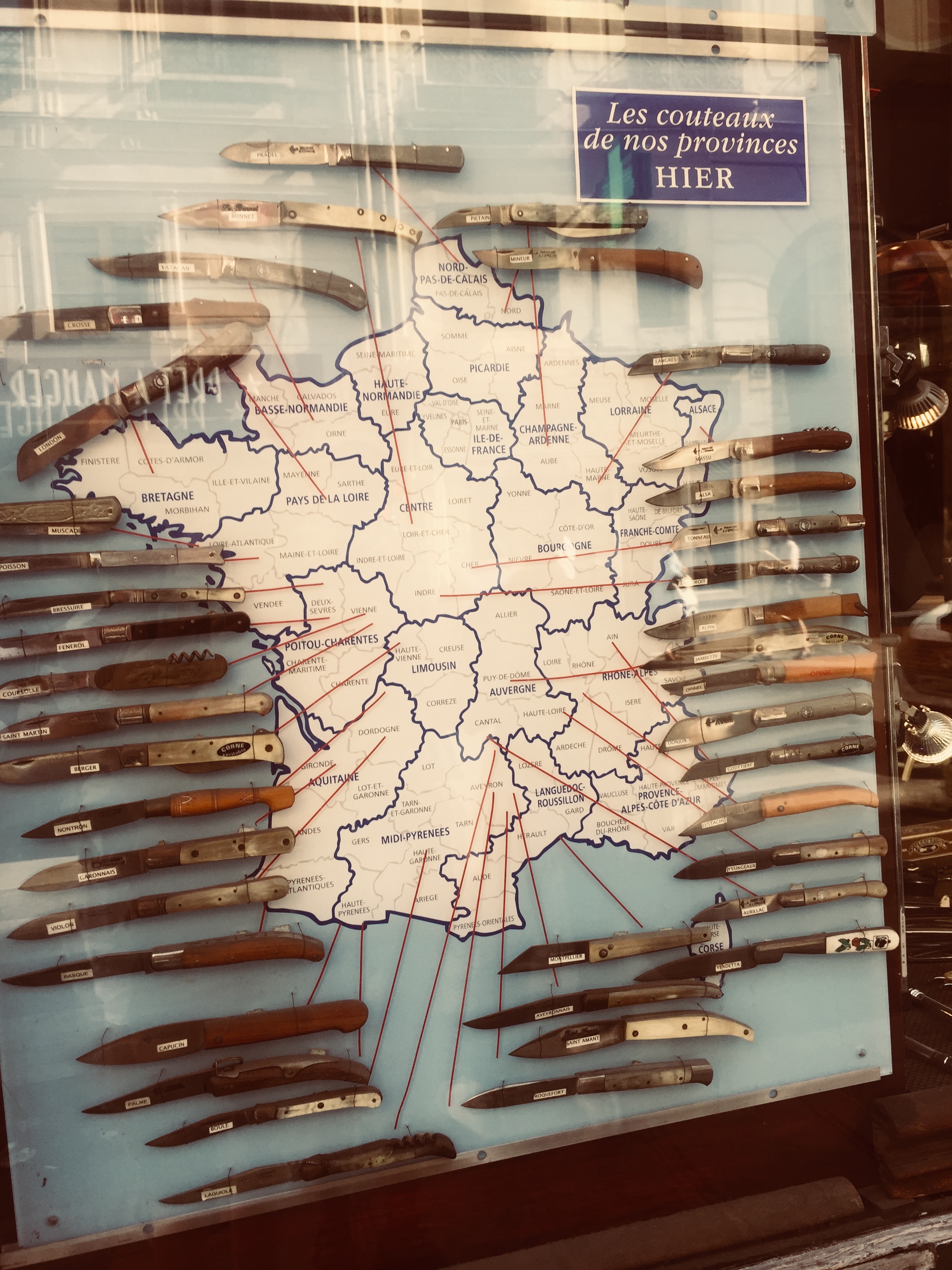
To be sure, in France, the image of a “terroir” is so naturalized within the geographic imaginary, that it can easily depart from the products of the”land” to be a synecdoche of regions, that may extend as a mnemonic of the copiousness of the varied past, as a shorthand for regional differences that extend from local knives–

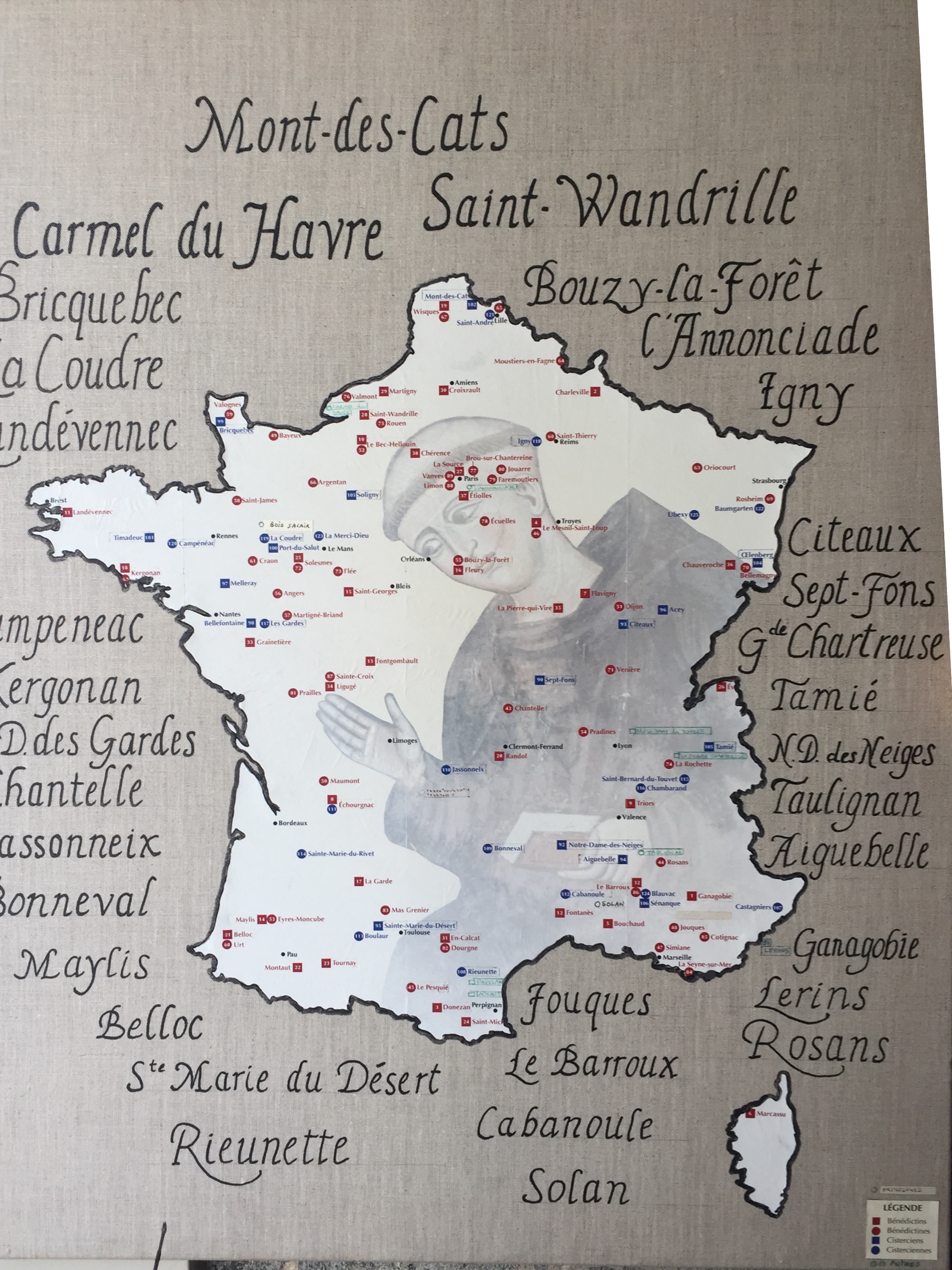
–to other elements of the past once inherent in the land, such as the old monastic orders–

–more than a mnemonic, the parsing of “terroir” has been scientized, in ways that suggest a purification of regional divisions on the basis of the minerality, air quality, relative moisture, solar exposure and wind patterns, as if the qualities of terroir could be parsed geographically to explain why the water of each region is distinct, and the viticulture the essence of inherent regional differences, whose specificity is to be fetishized on scientific grounds. The varietals of French wines were internalized and standardized on the international markets,

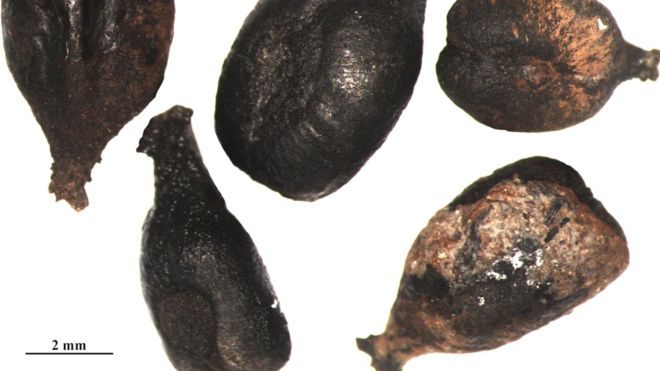
–and increasingly in web maps of wines that allowed customers to click on maps of regional wines to find their specific tastes, and even to read about the DNA links between wines of different regions, to create something like an evolutionary stemma of the relations between regional varietals–Syrah and Pinot Noir, for example, were tied, big surprise, to the same cuttings, and to Savignin Blanc from the Jura region, revealed a genetic database of contemporary grapevines, which also made its way int Central Europe under the name Traminer–suggesting how science may indeed somehow, slightly heretically, trump geography; the research into archeology of wine grapes suggest that the ancient grapes of the Savignin stock arose from domesticated berries, linking twenty eight grape seeds from the Iron Age and Roman era to seeds of wines that were, heresy of heresies, actually imported to the region by the Romans, suggesting the very sort of cross-border mobility and human presence that is often cleansed from the maps of wine varietals that we consult in most shops and wine stores.

But the wine map rooted in myths of regions’ mineralogy, water, sunlight, and climate have produced a parallel resurgence in the intensified regional localism–or localization–of wines, creating a sort of fragmentation of the wine map that absents humans, paradoxically, quite utterly, and privileges the “natural” differences of regions, rather than ties between grape stock, whatever kinship exists between ancient grape seeds that became prized by regions as their own–and as distinguished by the specificities of terroir to make them utterly unique from the wines of their competitors.

Domesticated Berries from Archeological Site in Jura

In an age when we must look for justification of the unique nature of branding, the demand for cartographical definition of distinction of regions’ wines–and the rights of distinct communities of wine-growers, may trump similarities among the stock of grapes that grow around the region of Reims, for example, from the Vallée de la Marne, Côte des Blancs, and Vallée de l”Ardre. The currant publications of amps may seem a not too bucolic over-abundance of cartographic promotion of localities of wine production and grape-growing regions dividing regions in France from one another to reflect the relative classiness of their profiles of wines, but also are an important way to secure a place in the market for wine producers, and affirm the continued value of the local in the face of globalization.

The objectivity of mapping techniques have come to the rescue to define a sense of territoriality among appellations. Recent advances in statistical mapping and geosciences of course created a far more complex definition of tracing of key qualities in the glasses, which greatly encouraged or facilitated a romance of attachment to local vineyards that was cultivated as much for urban tastes, taken as transparently or accurately translating local knowledge of viticulture to the marketplace in ways that intersected with cartographical practices and skills, even when upsetting usual notions of cartographical continuity.

CARTE DY VIGNOBLE DE CHAMPAGNE

There has been a huge demand, as a result, to adopt climatological and geomorphological criteria of mapmaking to defend the privileges of being able to use a given name, and invest them with greater objectivity and tangibility–or defend the rights to one’s DOC status, in an age when consumers usually balance limited access to information about vineyards with deep curiosity about identifying the intrinsic qualities of a given wine.  Each region has its own geological profile that determined the unique taste and quality of its grapes, full-bodied in the Montagne de Reims plateaux, influenced by limestone topsoil in the Vallée de Marne,  whose topsoil is distinguished by chalky layers of Belemnite and Micraster, or Kimmeridgian soil in the Côte des Bar. The definition of such distinctions are increasingly important in a global marketplace for wines, swamped by cheaper if less well-known wines, where the huge range of the scale of prices, often for status conscious audiences, finds many challengers in the growth of low-budget wines.

Clear regional variations of Champagne soils acknowledge the difficulty to essentialize or claim any clear and distinct correlation to minerality or land-type.  They balance these, however, with the need to mythologize the practice of restricting practices of viticulture in bounding a regional terroir, in ways that foreground the benefits of the diversity and range of authentic champagne on the basis of regional soils of different geological epochs:

Champagne soils

3..  Terroir is of course re-mapped in terms of the experience of of tasting a given wine.  A predominance of descriptors are linked to values of minerality in ways that romance the ties of wines to the qualities specific to the earth that nourishes wines.  As well as fruits or flora, think of the many descriptive notes that summon the physical characteristic of place that determine individual taste:  earthiness; minerality; grassiness; stoniness; crushed rock; chalkiness; crumbliness; gravelliness; paving stones; hints or flavors of slate, schist, or silex–that suggest an un-mediated expression of a region’s geology, as if the taste derived from a geomorphological profile, rather than being judged by the wine-drinker.  A simple cross-mapping of viticulture and soil qualities reveals the constructed nature of wine regions, and undermines the terroir map’s naturalization of uniform local geological profile or soil-characteristics:  this cross-mapping of viticulture and soil qualities reveals the constructed nature of wine regions, and the constructed nature of any attempt to naturalize regional provenance by a single geological profile.

Geological:Wine Regions

–and the absence of uniformity in the boundaries drawn in maps defining practices of viticulture in such evocative and recognized regions of wine-growing on the banks of the Loire and Rhone:

Central France-Loire and Rhone
LOIRE WINES

As in the case of any map, nature is recast as a varieties of expertise.  Other factors including wine preparation, grape cultivation, relative humidity, exposure to sun and weather are more determining of taste and quality of the wine than terroir–and those not sold on the identification of wine by terroir alone find cool opportunities in the marketplace for French wines.  Terroir is something of an artificial construction on grape-growing on a cluster of fields, that is able to be all too quickly essentialized as an index. Territory is essentialized as an authoritative measure and standard of oenological quality:

Marsannay Terroir

Is there a more recent deconstruction or fragmenting of the wine map to the degree to which appears the case, as terroir is affirmed by subdivisions to situate taste in a specific location?

The parsing of terroirs to best express the complex relations of vine and ecological environment has led to a refinement of the simple bounding of a region to a detailed examination of the relationships between soil quality, geomorphology, and the inclination of the slopes of vineyards in the Douro region to better discriminate and region’s DOC criteria, employing a full range of color samples worthy of Kelly-Moore, using a palette of innumerable varietals to distinguish wines’ tastes:

geology, geomorphology, slope inclination of DOC Douro

Or of the DO in the Cigalle, the soil map throws into three dimensions an almost plastic record of local geomorphology, here represented at a scale of 1:50,000.

D.O. CIgales, 1-50,000

To preserve the complexity of taste-variations within a single terroir, this map discriminates five sub-divisions in a single region’s vineyards:

terroir classification- 5 subcategories

It is difficult, if not impossible, to effectively rationalize the contributions of different climactic and ecological variants within a region that can be mapped in such transparent ways.  And yet the placement of the bottle on the terroir map is a sign of quality, and a reassurance of protection in the marketplace of a substance whose varietals are difficult to substantiate as natural, and whose qualities are impossible to naturalize by provenance; and so we use the map to denote  distinction and draw clear differentiation among oenophilic competitors, to draw sharply distinctive origins around riverbanks, across a varied mosaic of geological differences.  The mosaic of regional wine differences masks the minimal differences drawn by aromatic descriptors, but surely masks the indeterminate nature of actual data by presenting them as inherent in the region’s micro-climates or micro-ecologies of increasing geographical refinement.

Mosaic of Minimal Differences

The notion of such protection of local farmers and monopoles on terms are far less rigorously defined, it seems, among the less homogeneous or centrally administered cultures of Italian cities in Tuscany, who have competed against one another to define the propriety of assuming the title of Chianti, albeit by accommodating chianti classico, chianti colli senesi, and chianti from Felsina

DOC map chianti, Felsina, Chianti Classico, chianti colli senesi.png

The less official cartographic representation–although this map with an apparent provenance from a wine label seems remarkably detailed.

4.  So habitual is the mapping of terroir that the mapping of California wines became a means to invest the grape with a level of distinction and proof that it can hold its own; status is effectively conferred by a recognized coloration of recognized regions of viticulture.

Napa Valley was the first recognized “American Viticultural Area,” in a polemic response to French assertion of terroir by 1981, after years of its popularity and promotion, as if in final response to the denunciation of lack of recognized terroir among California wines.   Robert Parker had indeed felt so lambasted by terroirists who “latched onto terroir in the 1970s,” to critique California vintners and wine-promoters for imposing a “bland style” of wines on the world of buttery Chardonnay and bold Cabernet–whose powerful fruits were cast as deracinated without Old World structure.  As California wines were cast as the yuppie of global beverages,  lacking distinct provenance, the mapping of the state’s wines provided a platform from which to assert their legitimacy.  The maps of regions of wine-growing in the Napa Valley had been so widely absorbed an aesthetic of the pastoral by the 1990s as to create a conceptual mapping of the rural vineyard with clear social implications that migrated from tourist maps to popular ephemera.

Napa Valley-Wine Country
California Terroir

But the arrival of wine-maps that designate regional appellation afforded an index of taste and a visual charting of tasting that was almost a necessity of marketing in the land of micro-climates.  Mapping California terroir spawned a complex variety of mapping a region that, while first confined to Napa and the coasts, rapidly spread over time both into the central valley and far further south than would have been thought possible.   Steve and Mark De Long’s “California Wine Map,”  sold in its first edition of 2009 as a work of “essential reference” has come to catalogue all the 108 American Viticultural Areas that have been recognized since 1981:

Such maps offer concise arguments for oenological legitimacy–foregrounded above by the inset map of Napa.  As aesthetic statements of a wine’s origin, they map nicely onto the recent explosion of taste descriptors–rather  than map the local geography in ways that a future vintner would consult–although it is an index to a vineyard’s price:  although soil-character is an index for conditions of good viticulture, the vineyard after all precedes the map that places it in a value-system.

The recent explosion of northern California vineyards necessitated re-classification by terroirs–if only to combat the idea that Californian terroir is difficult to establish rigorously, and California wine not equal in authenticity to French, and contain the perfect ecological balance into which to transplant, say, Pinot.  In Mendocino, Castle Rock Winery assures us, the wine’s nose is distinguished by “headwaters of the Russian River carve a fertile and rugged landscape” in which the cool springs, crisp falls, and wet winters” for Pinot Noir, made apparent in analogies to the Burgundy region of France where the grapes were first grown.  Although multiple factors inflect the taste of the wine as it ages, from the cleaning out of barrels to the quality of the oak or wood, to the spraying of grapes or amount of residue on their skins’ surface, Castle Rock proclaims the source “handcrafted wines from some of the finest appellations on the West Coast: California (Napa Valley, Sonoma County, Carneros, Mendocino County, Monterey County, Paso Robles), Oregon (Willamette Valley) and Washington (Columbia Valley),” linking the wine to the terroir to comply with a code of compact for the consumers benefit by the promise to focus their attention to the selection of regional terroir.

Are the maps of terroir ever of interest to the vintner, or are they as indispensable–and as inevitable–artifacts of the market to the same degree as the combination of 120 florid decriptors in the tasting notes, often designed to manufacture the nose as much as generalize the individual palette?

wine-descriptions-chart-infographicx

To be sure, the currency of descriptors of tastes on the market is so confusing that tube-like infographics have gained currency on the market to clarify and open access to the recognized oenological lexicon of aroma descriptors that has been standardized in the food sciences, as if to orient readers to the secret terminology by which to discuss their tastes:

When David Gessen imaginitively transposed tasting routes from a rural setting to an urban iconography for visitors to northern California, he wanted to remind us that he was on his own home turf.  He is sure-footed in his visual transposition of wine-tasting routes that attract regional tourism in Northern California and counties around San Francisco to a metro map–the transformation of terroir in California was at first mostly for export, but also increasingly addressed California oenophiles far beyond the francophilic community–and Gissen is on target when he re-charts the major grape varietals of the region in a oenological version of what now appears to be a state-wide BART map, as if to suggest the access to wines Northern California’s many viticultural regions allows.  To be sure, the map expanding the service of Bay Area Rapid Transit System to the surrounding region that the actual transit system fails to adequately serve, but blends rural and urban in a range of blends that are designed to be savored:

MetroMapCA

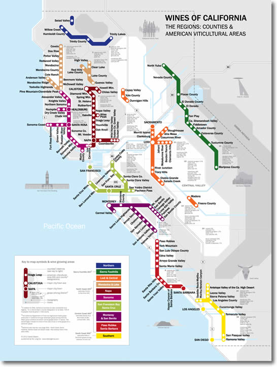
This is not a wish-fulfillment vision of the expansion of BART tracks to vineyards, however, but a recreation of terroir and a translation into Northern Californian terms.  But the map reminds us of the degree to which such maps are about capturing the trust of the consumer, and providing grounds for the common tasting of new wines.  The most refreshing aspect of the map is its open-access invocation of public transportation, transposing  BART paths to the far more mystifying obscure combinations of regional terroir and aroma descriptors pronounced by the sommelier schooled in such classifications.  The map’s detail, exemplified by this section of the Santa Clara Valley, differentiates the proportional percentages of varietals of each region with impressive precision, and casts a progressive wine-tasting on an imaginary sequence of BART stops:

Santa Clara Valley

For the map is literally asking us to come along for the ride, inviting us to explore the terroir by well-known paths, lest we lose ourselves in the Napa vineyards along with the busloads of tourists who travel there for wine-tasting every year.  The map both mediates and preserves criteria for the elite experience of wine-tasting, and the imagined sacred communion with a select and privileged region that is re-enacted with each glass of wine.

Leave a comment

Filed under California, California wines, Northern California, tourism, wines

Mapping New Worlds on Eggshells: Adventures in the Artifice of Renaissance Map-Making

We have learned to expect to pause as Google Maps draw boundary lines, extending to new tiles which soon take forms bounded by in clearcut lines across uniformly flatly colored quite static blocks, as data streams materialize forms from blurs that delineate highways, city blocks, state boundaries, and mountains in gray, green, tan, or light blue–a poor surrogate reality that strongly contrasts to the vivid ways we experience space in early modern maps and globes.

 The convincing nature of the watery globe was far more pronounced in an era when the ocean provided the only medium for global travel, to be sure, and the immediacy of rendering oceanic space far more of a concern of global mapmaking.  (Indeed, for a more extensive consideration of map authorship and the concerns of its representation of oceans, see my post on its mapping of ocean waters.)  The  medium of the woodcut presented unique challenges of mapping the circumambient oceans, not defined by clear routes or itineraries, but as a unique medium of travel. The curving lines that lapped the shores of inhabited lands in an early map of northern Europe, reprinted as the endpaper to a universal history, the Liber chronicarum, ad derived from a map of northern Europe before the “discovery” of the New World, that set places and regions in northern Europe apart from a wavy sea–

33675mp

The northern seas are denoted by individual lines echo a global bifold map the same 1491 Liber Chronicarum, just predating the discovery of the New World, a detail of a crudely engraved world map in which one sees swirling waters that encircle the island of England and indeed all of Europe–and make one think of the difficulties of reconciling and bridging different registers of mapping land and sea for readers in the late fifteenth century.

Ocean curves.png

Unlike the on-screen conjuring of a demarcated space, the design of early modern maps invites detailed examination.   This undated miniature globe, engraved with considerable care on a two conjoined halves of two ostrich eggs, the size of a grapefruit, invites viewers to sail on the seas that swirl around a record global totality as something like a surrogate for actual world travel, its carefully worked details leave a clear trace of the hand, if not betraying the new phenomenological properties of the surface of engraved maps.

Although maps are often though of as paper constructions, the new properties of synthesizing land and sea in Ptolemaic maps are quite similarly approached in the very unique surface of this strikingly tactile engraved map–joining rounded halves of ostrich eggs–

Ostrich Egg Globe (1504)

–invites a distinctive attention to similar circumambient waters, which flow about the continents on whose surface we can see clearly engraved and legible toponyms: the seas are far more murky, as if they land had been the only legible area that was raised from their depth. The raised nature of the terrestrial surfaces on this globe–where the oceans are literally scratched away form its surface, as are the chains of mountains, coastlines, capital letters indicating terrestrial regions, and limited toponymy, suggest a marvel as much as a terrestrial map, and remind us of the interlinked discourses of maps and marvels, and the collection of curios as vehicles and mediums of geographic knowledge.

The engraving of a newly imagined expanse reported in marine charts created quite distinct operations of visualizing a newly materialized space–it displays one of the first maps to be printed that showed the New World’s form and recalls  the earliest printed images of North America.  The islands of “Spagnola [Hispaniola]” and “Isabella”, barely balanced with the huge area that it assigns to the Land of Brazil, or “Terra Sanctae Crucis” in something like an antipodal balancing act of continents around the equator, opposed in counterpoint to the Eurasian expanse. The coverage of the watery surface in the globe–which is in fact mostly covered by water–is even more pronounced in this apparently unique globe, composed of joined shell-like structures, treating the durable surface of the shell to create a luxury globe, which cannot, in its own way, but recall the famous apocryphal story of Christopher Columbus displaying the invention that was widely associated with cartographic modes for displaying the New World in flat maps, by challenging “lay a wager with any of you, that you will not make this egg stand up as I will, naked and without anything at all,” related in Girolamo Benzoni’s 1565 Historia del Mondo Nuovo [History of the New World], to compare the achievement of his discovery of the New World from “great men clever in cosmography and literature,” by the act of forcing the egg to stand on a table by allowing one end to be placed on a table as a support.

The eggshell map has no broken ends, but in its newly discovered form indeed stands on a table, allowing the observer to view to ponder the entire spherical surface of a globe, engraved on two ends of an ostrich eggshell, perhaps originating from a princely zoo, that lent itself to offer an exotic surface of cartographic demonstration to its privileged owners, quite unlike the manuscript or printed maps that are associated with early maps o the New World in the materiality with which it suggests the long voyage across oceanic expanse to reach a geographically enlarged (and now clearly out of scale) image of the New World islands, north of a creative rendition of a newly discovered South American coast, identified as the Terra Sancta Crucis, as if to retain the Christian eschatology even in the revelation of a world whose form seems foreign to whatever geographic knowledge is revealed in the Bible: the new islands of Isabel and Spagnuola are themselves court creations of Columbus’ royal patrons, and inscribe claims to sovereignty to these new lands, but the invention of the ostrich globe, recently discovered over four centuries after the discovery of the Americas,

Did the discovery of this inventive form of globe-making, unprecedented in the literature, link inventively, artifice, mapping and eggs that afforded a basis for Benzoni’s apocryphal claim?

New World in Ostrich_egg_globe

If the opposition of these continents in the ostrich-egg globe betrays significant cosmographical learning, the map itself reflects curiosity in the first mapped images of the New World, and a particular care to the definition of the coastlines of the newly found land masses we now call continents.  The exquisite care and delicate relief of the globe’s surface in this delicate construction made from two ostrich eggs has been recently dated to 1504 by its shell-density, based on a CT-Scan.  If the date can be ever established conclusively, the globe is one of the first images of the New World to have migrated from Portuguese marine charts to a particularly skilled level of craftsmanship, predating some of the known bronze globes of terrestrial expanse it resembles;  the image of Europe, Asia, Africa and the Land of Brazil could be scanned in analogously crisp detail to known early sixteenth-century globes and printed map-gores.  Indeed, the range of graphic tools engravers developed for embellishing the surface of maps set something of a standard for scanning land and sea, as their exquisite tones of shading increased the persuasive range of graphic forms that the anonymous artisan who made this eggshell map exploited to delineate the inhabited world.

Continue reading

Leave a comment

Filed under early modern globes, histories of discoveries, Mapping the New World, New World, Renaissance Discoveries

Mapping an Invasive Species? Eucalyptus in Berkeley, CA

The mapping of invasive species on land or sea provides one of the clearest ways of visualizing our shifting ecosphere:  in mapping of the threat of invasive marine species to coastal ecosystems, Michelle Slosberg developed her marine map of the spread of invasive species in 2011 when an undergraduate at MIT.  She did so by mapping sites of high-risk areas of marine “invasions” along coastal waters, geo-referencing data on ballast water of ships to determine the risks of the presence of invasive species that were carried by ships from one ecosystem to another and specific to the northeastern coast of the United States.

Invasive Marine Species Mapped

The vectors of travel in ballast water are shockingly widespread, and the container ships traveling from China to across the Pacific, or along the Atlantic, increasingly import species accidentally that are rarely noticed until they propagate:  the number of harmful alien species mapped worldwide have so grown that some 84% of the world’s 282 marine ecosystems are documented to contain invasive species, and in 2008 coastal regions with harmful alien species were dense in ecoregions in the Mediterranean, in the North Sea, and along the California shore and Hawai’i.

number_of_harmful_alien_species-1

Blue waters note areas where fewer harmful alien species were found to dwell.

The complex vectors of marine migration of alien species have only begun to be mapped, but heighten anxieties about the definition of “national waters” or marine borders, increased by shifting temperatures of ocean habitats and lend new meanings to the maelstrom of modern life:

Major Pathways of Marine Invaders


Fears of the heightened potential of geographic relocation of species by mapping points of transfer paths of airline flights offer by linking regions of similar temperate zones:

map invasive_species

The category of the “invasive” redraws spatial boundaries–and inflects taxonomic identifications–to suggest a shifting map of the natural world, combining nature and culture and resisting the stability of a fixed map.  But mapping the spread of “invasive species” often charts less an invasion in early stages of development than a process of resettlement, as in this map of wild carrots that flourished after they arrived in our national borders 250 years past, but still classified as weeds in mid-western and north-western agricultural fields:

WIld Carrots in US

The wild carrot seems relatively benign, and was introduced at about the same time as domesticated carrots to US farms. But the introduction of eucalypts from New Zealand redefined the Bay Area, where I live, and the exploding trees that are native to Australia–where they are known as “exploding trees” and played such a large role of combustibility in the recent bushfires where they provided exploding fire balls in the air that led to the advance of walls of flame when sustained drought increased the volatility of what became an explosive landscape, a flammability transmitted through the flammable fumes created by vaporized eucalyptus oil.

Australian residents have long called the native species “gasoline trees,” rooting them in an anthropocentric landscape or imaginary, whose highly combustable oils are released in fires, and whose explosions–sometimes sending parts of their crowns to spatially removed sites–create their ability to magnify grass fires into explosive threats of devastating scope, ramping up the danger and scale of the bushfire in what seem spontaneous combustions geographically removed from one another without any predictable pattern. The explosion of euclyptus crowns that can travel fourteen miles in the air increased not only the intensity but geographic distribution of the Australian fires. But the explosion of eucalypts immediately known in the Bay Area was revealed in the Oakland Hills Fire of 1991, when the explosion of blue gums contributed some 70% of the energy during the devastating fires that destroyed upwards of 3,000 homes over days, leading to calls to remove the tens of thousands of blue gums and other non-native species from the ridges that had so long seemed to be a part of the local landscape for Northern California residents who had celebrated their health benefits soon after since their arrival in the late nineteenth century. While they soon exploded, the density of thin Eucalyptus crowding once open spaces raise questions of whether they belong or don’t in this landscape–and what sort of roles the eucs have and what they are even doing there.

Dan Rademacher, Eucalypts North of Claremont Avenue, East Bay

The danger of labeling an “invasive species” by mapping its lines of incursion is to constitute a category that elided the existence of external environmental influence.  But how to chart the undeniable impact of commercial practices or climactic shifts that serve to facilitate the geographic dispersion of an ‘invasive’ species?   The piles of perfumed litter that fill the roadsides of many of the East Bay hills, cascading downhill into the road, provide a nice remembrance of nature, but also are undeniably dangerous kindling for future potential fires, releasing oils in the air not only powerful in fragrance but combustible. And the multitude of Eucalypts that we see locally echoes the spread of blue gums and other eucs across delicate habitats across Malawi, South Africa, and Chile, crowding out local species, as in Patagonia; these large fast-growing plants of Australian origin suck up water and cast shade over other plants, and foliage, crowding out other native plants, in ways that don’t create calls for nativism–but biodiversity.

What of the habitats they afford or create? In the East Bay, the euclypts that crowd the hills are improvised shelters and sights of nesting for the elevated platforms that red-tailed hawks take as their eyries, advantageous for their height and stability to allow them to swoop down, and the great horned owl who often succeed them in the same sites of roosting. But the benefits that eucalypts afford these larger predators are cause for worry in themselves as creating imbalances in the delicate dynamic of the biodiversity of any place, as Allen Fish, who directs the Golden Gate Raptor Observatory, and has noted the advantages that shelter in tall trees can give to some species over those that, as raptors, occupy more specialized ecological niches: the eucs may often afford the larger avian predators a privileged position to swoop down into the smaller birds such as kestrels, spotted owls, screech owls, saw-whet owls, and and Coopers’ hawks, or even provide habitat for red-tails who will crowed out sensitive species from the grasslands and savannah, including long- and short-eared owls, and barn owls, that provide a fundamental role in habitat. How to map the effects of such invasive species in dynamic ways, as altering the ecosystems we often separate from maps?

Indeed, mapping the species’ ‘invasive’ nature–or even the term “invasive”–effectively renders transparent the identity of the pernicious plant as a bacillus, deflecting agency from economic practices to the collective species labelled nonindigenous; such maps become distorting lenses to foreground effects of a species’ dangerous tendencies to spread over space that remove blame (or responsibility) from the economic or climactic change to locate it in the species it tracks, and indeed flatten temporal change:  maps of invasive species prove a perfect example of the strategies for the power of map-signs to reframe the experience of nature illuminated by Denis Wood and John Fels.  A classic case is the dangers of rapidly reproducing predatory lionfish through the Florida keys, which having migrated or “arrived” from warmer ocean habitats threaten to destroy local marine life, whose presence can be highlighted, removed from its environment, in a striking map of its marine spread:

lionfish_dis_map

This sort of cartographical compartmentalization circuitously brings us to the battle over local eucalyptus trees, conducted largely around the invasive nature of nonindigenous Tasmanian blue gums long rooted in groves in the landscape of Bay Area hills.  Invasive species of plants are nonindigenous plants that spread in uncontrolled ways to an area they have never lived and lack predators, creating environmental problems and contributing to the extinction of native species and animals.  But how long can a plant be present in an ecosystem and continue to be labelled invasive?

Although airline traffic, like routes of ships, expands the network and increases the speeds at which seeds migrate across the earth, increasing the vectors of moving invasive species by accelerating contact between regions that did not share borders, introduced species–some 50,000 now exist in the United States–is conditioned by the suitability of the environments they arrive–few of which are on the west coast, although the travel of weeds alone cost California at least $82 million per year.  The very virulence of terminology to identify plants and animals as invasive–perhaps the biological threats of a postmodern age–has conditioned how we see the landscape before our eyes.

Recent debates around the proposals to clearcut 22,000 non-native trees in Strawberry Canyon and Claremont Canyon reveal a pitched battle in the Berkeley Hills and Claremont Canyon around labelling the Tasmanian blue gum eucalyptus as ‘non-native.’  Whether or not the Tasmanian blue gum eucalyptus  (Eucalyptus globulus) is correctly labeled as invasive is not only a question of fact, however, but reflects how one maps the place of the towering blue gum trees in the landscape they have created and long lived–and how one maps them as signs of fire-risk.  The removal of the trees that cover a large part of the hills, especially on the west-facing hills of Berkeley and Oakland, from the environment when mapped for clear-cutting, revises their place in Bay Area landscapes, and the struggle that emerges among environmentalists and planners (or local constituent groups, since the division is not so clear) reveals a battle between landscape and map, or a naturalized landscape of welcoming groves and a firescape dotted with unwanted risks, but also offering transcendent moments of their own.

timthumb.php

Many land-owners share deep-running concerns about the fire-dangers created by the branches, shaggy bark, leaves, and seed-pods, all containing highly flammable oils, and explosive proclivities of eucalyptus trees:   multiple vectors of encouraging fire-risk have led the tree to be demonized as primary culprits of the disastrous 1991 fire in the Oakland hills that destroyed so much property and claimed 27, as well as forest habitat.

The characterization of the tree as an invasive–and even as a weed–are all rooted in its change on the landscape, as much as unquantifiable expansion of fire risks.  None seem greater than the piles of as the bark that, shed, create a dry ground cover that inhibits future plant growth, and raises the specter of quickly igniting kindling that stimulate powerful underdrafts after its combustible oils ignite that would push a wildfire’s growth out of control, as updrafts push flaming bark ahead of the actual fire-front, onto the roofs of nearby houses, at the same time crown-fires spread the canopy of leaves create crown-fires among towering trees that carry the level of flames into the atmosphere.  Once their combustible oils ignite, leaves and litter are feared to fuel a raging fire, offering firewood as groves of Eucalyptus themselves explode and ignite.  Hence the fears summoned by imagined firescapes expanding by burning crowns and flaming bark thrown by winds that are provoked by those leaves’ presence.

eucalyptus

So what are the abilities to contain this vegetation whose vigorous spread seems to obstruct the growth of other plants in the ground area they cover by displacing native plants?  Attempts to map areas for their elimination reflect the fears of property owners, recently saddled with newfound legal liability for responsible land management, and responsive to the availability of federal funds to land management in the hope that future fires would not consume the lands they manage or impinge on nearby houses, and create any suits of environmental liability.  If causing huge financial damages is hoped to be avoided, the question of legal liability seems to have been the primary factor that motivated further attention from large-scale land-owners as the University of California or regional parks.  Already by 1991, the University of California at Berkeley began to clear thousands of “invasive” eucalyptus within the purple section, as part of a larger ten-year plan to remove 25,000 trees from its property–or the grove in the below aerial view in the Claremont Canyon, in projects of “land management” directed to such a reduction of risk.

Claremont Canyon Fire Mitigation
fire_pix

In December 2009, these plans received a setback as FEMA denied four separate grants to the University of California, Oakland and the park system for $5 million to remove eucalyptus, pine and acacia trees from the ridges above Oakland and Berkeley, but plans to for clear-cutting some 82,000 Berkeley and Oakland trees, a quarter of which lie in the protected Claremont and Strawberry Canyons, to be followed up by 700-1400 gallons of herbicide in land belonging to Regional Parks.  Similar interventions clearing eucalyptus encouraged the large-scale project to clear-cut the eucalyptus from the hills–dramatically revising the landscape of the region to be reforested by “native” plants whose seeds may lie buried by eucalyptus litter, and would be re-introduced after careful extraction of each and every blue gum.

The hills were colonized and indeed filled by eucalyptus, and most especially the Australian import of the Tasmanian blue gums, around UC Berkeley’s campus, in Regional Parks that could be said to themselves litter the  Berkeley and Oakland hills–Tilden, Wildcat, Kennedy Grove, Anthony Chabot, Lake Chabot, Redwood, and Sibley–where the planting of eucalyptus replaced grasses and wildflowers that covered the region, as in this image of the stately eucs that provide posts for Kennedy Grove.

Kennedy Grove

Yet there is some evidence–not widely acknowledged–that cast the eucalyptus as something of a windshield whose presence in dense groves, by blocking winds, would actually fights wind-driven fire, acting both to break and interrupt the flow of the wind that bears the fire and as a screen to trap flying embers that might be in danger of spreading and starting wildfires.

The decision of UC Berkeley to once more seek needed FEMA funds of $5.6 million to fund for the clearcutting began in 2013, with hopes target an expanse of some 22,000 non-native trees from Claremont and Strawberry Canyon, in order to mitigate fire risks for residents haunted by the devastating firestorm that swept through the Oakland Hills in 1991 Oakland Hills that destroyed some 3,000 homes in the hills.  Many residents remember the Eucalyptus as fostering the rapidity with which the flames of the raging fire spread across the hills:  as “fuel-productive” trees that produce huge quantities of combustible litter, they are readily labeled high fire risks, and have few protectors.  Even though some 19,000 non-native acacia, blue gums, and Monterrey pines have already been destroyed, the destruction of the expansive grove destined to be felled and chipped would potentially end a major protective windshield, but would no doubt reduce how we quantify fire risk.  

And the current thinning of Eucalyptus and other invasive species as acacia and Monterrey pine in the regional parks in the East Bay hills, despite the mobilization of a community-based Hills Conservation Network (HCN) to protect them, will cover 2,000 acres, targeting diseased and dying non-native trees as much as converting the region to grasslands, leave a forest spotted with chemically treated stumps where trees once grew.

1024x1024

920x920-3Paul Chin (S.F. Chronicle)/July, 2015

Native Americans regularly burnt grasses to encourage their growth and spread their seeds, inhibiting the spread of trees. This allowed a massive spread of eucalyptus was so extensive in the grassy hills, where they were planted, erroneously to impede further local grass-fires.  The importation of the eucalyptus plant from 1850 was not only for ornamental ends, but to create fast-growing hard-wood forests was originally celebrated–if incorrectly–and presented, strange to say, as a further reduction of hazards of fire that regularly broke out in the grasslands.   They were also screens, to be sure, for further construction of residences and houses in the hills, valued as protective natural obstacles for privacy as houses gained increasing density on the hillsides, placing neighbors in greater proximity than they had wanted–and perhaps offering an even more welcome screen during Prohibition for private parties, as the eucs became part of the Northern California atmosphere, viewed largely as benevolent, convenient ways of adding further salubrious greenery.

The arrival of the trees in the Bay Area was spawned by unsuccessful lumber schemes, designed to meet the needed infrastructure and housing materials for the region’s growing population.  When the Judson Dynamite and Powder Company first introduced the tree in the 1880s to use their canopies and dense foliage in order to hide ravages of construction and muffle sounds of explosion or construction, the trees’ arrival was greeted in local papers as offering relief from the regular grass fires “that almost every year swept over the hills,” as was argued in the Oakland Tribune–a somewhat common-sense theory that research as now revived, although the argument that they offered wood that resisted burning was openly fraudulent.   At any event, the species robustly grew on plantations of trees as Frank Havens’ land company–the Mahogany Eucalyptus and Land Company–planted some three million eucalyptus and Monterrey pine in plantations of 400-900 trees/acre across 3,000 acres in the East Bay, billing the tree as “the most valuable on the face of the globe,” offering hardwood for fences, firewood, shingles, telegraph poles or “ecclesiastical furniture.”  

The tree seemed magically powerful not only in the rapidity of their growth, quickly attained huge heights, but the multiplying of trunks from their bases so their wood could be regularly re-harvested:  yet as it was realized not to be quite so suitable for milling, and  readily cracked, Eucalypt monoculture became jungles able to suck water out of the ground, leading to calls to thin the population that crowded out native species.  As the difficulty of combatting its fires became clear, the survival of the eucalyptus became something of an economic dinosaur that had outlived schemes for the sudden profits of crops of wood.

One can map the spread of the species first planted to disguise sites of construction, mitigate disturbing sounds, or create miniature parks or groves, to a mini-industry of plantations.  But can one ever map the losses or the density of Eucalyptus trees in the Oakland hills?  One can hardly call the tree non-naive to the state, given the century-long spread of the mid-nineteenth century arrival across different micro regions and environments from coasts to valleys to foothills to dry desert:

Eucalyptus globus state-wide

The prime danger that the trees pose to fire is in shedding their foliage, particularly after colder weather:  the 1972 freeze led trees to shed some 50 tons of debris per acre, over an expanse of 3,000 acres, creating a tinderbox of bark; the shedding was cleared by federal disaster funds.  The 1990 freeze played a considerable contribution to the disastrous 1991 East Bay hills blaze which consumed over 3,300 homes, and led East Bay landowners to work to prevent risks of future fires.  Regular clearing in times of intense shedding of shaggy bark–the eucalyptus trees’ “litter”–surely poses a more economic response to the need to mitigate fire risk.

But the characterization of “match sticks loaded with freeze dried fuel” shifted the blame from dead grass, wooden houses, and vacant lots–and points the finger at the invasive tree, and particularly to question its proliferation on public lands.  Loni Hancock, then Berkeley’s mayor proposed chainsawing down thousand of these “invasive species” or “weeds,” to reduce the dangers of fire-risk–albeit while creating dangers of soil erosion and changing the habitat.  The wide planting of the tree throughout the state not only served needed screens or decorative cover, but valuable fence- or scrap-wood and firewood, given its quick growth.)

sheddingbark

The “disorderly” trees that did not clean up for themselves were labeled “invasive” and even identified by the evocative term  “unwanted immigrants” that needed to removed from public parks and lands conceals the risks equally posed by landscaping with non-native shrubs or Monterrey pines.  Tasmanian blue gums have, no doubt because of their visual presence, coppicing, rapid growth, and towering size been seen as weeds, and also been defended as “native enough”–as residents of over a century and a half–continuing the arboreal personification and obscuring debate.  

Berkeley-based poet and Poet Laureate Robert Hass, longtime friend of the eucalyptus’ shaggy bark and camphor smells, got in on the fun when vaunting the blue gum as “California’s largest naturalized citizen,” aware of the serious stakes.  The debate on the trees’ status as alien immigrants set the stage for Verlyn Klinkenborg to enter the debate about “non-native” status of the blue gum eucalyptus, noting that the tree’s exclusion from a “native” land that existed over five hundred years ago relies on a pretty “imaginary snapshot of this continent taken just before European contact,” and, in omphalocentric New York-ese, questionably comparing their place in the landscape to the evolving arboreal landscape of Central Park, whose variety has long welcomed interlopers and foreigners in ways often imagined as a microcosm that reflects the urban population.   The point being that the landscape evolves.

But to shift from a human-centered approach to the place of eucalypts in our environment, it may make more sense to ask the overall environmental impact of the shedding trees.

Yet the California Native Plant Society deems “native” only species predating European contact, and the concerted efforts of public lands to strip the areas that they administer of fire risk have led to a huge investments of regional park and utilities corporations, no doubt eager to respond to insurance threats, to eradicate the blue gum from the local landscape, labeling it as a tinderbox to be uprooted.  A broad range of local authorities who administer parklands–UC Berkeley; City of Oakland; East Bay Regional Park District–have tried to secure up to $5.6 million  from FEMA’s Pre-Disaster Mitigation Grant Program to mitigate fire risk by a plan to remove tens of thousands of eucalyptus.  The group of suspicious non-natives—eucalyptus, Monterey pine and acacia—would be removed in over 1,000 acres, in hopes to expand the indigenous oaks that eucalyptus first replaced.

The 2010 result was to put a mosaic of vegetation management on view:

Proposed Actions on Eucalyptus

The 2010 report proposed Hazardous Fire Risk Reduction measures largely administered by the East Bay Regional Park Development:

EBRPD
EBRPD 2

Or, in the most focussed picture of mitigation in the regional parks of the Oakland and Berkeley Hills:

Tilden Termination of Eucs
key

Yet local environmentalists’ have resisted a plan to begin with clear-cutting of Eucalyptus trees, followed by annual application of herbicides, and then five to seven years of pulling seedlings–not only for posing risks to local endangered wildlife, from the whipsnake or California red legged frog, as members of the Hills Conservation Network argue, but may well stand to create even greater fire risks.

Yet the classification of the tree as “non-natives” is to some extent laughable–to judge by the crude state-wide choropleth of their spread, which is in many senses a basic counter-map to the final solution of arboreal demolition.  Indeed, the demand for their clear-cutting or selective clearing in residential areas reflects a desire to mitigate risks to expensive property, and no doubt lower insurance rates, as much as it reflects a direct tie between the growing risk of fires in California in an age of rising temperatures:

Eucalyptus globus state-wide

Elwood Cooper, no mere booster of Californian wildlife, wrote in his 1876 Forest Culture and Eucalyptus Trees, distinguished the value of the trees by noting that they “possess qualities which place it transcendentally above all other plants; . . . rendering localities healthy in which to sleep a single night was almost certain death,” placing on their doorsteps credit for making healthy the environment. Recent recent attack on these non-natives for increasing fire-risk on account of their contribution of dry leaves–or “litter”–to the underbrush may contribute to fires spread by their oil-rich tree crowns and highly flammable litters, but contrast to the majesty of the tree that was once seen as a basis for encouraging local forests.

Book

It is hard to imagine the loss of the trees from the landscape, whose branches hold birds’ nests and whose flowers feed hummingbirds and monarch butterflies, whose groves smell “of camphor and the fog-soaked earth,” in Robert Hass’s organic poetics, themselves word maps of the physical experience of the Bay Area he loves.

1 Comment

Filed under alien species, EBMUD, ecosystems, eucalyptus, FEMA, invasive species, mapping environmental risk, mapping invasive species, mitigating environmental risk, University of California

Mapping Commute Routes across California in Pneumatic Tubes

Before Captain James T. Kirk ordered Agent Sulu to place the engines of the USS Enterprise on warp speed  to go boldly to regions of the universe no man had gone before, in 1951 Isaac Asimov described Gaal Dornick waiting nervously for a Jump through hyper-space to visit Hari Seldon on Trantor.  Dornick waited for his first ride on “the only practical method of traveling between the stars” through “hyper-space, that unimaginable region that was neither space nor time, matter nor energy, something or nothing, [by which] one could traverse the length of the Galaxy in the interval between two neighboring instants of time,” in ways that seem to prefigure Kirk ordering Scotty to place engines on “warp speed ahead” from his comfortable console on the Enterprise.  Placing engines on “warp speed” was not only adopted as a mantra by Elon Musk, but offering a promise to move the nation into warp speed on a new sense of transit, where space will be conquered in neo-imperialist fashion as a benefit of the free market, public interest be damned. “People,” Musk has pronounced publicly, “like individualized transport, that goes where you want, when you want,” rather than a public service network of routes, a private transit system far preferable to the vision of “cram[ming] people in the subway,” rooted in an image of the frictionless world.

Musk once was–and no doubt still is–a big fan of Asimov’s Foundation Trilogy (1951), a classic of the  and he’s offered Californians the prospect of something of a hyperspace-trip along California’s Central Valley in the futuristic Hyperloop.  And now the tubes Musk seems to treat as a viable route for futuristic transit, some forty-five years after the unveiling of the pioneering long-planned 3.8 mile Trans-bay Tube and 3 mile bore vehicular tunnels of BART–the Bay Area Rapid Transit system–in September, 1972, that were among the longest in the nation, the most comfortable in its cushioned seating, and the most futuristic of its time, linking the region of the Bay Area as a single unit as a potential for its future growth. Yet if the BART provided an early icon promoting the Bay Area as a hub offering access to residents across an expansive commute–

The original BART map
Original BART Map (1972)

–the promise of shrinking commute times across cities seemed the main aim of Musk’s promotion of the Hyperloop. Its actual intention was to torpedo high-speed rail as an option, using social media to lobby behind the scenes in the court of “public opinion” if not to go behind the state legislature, touting an unbuilt project as a way to stack the cards against public transit.

The notion that Musk, a developer of niche battery-powered vehicles for an exclusive market, using mineral-intensive lithium and cobalt batteries, should be an advocate for rethinking public transit was immediately problematic and questionable, let alone an advocate of safe transit, as a man who has mislead the nation about the safety of its Autopilot system, boosted as the future of self-driving cars, in quite misleading ways–“All you will need to do is get in and tell your car where to go,” the prospective buyers of the car are assured, and even “if you don’t say anything, your car will look at your calendar and take you there as the presumed destination,” boasting of interface abilities of its  Autopilot and Full Self-Driving Features included in Tesla cars with a boosterism worthy of its name of its adopted name. The promise of personalized transit that Musk has long rooted his vision presumes a specific notion of pleasure promising to “increase the happiness of both drivers and mass transit users” in the name of efficiency, and innovation, but rethinks the basic tenets of public transit in ways that meet the aggregate needs of individuals, not of the collective community.

Nikolai Tesla is the namesake of Musk’s company, and was uncoincidentally the false prophet or messiah of electricity. Musk must relish Tesla’s own quite relentless promotion of the bounty of limitless free electricity as well as AC current has been appropriated by Musk to assume his own direct descent from the cult of the Serbian inventor whose work is often tied to robotics, laser, radio, and even x-rays in a relentlessly hagiographic fashion that have promised to spread by association to those who buy Musk’s costly cars, and if vicariously place themselves on the vanguard of electricity-based transportation akin to how Nikolai Tesla’s patents allowed George Westinghouse to introduce the most effective and economic distribution of electric power in America by polyphase current–the most effective means for powering electrical motors–a mantle Musk has channeled in Tesla Model 3’s very own “three-stage” charging stations.  

Musk’s plans for the Hyperloop seemed an expand on the promotion of plans for BART as a modern linkage of the expanding East Bay into an economic unit, the promotion of Hyperloop seemed destine to disrupt the highway system, as well, we have recently learned, render obsolete not only earlier mass transit systems but needed high-speed rail systems in California. Musk has become increasingly aware of the pleasure of creating seismic earthquakes on social media, and the hint of a Hyperloop seemed able to materialize inverted the vision of consolidating Bay Area transit systems that BART aimed to achieve in the 1970s,–

First Proposed BART Transit Map/UC Berkeley, Dept. of Geography

Original BART Map (1972)

–and has been a recognizable model for the future development of integrated mass transit today, in the imagined expansion of Bay Area Rapid Transit reaching by 2050 into Marin (purple line) and Silicon Valley.

Adan Susanek, Bay Area 2050: BART Metro Map and Consolidated Transit Systems (2016)

In place of such an interconnected web, the Hyperloop Musk has recently proposed is a swift, single line. Its promise of transit from San Francisco to los Angeles recalls Asimov’s classic description of a frictionless trip to Hari Seldon, as much as one across California. As much as a serious proposal, it is a promotion better understood as a byproduct of artifacts and ideas generated at Tesla motors, to recast the commute from San Francisco to Los Angeles along airtight aluminum tubes.  Musk first mapped his new mode of travel along hermetically sealed pressurized tubes in ways that reflect the idealized esthetic Google Maps afford of the Golden State as a region removed from any fears of natural disaster, earthquake tremors, or flooding: the overlay of a yellow path of travel let Musk spin a fantasy of real high-speed travel out on Google Maps template, removed from the risk of earthquakes on the Hayward fault or rainy seasons that would dim its solar-powered engines.   It is an innovation similar to that Mush has sold to all those ready to cough up the cash to shift into warp speed collectively, by buying a Tesla, or booking travel to other planets on Space X.

Musk has since confessed to his biographer Ashlee Vance, Patricia Marx has revealed, the alleged proposal for the Hyperloop literally on the back of a napkin was a media stunt to get California legislators to scrap their own future plans for high-speed rail in the state. Musk had never intended to actually build the imagined utopia of mass transit via pneumatic tubes, but to torpedo public plans to expand mass-transit. The voluble libertarian inventor was hardly a fan of mass transit–he deemed it but a “pain in the ass”–but offering America collectively the promise of shifting into warp speed. Although Musk plans on constructing multiple similar networks of bored holes in major cities by his Boring Company that he promises are able to carry “pods” of passengers along electric “skates” at up to 150 mph, including a hyper loop between Washington, DC and New York City, as well as a tunnel network in Los Angeles, he feels public transit in fact “sucks,” and asked “Why do you want to get on something with a lot of other people . . . like a bunch of random strangers, one of whom might be a serial killer.” Indeed, the prospect of such pods promise the ideal of space-age travel that is familiar from 1950’s pulps, more than engineering books or public benefit. The promise was for us to be as hermetically sealed apart from reality as the hero of pulps of the Cold War era. Is this the vision of the future we want?

February, 1953

For Musk has repeatedly decried mass transit is but a distasteful immersion of one’s self among a crowd of unsavory individuals, and the individualized futuristic “pods” he proposes follow rather a technocratic vision of longtermism based in fact on the dreams of Nazi engineer Werner von Braun, a prophet of space travel, and Asimov’s Foundation series itself. The relic of the Hyperloop seems a libertarian spiking of actual plans to expand public transit, by a Neo-colonial project of exploiting “space” and the “future utopia” more tied to megalomania and the false security of oracular prediction compared by Kim Stanley Robinson dismissed as at base just a “story” with rotes not in actual engineering or transit problems, but “the 1920s science-fiction cliché of the boy who builds a rocket to the moon in his backyard, combined with the Wernher von Braun plan, as described in the Disney TV programs of the 1950s.” The image of an antiseptic sealed barrier to prevent a bubble of oxygen for white boys colonizing Mars was a stock image of fantasy literature for many kids sporting a haircut eerily similar to Musk’s own today.

1955


The plan was a way to entice attention to his own abilities to solve the transit problems that plague California as a state, and a vainglorious promotion of how a single company might resolve free from local community input. Robinson lambasted Musk’s hope SPACE-X could promise one-way missions to Mars at a cost of $100,000 to $200,000 per ticket not only as “not believable, which makes it a hard exercise to think about further,” but self-indulgent exercises promoting travel to Mars as a single-company effort, the undermining of a state transit system with a single proposal from Silicon Valley suggested a similar Great Man idea of history, by again pedaling the myth of the futuristic fantastic visions once pedaled by Nikolai Tesla himself and his patents and his vision of a liberating future consisting in free electricity for all.

The map projects an image that obscures questions about how the cars would manage those turns at such high speeds, even as it seeks to conjure the promise of such high-speed travel.  The immediate media stir around the recently tweeted prototype of the Hyperloop makes the prospect of traveling in a vacuum actually all far more concrete.  Planned to run through Quay Valley, a town to be built along Highway 5, midway between LA and San Francisco, to be built with Oerlikon Leybold Vacuum, who helped craft the large hadron collider at CERN in Geneva, capsules flying through vacuum tubes across the state were promised last year, and the cross between a Concorde and air hockey table may have arrived in an actual prototype tested in California over a shorter geographical stretch.

Musk tube take off!
Hyperoop SF-LA

The pioneering tube of high-speed transit would suggest one of the “greenest” travel options in the state. Rather than make the drive down that expanse, or the airplane trip on which Musk may have doodled a map of the idea on a napkin, one commutes in the Hyperloop driven by a fan on its nose that sucks in pressurized air in the aluminum tube in which it is suspended, pushing air beneath and behind it like a hydrofoil, as one speeds in a vessel through the Central Valley past the many cars that travel on I-5:  indeed, the proposed placement of the track of the Hyperloop beside the interstate allows its very structure to offer something of a standing advertisement for speedy velo-commuting.

Although Musk has yet to attract the investors or engineers to build the project along Highway 5 without disturbance to surrounding croplands on aluminum-encased rails on pylons, he promises that its economical construction would soon be able to shuttle seated passengers along on a cushion of air, in cars powered exclusively by fan that runs on batteries powered by solar energy that would rest on the roofs of its reinforced tubes.  To be sure, the Hyperloop offers a radical updating of the sort of proposed transit solutions to link the two metropoles, including the “Sleepbus” equipped with oddly analogous pods, but promising to do the same distance overnight in old-style automotive style fueled by gasoline:

sleepbus-1

In the face of such an outdated (if funky) alternative of overnight transit in an old Volvo bus for $48, Musk advocated his speculative plan as a radical re-imagining of public transit corridors.

It offers evidence of his interest in thinking ahead of the curve for the benefit of the state in which he works.  Musk proposed this vision primarily as an alternative to plans for implementing high-speed rail in California proposed by Governor Jerry Brown.   He couched the proposal as an illustration of an illustration of his public-spirited commitments:  rather than spending the 68 billion dollar price tag on rail to be completed in 2029, Musk promises a commute time from San Francisco to LA in under half an hour, if you’ll just buy his batteries and plan and follow him in the scrapping of all existing public rail systems in the US.  Although the pragmatics of the proposal have all to be mapped out in further detail, his 57-page spec sheet PDF Musk manages, with the help of Google Maps, to flesh out the practicalities with an urgency that makes one wonder why no one every thought of this model for moving through space before–that seems designed primarily to hold skeptics temporarily at bay, and meet the building anticipation for Musk’s plans for a “fifth mode” of transport.  It is amazing that his proposal manages to resolve so many issues, and present itself as a significantly lower-cost alternative to high-speed rail, and even makes one question how “high-speed” the quite expensive rail system would actually be.

In providing commuters with a cabin that is “specifically designed with passenger safety and comfort in mind,” Musk’s plans caters to the jet-set who probably wouldn’t even want to drive.  It’s rather something of an alternative to the airplane.  Musk envisions Hyperloop as the travel of the future, whose construction would be far less costly than a rail system, and directly linked to renewable solar energy.  Since the Hyperloop also evidences of Musk’s commitment to the public good, it is odd that it also undermines recent attempts to create a useful means of public transit that would reduce both air pollution, gas use, and highway-crowding in California.  Musk’s antagonistic presentation of the “bullet train [as] both one of the most expensive per mile and one of the slowest in the world” seeks to use engines created by Tesla to offer a “fifth mode” of public transit able to reach supersonic speeds driven by an electric compressor fan, charged by photovoltaic cells perched on above its path.  Its DeLorean-like doors, like the “Falcon Wings” of the Tesla XTesla X, seductively open to invite passengers to hop on in for the ride . . .

0812_Hyperloop_605

The map for the route is not that different from Highway 5 itself, whose path it follows, but the conceptual mapping of travel through space is decidedly futuristic in tone, boasting traveling speed not beyond light but above 700 miles per hour, allowing something of a Jump between the two not so neighboring cities in California akin to an air hockey table on skiis, which he promised “would generate  far in excess of the energy needed to operate” and whose energy could be stored in the form of compressed air itself.  Told with the urgency that one might associate with the inventor Nikola Tesla himself, the basic diagram of the Hyperloop is devoid of any actual spatial placement–still waiting for its engineer to actually map.

Hyperloop Diagram

The ‘conceptual diagram’ is wonderfully futuristic vision that has been beautifully sketched as a sleek object of a consumer’s fantasy for an aerodynamic car running on skis, more than clearly mapped as a means of transit, whose propulsion system allows it to accelerate quickly to 300 miles per hour before reaching 760 mph by a linear induction motor, making the trip last but 35 minutes:

Musk Engines

Needless to say, the linear induction motor has already been built by Tesla motors, and the solar generators on the roof of the tube use cels from Musk’s own SolarCity company; but mapped on Google Maps to follow I-5, the route becomes a reality, and that huge stretch of Highway 5 that no one really likes to drive on is reduced to a route   the Hyperloop passenger barely registerd as s/he was sucked past:

Hyperloop on I-5

The pneumatic tube isolates commuters from the travel experience, shuttling them from LA into San Francisco in ways that seem perfectly synchronized with the excitement over the new Bay Bridge, whose own futuristic and streamlined design it seems to leave in the dust.

Hyperloop in Bay Area

Granted, we do need to update the systems of public transit that are woefully underfunded and often outdated in the United States.  The existing options are mapped in the below illustration, brought to us by radical cartography‘s own Bill Rankin, comparing the layouts and expanse served by systems of urban mass transit:  the great majority of these mass transit systems follow a simple hub-and-spoke design of regional commutes seem diminished insects once placed beside  the grandiose vision of futuristic streamlined jetting between metropoles of the sort that Musk envisions, raising some questions about the efficiency of Musk’s futuristic system.

URBAN MASS TRANSIT SYSTEMS NORTH AMERICA Rankin

The ways of viewing the city as a self-contained unit is not necessarily a canvass broad enough for spatial travel to accommodate urban growth.  

The limited efficiency of our rail corridors, which aside from the Northeast get low scores–and are in need of massive structural updates–moreover seem retrograde when compared to the system Musk sketched.

rail map scored corridors

Musk, to be fair, advocates an eventual state-wide expansion that would be a virtual state-wide redesigning of the rail system into a range of spin-off Hyperloop stations:  “give me a map,” Tamburlaine said, weary of further battle, “[and] then let me see/ how much is left for me to conquer all the world”–or, in the case of Musk, all the state of California.

larger rout Hyperloop

But Musk doesn’t offer a system of mass transit, but something more like a transit for the haves, and elite type of shuttle that can be experienced by those whose time is worth the public investment on a project that would best serve them.  While he of course isn’t explicit about the audience he is addressing, it is pretty much the same as those to whom he is selling a Tesla S for a $70,000 cash payment–some of which can be recouped through electric vehicle tax incentives, and a monthly saving in energy costs–not the prospective audience, in short, as Amtrak.

And maybe–just maybe–Musk’s futuristic Hyperloop isn’t really so future-oriented after all, but more of a projection of Musk’s own fantasy, designed while scribbled on a napkin while flying from Los Angeles to Menlo Park.  It is striking that the notion of a phasing in of plans for high-speed rail is a plan mapped that has been mapped by the Regional Plan Association America 2050, was premised upon the belief that rail can sustain and facilitate regional economies’ growth in crucial ways, and should be built around them in order to foster their growth.

Phase 2 America 2050

Eventually, the Regional Plan Association envisions a Trans-National Network to connect “megaregions” sharing natural resources and ecosystems–as well as interests–by new corridors to foster their inter-related economic systems:

Trans-America Network 2050

Musk’s plotting of a travel corridor by Google Maps software seems a quick reality, even if one that has come in for some ridicule on late-night TV, that might be mostly for folks who jet-set between two cities on the California coast.  The “reality” of his Google Maps reconstruction of a state-wide system, positioned itself to replace the very cars that his company produces, but is also a pretty darn exclusive ride.  To be sure, Musk invites open feedback and contributions to his design from anyone at hyperlink@telamotors.com.  

But the devil seems, as always, to be lying in its quite murky details:  plans call for “Building the energy storage element out of the same lithium ion cells available in the Tesla Model S is economical,” he assures us on page 38 of the spec sheet for the Hyperloop, using the very supercharger batteries which, he promises, “directly connected to the HVDC bus, eliminating the need for an additional DC/DC converter to connect it to the propulsion system,” provide the linear accelerator with sufficient propulsive energy to accelerate to supersonic speeds, allowing one effectively to ski from Los Angeles to Norcal, or ski back to Bakersfield.  While cool as hell, the axial model of this coastal shuttle suggests few possibilities for expansion to the hinterland, or obstacles form the environment–like earthquakes.   (Musk likes comparing the Hyperloop by comparing it to a cross between the Concorde and an air hockey game, a colorful simile, probably to give the concept a populist appeal; but this is an air hockey game on fixed and tracks.)

But the deeper question behind the funding of the system of Hyperloop may be the degree to which San Francisco and Los Angeles will ever come to constitute a single economy:  the forecasting of a map of national megaregions suggests it may in fact not be one, and provides a picture of the megaregions it wants to link.

Emerging Megaregions

The scheme that Musk floated is not attentive to the clusters of economics, but incarnates the very aesthetic of the Google Map.  Indeed, as a scheme of travel, it perpetuates a means by which one can move through a landscape without registering its existence, and removing space from travel, much as Google Maps isolate place from environment, in a new form of transit whose focus adopts the passenger’s perspective of space, rather than the expanse through which s/he travels, or the impact of building these rails on surrounding farmlands or their potential impact.  In removing the schematic map of rail destinations from any external or material constraints by the dream of frictionless travel in an air-bearing suspension system, Musk maps an argument to channel public monies to a system which awaits its designers and engineers–or at least to plan on doing so to bolster shares of Tesla (NASDAQ:  TSLA) to robustness on Wall Street.

Some concern about Musk’s eagerness about the project encountered has been directed to the far greater price tag it would probably involve, as well as its earthquake-safety, and skepticism about the entire question of whether “the thing would actually work.”  Perhaps the deeper question is whether the state of California–and indeed the coast of that state–provides the sort of economic hub that needs to be connected.  The fantasy that it does seems to grow out of the maps that so prominently convince readers’ of the reality in Musk’s elegant spec sheet.  

These maps suggest yet another way maps generate ways of thinking of and considering space without reflecting on its occupation:  how hard would it be, after all, to travel down the Interstate to not be confined to cars, without having the distractions of the farmland that lies between, and the smell of all those cows?

Hyperloop-Elon-Musk-Train-e1432304356542-980x580.jpgHyperloop concept art from HTT

4 Comments

Filed under California, earthquake risk, Elon Musk, Hyperloop, public transportation