Category Archives: human rights

The False Imperative of the Border Wall

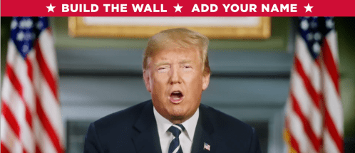
Donald Trump’s most astounding victory–predating and perhaps enabling his astounding electoral victory as President–was to remap the mental imagination of Americans, and reconfigure proximity of the United States to its southwestern border in the public imaginary.  The goal of this insistence is no less than a remapping of civil liberties, based on his insistence of the need for border security and constructing a Border Wall, and preferably doing so in all caps.  

Build the Wall--Add Your Name.png

Condemning “obstructionist Democrats” are the party of “open borders,” and obstructing the work of law and order agencies such as ICE–the Immigration and Customs Enforcement–agents or his beloved Border Patrol, and for filling the national need for border security, and the project of building “the wall,” a super-border structure that would both prevent cross-border migration deemed ‘illegal.’  The construction of border psychosis is evident in the large number of Republican governors of states that have been elected two years into the Trump Presidency–

Governors?.png

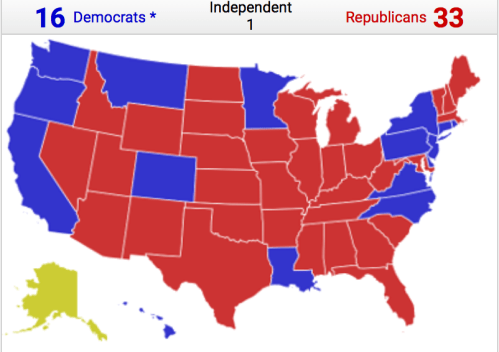
–as the question of “governing” states most all the southwestern border–save California–has created a new “block of red” that has been generalized to much of the nation, rallying behind the America First cry to defend borders, build prisons for immigrants deemed illegal, and work with federal agencies to apprehend such immigrants, denying their lawful place or rights to work in the United States.  For much of this map of governors, now that the Republican party is increasingly the Party of Trump, reveal the uncertain terrain of the undocumented immigrant, and the massive circumscription or reduction of human and civil rights, as well as a fear of failure to manage immigration.  Although current findings of sixty-nine competitive districts in the 2018 election include many border states–sixty-three districts of the total are held by Republicans before the election, a considerable number of the “battleground states” lying near or adjacent to the planned Border Wall, according to a Washington Post-Schar School survey

Sixty Nine Competitive Congressional district.pngWashington Post

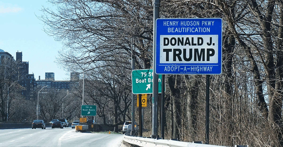
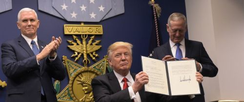
–where calls for wall-building originated.  The magnification of the border in the electorate’s collective consciousness was a gambit of electoral politics and staple of the Trump campaign for the Presidency, and it conjured the unprecedented idea that a single President–or any office-holder–might be able to shift the borders of the nation, or guarantee their impermeability to foreign entrance.  The striking appeal of the border was not seen as a question of border protection but rather the construction of a wall, evident in the expansion quasi-tribal collective rhythmic changes at rallies, now repeated as if in a non-stop campaign.  Although the focus of most buildup of the border has been to update existing fencing, the calls for fix-it-all border protection plans gained sufficient appeal to suggest a potential shift in the nation’s political terrain.  Even though Donald J. Trump was, for practical purposes, a quite parochial perspective based in New York and Manhattan, and perhaps because Trump’s own expertise in national building projects was as limited as with working within the law, the project was first floated by the candidate as if from the sidelines of national politics, treating the project as akin to protecting a two-mile southbound side of the Henry Hudson Parkway in Manhattan, beside his pet real estate project, Trump Place, at 220 Riverside Drive, through an Adopt-A-Highway Project, and that the border wall was essentially the same need of securing .  (Although the prominent sign was itself quickly vandalized to read “STOP TRUMP”  as Trump won the Presidency, needing to be replaced, the return of the defaced sign promising the riverfront side’s maintenance was far less an act of good citizenship than a vanity act.)

Jon Comulada/Upworthy

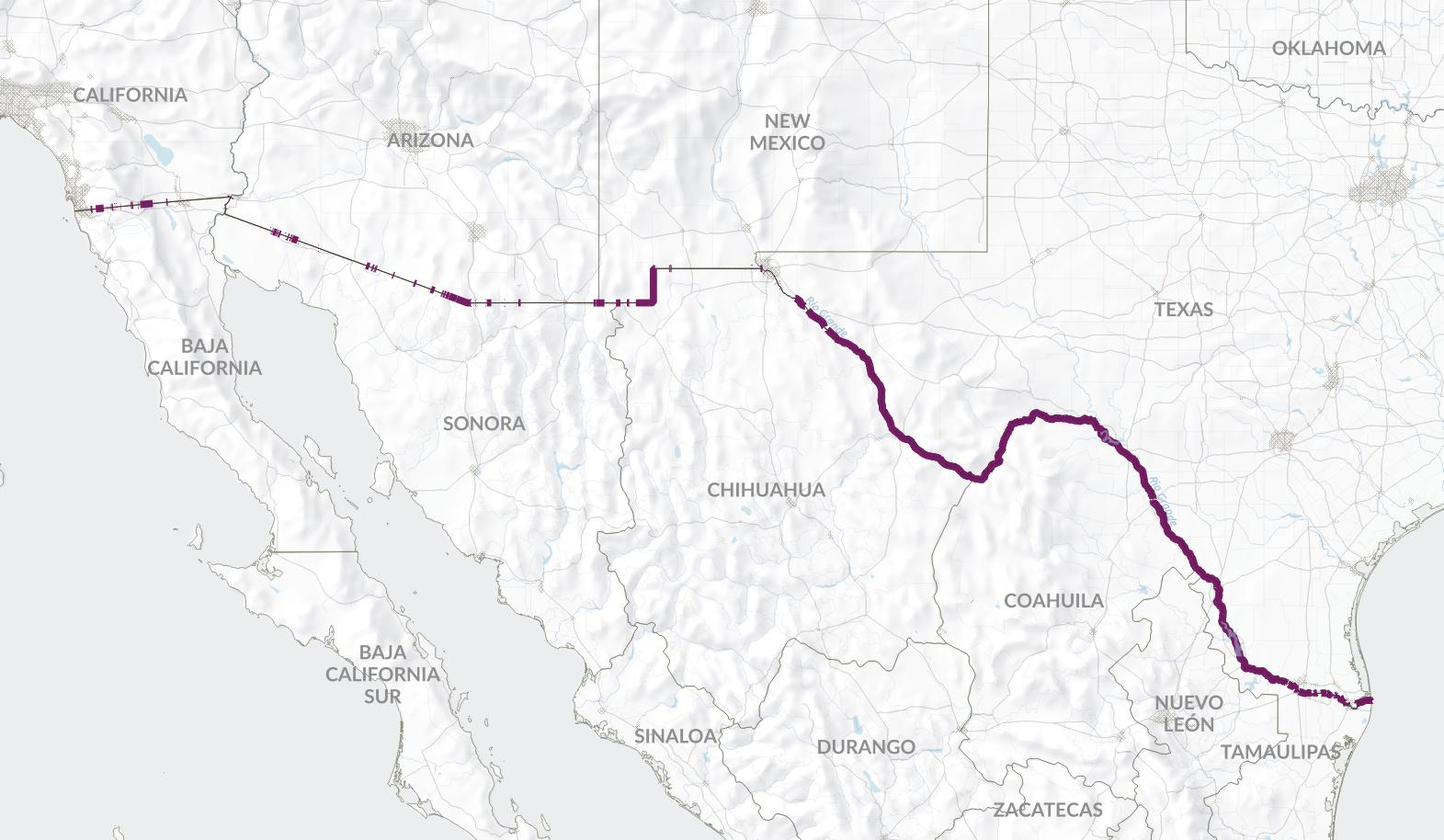
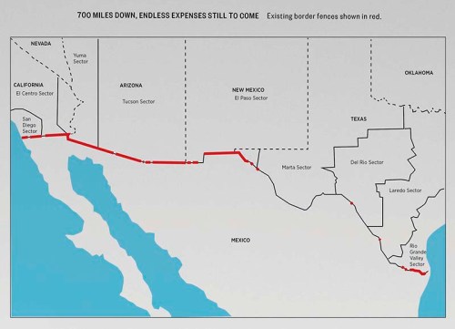
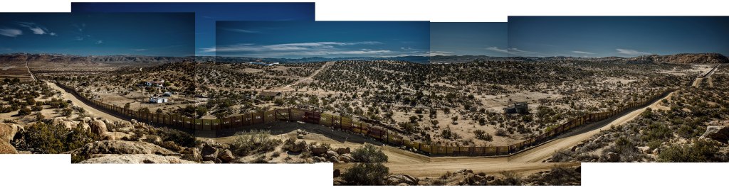
New York City limits the Adopt-a-Highway program to individuals, companies or organizations, rather than to political candidates and campaigns seeking publicity, but since the Trump Organization maintained the section since 2007 or earlier, it gained an exemption–and a tax write-off for its contributions to maintenance.  And when he spoke to residents of the territory currently known as “America,” Trump seems to have treated the proposed Border Wall as an almost similar project of beautification, and a project of protecting what was his, in a proprietorial way that seemed to conflate his own identity and person with the country, as the current sign conflates his name with the Trump Organization, as his recommendations have contained as little familiarity with the site, scope of the project, or terrain, as many have noted, treating the construction of a continuous border wall as a detail designed to beautify the country, even though the border includes 1,288 miles currently without any pedestrian or vehicular fencing, gate or protection.

Reveal

It almost seems that the proposed border wall had not been “mapped” per se, so much as it was a rhetorical promise for the sort of project Trump would like a President to do–and a project whose magnitude appealed to his sense of personal vanity.  He praised the benefits of the construction of the wall as a need to “get it done” and imperative that responds to a state of emergency–a national emergency that sanctioned the suspension of existing laws.  The emergency, as Trump saw it, was created by crime, gang violence by MS-13 members, who he has called “animals,” and a source for a loss of low-wage jobs.  The acknowledgment of the need for the wall is virtually a form of patriotism in itself; recognition of the need for the country has become a way to participate in a new nationalism of strong borders–a nationalist sense of belonging that was opposed to the agenda of those unnamed Liberals without clear purchase on the geopolitical dangers and a failure to put America First.  President Trump has argued that the “larger context of border security” necessitates the wall.  Trump has come to repeatedly proclaims in his continued rallying cry stake out a new vision and map of American sovereignty, and indeed of territorial administration.  Evoking a new tribalism in openly partisan terms, Trump even promoted with impunity the false belief that Democrats have united behind an “Open Borders Bill,” written by Dianne Feinstein–distorting the #EndFamilyDetemtion protests and “open borders movement” with an actual legislative bill.  More to the point, perhaps,

The very crude geography and mental mapping that animates this argument is repeatedly a staple of Trumpian rhetoric.  As if  thick red ruled line could be drawn atop a map, Donald J. Trump has become the outsider political voice able, as a builder of vain monuments, to claim the ability to build a new structure able to replace existing border fences, and provide a continuous monument at endless concealed costs, without any acknowledgement of the people who have long moved across the border on the ground.   The transposition of this tribalism of border separation into a partisan dichotomy has promoted and provoked an apparently Manichean opposition between political parties around the defense of the US-Mexico border, and the building of a Border Wall, in an attempt to define the differences between Democrats and Republicans around the issue of the defense of national safety.

Bier3a

President Trump has not only made immigration into a platform for his campaign and for his party:  the stubbornly intransigent logic of Trump’s oppositional rhetoric has not only remapped the nation in mind-numbing ways.  The fixation on the fixity of the border as a means to “Make America Great Again” erases the historical instability of borderlands in the United States, in its place projecting the image of fixed boundaries:  the exact shift in the image of national territoriality seems a not only shift on the border, but a decisive replacement of an inclusive state.  And even as Trump’s recent rallies are–as of September–still interrupted by “Build that wall!” tribal chants, leaving Trump to lie openly by claiming “The wall is under construction,” he reminds us of his need to evoke an inexistent barrier for which such intense desire has developed among his supporters that it is indeed a talisman by which America will, indeed, be able to be Made Great Again.

Continually crying about the urgent need for “building the wall,” even if it would be in violation of international law, is cast as a state of emergency which would reduce crime, the illegal presence of gangs, and existential dangers, and a promise made without acknowledgement of any who live outside America’s national borders, or any foundation in civil law.  The promise to finish “building the wall” is cast as a simple question of volition, in almost pleading tones, that can be addressed to the entire nation as an ability to cathect and commune with the nation in simple concrete terms, no matter the distance at which they live to the actual border.  It is an exercise in the geographic imaginary, in short, and a nearly ritualized deceit which Trump labors to sustain–as if a Border Wall could be conjured into existence as a leap of faith.

Identifying the dangers to the nation as lying external to it, the discourse of the wall have created a subtle remapping of sovereignty, on an almost emotional level.  It focusses on the border, as an imagined line, rather than on people who move across it, laws or citizenship–placing demonized dangers as lying beyond the border and outside of the nation-state.  The disproportionate focus that has been directed to the border–a distortion of attention that is epitomized and focussed on the desire for a continuous “border wall”–functions as a deeply dehumanizing way of remaking the nation, and remapping national priorities, around a fiction and a distinctly new discourse on nationhood, that is mapped by vigilance to the border, rather than to the course of law or to individual rights and liberties.

If maps provided tools for defining and symbolizing nationality, the conceit of the need for a border wall symbolized and also creates a notion of nationhood based less on ties of belonging than on boundaries of sovereignty that exclusion people from the state.  Mapping is long based on ties of exclusion.  But the focus of intense attention on stopping border-crossing and transborder permeability as replaced a logic of maintaining protections on equality or access to the law in the interior, shifting the attention of the nation of spectators by a deeply cruel trick of remapping the nation’s priorities.  For the political rhetoric of creating a fixed border has effectively magnified the borderlands, through the terribly exaggerated violent pen-stroke of an Executive Order casting the border as a vital key to national security, and increase the proximity of the nation to the southwestern border in the political spatial imaginary.  

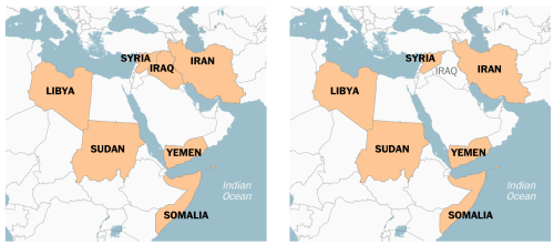
Is it any coincidence that the same government to elevate the symbolic mapping of a wall on the southwestern boundary of the United States has reduced the number of refugees that it agrees to admit from war-torn lands, already reduced by half through executive orders from the number of refugees accepted in 2016, a limit of 45,000, to a new ceiling of “up to 30,000 refugees” beyond “processing more than 280,000 asylum seekers,” in line with the current 2018 count of barely over 20,900 by mid-September, but now for the first time less than the number accepted by other nations.  Turning a cold shoulder to the crisis in global refugees is ostensibly rooted in a responsibility to guard its own borders, and “responsibility to vet applicants [for citizenship] to prevent the entry of those who might do harm to our country” and reducing grounds for asylum–even as the numbers of global refugees dramatically escalate dramatically world-wide–as if intentionally setting up obstacles for travel, and setting policy to openly prosecute any cross-border travel that was not previously authorized, and actively separating many asylum seekers from their families to deter them from pursuing asylum.

refugee_flow_map-africa

New York Times

Such false magnification of problems of “border management” has defined a disturbing and false relation to a deeply distorted image of globalism, of fuzzy borders, and not only apparent but intentional distortion–

image.pngAFP/Getty Images

–predicated on a false sense of national vulnerability, the urgency of greater border security, and the definition and elevation of national interests above global needs.

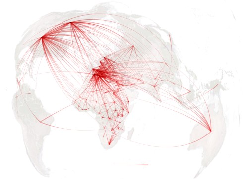
The rejection of refugees and closing of borders in the United States in the Age of Trump seems endemic:  if the country resettled some three million people since 1980, when modern refugee policy began, this year, the United States for the first time fewer resettled refugees than the rest of the world–less than half as many as the rest of the world.  The shuttering of borders is echoed in some 800,000 cases for asylum awaiting review, revealing a distorted view of the global situation that is mirrored by the blurred map behind Mike Pompeo’s head, and may suggest a global irresponsibility and deliberate disentanglement from world affairs.  But it also suggests a deep remapping of the place of the nation in the world, not limited to the State Department or Mike Pompeo, of imagining the greater proximity of the borderline to the mental imaginary, and a privileging of so-called sovereign rights over pathways of human flow.

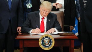
The promised wall planned for the border of unscalable height is a bit of a blank canvas designed to project fears of apprehension onto those who would confront it, a barrier to prevent motion across the border by unilaterally asserting the lack of agency or ability to cross a line that was long far more fluid, in a sort of sacred earth policy of protecting the nation’s territory along its frontiers–and refusing the extend rights or recognition to those who remain on its other side.  Trump’s signing of grandiose Executive Orders as statements of sovereignty stand to reverberate endlessly in our spatial imaginary of the nation–while hardly warranted as a form of national defense, the border wall serves as a phatic act of sovereignty that redefines the function of national bounds.  Indeed, in a country whose history was defined by the negotiation of borderlands, the assertion of the long unstable border as an impermeable barrier seems a form of willed historical amnesia, as well as the fabrication of a non-existent threat.  The repeated indication of the southwestern border seems to seek to restore it to prominence in our national consciousness–and to see its security as being linked to the health of our nation–as if to make the current project of re-bordering an improvement of our national security–a process of re-bordering that is a performance of sovereignty, simultaneously symbolic, functional, and geopolitical in nature.  

The symbolic of sovereignty is far more insistent than the functional, and the symbolic register is the heart of its political meaning, if the structural need is promoted as a response to geopolitical actuality.  

gty-donald-trump-order-cf-170127_12x5_1600

170125134602-01-trump-executive-order-immigration-0125-medium-plus-169

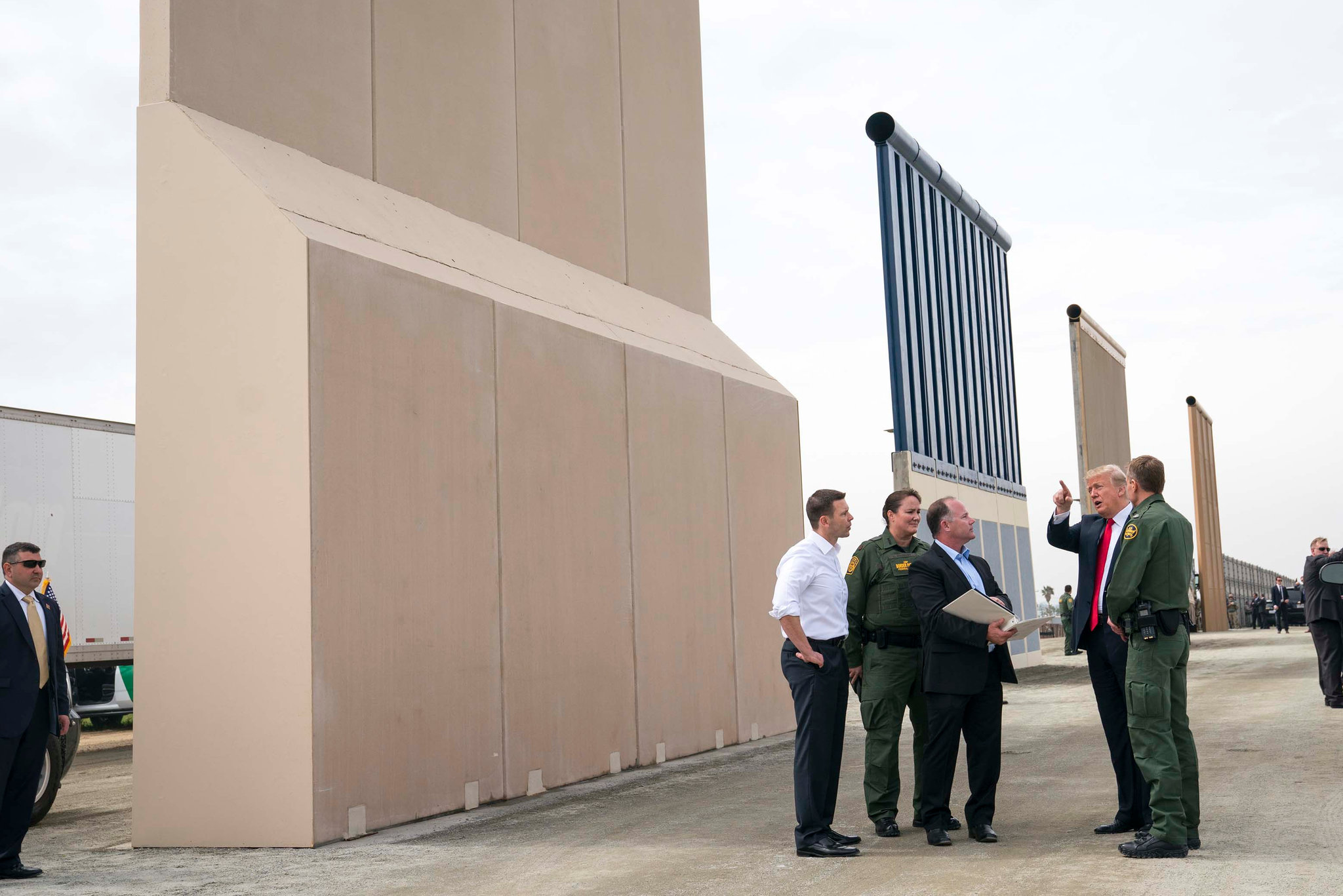
For the Trump train, the wall is a “smart” redefinition of the nation, rooted less in the accordance of civil rights or guaranteeing of human rights, than the subsuming of law to protection of a nation that we imagine as under assault.  If globalization has been understood as a process of “re-bordering,” where the lines between countries are neither so fixed or so relevant to political action on the ground, the border wall maps a defense against globalization in its rejection of open borders.  The proposed construction sets a precedent as an act of unilateral border-drawing, or willful resistance to re-bordering, by asserting a new geographical reality to anyone who listens, and by cutting off the voices of those powerless to confront it.  The deeply dehumanizing conceit of the border wall that was modeled in several prototypes deny the possibility of writing on their surface.

In ways that mirror the inflation of the executive over reality or the rule of law, the border wall serves to reinstate an opposition over a reality of cross-border migration.   And Trump seems particularly well-suited and most at home at this notion of reordering, which he has made his own as a construction project of sorts, where he gets to perform the role of the chief executive as a builder, as much as a politician or leader of a state, and where he gets to fashion a sense of sovereign linked to building and construction, to a degree that the builder turned political seems to be intensely personally invested and tied.  Although Trump has been keen to treat the notion of a border wall as a form of statecraft, the proposed border wall is all too aptly described as a an archaic solution to a twenty-first century problem–for it projects an antiquated notion of boundary drawing on a globalized world in terrifyingly retrograde ways.  For while the construction of the border wall between Mexico and the United States was mistakenly accepted as a piece of statecraft that would restore national integrity and define the project and promise of the Trump presidency to restore American ‘greatness’ rooted in an illusory idea of privilege, but focusses on the privilege of entering the sovereign bounds of the nation alone.  

The proposed wall maps a dramatic expansion of the state and the executive that continues the unchecked growth of monitoring our boundaries to foster insecurity, but creates a dangerously uneven legal topography for all inhabitants of the United States.  For Trump and the members of his administration have worked hard to craft a deeply misleading sense of crisis on the border that created a stage for ht border wall, and given it a semantic value as a need for an immigration “crack-down” and “zero tolerance policy” that seem equivalent in their heavy-handedness to a ban, but have gained a new site and soundstage that seems to justify their performance.  

While it is cast as a form of statecraft, the only promise of the proposed border wall is to exclude the stateless from entering the supposedly United States, and to create legal grounds for elevating the specter of deportation over the country.   For the author of the Art of the Deal used his aura to of pressing negotiations to unprecedentedly increase the imagined proximity of the entire nation to the border–by emphasizing its transactional nature in bizarrely in appropriate ways.  The result has undermined distorted our geographical and political imaginary, with the ends of curtailing equal access to due process, legal assistance, and individual freedoms.  Acceptance of the deeply transactional nature of the promise of a border wall during the 2016 Presidential election as a tribalist cry of collectivism–“Build the Wall!”–as an abstract imperative, removed from any logic argument, but rooted in a defense of the land.  The purely phatic statement of national identity was removed form principles of law, but offered what seemed a meaningful demand of collective action that transcended the law, either civil law, to affirm an imaginary collectivity of Americans without immigrants–and an image of a White America.  

The imperative exhortations that animated Trumpism, as it gave rise to multiple other inarticulate cries repeated on Twitter and at rallies, based on lies and false promises or premises–“Lock her up!”; “America First!”–fulfilled a need for membership and belonging at the expense of others, in ways that subtracted popular opinion–and a false populism of the Trump campaign–from the law.  By isolating the artifact of the wall as a sort of grail and site of redemption and religion of the nation, the tribalist cry “Build the Wall!” offered a false imperative that replaces reasoned discourse.   Trump sees fit to treat as a basis for shutting down the government, accordingly, and indeed as a logic for a brand of governing that doesn’t follow the “terrible laws” of his predecessors.  If the budgeting of a border was was earlier taken as a grounds to actually shutter the government, in 2017, the rehearsal of the threat to willfully “‘shut down’ government if the Democrats do not give us the votes [for] the Wall” once more unnecessarily equated the need for the border wall as a basis and rationale for government.  The Manichean vision of politics of a pro- and anti-border party has been determining in creating a vision of the United States where sovereignty is defined at the border, irrespective of responsibility for the stewardship of the country:  we built walls, impose tariffs, and end treaties, rather than acting in a statesmanslike fashion, and evacuate the promise of the state.  

Much as Trump earlier called for “a good border shutdown” in the Spring of 2017 cast the wall as a part of his notion of governance, the new threat treats the as a bargaining chip able to equate with an act of governance–even if the wall as it is described seems less about governance at all.  Trump rails against the passing of spending bills that do not foreground or grant a prominent place to the proposed border wall that he sees as a point of orientation needed for his constituents and that he still cherishes and his own introduction into national debate:  attacking legislative packages about spending bills that don’t include special stipulations for border security or the construction of a border wall, threatening on Twitter to suspend governmental functions altogether without knowing “where the is the money for Border Security and the WALL in this reicidulous Spending Billaon the eve of the arrival of an apporopriations bill to the White House in the Fall of 2018, as his executive functions seem as imperilled as his grasp on the Executive Branch,  of government: but the border wall retains centrality as the central promise he has made to the nation.

For the unwarranted and ungrounded promise to prevent the imagined threats of organized criminals, gangs, rapists, and drug dealers from entering the country–not that we lack many who are home-grown–through the border wall is a governance of exclusion, racial defamation, and promotion, which has little to do with governing at all.  The apt characterization of the border wall as being an inefficient and irrational fourteenth century solution to a twenty-first century problem by Texas U.S. Representative Henry Cuellar-D of San Antonio–riffing on the suggestion of U.S. Representative Will Hurd-R of San Antonio as a third century solution to a twenty-first century problem ineffective to secure cross-border migration, and gesturing to the new tribalism that the project affirms.  The imperative of the border wall is an insistence of tribalism over civil society, and a reflection of the increased tribalism we feel and see, but mostly feel and fear.  Indeed, it allows these fears to be mapped against cross-border traffic.

The imperative distorted and magnified what a border is and should be that shows little understanding of effective governance, and reclaims an old idea of the border–a fantasy, at root–that rejects the permeable nature of borders in an era of globalism, by rather affirming an imagined collectivity from which dangers–unspecified, but ranging from gangs to drugs to child trafficking–must be kept out.  Although an underlying problem is POTUS’ spectacular lack of understanding of how government works, or of the law, which he has spent most of his life reinterpreting, it reveals his conviction construction contains crisis in essentially fascistic terms, building a structure that has little contextual meaning, but seems to impress, as a negative monument to the the state that is located in a borderland of apparent statelessness, but which Trump seems more and more frustrated at his actual inability to change what still looks more like a rusting twelve-foot tall Richard Serra sculpture than the imposing frontier promised America–

imageRichard Serra, Tilted Arc (New York City, Federal Plaza, 1981-89)

–but whose offensiveness disturbs, upsets and angers the viewer in a truly visceral way. Resting on the edges of our own borders as the basis for a larger “border complex” that seems to steadily expand, the border complex is not only a unilateral dictation of border policies, but a relinquishing of any responsibility of governance of the inhabitants of the nation, treating the definition of citizen/non-citizen as a primary duality never explicitly adopted as central in American politics and history, but assigning this division a centrality rarely so clearly geographically expressed as a question of national territory.  

Even though the wall is a practical separation between territories, and an assertion of exclusive territorial identity, the imperative of the border wall that is repeatedly cast in urgent, existential terms, has presented itself in discursive terms both as a promise to the nation, in terms analogous to the Contract with America, that separated Americans from others, but which promised to strengthen Americans’ relation to the rest of the world.  The increased proximity of the nation’s inhabitants to the border and border wall was asserted in the Trump campaign:   the transactional status of the wall grew as a means to prevent multiple forces from endangering “our communities’ safety” as the border wall became a narrative plug-in for something like a promise of redemption from higher wages, untold economic dreams, and an acceptance of police security, as if a border can radically change the status quo of the American economy and local family safety.   The proposal of the border wall continues to exist in a deeply transactional sense for Americans, as geographic relations to the actual border has been erased so thoroughly for the border, under the guise of “immigration,” to become a national platform of a political party, and a new model to define and remap America’s relation to the world.

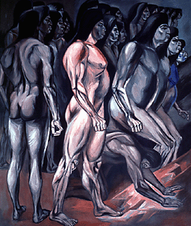
1.  The growth of global insecurity echoes profound anxiety at the realization that the lines of control of states cannot be so legibly or clearly mapped in the present moment, an anxiety it reflects by proposing to inscribe the border onto the landscape to make it visible to all and permanently fixed.  The false promise of the border wall has been able to gain meaning on an individual level, allowing each to invest it with meaning and feel proximity to, independent of their own actual geographic proximity–even if the result is to silence the violence that the proposition of such a border wall does to the rule of law.  If the long and energetic tradition of public mural painting that had origins in the Mexico of the 1930s provided a movement of energetic and energized monumental painting on open air surfaces in projects of humanity and considerable color.  But the elevation of their pictorial formal power moreover asserted a new public identity of the nation for observers.  In contrast, the artlessness of the empty screen of the border wall is an evacuation and denial of subjectivity:  the defining characteristic as a concrete surface of the proposed border wall is itss inexpressive surface, its denial of common humanity, and its assault on the collective narratives that were the subject celebrated in muralism.

The wall stands as a sort of rebuttal to a muralist tradition of inclusiveness–embracing varied styles from Rivera to Siquieros to Orozco–through the assertions of a new artistic idiom by which to involve viewers in a revitalized broad civic life.  The border wall is less an illustration of human will, than an image of the assertion of the reason of the state, understood less by legal principles than a tortured logic of exclusion.  For while the extant border was a site of recuperation of muralist public art, the new border wall serves to impose the fixity of the border as a site that offers no place to the individual refugee, migrant, or legal immigrant, but a blank canvas that symbolizes the absence of individual autonomy or subjectivity to cross the transborder space.  Indeed, rather than a collectivist statement of unity, whose monumental forms suggest a human struggle of collective identity and work, the construction of the wall is presented as a testimony of the need for an obstruction of the passage across the border to protect the nation, based on the knowledge and experiences of border communities, presented as a need to ensure and defend safety, national integrity, and economic power.  Like the symbolic language of muralism offered a replacement for the common iconography of sacred art, in its assertion of public identity, the border wall presents itself as nothing less than a new religion of the state.  While the comparison of the proposed border wall to the public panting of collective art muralism intended as an call to collective national consciousness and unity in post-revolutionary Mexico is a provocative comparison to the elevation of sovereign authority over the border by building a wall, the magnification of the border by the project and prospect of building a border wall has served to elevate a perilous image of nationhood, based less on ties of commonality, collective identity, or a rich historical legacy of individual involvement that muralists proposed than an unhealthy focus on the border as a site of danger, a frontier needed to be vigilantly guarded, and a threshold whose guarding substitutes for the defense of civil laws.

For in claiming to protect and secure the nation, the border wall becomes a performative exercise of the religion of the state, as much as it serves as a defense of political sovereignty.  The authority of the US-Mexico border wall, in unintentionally, seems to stand as an open rebuke and rebuttal to the hopeful ideals and huge figures in images of dynamic abundance such as the monumental Allegory of California (1931) by which Diego Rivera depicted the rich bestowal of gifts on of a heroic mother earth figure of California, in San Francisco, whose monumentalism addressed individual viewers by an almost tangible allegory of local abundance —

photo-2_rivera

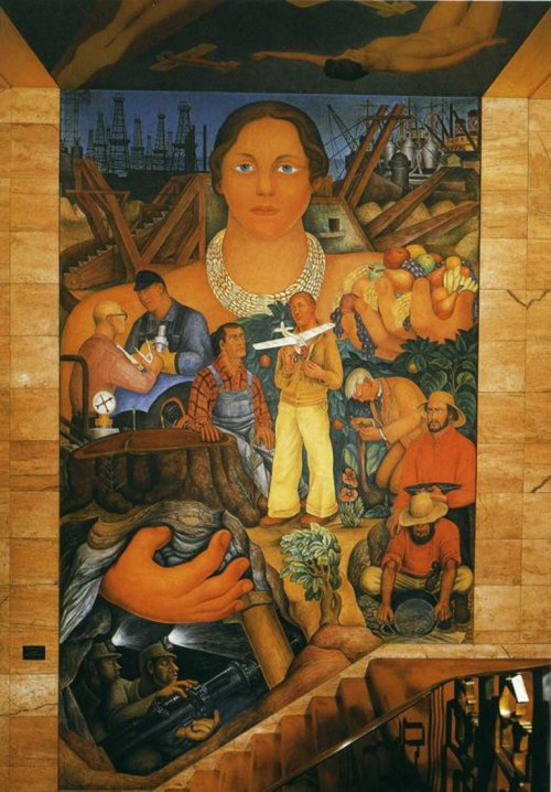
–which set a basis, in one of the first large projects of the painter in the United States, set a basis for a new tradition of public moralism in western states.  The interchange between active labor, earth, and a united countryside, if not a united narrative of nation, offered an optimistic personification of a monumental Gaia-like state, who, her resources liberated by workers, grants “gold and fruit and grain for all” of its residents, the revolutionary art of Siqueiros that heroized his country, or the twined histories of the Americas that José Clemente Orozco organized of tragic but truly epic historical scope of the Ancient Migration and the Migration of the Human Spirit, extending the collectivist spirit of revolutionary nation.  Affirming a discourse of white privilege, indeed, rather than inclusion, the border wall is an imperative of religion of the nation that girds the border as a sight of defense, mapping the other as outsider in relation to the needs of the state, rather than celebrate the human subject as a force that is part of nature or culture. Rather, the proposed border wall seems to exist outside culture or nature, as an imperative to an endangered and threatened civility of the status quo.

The border wall erases the spirit of the migrant as it prevents migration, alleging compelling reasons of state and the new logic of the religion of the nation that replaces the law and any appeal to the law in its urgency.   Rather than portray a giving sense of the heroism of migration, indeed, the wall interrupts any freedom of migration and transborder or transnational citizenship, reducing citizenship to a notion of territoriality and land, by bounding the terrain of citizenship and affirming a new ordering of space, and a political theology about the boundaries of the state, and the subtraction of citizenship or rights from the “enforcement zone,” “border zone” or denial of the rights of political representation or legal status for all transnational migrants in the “dead zone” of the borderlands.   The absence in this zone of rights of the subject–the refugee, migrant, or itinerant subject–is paramountly defined by their statelessness and inability to fit between strict categories of sovereignty, rather than motion across states being celebrated as a point of access to the bounty of the land, or of the migration of the spirit as a celebration of the recuperation of a modern individual political identity.  By demonizing the practice of migratory mobility, as if by a principle of “earth-first” binding of the nation, the border inverts the celebration of the human spirit

panel1

panel21Jose Orozco, Migration of the Modern Spirit (panels 1 and 21) (Dartmouth University)

There was a resurgence of the discursive practice of the political messages contained in  muralism as a form of public art in the resistance to decorating the border with monitory signs.  Is the Border Wall not only a map, but also a rebuttal to this tradition, and indeed to the painting of public rebuttals to the wall through paintings and commemorations in the past?  The absolute absence of any affect or visual address within the intentionally blank, sterile and almost industrial character of the wall seems in hidden dialogue or rebuke of an aesthetic of direct involvement of the viewer through its mute surface and corresponding evacuation or denial of individual human rights.  

1.  The triumph of industry, of rich historical cultures, or even of cultural conquest and revolutionary violence is compellingly replaced by the absence of any trace of human making or creation–or individual subjectivity–within the surface of the proposed border wall, which rather stands to deny individual liberty:  in place of an aesthetics of broad political involvement, the denial of the presence of those on the other side of the border wall stand as a vicious act of disenfranchisement, and even a denial of human subjectivity.  Indeed, if the heroic or epic narratives of monumental figures engage viewers in a pedagogic manner in muralist traditions by illustrating a narrative of nation, the proposed wall suggests a blunt lack of any national narrative, save the denial of the subjectivity of those on the other side.

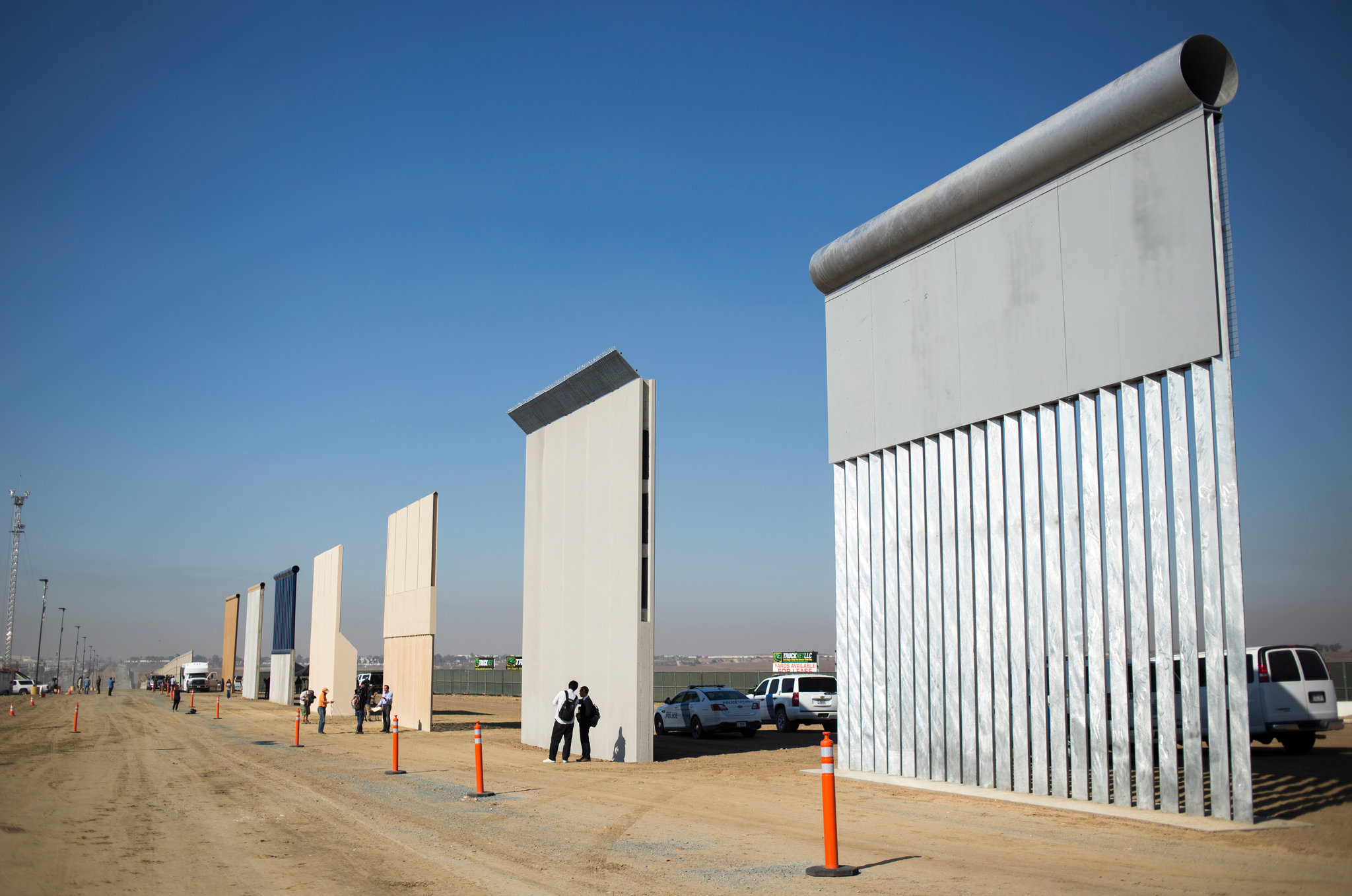
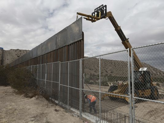
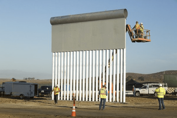
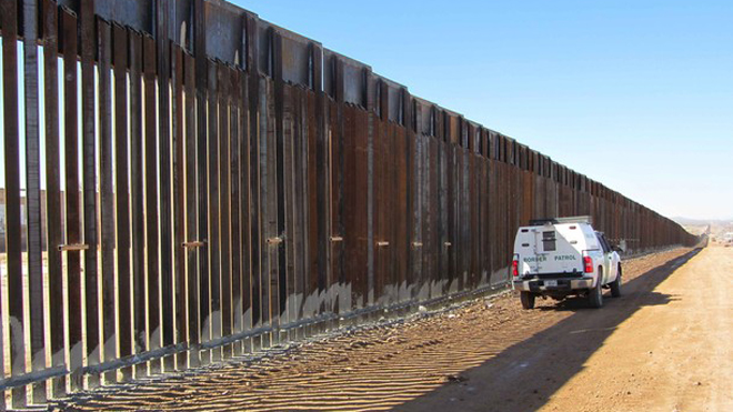
The talismanic nature of these “prototypes”–mock ups slightly removed  the border–was meant to evoke the prominent place of the border wall, and to restore or reinforce  in the psychological and mental imaginary of our new national space.  Repeated throughout the Presidential campaign as if a mantra, evocation of “the promised wall on the southwestern border” has redefined a relation to the nation–and indeed been presented as a form of love for the nation–by the master builder who would be US President.  And although the request for a “solid, Concrete Border Wall” in March, 2017–described as the President’s building medium of choice–became a secret state project, as “too sensitive” to be released by a Freedom of Information Act, by the Department of Homeland Security, designed to meet demands to be impossible to tunnel under, and impenetrable to sledgehammers or other battery-operated electric tools for at least an hour, seem something of a simulacrum of the state that is both all too obstructive for actual migrants and cherished by many Americans, and prevents the transformation of previous parts of the border wall to public sites of commemoration–remembering the suffering of those who attempted safe passage, or indeed of mural-art that has attempted to assert the fluidity of cross-border transit.

CrossesAguaPrieta--Dec08

gettyimages-632717318.jpgSandy Huffaker/Getty Images/Palm Beach Post

–or that try to imagine the perspective that the future of the border wall will create for the migrant subject who is excluded from hopes of cross-border transit.

Trump Vows To Build Border Wall Between Mexico And The U.S.Justin Sullivan/Getty Images

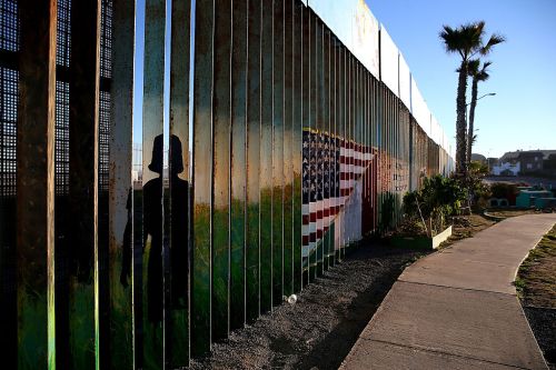
Even as the proposed US-Mexico border wall is presented as girding the nation against multiple dangers, the new bounding of the nation that prevents any intervention or artistic transformation of the wall, by stating its own absolute authority as a re-writing of the nation.  The permanence of the models of the wall seem not so tacitly or subliminally suggested by the physics form of one of the mock-ups, which references the form of a flag, as if to suggest its similar permanence as can image and record of the nation, and proof of the nation’s continued existence, as if the nation could not exist without it:  indeed, the flag-like proportions in mock-ups suggests a new flag for the nation.  As the promise of the border wall has allowed such a range of audiences to cathect to the national boundary–a sense that was perhaps predicted in the repainting of a section of the existing border wall of welded metal and steel near San Diego–the very site where a caravan of Central American migrants would arrive where they were taken by President Trump as an illustration of the fear of the dangers of cross-border immigration–the wall suggested a sort of surrogate for the purification of the country, restoration of the economy, and an elevation of the minimum wage, wrapped into a poisoned promise of poured concrete.

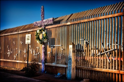
It was no surprise that a group of Mexican-American veterans chose to paint a segment of the older wall near Tijuana in 2013 as if a mural that mirrored the use of the inverted flag to stage a signal of distress to the nation:  indeed, the deported former navy who chose the wall as a site for a cry of emergency and national belonging:  teerily prescient of the flag-like nature of the mock-ups, sections of which uncannily resemble a vertically hoisted flag, the wall sections painted by disabled veteran Amos Gregory, a resident San Francisco resident, who completed the painting with twenty deported veterans, recuperated the tradition of moralism to create a new story of the wall, where crosses of dead migrants replaced the stars of the stars and stripes, as if to appropriate the wall to a public narrative of nationhood.

image.png

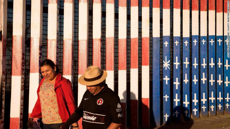
The inverted flag that a group of U.S to paint the flag, but expressed shocked at charges of using an iconography “hostile toward the United States of America,” and chose the inverted flag as a distress signal–to show honor to the flag, and to “mean no disrespect” to the nation, but to raise alarm at its  policies.  His dismay when asked to remove the mural by US Border Patrol sent a message of censorship as an attack on freedom of expression; Gregory incorporated crosses to commemorate on the wall the migrants who died seeking to enter the United States for better lives and livelihoods,  undermining the ideals of freedom he cherished.  By placing their memory on the wall, he sough not to dishonor the flag, but to use it as a symbol of extreme gravity that respects its ideals–and the etiquette of flag display, in the manner  future protests at the marginalization of migrants seeking asylum as they enter the United States at its border zone.

distress at Ptotest

The current mock-ups suggest, if unconsciously, an actual evacuation of patriotic ideals.  The MAGA President might have been conscious of how several of the so-called prototypes suggested a flag turned on its end, as if in a new emblem of national strength–

image.png

–as if to offer them a new symbol of the nationalism of a new nation.  The segment of this prototype recalls the flag suspended vertically, as on a wall or over a door, above the border that has become a prominent character in the current President’s Twitter feed, and evokes the ties between terrorism and immigration that Trump has long proposed the government recognize and acknowledge, despite having few proofs of these connections, acting as an assertion of the implied criminality of all immigrants who do not cross border check points by legal protocol, no matter their actual offense.

1. The compact about the construction of the border wall has, against all probability, become the latest in faux populist promises since the Contract with America to pose fictive contracts of illusionary responsibility and reciprocity to the democratic process, and have provided new tools of assent.  At the deepest level, the wall exists in this discourse of urgency not as a proposition, but as an actuality that need only be built, and cannot–or need not–be mapped, less the practicalities of consequences of its construction by acknowledged.  The border wall, viewed in its prototypes, is somehow an expression of the unmappability and existential quality of the border wall that Trump wants; alien from its surroundings, and existing as an obstacle to entrance, it is a redefinition of the border from a site of passage to an obstruction.  The affirmation of the border as a “real border”–which Trump repeatedly ties to the status of the United States as a “real country”–seems to mean an impassible border, which lacks any negotiation, but is recognized as an element of the nation that needs to spatial location but acts to strip all outsiders of their their rights.  All attempts to map the border as a spatially situated place  seem to stand as a challenge to undo the imperative of the wall’s construction.

The faux consensual ties with the electorate perpetuate a fiction that a democracy runs on the contractual obligations between a government and populace, but have early been so focussed on geographically specific terms.  But in an age of anti-government sentiment, the icon of the wall has become an effective icon of describing the ineffectiveness of prior administrations, and an iconology embodying the new role of the executive in the age of Trump:  in an age of global mapping that seems to disrespect and ignore borders, we imagine migrants moving across them with the aid of GPS, or Google Maps, empowered by the location of border check-points on their cross-border transit,–

Google maps borderGoogle Maps

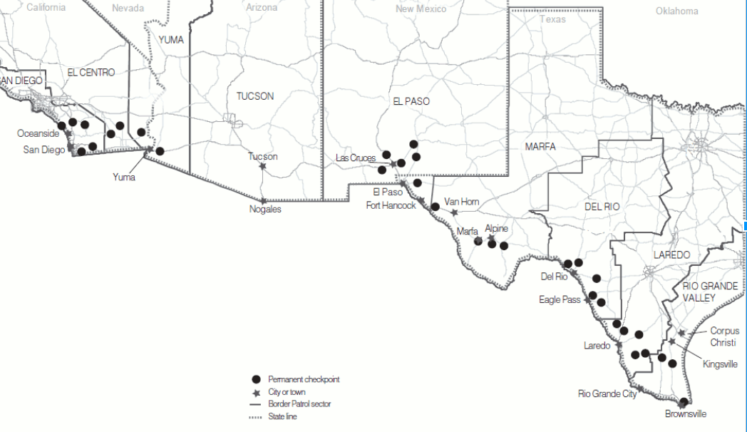
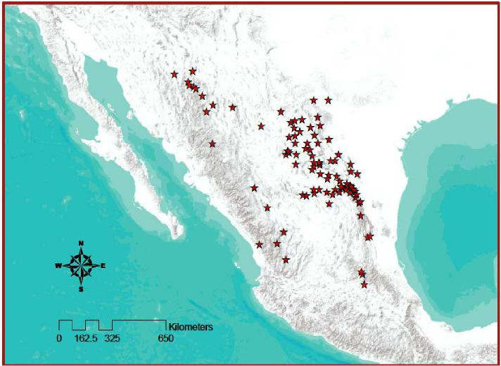
In a rejoinder to these fears, the proposed border wall would map a continuity among the stations in different sectors administered by the US Border Patrol, already strikingly dense, and apparently easy to connect by a solid wall–

Border Checkpoints

1 Comment

Filed under border wall, globalization, human rights, immigration, US-Mexico Border

Mapping Bannon’s Ban

American President Donald Trump claimed that his attempt to prevent visitors from seven countries entering the United States preserved Americans’ safety against what was crudely mapped as “Islamic terror” to “keep our country safe.”  Trump has made no bones as a candidate in calling for a “total and complete shutdown of Muslims” as among his most important priorities if elected President.  The map the he has asked the nation to draw about who can enter the country–purportedly because they are “terrorist-prone” nations–a bizarre shorthand for countries unable to protect the United States from terrorism–as if this would guarantee greater safety within the United States.  For as the Department of Homeland Security  affirmed a need to thwart terrorist or criminal infiltration by foreign nationals, citing the porous borders of a country possessing “the world’s most generous immigration system” that has been “repeatedly exploited by malicious actors,” and located the dangers of terror threats from outside the country as a subject for national concern, provoking anxiety by its demonization of other states as national threats.  And even though the eagerly anticipated “ban” lacks “any credible national security rationale” as governmental policy, given the problem of linking the radicalization of any foreign-born terrorist or extremists were only radicalized or identified as terrorists after having become Americans, country of citizenship seems an extremely poor prognostic or indicator of who is to be considered a national danger.

Such eager mapping of threats from lands unable to police emigration to the United States oddly recall Cold War fears of “globally coordinated propaganda program” Communist Parties posing “unremitting use of propaganda as an instrument for the propagation of Marxist-Leninist ideology” once affirmed with omniscience in works as Worldwide Communist Propaganda Activities.  Much as such works invited fears for the scale and scope of Communist propaganda “in all parts of the world,” however, the executive order focusses on our own borders and the borders of selective countries in the new “Middle East” of the post-9/11 era. The imagined mandate to guard our borders in the new administration has created a new eagerness to map danger definitively, out of deep frustration at the difficulty with which non-state actors could be mapped.  While allegedly targeting nations whose citizens are mostly of Muslim faith, the ban conceals its lack of foundations and unsubstantiated half-truths.

The renewal of the ban against all citizens of six countries–altered slightly from the first version of the ban in hopes it would successfully pass judicial review, claims to prevent “foreign terrorist entry” without necessary proof of the links.  The ban seems intended to inspire fear in a far more broad geography, as much as it provides a refined tool based on separate knowledge.  Most importantly, perhaps, it is rigidly two-dimensional, ignoring the fact that terrorist organizations no longer respect national frontiers, and misconstruing the threat of non-state actors.  How could such a map of fixed frontiers come to be presented a plausible or considered response to a terrorist threats from non-state actors?


travel-ban-trump


1. The travel ba focus on “Islamic majority states” was raised immediately after it was unveiled and discourse on the ban and its legality dominated the television broadcasting and online news.  The suspicions opened by the arrival from Wall Street Journal editor-in-chief Gerard Baker that his writers drop the term “‘seven majority-Muslim countries'” due to its “very loaded” nature prompted a quick evaluation of the relation of religion to the ban that the Trump administration chose at its opening salvo in redirecting the United States presidency in the Trump era.  Baker’s requested his paper’s editors to acknowledge the limited value of the phrase as grounds to drop “exclusive use” of the phrase to refer to the executive order on immigration, as if to whitewash the clear manner in which it mapped terrorist threats; Baker soon claimed he allegedly intended “no ban on the phrase ‘Muslim-majority country’” before considerable opposition among his staff writers–but rather only to question its descriptive value. Yet given evidence that Trump sought a legal basis for implementing a ‘Muslim Ban’ and the assertion of Trump’s adviser Stephen Miller that the revised language of the ban might achieve the “same basic policy outcome” of excluding Muslim immigrants from entering the country.  But curtailing of the macro “Muslim majority” concealed the blatant targeting of Muslims by the ban, which incriminated the citizens of seven countries by association, without evidence of ties to known terror groups.

The devaluation of the language of religious targeting in Baker’s bald-faced plea–“Can we stop saying ‘seven majority Muslim countries’? It’s very loaded”–seemed design to disguise a lack of appreciation for national religious diversity in the United States. “The reason they’ve been chosen is not because they’re majority Muslim but because they’re on the list of countRies [sic] Obama identified as countries of concern,” Baker opined, hoping it would be “less loaded to say ‘seven countries the US has designated as being states that pose significant or elevated risks of terrorism,'” but obscuring the targeting and replicating Trump’s own justification of the ban–even as other news media characterized the order as a “Muslim ban,” and as directed to all residents of Muslim-Majority countries.  The reluctance to clarify the scope of the executive order on immigration seems to have disguised the United States’ government’s reluctance to recognize the nation’s religious plurality, and unconstitutionality of grouping one faith, race, creed, or other group as possessing lesser rights.

It is necessary to excavate the sort of oppositions used to justify this imagined geography and the very steep claims about who can enter and cross our national frontiers.  To understand the dangers that this two-dimensional map propugns, it is important to examine the doctrines that it seeks to vindicate.  For irrespective of its alleged origins, the map that intended to ban entrance of those nations accused without proof of being terrorists or from “terror-prone” nations.   The “Executive Order Protecting the Nation from Foreign Terrorist Entry into the United States,” defended as a legal extension of the President’s “rightful authority to keep our people safe,” purported to respond to a crisis in national security.  The recent expansion of this mandate to “keep our people safe” against alleged immanent threats has focused on the right to bring laptops on planes without storing them in their baggage, forcing visitors form some nations to buy a computer from a Best Buy vending machine of the sort located in airport kiosks from Dubai to Abu Dhabi, on the grounds that this would lend greater security to the nation.


2.  Its sense of urgency should not obscure the ability to excavate the simplified binaries that  justify its imagined geography.  For the ban uses broad brushstrokes to define who can enter and cross our national frontiers that seek to control discourse on terrorist danger as only a map is able to do.  To understand the dangers that this two-dimensional map proposes, one must begin from examining the unstated doctrines that it seeks to vindicate:  irrespective of its alleged origins, the map that intended to ban entrance of those nations accused without proof of being terrorists or from “terror-prone” nations.   The “Executive Order Protecting the Nation from Foreign Terrorist Entry into the United States,” defended as a legal extension of the President’s “rightful authority to keep our people safe,” purported to respond to a crisis in national security.  The recent expansion of this mandate to “keep our people safe” against alleged immanent threats has focused on the right to bring laptops on planes without storing them in their baggage, on the largeely unsubstantiated grounds that this would lend greater security to the nation.

The lack of compunction to attend to the religious plurality of the United States citizens bizarrely date such a purported Ban, which reveals a spatial imaginary that run against Constitutional norms.  In ways that recall exclusionary laws based on race or national origin from the early twentieth century legal system, or racial quotas Congress enacted in 1965, the ban raises constitutional questions with a moral outrage compounded as many of the nations cited–Syria; Sudan; Somalia; Iran–are sites from refugees fleeing Westward or transit countries, according to Human Rights Watch, or transit sites, as Libya.  The addition to that list of a nation, Yemen, whose citizens were intensively bombed by the United States Navy Seals and United States Marine drones in a blitz of greater intensity than recent years suggests particular recklessness in bringing instability to a region’s citizens while banning its refugees.  Even in a continued war against non-state actors as al Qaeda or AQAP–al Qaeda in the Arabian Peninsula–the map of Trump’s long-promised “Islamic Ban” holds sovereign boundaries trump human rights or humanitarian needs.

The ban as it is mapped defines “terror-prone regions” identified by the United States will only feed and recycle narratives of western persecution  that can only perpetuate the urgency of calls for Jihad.  Insisting national responsibility preventing admission of national citizens of these beleaguered nations placed a premium on protecting United States sovereignty and creates a mental map that removes the United States for responsibility of military actions, unproductively and unwarrantedly demonizing the nations as a seat of terrorist activity, and over-riding pressing issues of human rights tied to a global refugee crisis.  But the mapping of a ban on “Foreign Terrorist Entry” into the United States seems to be something of a dramaturgical device to allege an imagined geography of where the “bad guys” live–even a retrograde 2-D map, hopelessly antiquated in an age of data maps of flows, trafficking, and population growth, provides a reductive way to imagine averting an impending threat of terror–and not to contain a foreign threat of non-state actors who don’t live in clearly defined bounds or have citizenship.  Despite an absolute lack of proof or evidence of exclusion save probable religion–or insufficient vetting practices in foreign countries–seems to make a threat real to the United States and to magnify that threat for an audience, oblivious to its real effects.

For whereas once threats of terror were imagined as residing within the United States from radicalized regions where anti-war protests had occurred,  focussed on Northern California, Los Angeles, Chicago, and the northeastern seaboard and elite universities–and a geography of home-grown guerrilla acts undermining governmental authority and destabilizing the state by local actions designed to inspire a revolutionary “state of mind,” which the map both reduced to the nation’s margins of politicized enclaves, but presented as an indigenous danger of cumulatively destabilizing society, inspired by the proposition of entirely homegrown agitation against the status quo:


Guerilla acts of Sabotage and Terrorism in US


Unlike the notion of terrorism as a tactic in campaigns of subversion and interference modeled after a revolutionary movement within the nation, the executive order located demons of terror outside the United States, if lying in terrifying proximity to its borders.  The external threats call for ensuring that “those entering this country will not harm the American people after entering, and that they do not bear malicious intent toward the United States and its people” fabricate magnified dangers by mapping its location abroad.


2.  The Trump administration has asserted a need for immediate protection of the nation, although none were ever provided in the executive order.  The  arrogance of the travel ban appears to make due on heatrical campaign promises for “a complete and total ban” on Muslims entering the United States without justification on any legitimate objective grounds.  Such a map of “foreign terrorists” was most probably made for Trump’s supporters, without much thought about its international consequences or audience, incredible as this might sound, to create a sense of identity and have the appearance of taking clear action against America’s enemies.  The assertion that “we only want to admit people into our country who will support our country, and love–deeply–our people” suggested not only a logic of America First, but seemed to speak only to his home base, and talking less as a Presidential leader than an ideologue who sought to defend the security of national boundaries for Americans as if they were under attack.  Such a verbal and conceptual map in other words does immense work in asserting the right of the state to separate friends from enemies, and demonize the members of nations that it asserts to be tied to or unable to vet the arrival of terrorists.

The map sent many scrambling to find a basis in geographical logic, and indeed to remap the effects of the ban, if only to process its effects better.


travel-ban-trump


But the broad scope of the ban which seems as if it will have the greatest effect in alienating other nations and undermining our foreign policy, as it perpetuates a belief in an opposition between Islam and the United States that is both alarming and disorienting.  The defense was made without justifying the claims that he made for the links of their citizens to terror–save the quite cryptic warning that “our enemies often use our own freedoms and generosity against us”–presumes that the greatest risks not only come from outside our nation, but are rooted in foreign Islamic states, even as we have been engaged for the past decade in a struggle against non-state actors.  In contrast to such ungratefulness, Trump had repeatedly promised in his campaign to end definitively all “immigration from terror-prone regions, where vetting cannot safely occur,” after he had been criticized for calling during the election for “a total and complete shutdown of Muslims entering the United States” until they could “figure out what is going on.”

But the targeted audience was always there, and few of his supporters were likely to have forgotten the earlier claims–and the origins of this geographical classification of national enemies terrifying that offers such a clear dichotomy along national lines.  While pushed to its logical conclusion, the ban on travel could be extended to the range of seventy-odd nations that include a ban against nations associated with terrorism or extremist activity–


totalcountriesensnaredintrumpproposals_ea1d4e4541c1a7fc9ec0d213f172e67e.nbcnews-ux-600-480Nick Kiray/NBC News


–but there is a danger in attributing any sense of logical coherence to Trump’s executive order in its claims or even in its intent.  The President’s increasing insistence on his ability to instate an “extreme vetting” process–which we do not yet fully understand–seems a bravado mapping of danger, with less eye to the consequences on the world or on how America will be seen by Middle Eastern nations, or in a court of law.  The map is more of a gesture, a provocation, and an assertion of American privilege that oddly ignores the proven pathways of the spread of terrorism or its sociological study.

But by using a broad generalization of foreign nations as not trustworthy in their ability to protect American interests to contain “foreign terrorists”–a coded generalization if there ever was one–Trump remapped the relation of the United States to much of the world in ways that will be difficult to change.  For in vastly expanding the category “foreign terrorists” to the citizens of a group of Muslim-majority nations, he conceals that few living in those countries are indeed terrorists–and suggests that he hardly cares.  The executive order claims to map a range of dangers present to our state not previously recognized in sufficient or honest ways, but maps those states in need as sites of national danger–an actual crisis in national security  he has somehow detected in his status as President–that conceal the very sort of non-state actors–from ISIS to al-Qaeda–that have targeted the United States in recent years.  By enacting a promised “complete and total ban” on the entry of Muslims from entering the nation sets a very dangerous precedent for excluding people from our shores.  The targeting of six nations almost exemplifies a form of retributive justice against nations exploited as seats of terrorist organizations, to foment a Manichean animosity between majority Muslim states and the United States–“you’re either with us, or you’re against us”–that hardly passes as a foreign  policy map.

Rather than respecting or prioritizing human rights, the identification of Islam with terrorist organizations seems the basis for excluding citizens and nationals of seven nations who might allow “foreign terrorist entry.”   The ban was quickly noted that the list of nations pointedly excluded those where Trump did or pursued business as a businessman and hotelier.  But while not acknowledging this distinction, it promotes a difference between “friend” and “enemy” as a remapping of threats to the nation along national lines, targeting nations not only as suspicious sites of radicalization, but by collectively prohibiting their residents and nationals from entry to the nation.  While it is striking that President Jimmy Carter had targeted similar states identified as the nations that “have repeatedly provided support for acts of international terrorism” back in 1980–President Carter cited the long-unstable nations of  Iraq, Libya, South Yemen, and Syria, following then-recent legislation indicating their abilities “support acts of international terrorism.”  The near-identical mapping of terror does not exemplify an egregious instance of “mission creep,” but by blanketing of such foreign nationals as “inadmissible  aliens” without evidence save “protecting the homeland” suggests an unimaginable level of xenophobia–toxic to foreign relations, and to anyone interested in defending national security.  It may Israeli or Middle Eastern intelligence poorly mapped the spread of growing dangers.

But it echoes strikingly similar historical claims to defend national security interests have long disguised the targeting of groups, and have deep Cold War origins, long tied to preventing entrance of aliens with dangerous opinions, associations or beliefs.  It’s telling that attorneys generals in Hawai’i and California first challenged the revised executive order–where memories survives of notorious Presidential executive order 9006, which so divisively relocated over 110,000 Japanese Americans to remote areas, the Asian Exclusion Act, and late nineteenth-century Chinese Exclusion Act, which limited immigration, as the Act similarly selectively targets select Americans by blocking in unduly onerous ways overseas families of co-nationals from entering the country, and establishes a precedent for open intolerance of the targeting the Muslims as “foreign terrorists” in the absence of any proof.

The “map” by which Trump insists that “malevolent actors” in nations with problems of terrorism be kept out for reasons of national security mismaps terrorism, and posits a false distinction among nation states, but projects a terrorist identity onto states which  Trump’s supporters can take satisfaction in recognizing, and delivers on the promise that Trump had long ago made–in his very first televised advertisements to air on television–to his constituents.


trump-ban-on-muslimsfrom Donald Trump’s First Campaign Ad (2016)

Such claims have been transmuted, to members of a religion in ways that suggest a new twist on a geography of terror around Islam, and the Trump’s bogeyman of “Islamic terror.” Although high courts have rescinded the first version of the bill, the obstinance of Trump’s attempt to map dangers to America suggests a mindset frozen in an altogether antiquated notion of national enemies.  Much in the way that Cold War governments prevented Americans from travel abroad for reasons of “national security,” the rationale for allowing groups advocating or engaging in terrorist acts–including citizens of the countries mapped in red, as if to highlight their danger, below–extend to a menace of international terrorism now linked in extremely broad-brushed terms to the religion of Islam–albeit with the notable exceptions of those nations with which the Trump family has conducted business.

Bloomberg

KSIBIl5


The targeting of such nations is almost an example of retributive justice for having been used as seats of terrorist organizations, but almost seek to foment a Manichean animosity between majority Muslim states and the United States, and identify Islam with terror–  “you’re either with us, or you’re against us“–that hardly passes as a foreign  policy map.  The map of the ban offers an argument from sovereignty that overrides one of human rights.


3.  It should escape no one that the Executive Order on Immigration parallels a contraction of  the provision of information from intelligence officials to the President that assigns filtering roles of new heights to Presidential advisors to create or fashion narratives:   for as advisers are charged to distill global conflicts to the dimensions of a page, double-spaced and with all relevant figures, such briefings at the President’s request give special prominence to reducing conflicts to the dimensions of a single map.   Distilled Daily Briefings are by no means fixed, and evolve to fit situations, varying in length considerably in recent years accordance to administrations’ styles.  But one might rightly worry about the shortened length by which recent PDB’s provide a means for the intelligence community to adequately inform a sitting President:  Trump’s President’s Daily Briefing reduce security threats around the entire globe to one page, including charts, assigning a prominent place to maps likely to distort images of the dangers of Islam and perpetuated preconceptions, as those which provide guidelines for Border Control.

In an increasingly illiberal state, where the government is seen less as a defender of rights than as protecting American interests, maps offer powerful roles of asserting the integrity of the nation-state against foreign dangers, even if the terrorist organizations that the United States has tired to contain are transnational in nature and character.  For maps offer particularly sensitive registers of preoccupations, and effective ways to embody fears.  They offer the power to create an immediate sense of territorial presence within a map serves well accentuate divides.  And the provision of a map to define how the Muslim Ban provides a from seven–or from six–countries is presented as a tool to “protect the American people” and “protecting the nation from foreign terrorist entry into the United States” offers an image targeting countries who allegedly pose dangers to the United States, in ways that embody the notion.  “The majority of people convicted in our courts for terrorism-related offenses came from abroad,” the nation was seemed to capitalize on their poor notions of geography, as the President provided map of nations from which terrorists originate, strikingly targeting Muslim-majority nations “to protect the American people.”

Yet is the current ban, even if exempting visa holders from these nations, offers no means of considering rights of entry to the United States, classifying all foreigners from these nations as potential “foreign terrorists” free from any actual proof.


two bans.png


Is such an open expenditure of the capital of memories of some fifteen years past of 9/11 still enough to enforce this executive order on the nebulous grounds of national safety?  Even if Iraqi officials seem to have breathed a sigh of relief at being removed from Muslim Ban 2.0, the Manichean tendencies that underly both executive orders are feared to foster opposition to the United States in a politically unstable region, and deeply ignores the multi-national nature of terrorist groups that Trump seems to refuse to see as non-state actors, and omits the dangers posed by other countries known to house active terrorist cells.  In ways that aim to take our eyes off of the refugee crisis that is so prominently afflicting the world, Trump’s ban indeed turns attention from the stateless to the citizens of predominantly Muslim nation, limiting attention to displaced persons or refugees from countries whose social fabric is torn by civil wars, in the name of national self-interest, in an open attempt to remap the place of the United States in the world by protecting it from external chaos.

The map covered the absence of any clear basis for its geographical concentration,  asserting that these nations have “lost control” over battles against terrorism and force the United States to provide a “responsible . . . screening” of since people admitted from such countries “may belong to terrorist groups. ” Attorney General Jeff Sessions struggled to rationalize its indiscriminate range, as the nations “lost control” over terrorist groups or sponsored them.  The map made to describe the seven Muslim-majority nations whose citizens will be vetted before entering the United States.  As the original Ban immediately conjured a map by targeting seven nations, in ways that made its assertions a pressing reality, the insistence on the six-nation ban as a lawful and responsible extension of executive authority as a decision of national security, but asked the public only to trust the extensive information that the President has had access to before the decree, but listed to real reasons for its map.  The maps were employed, in a circular sort of logic, to offer evidence for the imperative to recognize the dangers that their citizens might pose to our national security as a way to keep our own borders safe.  The justification of the second iteration of the Ban that “each of these countries is a state sponsor of terrorism, has been significantly compromised by terrorist organizations, or contains active conflict zones” stays conveniently silent about the broad range of ongoing global conflicts in the same regions–

Conflict-Map-2015-480x270.jpgArmed Conflict Survey, 2015

–or the real index of terrorist threats, according to the Global Terrorism Index (GTI), compiled by the Institute for Economics and Peace

18855940_401.png Institute for Economics and Peace

18855935_401

–but give a comforting notion that we can in fact “map” terrorism in a responsible way, and that the previous administration failed to do so in a responsible way.  With instability only bound to increase in 2017, especially in the Middle East and north Africa, the focus on seven or six countries whose populace is predominantly Muslim seems a distraction from the range of recent terrorist attacks across a broad range of nations, many of which are theaters of war that have been bombed by the United States.

GLobal Alerts.png

The notion of “keeping our borders safe from terrorism” was the subtext of the map, which was itself a means to make the nation safe as “threats to our security evolve and change,” and the need to “keep terrorists from entering our country.”  For its argument foregrounds sovereignty and obscures human rights, leading us to ban refugees from the very same lands–Yemen–that we also bomb.

For the map in the header to this post focus attention on the dangers posed by populations of seven predominantly Muslim nations declared to pose to our nation’s safety that echo Trump’s own harping on “radical Islamic terrorist activities” in the course of the Presidential campaign.  By linking states with “terrorist groups” such as ISIS (Syria; Libya), al-Qaeda (Iran; Somalia), Hezbollah (Sudan; Syria), and AQAP (Yemen), that have “porous borders”–a term applied to both Libya, Sudan and Yemen, but also applies to Syria and Iran, whose governments are cast as “state sponsors” of terrorism–the executive orders reminds readers of our own borders, and their dangers of infiltration, as if terrorism is an entity outside of our nation.  That the states mentioned in the “ban” are among the poorest and most isolated in the region is hardly something for which to punish their citizens, or to use to create greater regional stability.  (The citation in Trump’s new executive order of the example of a “native of Somalia who had been brought to the United States as a child refugee and later became a naturalized United States citizen sentenced to thirty years [for] . . .  attempting to use a weapon of mass destruction as part of a plot to detonate a bomb at a crowded Christmas-tree-lighting ceremony” emphasizes the religious nature of this threats that warrant such a 90-day suspension of these nationals whose entrance could be judged “detrimental to the interests of the United States.”)

4.  It’s not coincidental that soon after we quite suddenly learned about President Trump’s decision to ban citizens or refugees from seven Muslim-majority countries before the executive order on immigration and refugees would released, or could be read, maps appeared on the nightly news–notably, on both FOX and CNN–that described the ban as a fait accompli, as if to deny the possibility of resistance to a travel prohibition that had been devised by members of the executive without consultation of law makers, Trump’s own Department of State, or the judiciary.   The map affirmed a spatial divide removed from judicial review. Indeed, framing the Muslim Ban in a map not that tacitly reminds us of the borders of our own nation, their protection, and the deep-lying threat of border control.  Although, of course, the collective mapping of nations whose citizens are classified en masse as threats to our national safety offers an illusion of national security, removed from the actual paths terrorists have taken in attacks plotted in the years since 9/11–

terrorist_attacks-0

–or the removal of the prime theater of terrorist attacks from the United States since 9/11.  The specter of terror haunting the nation ignores the actual distribution of Al Qaeda affiliates cells or of ISIS, let alone the broad dissemination of terrorist causes on social media.

alqaedamap-large-0-0

For in creating a false sense of containment, the Ban performs of a reassuring cartography of danger for Trump’s constituents, resting on an image of collective safety–rather than actual dangers.  The Ban rests on a conception of executive privilege nurtured in Trump’s cabinet that derived from an expanded sense of the scope of executive powers, but it may however provide an unprecedented remapping the international relations of the United States in the post-9/11 era; it immediately located dangers to the Republic outside its borders in what it maps as the Islamic world, that may draw more of its validity as much from the geopolitical vision of the American political scientist Samuel P. Huntington as it reflects current reality, and it offers an unclear map of where terror threats exist.  In the manner that many early modern printed maps placed monsters at what were seen as the borders of the inhabited world, the Islamic Ban maps “enemies of the state” on  the borders of Western Civilization–and on what it sees as the most unstable borders of the larger “Muslim world”–

travel-ban-trump

f1efca5b0475157f5a6ad16a55623320

–as much as those nations with ISIL affiliates, who have spread far beyond any country.

nintchdbpict000256432079

But by playing the issue as one of nations that are responsible for maintaining their own borders, Trump has cast the issue of terrorism as one of border security, in ways perhaps close to his liking, and which plays to his constituency’s ideas of defending America, but far removed from any sense of the international networks of terror, or of the communications among them.  Indeed, the six- or seven-nation map that has been proposed in the Muslim Ban and its lightly reworked second version, Ban 2.0, suggest that terrorism is an easily identifiable export, that respect state lines, while the range of fighters present in Syria and Iraq suggest the unprecedented global breadth that these conflicts have won, extending to Indonesia and Malaysia, through the wide-ranging propaganda machine of the Islamic State, which makes it irresponsibly outdated to think about sovereign divisions and lines as a way for “defending the nation.”

18980564_401Deutsche Welle/2016

Trump rolled out the proposal with a flourish in his visit to the Pentagon, no doubt relishing the photo op at a podium in the center of military power on which he had set his eyes.  No doubt this was intentended.  For Trump regards the Ban as a “border security” issue,  based on an idea of criminalizing border crossing that he sees as an act of defending national safety, as a promise made to the American people during his Presidential campaign.  As much as undertake to protect the nation from an actual threat, it created an image of danger that confirmed the deepest hunches of Trump, Bannon, and Miller.  For in  ways that set the stage for deporting illegal immigrants by thousands of newly-hired border agents, the massive remapping of who was legally allowed to enter the United States–together with the suspension of the rights of those applying for visas as tourists or workers, or for refugee status–eliminated the concept of according any rights for immigrants or refugees from seven Muslim-majority countries on the basis of the danger that they allegedly collectively constituted to the United States.  The rubric of “enhancing public safety within the interior United States” is based on a new way of mapping the power of government to collectively stigmatize and deny rights to a large section of the world, and separate the United States from previous human rights accords.

It has escaped the notice of few that the extra-governmental channels of communication Trump preferred as a candidate and is privileging in his attacks on the media indicates his preference for operating outside established channels–in ways which dangerously to appeal to the nation to explain the imminent vulnerabilities to the nation from afar.  Trump has regularly claimed to undertake “the most substantial border security measures in a generation to keep our nation and our tax dollars safe” in a speech made “directly to the American people,” as if outside a governmental apparatus or legislative review.  And while claiming to have begun “the most substantial border security measures in a generation to keep our nation and our tax dollars safe” in speeches made “directly to the american people with the media present, . . . because many of our reporters . . . will not tell you the truth,” he seems to relish the declaration of an expansion of policies to police entrance to the country, treating the nation as if an expensive nightclub or exclusive resort, where he can determine access by policies outside a governmental apparatus or legislative review.   Even after the unanimous questioning by an appellate court of the constitutionality of the executive order issued to bar both refugees and citizens of seven Muslim-majority nations, Trump insists he is still keeping every option open and on the verge this coming week of just filing a brand new order designed to leave more families in legal limbo and refugees safely outside of the United States.  The result has been to send waves of fear among refugees already in the Untied States about their future security, and among refugees in camps across the Middle East.  The new order–which exempts visa holders from the nations, as well as green card holders, and does not target Syrian refugees when processing visas–nonetheless is directed to the identical seven countries, Iran, Iraq, Syria, Yemen, Somalia, Sudan and Libya, while retaining a policy of or capping the number of refugees granted citizenship or immigrant status, taking advantage of a linguistic slippage between the recognition of their refugee status and the designation as refugees of those fleeing their home countries.


While the revised Executive Order seems to restore the proposed ceiling of 50,000 refugees chosen in 1980 for those fleeing political chaos with “well-founded fears of persecution,” the new policy, unlike the Refugee Act of 1980, makes no attempt to provide a flexible mechanism to take account of growing global refugee problems even as it greatly exaggerates the dangers refugees admitted to America pose, and inspires fear in an increasingly vulnerable population of displaced peoples.


Refugee_act_1980.jpg


For Trump’s original Executive Order on Immigration rather openly blocks entry to the country in ways that reorient the relation of the United States to the world.  It disturbingly remaps our national policy of international humanitarianism, placing a premium on our relation to terrorist organizations:   at a stroke, and without consultation with our allies, it closes our borders to foreign entry to all visa holders or refugees in something more tantamount to a quarantine of the sort that Donald Trump advocated in response to the eruption of infections from Ebola than to a credible security measure.  The fear of attack is underscored in the order.


5.  The mapping of danger to the country is rooted in a promise to “keep you safe” that of course provokes fears and anxieties of dangers, as much as it responds to an actual cause.  And despite the stay on restraints of immigrations for those arriving from the seven countries whose residents are being denied visas by executive fiat, the drawing of borders under the guise of “extreme vetting,” and placing the dangers of future terrorist attacks on the “Homeland” in seven countries far removed from our shores, as if to give the nation a feeling of protection, even if our nation was never actually challenged by these nations or members of any nation state.

The result has already inspired fear and panic among many stranded overseas, and increase fear at home of alleged future attacks, that can only bolster executive authority in unneeded ways.

gty-donald-trump-order-cf-170127_12x5_1600

The genealogy of executive prerogatives to defend the borders and bounds of the nation demands to be examined.  Even while insisting on the need for speed, security, and unnamed dangers, the Trump administration continues to accuse the courts of having made an undue “political decision” in ways that ignore constitutional due process by asserting executive prerogative to redraw the map of respecting human rights and mapping the long unmapped terrorist threats to the nation to make them appear concrete.  For while the dangers of terrorist attack were never mapped with any clear precision for the the past fifteen years since the attacks of Tuesday, September 11, 2001, coordinated by members of the Islamic terrorist group al-Qaeda, Trump has misleadingly promised a clear remapping of the dangers that the nation faces, which he insists hat the nation and his supporters were long entitled to have, as if meeting the demand to remap the place of terrorism in an increasingly dangerous world.

The specter of civil rights violations of a ban on Muslims entering the United States had been similarly quite abruptly re-mapped the actual relation of the United States to the world, in ways that evoke the PATRIOT act, by preventing the entry of all non-US residents from these nations.  Much as the PATRIOT act led to the detention of Arab and Muslim suspects, even without evidence, the executive order that Trump issued banned all residents of these seven Muslim-majority nations.  The above map, which was quickly shown on both FOX and CNN alike to describe the regions identified as sites of potential Jihadi danger immediately oriented Americans to the danger of immigrants as if placing the country on a state of yellow alert.   There is some irony hile terrorist networks have rarely been mapped with precision–and are difficult to target even by drone strikes, the executive order goes far beyond the powers granted to immigration authorities to allow the “territoritorial integrity of the United States,” even as the territory of the United States is of course not actually under attack.

s074511375

What sort of world do Trump and his close circle of advisors live–or imagine that they live?  “It is about keeping bad people (with bad intentions) out of the country,” Trump tried to clarify on February 1, as the weekend ended.   We’re all too often reminded that it was all about “preventing foreign terrorists from entering the United States,” as Trump insists, oblivious to the bluntness of a blanket targeting of everyone with a visa or citizenship from seven nations of Muslim majority–a blunt criteria indeed–often not associated with specific terrorist threats, and far fewer than Muslim-majority nations worldwide.  Of course, the pressing issue of the need to enact the ban seem to do a psychological jiu jitsu of placing terrorist threats abroad–rooting them in Islamic communities in foreign lands–despite a lack of attention to the radicalization of many citizens in the United States, making their vetting upon entry or reentry into the country difficult–confirmed by the recent conclusion that, in fact, “country of citizenship [alone] is unlikely to be a reliable indicator of potential terrorist activity.”  So what use is the map?

As much as focussing on the “bad apples” among all nations with a predominance of Muslim members–

f1efca5b0475157f5a6ad16a55623320.jpg

–it may reflect the tendency of the Trump administration to rely on crude maps to try to understand and represent complex problems of global crises and events, for a President whose staff seems to be facing quite a steep on-the-job learning curve, adjusting their expectations and vitriol to policy making with some difficulty.  The recent revelation of Trump’s own preference for declarative maps within his daily intelligence briefings–a “single page, with lots of graphics and maps” according to one official familiar with his daily intelligence briefings–not only indicate the possibility that executive order may have indeed developed after consulting maps, but underscore the need to examine the silences that surround its blunt mapping of terrorism.  PDB’s provide distillations of diplomatic, intelligence, and military information, and could include interactive maps or video when President Obama received PDB’s on his iPad, even encouraging differing or dissenting opinions.  They demand disciplined attention as a medium, lest one is distracted by uncorroborated information or raw intelligence—or untrained in discriminating voices from different areas of expertise.

Continue reading

2 Comments

Filed under Donald Trump, human rights, Immigration Ban, Islamic Ban, refugees

Finding Aleppo in a War-Torn World

The deep frustration at being able to map the Syrian civil war around Aleppo–combining the actual inability to map the factions in the conflict, and the actual unmappability of the deeply unsettling destabilization of civil society in the five-year civil war which is waged by outside actors, as much as by the Syrian government–has sapped confidence in the ability to negotiate a cease-fire or indeed to find a civil solution to a conflict that has both created an ongoing flow of refugees and destroyed civil society in the region, as well as an equilibrium of power.  And the more we are frustrated in being unable to map the conflict and its descent into inhumane violence, the more violent it has become and the farther removed from being able to exist again as a country.


blog-8


Any theater of war is extremely difficult to endow with coherence in a map–one speaks of the “fog of war” to describe the clouded experience in the confusion of military conflicts.  But the difficulty of gaining purchase on the extent of the destruction of the ancient city of Aleppo that is particularly troubling–and troublingly matched by the difficulty of mapping or imagining the targeting of the city and Aleppo’s inhabitants and the refugees who have left the city.  The failure to describe, document, or respond to the costs in the sustained aerial bombardment in recent months seems an abdication of ethical responsibility before such escalated destruction that almost fails to acknowledge its scope.  The terror of aerial strikes against civilians have led to the targeted destruction of schools and hospitals in the rebel-occupied regions of the city hard to imagine, as a besieged city is isolated from the world.  While we don’t have access to the maps and plans that were used during the sustained engagement of rebel forces in Aleppo, and have rather watched screen-shots of the diminishing areas of the region “held” by “rebel forces” over months, those very images distance us from the human rights tragedies that is occurring on the ground with the dismantling of public health care and social institutions, as if extending so many false possibilities of the tenuous grasp over territory of opposition groups.  With unclear data on suffering, deaths, refugees or destroyed buildings in the encircled city, we map territory as the clearest index of the balance of war, but ignore the scale or scope of its ongoing bombardment and destruction, as the country has not only “gone dark”–


–but the city destroyed under unimaginable sustained assault.


aleppo-sept-2012


News wire sources have tried to “map” the extent of those lines areas held in the heavily bombed city, to be sure, in recent months.  But the absence of clear lines of jurisdiction or control of a battle that is increasingly waged from a move–but shown as if it were a land war–echoes the military divisions of cities in ways that seem incommensurate with the suffering or mischaracterization of the actors of the war, and the lack of limits with which the Assad regime has enlisted foreign help to destroy its former cultural capital and economic hub, as if trying to efface the opposition that it has for so long successfully tarred by their association to ISIS and the Islamic State–and as a media blitz has tried to portray the battle in Aleppo as a fight against ISIS rather than a defining moment in the escalation of military forces against one’s own people by Bashar al-Assad.

Even though the aerial attacks on Aleppo began as early as July 2012, the escalation of attacks by Russian bombers that began to target buildings and humanitarian supplies with intensity from July 2016.  While we were in the midst of the farce of our recent American Presidential election, we have watched maps of the Syrian conflict at an odd remove, depicting the city the city as a multi-colored sectored region, as if a point of stasis in slippy map of sovereignty, as much as a focal point where five different forces seem to lock horns.  The disservice of these opaque colors seem to erase and to be done such a deep disservice with Microsoft Paint.  And as we do so, we can only fail in an attempt to chart the intensification of suffering that is only like to increase in coming months, as the shrinking green lands held by rebel forces have depicted the so-called “situation in Syria” in increasingly disembodied fashion.


syria97410fps.gifThomas Van Linge/Newsweek/@arabthomness


As we watch the layers of colors, trying to map the levels of conflict from an empyrean remove that has echoed the official policy of not putting “boots on the ground,” we fail to account for the destruction of houses, massive departures of residents, targeting of humanitarian assistance and destroyed infrastructure and human services in the city.  The layers with which we discriminate a war-torn city set to conceal terrifying human costs in the rather terrifying palette of pastels in its curious camouflage, as if to hold out hope for an amicable solution, but to erase the destruction of civilian lives, hospitals, residences, or food and needs supplies that tried to arrive in the light green rebel-held areas of the city that suggest an island around the Citadel of Aleppo.


Rif_Aleppo2.svg.pngNovember 1, 2016/Kami888


For the limited information about Aleppo’s continued destruction by aerial attacks as well as bombardments makes the extent of the human costs its destruction increasingly difficult to render with coherence.  This absence of this coherence perhaps leadt some twenty-nine million to be struck by viewing the dazed five-year old Omran Daqneesh and the tragically bloodstained face from which he gazes somewhat stoically and looks at his bloodied hand–as if dazed to be transported from the scenario of violence in which he lived to what seems a setting of sanitized medical care, his blood-stained face contrasting to the clean orange cushions of an emergency ambulance.  The transferal of Omran from the battlefield like context of Aleppo to the emergency health care vehicle show him dazed not only at his change of context, but almost in shock of being in a controlled ambulance in which he sits, if a sign of hope, is also emblematic of the inability or difficulty to bridge the controlled context of medical and clinical care of the Emergency Medical Services and the rubble of the besieged city, almost the negative image of a controlled environment:  the image circulated by Aleppo Media Centre was emblematic of the dissonance between the emergency services and the onslaught of bombs where civilians are targeted daily amidst the rubble of the besieged city, so that the dazed look of poor Omran seems a substitute for our own helpless bewilderment at the war crime of the sustained aerial bombing of Aleppo’s buildings, health care providers, hospitals, and inhabitants.


Screen Shot 2016-11-21 at 11.36.14 AM.png


If the image is manipulative–and difficult to include in yet another post on Aleppo–its power seems to derive from the failure we feel between inability of the child who touches his hand to his head, to take stock of his head injury as he tries to process the loss of his family, after being carried by an emergency worker into the new setting of an ambulance.   The image was so poignant it was shared so widely all over the world on Facebook, as we searched collectively for an emblem of good, of one child rescued from the violence of Aleppo–as nine million Facebook users tried to transcend the broken windows, destroyed buildings, and slim hopes for the survival of Aleppo’s citizens, increasingly targeted in inhumane ways to which we are so unable to respond.

For if there is a lack of any coherent purchase on the city’s destruction on such an unprecedented scale of its bombardment, even for the Syrian Civil War, the saving of one child after his family was lost allowed the survival of a child to exist in the blood-streaked face of the five-year-old Omran Daqneesh that circulated globally on social media seemed finally to locate a “face of the Syrian Civil War” against the city’s dire destruction.  Indeed, the actual improvised settings of health care in eastern Aleppo–


624143740-graphic-content-wounded-syrians-are-seen-on-a-table-in_1-jpg-crop-promo-xlarge2Thaer Mohammed/AFP/Getty Images


–continued as bombs continued to strike the neighborhoods and where the living and dead lay beside one another in emergency rooms that lacked adequate medical supplies.  The absence of medical assistance or facilities, even as Bashar al Assad rejects the last proposal proposed by the United Nations for a local truce that recognized any claims to separate sovereignty of rebel forces, if it was not armed, arguing that it was a violation of “national sovereignty,” seems to have invited an endgame of increased military raids, as the “area held by rebel forces” has shrunk in recent days to a small region curving around the medieval fortified Citadel, sandwiched between advancing regime forces.


nov-1-aleppo


The garishly bloodied face of Omran, the sole survivor of an air strike on his family home in Aleppo’s rebel -held territories, seemed a ghost, but served as a respite from images of the dead, and his transport to an ambulance from the horror of Aleppo seemed a promise of the future.  The image posted by the Aleppo Media Center provided little orientation to the actual struggle, but the apparent shock of the contrast of Omram’s evident transport, his face and T-shirt covered in dirt and blood, to safety offered more than a reprieve from image of dead children:  seated in an ambulance, fingering his bloodied head, his place provided a bizarre juxtaposition of a world of safety and medical supplies who had moved from the bombing of his family’s building in a war-torn city we can barely map.  The arrival of the child into a setting of Western safety almost seemed an image of the precareity of saving a child out of its destruction, and preserved an odd ability of hope even as airstrikes would soon hit four hospitals in east Aleppo, and continue to target civilians.

Continue reading

4 Comments

Filed under Aleppo, data overlays, human rights, Syrian Civil War, Syrian Free Army

Mapping the Material Surplus along the US-Mexico Border

When running for President of the United States, Donald J. Trump already betrayed a shaky knowledge of the territory. He didn’t want you to think that a wall had already been built along the southwestern boundary of the United States.  Now occupying the Oval Office, he seeks to convince the nation that it is in fact being built, and that the need for a permanent, impassible “wall” exist, despite Congress’s refusal to allocate new funds for a “border wall.”

But the massive show of force of cyclone fencing, regular patrols, and bullet-proof barriers set a precedent of border fencing since the 1990s, and something like a precedent for redrawing the nation in ways that are designed to resist changes in a globalized world. In ways that Trump has put on steroids as a racist divide between outsiders and “Americans,” and used as a vehicle for an “America First” agenda, as filling a need to remap strong divide between nations that would replace an “open border,” able to protect the nation, the “border wall” has become fetishized as a paradigm of the unilateral mapping of global space–in terms of actual sovereign bounds, and as a way to remap the nation’s involvement in the world and shuns international responsibilities. If the rhetorical role of the “border wall” has replaced its actuality, and mapped the proximity of the nation to the border in both duplicitous and quite dangerously simplified ways, only by returning to the border, and viewing the existing scars on its lived landscape and the traces of the migrants who have crossed it, can we unmapped the mental mapping of the border.

The effectiveness of the current complex of bollard fencing, barbed wire, steel fencing, cyclone fence, prison-wall like bars, and other obstacles has become one of the largest collections of military surplus in the United States, an accumulation of military materiel that appears designed to remind those who see it of their absence of rights.  As much as a defense against globalization or immigration, the border wall stands as a fiction.  Although some Americans lend credence to the idea that a barrier along the border could prevent “unlawful” entry of the country, whether such entry is in face unlawful–and what sort of balance of justice would be reinstated–is unclear.  The frontier is constructed as site for denying justice, and a denial of human rights, both embodied in the a massive build-up of military material and show of force in its regime.  

The construction of the border as a region that denies civil and legal rights–a “negative space” of sovereignty and liberty–has redefined its relation to the state.  While the project of a wall seems to mirror the lines of a map that would separate two countries, the simple division of national zones and spatial division more of a fiction in the transborder region.  The compulsion to create a map that was present on the earth–a sort of scar between two regimes–depends on defining a space outside of either state, overseen by someone who has no interest in securing rights of its inhabitants.

In this sense, Donald Trump is the perfect messenger of a circumscription of personal rights. When Trump urges the nation that no choice exists save a wall– “We really have no choice but to build a powerful wall or steel barrier”–citing that any agreement with Congress for “a fair deal” to be far off, he invokes a notion of fairness and justice that he argues it would create a sense of security–and promote a sense of national security as well as personal security–but relies on evoking the sense of fear and vulnerability that “open borders” conjure.  Without any clear statistics or evidence for its value, save the magnification of border security, the need for a border wall is only a fantasy, based on an imagined. As someone who defines himself outside the political classes, and apart from an interest in preserving civil rights–or a sense of the role of government in the preservation of the nation’s liberties–Trump is perfectly suited to define himself in terms of the border wall, which he seems to be set on developing as a property.

1. The sense of justice or security is altogether absent from the landscape of the wall, and from its already heavily militarized region.  The absence of place along the border is particularly striking as the accumulation of increasing obstacles to cross-border transit seem designed to preserve a sense of the integrity of the nation–and the safety of our own sense of place–in a world increasingly defined outside of the nation-state as a category, where “states” have decreasing presence or meaning for many American citizens, and most inhabitants of the globe.

In an era of the continuous extent of global space, where borders of nations are to a large extent rendered arbitrary in the virtual space of the meridians of the widely adopted Universal Transverse Mercator coordinate system–

–there seems an urgency that is more easily created of the need to define a boundary line, and to believe that the ideal border line of a national map can conjure the antiquated entity of the “nation”and defend it against the danger of migrating threats.  Invoking the fear of the dangers of cross-border movements  are so often epeated by the America First movement–“bad hombres,” rapists, murderers, or criminal networks, drug cartels, and multi-nationals that go beyond the current systems of state-based law enforcement, that seem designed to suggest threats that only a clear partition of territories can stop,

Migratory Routes of White Pelicans in the United States Originating from the Gulf of Mexico


Historical and Current Sites of American Black Bear in Mexico

In  ways that echo the growth of border walls world-wide–only fifteen existed in 1990; there are beyond seventy–the US-Mexican border barriers already constitute one of the most massive investments in wall-building–and the most massive project of wall-building that exists.  Rather than offer a spatial division that can serve to protect the nation, or reassure us of the possibility of law enforcement, the complex created around the militarized complex serves only to suspend individual rights, as much as to guarantee the law.  Ie exists in an atmosphere of compromised legality, if not  lawlessness, in the name of security.  

Rather than see to create a secure spatial division, the border has been transformed into a deeply hostile landscape, a site seeking to erase or obliterate any sense of individuality, however much the wall is identified with justice or national protection against the threat of criminal elements.  The rhetoric of wall-building that invokes justice indeed obscures the utter injustice of its construction.  The 2,500 mile barbed wire fence that India is building to separates itself from Bangladesh, the US-Mexico border wall would be by far the longest such wall in the globe, as if a bald rebuttal to globalization and a declaration of American self-interest:  if intended to illustrate American strength against the specter of the threat of the cross-border movement of workers, criminals, or lawlessness, it claims the ability to remove surgically the territorial United States from the dangers globalization has wrought.  

In this sense, the project of wall-building is a promise to protect the sense of “place” of the nation.  At the same time as our sense of the nation and our sense of place has dramatically altered for reasons beyond any individual nation, the wall reified the nation as an entity, even as the distinct nature of the nation is unclear.   John Berger observed grimly, but surprisingly presciently, toward the end of his life, after touring the Occupied Territories in the Middle East, that “The present period of history is one of the Wall,” shortly after 9/11, he foretold the policing of border-crossings and humanity, ” . . . concrete, bureaucratic surveillance, security, racist walls.”  The new definition of walls that are defined to separate hoary categories of race or ethnicity are increasingly evident in all too frequent attempts to create barriers of regional protection.  They are based on the sense that national survival depends urgently on such massive projects of enclosure, as if such projects could be isolated from their huge effects and psychological consequences for those who might confront them on the ground.

The current emptying of words–emergency; invasion; criminality; violence; human-trafficking–make them tags to activate the border within the political imaginary, but conceal the actuality of the borderlands where the military is already present, and the lands are already quite secure–and quite vacant of habitation.

2.  The place of the amassing of materials and military materiel along the US-Mexico border seems designed to create a new experience of the border, and to make it scarily real for those who might seek to move across it or to regard it as part of a zone of permeability.  The exquisite photographs portraits of the wall by west coast photographer Richard Misrach has worked to document  the extent to which border barriers have changed experience of the border crossing.  

The barriers progressively built on the southern border of the United States reveals a new heights of the costs of bureaucratic surveillance in the name of border security.  As if in a second episode of his classic Desert Cantos, begun in the 1970s, which, Geoff Dyer noted, “record the residue of human activity inscribed in these apparently uninhabited lands,” in an attempt to explore “the multiplicity of meanings in the idea of desertness.”  The residue of the human is even more haunting in Misrach’s new project, and the photographs that result of human traces on the border, because they are emblems of the disenfranchisement of the borderlands that hauntingly parallel their military build-up. One might even say Misrach interrogates the landscape in his work–if the word didn’t tragically resonate so closely with the state-security apparatus on the US-Mexico border. Misrach dwells on human traces that lie around the militarization of the borer regions–from the cultural detritus left by cross-border travelers, left on migrations, the security apparatus encountered at border, and the hollow loneliness of the massive redesign of its landscape capture the expanded military-defensive complex at the border.

This evacuated land is the region that Donald Trump has come to champion as a basis for defense from national emergencies. The argument that the border is understaffed erases the rewriting of the transborder landscape that has already occurred. Misrach’s contemplation of magnificent vistas, broad traces of the inscription of authority at the border, and the reduction of the human, are truly Kafkaesque in their nightmarish reduction of the individual before the inscription of authority in its landscape.

Fence on Mexican Border.png

Near Campo, CA. ©2008 Michael Dear

3.  For since the definition of the US-Mexico borderline as a line of passage monitored by the border patrol back in 1924, the expansion and militarization of increasing sections of border wall is in part a spectacle of state.  Their growth reflects increasing concern not only with the border, but the militarization of a border zone.  But increasingly, such a zone seems sealed off form much of the country, and is rarely fully comprehended or seen, but rather invoked as a specter that needs to be expanded to establish national safety and economic security, even if its expansion has already occurred in a hypertrophic fashion, long before Donald proposed to build a “beautiful wall” to prevent crossing the US-Mexican border. If the expression reveals a lack of compassion, its problematic nature is even deeper: it reveals Trump’s peculiar identification with an apparatus of border protection, and of human containment, and the removal in his eyes of that apparatus from a discourse of rights.

Trump has celebrated the wall as if it were a new hotel and building project–asserting that he has the needed expertise to build and design it.  Trump presented himself to the American press that he was perfectly suited to such a task, since building is what “I do best in life.”  “I’m a great builder,” he assured his audiences, with considerable self-satisfaction, to suggest his suitability to the position as chief executive, despite his lack of political experience; defining himself apart from other political candidates in the vision of the nation that he supported, Trump added with evident satisfaction, “Isn’t it nice to have a builder?”  

Precisely because he came from outside the political sphere, and outside the government that preserves and respects individual rights, he has been presented as a perfect fit for a region that lies and has developed as outside the securing of individual rights.  By having a “builder” of the nation and the nation’s identity, he suggested, rather than a politician, he could guarantee the increased presence of the military along the nation’s southwestern border, and indeed promised to dedicate an increased amount of the national budget to the defense of this borderland.  Precisely because Trump lacks interest in guaranteeing or preserving the rights of migrants, or rights of asylum to the nation, he is a perfect custodian and symbol of this over-militarized zone without rights.  As a man without military experience, but cowed by military authority, he has become, as President, the perfect surrogate for the stripping of rights for people who try to cross the border.

Trump’s promise is that the continuous wall, to be payed for only upon completion, would remove deep worries about border security.  Widespread national concern about cross-border movement since the 1990s have led to the investment to making the border more physically and symbolically present to potential migrants than it ever was–no doubt reflecting an inflated fear of illegal immigration and the dangers of their immigration by fortifying what was once an open area of transit and rendering it a no-man’s land.  The number of US Agents stationed along the border has almost tripled from 1992 to 2004,  according to The Atlantic, and doubled yet again by 2011, even as the number of US federal employees shrunk.  Investing in the border by allocating over $4 billion each year created a concept in our spatial imaginaries we have not fully digested or mapped, or assessed in terms of its human impact, despite increasing appeal of calls for its expansion and further consolidation–even as the further consolidation of the border zone has made migrants depend on drug smugglers and other illicit trade in hopes for guarantees of cross-border passage.  And in an era when a large portion of Americans seem to interact with government through the TSATransportation Security Administration–or NTSB–National Transportation Safety Board–the fear of external threats to the public safety seem incredibly real.  

The inspired gesture of a monumental wall to be built across our Southern Border with Mexico, if a sign of weakness far more than one of strength, obliterating hope for the promise of a future, as Berger noted, intended to overwhelm and oppress as a monument to decadence and American insularity.  Outfitted with not only walls, fences, and obstacles but checkpoints and surveillance cameras, the US-Mexican border has become a pure hypostatization of state power.  And although Trump’s promises to build a “beautiful, impenetrable wall”–“He’s going to make America great, build a wall and create jobs,” folks repeated on the campaign, as if these were causally linked to one another–the massive construction project has been revised, as the “great, great wall” promised at rallies was scaled back to a fence and confined to “certain areas”–with the odd reassurance that “I’m very good at this, it’s called construction,” while acknowledging that the wall was “more appropriate” only in “certain areas.”  

Does Trump have any sense of the massive investment of capital that already exists on the border.  The promise of dedicating as much as $26 billion–even $30 billion–to such a soaring, precast concrete monument along the border, standing as high as fifty feet, was a mental fantasy, and election promise, but filled a need for ending perceptions of its permeability grew so great that his advisers see the need to warn folks “it’s gonna take a while,” but promising the ability to do so by fiat and executive order and reallocating funds for immigration services; others demur, “it was a great campaign device.”

110519_mex_border_fence_mpotter-grid-6x2

Mark Potter/NBC News

At the same time as deporting hundreds of thousands of immigrants now deemed “illegal,” the Department of Homeland Security has effectively rendered the border a militarized zone, interrupting what had been as late as the 1980s was a relatively porous transit zone on which both countries’ economies had depended:  the accumulation of capital on the border has expanded what was once a simple line to create obstacles to human movement challenging for viewers to process from a distance, or to map as a lived experience.  Of course, the existence of the wall has created a blossoming of illegal trafficking, as migrants are forced to depend on smugglers to help them in their quest to cross the imposing border, augmenting the illegal activity that occurs along its path, under the eyes of the many employees that guard the expanded border zone, in a far cry from the border patrol of years past.

The accumulation of obstacles for human transit contrast sharply to the old border fences that they have long rendered obsolete. The growth of the border zone dates from 1986, when granting of “legal” status to Mexican immigrants in the 1986 Immigration Reform and Control Act (IRCA) had the consequence of redefining Mexican migrants as “illegal.”  The investment in increased construction of the border over thirty years to  the “illegal” immigrants who were surveilled by the U.S. Border Patrol at the highly monitored militarized border, designed to thwart unregistered immigration.  The argument that the old border fence is now outdated, and contiains gaps–

US_Mexico_Border_ap_img.jpg

AP/Gregory Bull:  Border Agent Jerry Conlin looks out over Tijuana beside old border fence 

–has been demonstrated repeatedly in maps.  And since the Customs and Border Protection agency dedicated to “securing the nation’s borders” has come to expand the border between the United States and Mexico to prevent any possibility of human transit, reifying frontiers in ways that are nicely stated in one side of the pin worn by the very officials tasked to secure the border by regulating cross-border movement.  The mandate for U.S. Customs and Border Protection–“Securing America’s Border and the Global Flow of People and Goods”–is fulfilled by a range of devices of detection, surveillance and apprehension–attack dogs; choppers; drones; visual surveillance; horseback; speedboats; binoculars–that seem to expand an impression of total mastery over space in ways that are oddly ignore the human targets of the Agency.

CBP Commissioner USA-2.jpg

Badge of the Current Commissioner of U.S. Customs and Border Protection (Reverse)

The division of Border Services that is dedicated to secure the US-Mexico border has attracted a level of investment that multiplied the increasingly inhumane terrifying ways, as “securing the border” has encouraged a material surplus and hypertrophic expansion of the border as militarized region that exists to obstruct human transit that is undocumented.  The border-zone assumes an increasingly prominent place within the spatial imaginary of Mexican migrants, as it has become increasingly accepted as a militarized–and naturalized as such–within the United States at considerable costs.  What are the consequences of such acceptance of the frontier as uninhabited lands?  How can one confront the consequences of its built-up construction from the perspective of the border-crosser?  How can one measure the human consequences of the expansion of this  outright militarization of a space between two countries who are not officially at war?

The separation of customs enforcement from border protection led an increased amount of resources to securing the material border, independent of the enforcement of customs, with effects that can be witnessed in the broad expansion of the border’s expansion as an uninhabited policed area needing to be secured in the abstract–independently from the human traffic that passes through it.

Misrach, Border Signs

Richard Misrach/Wall, Jacumba, California (2009)

It is difficult to process the expanse or scope of the expansion of the border or the imposing barriers to border transit that is intended to prevent unmonitored migration and indeed terrify migrants from crossing the border .  The experience of the surplus on the border is especially difficult to capture from an on the ground perspective, distinct from the abstract definition of the border on a map as a simple line.  For the investment in the border obstacles and barriers that have themselves created the terrifying idea of sealing a border to human transit, and protecting the entry of those newly classified as “illegal”–a category that was the consequence of the IRCA, and legislation that criminalized the presence of “undocumented” Mexicans in the United States, and the growth of apprehensions of migrants after the increase in the monitoring of the border after IRCA– and the later increase of border patrols from 1994, in response to the inhumane balancing of needs for Mexican workers with fears of an increased number of Mexican immigrants, as the number of “undocumented” migrants multiplied nation-wide to new levels.  The increased militarization of the border to monitor all and any cross-border transit has created a massive expansion of border fortification under the Homeland Security Dept.

The result has been to create a shocking dehumanization of border crossing as attempts to cross the border in search of a better life have grown.  And the response of Richard Misrach and Guillermo Galindo to recuperate the human experience of border crossing that is erased by most maps.  Recent explorations by Misrach has called renewed attention to the expansive construction of the border as a human experience migrants face and encounter, and the new landscape of border-crossing that has been created across a new no man’s land.  His attention to the remains humans have left along the wall–abandoned detritus and intentional markers of cross-border transit–remap the construction of the border zone so challenging to capture in a territorial map, and capture a new sense of urgency to confront the human rights abuses that have grown with the border’s senseless expansion, and the overbuilding of border barriers and borderlands as a militarized space.  

For the accumulated military surplus along border boundary is less a clear divide, than a means of creating a territory of its own within the growing border area:   Misrach’s recent photographs map intensive fieldwork of the region of the border that try to comprehend the scale of its presence for those on its other side or who traverse the border zone–an experience entirely omitted from even the most comprehensive maps of its daunting scale and expansion, which reveal the growing presence that “the border,” border area and the growing expanse of trans-border regions have already gained–a scale that can in part capture the heightened symbolic role that the debates about a border fence or barrier have gained in the 2016 United States presidential election.  The notion only a wall could fill the defensive needs of the United States must be protected from those Donald J. Trump labeled “bad hombres”–we stop the drugs, shore up the border, and get out the “bad hombres”–is laughable, but was a lynchpin to fashion himself as a strong male leader.

The grandiosity of the wall as a project of Trump’s megalomania led the architects at the  Guadalara-based Estudio 3.14 to propose a version in hot pink, stretching along the 1,954 miles of the border, based on the work of Mexican architect Luis Barragán.  The wall, including a prison to house the 11,000,000 deported, a plant to maintain its upkeep and a shopping wall, seems specially designed both to daunt migrants and offer eye-candy for Americans.

the-design-was-also-inspired-by-the-work-ofrenowned-mexican-architect-luis-barragn-who-is-famous-for-his-blunt-stucco-walls-and-use-of-bright-colors

Agustin Avalos/Estudio 3.14

stretching-from-the-pacific-coast-to-the-gulf-of-mexico-the-wall-would-separate-the-southwest-us-from-northern-mexico-jpg

Agustin Avalos/Estudio 3.14

the-designers-imagineda-pink-wall-since-trump-has-repeatedly-said-it-should-be-beautiful.jpg.png

 Agustin Avalos/Estudio 3.14

Indeed, such a “Prison Wall” reflects the deeply carceral function of the space of the border, whose systems of surveillance systems and technological apparatus make it less a space of transition than a site of expansive investment going far beyond the notion of border protection, both as a spectacle and expansion of territorial control.   The hot pink wall offers a good substitute surpassing the expansion of border security in recent decades.

4.  Indeed, as the transborder region has dramatically expanded with the expansion of cross-border trade since NAFTA in 2004, the expansion of the trans-border region has been widely neglected, and rarely mapped.  The attention the photographic mapping of the human experience of border crossing–evident in the abandoned detritus and remains of cross-border transit–present a ghostly counter-map to the expanded border region.  

This human map is all too often unfortunately overlooked, even with increased attention Republican presidential candidates have paid to remapping a closed border and constructing a border wall, a project that seems to erase or remove the broad area of cross-border traffic that occurs within the immense region that surrounds the physical border–whose sociological expansion is so oddly conveniently erased by any project of wall building along a region demanding to be recognized as being part of the United States.

img-1.png

Barajas/Sisto/Gaytán/Cantú/Hidalgo López (2014)

Most boundaries between states are regularly rendered in maps by dotted lines, as if to recall milestones–miliaria–placed at regular intervals on perimeters of lands or counties in earlier times.  But the borer strip that is embedded in an expanded border area is a site of increasing surveillance that seems to engrave itself on the land.  To map the proposed building of a fence along the 2, 428 mile border between Mexico and the United States reveals a the expansion of the policing of the national borderspace, erasing its past status as a transit zone across which people and goods easily moved.

In an age of globalization, borders are increasingly not only policed, but managed at a distance from their crossing lines–and increasingly invoked in Presidential elections as if they have become the primary charges of governmental management.  Constructed to symbolize and symbolically represent sovereign authority, the overbuilt border seems staged a spectacle to impede human movement and to monitor and erase, individual experience, and to bolster the appropriately faceless authority of the state.  Borders once the creation of shared conventions, are colonized by an apparatus designed to impose state authority on helpless people, and constructed at massive cost as artifacts that seem to exist to violently intersect with actual lived experience, confronting the cross-border motion or migration of populations, and concretizing the need for a fixed frontier as a need of the nation.

gettyimages-74958843

Getty Images

5.  The huge popularity of advocating construction on a continuous border wall within Donald Trump’s Presidential campaign to seal the frontier along Mexico’s sovereign territory reveals the degree to which borders become a means to assert failing claims to sovereignty–even as it is an attempt to reassert the authority of an individual nation-state by unilaterally asserting its own abilities to police its bounds.  How the border gained such broad purchase on the national imaginary is unclear, and may require another post–but the incommensurability of the alleged solution and the situation on the ground demands empirical evaluation.  Revisiting the spectacle of the border and the suffering it creates engages broad advocacy to the continuous wall advocated alike by such presidential candidates like Trump and Ted Cruz–and the explicit violence they serve by of subjecting social life of border-crossing to surveillance in the name of national security.

And so it is apt that, in Border Cantos, a recent collaboration between photographer Misrach and Mexican-born composer Guillermo Galindo, the amassing of capital on the US-Mexico border is so eloquently documented and revealed as the brutalizing landscape that it is.  More than any map is able, their collaboration bears witness to the expansion of the border’s imprint on the lives of migrants in incredibly moving ways, by asking viewers to evaluate the costs of the overbuilt structure of the fence, and assembling the artifacts and unintended traces that were found and collected about the border–traces accidentally left by actual migrants from backpacks to sneakers to books to children’s clothing and dolls to the spent shotgun shells that targeted migrants or the bicycles used to overcome border barriers–to reflect their social experience.   These remains are human traces that do not appear on any actual map, of course, but are the remains of the violence that is enacted on how national boundaries are mapped–and the continued violence of the experience of border crossing that intersects with the broad security apparatus on either side of the border fence.  As if to accompany Misrach’s photographs of the human geography of the borderlands–a largely empty space with few humans and only scattered human markers and material possessions–Galindo fashioned musical instruments whose playing is able to generate sounds in his own scores, specific to the surreal fraught space of the overbuilt borderlands, an eery score to accompany Misrach’s haunted landscapes, and remind us of the human presence that is so often necessarily absent from the images.

Such ephemera pale in contrast to the experience of migrants, to be sure, but offer both avenues of empathy and proofs of the brutality with which sovereign authority intersects with the mundane everyday at the border walls, in the built space that runs across the emptiness of the desert borderlands.

misrach-wall
Continue reading

7 Comments

March 1, 2016 · 1:06 pm

1.2 Million Lego Pieces Map Resistance to Imprisonment

The Chinese dissident artist Ai Wei Wei was clearly attracted to the prospect of creating site-specific sculptures for the cavernous nineteenth-century prison structures on Alcatraz island, a long unused federal penitentiary which concretized state power in the mind of many Americans over the last century, as a site to reflect on conditions of imprisonment world-wide.  For the now abandoned structures of the hulking prison island still seem inhabited by ghosts of the past, and high on atmospherics, even as its space has been reclaimed by Ai’s site-specific remapping of the spirits of the imprisoned.


Alcatraz island.JPG


For Ai’s art seems to have relaxed into the monumental fortress like buildings of detention in a defiant forms and brilliantly colored works of art; even if he never visited the site, the former setting of forced imprisonment gives resonance to fitting the pavement with portraits that map ongoing global detention of free speech.  The empty monumental structures of the labor hall, individual cells, sites of solitary confinement and prison corridors  reflect on those detained across the globe and the daily difficulty of wrestling with their conditions of continued confinement by different states, from China to the US.  Indeed, the widespread use of solitary confinement in Alcatraz–a pitch black cell for torturing many of its prisoners that was developed by the prison’s former Chief Warden Edwin James and  E.B. Tiller in rooms whose impermeable layers of steel masked the entrance of light or sound in Alcatraz’ Cellblock D from 1940, long a corridor of solitary isolation cells including a room of bare concrete save a hole in the floor, without clothes–


DXFE9J_3119248b.jpg


–with limited interest in the rights or lives of the incarcerated who were allowed to live in an without light or sound and only a metal frame bed, sink, and toilet, and one pair of shorts for up to nineteen continuous days to enforce prison discipline.  Alcatraz was not the first site of isolation by any means, but a site for its preservation where prisoners were forced to Personally, I find it is crucial to use moments of isolation as ways to develop self-control in order as in “control[ling] our inner self, we have won our first battle for freedom,” and the preservation of internal freedoms during imprisonment is celebrated  in Ai Wei Wei’s installation.  And at the same time as the use of solitary confinement has expanded, and unlawful detainees remain in the Guantanamo Bay complex of detention is not able to be closed while it holds five detainees, despite urging to congressional leaders for its closure, it is more than incumbent to remember the need to resist the civil rights violations of such inhumane units of segregation, and to draw sustainable to continue to do so–and to not forget the injustices daily faced by incarcerated populations.


Alcatraz-solitary-confinement-cell-by-Derek-Purdy.jpgDerek Purdy


The cell becomes the only space to “create right” by exercise, meditation, refleciton.  Isolation of prisoners, extended periods of forced solitude, and sensory deprivation is inhumane but continues to be used by many state prison authorities and in the authorities that run and operate units of incarceration the country, where 23-or 24-hour isolation is common and such intentional violations of prisoners’ rights not only in supermax prisons and have exponentially increased as a means to illustrate total control over imprisoned.  If such incarcerated populations are compelled to treat the isolation cell as a laboratory in response to the harsh conditions of dark, unmitigated electric lighting, or cold:  the bright re-imaging the faces of the imprisoned creates the Cell Blocks of Alcatraz as a new sort of performance space to map imprisonment far beyond its walls from the unique perspective Alcatraz offers on solitary isolation,  in contrast to the hard stares of those imprisoned–


Head Shot Pretty Boy Floyd.png


Head Shot.png


We’re actually a part of the reality, and if we don’t realize that, we are totally irresponsible,” the dissident artist Ai Wei Wei has said about his work, and in being “part of the reality [of incarceration] means that we need to produce another reality”–and to map one.  By replacing the colorless pavement of several of the Cell Blocks in Alcatraz with an alternate reality of vibrant colors not only of Lego portraits, but of the colored paper of huge dragons of the imagination, the austere burdens of the grey floors and pale green walls of Alcatraz are in a sense re-inhabited.  Ai’s placement of a set of day-glo images of the imprisoned and detained within a former site of confinement famed as a site of solitary isolation, built in a former fortress in San Francisco Bay to be removed from contact with the outside world, provides a point of reflection on the reality of imprisonment worldwide.

Using a plethora of pieces of lego, ceramic blossoms, and Chinese kites of dragons, and recorded song, Ai has both celebrated the possibility of ongoing resistance in the space of forced sequestration into a message of hope for all those detained, sending, despite his own limited circumstances of travel, instructions for media to inhabit the prison and sought to raise questions of the ever-encroaching global circumscription of freedom that ask us to map and to accept responsibility for the confinement of of global champions of free speech, and indeed to try to open the survival of spirit in the halls of imprisonment.


alcatraz-4.jpg


Ai has long been committed to creating a deeply “social sculpture” and to do so through an awareness of the architectural space in which each of his works is constructed and situated, as well as the sense of space it creates for its viewers or users–from the analogue architecture of his popular blog or twitterfeed to built spaces to the deep sense of cultural inter-relationships that his work communicates.  The canvas of pieces of Lego that temporarily filled the New Industries Building on Alcatraz Island presented an alternate surface of mugshots of recently confined spokespeople or human rights heroes in brilliant colored pieces of plastic–creating the sort of odd juxtaposition of form ant site, media across time, that wasn’t about imprisonment per se, echoing the pixellated images of each figure that we might see in mass media, filling the floor that lies above a basement filled with a wing made of tin teapots and solar cookers–the patience of the imprisoned?–whose confined space stands in juxtaposition with the airy room in which tourists crowded to see–and try to identify–the portraits of politically imprisoned in a mute surface made from $450,000 worth of multicolored pieces of Lego, converting one of the clunkiest of modernity’s concrete metaphors into a tool of subversive playfulness.


ai-trace-detail-2-710x355

The famously outsized scale of many of the pieces in this show recall Ai’s similarly hypertrophied assembly of 1,000 sq meters of plastic backpacks on the facade of the Haus der Kunst that remember the lives lost in the tragedy of a 2008 earthquake in Sichuan province, but the metaphorical wealth of the similarly bright mosaics of Lego have less overpowering impact than the five-color statement of the fragility of life–“for seven years, she lived happily on this earth,” the sewn dayglo backpacks read, bitterly–

Haus der Kunst

–but rather an image of the bitterness of the global status quo.  The flatness of the images push visitors to fathom the depths of the resources of their resistance, if only focussing on the bright surface of their spirits, but don’t expose their hand.

alcatraz14n-1-web.png

Vintge Mug shots.png

The colored pavement of pixellated portraits of one hundred and seventy six recent prisoners of conscience map global imprisonment in a one-brick layer of Lego runs across the grey floor of a cavernous room of the abandoned New Industries Building in the former high-security federal prison.  The choice of a world-famous former prison such as Alcatraz, isolated on an island in San Francisco Bay, by the For Site foundation to locate these technicolor mug shots of detained champions of human rights is particularly apt site.  The temporary construction of 1.2 million Lego pieces serves as a canvas to commemorate the resistance of those charges or convicted of crimes in the complex of one hundred and seventy-six figures create an atlas of imprisonment–from familiar faces from the late Nelson Mandela (imprisoned in solitary South Africa from 1962 to 1989) to Aung San Suu Kyi (under house arrest house arrest in Myanmar for almost 15 of the 21 years from 1989 to 2010) to Liu Xian Bin to Liu Xiaobo (sentenced to eleven years of confinement in 2009) to Edward Snowden (forced to seek refuge in May, 3013 after leaking NSA documents) to the Iranian Shi’i cleric Sayed Hossein Kazemeyni Boroujerdi (imprisoned in October, 2006 in Teheran).  Set in the floor of an abandoned structure of forced detention and prison work, the bright mosaic of faces is eloquent in its muteness and sense of survival.

The pavement of portraits  evoke colorized prison mug shots of those confined on the island.  But they depict prisoners of conscience who are located on a global scope, creating a composite microcosm of different clusters of imprisoned from China to Iran to the United States to Burma to Russia.  The new context for the assemblage of faces, included in Trace, are but one part of Ai Wei Wei’s re-use of the abandoned prison’s monumental buildings.  They offer but a way that the Chinese dissident artist re-inhabits the buildings of the former federal penitentiary on Alcatraz Island in @Large.  The work that testifies as much to his ability to work in different venues while confined under house arrest, as to call attention to the spirit of many imprisoned or confined who are apt to gain less media attention than the three Nobel Peace prize winners among them, and, although now disbanded, testifies both to the brightness and the fragility of resistance:  the pieces are a composite whose delicate construction was always poised to be dismantled; rather than being laminated or glued to one another, the complex of Lego pieces was often nudged, fragmented, or jostled by the feet of visitors who sought to enter spots around the pillars the room of the abandoned New Industries Building to get a better view of the faces, and a sort of memory gallery of the global resistance of a human spirit.

Continue reading

2 Comments

Filed under Alcatraz Prison, Art and Cartography, human rights, performance art, prisoners of conscience

Mapping the New Enemy

Maps offer a unique tool to display the relation of power to territories, and the use of a magnified map of Syrian airstrikes performed a useful function in the news conference of Defense Department Spokesman Rear Admiral John Kirby.  “We hit them [in airstrikes] last night out of a concern that they were getting close to an execution date of some of the plans that we have seen,” said Attorney General Eric Holder–whose tenure at the Department of Justice must have been more consumed by approving surveillance activities than he had expected–on the eve of his resignation from the Obama Administration.  Using such a circumlocution was tellingly (if not intentionally) obfuscating, in ways that may acknowledge the prominent role of the Department of Defense in the decision to launch such airstrikes.  For the Attorney General–whose tenure at the Department of Justice now seems more consumed by approving surveillance activities than he ever expected–boasted about successfully delivering a round of airstrikes of Tomahawk missiles into Syria.

The map’s finality effectlivly obscured the problematic legal status of launching the airstrikes.  Holder omitted that planes fired into Syrian territory on September 23 was not only mapped in the image issued by the Department of Defense, and explained by its spokesman, Rear Admiral John Kirby, against strongholds of the new enemy to the Homeland identified as the “Khorasan Group,” but defined the legitimacy of airstrikes that had expanded the fight against ISIS to a new enemy.  “I think it’s absolutely safe to say [the group’s plots have been] disrupted,” Chairman of the Joint Chiefs of Staff Gen. Martin Dempsey noted, although he kept alive the justification for future strikes by adding that “their aspiration to conduct attacks in Europe and the United States and elsewhere in the region remains an aspiration.”

The Khorasan Group have yet to make themselves known or confirm their very own existence.  Rear Admiral Kirby described how the attack had disrupted “imminent attack plotting against the United States and Western interests” from the very  “training camps” and “bomb-making facilities,” destroying a “safe haven” they secured in Syria to develop the very sort of external attacks with which ISIS has not been identified and had even distanced its principal goals.  But the existence of “bomb-making facilities,” almost designed to trigger fears in the American public, keying in as they do to a narrative of terrorist attacks against the Homeland, provided a rationale for extending the airstrikes campaign into Syrian territory in order to eliminate the threat that the Khorasan Group posed.  The dangers that were posed by the group against whom the attacks had been directed, according to US Central Command, justified expanding the war that intended to “degrade” ISIS to a broader fight to protect national interests.  The situation maps Kirby showed also mask both the failure to seek broader Congressional authorization for the strikes and the potentially disastrous long-term consequences of continuing such attacks and targeting  sites that involved untold civilian casualties.  Although the map did their best to isolate the targets for these strikes, they illustrated both the pronounced geographic and cultural remove of Department of Defense decision-making, as well as the costs of staging these attacks from aircraft carriers in the Red Sea or Persian Gulf.

Mapping the airstrikes served several functions, ranging from putting the unknown Khorasan Group on the map to lending legitimacy to incursions into Syrian airspace, without Congressional approval or UN support.  Indeed, the flatly declarative map  advanced arguments about the just nature of the war against the “Khorasan Group” by American forces, even if few had heard of the Group only days before.  With the crude map, the presence of sites of danger suddenly assumed concrete locations and had already been vanquished:  eight “Khorasan sites” according to anonymous sources, were hit by Tomahawk Cruise Missiles launched from ships or submarines in the nearby Red Sea and F-22 Raptor stealth aircraft and Predator or Reaper drones, as if those same sites of training camps where alleged threats against the Homeland were being planned did not lie in Syrian territory or the attacks against them did not violate Syrian airspace.  Rear Admiral Kirby, the Department of Defense spokesperson, bluntly summarized the results of the airstrikes with the satisfied resolve of self-justification:  “We certainly believe that we hit what we were aiming at.”

The map before which he spoke at the DoD news conference suggests more targets, but show eight yellow bursts west of the embattled city of Aleppo, where the Khorasan Group is said to be based, close to the border with Turkey.  The strikingly cartoonish map signs that designate targets of airstrikes are akin to explosive bursts as if taken from an outdated video game that suddenly seem the centers of attention in an opaque landscape, which is so different from the recent maps we have seen of an expanding Islamic State–the alleged focus of earlier airstrikes across the region.  And rather than display the movement of arriving airstrikes, moreover, the explosions ringed with orange suggest an ability to attack across the country.

e3358c4b-8dea-4a20-a5fd-e68024fba8bd-620x461.

6d9da11c-b97a-4a58-9b52-a3ae00ba2c11-620x414


Such situation maps immediately circulated on the nightly news and online alike, in a remarkable instance of a single map that has been adopted wholesale to explain and describe the airstrikes effectiveness against targets.  Attorney General Holder’s odd obfuscations seemed desperate attempts to justify the bombing of select Syrian sites, and broader justifications that claimed the airstrikes were performed “out of concerns that they were getting close to” attacks.  This affirms claims that the bombings were needed to stop “imminent” attacks on the “homeland” of the United States, in ways that evoked 9/11–although “imminent attack plotting” was newly qualified in Orwellian Newspeak when intelligence identified plans as “in an advanced stage,” albeit without known targets or actual attacks suspected or needing to be feared.  (The discussion of these bombing strikes from planes and ships conspicuously did not include acknowledging possible civilian deaths or casualties–and neither did  President Obama’s speech to the nation–as civilian casualties reported by the Syrian Observatory for Human Rights including at least 300.)

The signs designating hit targets, akin to dated video games, but seemed, placed on a map, to affirm the remove at which Pentagon mappers of the scene of battle, as if to designate the complete obliteration of a place without civilian casualties:


1252081103943

exgen3

1368984-9


What were these targets they took out, and how immanent was their threat?  The maps issued by the Department of Defense did the difficult work of parsing a national incursion aimed at cells lying within a country but is not part of it, in what seems a new triumph of the logic of a war on terror that knows no bounds.  With “US-only strikes against the Khorasan group” sent into Syrian airspace beside an unspecified number of other international pilots to perform over 200 strikes on a dozen targets, they gave legitimacy to the “Khorasan Group”–evocative less of an insurance firm than an Afghan drug cartel traded on the deep web or Silk Road–as being worthy for attack that did not deviate from a mission ostensibly directed against the expansion of the Islamic State.  Indeed, while the territory that the Islamic State controlled have been so often mapped and re-mapped in recent weeks, the Khorasan Group has suddenly emerged, territory-less, just around September 20, three days before the airstrikes, as “the cell in Syria that may be the most intent on hitting the United States or its installations overseas with a terror attack.”  The maps elevated targets of alleged imminent danger at the same time as apparently wiping them out.

The map persuaded public viewers that our bombing campaign was indeed justified, against the specter of a careful construction of the danger of an immanent “homeland” attack.  The designation of the Khorasan Group was explicit, effective and swift.  Martin Dempsey, Joint Chiefs Chairman, described “imminent attack plotting” as if to compensate for the acknowledgement that, for all its horrors, ISIS did not in itself pose a threat to the United States; Chairman of the Joint Chiefs of Staff William Mayville, a public face for the army, described “The Khorasan group [as] in the final stages of plans to carry out attacks against Western targets and potentially against the US homeland,” although he was loathe to say the effects of strikes definitively degraded or deterred imminent threats to the “West and the homeland.”  The implicit narrative, of course, was of an attack forestalled, and, this time, the eradication of conspirators poised to attempt to hijack another airplane destined for the United States.  The existence of such a super-national entity raised some eyebrows in Syria, as well as in the US-based press; Glenn Greenwald wryly noted how government leaks “after spending weeks promoting ISIS as Worse Than Al Qaeda™, . . .  unveiled a never-before-heard-of group that was Worse Than ISIS™.”

The maps issued by the Department of Defense jumped several steps in logic in order to advance this argument, skipping over questions of international law or powers to declare war.  “Imminent” is a key word by argued the attacks made without Congressional consultation were justified.  They almost represented an interesting illustration of the evolving nature of President Obama’s thoughts on Presidential prerogative.  For the situation map legitimized the prerogative to invade a nation’s sovereign boundaries without Congressional oversight.  If Senator Obama had forcefully argued in 2007 “The President does not have power under the Constitution to unilaterally authorize a military attack in a situation that does not involve stopping an actual or imminent threat to the nation,” holding “military action most successful when it is authorized and supported by the legislative branch,” decisive weight fell on the formulation “imminent threat.”  United States Deputy National Security Advisor Ben Rhodes described the Khorasan Group as holding “very clear and concrete ambitions to launch external operations against the United States or Europe” in ways that justified their inclusion in an already loosely justified attacks on the Islamic State–even if the strikes were clearly removed from the areas under IS control in maps as the below, as if in the hope that this detail would not be noticed.


SYrian Air Strikes

The singling out of this region of attack is a clear expansion from maps of earlier airstrikes that were diffused by Central Command, where bomb-bursts correlated closely with strategic points held by the Islamic State, as if to demonstrate the effectiveness of the response that the United States was asked to contribute in Iraq:

w-CENTCOMstrikes-9-26


The strikes seem planned with the intent to show the ability of the American air force to strike targets in western Syria, even should Turkey not grant them permission to use a nearby air base, as well as to generate a confidence in the US government’s vigilance against terrorist threats.  This alternate configuration of the airstrike map did interesting work by isolating the Khorasan Group as something of a separate entity from other Syrian rebels, worthy of intense attention from American air force.  Although the identity of the Khorasan “Group” was much less clear to most Syrians on the ground, including members of the US-backed Syrian Free Army, among whom some eyebrows were quickly raised about the expansion of the attack; Charles Lister quite damningly questioned the proper nouns as a “label created by officials in the US and has no recognition within Jahbat al-Nusra or al Qaeda circles.”  Indeed, a US official even set the size of the alleged cell as but a few dozen.

The relation of Khorasan Group to the Al-Nusra Front was important for the US to solidify, given that the last folks we should to attack are those aiming to topple Assad.  But the two groups overlap in the eyes of Syrians who watched them at first hand–and speculated as to their danger.  Indeed, since the Al-Nusra Front is dedicated to toppling Assad’s bloody dictatorship in Syria, the attack seems to have deemed important as a means to “take out” an international player in Syria–rather than interfere with Syria’s ongoing  civil war.  In a majestic bit of Orientalist rhetoric, among the “hardened al Qaeda members” killed in the airstrikes was the leader of the al Qaeda-linked Nusra Front, Abu Yousef al-Turki, “also known as ‘The Turk.”’

The Khorasan Group were identified as the targets of exclusively US airstrikes indeed do seem to have their own black flag–distinct from that of Jabat al Nusra–that jibe with the evocative hadith from which the name of this “Group” seems to derive:   “If you see the black banners coming from Khorasan, join that army, even if you have to crawl over ice; no power will be able to stop them. And they will finally reach Baitul Maqdis [Jerusalem], where they will erect their flags.”

khorasan-flag

We were familiar with the terrifying mobilizing force of the closely similar flag of the Al-Nusra front, although it lacks scimitars as the Khorasan flag:

image-456128740


Although the Group may only number several dozen folks, the possibly organization was itself persuasively mapped to 9/11.  The Khorasan Group™ were tied to a bomb-maker in Yemen, responsible for terrorist explosives that have been found on air flights, providing grounds for aims beyond the Syrian and Iraqi fronts–apparent validation of their association with Homeland threats to “U.S. aviation”–as if U.S. aviation has come to constitute a threat worthy of defense or surrogate for globalization. “Khorasan members come from Pakistan,” explained former CIA director Mike Morrell on televisions news programs, and “focus on attacks in the West” and even fixate on the aviation industry itself “as a symbol of the West.”  The argument did not go over well in Syria, but played well in the Homeland, where many Khorasan members have been tied to to al Qaeda’s branch in Yemen, AQAP, including al Qaeda’s bomb-builder Ibrahim al-Asiri, of underwear bomber fame and to Musin al-Fadhli, an al-Qaeda insider who knew of plans for the 9/11 attacks, further justifying links to Homeland threats–rather than understanding their actual agendas in Syria.)

The logic of bombs fit closely into the rationale that lent the airstrikes legitimacy.  President Obama explained the parallel ongoing strikes against areas occupied by ISIS, not themselves controlled by Assad, but his opponents, as giving Syrians a choice “in side of Syria other than between ISIL and Assad,” but found it justified to initiate the bombing without Congressional authority as Commander in Chief.  The naming of a precise region in Syria bequeathed a more concrete logic for bombing by mapping a site that became a safe land for “a mix of hardened jihadi from Afghanistan, Yemen, Syria and Europe,” according to unnamed US officials, which by this past September 13 was identified as posing a greater danger to the US than ISIS itself–the original target of attacks, undertaken at the alleged request of an Iraqi state in need of defense from internal dangers.

The story led to a rather rehearsed an improvised re-mapping of terror threats–and seems to have followed a search  for how one could possible pinpoint a direct threat to the United States in an area of the Middle East where the Islamic State existed, which could be said to pose concrete threats to American well-being and be seen as lying within the broad rubric “national security” rather than military aggression.  The “cell in Syria” that was “little-known but well-resourced” could pose a direct threat to the US, the Pentagon explained, possessed “training camps, an explosives and munitions production facility, a communications building and command and control facilities.”  Televised graphics suggested the vigilance of F-22 Raptor stealth aircraft overlaying Syria, targeting presumed national enemies:


cbs-article-display-b


The apparent widespread newsleaks that led to clear hyping created a new sense of who we were targeting and why, providing a basis for attacks that did not need Congressional approval, or require more evidence aside from “aspirational” terrorism.  Reporter Ken Dilanian offered the somewhat more “nuanced” take FBI director James Comey offered that “the U.S. did not have precise intelligence about where or when the cell, known as the Khorasan Group, would attempt to strike a Western target,” but that Syria is “a place where we don’t have complete visibility.”  Director Comey offered that the FBI and US government was working with intelligence of “the kind of threat you have to operate under the assumption that it is tomorrow;” in the words of Pentagon spokesperson Kirby, “I don’t think we need to throw up a dossier here to prove that these are bad dudes [italics added].”  Comey backtracked a bit from the “imminent danger” that the bad dudes posed, even as the battle drum had begun.  “I don’t know exactly what that word means,” Comey added when questioned about the dangers’ identified as “imminent,” Dilanian notes quite amazingly.   The group was identified in the media as able to “launch more-coordinated and larger attacks on the West in the style of the 9/11 attacks from 2001,” although by mid-September, or days previous [i.e., earlier] to the strikes, no official pronouncements had yet been made about the Group known as “Khorasan.”

The quite nondescript map of airstrikes unveiled and glossed at the DoD news conference does considerable work to tell a single story about the range of airstrikes US planes made with regional “allies” primarily concerned to communicate the danger Islamicists posed their own states.  The map suggested an intensity of concerted actions, as if all of the airstrikes were directed against a common or single enemy, despite their distinctly separate targets of attack:


screen shot 2014-09-23 at 11.08.47 am.png

The eight strikes convey an odd sense of attacking an uninhabited borderland, which is also the very region where many Syrian refugees have passed on the way to crossing Turkish border:


Graphic


Who are these new folks who our are enemies?  For Thomas Joscelyn, whose The Long War Journal has described the extended war in Iraq and Afghanistan, Khorasan consists of members of “core Al Qaeda” dispatched to Syria by Ayman al Zawahiri, and are embedded in the Al-Nusra Front, but the references of “seasoned al Qaeda operatives in Syria,” provides a new nomenclature of evil by which the US can, as CNN put it, “take the fight to the terrorists” hiding in “safe havens” west of Aleppo which, as Samantha Power put it as if to offer a validation for the ongoing attacks, “The Syrian regime has shown that it cannot and will not confront . . . effectively itself.”  The US-only airstrikes–in which “coalition members” as Jordan, Saudi Arabia, Bahrain, the UAE and Qatar, each eager to address Islamicist threats endangering their own states, were absent–constituted something of the chief area that the US government seems to have wanted Americans to watch.  But the low quality of the DoD map–and absence from it of a layover showing the Islamic State’s regional presence, or terrain–evokes a Google Maps base-map and image, designed less for informational value than to illustrate the clustering of American airpower west of Aleppo–outside regions held by the Islamic State.


SYrian Air Strikes


The ill-defined maps on most new services were strikingly opaque and stripped of local detail, especially for showing such a frequently mapped area of strategic importance to the world.  For they elicited minimal interest in the area or region where the airstrikes occurred, almost disembodied from thickly traced lines marking a sense of territoriality which most folks who have been following the news realize are increasingly of questionable value as points of actual reference or political orientation, but are presumably on the rather minimal base-maps afforded by Google Maps.

e3358c4b-8dea-4a20-a5fd-e68024fba8bd-620x461

The concreteness implied by the use of this new proper name for a seemingly small group of individuals evokes a land “of the rising sun,” oddly quite similar to the Levant, but invested with tones of violence by the hadith of classical Islamic teachings that describes an army worth joining “even if you have to crawl over ice.”  The pre-Islamic area of Khorasan from the 5th century A.D. till the second half of the 19th century A.D. is no real help–but seems to bring us back to Afghanistan and the AfPak problem of old.  Despite much of the skepticism about how a group “suddenly went from anonymity to the ‘imminent threat’ that became the [compelling] rationale for a emergency air war” coming from the right, who mockingly distinguished “core al-Qaeda” from “al-Qaeda in Iraq” or the “Islamic State” that was formerly “al Qaeda in Iraq and al-Sham,” itself unlike “al-Qaeda in the Islamic Maghreb,” charging Obama with a strategy of “miniaturizing” a problem rooted in the reading of Islamic scriptures that drives Sharia suprematism and the deception perpetrated by a misguidedly Islamophilic President, according to former terrorism federal prosecutor Andrew McCarthy in the National Review; Glenn Greenwald and Murtaza Hussain offer a parallel critique of how news feeds from Washington have incrementally but steadily perpetuated the myth of a deadly Khorasan splinter aimed at attacking America through hijacked planes, feeding legal justification for bombing Syria to a national press ready to recycle with appropriate graphics for broadcast on Nightly News.

The attacks did not hit the “Khorasan Group” seem rather transparently about a form of “degrading” that had little to do with the organization of the Islamic State.  Multiple news graphics on nightly television focussed on targeting of makeshift oil refineries that have financed the Islamic State’s revenues upwards of $3 million/day from oil smuggled out from eleven fields under their control–refineries that our “partners” were eager to help destroy–as if this somehow lessened the danger of collateral damages of airstrikes by legitimizing their targets.  Yet despite the preemption of an ability to “degrade” what is now the richest terrorist organization in the world, existing investment in institutions and bureaucracies that uphold and strengthen Sharia law and governance and an efficient financial network will simply not be able to be destroyed through use of airstrikes alone.

refineriesAssociated Press Interactive

A collapsed map of the extent of “allied” airstrikes over the region tragically reveals, however, the intensity with which the area has continued to be pounded from the skies by manned or unmanned flights already for a series of months, in what can almost be mapped as an extended war of nerves.

Airstrikes Map


The Department of Defence situation maps that described the bombing of the Khorasan Group west of Aleppo served, in reference to a mythic land or region, to embody the enemy in a new way, giving them a redolent name–even if one not actually apparent on the several situation maps so conspicuously displayed, by evoking a group which once constituted a region, or territory, until the late nineteenth century ruled by the “Khorasan” Kings.  Although the term that jihadists used to refer to folks from that area in the world–described by the West as “embedded” in the Al-Nusra Front–suggests a recycling of the toponym perhaps helps suggest a site of mythic struggle for US airplanes to attack, as if to deflect the question that we are not attacking Syria’s sovereign lands without Congressional authorization, if only since the Group seemed to arrive from a different territory.


Khurasan_Ancient_Boundaries_-_Kurasan_e_Buzurg_or_Greater_Khurasan


The Khorosan region perhaps gains its very nefariousness since it is not a state, but its statelessness manages to overlap with a region of danger, but itself to possess even more terrifying but less recognizably coherent bounds than the Islamic State–and as if the association of the name with the region of Afghanistan communicated its credibility as a national threat.  (The very fact that Jihadists are themselves widely known to refer to anyone who comes from the geographic area as “Khorasan” raises questions about the integrity or identity of an actual fully-fledged “Group.”)


kho

The name inspires terror, indeed, as, while never used to name the interests of a purported Al-Qaeda cel, it is implicitly linked to the threat of redrawing the map of the Mideast in an imaginary optative geography in which the current group of US allies would no longer exist:

Khurasan


Few would be likely to consult early nineteenth-century printed maps to locate the Khorasan Group or follow the rapidly evolving news, but a simple search would have led to a region suspiciously near to Afghanistan, and not a disembodied “Group” that the Director of National Intelligence James Clapper suggested, when he warned on September 13 with  administration sources of “veteran al-Qaeda fighters . . . who travelled to Syria to link up with the al-Qaeda affiliate there, the Nusra Front,” going so far as to admonish the public that “in terms of threat to the homeland, Khorasan may pose as much of a danger as the Islamic State.”

As the thinly informative airstrike maps made their circle on the news circuit, embodying the threat of the Khorasan Group as if it had migrated from Central Asia to west of Aleppo, instead of lying in Syrian “safe-havens,” that constituted a “serious threat to our peace and security” as if they offered grounds that the airstrikes constituted a means “to defend our country.”  The striking thin-ness of the map of airstrikes contrast to even the far greater local detail with which Khorasan was embodied as a region in this 1881 map “Khorasan and Neighboring Countries,” whose topography was delineated with lavish local detail by Lieut. Colonel C.E. Stewart:  if Stewart attempted to concretely render the region, the danger of the “Group” lies in its ability to move, hidden, under the radar as it accomplishes underground and illegal acts of terror both outside and against the recognized group of nations.


29426Wikipedia


Rather than map the lay of the land or encourage interest in its inhabitants, the maps used in news conferences and that migrated to news shows are dense graphics that limit their content to the view from the Pentagon.  It bears remembering that the stories that our current strategic maps tell are far more limited, and seem designed to display far less curiosity about who are the inhabitants of these lands; they go so far as to embody them far less concretely, displaying the overlays of boundary lines between nation-states in thick black lines, as if to create the somewhat outdated illusion that sovereign states of Syria and Iraq still exist in what seems a staging area for war.  The maps situate the location of the strikes against the Khorasan Group–which somehow seems improbably hit without civilian casualties–in the far left cluster of explosions sent by American planes based in the Persian Gulf and Red Sea, using symbols that recall the medium of an old arcade video game so clearly that one is tempted to take the thin view of history they offer as their message–in a radically flattened view of the complexity of ongoing conflicts between Syrian opposition, ISIS, Iraqi troops, and Islamist movements.  What, the message of the graphic seems, else do we need to know?

e3358c4b-8dea-4a20-a5fd-e68024fba8bd-620x461

aleppo and raqqa


Where they are located perhaps seems less the point anyway, since they have been “taken out.”

What seems less widely mapped is the extent to which the folks we are attacking are already surrounded, and we sought to display how even an area near the Turkish border–where the United States has an Air Force Base, but from which the Turkish government would not allow United States planes to fly or missiles launched into Syria–but also lying at much remove from what we have mapped as the expanse controlled by the Islamic State as of September 23, 2104.  It allowed us to defend American interests at the same time as we continued to “degrade” the Islamic State from military bases that lie to the South, as both “allies” like Kuwait, Saudi Arabia, Qatar and Jordan allowed their airspace to be used, at significant cost.


US Allies in the RegionWashington Post, September 23 2014

ISIS Sept 23 map

0923-airstrikes-ai2html-600U.S. Defense Department; Institute for the Study of War; September 23

Coolition AirstrikesAP Interactive; October 2

BN-EW313_Airpla_F_20141006120849Agence France-Presse/Getty Images


The extreme short-term benefits the Department of Defense claimed for the airstrikes –allegedly stopping planned attacks on the United States–may have unplanned consequence of creating deeper ties between the rebels, Islamic State and Al Qaeda, and cast the US as a protector of Assad.

Syrian reactions to airstrikes have not been mapped sufficiently or in detail.  But unannounced strikes extending beyond attacks on ISIS both raised suspicions about US priorities and intents and suggested an unwarranted deflection of attacking the Islamic State among groups who long hoped that the very same airstrikes would be launched at Assad’s forces, and not at an organization not known to Syrians, who deemed it a creation of the US government and false screen for giving cover to Assad’s government troops to advance.  With houses destroyed, numbers of refugees increasing, and women and children injured in targeted marketplaces in Aleppo, according to the Syrian Observatory for Human Rights, local desperation has grown in direct reaction to foreign interference.  Despite claims the US has a comprehensive strategy to defeat the Islamic State, the attacks seem short-sighted in encouraging the very conditions to encourage the spread of extremism, local instability, distrust, and the isolation of local forces, both breeding insecurity and hurting a crumbling infrastructure.  The reclusive leader of the Al-Nusra Front, Abu Mohammed Jolani, previously presumed dead, foretold the eruption of a “volcano” against the US and its allies would be the consequence of the attacks, and argued that the airstrikes were leaving Aleppo vulnerable to government forces.  “Short-termism” sadly afflicts the strikes whose results extend far beyond the assassination of Al-Nusra frton leader Abu Yousef al-Turki.  Meanwhile, ISIS advanced within shooting range of Baghdad.

The spread of protests across the country against US-led airstrikes raise questions about what their long-term strategic value really was, aside from leading many to question whether western help would ever arrive.  (Questions about the precise accomplishments of the strikes seem deflected by Pentagon spokesmen.)  Protests against the airstrikes are poorly mapped, but seem to have grown from Islamic State strongholds like Raqqa to cities held by the rebel alliance in Idlib province, as Maaret el Numan, or centers of the Free Syrian Army like Talbiseh, near Lebanon, as well as some forty other towns including Homs and Aleppo–some bearing signs such as “The International Alliance Kills Civilians.”


WO-AT876_SYRPRO_G_20140926180820Reuters


For the strikes indeed confirmed deep suspicions that official US policy is less concerned with ending Assad’s dictatorship, lent credence both by the public statements from Assad’s foreign minister that the Assad regime was “OK” with such airstrikes, which implied a collusion between Americans and the Assad regime; the occurrence of the first airstrikes to enter Syrian territory without any coordination with rebel groups to whom they might have offered strategic value seems to have sidestepped any support from the Syrian Free Army or its allies.  For Americans find themselves in the intensely awkward position of relying on the OK of the Assad regime to “downgrade” or attack ISIS in Syria.  The strikes seemed to realize fears and distrust about whose interests the United States wants to serve:  Rami abdul Rahman, head of the Syrian Observatory for Human Rights alleges that the airstrikes illustrate the start of “a phase of targeting civilians under the excuse of targeting the Islamic State.”  In a region where the claim “We kiss the hand that holds the trigger against Assad” is common, it is hard to know how bombings undertaken with the Assad regime’s OK would be seen as constructive.  The bombings may have provoked a rise in Syrians declaring allegiance to the Islamic State.

la-apphoto-mideast-syria-jpg-20140929Idlib News Network:  Syrians examining the ruins of a house allegedly targeted by airstrikes in Kfar Derian, a center for Nusra Front opposition


We might remember that most all maps posted above derived from a map that really was carefully staged as a screen, which obscured far more that it revealed.


Up There

3 Comments

Filed under Al Qaeda, human rights, Islamic State, Mapping Terror, Maps and Politics, Syrian Civil War