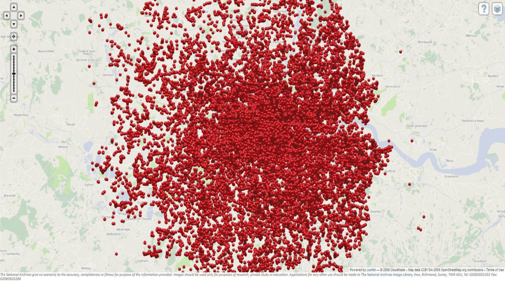
The deep frustration at being able to map the Syrian civil war around Aleppo–combining the actual inability to map the factions in the conflict, and the actual unmappability of the deeply unsettling destabilization of civil society in the five-year civil war which is waged by outside actors, as much as by the Syrian government–has sapped confidence in the ability to negotiate a cease-fire or indeed to find a civil solution to a conflict that has both created an ongoing flow of refugees and destroyed civil society in the region, as well as an equilibrium of power. And the more we are frustrated in being unable to map the conflict and its descent into inhumane violence, the more violent it has become and the farther removed from being able to exist again as a country.
Any theater of war is extremely difficult to endow with coherence in a map–one speaks of the “fog of war” to describe the clouded experience in the confusion of military conflicts. But the difficulty of gaining purchase on the extent of the destruction of the ancient city of Aleppo that is particularly troubling–and troublingly matched by the difficulty of mapping or imagining the targeting of the city and Aleppo’s inhabitants and the refugees who have left the city. The failure to describe, document, or respond to the costs in the sustained aerial bombardment in recent months seems an abdication of ethical responsibility before such escalated destruction that almost fails to acknowledge its scope. The terror of aerial strikes against civilians have led to the targeted destruction of schools and hospitals in the rebel-occupied regions of the city hard to imagine, as a besieged city is isolated from the world. While we don’t have access to the maps and plans that were used during the sustained engagement of rebel forces in Aleppo, and have rather watched screen-shots of the diminishing areas of the region “held” by “rebel forces” over months, those very images distance us from the human rights tragedies that is occurring on the ground with the dismantling of public health care and social institutions, as if extending so many false possibilities of the tenuous grasp over territory of opposition groups. With unclear data on suffering, deaths, refugees or destroyed buildings in the encircled city, we map territory as the clearest index of the balance of war, but ignore the scale or scope of its ongoing bombardment and destruction, as the country has not only “gone dark”–
–but the city destroyed under unimaginable sustained assault.
News wire sources have tried to “map” the extent of those lines areas held in the heavily bombed city, to be sure, in recent months. But the absence of clear lines of jurisdiction or control of a battle that is increasingly waged from a move–but shown as if it were a land war–echoes the military divisions of cities in ways that seem incommensurate with the suffering or mischaracterization of the actors of the war, and the lack of limits with which the Assad regime has enlisted foreign help to destroy its former cultural capital and economic hub, as if trying to efface the opposition that it has for so long successfully tarred by their association to ISIS and the Islamic State–and as a media blitz has tried to portray the battle in Aleppo as a fight against ISIS rather than a defining moment in the escalation of military forces against one’s own people by Bashar al-Assad.
Even though the aerial attacks on Aleppo began as early as July 2012, the escalation of attacks by Russian bombers that began to target buildings and humanitarian supplies with intensity from July 2016. While we were in the midst of the farce of our recent American Presidential election, we have watched maps of the Syrian conflict at an odd remove, depicting the city the city as a multi-colored sectored region, as if a point of stasis in slippy map of sovereignty, as much as a focal point where five different forces seem to lock horns. The disservice of these opaque colors seem to erase and to be done such a deep disservice with Microsoft Paint. And as we do so, we can only fail in an attempt to chart the intensification of suffering that is only like to increase in coming months, as the shrinking green lands held by rebel forces have depicted the so-called “situation in Syria” in increasingly disembodied fashion.
As we watch the layers of colors, trying to map the levels of conflict from an empyrean remove that has echoed the official policy of not putting “boots on the ground,” we fail to account for the destruction of houses, massive departures of residents, targeting of humanitarian assistance and destroyed infrastructure and human services in the city. The layers with which we discriminate a war-torn city set to conceal terrifying human costs in the rather terrifying palette of pastels in its curious camouflage, as if to hold out hope for an amicable solution, but to erase the destruction of civilian lives, hospitals, residences, or food and needs supplies that tried to arrive in the light green rebel-held areas of the city that suggest an island around the Citadel of Aleppo.
For the limited information about Aleppo’s continued destruction by aerial attacks as well as bombardments makes the extent of the human costs its destruction increasingly difficult to render with coherence. This absence of this coherence perhaps leadt some twenty-nine million to be struck by viewing the dazed five-year old Omran Daqneesh and the tragically bloodstained face from which he gazes somewhat stoically and looks at his bloodied hand–as if dazed to be transported from the scenario of violence in which he lived to what seems a setting of sanitized medical care, his blood-stained face contrasting to the clean orange cushions of an emergency ambulance. The transferal of Omran from the battlefield like context of Aleppo to the emergency health care vehicle show him dazed not only at his change of context, but almost in shock of being in a controlled ambulance in which he sits, if a sign of hope, is also emblematic of the inability or difficulty to bridge the controlled context of medical and clinical care of the Emergency Medical Services and the rubble of the besieged city, almost the negative image of a controlled environment: the image circulated by Aleppo Media Centre was emblematic of the dissonance between the emergency services and the onslaught of bombs where civilians are targeted daily amidst the rubble of the besieged city, so that the dazed look of poor Omran seems a substitute for our own helpless bewilderment at the war crime of the sustained aerial bombing of Aleppo’s buildings, health care providers, hospitals, and inhabitants.
If the image is manipulative–and difficult to include in yet another post on Aleppo–its power seems to derive from the failure we feel between inability of the child who touches his hand to his head, to take stock of his head injury as he tries to process the loss of his family, after being carried by an emergency worker into the new setting of an ambulance. The image was so poignant it was shared so widely all over the world on Facebook, as we searched collectively for an emblem of good, of one child rescued from the violence of Aleppo–as nine million Facebook users tried to transcend the broken windows, destroyed buildings, and slim hopes for the survival of Aleppo’s citizens, increasingly targeted in inhumane ways to which we are so unable to respond.
For if there is a lack of any coherent purchase on the city’s destruction on such an unprecedented scale of its bombardment, even for the Syrian Civil War, the saving of one child after his family was lost allowed the survival of a child to exist in the blood-streaked face of the five-year-old Omran Daqneesh that circulated globally on social media seemed finally to locate a “face of the Syrian Civil War” against the city’s dire destruction. Indeed, the actual improvised settings of health care in eastern Aleppo–
–continued as bombs continued to strike the neighborhoods and where the living and dead lay beside one another in emergency rooms that lacked adequate medical supplies. The absence of medical assistance or facilities, even as Bashar al Assad rejects the last proposal proposed by the United Nations for a local truce that recognized any claims to separate sovereignty of rebel forces, if it was not armed, arguing that it was a violation of “national sovereignty,” seems to have invited an endgame of increased military raids, as the “area held by rebel forces” has shrunk in recent days to a small region curving around the medieval fortified Citadel, sandwiched between advancing regime forces.
The garishly bloodied face of Omran, the sole survivor of an air strike on his family home in Aleppo’s rebel -held territories, seemed a ghost, but served as a respite from images of the dead, and his transport to an ambulance from the horror of Aleppo seemed a promise of the future. The image posted by the Aleppo Media Center provided little orientation to the actual struggle, but the apparent shock of the contrast of Omram’s evident transport, his face and T-shirt covered in dirt and blood, to safety offered more than a reprieve from image of dead children: seated in an ambulance, fingering his bloodied head, his place provided a bizarre juxtaposition of a world of safety and medical supplies who had moved from the bombing of his family’s building in a war-torn city we can barely map. The arrival of the child into a setting of Western safety almost seemed an image of the precareity of saving a child out of its destruction, and preserved an odd ability of hope even as airstrikes would soon hit four hospitals in east Aleppo, and continue to target civilians.
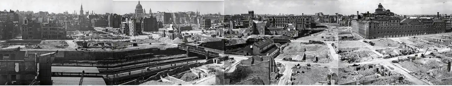
When the Germain army declared, in April of 1942, as accelerating violence of global war brought the arrival of the British bombing of German towns, the wartime Nazi government boasted that they would use native maps in the public domain to destroy valued buildings in England with impunity. over 20,000 bombs fell on the city of London, destroying beyond repair 116,000 buildings, they left a bombed out landscape that has been forgotten with time, but increasingly offers an eery reflection of the twenty-first century’s bombed out landscapes created by saturation bombing raids that the precision strikes of GPS-enabled missiles allows. The bomb sites persisted long after World War II ended, scarring the urban landscape as it was dramatically overbuilt in n unheard of density unforeseen in wartime years, so that it has increasingly faded from our collective memory, even as we try to prevent the bombed out landscapes of recent memory becoming a terrifyingly blur.
In blood-curdling claims that prefigure the American threat to violate international law by targeting of historical sights in Iran, the bombardment of Syrian cities by Iranian supplied forces, the bombing of cities in Ukraine, or the Israeli bombardment of Gaza by precision strikes, the V-2 bombing of London began from the declarative Teutonic bast of a boast,’We shall go out and bomb every building in Britain marked with three stars in the Baedeker Guide.” The conversion of a tourist map to a map of targets may suggest slippage between German fetishization of precision in tourist maps tied to cultural formation to a German Luftwaffe’s determination for an arial blitzkrieg determined to destroy historical sites. The precise strikes of flattening a landscape by V-1 bombs and V-2 rockets blanketed England with a “Vergeltungswaffe” of vengeance weapons, an air-launched arsenal designed to destroy whatever had once been celebrated on the map, with a destruction that was poorly processed in literary terms as it was hardly able to be understood.
A screaming comes across the sky . . . it has happened before, but there is nothing to compare it to now.” There was no precedent for the destruction of the London Blitz, and the experience of a bombed out landscape was hard to distance oneself from–and all but impossible to map. If Thomas Pynchon invited us to imagine the progressive targeting of the city–writing in a time when many bombed out areas of London were still fenced off, some still not benefitting from the Lend Lease act of government financing, and some still present in the 1970s, when I visited the city as a child, the bombed out landscape is impossible to imagine in real time, perhaps, as the front lines of war blurred with the home front. During the blitz, Graham Greene gave it his Eton best, chiding Anthony Powell how the bombing raids made London “extraordinarily pleasant these days with all the new spaces” as rocket bombs had torn through buildings: Greene distanced himself from violence by affecting admiration for the “rather Mexican effect of ruined churches.” He was not only being picturesque, but looking back on the hatred he felt for the Mexican landscape whose ruins he had officially visited in 1937-8, while investigating Socialist outlawing of Catholicism in Mexico; the dark sarcasm no doubt concealed fears rockets rendered the capitol akin to the landscape he saw as a periphery whose poverty and dishonesty he loathed as “a state of mind” without morals, economic precarity, bad food and drink, and bad faith.
The bombing of London followed the escalation of raids launched on Germany from seven airfields built for the purpose in East Anglia, after 1940, which had dropped seven hundred and thirty-two thousand tons of bombs on German cities by the new strategy of “carpet bombing,” creating firestorms in German cities from Cologne to Bremen, from Würzburg to Stuttgart, and many more, creating landscapes of instant ruins in a form of psychological warfare that seems to effective to be almost omitted from German postwar literature. Whatever churches Greene saw in Tabasco and Chiapas were empty of ritual or priests by state decree, secret Masses confined to private houses by priests who register with civil authorities after agrarian and land reforms stripped the church of property. If Mexico seemed a periphery, London seemed in danger of becoming one, as Britain’s bombardment by Germans hoped to reduce England’s capitol to ruins; he disdained American superiority to Mexico whose wealth they had extracted, and thought little of the “cold, snarky chambers” of Mexican ruins in the seventh century Mayan city of Palenque, but the bombing of London by “vengeance weapons” threatened rapidly to reduce the metropole by a Third Reich that hoped to triumph over Britain by consigning it to the past to bring to a close an early historical epoch.
If Mexico was “a country to die in and leave ruins behind,” the specter of silent, majestic ruins may have been hard to map onto London, but the Bomb Damage map undertaken by surveying the buildings damaged and destroyed by German bombs provide a fascinating attempt to maintain equilibrium in a time of devastation. The evocation of a ruins was telling at a time in the almost exactly eight month bombing campaign from October 1940 to early June 1941. V-2 “vengeance weapons”–or simply “revenge weapons”–were unlike earlier types of war, definitively shifting military hostilities to a home front. If Graham Greene had imagined Mexico as the glamour site of the adventures of Pancho Villa in his childhood, the dangerous landscape of wartime suggested , the start of a campaign whose targets were chosen from a travel guide was a metaphor of how bomb strikes might close a historical epoch by sheer application of force, confirming the imperial destiny claimed for the Third Reich, and reduce London to the material traces of a past Germans long studied of Rome’s Empire and ancient Greece.
It must have been quite hard to watch the raids at the stoic remove it demanded, but the British were up to it. The emigre bookseller and intellectual historian Chimen Abramsky tied to wacth at close hand London’s bombing unfold by binoculars from the roof of his Highgate residence, scanning the urban landscape for the sight or sound of bombs’ inevitable before joining fire brigades to rush to the scene to mitigate flare-ups in urban neighborhoods, stunned “London was on fire, burning from four sides,” as if the Nazi invasion of Poland, Belarus and Russia had followed him and his father refuge. The V-2 bombs were perhaps only a rehearsal for the aggressive carpet bombing of the Siege of Stalingrad of late August 1942 they preceded; the utter destruction of those air raids challenged novelist Vasily Grossman’s points of reference–“Everything burned down. Hot walls of buildings, like the bodies of people who have died in the terrible heat and not yet cooled down . . . miraculously standing–amid thousands of vast stone buildings now burnt down or half-destroyed,” he wrote in his notebooks. Stalingrad became a landscape of historical ruins, “like Pompeii, caught by destruction in the fullness of life.”
Is it an an oddly English response to try to map this destruction in poignant pastels, as in the header to this post? The elegant maps of the destruction of buildings that were tallied with care during the Blitz cartographically process the bombs’ arrival in an array of watercolors, as if to hold at distance the violence done to place with which each writer–Greene; Abramsky; Grossman–struggle to frame in a language of ruins that suggest historical breaks. They affirm the continuity of the landscape, rather valiantly, against Ordnance Maps, as if to chart hopes for rebuilding.
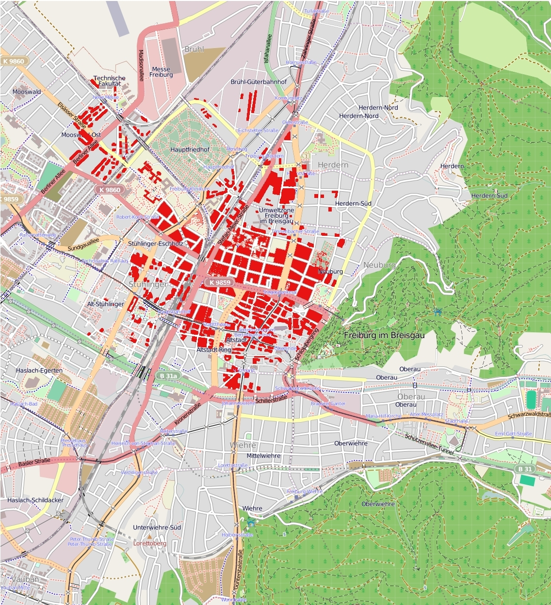
They are far leess abstracted than recent dense collection of red datapoints of where bombs hit in the recent webmap “Bombsight” charts, which illustrate the overpowering reach of the rockets but makes it hard to comprehend the scale of their effects by the density of these crowded datapoints on a Google Maps base map–even if one zooms in on closeups on individual neighborhoods against the muted generic landscape of a base map. The unprecedented intensity on London, temporally collapsed, challenges the viewer to process the impact of eight months of rockets in totality. The preservation of a set of hand-painted Bomb Damage Maps created to assess the rockets’ devastation in real time offer keys to navigate that experience, as records of the cartographic reaction to the modern violence they wrecked and the transformed urban landscapes that so many Londoners continued to inhabit.
Mapping the World War II Bomb Census: Rockets Targeting London, October 7, 1940-June 6, 1941 Bombsight
As the destruction of these cities fades from collective memory, the online sources of like “Bombsight” that aggregate actual geodata placing the density with which all rockets and bombs dropped on the city in individual time frames offer something like a slider bar to view the violence, without the fire and death, remotely on our screens. But how to describe or take stock of the scale of such devastation, let alone to do so in a map, or to make contemporary maps and accounts to be embodied in an adequate spatial form? For the journalist Grossman, bombs that fell amidst the flames of burning houses over Stalingrad redefined the place as it had been known from maps, and redefined the lived space of the city that were unable to take stock of by a single observer. “It was no longer a matter of individual explosions; all space was now filled by a single dense, protracted sound” of the howls of bombs, air cloudy with white dust and smoke, the characters of his novel search for images of Pompeii, wondering if any one will remember them, the thunder of explosions and crack of anti-aircraft guns marking time against the howl of a bomb that grew in volume, altering one’s sense of time as “howling seconds, each composed of hundreds of infinitely long or entirely distinct fractions of seconds,” erased desire, memories, or “anything except the echoes of this blind iron howl.”
Whether referencing the obliteration of space by the Baedecker guides was a conceit of historical migration of empires or conflated cartographical superiority of touristic guides with the precision of aerial bombardment suggests the crossing of categories of bombarding civilian populations. The obliteration of clearly demarcated lines haunted Stalingrad’s bombardment included modern incendiary bombs, for Grossman, as tens of thousands of which small canisters that could tumble out of in containers of thirty-six filled the air with a distinct screeching unlike the whistles of high explosives, a screeching that echoed the screeching of the V-2 bombs that Thomas Pynchon employed as the arresting auditory perception of the mesmerizing opening sentence of Gravity’s Rainbow focusses on the “new sound” then unknown of “A screeching came across the sky” . . . Grossman focussed on the “new sound” bombs made in Stalingrad as unlike the whistle of hunters of high-explosive bombs, but “penetrated every living being [from the] hearts of those about to die [to the] hearts of those who survived–all hearts clenched in tight anguish,” so that “there was no one who did not hear it as they plunged into the city, rendering “building after building joined in a single blaze and whole burning streets fused into a single, living, moving wall . . . as if a new city of fire had appeared over Stalingrad,” introduced by the distinct sounds that follow the arrival of “planes coming from north, west, east and south [that] met over Stalingrad,” whose descent on the scientific “seemed to be the sky itself that was descending–sagging, as if under dark, heavy storm clouds, under the vast weight of metal and explosives.”
To register the new city rendered by daily destruction, lest the earlier city by lost, the London City Council undertook in a valiant act of cartographic preservation during the air attacks from September, 1940, just after the Germans had planned to invade Russia, to 1941, and amplified with the attacks of V-2 rockets by 1944, to ensure a level of destruction more sudden and more terrifying than the incendiary bombing of Stalingrad. The ways that the British Army mapped the destruction that V-2 rockets of terrifying precision were able to carve out of the city of London had been long lost, but the recovery of these map provides an eery echo of the historical models and precedents of civilian targeting of historical sites that haunts the contemporary world. For he scars of ethanol-fueled V-2 rockets that speedily struck wartime London seventy years ago are a good place as any to start to map the systematic bombing of civilian spaces. As if mapping the liquid-fueled fantasies of destruction of Wernher von Braun, the V-1 and then, subsequently, V-2 bombs silently arrived to create a psychologically searing topography of death that transformed the city, immersing civilians to new topographies of fear.
The contemporary graphic tabulations of damages in recently published Bomb Damage Maps orient one in chilling ways to the progress and degree of bombing wartime London in purples, violets, oranges, and light blue on London’s familiar plan. The pastels are disarmingly tranquil if not placid in tenor, but seem to conceal within a Benjamin Moore-like in their variety, which seem to reveal a of destruction wonderfully measured concealment resistance of a British culture of grim-faced exactitude to the horrific episode of wartime destruction, generations away from the bombardment of images of bombed out landscapes in Beirut, Syria, or so much of the Middle East and Libya today. If these pencilled sketches seem oddly antiquated and removed, the poignant attempt to come to terms with the radically escalation of destruction in the devastatingly regular tempo of accelerating bombardment that is known as the London Blitz–even if they cannot capture the panic, commotion, terrified screams or chaos, in the muted pastels in an aerial perspective that affirm the organic city that once existed in a still alive past. The three weeks of airstrikes on Gaza that have focussed on obliterating a density of buildings and underground tunnels in Gaza City to drive an underground terrorist cells form the region are only the latest of focussed campaigns; can their experience be better understood by guides to process aerial bombing raids in the past?
The images of community that they preserve in a time of the compacting of time and space stand in a bizarre psychological counterpoint to the terror of the Blitz, an attempt to maintain level-headedness perhaps in the methodical taking of stock of the sites that were apparently be turned into Baedekers of a future lost world. The bombs that clustered on London in the Blitz are not only preserved, but collated, in a stunning overpowering overlay that suggests a puncturing of space if not obliteration–in a collation of the sites of all German bombs dropped on London in the Blitz, September 1940-June 1941, courtesy “Bombsight“, embracing a massive repository of spatial information aggregating locations of all bombs dropped on the city.
The data is so overwhelming, of course, that the viewer is vertiginously unable to process the extent of detail it aggregates, in what might be better known as a Cartofail. The multiple maps that were made by the Bomb Damage Maps tend in the reverse: they preserve the underlying street network and sites of all buildings in the city, preserving a palimpsest that survives in the face of aerial bombardment that attempted to efface any sign of human habitation; the result is a valiant basis for the recreation of the future of London in a dark period, and a particularly healthy and plucky form of cartographic resistance, of sorts, running against the collapsing of time and space in a time of total war, by trying to retain and train attention on what exists in the city that can be preserved lest it be forgotten. In the face of total war, it is a resistance of exactitude.
The maps recall those colored glossy stars pasted, in the manner of pins, at the sites of explosions in London, which “cover the available spectrum” from silver to green, gold, red, blue, and a surprising preponderance in certain areas of violets whose locations seem to coincide with bomb strikes, but are so suspiciously marked with the names of women, the silver ones labelled “Darlene,” others Alice, Delores, Shirley, Sally, amidst Carolines, Marias, Annes, Susans and Elizabeths. The disjunction between names and places map the interior experience of Lt. Slothrop against the city that became a canvass of war, but the placid colorings of the map hues suggest a deeper disjunction between mapmaking and violence.
The maps capture an attempt to take measure of the scale of destruction, from black areas bombed out beyond repair to more lightly damaged areas in yellow, as if to process the unprecedented scale of disaster in the precision of the Ordnance Survey Maps. In ways that seemed to try to contain the violence of the bombs that killed over 9,000 by a coloring the sites that were hit by the daily assessment of bomb damages, Bomb Damage Charts drafted by the London City Council tried to process the daily destruction that took the toll of 9,000 in what Germans portrayed as revenge for allied bombers suggest an English tabulation of the ethanol-fueled violence, called as retribution for allied bombing of German cities, that revealed fingerprints of the fantasy of Wernher von Braun, the rocket scientist who was driven by truly stratospheric aspirations to reach the moon.
And they reflect, as such an attempt to map the devastation Thomas Pynchon so famously began Gravity’s Rainbow by suggesting the sudden arrival of an ethanol-fueled V-2 rocket that struck the zero Greenwich meridian around 1967, by describing a volley of ballistic missiles whose targeted strikes and explosions brought to life something like a new world, and a terrible one that is punctuated in a senseless sequence of devastating strikes. And as Pynchon famously used the Matthausen testimonies to describe the horrors of the bombs’ production during the war by the remain side, the bomb damage maps would have provided powerful means to elaborate the destruction of the city came to map the fictionalized if troubled ever-idiosyncratic psyche of Tyrone Slothrop. The rooftop observations of the arrival of V-2’s that arrive, arching short of the land and arriving on London, tracked by a group of Yanks, stationed at the Allied Clearing House, Technical Unites, Northern Germany (ACHTUNG), a paper warren filled with black typewriters that pose as grave markers, removed from the war but close to its violence.
As much as orient one to the destruction of bricks and mortar buildings, they suggest a way to complete the terrifying topographies of the wartime city, as familiar cityscapes suddenly vanished, taking human lives in a chaos difficult to psychologically sustain. If Stephen Spender described how in “destroyed German towns one often feels haunted by the ghost of a tremendous noise” as it “is impossible not to imagine the rocking explosions, the hammering of the sky upon the earth, which must have caused all this,‟ evoking the inability to grasp or orient oneself to the ineffability of the sensory barrage of modern destruction with particular eloquence. Pynchon was particularly attentive to transpose the complicated topographies of what were otherwise blank space by recourse to the “old Baedeker trick” not limited to that genre of travel books alone, but pillaging from WPA guides and other maps, in ways that make it more than likely that something like the Bomb Damage Maps provided a similar basis to orient his readers to imagining the new topography of war in which his characters sought to navigate as best they could, and the tourist maps of post-war London which rendered the continued effects of bombed out areas light green offered an effective palimpsest as any to recover the psychological trauma of the destruction of the psychic network of place and society–
–itself a mirror image to the German Schadenskarten created to document the parallel six years of trauma inflicted on cities in the Nazi state.
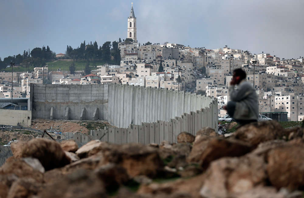
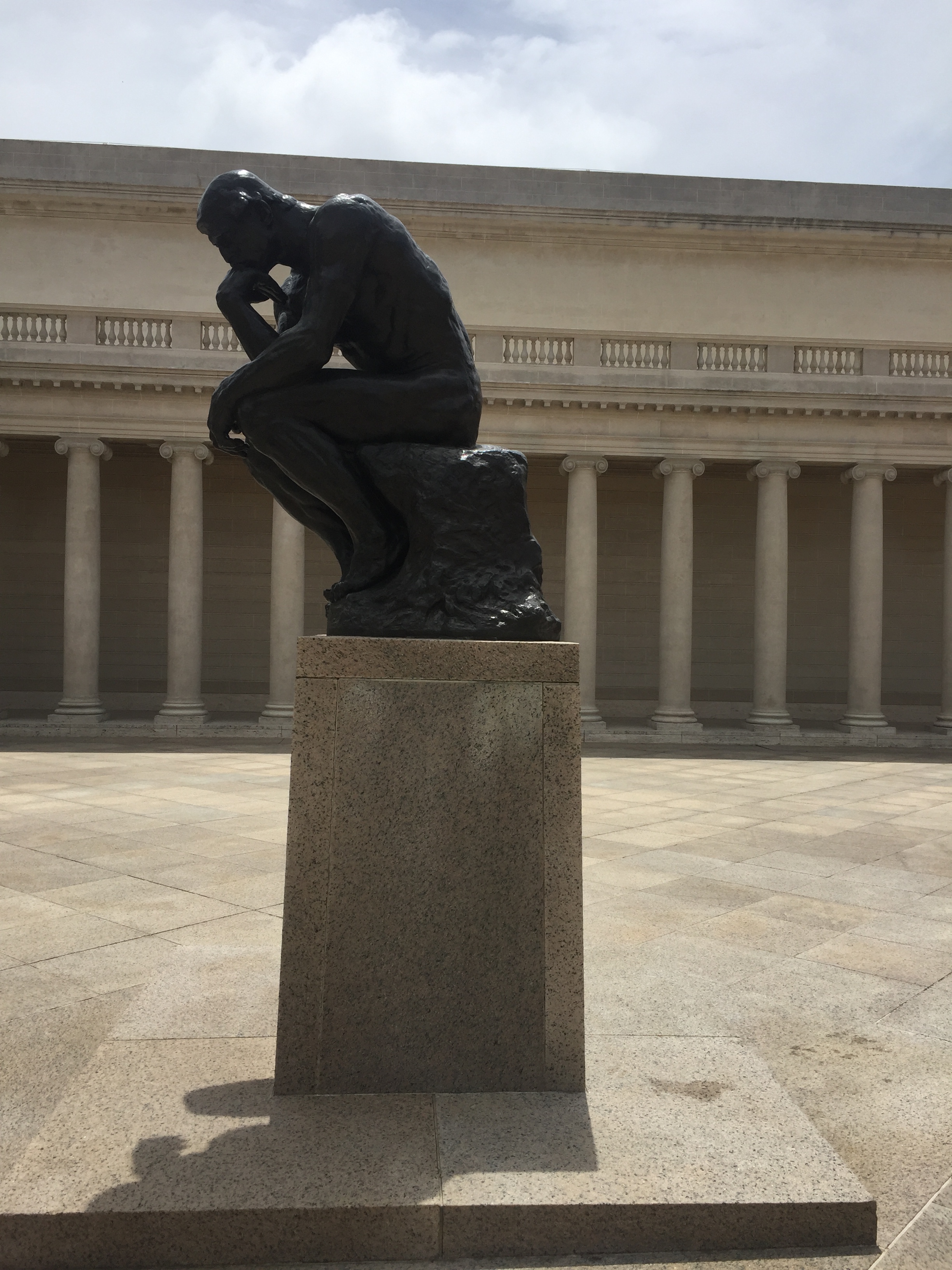
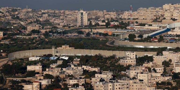
The Palestinian mutely contemplates the sheer concrete expanse of the Separation Boundary as an exile from his homelands, as if pressed by the newly constructed boundary barrier that he rather stoically observes. What passes through his head, we can’t say, but this blurred figure, captured as he rather eerily recalls Rodin’s Thinker, seems to contemplate the new future of a redrawn boundary to which he has an existential relation. The erection of poured concrete walls have created an apparently permanent border boundary across what he regarded as a homeland, and would contest. But the existential present of this moment conceals the depth with which such boundary lines were long historically contested and redrawn on maps, in a contest of wills that transcends the individual or present tense. For the man outside the Separation Boundary contemplates a complicated map of shifting territories, difficult to bound, whose boundaries have been painfully renegotiated in the past as they are again rewritten in the present. And as we debate “border security” in the United States, contemplating an artifact that was imported in large part from Israel, we would be well to consider its prehistory, and the criminalization of the crossing of borders in the past. Does A.B. Yehoshua’s imagined archeology help us to do so?
Difficultis of discerning this face of the figure contemplating this Separation Boundary doesn’t conceal that his removal from the city of which he is resident, and the traumatic division among two halves of the city that he once knew as his home. If the dream of Zionism parallels the time of the commission and production of monumental bronze castings of The Thinker, commissioned in 1880 from the sculptor who began to produce multiple versions from 1904, around the foundation of the political movement of Zionism launched in 1904, to establish the protection and international recognition of an Israeli stage, the fiction of deep affective commitment to the place and boundaries of Israel in the historically defined Holy Land is the subject of seductive palimpsestic unpeeling of the past of one family in A.B. Yehoshua’s Mr. Mani, a historical novel retrospectively stretched across five generations who seek their orientation to a Holy Land and to Jerusalem in ways that they cannot fully ever grasp–but which the reader begins to as he reads the novel’s five parts, as the boundaries of the state of Israel are peeled apart over time in what seems a modern pentateuch of the state, and a new genealogy of the Holy Land.
The boundary line that has been drawn over an area once easily and regularly crossed by foot suggests the deep stakes at claiming a tortured relation to the homeland by the Israeli state, and the threat that the rebuilding of this boundary creates not only in his psyche, but that haunts the psyche of the Israeli state. The deep memories of a tie to place that the boundary barrier seems to defend cut off residents from their home, even as they intend to create claims. The contrast between the existential remove of watching the concrete separation barrier recently constructed in the city and the historical attachment to the land of Jerusalem prompts questions of archeology of boundaries, barriers, and attachments to place. The tension between the most recent barrier and the deep historical ties to place seem to condense the repeated historical redrawing of boundaries in the city and the nation, and psychological problems of drawing or respecting boundaries between peoples and individuals, and the fragile nature of place across shifting boundaries. If rooted in questions of migrations from Europe, across the Mediterranean, and in Israel, which gains concreteness only in the difficulty to map the psychic relation of the person within this place.
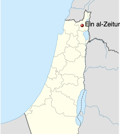
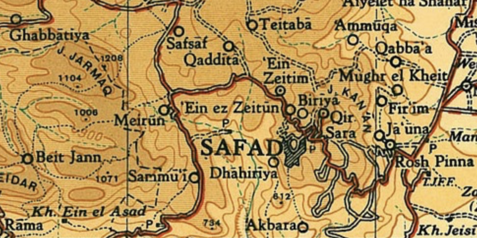
Elias Khoury begins Gates of the Sun by describing the specific romance of the map in similarly inter-generational terms, and in truly global terms as ruminating over over the spinning of a globe in a camp outside Beirut, Abu Salem remembers a past toponymy in mesmerizing manner, shifting from Biblical to Palestinian register that shifts to from rhapsody to melancholy and from a real to an imagined map–“”That’s Acre. Here’s Tyre. The plain runs to heart, and these are the villages of the Acre district. her’s Ain al-Zaitoun, and Deir al-Adsad, and al-Birwa, and there’s al-Ghabsiyyeh, and al-Kabri, and her’s Tarshiha, and there’s Bab al-Shams. . . . . Ain al-Zaitoun is the most beautiful village, but they destroyed in in ’48,'” describing an Arabic Palestinian village that existed from the sixteenth century which was depopulated and left the map, as it entered the new boundaries of the modern Israeli state–within whose boundaries it disappeared, receding from maps into personal memory.
The historical challenges of occupying Jerusalem, and indeed preserving a deeply personal and spiritual tie to land, seems tied to border crossings–and indeed creating boundaries–across the city’s ancient geography that the man stoically overlooks.
We are perhaps all too ready to project his traumatic relation to the the contested boundary lines of contemporary Jerusalem, where concrete walls cuts Palestinians from the very regions of a city they long inhabited as it seeks to redraw its map, as if to further traumatize its residents. While the figure of the Palestinian echoes the notion of a Rodin’s Thinker, contemplating his place in the world, he has a far more clearly located place than the famously mobile piece of sculpture, whose reproduction in casts and in marble transited around the world, moved on a pediment to any space, evoking an idealized act of thought in whatever context it stood, begging the question of its own subjectivity in relation to space:
Legion of Honor, San Francisco, CA
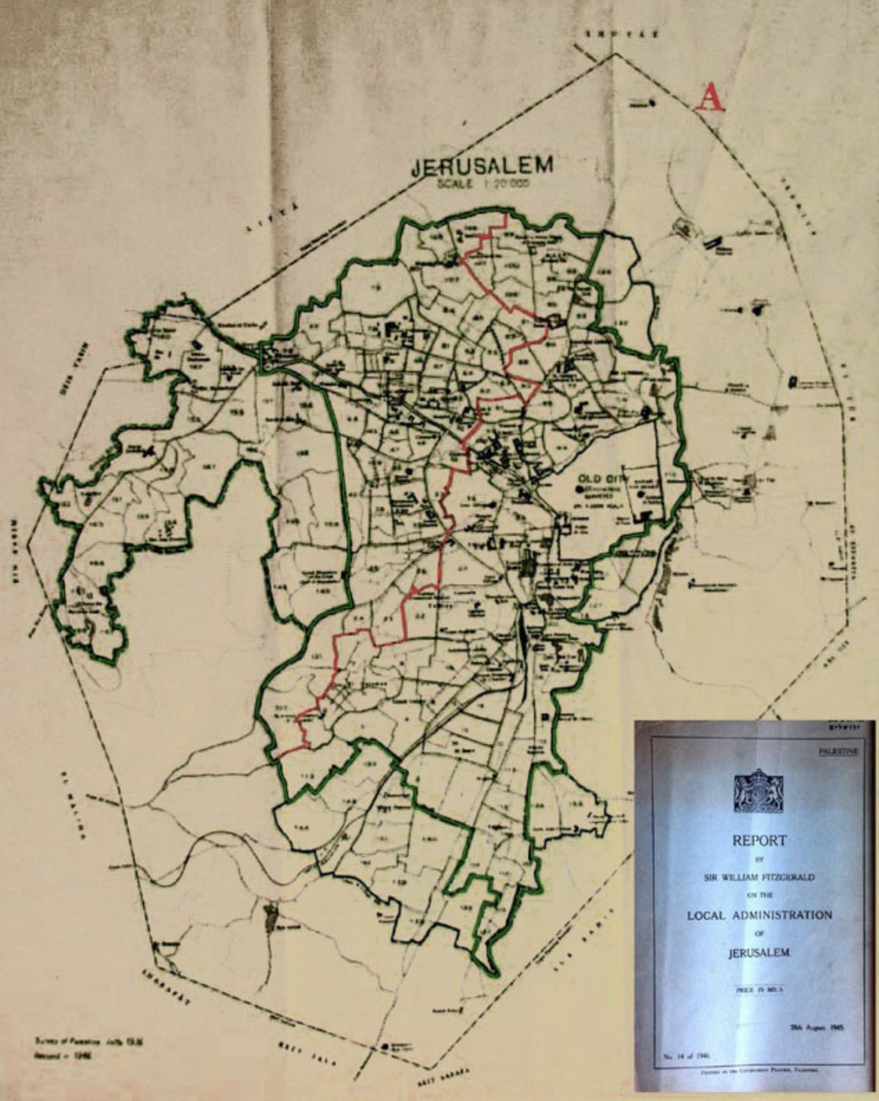
As a student who had studied in Paris–and, one imagines, understood the possibility of Hebrew as a literary language that would embrace multiple identities and subjectivities, as French did in the monde francophone–the image of a Rodin statue is, while a bit jarring to place as an explanatory motif to enter the Holy City and boundary-drawing of the Israeli state, an apt choice to place Yehoshua’s very public if not political literature in relation to the boundaries that he witnessed drawn up around the Israeli state, and treated his own work as a testimony to. It is striking that, of course, unlike the subjectivity of an Arab or Israeli, multiple casts of Rodin’s statue were famously mobile, able to circulate globally, independent of site, as icons of man’s intellectual superiority over the world and his surroundings. But the man sit with a site-specific sense o reflection, and effectively caught in the act of being displaced from his surroundings: a city which has long been praised because of its integrity in the religious imagination, and translated to a nation a term that was long reserved for applying to a people, has been beset by divisions that the boundary wall has mapped in Jerusalem is both palpable and insurmountable reminder. The statue reveals a pragmatics of division that is oddly and paradoxically described as intended to preserve the integrity of the city, by defining its place and security in the public imagination as if to recuperate and preserve a sense of the imagined topography of unity of the Mandate in 1946–before the foundation of kibbutzim, before the Irgun’s armed resistance to British military authorities, and before the foundation of the state Israel, if with clear boundaries of sovereignty.
Did the story of the settlement of Jerusalem as a succession of subjectivity offer a truly transcendent relation to place, before which maps receded as purely provisional conventions to orient one to space or place? The novel provides a place, perhaps, if a bit by happenstance, as expressive of the cosmopolitan remove and liberal principles by which A.B. Yehoshua seeks to map the place of the subjective figure in the fractured Holy Land, and indeed the recuperation of Enlightenment principles by which to do so for a literature that he sought to provide the country, very much as a pragmatic resource akin to plumbing, running water, or electricity and gas, as much as a refined culture. The embodied culture of space may have led Yehoshua, whose father arrived from Salonika to the Palestinian Mandate, and whose mother arrived with her father from Morocco, when few Jews lived in the area that became bounded by the future state of Israel, to angrily reject the existence of the diaspora as a future for Jews and even as a meaningful or authentic mode of being for modern Jews, and especially among his readers: if Mr Mani seeks to orient its readers to the complex drawing and redrawing of boundaries in the Middle East around Israel, in order to transcend them, and takes the figure of a succession of subjectivities to provide a unity by which to place oneself in the continuity of the Israeli state, despite its modern creation, Yehoshua railed angrily in increasingly bitter terms about the diaspora or galut as “masturbation” rather than true being, in later years, as if in relation to his own sense of impotence at the sheer size of the diaspora–a reflection of the prospect of his own sexual impotence?–compared to confronting a multi-ethnic sense of territoriality in Jerusalem, and in the Holy Land, he had first encountered as a child.
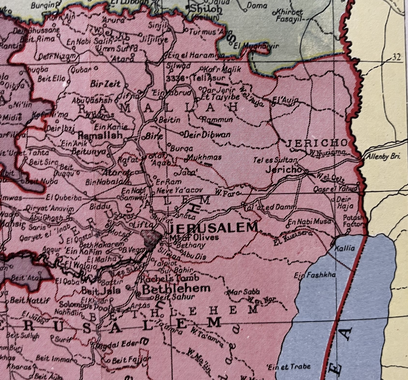
The sectorizing of the city by such boundaries were akin to a rejection of history, or of the Zionist vision of crossing borders–a vision, to be sure, later corrupted in the shift of Zionism to Israel’s borders’ fierce defense. The sense of imposing borders on history, however, and on place, led Yehoshua to create one of the fiercest stories of the repeated crossing of borders over time, of location despite borders, a book written in a sort of locative voice, transcending early proposals dividing the city among Arabs and Jews drafted the very year of Yehoshua’s birth in the Palestinian Mandate, and a vision of segregation that the work and vision of his father to create a commonly understood legal code would span. The turn to writing and to stories to suggest the intertwined nature of Jews beside Arabs, not segregated apart, provided a means to narrate the demographic mixture of Jerusalem at the time–the city was populated by about 92,000 Jews; 32,000 Arabs; 27,000 that precipitated the division of the city into East and West regions as the prospect of a Jewish Mayor of Jerusalem was flatly rejected
Proposed Partition of Jerusalem’s Local Administration into Jewish and Palestinian Sectors, “A Proposal for Dividing Jerusalem between Jews and Arabs (Survey of Palestine,” Jaffa Aug., 1936)
The crossing of boundaries and persistent problem of crossing boundaries to preserve a coherent vision of Zionism becomes the question or logic for the generations of Mani in a question of what Rivka Galchen called “serial subjectivity” that cannot be understood but in relation to the impetus of crossing boundaries of the map, itself drawn in the year of Yehoshua’s birth. The fictive figure of a “Mani” at the center of this fictitious archeology of a heterodox in Jerusalem parallels the reconstruction of the historical figure of “Mani,” a prophet who was a member of a large Jewish Christian sect in Babylon with strong Gnostic elements as the future prophet described in the New Testament. Mani’s faith was rooted in the creation of a new gospel, in visions perhaps influenced by the fact that his mother was of Parthian descent, of Armenian origins, and was raised in a community of Jewish Christians, but who preached a heterodox faith that combined Christianity, Hinduism, Buddhism, and Zoroastrianism in a new heterodox complexion: he wrote six works in Syriac, and was eventually crucified after he preached his idiosyncratic heterodox faith to the Indian court of Shapur I in 242, crossing barriers in his life that the six generations of Mani whose fictional archeological record Yehoshua invites the reader to sort out across recent incursions and wars, each replaying the Manichaean conflicts that the historical Mani preached: the genealogy traces conflict across borders in a succession of ages, as if participants replayed the historical Mani gospel of a Manichaean struggle across Middle Eastern borders, asking if the very heterodox combination of cultures can survive. But the combination of boundary crossings that constitutes the basic story or “news” of the novel–fictive news, but news of present relevance–suggests a deep temporality of all boundaries, and indeed offers a means to work toward their transcendence.
The strong sense of an occupation of the city by generations–“All the generations before me/donated me, bit by bit, so that I’d be/erected all at once/here in Jerusalem, like a house of prayer/or charitable institution,” poet Yehuda Amichai evokes the deep tie to a past that physically ties him to Jerusalem’s present and pasts. The proprietary sense tied to generations of Jews as bound to the city of Jerusalem by a binding tie to place defies mapping. But the excavation of this actually quite modern sense is excavated in Amichai’s poetry and an inevitable subject of Israeli fiction. The next poem in Amichai’s 1973 collection, Poems of Jerusalem, turns from the ties to place to the disruptive nature of the border barrier already built in the Old City, on each side of which flags are raised–“To make us think that they’re happy./To make them think that we’re happy.”–but that obscure who is flying a kite over the Old City, on a string held by a child who stands on its other side; if he cannot ever forget his tie to the city, its walls of separation are never able to be forgiven, but “If I forget thee,/let my blood be forgotten,” to describe the tortured relation that he felt in 1973 to the mapping the relation of the city so closely intertwined to his blood-line.
The issue of bonding to place within one’s blood line was more clearly mapped across time when A.B. Yehoshua compiled a fictional dossier on the testimonies across six generations of men residents in Jerusalem in Mr. Mani, a five-part 1992 historical novel that rewrites a Pentateuch of the Israeli state, or at least the Zionist dream of basing a Jewish state in Jerusalem, a city whose layered history Yehoshua knew well from his father, a local historian of the city, and that in a sense captures his own deep ambivalence to Jerusalem as a homeland or occupied city. By tracing testimonies of the male members of the Mani family who settled in the city and manufactured this imagined tie to place, he allows them to give evidence of their ties to the city across generations we read in chronological reverse, in ways that seem to unpeeled their own deep internalization of their ties to the city of Jerusalem–and the cross-generational desire to create or recreate a physical tie to place. Even if it is only textual, and returns to landmarks in the city, more than to boundaries that we can understand as fixers, the novel traces mental boundaries, offering poignant testimony of the redrawing of Jerusalem on the map. As much as it is a story of the serial succession of subjectivities in Jerusalem, and the Holy Land, the “job” Yehoshua fills for himself of navigating and crossing boundaries–boundaries that were created in his own life, as a man born in the Palestinian Mandate, where his father worked to translate Hebrew to Arabic documents–take the task of forging a new Israeli literature in Hebrew that itself knew no boundaries, but was based in orienting readers to the palimpsestic realities coexisting in the Holy Land. Although this reaction to Yehoshua’s work in the form of a deep dive into the realities of cartographic boundaries was written in the diaspora before Yehoshua’s passing, it is a testament to the persistence of a gravitational pull of place in his work, rendering it as a sort of counter-mapping to the creation of boundaries proclaiming an end of history.
While the novel is removed from historical mapping and remapping of the settlement of the city, it traces a deeply psychic map, preserved in Faulknerian fashion of what might as well be a fictional country but could not be disguised as such. The intensity of personal projects of mapping a relation to place and remapping the desired union of each generation to the city, as if to realize the frustrated desires of their forefathers to map and thereby to create a new relation to place, without attending to its residents, so deep was their desire to protect, redraw, and identify with the place of the ancient city. The creation of one side of the conversations of the Mani men provides a basis to excavate the deeply unfulfilled emotions needs that they bequeathed their descendants, and the incomplete relation that each transmitted as a failure to bind their own family to the city, and the difficulties that they have mapping their relations onto the presence of the city’s actual inhabitants. The deep neediness of Mani men reveals the strength of ties of rooting oneself and family in place, and the heightened trauma of such a desire for attachment that has built up over generations, a traumatic tie to place that is visited upon its other residents.
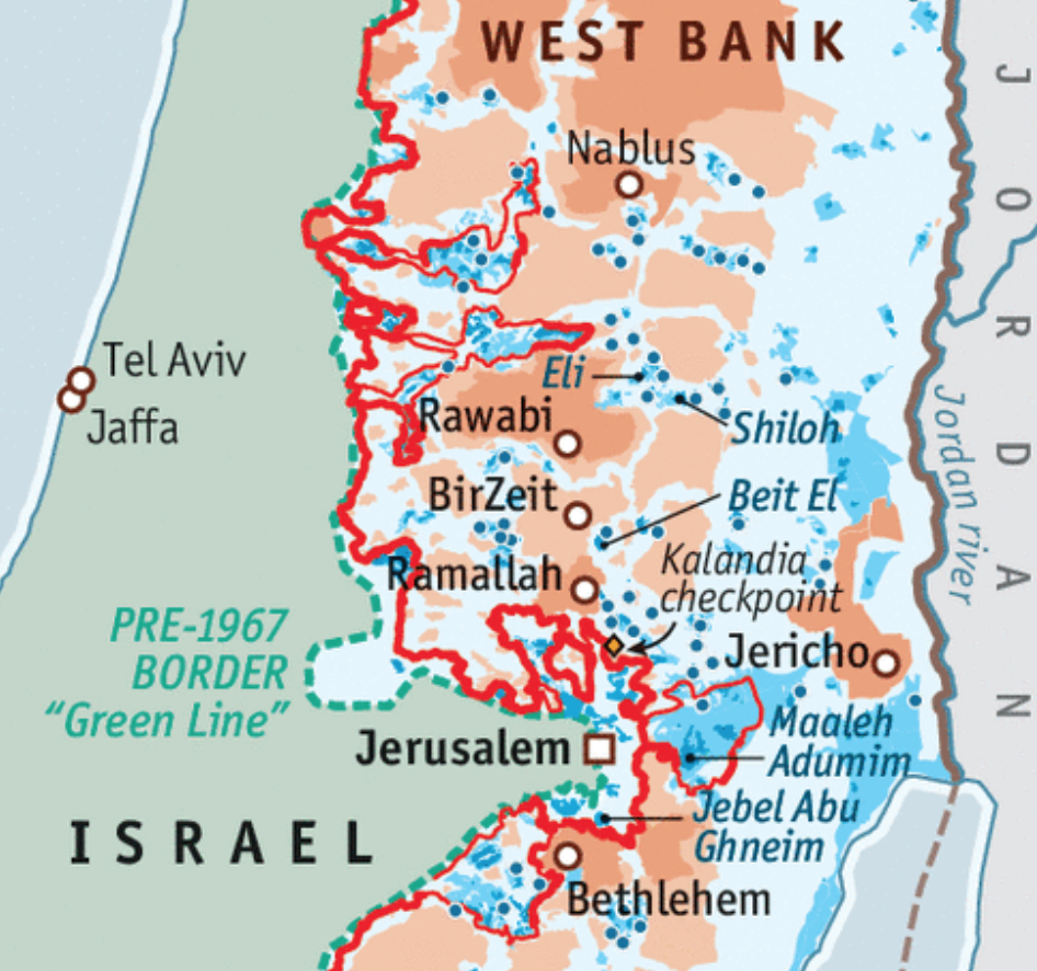
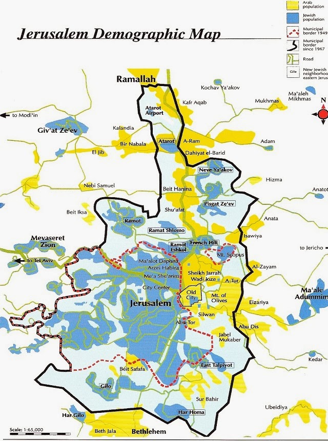
The trauma of the Palestinian who regards the concrete barrier is not, literally, on most maps constructed of Jerusalem or of the Holy Land. Indeed, the trauma of excluding Palestinian presence in the city that the Jewish state has adopted plans to occupy fully, and the provocation of publicly acknowledging it as a capital, seems to seek to enshrine the trauma in maps. For the boundary barrier expanded the line of Israeli control over the contested city–and even exceeded the territorial claims the so-called Green Line of the 1949 Armistice, or the pre-1967 bounds–but were never intended to provide a territorial boundary for the state. If those bounds were treated as the new boundary of a national territory after 1967, the expansion was tired to be remapped by the progressive construction of the barrier or boundary wall much further in recent years, as if to over-write and banish earlier memories of settlement, and to stake a rewritten Israeli sovereign relation to the city, now provocatively defined as a national capital on maps.
Thomas Coex/AFP
At what cost? The project of a unified Jerusalem will hardly conceal the deeply pained relation to the territory, however, and seems destined to only augment its military defense. At this point, it may be opportune to return to the historical excavation of the pained nature of these boundaries–and the compromises that they create in the occupation of lands–is addressed in deeply psychological terms in Yehoshua’s Mar Mani, or Mr. Mani, which traces or excavates the ever-growing costs of such a divide. The curiously retrospective structure of the five books of the novel peel back historical layers of mapping a personalized Jerusalem through the testimony or discussion with men in a family of Mediterranean Jews and their ties to Jews of central Europe, that throw into relief the intensity of a psychological concentration that takes the Holocaust as its justification for the fulfillment of a Zionist project for retaking the Holy Land.
The project of settling Palestine is seen through the eyes of the long stateless Jews and the ties they have staked to the land from the late eighteenth century. While often cited as a justification for the existence of Israel as a state, Yehoshua includes the genocide of the Second World War in his novel about five generations of a family who settled in Jerusalem, but throws the history of their tortured relation to place in a far broader context of the ways that people have long pressed against boundaries, and indeed, confused their own personal boundaries with relations to barriers and boundaries that existed, were drawn, or were being redrawn on maps, even as they tried to use maps to navigate their relation to the city for their descendants. Is the tortured relation to the city something that was bequeathed as a failure to define personal boundaries, and to understand the boundaries that might have existed between Jewish settlers of jerusalem and its inhabitants, that continued to inform either the construction of the wall that extends beyond the pre-1967 border line–
–and the hard place of the wall that divides the complex expansion of the old municipal border of 1949 to encompass its Palestinian and Jewish populations, and the tortured relation each feels to its place.
The border boundary that divides Jerusalem today as emblematic of an utter divide between populations, illegal and asserting itself to be a concrete evidence of the application of the law: the boundary wall seems to deny any past habitation and any past, to create a new realty of borders, even as it seeks to affirm and inscribe a new divide in the city, even if under the pretext of protection from terrorist attacks. But the broad historical conflicts of claiming Jerusalem as a Jewish city–even in the face of a Palestinian majority presence–and ruling it as a sovereign part of a Jewish state, rather than one the acknowledges its multiple ethnicities, conceals the tortured relation to place that is the result of denying any voice to its original inhabitants.
Building the boundary reminds us of the existential quality to any line of partition, and the deep effects with which it immediately effects the place and its inhabitants. The wall, one might say, stares back at the man, sheer concrete without any sense of history or human habitateion, to protect the area extending past the Green Line as if to fix its future movement in the historically shifting map in stable terms. This unstable map–which seems poised to be shifted once again, for national gain, in the 2017 annexation of the new construct of “Greater Jerusalem” including settlements along the West Bank, transforming a place previously without integrity to fulfill a prophecy of the “expansion” of the city as a part of the Jewish state, using a term of false if apparent neutrality to conveniently conceal and not account for the historical presence Palestinian inhabitants of the same place.
The wall is a remapping of history, and human habitation, after all, and a defense of claims by the Israeli state, built as if concretizing a timeless prophecy, and built as a timeless construction. The remapping of space and the space of Jerusalem seems the subject of the e classic novel of A.B. Yehoshua about six generations of a Jerusalem family whose intent to throw the immediacy of the current conflict into historical relief continues to have bearing on the apparent absence of population in the retracing of shifting boundaries and the claiming of sovereignty over lands that, in the historical myopia that sees the utter tragedy of dehumanization of the Holocaust–or the condition of statelessness–as the fulcrum for its foundations if not the justification of its existence, but removes its borders and boundaries from history or from the land’s inhabitants, by cartographically declaring it to be an almost timeless truth of territorial advancement and an iconic image without need for an explanatory legend.
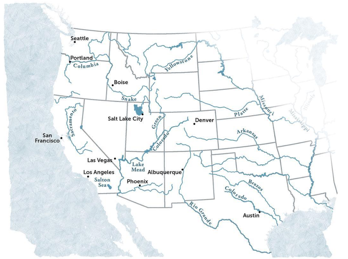
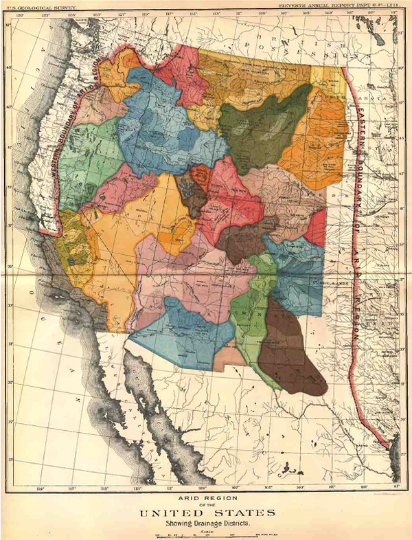
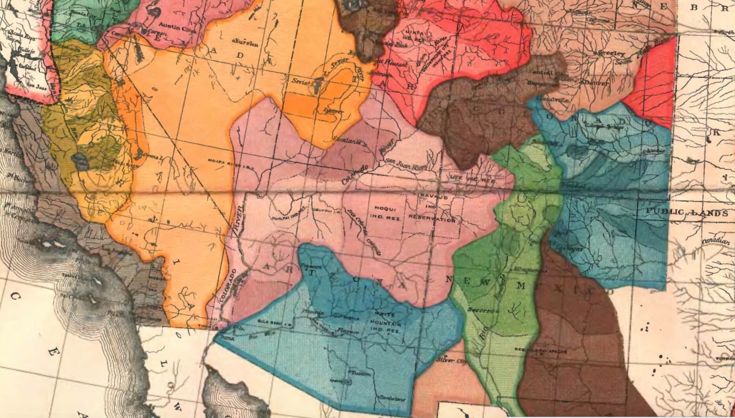
The map may not be the territory. But it shapes one’s relation to the territory–and to the presence of water in the land, as well as the land itself. John Wesley Powell had a clear idea of the importance of mapping the sustainability of his audience’s relation to the new nature of the aridity of the plains states and western territories in the 1870s, when he used his deep knowledge of plants and foliage of the region that was distinguished by a deeply fragile economy of water to try to convince the U.S. Congress of re-organizing the region’s settlement, in the face of increasing hopes for its development: by bounding the area beyond the hundredth meridian west as the “Arid Region,” as if it were a truly unknown land, not subject to the practices of surveying rectilinear boundary lines that the had extended west along the Mason-Dixon line, Powell sought to convey a better understanding of the permanence of drainage zones of the region as the best possible ways of understanding and planning its process of settlement in the way that would be most helpful to future residents, boosterism of the importance of young men going west to find futures notwithstanding.
Indeed, the mapping of how the “Arid Region” of the United States could be settled by John Wesley Powell created as the second Director of the United States Geological Survey, a post he held from 1881–1894, but which he had first expansively described in 1878. The United States Congress followed Powell’s recommendation to consolidate the western surveys into the new U.S. Geological Survey, and he long sought to create a map capturing the fragile water ecology of the American West. The completion of his classic report on the region first suggested a new relation to the distribution of water in the region in ways that would best serve all of its residents, and in his later map, he tried to articulate so clear a relation to the region’s future settlement. Powell’s view on the need for systematic irrigation of the region stands in almost polemic relation to the place that the western states held in the spatial imaginary of the Homesteading Era: indeed, his insistence that led to the charge to undertake a systematic irrigation survey of lands in the public domain of the wester United States in 1888, long a topic for which he had agitated, and his map of the region reflected a demand to integrate a topographic survey, hydrographic survey, and engineering survey of the region. Perhaps the map offered a new sense of the territory, if “territory” includes the waterways that would be able to adequately irrigate all open lands.
For the reception of Major John Wesley Powell’s attempt to map what he called the “Arid Region of the United States” reveals both he difficulty in mapping the relation of water to the land, and the appeal that a piece of paper might gain over time. The detailed map provided something of a ground plan and register of how the arid region might be best inhabited, and of the relation to the land and landwater of a region’s inhabitants. And it provides an early recognition of problems of water management and distribution in the western states–captured in its naming simply as the “Arid Region” as if to set it apart from the plentiful water in other regions–that later eras began to appreciate in ways that Powell’s contemporaries were less able to see in his ambitious attempt to reorganize the management of its regions around its multiple inland watersheds that he had hoped to canalize. For Powell’s ambitious 1890 remapping of lands west of the 100° meridian in the United States tried to encompass their unique aridity and to pose a solution for its future inhabitants with special attention to its drainage districts–as discreet riverine watersheds.
Arid Region of the United States (1890); detail
The best practices that motivated Powell’s map as a basis to orient the government to the land’s groundwater. The distinctive scarcity of water in the western states became evident in a time of sustained drought, giving unexpected currency to how Powell’s map reoriented readers to the “Arid Region of the United States.” The brightly colored map to which the explorer, geographer, and anthropologist not only dedicated an extreme amount of attention in his later life, and of which he became something of an evangelist, suggests a early recognition of the scarcity of water and its management, in an era when there is a specter of considerable anger around poor practices of water management in much of the western states, tempered by an expectation that groundwater would be available for farming and irrigation.
The rivers in the United States are quite widely distributed, leaving much of the western plateaux at a distance from riverine waterways–
–and the image of Virgin Land so deeply ingrained across that regions settlement that its unique character of low rainfall and widely dispersed water sources was erased in the spatial imaginary which replaced the detailed map Powell of the administration of groundwater in the western states that Powell had created with his surveying team as a guide to the region that he knew so well, and which he sought to communicate when he became second director of the United States Geographical Surveys (1881–1894). The governmental office did not give him authority to organize , but to create a new map that might better organize the nation to the lesser rainwater in what was known as the Great American Desert. For Powell attempted to re-orient homesteaders to the imperative of western migration through the map, by organizing water administration and the future prospect for canalization in order to grow prospects for the irrigation of the region and its future farmlands that have considerable ethical power to speak to us today.
We read more maps than ever before, and rely on maps to process and embody information that seems increasingly intangible by nature. But we define coherence in maps all too readily, without the skepticism that might be offered by an ethics of reading maps that we all to readily consult and devour. Paradoxically, the map, which long established a centering means to understand geographical information, has become regarded uncritically. As we rely on maps to organize our changing relation to space, do we need to be more conscious of how they preset information? While it is meant to be entertaining, this blog examines the construction of map as an argument, and proposition, to explore what the ethics of mapping might be. It's a labor of love; any support readers can offer is appreciated!


 Thomas Van Linge/Newsweek/@arabthomness
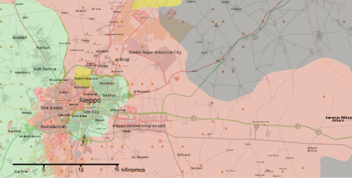 November 1, 2016/
 Thaer Mohammed/AFP/Getty Images
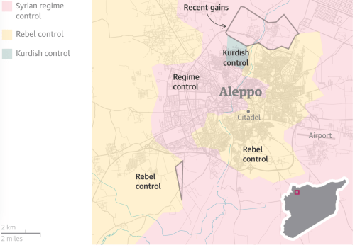


 Arid Region of the United States (1890); detail