
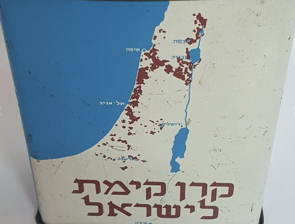
“I am looking at the whole Gaza Strip right now,” President Trump announced, “and it’s a mess. It’s a real mess.” Trump seemed not to consider the scale of American arms’ involvement in its destruction, but to steamroller over any hopes for reconstruction or rebuilding of Gaza for its former residents,–considering that they would be better served by resettlement in other Palestinian nations, like Jordan and Egypt, perhaps pliable to the anticipated demand of the American President. The words Trump spoke to King Abdullah II of Jordan in semi-confidence on Airforce 1 were quickly broadcast throughout the world,–as if wishfully recasting an old Port City that had been under siege from November 2, 2023 between Israeli Defense Forces and Hamas as a demolished lot whose rubble stretched under the feet of the Angle of History, replacing a place of memory with a blank slate,–rather than one 500,000 Palestinians might be trapped. As we face problems of mapping the Gaza Strip after the negotiated Ceasefire, and the transformation of a war zone into a civil space, we are must confront how calls to “Save Gaza” are increasingly being warped to calls for its development by a new American commander-in-chief seeking to insert himself in the war zone as its developer.
Gaza was an empty lot, it seemed to Trump, wanting to be rebuilt better and transformed by a mental imaginary of his own past, bearing no correspondence to the Gaza Strip or any sign of the role of American arms in reshaping the boundaries or escalating loss of life in Middle Eastern politics. What was Gaza? An demolished lot that might be, as any property. It might indeed be a valuable property, a trick to be turned and a deal to be made. The bizarre AI video that Trump would post on social media a few weeks later, imagining the rebuilt Gaza Strip with a soundtrack proclaiming “Donald’s going to set you free,” allowing refugees to escape ruins to frolic on the beach of a resort, seemed to claim to transform the humanitarian disaster to a luxury site for the super-rich, dispelling all concerns for health, devastation, and a shattered infrastructure with an AI image of untold wealth at the end of the tunnel. “I don’t think people should be going back to Gaza,” Trump offered about what was “a phenomenal location on the sea,” contradicting himself by adding “Palestinians will live there. Many people will live there,” as if imagining a Phoenix-like resurrecting a community from the rubble created over a year and half by American-made bombs.

The project of forced displacement of two million was melded with a vision of how the United States would assume its role as a military backer of Israeli’s army, to assume the “long-term ownership” over the Gaza Strip by which it might transform the rubble to an enticing view. On Inauguration Day, as Palestinian refugees were returning to their homes under a newly brokered ceasefire, Trump had proclaimed his vision for a rebuilding in this “phenomenal location on the sea,” a remapping that seemed rooted in his gut, more than , but seemed a reprise of the demolition of the classy emporium Bonwit Teller–but this time less as a tragedy of the loss of an icon of art deco architecture–that he replaced by a kitschy bronzed monument of Trump Tower, as if it were an extension of his own bronzed visage, unconscious that this time tragedy was reprised as comedy.
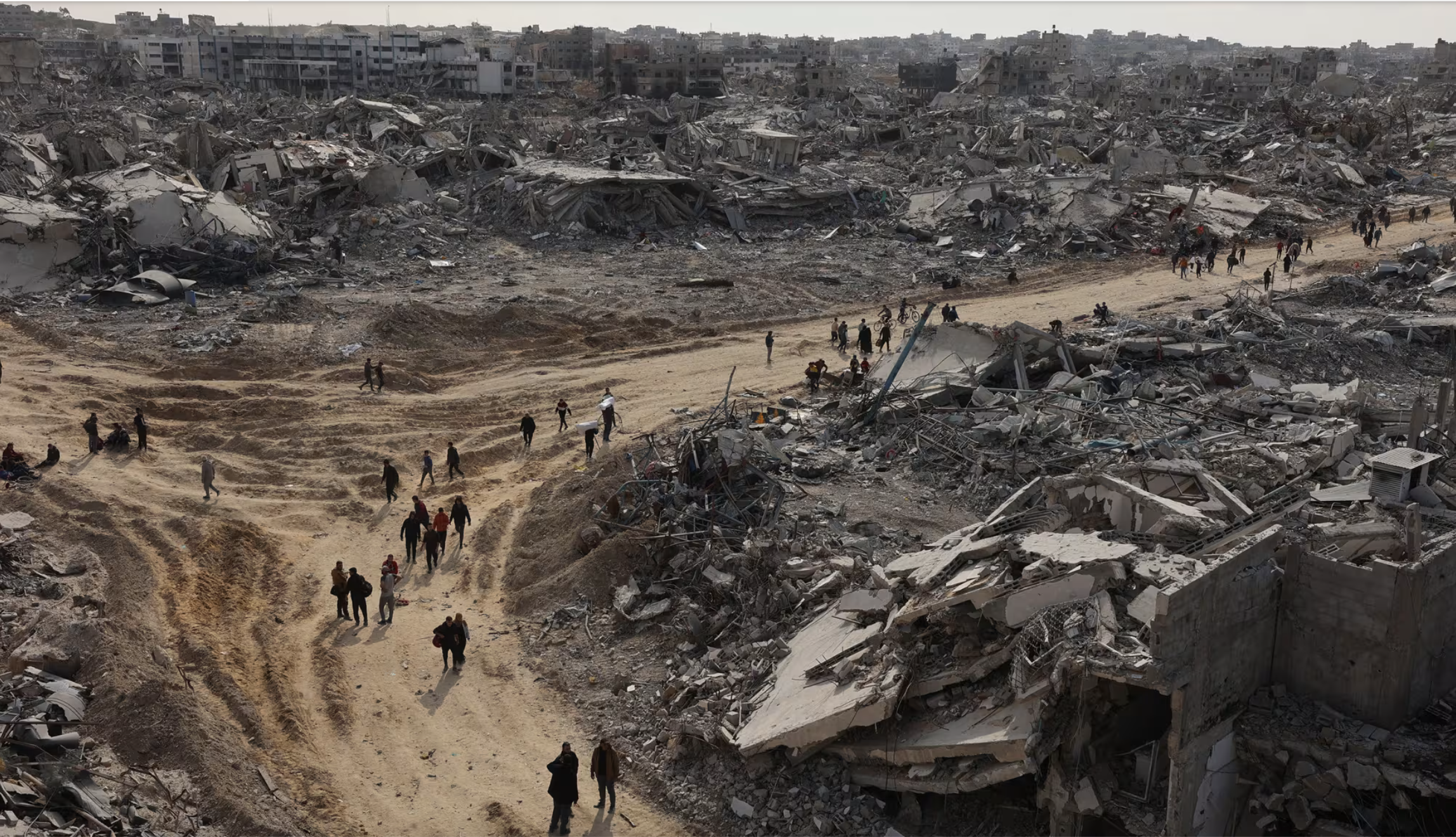
Palestinians Returning to jabalia Refugee Camp the Day in North Gaza, the Day Before Donald J. Trump’s Inauguration/January 19, 2025
Hopes for Palestinian statehood were implicitly “over,” Trump seemed to imply, as if the ruins of the Gaza Strip presented a fait accompli that the world should now listen, as it turned attention to the problem of who would rebuilt the contested area long occupied by Palestinians, and see it not as a contested grounds of war, but transformed to a lot of rubble he must have understood reflexively as waiting to be rebuild, not demanding humanitarian aid. Foreclosing any right of return to Gaza, the city flattened by bombs seemed transformed by eminent domain trumping international law, removing hopes for Palestinian territoriality from the table for bread and circuses, an image of two paunchy white suits making a deal over the situation on the ground that provoked global outrage.

Protesting President Trump’s Gaza proposal in Seoul outside U.S. Embassy, February 5 2025/Chung Sung-Jun
That major transaction that had helped catapult Donald Trump into prime time, as he entered prime real estate in New York City that distanced him from his family’s own Queens-based origins, was a major coup in rezoning laws, which allowed Trump to leverage his ownership over the old shopping emporium with its art deco facade, to create the gleaming gold tower now at home in a sea of midtown skyscrapers that defined Manhattan–and offered the stage, of course, by which descending from a golden escalator, he seemed to define himself as a presidential candidate for an era of steepened wealth inequalities, by refashioning and rearticulating an American Dream that had little to do with education, expertise, and competency, but with leverage of a sort Archimedes never had known by which he, Donald J. Trump, was somehow able to move the world.

President Trump, entering his second term, perhaps overly eager to claim credit for a ceasefire in Gaza, and ready to declare the war that plagued his predecessor at an end. But Trump was purblind to registering the greatest humanitarian disaster of the modern Middle East. And the odd elision of loss of life with rubble, and the prominence of a lot of rubble at the first White House press conference with a foreign leader –“Why would they want to return? The place has been hell!”–reminds one that hell is different for different people, if one often carries one one’s hell with one head.
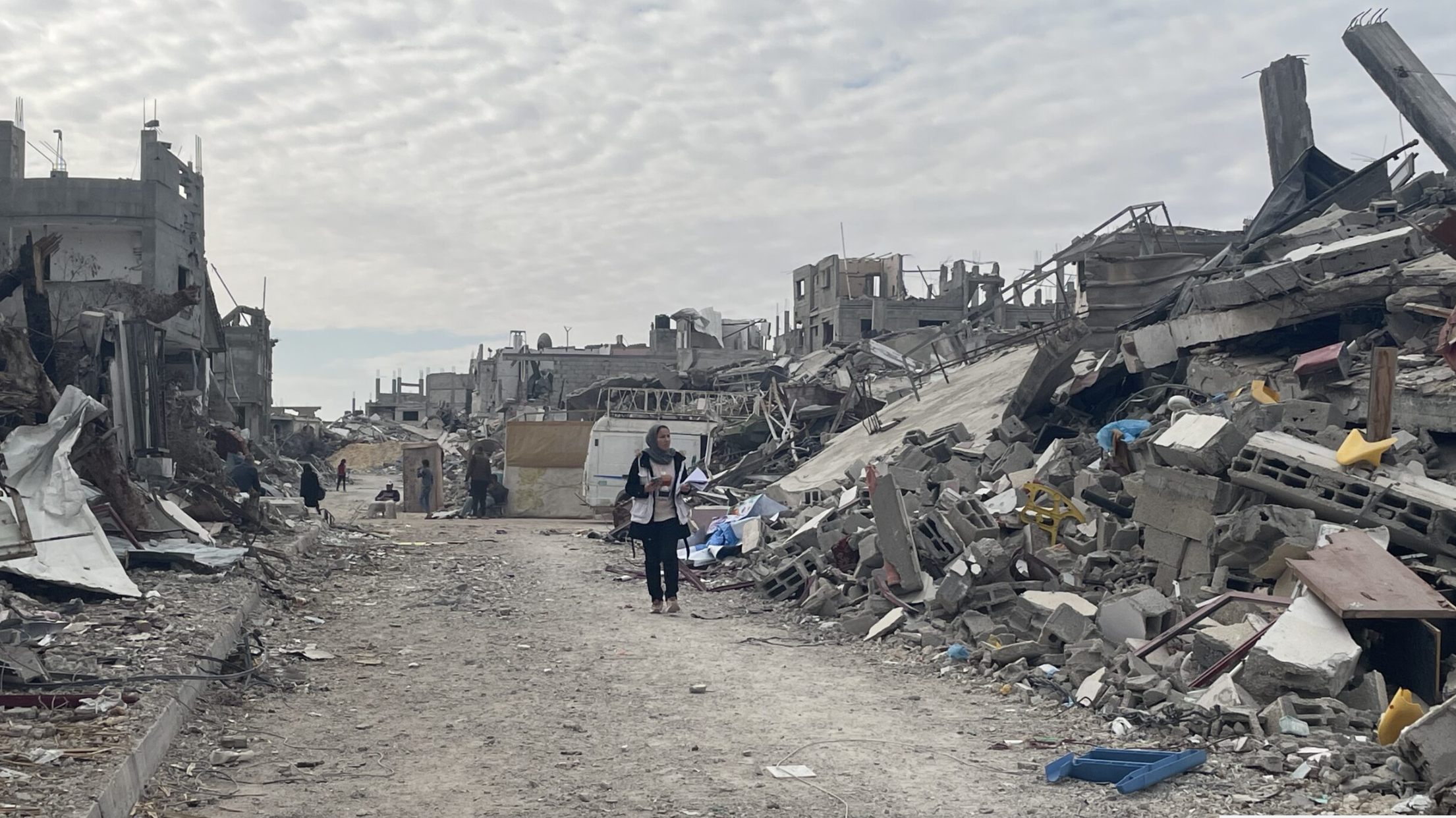
Despite the return of some over 500,000 Palestinians to Gaza since the fragile ceasefire, precarious conditions across the Strip have been intensified with increased cruelty. The prospect to cease the flow electricity that Israel has long provided 120 megawatts to Gaza’s inhabitants on ten power lines on the tails of ending the flow of billions of approved USAID supplies to Gaza. The absence of the flow of the most basic humanitarian aid will hurt displaced mothers, babies, and young children facing needed medical attention–3,000 children facing malnutrition and thousands of pregnant or breast-feeding women, with only ten of twenty-seven health centers in Gaza operational, staffed by stretched and exahusted medical teams by February 2025, after the “ceasefire” was long negotiated: twelve million women and girls will lose access to contraceptive aid in coming months.
The curtailment of 2,300 trucks of needed aid stopped at border crossings since March 1 was followed by ending the flow of electricity to Gaza’s residents on March 9, leaving displaced increasingly vulnerable, living in tents adjacent to homes that are now destroyed buildings, as we approach the holy month of Ramadan, two months after the fragile ceasefire had begun and residents have begun returning to Gaza. Is this coordinated strangulation of the residents of the region not inhumane? Pregnant women and children long bore the brunt of starvation: with 50,000 pregnant women living in such conditions, many displaced at risk of giving birth in unsterile conditions, in rubble and on the streets, at risk of dying from complications, some 400,000 displaced people living under tarpaulins–more than a quarter of its population, per UNRWA, overwhelming postnatal and family planning services in a region where 1.9 million were displaced.
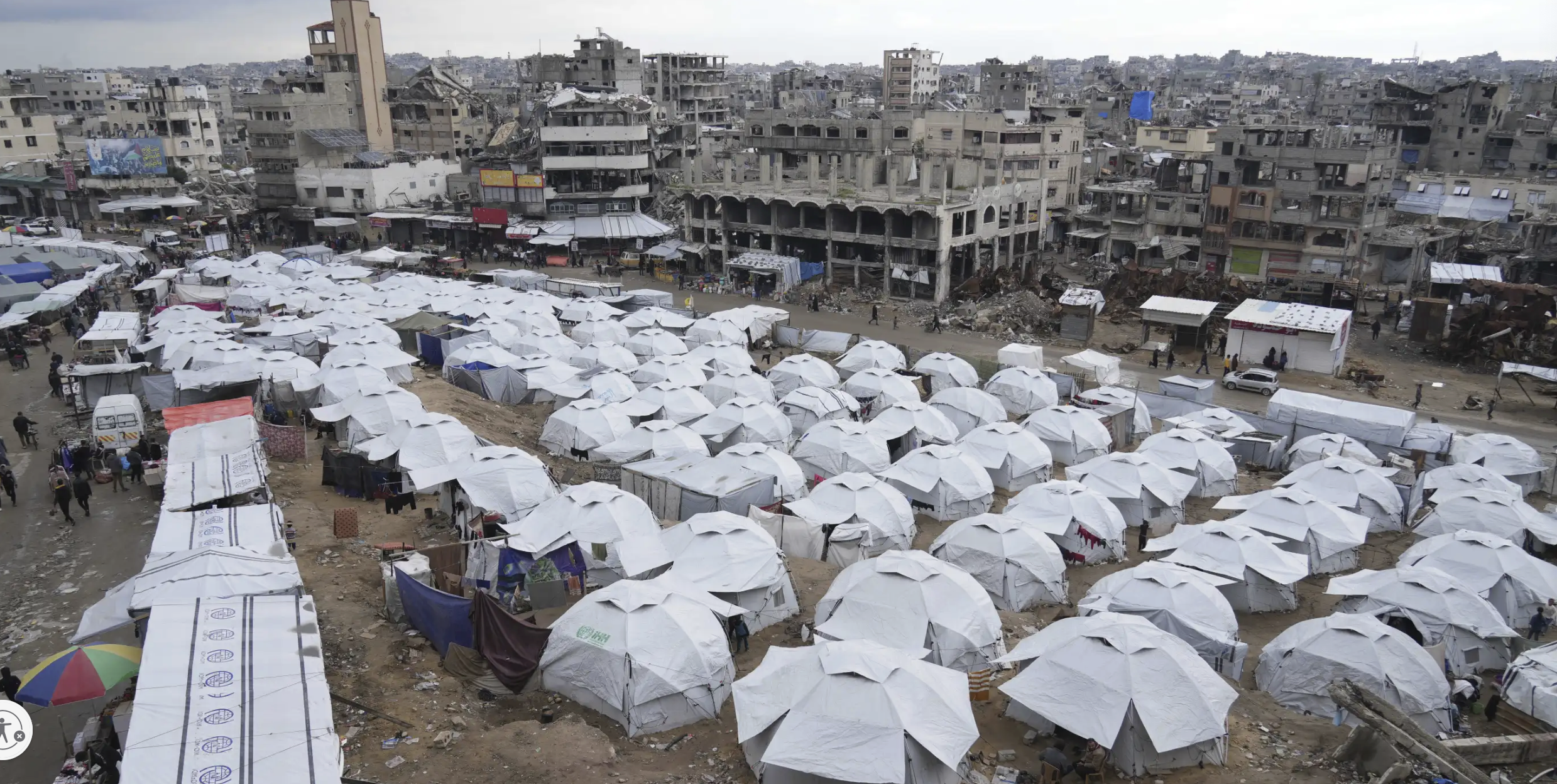
Displaced Residents of Gaza City in Ramadan/March 1, 20205/Gaza City, Gaza Strip/Abdel Kareem Hana
We mask these losses–and challenges–by re-mapping suffering in the region to a lot of rubble, and not including people in our maps, distancing the scale of the humanitarian disaster by a vision of abundance as if to wipe the slate clean with a vision of neoliberal opulence in itself offensive to distance suffering. For the characteristic of the region as rubble mask the contradiction of a return of peace that provides no return to stability. But is a disaster area, lacking water, electricity, water, or sewage lines, in which the most vulnerable women and children have long born the brunt, some sixty thousands of pregnant women are now suffering from malnutrition and ninety percent of children under two years of age face severe food poverty day-to-day. Are these bodies not being treated as rubble, allowed to weaken, wither, and lie without any permanent structures or warmth?

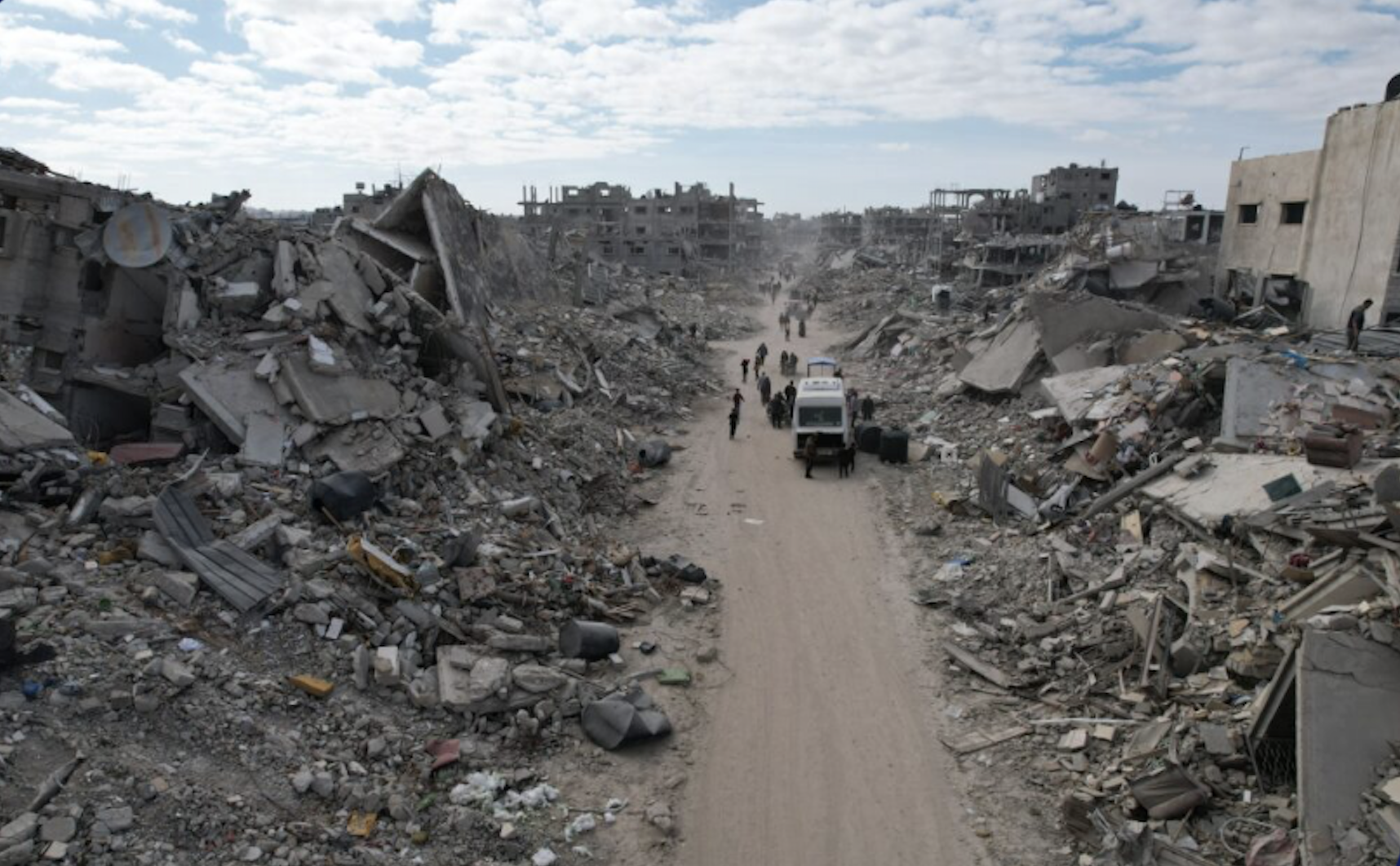
Jabalya February 2025/Olga Cherevko/UNCHA Humanitarian Report
Trump’s words suggest a cognitive refusal to grasp the scale of a disaster that did not involve himself, and readiness to insert himself in the drama of lost lives as a real estate developer, used to rubble, and ready to rebuild “something that could be phenomenal” in its place, “something that could be amazing, the Riviera of the Middle East,” how Trump offered a brutal deal in improvised diplomatic channels immediately taken as an open offense. The refusal that his words provoked of Palestinians living ion the Gaza Strip to exchange that rubble for an “entire city” or “a castle in Egypt or Jordan” among rebuffed Trump’s words so keenly because the proposal not only adopted a right-wing Israeli belief that Gaza is not a Palestinian homeland, but erased a historic site of residence in calling it a lot of rubble, as if to foreground the fungible nature of Gaza City.
Trump’s boast recalled to this New Yorker the very fungibility of the landmark building in New York, once occupied by Bonwit Teller, more than having a historical significance for its inhabitants. As much as it reflected a tactical plan to render life in Gaza City so unlivable to force Gaza’s residents to leave the region, the topos of “rubble” immediately disenfranchised Palestinian inhabitants from the region. In offering them a “deal” of other unbuilt residences and promising to rebuilt a “new” and better development in its place, a promise that seemed more of a con man or realtor than a national leader or a President. For the boast that Trump made to rebuild an area he would “own” suggested the site that he purchased on 721 Fifth Avenue, far from the Middle East, that he proceeded to convince the City Council to rezone for residences, before demolishing the art deco building that he had pressured the company to sell for $15 million by January, 1979, persuading that Council that he would cease to rent the art deco skyscraper to the sophisticated luxury store for upper-class customers if it were not rezoned–and proceeded to reduce to rubble, including the stylized art deco relief sculptures and art deco artifacts he denied to preservationists, in what became the grounds for retail and commercial areas, offices, and thirty-nine floors of exclusive luxury residences, before its penthouse suite served in 2016 as the White House North.

The transformation of the building’s bronze-colored glass facade skyscraper he commanded his architect create was an intentionally showy, luxury footprint that sought to change the skyline of New York, with “flash,” at a far remove from Gaza’s inhabitants or arid sands. The conflation of the two places–the future of a built towers destined for the 1% and the rubble on the ground today in the bombed out site of Gaza City–was thematized in the AI video Trump promoted on TruthSocial–as broken down towers morph into a rebuilt exclusive beachfront paradise of soaring luxury towers, lined with palms, and without fear, was at a remove from the historical origins of the Arab presence in Gaza, as its minarets are seen behind luxury shopping spaces replace the residents’ suffering, as if the tenants who live in and occupy the building Central Park South building that became Trump Tower could be evicted and displaced. The spectacle of the magnificent building would arrive to obliterate all needless suffering that would erase the all too squalid past.

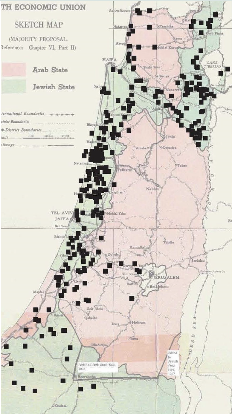
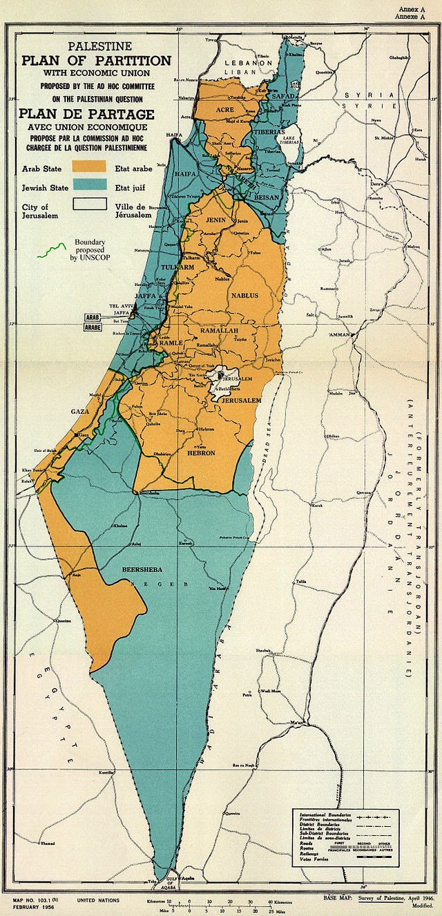
Gaza City and North Gaza in the British Mandate Government (1945)
Ready to flip the region to real estate lots, was Trump actually replacing international diplomacy and law to the hard bargain of Manhattan real estate markets of the 1980s, seeking to strong-arm a sovereign by the logic of real estate? He seemed to ask the world to imagine the Gaza Strip as a real estate parcel, and stop thinking about the people who lived there–indeed to realize that this rubble was destined for the site of rebuilding so that a phoenix might arise from it, akin to the rebuilding of the Bonwit Teller building that he purchased and had rezoned from a commercial development to a residential tower of luxury condominiums might effectively transform the contested land by fiat, as he had forced the construction of Trump Tower through the City Planning Commission, who he told “if I don’t get a zone change, I don’t rent to Bonwit Teller,” already imagining the luxury duplex he might build at the top floors of the monstrous building he had rendered before destroying the Art Deco landmarked building that had long occupied it for a new monumental project that would mark the start of “the monumental projects” he decided to dedicate himself by 1980–“not like the junk I destroyed at Bonwit Teller” that had so flipped aesthetic values of public architecture, its concrete superstructure clothed 3,800 tons of steelwork by a concrete superstructure more solid than the steel-framed architecture of skyscrapers. The erasure of the suffering and human rights crisis that Trump is unable to see or even detect suggests an extreme pathology, but an unhinged relation to the global map, building on a Presidency that promises to allow us not to see suffering, not to see displacement or refugees, and to detach America from a prominent position in the world.
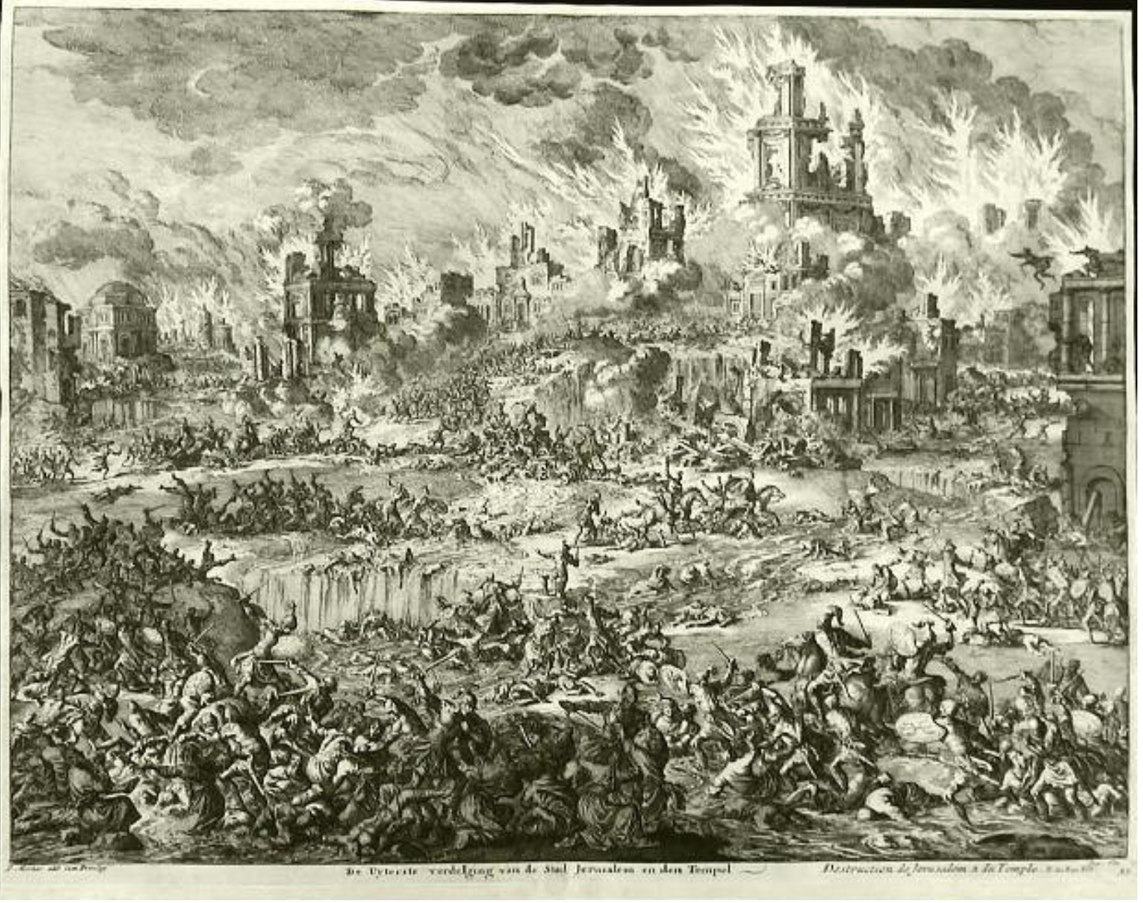
The rubble that he saw in Gaza as an uninhabitable site of misery was a site of misery for many who had died there, or were still buried under its concrete rubble, but the concrete would be cleared, and replaced by steel structures he might build in their place. As the concrete of Bonwit Teller were cleared and soon forgotten, despite their iconic value, the flattening of history seemed sanctioned to Trump, as if the ruins of Gaza had crashed at the feet of the Angel of History who was born forward on winds, toward the future of the new Riviera of the Middle East.
Rafah Immediately after Hamas-Israeli Ceasefire Agreement/Ashraf Amra/Andalou
The header for this post was not only a pronouncement that the Hamas’ authority on the Gaza Strip is over, but the hope of Palestinian sovereignty is over, that the Two-State Solution is at its end, but that the refugees you heard about were no more. So declared Donald Trump and Benjamin Netanyahu at a joint press conference that opened the possible eviction of Palestinian refugees who had begun to return to there home after the recent Ceasefire for which Trump had, weeks ago, eagerly taken credit. Israel and Hamas had proposed multiple humanitarian ceasefires in the past, and the United Nations had called for decades, ineffectively at best, demanding the “immediate and unconditional ceasefire” in hopes to work toward “a durable and fully respected ceasefire” on humanitarian grounds. The hopes of the ceasefire became a building opportunity for investment, a question less of borders, or refugees, or humanitarian interest, as the building Trump Tower by topping fifty-eight floors of concrete–45,000 cubic yards!–to encasing four thousand tons of steel.
The ruins might be consigned to the past, and replaced by a worthy monument to fun in the alchemy of construction. The heightened level of destruction of so many IDF bombs–and prospect of a delivery of more powerful bunker-buster bombs to Israel in coming months–hoped to strong-arm the Middle East to finally map an absence of sovereign claims neither Trump or Netanyahu had never hinted might ever map in the so-called Peace Plan of 2020. As if it were long-established consensus, Tump’s spokewoman asked if “people should live in such dire conditions” that seemed a truly “uninhabitable place for human beings,” suggesting that this region in the Middle East had been rendered uninhabitable, a non-place of modernity, as Trump painted the possibility of a future plans for Palestinian resettlement, “if we can get a beautiful area to resettle people, permanently, in nice homes,” in the language less of a statesman than real estate developer. The Gaza Strip, so long celebrated and fought over as a site for a Palestinian homeland, was “an uninhabitable place for humid beings,” as if it were a torrid zone from medieval maps, in a band that was parallels the equator and lay beyond the human ecumene. This was not about human rights anymore; this was about the transformation of the most densely-inhabited area of the earth to a wasteland removed from governance..
The United States elected Trump to make sure we didn’t have to think about people. Trump was promising that we don’t really have to care about others, or even think about people: much as he promised to deport immigrants or refugees in the United States, and suspended refugee admission on the first day of his presidency. The declaration of January 20 he was “Realigning the United States Refugee Program,” by suspending the US Refugee admissions policy and refusing to accept refugees in America as they were “detrimental to the interests of the United States.” The rejection of a policy on refugees paved the way for the fluidity of the Gaza Strip, and the fluidity that the boundaries of Ukraine had at the end of another war he claimed to end,–leaving a tenth of the Ukrainian population, including 1.5 million Ukrainian children, under Russian rule. In a single news conference and on television, his preferred medium, President Trump had closed the door on the future of a Palestinian state with particular cruelty–there was just no place for it on the map, but we should stop even thinking about it. That was not the spectacle he wanted to focus on, and neither was the spectacle of the Palestinians in Gaza–or the Ukrainian refugees who would stream into Europe, fearful of future prosecution, or the unhoused in America, or human rights refugees.

What Trump was looking at as he was watching the “whole Gaza Strip” wasn’t ever clear, and it didn’t need to be. There was literally nothing to be seen there–just devastation, an a mess that was not worth thinking about. Trump’s declaration about the Gaza Strip seemed a prelude to the dissolution of a hoped for armistice shortly before he took office, as if that long process of negotiation that tried to offer a careful path forward to sovereign coexistence and military withdrawal were a ridiculous proposition to imagine. Despite traded accusations of violations of the Israel-Hamas Ceasefire, Trump escalated a rhetoric of bullying, as if he might force Hamas and all Palestinians from Gaza and dismiss claims of Palestinian sovereignty out of hand, claiming the Palesitinians at this point just didn’t have any place on any map: Netanyahu, who had allowed only enclaves of Palestinians without a state to exist in proposals of the previous six years, seemed to be delighted at the result of Trump, nudged by his financial backer, Miriam Adelson and the American right. It was about “protecting the meaning and value of citizenship.” It was not only bluster, if it left the world open-mouthed.
The map hadn’t changed much in Ukraine for years, but Ukraine as we know it seems to soon maybe not exist on the map, after a future press conference with Vladimir Putin will likely announce its newly drawn borders, after a war of attrition seemed to be shifting the other way.
Sovereignty may seem to be up for grabs in the regional map and in the global map, in a not that new spin on globalization. Trump may threaten to invade–or occupy–but to take any pathway to statehood off the map. The future of a Palestinian state indeed seems to be far more up for grabs than during the war. Then again, so does the Gulf of Mexico: that body of water’s renaming may be but a prelude to America’s assertion of its rights for underwater prospecting in the region,–and allowing American petroleum industries not to imagine the notion of Mexican territorial waters. If ten percent of Ukrainians who will be living under Russian sovereignty for the near future suggest the fluidity of borders and the U.S. Secretary of Defense calls the borders of 2014 “unrealistic,” we don’t have to care about the people who live in those borders. They are non-nationals, stateless who are as far from American interests as can be.
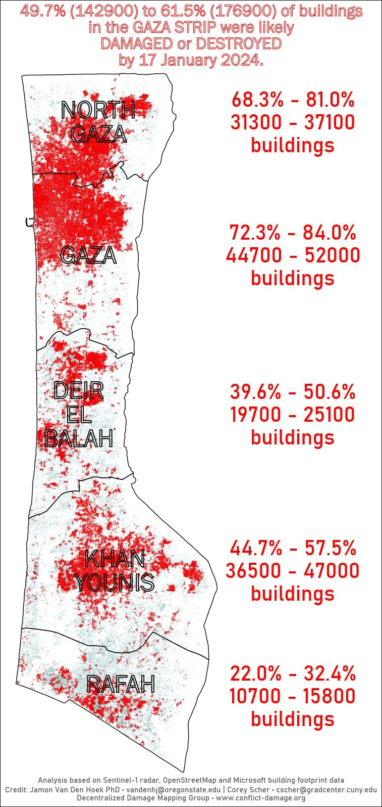
The fate of Palestinians seems more abruptly decided indeed: why don’t they go somewhere else? The stateless do that, and 700,000 Palestinians did in 1948, when Israel was founded. Rather than propose control of a zone by peace-keepers, the prospect of displacement of two million seems easier after destruction of over 90% of residences during fifteen months of bombardment or armed invasion has destroyed local infrastructure in ways that offer little point of orientation to a landscape that defies mapping.
Trump’s claims in semi-private confidence were of course broadcast to the world, and occupied the spectacle of Gaza’s ruins. The shift in spectacle–that of imagining the invasion and occupation of the region by America–was eery. Because it adopted or used the terrifying language of spectacle that he had adopted when promoting Trump Tower, forty years prior, using the destruction of lots of real estate to describe the Gaza Strip as if its rubble might be valuable beachfront property. The confusion of categories—not loss of life, humanitarian need, hunger, medical emergencies, bodies buried under rubble–raised the basic question of what map or drone footage of Gaza he was looking at exactly–even as footage of destroyed homes and buildings were intercut with a news conference Middle East, forcing Egypt and Jordan and Bahrain to accept refugees that would compromise any opportunity for Palestinian statehood, at the very time that displaced refugees try to return to their destroyed homes and neighborhoods utterly unrecognizable after near-complete aerial devastation.
Nadia Abu Malloh in the Ruins of Rafah City in Southern Gaza City/Medicines sans frontières, 2025
The announcement that came quick on the shuttering of USAID suggested that rather than help any refugees with reconstruction, the United States’ intent to ensure there was no presence on the map of Palestinian sovereignty, and Hamas would be expelled from the region. What had been sovereign bounds were transformed into a war zone where past ideas of sovereignty did not exist, erasing the boundaries of Gaza that Israel had staged its ground invasion, as if the Palestinian refugees that entered Jordan, and Egypt, which was suddenly responsible for the Palestinians living in the Gaza Strip that they seized in 1948 in the first Arab-Israeli war.
Those displaced by the Gaza War would be resolved by sending more stateless able to gain Jordanian citizenship and be welcomed into Egyptian universities, despite destabilizing of forcing stateless to enter either nation from Gaza or the West Bank, and the utter disinterest it reveals of the Miiddle East’s instability, and dismissal of a future two-state solution as “a reward for terrorism.” With all funding for reconstruction in the Gaza Strip suddenly placed in jeopardy, and taken off the table, the war continues a year after the majority of building in the region had been destroyed–and all monuments, landmarks, and many orienting signs have been destroyed, creating a true sense of immediate local disorientation, with neighborhoods flattened beyond recognition.
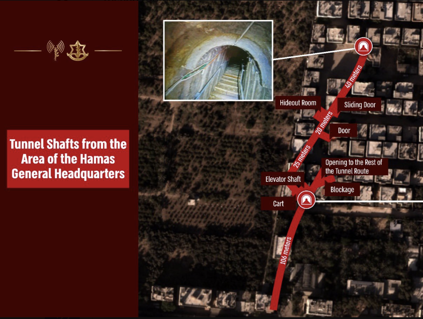
Decentralized Damage Mapping Group/analysis based on Saentinel-! radar data, OSM, building footprints/ James Van Den Hoek and Robert Scher
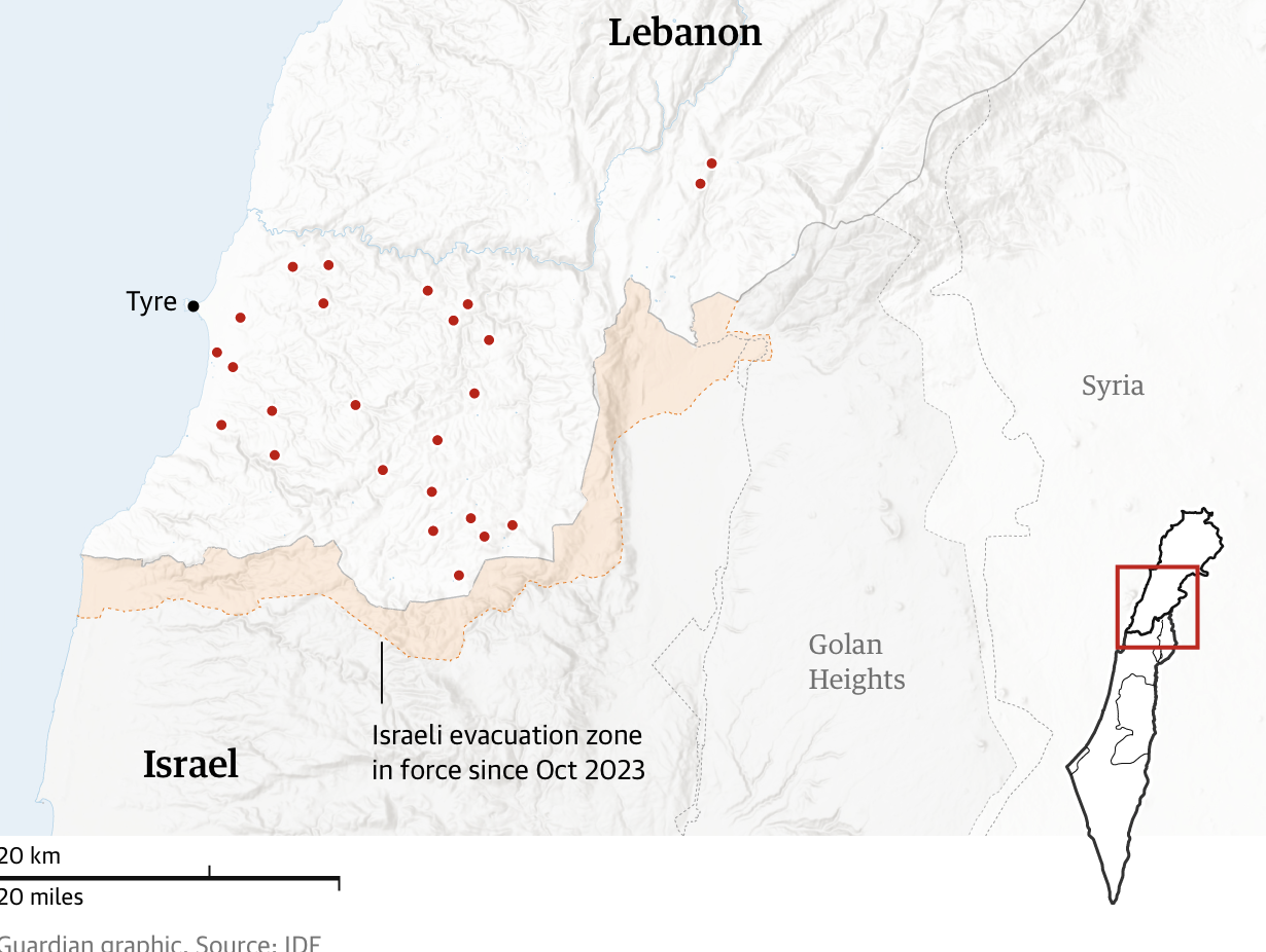
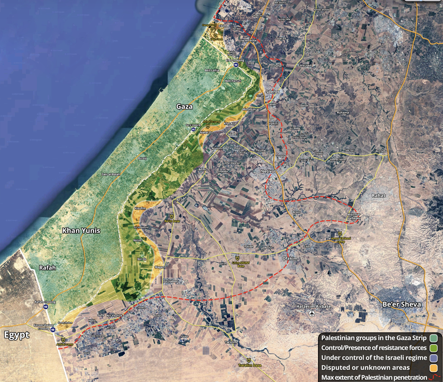
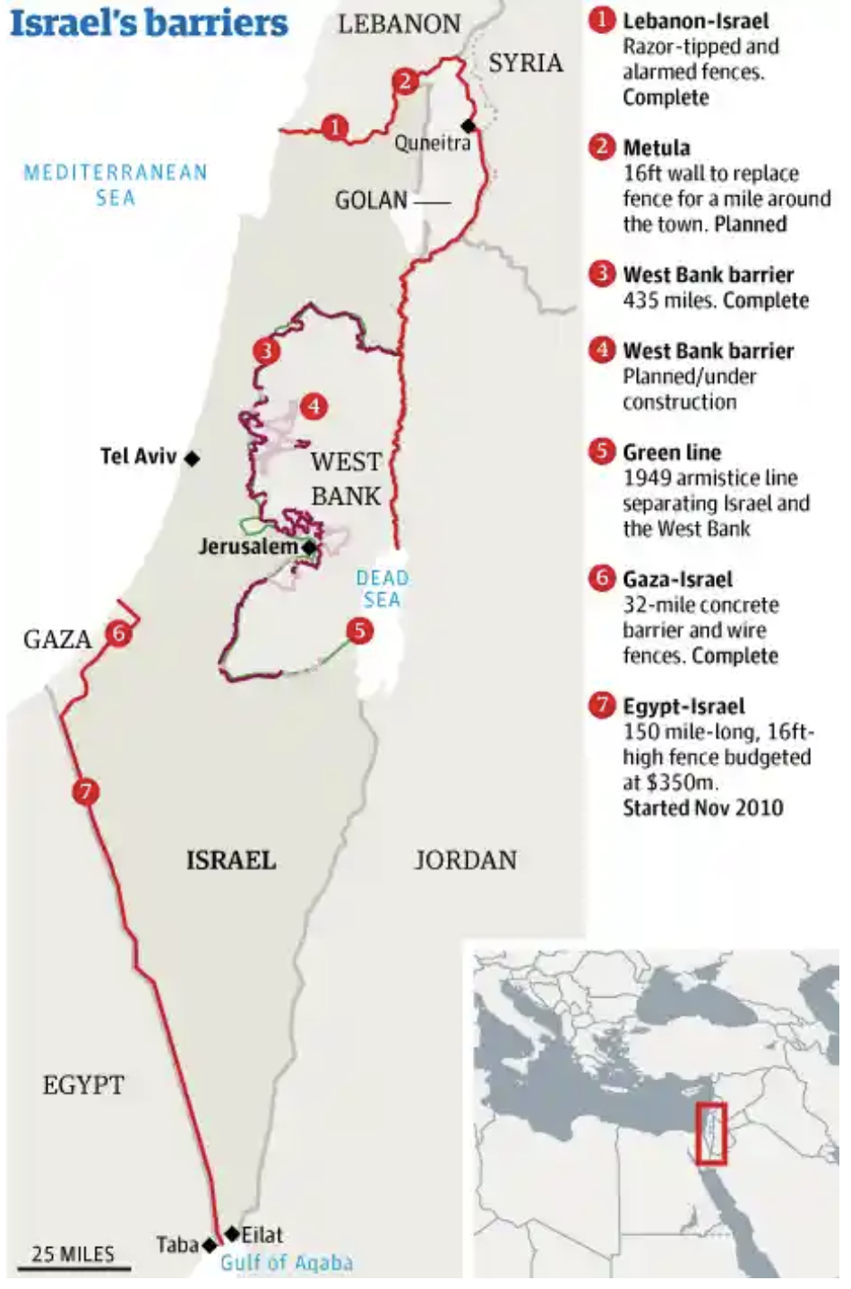
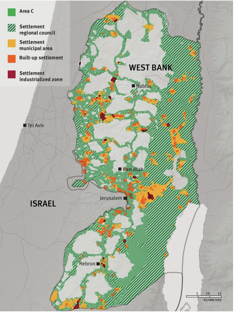
The sick travesty that what remained was only rubble–and merited no attention for local claims of habitation to its residents–deflated any talk there had been of enacting a Marshall Plan for Gaza. The question of political control of the Gaza strip was placed into un certianty in the announcement at a press coherence with Netanyahu that America was ready to bully “Arab” states to accept the absence of any Palestinian sovereign bounds in occupied territories–and the erasure of the sovereignty demands to be mapped. In erasing the boundaries of sovereignty in the Gaza Strip, Trump tried to bully the global stage by evoking Gaza as mere rubble. Israel, a year later, for its part had refused to allow displaced Palestinians even to enter the “strip” that had been decimated, waiting until further Israeli hostages taken by Hamas were released–as if the clearing operations that the Israeli army had undertaken in the blue dotted lines below had relegated past inhabitants’ right to the place they lived by converting them to archeological sites to relegate them to the past.

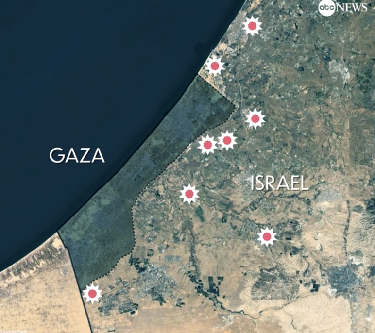
Israel-Hamas Ceasefire Lines/January 25, 2025/Institute for the Study of War
The President announced he had spoken to the Jordanian King Abdullah II as monarch to monarch, rather than as a leader of the Free World. It was clear suddenly that during Trump’s second term, , he was more than ever apt to empty the land of people, and to treat space as fungible real estate to which no other nations or peoples had claimed–and that they might as well be stateless, as the Palestinians. For it just might be time to “just clean out” Gaza, forcing its inhabitants, whose suffering under American munitions and arms showed they had little “luck” in the region, to decamp for brighter pastures, and leave the beachfront Riviera to the map with the plan, which would not allow any space for the reconstruction of what used to be there at one time, or the hopes for sovereignty that were long rooted in residents’ minds that they had refused to leave until the local infrastructure had collapsed. This was a sense of unreality as the Palestinians who had fought for statehood–a Right of Return–appeared as if they might be displaced from their homeland. That hope seemed over–and the very idea of a two-state solution as well.
Trump’s assertion to the assembled press corps does beg the question of just what maps of Gaza or aerial photography he was just “looking at,” and what sort of spectacle he wanted to suggest exist in place of the destroyed landscape he dismissed as an empty lot of rubble. It was evident to all that there was no actual plan that he had revealed or disclosed–an American entry into Gaza, displacing refugees who had recently crowded its beaches, in search of assistance and shelter, with 80% of the residences dietroyed by bombs and materiel that America had sold to Israel. This was described as a deal he had worked out in advance, and sought to impose on the complicated map of the Middle East, but was reminds us more of the very transactional politics by which he approached diplomacy in the Middle East in Trump I, now on steroids as a purely transactional exercise of deal-making.

Displaced Refugees Crowded along Gaza Beach
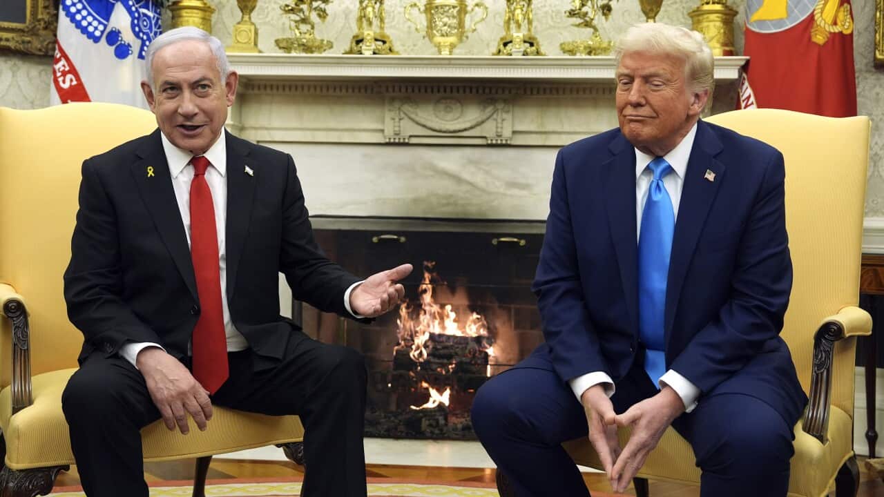
“You’re talking about probably a million and a half people,” Trump said, referring with skepticism to what he saw as a relatively small number of residents to occasion a global outrage. “And we just want to clean out that whole thing, and say–you know, it’s over,” seeking to turn the corner on the Middle Eastern tragedy and to strong-arm Israel’s neighbors to just put up or shut up, and accept more refugees within their borders, as if the clean-up mess was just overdue, and it was time to “clean out” the Palestinian residents, historical shadows of forced migration and ethnic cleansing aside for the moment, and eager to release his predecessor’s hold on the sale of 2,000 pound bombs to Israel. The sense of treating the land as a real estate lot, suggesting the Gaza Strip had become a territory “nobody could live.” It was clear he wasn’t really looking at a map,–but there was a sense that he had finally considered it time to look at the spectacle of the destroyed Gaza Strip broadcast worldwide. The spectacle of the destroyed houses and bombed-out buildings was perhaps the point. “Gaza is not a place for people to be living,” Trump ominously declared, on the eve of hosting his first official state visit in his second Presidency–at least,-until it was suitably developed. And remember those bombs? Israel’s already bought them from the United States under his predecessor, and “They’ve been waiting for them a long time.” Netanyahu bore his White House smile, after the state visit had ended, grinning far more broadly even than after earlier meetings with Donald Trump.

The broad smile on the Prime Minister’s face at the press conference betrayed full satisfaction,–not only as a satisfied customer, or a client with his confidence man, but as one of two confidence men, far deeper than the smile with candidate Trump in Trump Tower’s gilded chambers, back in 2016–

Candidate Trump Meets Benjamin Netanyahu in Trump Tower, September 25, 2016/Kobe Gideon (GPO)
As they posed for photographers before the White House, after Trump had promised to find some enticements to attract Palestinians to leave Gaza, a long dream of the Israeli Prime Minister, as if it was an unexpected outcome of his visit, Netanyahu smiled like a Cheshire Cat, so that the smile seemed to be left hanging even after the photo session end, a smile that was a bit of a smirk, at the edge of his chair as if he couldn’t believe his luck, either during the talks in the White House–
February 4, 2025/Evan Vucci/AP
or by the time he left the White House, as if with a gift that he had hardly imagined barely within grasp, even if it was at an absurd distance from the displacement of refugees they had imagined, a reality far from the White House, whose implementation was yet to be defined. “It’s right now a demolition site, this is a demolition site, virtually every building is down, they are living under fallen concrete that is very dangerous and very precarious,” Trump told an audience of reporters, in which the “only reason” the displaced refugees even wanted to return to the bombed out region was because they had no “other alternative“–and he was going to be able to provide them one. And whatever the borders of the Gaza Strip and the rights of residence guaranteed its residents, only a “long-term ownership position [by the United States] would bring “great stability to the Middle East.”
Netanyahu was smiling ecstatically. His army having reduced Gazato rubble, destroying a fifth of its permanent buildings and 85% of its homes, bunker-buster bombs would be soon on their way, as the smoke was rising. The verdict of the International Criminal Court had charged Netanyahu a war criminal be damned. (President Trump was happy to thumb his nose at the International Criminal Court than Gaza’s refugees, when he decided to invite Netanyahu as his first state visitor to announce a deal on Gaza, also no doubt allowing Netanyahu to miss a court date–and jointly endorsing the war crimes a forced migration of Palestinians from the long-time homelands of the Gaza Strip, where they had lived since Israel’s independence. The spectacle of the sanctioning of war crime flouting the norms of international law, and the international Criminal Court was cast as a victory of national interests over international ones, and against the global interests perhaps incarnated at this point only by the United Nations and ICC. (Was Trump reminding that court that released its warrant November 21, 2024, of its continued lack of jurisdiction in the United States, and perhaps reminding the world how little he considered laws as valid, international or national?)
What was a bedrock of international law was cast as irrelevant before the brute reality of the post-invasion devastation of the Gaza Strip, where the absence of any ability to map the ruins of residences let Trump to question the interests of the Palestinian people–“I would think that they would be thrilled” to move!–as if the end of Palestinian sovereignty in Gaxa and the West Bank was a foregone conclusion, and the real estate value was degraded, beyond the possibility of rebuilding, unless the region were flipped, by the practices of good real estate managers, to a Riviera of the Middle East–a place where only the UAE is seeking to open up longstanding gambling laws–as if the casinos of Israel or Lebanon, and the options for gambling to tourists available in Jordan and Egypt, and the future casinos of the UAE, might be extended to Gaza to develop the current ruins.
The idea of replacing the ruins of Gaza as a true “Riviera of the Middle East” with a range of options of resorts and casinos was lampooned by the current Secretary of State Marco Rubio back in the 2016 Presidential primary–“The Palestinians are not a real estate deal, Donald!“–but now seemed to backtrack on this issue, insisting that the President of the United States was a pragmatist, whose position “was not meant as a hostile move.” Behind the scenes, perhaps Trump saw the loss of Hamas’ gamble to stage the October 7 attack on Israel to retake the Al-Aqsa mosque and East Jerusalem met its conclusion, in the pragmatic opinion of a past owner of several casinos in Atlantic City long-time associate of casino-moguls Sheldon and Miriam Adelson, to cast Hamas’ “gamble” of sovereignty in the Middle East as merely a badly placed bet–

Grok AI
–that might be best understood as a way to rebuild Gaza not, as President Biden imagined, by tools of governance and reconstruction, but rather by undermining international law or institutional support, seeing it as a “pile of rubble” as a demolition site to develop and rebuild.
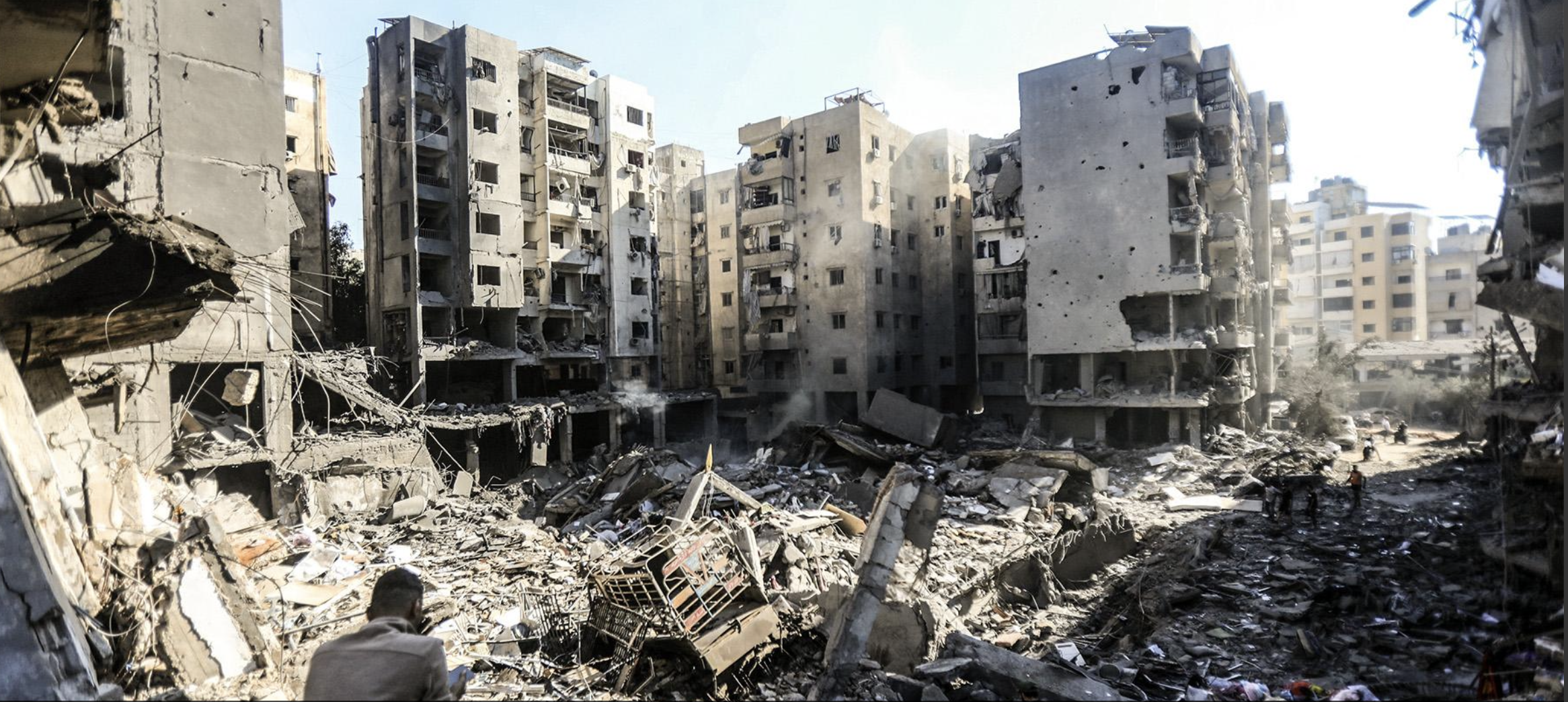
The ruins of Gaza had no future for its former residents, who had no right to imagine let alone claim sovereignty over the land where they once lived, as their habitation of its was misguided and came to no good. The footage of the demolished regions of Rafah, the southernmost city of the Gaza Strip, of Gaza City, or of destroyed refugee camps that were targeted as site where Hamas was sequestered, were so thoroughly destroyed by US-made bombs over the past decade, even as journalists were denied entry, that the images of bombed out landscapes that seem uninhabited and uninhabitable seemed to have been replaced with rubble, an utter demolition site to which former residents had no rights to occupation or rebuilding.

Destroyed Buildings in Jabalia Camp in Gaza City/October 23, 2023/Yahya Hassouna, AFP
“You know, it’s all rubble,” Donald Trump mused as a confidence man from the Oval Office, reminding Palestinians that they really at this point had no choice but to look elsewhere for a homeland, and would be happy if they did–even after enduring aerial bombardment in the houses that were once a flourishing, if crowded, community–as they just hadn’t been that lucky after all in Gaza, a place they had no real future. Trumped seemed ready to unbalance the precarious nature of the Ceasefire Agreement that Israel and Hamas had recently brokered, with considerable United States help, which he once claimed credit fro: “all hell would break loose,” he predicted in two days, if the Palestinians did not accede to demands to release all prisoners, and leave the region whose map and ground plan seemed left without guideposts or remaining infrastructure to rebuild, as if it might be understood as a clean slate and a resolution to a grim future its residents must accept.

Rafah After Hamas-Israel Ceasefire Agreement, Ashraf Amra/Andalou
Sitting comfortably behind the Resolute Desk to met with Netanyahu, Trump used the first state visit since the election to show the world that the visit was not only an excuse for Israel’s Prime Minister to skip a date in court, but to flout it. “They have no alternative right now. I mean, they’re there because they have no alternative. What do they have? It’s a big pile of rubble . . .”

Khan Yunis, July 31, 2024/Hassan Jedi
Rather than seeing Gaza as a site of needed humanitarian aid after the Ceasefire Agreement that he claimed credit for having brokered was signed, going into effect the day before his inauguration, on January 19, 2025, he ended expectations of allowing the entry of humanitarian assistance to the Gaza Strip. Even as movement into and out of Gaza was allowed at opened border crossing, allowing plans for the region’s reconstruction and an eye acted rise in humanitarian relief, as well as the ceremonious exchange of mortal remains, before rebuilding homes, with a promised 600 trucks arriving per day and fifty trucks of fuel, with three hundred trucks heading to North Gaza to encourage the return of displaced Palestinians, Trump was telling the world that rebuilding might not even occur on his watch. If a bulk of the support for the people of Gaza had been arriving since 2021 via USAID, and the organization had promised $230 million for the West Bank and Gaza in November, 2024, as Joe Biden was leaving office, the substantial aid that had arrived for water sanitation, infrastructure, and governance, as well as cash flow, had been put on hold as the agency was in the process of being drastically reduced and all awards and support were cancelled, and over 5,000 foreign aid officers reduced to a rump of 290, and all foreign support contractors furloughed.
And so, although he acknowledged that he, Donald Trump, was quite a busy person, he would be talking to “various and sundry other countries“–his way to reference Jordan and Egypt, playing a tad better than “shit-hole countries” on the air–to make sure they would take in the Palestinians who could be bribed to leave Gaza, and maybe given an enclave elsewhere, “a lot better than going back to Gaza.” The hope may well be that these nations, which depend on US Foreign Aid, can be used by the latest form of global bullying at Trump’s disposal to be strong-armed to accept refugees who lack a home. Indeed, as Israeli Defence Minister Israel Katz ordered the army to develop a comprehensive plan to facilitate Palestinians’ permanent “voluntary departure” from the Gaza Strip, in quite open violation of forcing the movement of people living under military occupation by the 1949 Geneva Conventions, Netanyahu, who has already been judged a war criminal by the International Criminal Court, has endorsed the prospect of a mass emigration of Palestinians from Gaza praised Trump’s plan of developing the region as quite a “remarkable” idea.

Displaced Palestinian Children Look at Destroyed Buildings, February 6, 2025/Bashar Taleb AFP
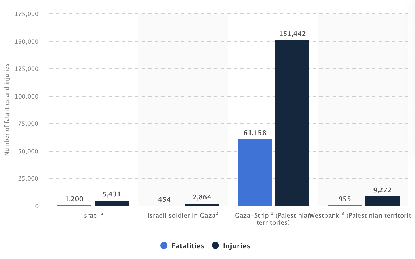
The density of aerial bombings created far, far more deaths than Arab-Israeli conflicts of the previous fifteen years, and an astronomical measure of deaths per sq. feet if that metric existed, and “excess deaths” of starvation, and deteriorating psychological, infrastructure, and health services–by conservative estimates surpassing 67,000.–normalizing a level of violence rarely seen concentrated so intensely into a compact war zone able resembling an actual demolition site.

Rafah, Gaza Strip, Tuesday, Jan. 21, 2025
Continue reading


