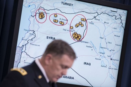
Maps offer a unique tool to display the relation of power to territories, and the use of a magnified map of Syrian airstrikes performed a useful function in the news conference of Defense Department Spokesman Rear Admiral John Kirby. “We hit them [in airstrikes] last night out of a concern that they were getting close to an execution date of some of the plans that we have seen,” said Attorney General Eric Holder–whose tenure at the Department of Justice must have been more consumed by approving surveillance activities than he had expected–on the eve of his resignation from the Obama Administration. Using such a circumlocution was tellingly (if not intentionally) obfuscating, in ways that may acknowledge the prominent role of the Department of Defense in the decision to launch such airstrikes. For the Attorney General–whose tenure at the Department of Justice now seems more consumed by approving surveillance activities than he ever expected–boasted about successfully delivering a round of airstrikes of Tomahawk missiles into Syria.
The map’s finality effectlivly obscured the problematic legal status of launching the airstrikes. Holder omitted that planes fired into Syrian territory on September 23 was not only mapped in the image issued by the Department of Defense, and explained by its spokesman, Rear Admiral John Kirby, against strongholds of the new enemy to the Homeland identified as the “Khorasan Group,” but defined the legitimacy of airstrikes that had expanded the fight against ISIS to a new enemy. “I think it’s absolutely safe to say [the group’s plots have been] disrupted,” Chairman of the Joint Chiefs of Staff Gen. Martin Dempsey noted, although he kept alive the justification for future strikes by adding that “their aspiration to conduct attacks in Europe and the United States and elsewhere in the region remains an aspiration.”
The Khorasan Group have yet to make themselves known or confirm their very own existence. Rear Admiral Kirby described how the attack had disrupted “imminent attack plotting against the United States and Western interests” from the very “training camps” and “bomb-making facilities,” destroying a “safe haven” they secured in Syria to develop the very sort of external attacks with which ISIS has not been identified and had even distanced its principal goals. But the existence of “bomb-making facilities,” almost designed to trigger fears in the American public, keying in as they do to a narrative of terrorist attacks against the Homeland, provided a rationale for extending the airstrikes campaign into Syrian territory in order to eliminate the threat that the Khorasan Group posed. The dangers that were posed by the group against whom the attacks had been directed, according to US Central Command, justified expanding the war that intended to “degrade” ISIS to a broader fight to protect national interests. The situation maps Kirby showed also mask both the failure to seek broader Congressional authorization for the strikes and the potentially disastrous long-term consequences of continuing such attacks and targeting sites that involved untold civilian casualties. Although the map did their best to isolate the targets for these strikes, they illustrated both the pronounced geographic and cultural remove of Department of Defense decision-making, as well as the costs of staging these attacks from aircraft carriers in the Red Sea or Persian Gulf.
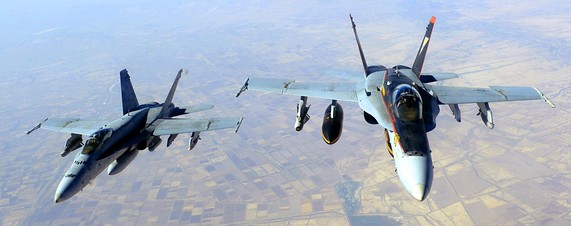
Mapping the airstrikes served several functions, ranging from putting the unknown Khorasan Group on the map to lending legitimacy to incursions into Syrian airspace, without Congressional approval or UN support. Indeed, the flatly declarative map advanced arguments about the just nature of the war against the “Khorasan Group” by American forces, even if few had heard of the Group only days before. With the crude map, the presence of sites of danger suddenly assumed concrete locations and had already been vanquished: eight “Khorasan sites” according to anonymous sources, were hit by Tomahawk Cruise Missiles launched from ships or submarines in the nearby Red Sea and F-22 Raptor stealth aircraft and Predator or Reaper drones, as if those same sites of training camps where alleged threats against the Homeland were being planned did not lie in Syrian territory or the attacks against them did not violate Syrian airspace. Rear Admiral Kirby, the Department of Defense spokesperson, bluntly summarized the results of the airstrikes with the satisfied resolve of self-justification: “We certainly believe that we hit what we were aiming at.”
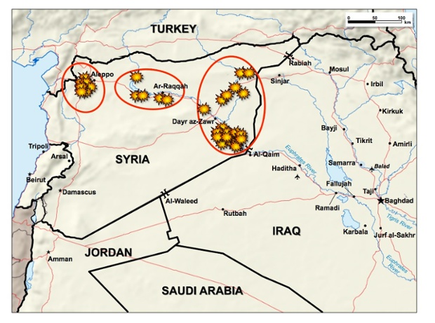
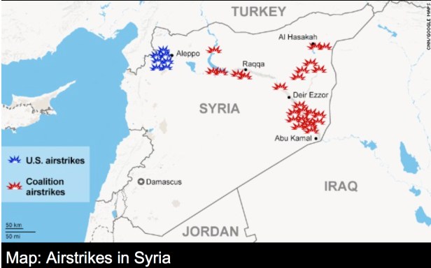
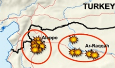
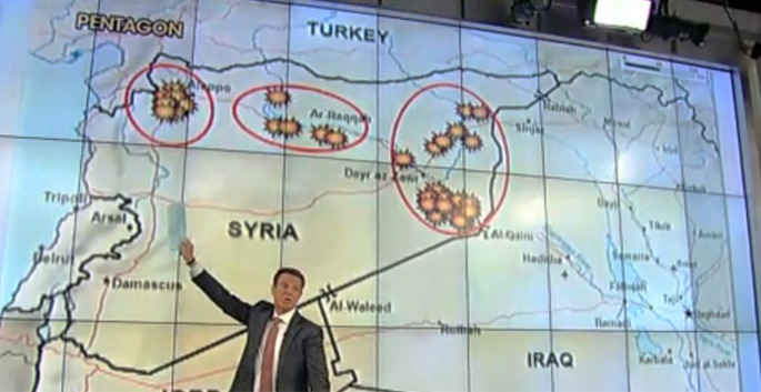
The map before which he spoke at the DoD news conference suggests more targets, but show eight yellow bursts west of the embattled city of Aleppo, where the Khorasan Group is said to be based, close to the border with Turkey. The strikingly cartoonish map signs that designate targets of airstrikes are akin to explosive bursts as if taken from an outdated video game that suddenly seem the centers of attention in an opaque landscape, which is so different from the recent maps we have seen of an expanding Islamic State–the alleged focus of earlier airstrikes across the region. And rather than display the movement of arriving airstrikes, moreover, the explosions ringed with orange suggest an ability to attack across the country.
 .
.
Such situation maps immediately circulated on the nightly news and online alike, in a remarkable instance of a single map that has been adopted wholesale to explain and describe the airstrikes effectiveness against targets. Attorney General Holder’s odd obfuscations seemed desperate attempts to justify the bombing of select Syrian sites, and broader justifications that claimed the airstrikes were performed “out of concerns that they were getting close to” attacks. This affirms claims that the bombings were needed to stop “imminent” attacks on the “homeland” of the United States, in ways that evoked 9/11–although “imminent attack plotting” was newly qualified in Orwellian Newspeak when intelligence identified plans as “in an advanced stage,” albeit without known targets or actual attacks suspected or needing to be feared. (The discussion of these bombing strikes from planes and ships conspicuously did not include acknowledging possible civilian deaths or casualties–and neither did President Obama’s speech to the nation–as civilian casualties reported by the Syrian Observatory for Human Rights including at least 300.)
The signs designating hit targets, akin to dated video games, but seemed, placed on a map, to affirm the remove at which Pentagon mappers of the scene of battle, as if to designate the complete obliteration of a place without civilian casualties:
What were these targets they took out, and how immanent was their threat? The maps issued by the Department of Defense did the difficult work of parsing a national incursion aimed at cells lying within a country but is not part of it, in what seems a new triumph of the logic of a war on terror that knows no bounds. With “US-only strikes against the Khorasan group” sent into Syrian airspace beside an unspecified number of other international pilots to perform over 200 strikes on a dozen targets, they gave legitimacy to the “Khorasan Group”–evocative less of an insurance firm than an Afghan drug cartel traded on the deep web or Silk Road–as being worthy for attack that did not deviate from a mission ostensibly directed against the expansion of the Islamic State. Indeed, while the territory that the Islamic State controlled have been so often mapped and re-mapped in recent weeks, the Khorasan Group has suddenly emerged, territory-less, just around September 20, three days before the airstrikes, as “the cell in Syria that may be the most intent on hitting the United States or its installations overseas with a terror attack.” The maps elevated targets of alleged imminent danger at the same time as apparently wiping them out.
The map persuaded public viewers that our bombing campaign was indeed justified, against the specter of a careful construction of the danger of an immanent “homeland” attack. The designation of the Khorasan Group was explicit, effective and swift. Martin Dempsey, Joint Chiefs Chairman, described “imminent attack plotting” as if to compensate for the acknowledgement that, for all its horrors, ISIS did not in itself pose a threat to the United States; Chairman of the Joint Chiefs of Staff William Mayville, a public face for the army, described “The Khorasan group [as] in the final stages of plans to carry out attacks against Western targets and potentially against the US homeland,” although he was loathe to say the effects of strikes definitively degraded or deterred imminent threats to the “West and the homeland.” The implicit narrative, of course, was of an attack forestalled, and, this time, the eradication of conspirators poised to attempt to hijack another airplane destined for the United States. The existence of such a super-national entity raised some eyebrows in Syria, as well as in the US-based press; Glenn Greenwald wryly noted how government leaks “after spending weeks promoting ISIS as Worse Than Al Qaeda™, . . . unveiled a never-before-heard-of group that was Worse Than ISIS™.”
The maps issued by the Department of Defense jumped several steps in logic in order to advance this argument, skipping over questions of international law or powers to declare war. “Imminent” is a key word by argued the attacks made without Congressional consultation were justified. They almost represented an interesting illustration of the evolving nature of President Obama’s thoughts on Presidential prerogative. For the situation map legitimized the prerogative to invade a nation’s sovereign boundaries without Congressional oversight. If Senator Obama had forcefully argued in 2007 “The President does not have power under the Constitution to unilaterally authorize a military attack in a situation that does not involve stopping an actual or imminent threat to the nation,” holding “military action most successful when it is authorized and supported by the legislative branch,” decisive weight fell on the formulation “imminent threat.” United States Deputy National Security Advisor Ben Rhodes described the Khorasan Group as holding “very clear and concrete ambitions to launch external operations against the United States or Europe” in ways that justified their inclusion in an already loosely justified attacks on the Islamic State–even if the strikes were clearly removed from the areas under IS control in maps as the below, as if in the hope that this detail would not be noticed.
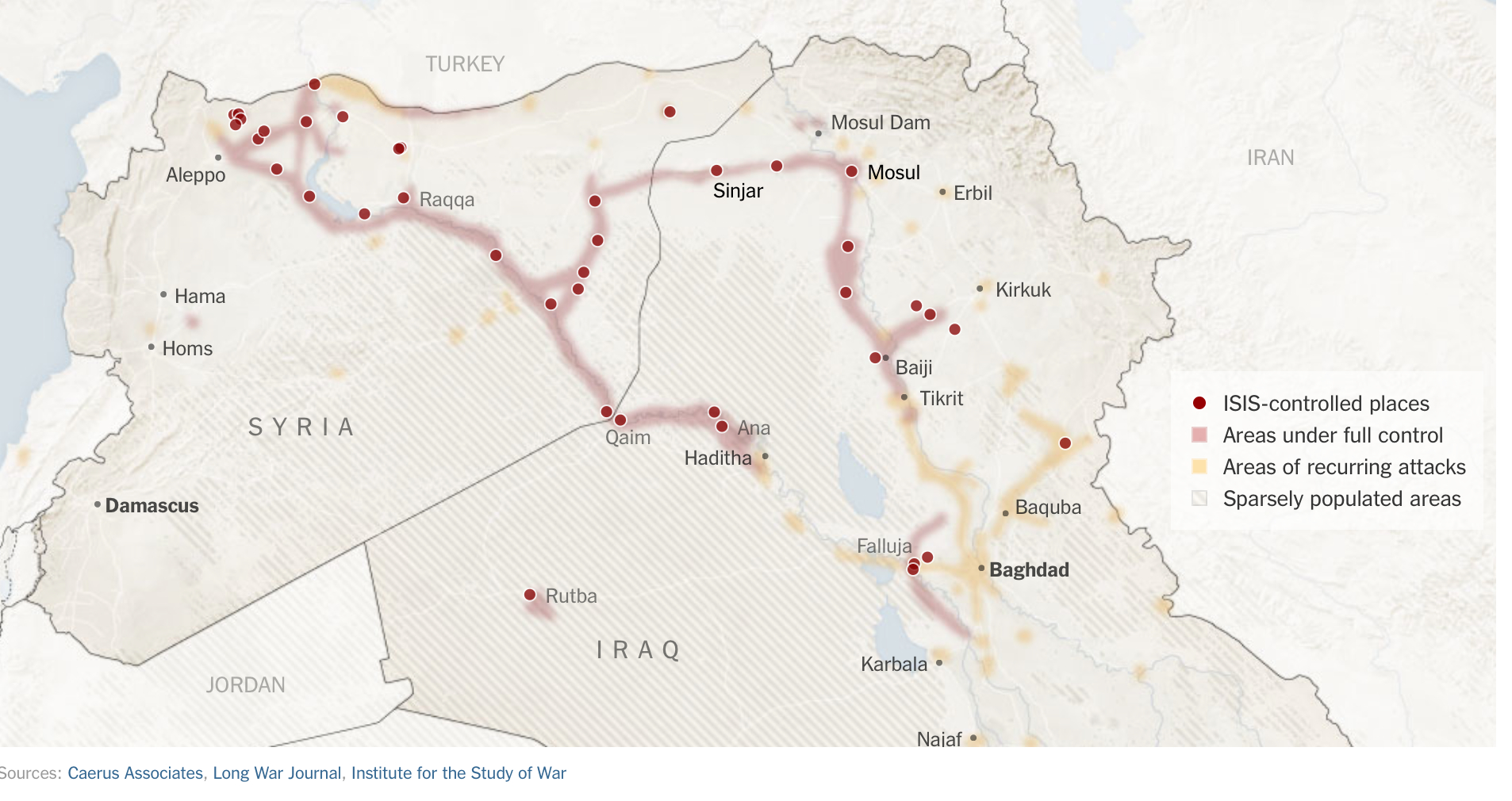
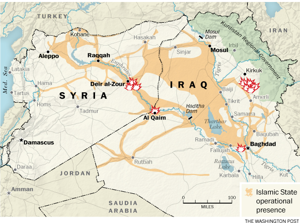
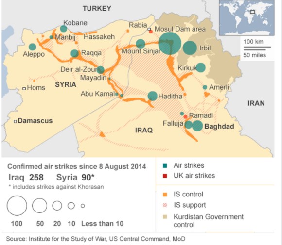
The singling out of this region of attack is a clear expansion from maps of earlier airstrikes that were diffused by Central Command, where bomb-bursts correlated closely with strategic points held by the Islamic State, as if to demonstrate the effectiveness of the response that the United States was asked to contribute in Iraq:
The strikes seem planned with the intent to show the ability of the American air force to strike targets in western Syria, even should Turkey not grant them permission to use a nearby air base, as well as to generate a confidence in the US government’s vigilance against terrorist threats. This alternate configuration of the airstrike map did interesting work by isolating the Khorasan Group as something of a separate entity from other Syrian rebels, worthy of intense attention from American air force. Although the identity of the Khorasan “Group” was much less clear to most Syrians on the ground, including members of the US-backed Syrian Free Army, among whom some eyebrows were quickly raised about the expansion of the attack; Charles Lister quite damningly questioned the proper nouns as a “label created by officials in the US and has no recognition within Jahbat al-Nusra or al Qaeda circles.” Indeed, a US official even set the size of the alleged cell as but a few dozen.
The relation of Khorasan Group to the Al-Nusra Front was important for the US to solidify, given that the last folks we should to attack are those aiming to topple Assad. But the two groups overlap in the eyes of Syrians who watched them at first hand–and speculated as to their danger. Indeed, since the Al-Nusra Front is dedicated to toppling Assad’s bloody dictatorship in Syria, the attack seems to have deemed important as a means to “take out” an international player in Syria–rather than interfere with Syria’s ongoing civil war. In a majestic bit of Orientalist rhetoric, among the “hardened al Qaeda members” killed in the airstrikes was the leader of the al Qaeda-linked Nusra Front, Abu Yousef al-Turki, “also known as ‘The Turk.”’
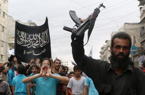
The Khorasan Group were identified as the targets of exclusively US airstrikes indeed do seem to have their own black flag–distinct from that of Jabat al Nusra–that jibe with the evocative hadith from which the name of this “Group” seems to derive: “If you see the black banners coming from Khorasan, join that army, even if you have to crawl over ice; no power will be able to stop them. And they will finally reach Baitul Maqdis [Jerusalem], where they will erect their flags.”
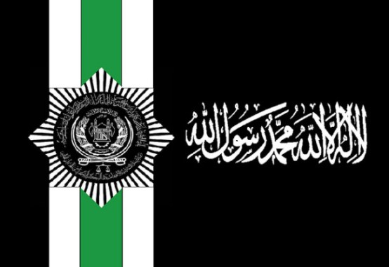
We were familiar with the terrifying mobilizing force of the closely similar flag of the Al-Nusra front, although it lacks scimitars as the Khorasan flag:
Although the Group may only number several dozen folks, the possibly organization was itself persuasively mapped to 9/11. The Khorasan Group™ were tied to a bomb-maker in Yemen, responsible for terrorist explosives that have been found on air flights, providing grounds for aims beyond the Syrian and Iraqi fronts–apparent validation of their association with Homeland threats to “U.S. aviation”–as if U.S. aviation has come to constitute a threat worthy of defense or surrogate for globalization. “Khorasan members come from Pakistan,” explained former CIA director Mike Morrell on televisions news programs, and “focus on attacks in the West” and even fixate on the aviation industry itself “as a symbol of the West.” The argument did not go over well in Syria, but played well in the Homeland, where many Khorasan members have been tied to to al Qaeda’s branch in Yemen, AQAP, including al Qaeda’s bomb-builder Ibrahim al-Asiri, of underwear bomber fame and to Musin al-Fadhli, an al-Qaeda insider who knew of plans for the 9/11 attacks, further justifying links to Homeland threats–rather than understanding their actual agendas in Syria.)
The logic of bombs fit closely into the rationale that lent the airstrikes legitimacy. President Obama explained the parallel ongoing strikes against areas occupied by ISIS, not themselves controlled by Assad, but his opponents, as giving Syrians a choice “in side of Syria other than between ISIL and Assad,” but found it justified to initiate the bombing without Congressional authority as Commander in Chief. The naming of a precise region in Syria bequeathed a more concrete logic for bombing by mapping a site that became a safe land for “a mix of hardened jihadi from Afghanistan, Yemen, Syria and Europe,” according to unnamed US officials, which by this past September 13 was identified as posing a greater danger to the US than ISIS itself–the original target of attacks, undertaken at the alleged request of an Iraqi state in need of defense from internal dangers.
The story led to a rather rehearsed an improvised re-mapping of terror threats–and seems to have followed a search for how one could possible pinpoint a direct threat to the United States in an area of the Middle East where the Islamic State existed, which could be said to pose concrete threats to American well-being and be seen as lying within the broad rubric “national security” rather than military aggression. The “cell in Syria” that was “little-known but well-resourced” could pose a direct threat to the US, the Pentagon explained, possessed “training camps, an explosives and munitions production facility, a communications building and command and control facilities.” Televised graphics suggested the vigilance of F-22 Raptor stealth aircraft overlaying Syria, targeting presumed national enemies:
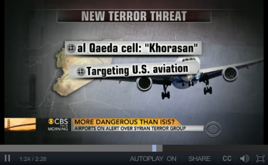
The apparent widespread newsleaks that led to clear hyping created a new sense of who we were targeting and why, providing a basis for attacks that did not need Congressional approval, or require more evidence aside from “aspirational” terrorism. Reporter Ken Dilanian offered the somewhat more “nuanced” take FBI director James Comey offered that “the U.S. did not have precise intelligence about where or when the cell, known as the Khorasan Group, would attempt to strike a Western target,” but that Syria is “a place where we don’t have complete visibility.” Director Comey offered that the FBI and US government was working with intelligence of “the kind of threat you have to operate under the assumption that it is tomorrow;” in the words of Pentagon spokesperson Kirby, “I don’t think we need to throw up a dossier here to prove that these are bad dudes [italics added].” Comey backtracked a bit from the “imminent danger” that the bad dudes posed, even as the battle drum had begun. “I don’t know exactly what that word means,” Comey added when questioned about the dangers’ identified as “imminent,” Dilanian notes quite amazingly. The group was identified in the media as able to “launch more-coordinated and larger attacks on the West in the style of the 9/11 attacks from 2001,” although by mid-September, or days previous [i.e., earlier] to the strikes, no official pronouncements had yet been made about the Group known as “Khorasan.”
The quite nondescript map of airstrikes unveiled and glossed at the DoD news conference does considerable work to tell a single story about the range of airstrikes US planes made with regional “allies” primarily concerned to communicate the danger Islamicists posed their own states. The map suggested an intensity of concerted actions, as if all of the airstrikes were directed against a common or single enemy, despite their distinctly separate targets of attack:
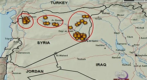
The eight strikes convey an odd sense of attacking an uninhabited borderland, which is also the very region where many Syrian refugees have passed on the way to crossing Turkish border:
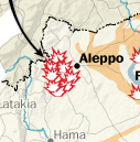
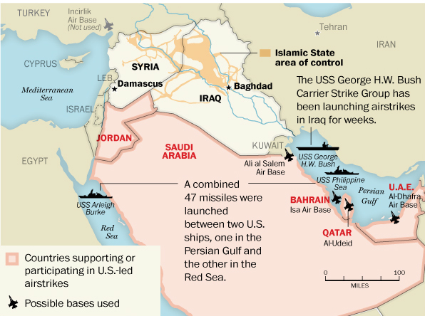
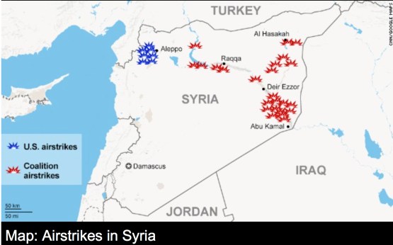
Who are these new folks who our are enemies? For Thomas Joscelyn, whose The Long War Journal has described the extended war in Iraq and Afghanistan, Khorasan consists of members of “core Al Qaeda” dispatched to Syria by Ayman al Zawahiri, and are embedded in the Al-Nusra Front, but the references of “seasoned al Qaeda operatives in Syria,” provides a new nomenclature of evil by which the US can, as CNN put it, “take the fight to the terrorists” hiding in “safe havens” west of Aleppo which, as Samantha Power put it as if to offer a validation for the ongoing attacks, “The Syrian regime has shown that it cannot and will not confront . . . effectively itself.” The US-only airstrikes–in which “coalition members” as Jordan, Saudi Arabia, Bahrain, the UAE and Qatar, each eager to address Islamicist threats endangering their own states, were absent–constituted something of the chief area that the US government seems to have wanted Americans to watch. But the low quality of the DoD map–and absence from it of a layover showing the Islamic State’s regional presence, or terrain–evokes a Google Maps base-map and image, designed less for informational value than to illustrate the clustering of American airpower west of Aleppo–outside regions held by the Islamic State.
The ill-defined maps on most new services were strikingly opaque and stripped of local detail, especially for showing such a frequently mapped area of strategic importance to the world. For they elicited minimal interest in the area or region where the airstrikes occurred, almost disembodied from thickly traced lines marking a sense of territoriality which most folks who have been following the news realize are increasingly of questionable value as points of actual reference or political orientation, but are presumably on the rather minimal base-maps afforded by Google Maps.

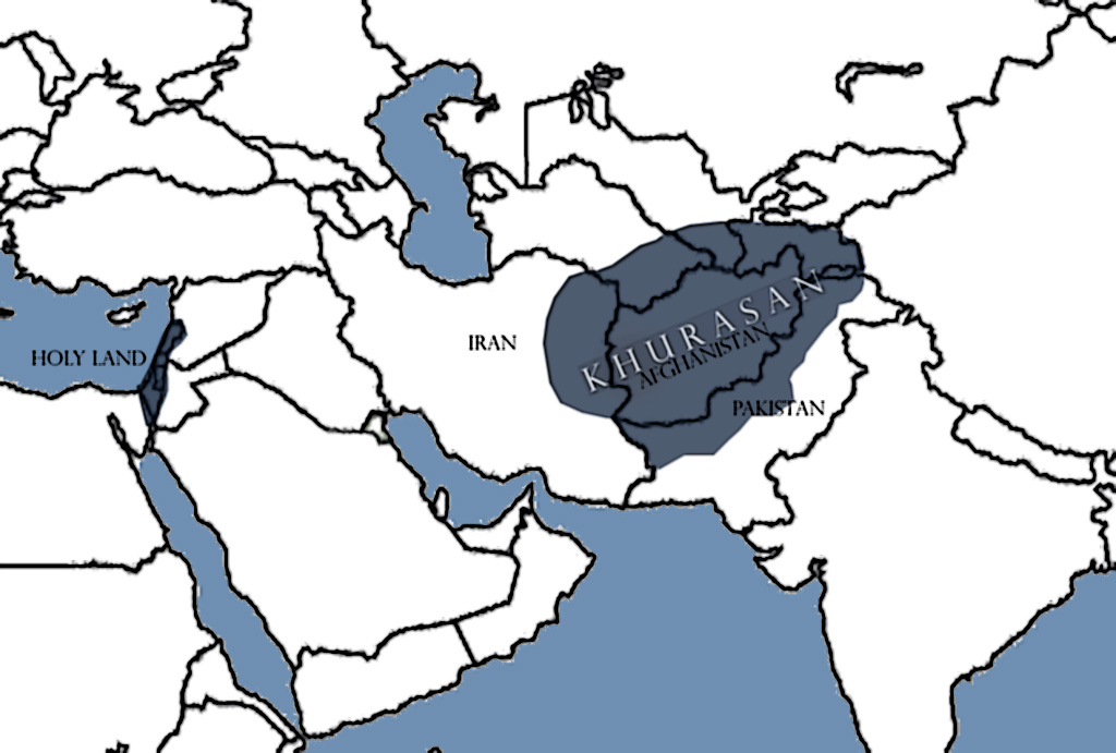
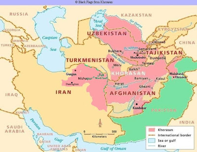
The concreteness implied by the use of this new proper name for a seemingly small group of individuals evokes a land “of the rising sun,” oddly quite similar to the Levant, but invested with tones of violence by the hadith of classical Islamic teachings that describes an army worth joining “even if you have to crawl over ice.” The pre-Islamic area of Khorasan from the 5th century A.D. till the second half of the 19th century A.D. is no real help–but seems to bring us back to Afghanistan and the AfPak problem of old. Despite much of the skepticism about how a group “suddenly went from anonymity to the ‘imminent threat’ that became the [compelling] rationale for a emergency air war” coming from the right, who mockingly distinguished “core al-Qaeda” from “al-Qaeda in Iraq” or the “Islamic State” that was formerly “al Qaeda in Iraq and al-Sham,” itself unlike “al-Qaeda in the Islamic Maghreb,” charging Obama with a strategy of “miniaturizing” a problem rooted in the reading of Islamic scriptures that drives Sharia suprematism and the deception perpetrated by a misguidedly Islamophilic President, according to former terrorism federal prosecutor Andrew McCarthy in the National Review; Glenn Greenwald and Murtaza Hussain offer a parallel critique of how news feeds from Washington have incrementally but steadily perpetuated the myth of a deadly Khorasan splinter aimed at attacking America through hijacked planes, feeding legal justification for bombing Syria to a national press ready to recycle with appropriate graphics for broadcast on Nightly News.
The attacks did not hit the “Khorasan Group” seem rather transparently about a form of “degrading” that had little to do with the organization of the Islamic State. Multiple news graphics on nightly television focussed on targeting of makeshift oil refineries that have financed the Islamic State’s revenues upwards of $3 million/day from oil smuggled out from eleven fields under their control–refineries that our “partners” were eager to help destroy–as if this somehow lessened the danger of collateral damages of airstrikes by legitimizing their targets. Yet despite the preemption of an ability to “degrade” what is now the richest terrorist organization in the world, existing investment in institutions and bureaucracies that uphold and strengthen Sharia law and governance and an efficient financial network will simply not be able to be destroyed through use of airstrikes alone.
 Associated Press Interactive
A collapsed map of the extent of “allied” airstrikes over the region tragically reveals, however, the intensity with which the area has continued to be pounded from the skies by manned or unmanned flights already for a series of months, in what can almost be mapped as an extended war of nerves.
The Department of Defence situation maps that described the bombing of the Khorasan Group west of Aleppo served, in reference to a mythic land or region, to embody the enemy in a new way, giving them a redolent name–even if one not actually apparent on the several situation maps so conspicuously displayed, by evoking a group which once constituted a region, or territory, until the late nineteenth century ruled by the “Khorasan” Kings. Although the term that jihadists used to refer to folks from that area in the world–described by the West as “embedded” in the Al-Nusra Front–suggests a recycling of the toponym perhaps helps suggest a site of mythic struggle for US airplanes to attack, as if to deflect the question that we are not attacking Syria’s sovereign lands without Congressional authorization, if only since the Group seemed to arrive from a different territory.

The Khorosan region perhaps gains its very nefariousness since it is not a state, but its statelessness manages to overlap with a region of danger, but itself to possess even more terrifying but less recognizably coherent bounds than the Islamic State–and as if the association of the name with the region of Afghanistan communicated its credibility as a national threat. (The very fact that Jihadists are themselves widely known to refer to anyone who comes from the geographic area as “Khorasan” raises questions about the integrity or identity of an actual fully-fledged “Group.”)
The name inspires terror, indeed, as, while never used to name the interests of a purported Al-Qaeda cel, it is implicitly linked to the threat of redrawing the map of the Mideast in an imaginary optative geography in which the current group of US allies would no longer exist:
Few would be likely to consult early nineteenth-century printed maps to locate the Khorasan Group or follow the rapidly evolving news, but a simple search would have led to a region suspiciously near to Afghanistan, and not a disembodied “Group” that the Director of National Intelligence James Clapper suggested, when he warned on September 13 with administration sources of “veteran al-Qaeda fighters . . . who travelled to Syria to link up with the al-Qaeda affiliate there, the Nusra Front,” going so far as to admonish the public that “in terms of threat to the homeland, Khorasan may pose as much of a danger as the Islamic State.”
As the thinly informative airstrike maps made their circle on the news circuit, embodying the threat of the Khorasan Group as if it had migrated from Central Asia to west of Aleppo, instead of lying in Syrian “safe-havens,” that constituted a “serious threat to our peace and security” as if they offered grounds that the airstrikes constituted a means “to defend our country.” The striking thin-ness of the map of airstrikes contrast to even the far greater local detail with which Khorasan was embodied as a region in this 1881 map “Khorasan and Neighboring Countries,” whose topography was delineated with lavish local detail by Lieut. Colonel C.E. Stewart: if Stewart attempted to concretely render the region, the danger of the “Group” lies in its ability to move, hidden, under the radar as it accomplishes underground and illegal acts of terror both outside and against the recognized group of nations.
 Wikipedia
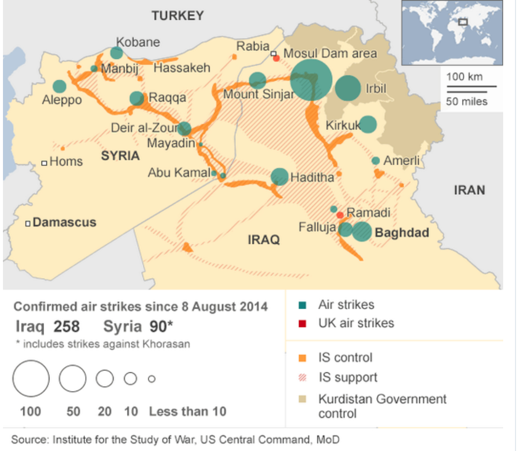
Rather than map the lay of the land or encourage interest in its inhabitants, the maps used in news conferences and that migrated to news shows are dense graphics that limit their content to the view from the Pentagon. It bears remembering that the stories that our current strategic maps tell are far more limited, and seem designed to display far less curiosity about who are the inhabitants of these lands; they go so far as to embody them far less concretely, displaying the overlays of boundary lines between nation-states in thick black lines, as if to create the somewhat outdated illusion that sovereign states of Syria and Iraq still exist in what seems a staging area for war. The maps situate the location of the strikes against the Khorasan Group–which somehow seems improbably hit without civilian casualties–in the far left cluster of explosions sent by American planes based in the Persian Gulf and Red Sea, using symbols that recall the medium of an old arcade video game so clearly that one is tempted to take the thin view of history they offer as their message–in a radically flattened view of the complexity of ongoing conflicts between Syrian opposition, ISIS, Iraqi troops, and Islamist movements. What, the message of the graphic seems, else do we need to know?

Where they are located perhaps seems less the point anyway, since they have been “taken out.”
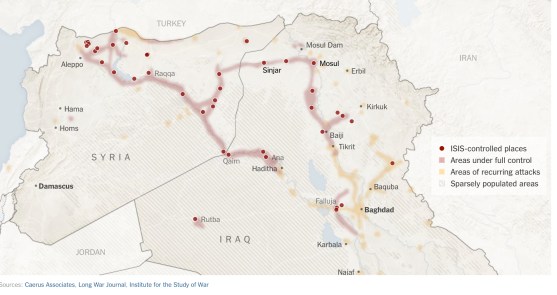
What seems less widely mapped is the extent to which the folks we are attacking are already surrounded, and we sought to display how even an area near the Turkish border–where the United States has an Air Force Base, but from which the Turkish government would not allow United States planes to fly or missiles launched into Syria–but also lying at much remove from what we have mapped as the expanse controlled by the Islamic State as of September 23, 2104. It allowed us to defend American interests at the same time as we continued to “degrade” the Islamic State from military bases that lie to the South, as both “allies” like Kuwait, Saudi Arabia, Qatar and Jordan allowed their airspace to be used, at significant cost.
 Washington Post, September 23 2014
 U.S. Defense Department; Institute for the Study of War; September 23
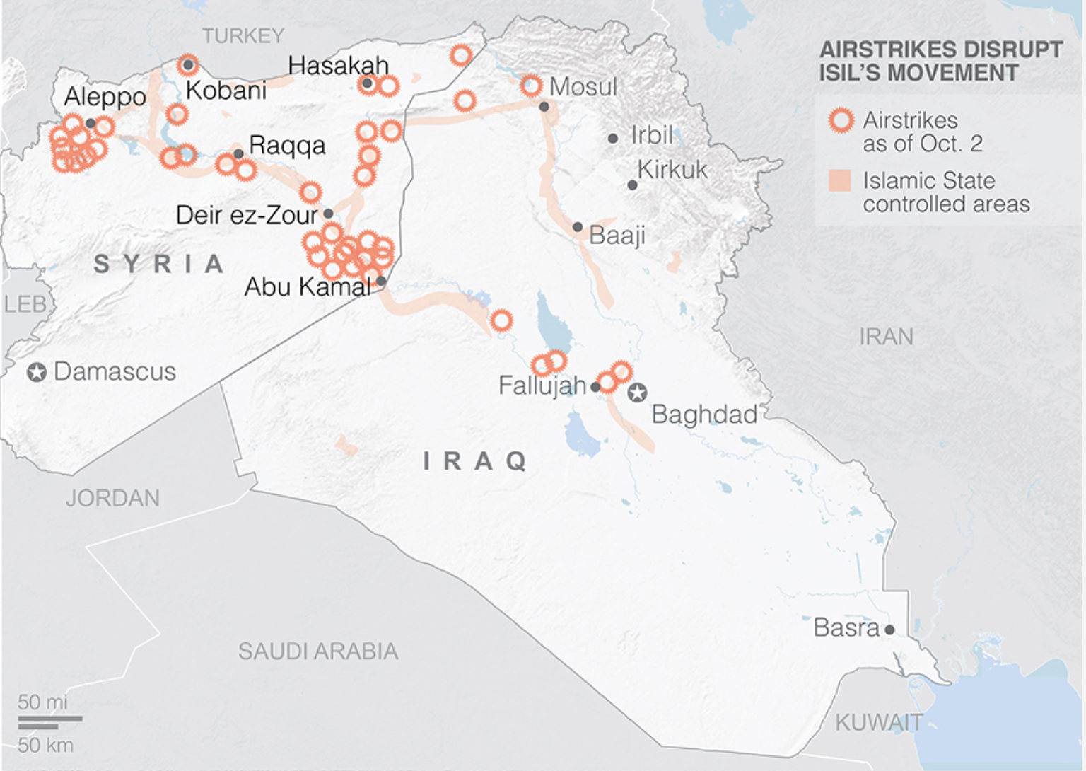
 AP Interactive; October 2
 Agence France-Presse/Getty Images
The extreme short-term benefits the Department of Defense claimed for the airstrikes –allegedly stopping planned attacks on the United States–may have unplanned consequence of creating deeper ties between the rebels, Islamic State and Al Qaeda, and cast the US as a protector of Assad.
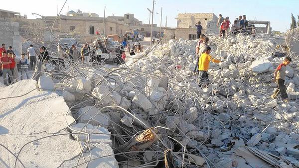
Syrian reactions to airstrikes have not been mapped sufficiently or in detail. But unannounced strikes extending beyond attacks on ISIS both raised suspicions about US priorities and intents and suggested an unwarranted deflection of attacking the Islamic State among groups who long hoped that the very same airstrikes would be launched at Assad’s forces, and not at an organization not known to Syrians, who deemed it a creation of the US government and false screen for giving cover to Assad’s government troops to advance. With houses destroyed, numbers of refugees increasing, and women and children injured in targeted marketplaces in Aleppo, according to the Syrian Observatory for Human Rights, local desperation has grown in direct reaction to foreign interference. Despite claims the US has a comprehensive strategy to defeat the Islamic State, the attacks seem short-sighted in encouraging the very conditions to encourage the spread of extremism, local instability, distrust, and the isolation of local forces, both breeding insecurity and hurting a crumbling infrastructure. The reclusive leader of the Al-Nusra Front, Abu Mohammed Jolani, previously presumed dead, foretold the eruption of a “volcano” against the US and its allies would be the consequence of the attacks, and argued that the airstrikes were leaving Aleppo vulnerable to government forces. “Short-termism” sadly afflicts the strikes whose results extend far beyond the assassination of Al-Nusra frton leader Abu Yousef al-Turki. Meanwhile, ISIS advanced within shooting range of Baghdad.
The spread of protests across the country against US-led airstrikes raise questions about what their long-term strategic value really was, aside from leading many to question whether western help would ever arrive. (Questions about the precise accomplishments of the strikes seem deflected by Pentagon spokesmen.) Protests against the airstrikes are poorly mapped, but seem to have grown from Islamic State strongholds like Raqqa to cities held by the rebel alliance in Idlib province, as Maaret el Numan, or centers of the Free Syrian Army like Talbiseh, near Lebanon, as well as some forty other towns including Homs and Aleppo–some bearing signs such as “The International Alliance Kills Civilians.”
 Reuters
For the strikes indeed confirmed deep suspicions that official US policy is less concerned with ending Assad’s dictatorship, lent credence both by the public statements from Assad’s foreign minister that the Assad regime was “OK” with such airstrikes, which implied a collusion between Americans and the Assad regime; the occurrence of the first airstrikes to enter Syrian territory without any coordination with rebel groups to whom they might have offered strategic value seems to have sidestepped any support from the Syrian Free Army or its allies. For Americans find themselves in the intensely awkward position of relying on the OK of the Assad regime to “downgrade” or attack ISIS in Syria. The strikes seemed to realize fears and distrust about whose interests the United States wants to serve: Rami abdul Rahman, head of the Syrian Observatory for Human Rights alleges that the airstrikes illustrate the start of “a phase of targeting civilians under the excuse of targeting the Islamic State.” In a region where the claim “We kiss the hand that holds the trigger against Assad” is common, it is hard to know how bombings undertaken with the Assad regime’s OK would be seen as constructive. The bombings may have provoked a rise in Syrians declaring allegiance to the Islamic State.
 Idlib News Network: Syrians examining the ruins of a house allegedly targeted by airstrikes in Kfar Derian, a center for Nusra Front opposition
We might remember that most all maps posted above derived from a map that really was carefully staged as a screen, which obscured far more that it revealed.


 Thomas Van Linge/Newsweek/@arabthomness
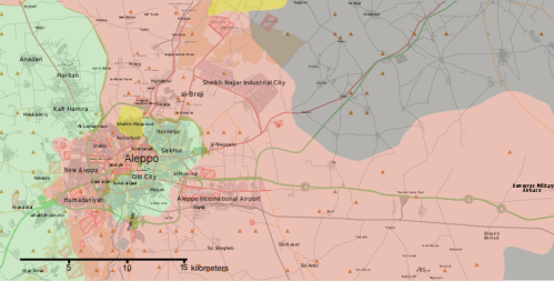 November 1, 2016/
 Thaer Mohammed/AFP/Getty Images
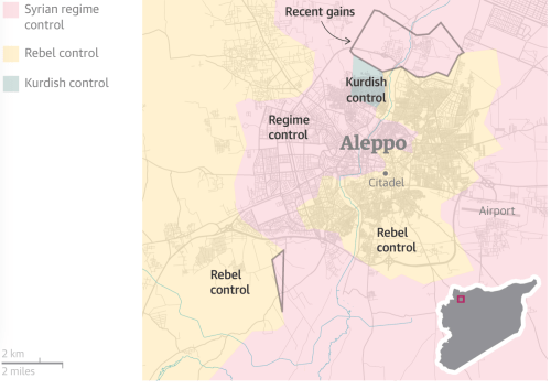
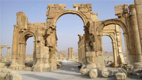
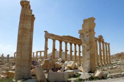 Maher Al Mounes/Agence France-Presse/Getty Images, March 27, 2016