Commemorating Christopher Columbus’ transatlantic voyages in a “discourse of discovery” has been magnified as they have become a bit of an exercise of collective remembering and of world-making. For Columbus monuments are less markers of fifteenth century voyages, than they serve to frame a range of narratives of discovery that promote the fifteenth-century navigator as an icon of nationhood that were foreign to the fifteenth century. In making claims for the foundational role that the navigator’s transatlantic voyage, they create a new narrative of nation, particularly powerful for its ability to occlude and obscure other narratives, and indeed the presence of local inhabitants in a region, so that they assume the deracinating violence of a map: as claims of possession, and indeed mastery over space, they dislodge nativist presence in a region, much as Columbus did as a royal agent, glorifyinf the acts of renaming, and taking possession of, the new world to ally the viewers with the heroism of the Genoese navigator’s foundational act of taking possession of the New World. The heroics posture of Columbus, until the recent spate of decapitated statues revealed a long simmering anger at the canonization of this figure as a founder of the nation, suggested a model of a white America, an erasure of indigenous inhabitation, and an outrageous lie.
Columbus set the basis for such grandiose claims, perhaps, by staking the transatlantic “colony” La Navidad as the first settlement by Europeans of the New World on Christmas. The event’s commemoration has continued in statuary across the Americas, even if the thirty-nine settlers left behind in the settlement were all massacred by natives after their ship, the Santa Maria, was dismantled after it hit a sandbar, and the men of the lost caravel that ran ashore on a sandbar off the island Columbus had auspiciously renamed Hispaniola, as evidence of Hispanic claims to sovereignty for his patrons, its hull and crossbeams converted to a fortress that was later burned to the ground. While the crew left with a translator who were instructed to collect a store of New World gold as they awaited his return may have been overzealous in courting natives that they were all killed, the extraction of riches and wealth and slaves motivated the New World settlement.
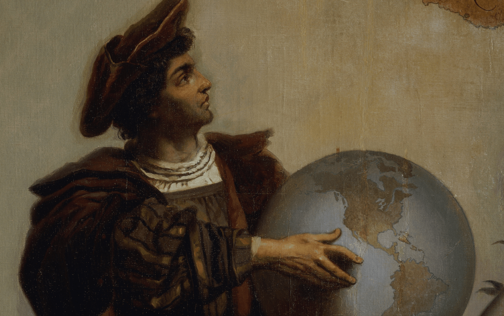
Yet in the commemoration of Columbus Day, the landfall has been renarrated as an inspired revelation of new lands, and allied with a sense of manifest destiny in retrospect, foregrounding the imperial mission of laying claims to new lands under the eyes of God. Yet the elevation of Columbus as a figure of state, and a westward course of empire, was magnified only in the nineteenth century. Paradigmatically, the painting of Columbus taking stock of his arrival by Dióscoro Teófilo Puebla Tolín, staged before uncomprehending natives cowering offstage, occurs as a missionary raises a cross on verdant shores where sailors triumphantly raised recognizable standards of the Spanish sovereign in the New World.

First landing of Columbus on the shores of the New World, at San Salvador, W.I., Oct. 12th 1492,
re-rendered by Currier and Ives, 1892/Library of Congress
The bucolic image of arrival was cast as a triumph of technology, civilization, and deliverance. The bucolic scene not only denied violence, but was an image of paradisal promise that Dióscoro Teófilo Puebla Tolín rendered in a manner widely reprinted in the lithograph of the commemorations of quadricentennial celebrations of 1892 as a narrative of westward expansion of Manifest Destiny. The recent re-questioning of Columbian commemoration as a common national identity led to the questioning of commemorative Columbian statuary across the United States, from Columbus, Ohio to San Francisco to Kenosha, WI, to Miami. As the statues were dislodged from the common memories of an Italian-American community–as many once were in New Haven, Boston, and Philadelphia as well as New York City–their place loosened in a narrative of nation in ways that needs to be told. This was a narrative quite unlike how Michel de Montaigne bemoaned the manner Iberian voyages as occasions of devastation,and extraction had so needlessly left so “many goodly cities ransacked and razed; so many nations destroyed and made desolate; so infinite millions of harmless people of all sexes, races, states, and ages, massacred, ravaged, and put to the sword; the richest, the fairest, and the best part o the world topsy-turvied, and defaced for the traffic of perils and pepper.” Montaigne’s deep discomfort wit the global catastrophe that was driven by greed cerated an economic and epidemiological devastation in their wake were substituted by a massive hulking bronze Columbus, standing as if a champion of Christianity that would be a gift from Moscow’s mayor to the “free world.” Driven by increased recognition of the truly genocidal destruction of indigenous in the moment of contact, the term “genocide”–long reserved for the Holocaust but increasingly applied to the destruction of indigenous peoples in Guatemala, Bolivia, and Argentina in Latin America–led to the recognition that Columbus’ unqualified heroism needed to be qualified.
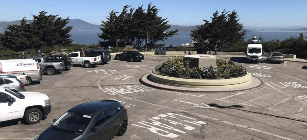
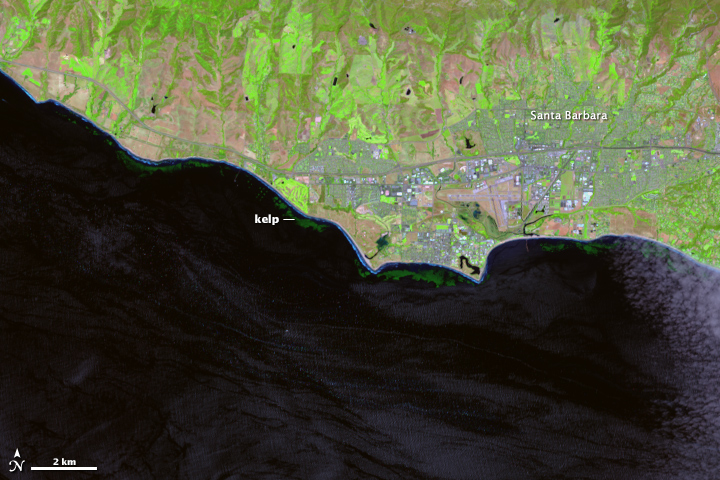
It was in this context that the monument of Columbus that Trump mediated as an erasure of the collective memory and of the past in the americas. The burst of creative iconoclastic energy directed to statues of Columbus left San Francisco’s City Arts Commission preemptively removing the monument to Columbus overlooking the Pacific from its monumental pedestal in order to maintain the local peace–a statue long defaced in recent years–before it was defaced. The recent removal of monuments to Columbus spread as a re-tallying of moral accounts, but a restoration of civic peace. The importance of refiguring the commemoration of colonization grew as a form of reparations whose logic was unmistakably national in character,–if the first questioning of Columbus Day had been local and selective in 1992-3.
The deposition of the 4,000 pound bronze statue of Columbus to a holding container channeled the rejection of the figure of Columbus whose monuments were already deposed in Boston, St. Paul, Minnesota; Camden, NJ; Richmond, VA, and other cities in New York state, one of which was beheaded–if long after the statue to the navigator was ceremoniously pushed into the ocean in 1986, in Port-au-Prince, Haiti, with a placard “Foreigners out of Haiti!” And by 2020, the ease with which statues of Christopher Columbus were assimilated to the confederate monuments preserved across many southern states–and preserved at considerable cost to American taxpayers–reminded us of how easily the memory of Columbus as colonizer was cultivated among white supremacists as iconic testaments to a sense of historical security of another era we were trying to pry ourselves free in hopes to gain distance on. Even if the statues of Columbus and Columbus commemorations are overshadowed by the razing of the statues of Confederate generals in recent years–


Confederate Monuments Removed since George Floyd’s Murder
–the images of the dicsoverer were dismantled as we engaged a contested legacy. If monuments removed with an eye to toppling racism across southern states that had commemorated secession in the attempt to defend enslavement and chattel slavery were a stain on the nation that emerged like a return of the repressed in the summer after George Floyd’s murder by overly zealous “law enforcement” forces, the removal of monuments had begun as undeniable evidence of their talismanic status as lodestones for white supremacy became clear after violence in Charlottesville directed attention to the degree to which commemoration of the Confederacy kept a memory alive in national and local consciousness, revealing how undecisive the Civil War was for the preservation of local memories across many border states or secessionist states, and the toxic nature of preserving memories of southern secession as a defense of what were cast as local liberties within the union.

The division assessment of historical legacies that shape a narrative that informs the present landscape of inequity had been contested for decades around the heroicization of the figure of Columbus as a shared national point of reference. As much as the seven hundred and eleven standing monuments of commemorating secession–over 1500 statues which are collectively preserved by taxpayers’ money at a cost of $40 million for annual upkeep. The standing statues dedicated to anti-abolitionist figures have kept the memory of the Confederacy alive across the United States, including of Jefferson Davis and Robert E. Lee in Virginia, Georgia, North Carolina, and Texas, creating a topography that has inflected political identities.
Donald Trump was savvy if hateful to tap this energy of amnesia, during his first Presidential campaign in 2016. He re-presented himself as an incubus already planting seeds across the land, many of which were only removed by energized (and disgusted) protestors or whose remove was ordered by city councils in an attempt to preserve the local peace–including of the unidentified heroic “Confederate soldier” who removes his hat in downtown Alexandria, VA, removed only in June 2020–if similar statues remain in Jacksonville FL, and San Antonio TX, heroizing as if sanctioning the very option of local resistance to according rights to enslaved populations, beyond preserving memories of war dead. The confederate statues were long mythologized as an alternative system of justice, echoing the reduction of rights and civil equality across the landscape by holding up a distorting mirror of Southern victory and secessionist pride, gaining legs as grounds to advocate an outdated status quo reflective and constitutive of an alternative order unto its own, as is evident in the naming of courts of law after Confederate names.


The spattering of blood on Columbus memorials call for a revision of public memory complicit in a culture of spatial colonization that perpetuates the fundamental nature of racial hierarchies. The requestioning of commemorating the act of violence as fundamental to the nation’s values is a questioning of their place in civil society, and their meaning to the nation, motivated in no small part by the ugliness with which they have been seized with new currency as images justifying a racial superiority and sanctioning the violence of enslavement along racial lines. For their removal had tried to call attention to the dangers of commemoration by targeting the figure of Christopher Columbus, whose statues had first multiplied across American land in roughly the same era of the later nineteenth century, following Confederate statues, in a sort of monument trick that served to naturalize white possession of indigenous lands.
The overturning of commemorative statues of the fifteenth-century navigator so deeply dissonant to our sense of national belonging, common memories, redressed disturbingly long-lasting spatialities–the average statue was almost a hundred years old–as the nation entered a temporal loop of recursive nature of reparative bent, as the destiny Columbus imagined for himself as a civilizer and discoverer of a New World–and new continent–emerged in increasingly pressing ways, opening up the very speech act of taking possession of the Americas as a fiction, only masquerading for utilitarian ends as a binding legal precedent. For only by confronting the painfully exclusionary nature of such an act of taking possession, deriving more from the practices of enslavement and mastery of others that run against the very basis of our own civil society, or the civil society we seek to create.
Indeed, the San Francisco’s 4,000 pound commemorative statue of Columbus, often defaced as a symbol of enslavement and subjugation in recent years, was removed by a crane and as a call to dump it into the Bay was circulating, on Thursday, June 18, removing it from a scenic site by the Pacific beside Coit Tower, leaving an empty pedestal, perhaps to reduce the need to clean up a statue that had been repeatedly defaced in recent weeks but also to show consensus about lack of interest in defending a symbol of oppression, enslavement, and colonial violence, and public outbreaks around the call to depose the statue off Pier 31, not as a symbol of colonial resistance, but an expunging of the navigator from national history. All of a sudden the dismantling of public memories of Columbus’ heroism were national news, a divisive issue responded to not with understanding but professed shock for besmirching American history, not reassessment of values, battling Italian-Americans Nancy Pelosi herself as forsaking, as if to bemoan her betrayal of the preservation of the hallowed memory of Christopher Columbus in the summer of 2020 to stoke lines of political division in the heat of the 2020 Presidential campaign: the fate of the statuary of Columbus was a bell whistle for stoking fears of a danger to the status quo.
It was as if the spontaneous prominence across the nation of memorials to George Floyd, proliferating on street walls in full color, and in haunting offset likenesses, provoked introspection demanded introspection of what sort of memorials we identified with and wanted to see the nation, placing on the front burner of all the question of commemoration in terms that had long been glossed over and tacitly accepted. The questioning of commemoration after Floyd’s murder came to articulate a spontaneous rebuke of the continued validation of racialized policing and police violence, throwing into relief discriminatory monuments. There were soon few defenders of the monument able to tolerate how they emblematized division of the social order, eager to ask us to situate Columbus more broadly rather than historicize his complicity in “some of his acts, which nobody would support,” without addressing the framing of the logic of “discovery'” in imperial narratives of conquest and disenfranchisement of indigenous claims to sovereignty and to recognize the need for reparations.
For the navigator embodied an imperial relation to space and terrestrial expanse, discounting the inhabitants of regions, and affirming the abstract authority of sovereign claims and sovereign expanse, however improbably early maps placed the islands in the Caribbean–later called Hispaniola–based on his conviction that the Atlantic Ocean was able to be traversed, enabling transatlantic voyages for which Spain was well poised to expand commerce far beyond the coast of Africa and the Mediterranean for economic ends in an “Enterprise of the Indies” that Columbus proposed to John II of Portugal, before he set out to claim the new lands for Ferdinand and Isabella. The longstanding embedded nature of Columbus in a discourse of claiming land–a discourse from which he was not only inseparable, but embedded maps in claims of the administration and supervision of lands far removed from seats of terrestrial power, a map-trick that has been celebrated since as a form of inscribing territorial claims on a piece of paper or globe.
And if Columbus had no actual idea of the form of North America, the persuasiveness of fictive reimagining of his mastery over space–a mastery cast almost uniformly in intellectual terms, rather than in military terms of disenfranchisement or enslavement–provided a logic that is aestheticized in the monument as a mode for the possession and persuasion of possession over terrestrial space more akin to American hemispheric sovereignty in its open heroizing of a national geopolitics of the 1890s than to a Renaissance discourse of discovery–comparable to the reimagining of hemispheric sovereignty in the years after the 1867 withdrawal of Spanish sovereignty to Mexico.
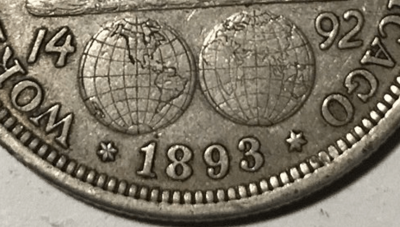
The origins of these reframing are perhaps obscure, but lionizing Columbus was always about rewriting the American narrative, and distancing one race of immigrants–the Italian migrant–from the very native inhabitants that the story of Columbus displaced. The navigator was promoted actively as a figure of national unity in the post-Civil War centenary of 1892, in which Columbus assumed new currency as a national figure, a map on silver able to enter broad circulation as a memory for how a three-masted caravel mastered terrestrial expanse, resting above a hemispheric map of global oceanic expanse. The anachronistic map suggests as much a modern triumph of hemispheric cartography–the coastline of the United States was surveyed by geodetic terms and that established the role of the United States Coast and Geodetic Survey in producing maps of uniform toponymy and hydrographic accuracy had only recently set standards of coastal surveying that unified triangulation, physical geodesy, leveling, and magnetic of authority within the US Navy to produce coastal maps of the nation extended from the Gulf of Mexico to the Alaskan shoreline.
The imperious gaze of the limp-haired navigator seems the first self-made man as he gazes with gruff determination on the coin’s face, almost entirely filing the surface of the first American coin bearing human likeness. Columbus was an icon it identified with how the hemispheric map took charge over a continent, and gave a sense of predestination to the recently settled question of continental integrity–and a territorial bounds that new no frontier up to Alaska, whose coast had been recently surveyed, and much of Florida and the Gulf of Mexico. Its design for the Chicago Word Exposition suggest a hemispheric dominance reflecting the growth of Rand McNally in Chicago, a map-publisher for America, as well as the self-assertion the United States as a hemispheric power, as much as the Genoese navigator about whom so many meanings have encrusted.

The striking hemispheric map of global navigability on the obverse of the coin circulated in Chicago’s World Exposition was global, but would also mimic the claims of hemispheric dominance that the hemispheric projection recalled, prefigured the Pan Am logo, in its global in reach–as if the image of a spherical projection devised by Rand McNally that spanned the globe and erased all borders might be cast as the seedbed for globalization was itself contained in the transatlantic voyages of the small trade ships, the Pinta, Niña and Santa Maria that were led with hopes of a profitable economic voyage with Columbus at the helm. (Rand McNally had not only sponsored the world’s fair, but its double spherical projection that recalled Columbus’ conviction of a spherical world by ahistorically featuring a cartographic design Columbus would have known; the planar projection was an icon of global expansion and conquest, more detailed in coverage than late seventeenth century double spherical projections.
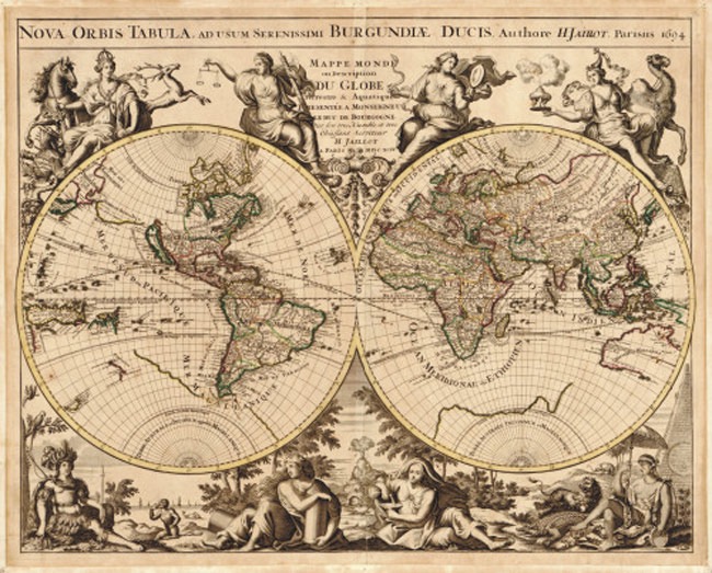
–but devised and issued its own elegant version of a world map based on the Mercator projection in following years from 1895, in atlases issued subsequent to the World’s Fair, to meet a growing market for global maps. Leaving much of the African interior unmapped, in a manner that cannot but recall Conrad’s Heart of Darkness, the image is a confirmation and announcement of global triumph, centered on the North American continent and United States, if it shows the world.