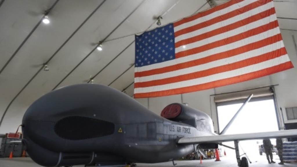
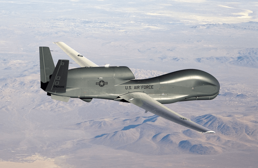
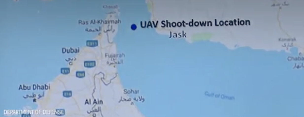
In a world where borders don’t often correspond landmarks or terrain, tensions of incursions on new forms of territoriality multiply. Tensions of violations of airspace and national waters pose questions of the accuracy reliance on mapping systems, moreover, difficult to contest or resolve on a single map, as, at the same time, the frictionless nature of drone flights–here embodied by the costly RQ-4A Global Hawk, whose price as a high-end unmanned surveillance tool reflects its abilities to transgress borders without detection, flying at over 20,000 feet across borders at a speed of five hundred miles per hour, embodies an ability to remap a space of surveillance by superior mapping technologies than other countries. With literally hours remaining before devastating military airstrikes on Iran, amidst fears that a slight miscalculation or misinterpretation of mapping systems could precipitate an unwanted war of massive scale, the strikes were canceled at 7:30 p.m. Washington time, and the threat that Iran had “made a very big mistake” de-escalated. Trump surprised the world by suddenly allowing for the margin of human error, even as he insisted the drone was flying “clearly over international waters,” rather than Iranian airspace just 750 miles southeast of Tehran, refusing to relinquish his own map of wherejn the Global Hawk was downed.
The trust in this unmanned drone may possess its own almost hubristic quality. For its downing by Iranian missiles downed not only a costly military surveillance tool, but punctured a space of surveillance of the Persian Gulf and Iranian territory, and a sense of security in a precarious geopolitical region–at the same time as the American government seems to be bent on increasing tensions about the continued flow of crude petrochemicals to much of the industrialized world, creating global flows and energy markets that are themselves concealed by the question of at what point Iranian missiles struck the drone–or into whose national airspace the drone was flying.
The downing of the drone punctured confidence in a continuous space of surveillance that was built, painstakingly and over time, to guard those global energy markets. While the shock to U.S. military intelligence may have been that Iran had gained the ability to observe, fire at and down the high-flying unmanned vehicles that they had purchased at considerable expense from Northrup Grumman, not revealed even by the most precise hexadecimal GPS coordinates, which would render the costly drones more than a poor investment in preparation for the very grounds of war that Northrup Grumman had promoted to transmit high-resolution images from higher than ever altitudes of sensitive hotspots in “real time.” The United States Military didn’t ever think Revolutionary Guards possessed or could acquire marked not only a threats of war,–and chose to celebrate the RQ-$ “Global Hawk” as a tool of maintaining an infrastructure of global surveillance rooted in Afghanistan, Iraq, and Syria, as well as covering the Persian Gulf, while piloted remotely, by yet another one of the increasing paradoxes of the globalism of globalization, by pilots in bases in Beal, California and Grand Forks, North Dakota, far from the military theaters they sought to control
But the shattering of this imagined space of global dominance occurred not in U.S. bases, or even on the military maps of Americans, but rather on the screens that Iranians used to monitor the unmanned vehicle’s flight, and, by extension, the missiles they launched that downed it. The missiles’ surprising accuracy disrupted the imagined continuity by which the United States hoped to extend sovereignty into international waters to protect traffic across the Strait of Hormuz–not only by a new surface-to-air missile, but a new radar system able to detect the drone–
–that effectively ended a map of surveillance that will no longer exist in the face of new Iranian defense systems allowing Revolutionary Guards to protect their territorial claims.
The Persian Gulf region has long been planned and imagined to be a new theater of possible war. Indeed, each side has become compelled to map the potential battle field in ways that has been forced the region to be remapped, creating a delicate balance of often contesting Exclusive Economic Zones, international waters, and territorial waters, in ways that have constrained the possibility of American surveillance. But the drone’s downing air revealed that Iranian guidance systems of surface-to-air missiles that Iran possesses to target drones, aircraft and unmanned vehicles are no longer clearly understood by the U.S. Army or U.S. military intelligence. The American “upper hand” in mapping technologies has perhaps been punctured, in ways that may cause the entire battlefield to need to be remapped in costly ways, if to preserve the delicate balance global trade of petroleum from the Persian Gulf, one of the most concentrated and easily accessible site of petroleum reservers, especially in the increased tensions between the United States and Iran.
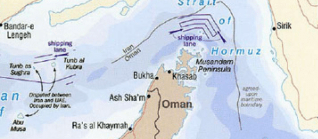
Airspace and territorial waters are more difficult to map on earlier maps, and difficult to map on top of shorelines, or in navigational routes, perhaps, for an untrained eye, but the proliferation of alternate readings of sovereign space have become especially fraught in the waters of the Strait of Hormuz, where overcrowded traffic turns on hairpin turns, seems to have been detected entering Iranian airspace–if one trusts the maps tweeted out in self-defense by Iran’s Foreign Minister Javad Zarif–who argued the unmanned surveillance drone had crossed the “red line” of its sovereign airspace without warning, ignoring alerts from Revolutionary Guards, and interpreted as threats to its sovereignty.
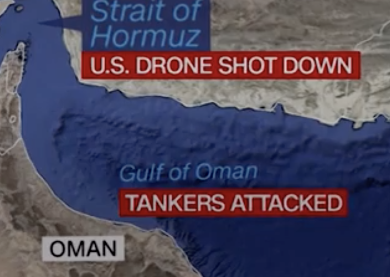
Coming on the heels of Iranian threats to shut the Strait of Hormuz to all traffic, as Iranian speedboats patrolled the waters, as if tempting to assert their control over the narrow passage-way out of belief that “if our oil does not go through the Strait, other countries’ will certainly not cross the Strait,” the jockeying for power over the transit of oil in international waters set up a conflict between where national sovereign interests began and ended, and what power the United States regained on a global geopolitical stage, even as the United States openly asserted the upper hand of global surveillance over what is one of the narrowest maritime site of petroleum transit in the world wildly out of proportion to the millions of barrels that cross the narrow strait daily, a transit that wildly dwarfs the petroleum carried to global markets by other maritime routes–despite the quite narrow nature of its passage, and the even narrower space of international waters by which oil tankers navigate the Strait.
Where the unmanned vehicle flying American colors flew–and whether it crossed into a sovereign space–bedcame a flash-point of regional tensions, so much that the downing of the $110M drone, long celebrated by the U.S. Army as covering surveillance needs over the Gulf, embarrassingly became a target of Iranian defenses, as it was downed on June 20, even as it was flying at over 60,000 feet, or above what American forces believed that Iranian Revolutionary Guards could detect. The illusion that American unmanned surveillance drone RQ-4A Global Hawk could itself move frictionlessly across national boundaries without being downed was itself unmanned, creating a small catastrophe or large disruption in the international balance of powers.
Did it cross the red line?
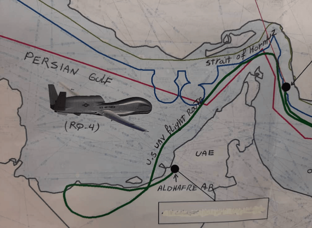
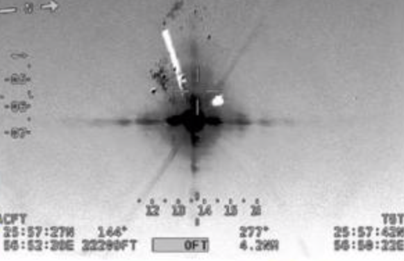
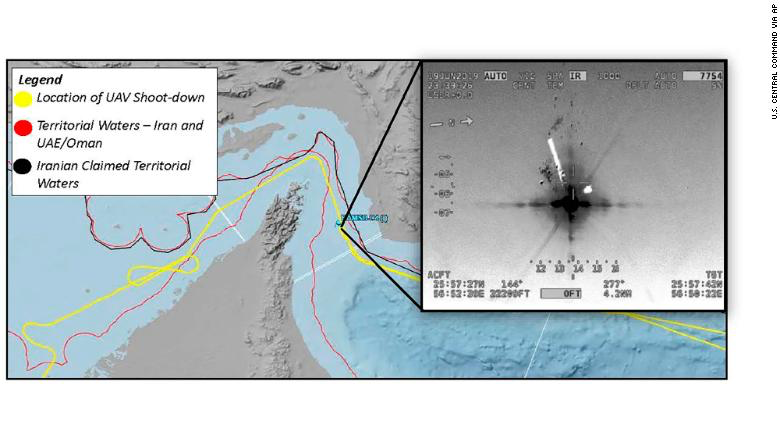
Or, as the U.S. Military’s Central Command tried to assert with its own parallel graphic of where the drone was downed, showed the apparent intensity with which Iran was able to pursue the dominance in a theater of oil transport vital to the global energy economy, and to the global economy that was attached to it, signaling a real Achilles heel in the continued image of American global invulnerability. which the United zStastes was determined to map as occurring outside Iranian sovereignty as an attack on American property and super-costly military hardware–starting a war of maps on the heels of a renewal to past Tanker Wars, both possibly poised to escalate into actual military bombardment.
It certainly seemed that the downed Global Hawk would constitute something akin to the arrow fired by the Trojan Pandarus into the groin of the Spartan Menelaus, the great warrior and husband of Helen of Troy, causing blood two streak down his legs, in an image of the fraught virility of the fabled warrior to incite the wrath of the leader Agamemnon, if not reveal newfound imbalance of military relations which Athena seemed to use to provoke the shattering military disaster of the Trojan War by starting the siege of Ilium. Would the downing of the jet provide the occasion of the bombing of Iran that Donald J. Trump has hoped to begin, matching his heightened bellicose rhetoric with the presence of a violent escalation of arms?
What happened was not clear, as was evident in the difficulty of mapping the event. When the costly U.S. Army Global Hawk drone looped back in the course of its surveillance of the Strait’s coasts, possibly entering Iranian airspace, after it was shot down, reverberations spread across the world, quite quickly. President Trump declared that Iran had shown itself by this act to be “ready for war” before plans for a miltirary reprisal were called off with but hours before it was poised to begin–perhaps saving the world from a global catastrophe, although U.S. Secretary of State was later dispatched to forge an improvised alliance against Iran in the coming weeks. Although war was averted on a global scale, the question of whose map was more authoritative, and whose could be trusted, reveals much about the contested status of authoritative maps in the globalized world, beyond being a debate waged across social media. The debate turned on different ways of reading space–or of wanting to read space; one hinged upon a notion of national boundaries and sovereign space, whereas the other relied upon the frictionless space of a notion of regional surveillance.
The downing of the drone lifted a corner on the shifting tensions in globalization, and indeed the increased problems of lamination of multiple maps over the increased density of economic traffic across the Strait of Hormuz, and indeed the conflicts between national and international waters along which petrochemical and crude petroleum leaves the increasingly blurry–if much mapped and over-patrolled–region of the Persian Gulf. The tensions were not about the drone. At least not only. The ratcheting up of tensions with a policy of “maximum prsssure” and rhetorical escalation has ratcheted up tensions, as Iran policy has been transformed into a flag-waving exercise of defense against a perceived infidel enemy–one that has disdained civil discourse and alleged overtures of open negotiation–in ways that are about American desires to map “international waters” and international airspace–
–rather than recognize even the potential legitimacy of a sovereign state’s defence. For all the mapping of “national” spaces on new maps of the region–that for all their identification of names of nations affirm the abilities and potentials of U.S. surveillance maps.
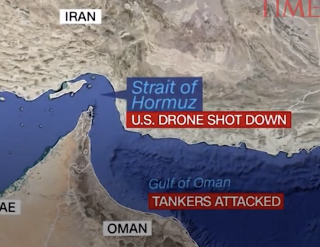

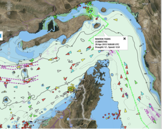
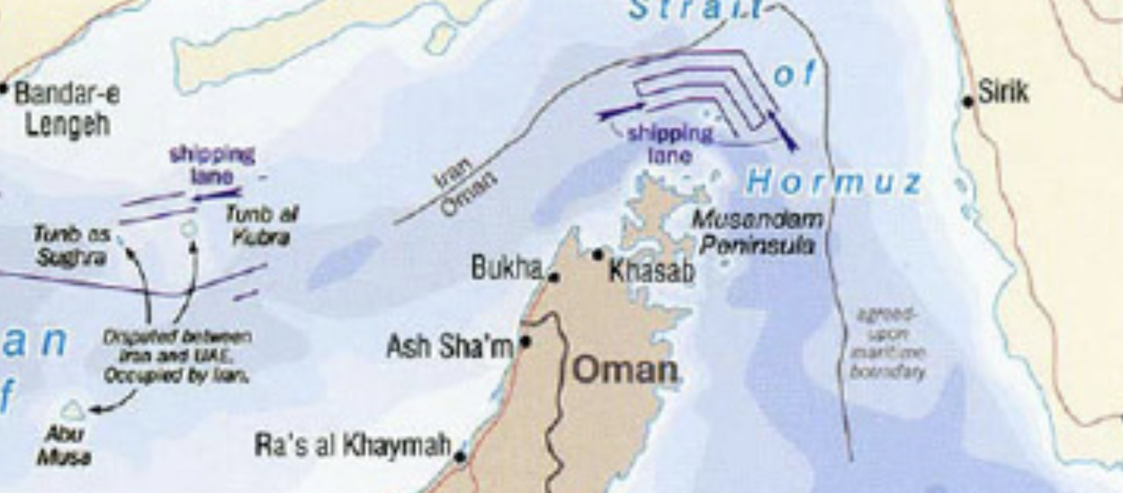
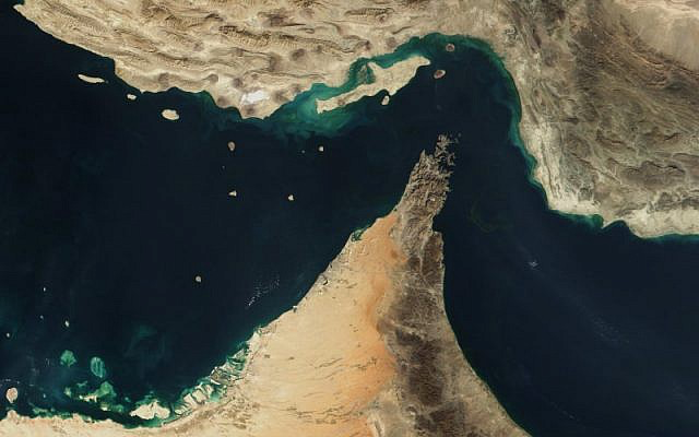
The Strait of Hormuz exists on the borders of several nations, and might be mapped in multiple ways. While the central waters of the Strait–which narrows to just twenty-one nautical miles, or less than forty kilometers–nonetheless retains a thin band designated as international waters, which puts it outside of local sovereignty. But the Strait increasingly is mapped in radically different global and local contexts, making the question of its territoriality and international status a question of increased tensions in the past weeks–when one American Global Hawk, a pretty fancy piece of surveillance, was downed. The cost was not only limited to the fourteen million dollar piece of military hardware, or to its symbolic loss, but the casualty of a sense of security in the frictionless policing of an economically vital transit routes–and the hegemony of mapping and ensuring the safety of the movement of crude oil from the Persian Gulf to global energy markets.
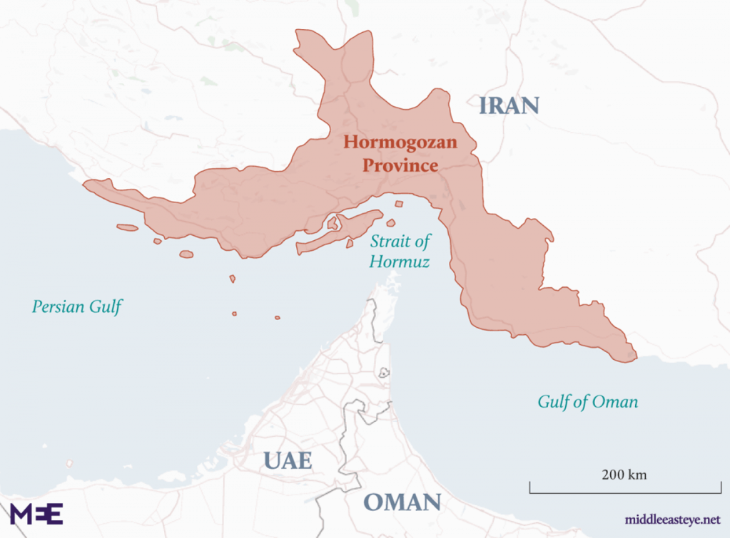
What appears to be a navigational course, in an era when territoriality is designed by points, rather than either landscapes or terrain, created an increasingly serious a quandary for measuring locations along a nautical map alone, or in reference to a mainland. For the question of incursion in territoriality–as the high-grade U.S. Army drone that was shot down in Iranian airspace–is not so evident from the Gulf waters, or the landscape over which it flew, approaching the Islamic Republic of Iran’s sovereign region of Hormogazan Province, or appearing to stray outside of the path of international airspace, or at least doing so at a height of 20,000 meters, higher than Americans’ expected Iranian radar systems could detect, but in fact just within the Iranian Revolutionary Guard’s radar detection abilities.
Was it an incursion of sovereignty? It depends less on whose maps you are looking at, than what sort of landscape of military conflict and geospatial intelligence you followed, or what side of the cat and mouse game of mapping the nature of the international status of the navigational paths of the Strait you follow to understand how securing “free passage” through he Strait of Hormuz became rooted in the security of abilities of mapping energy transit. If the Strait has emerged as a hotspot in an increasingly irrevocably globalized world, the conflict between Iran and American interests arose as abilities of local mapping temporarily shifted, and the hegemony of American mapping of gulf waters was challenged, as Iran accused the United States of crossing a long drawn “red line” of sovereignty in spying on the banks of a Strait that Iran has increasingly asserted its ability to close, and indeed to monitor the escalating American surveillance of its waters and shores.