As we face an age when the norms of legal conduct in the United States stand to be shredded, we have been suggested to benefit from looking, both for perspective and solace, if only for relief, to fantasy literature as we await what is promised to be a return to normalcy at some future date. If Trump’s unforeseen (if perhaps utterly expectable) victory has brought a sudden boom in sales of dystopian fiction, as new generations turn en masse to George Orwell’s Nineteen Eighty-Four, Margaret Atwood’s Handmaid’s Tale or Aldous Huxley and Arthur Koestler for guidance in dark times. The search for points of orientation on a disorienting present is of course nothing new: much as maps of rising rates of mortality from COVID-19 brought a surge in popularity of Albert Camus’ The Plague (1947), an incredible sales spike of over 1000%, alternative worlds gained new purchase in the present. But we look to maps for guidances and the stories of time travel and alternative worlds were suddenly on the front burner. For the surprise election of Donald J. Trump that may have been no surprise at all prompted a cartographic introspection of questionable value, poring over data visualizations of voting blocks and states to determine how victory of the electoral college permitted the trumping of the popular vote; hoping to find the alternative future where this would not happen, the victory of Trump in 2024 provoked a look into the possible role of time travel in a chance to create alternative results about the stories that the nation told itself of legitimacy, legal rights, and national threats.
We had turned to fiction to understand new worlds during the pandemic. The allegory of a war mirrored the global war against the virus–and provided needed perspective to orient oneself before charts of rising deaths, infections, and co-morbidities in the press. Camus became a comfort to curl up with in dark times, to help us confront and imagine the unimaginable as Camus’ text gained newfound existential comfort. A friend insisted on ministering stronger medicine by an audiobook narration of “Remarkable occurrences, as well Publick as Private” in Daniel Defoe’s Journal of the Plague Year (1665), mirroring our own helplessness in spite of modern science, putting the seemingly unprecedented topography of disease in another perspective. London, that global capital which seemed mistaken for the world to many, was transformed as it lost a good share of its population–an unprecedented 68,596 recorded deaths is an underestimate–as the spread of bubonic plague spread brought by rats created the greatest loss of life since the Black Death, permeating urban landscapes with what must have been omnipresent burials, funeral processions, grave-digging, and failed attempts to hill or quarantine the infected–as if it were a land apart, sanctified and ceremonialized to confront death in suitable ways. But t he public trust that had been seemingly shattered by the pandemic–trust in health authorities government oversight, and expertise, led us to turn to past realities as some mode of exit from the grim present.
As we seek reading with new urgency as alternative means of intellectual engagement, the fantasy literature that C.S. Lewis and J.R.R. Tolkien wrote in Oxford, as members of the Inklings, a society meeting regularly in a pub, if not Merton College, sought to create such durable architectures of alternative life to explore. If both writers’ works have been studied as a rejection of modernist poetics, rehabilitating old genres and rooted in premodern poetic visions, the centrality of the maps accompanying each have perhaps been less interrogated as a source for their deeply enduring immersive qualities–and indeed for the durability of the alternative maps to the imaginary that both offered. In recent weeks, a wide array of fantasy books reaching bookstores beside apocalyptic fiction in ways that seem made to order, offering refuges from the present as forms of needed self-care; immersive fantasy books and apocalyptic fiction may be the most frequented sections of surviving bookstores that survive, sought out for self-help in an era of few psychic cures. And it is no coincidence that we also turn to the carefully constructed cartographies of these alternative worlds with newfound interest, immersing ourselves–not for reasons far from those their authors intended–in the mythic cartographies that might be familiar as sources of comfort, that it might make sense to examine the context in which the carefully wrought and designed cartographies of Middle Earth that were conceived by J..R.R. Tolkien and imagined world of Narnia were designed, as an alternative to the new cartographies of wartime that imposed a geospatial grid, in place of a world of known paths and well-trod roads of an earlier world. For the shift in the world that World War II created spurred Tolkien and Lewis to craft alternative worlds of resistance, in hopes for a future that might be made better, not only in a Manichaean struggle between good and evil they watched from Oxford, but to struggle with the future effects of mapping systems that seemed to drain or empty the concept of the enchanted world of the past–the literary “Faery” they loved–and replace it with a Brave New World of a uniformly mapped terrestrial coordinates that risked othering the wonder of the living world. But we anticipate.
In short, we all seem to agree, the newspaper of record found a bit of a silver lining the day before Election Day, fearing the election’s outcome, offering the consolatory message of reassurance there are “few pleasures as delicious” as the ability to transport us “far from our present realm.” Yet the role of illustration in mapping of alternate worlds has perhaps been insufficiently appreciated. And while Narnia and Middle Earth are both seen as a predominantly mythic construction of worlds, removed from the orientation to actual locations, or to the power of transportation to a purely mythic realm, the pragmatic mapping of mythical spaces were alternative universes, modeled on mapping an expansive reality on the national borders of an actually remapped world that privileged the actuality of place, continuity, and contiguity in a mapping of location and position of precision without any precedent in geodetic mapping systems of the Universal Transverse Mercator maps advocated by the British and American military, and increasingly relied upon by the German military in the Battle of Britain.
The meeting of these two eminent architects of the fantasy worlds of the twentieth century–C.S. Lewis and J.R.R. Tolkien–whose colorful literary works opened new portals for generations have been linked with richly detailed cartographic corpora of persuasive power to redefine fantasy fciton–are tempting to be seen as the consequence of some passionate creative synergy of defining paradigmatic models of escape. At the same time as two veterans of the Great War joined forces in hopes for curricular reform after the war in Oxford University by expanding the medieval readings undergraduates might be assigned, in hopes to expand a consciousness of myths and legends in the texts suited for postwar life, the skills of remapping mythic landscapes in response to the Great War depended on a deep bonds to a cartographer appreciative of the losses and absences of geodetic maps, and eager to help them draft the shores and contours of the “escapist” worlds of fiction that both Oxford tutor would start to draft that set new standards for children’s books and fantasy literature for the twentieth century, that demand exploration as an energetic writing of a counter-map to the new authority of geodetic grids of a uniform space, that focussed attention on the suspending of beliefs by the liminal spaces of the shore, the mountain ranges, and the living landscapes that the smooth continuity of the geodetic grid could not describe or reliably capture. As much as the two dons indulged in the creative power and shared love of William Morris, adventures of Lord Dunsany, and Norse legends, both deeply relied on the illustrations realized with the need for the actual cartographic skill of their common illustrator. For their versions of the literature of quest, Pauline Baynes effectively served as a needed midwife blending cartography and art by to render the palpable landscapes of shores still in need of defense.
Both men acutely realized the need for a good illustrator for their projects of fantasy fiction, able to engage younger audiences that they had little practice in addressing, but whose interest they sought to attract. The prominent work on detailed maps for both books not only reached toward a demand to invest new mythic landscapes with concrete presence for their readers, but to create a new map of the world: to restore an older map of the countryside, to be sure, and forests that were still enchanted with meaning for their readers, but to map the countryside in new ways, rooted not in dots and points but in the continuity of the land. If Karen Wynn Fonstad, a recently departed cartographer of Tolkien’s Middle Earth, confessed missing a sense of proximity to Tolkien’s “tremendously vivid descriptions” in reading after a few weeks, the landscape of the terrain of Middle Earth persuasively offered a counter-world for many, lodged deep within our minds, as well as an escape from wartime when Tolkien composed their initial versions. The transportation powers of the text is real, and its exacting coherence demands a more adequate map than the new military maps of the global space defined during the Second World War, offering a basis to restore the lost sense of wonder that a point-based map elided, in order to provide the detailed landscape of a new form of meaningful quest, and to cast the novels as an opening up of new worlds in a world that seemed, inevitably, to be increasingly comprehensively mapped. These maps offered new spaces of exploration and proving that were outside the increasingly authoritative printed map.
The one-way ticket fiction offers may be deeply under-rated, but the map is critical to immersion in another reality. The Grey Lady of the New York Times indeed ominously but perhaps aptly marked the recent Presidential election’s results by offering orientation in this abundant field, providing signposts to a smattering of new fantasy books, as a response to the national exhaustion or real premonitions of fear. We rightly feel we are without precedent unwarrantedly–we’re confronting a loss of agency that seems unprecedented before the cocktail of environmental dangers of climate change, global heating, and an unprecedented circumscription of individual human rights, reading promotes a sense of agency, as does exploring landscapes outside of the present. If we feel alienated from the country that has again elected Donald Trump as President, to turn from blue and red states to maps of possible worlds form the past–we will need maps, as well as written narratives.
These worlds are however rooted in maps–maps of testing, maps of exploration, maps of selfhood, and maps of futures that are deeply lodged in our imaginations. They are not properly “possible worlds” but instead alternative ones, rendered by maps as regions that can be navigated along new orientational guides, attending to what is overlooked in other maps–maps of the nation, or of the world–by restoring or revealing overlooked orientational signs. If many emerged maps of new scales, dimensions, and resolution emerged in opposition to cartographic practices, the ways that Oxford–site of the Oxford movement, but a time capsule of religious devotion and royalist retreat from the present–became a site where the world was remapped in the interwar years, at the same time as the streets and urban fabric defining Oxford were facing new pressures, a layout bolstered by the archives of unbuilt architecture of urban planners’ dreams, and by the multiple patrons of college architects, among whom nurtured a neo-medieval architecture on fifteenth-century foundations of hammer beams, baroque screens, vaults, spans, and fans in a time-spanning style embodied by the perpendicular gothic in which were set carved gargoyles, plasterwork ceilings, and spires. The Palladian facades fantasias and architectural follies of Christopher Wren or Nicholas Hawksmoor (1661-1736) define a place apart, at an angle to the world, of expansive gardens, pathways among ruins of earlier times.
The poetic vision of a light able to pierce Mordor’s darkness and inspire a valiant quest for freedom was born in the neomedieval poem of distinctly Morrissian poetics conjured a counter world in wartime, as German troops invaded France, of a mariner whose course above the earth’s surface sought to preserve the last surviving shards of Edenic light. The complex backstory that he ably mapped for the poem bore the imprint of the earlier war, but crafted to an epic scale. If they recuperate old paths, fed by an Oxonian taste for re-imagining legends on anti-modern maps, drawn by illustrations and a stock of neo-romantic classicism, it was bolstered by an expansive philological apparatus Tolkien modestly called a consequence of being the “meticulous sort of bloke” not given to fantasy. Its maps opened powerful alternatives to the bloodshed and terror of the actual wars of the twentieth century as much as an Oxonian architectural fantasy.
The worlds of C.S. Lewis, Tolkien and others blur the imagined architecture of Oxford and romantic poetics of Morris served as “stock” to imagine an angle on the world, as a terrain that might be explored, and where a quest might still exist. Tolkien was hardly a utopian–and had little interest in “how worlds ought to be—as I don’t believe there is any one recipe at any one time” he described the invention of alternative worlds as that of a “sub-creator”–as much as seeing the author as a creators working with a large scale plan into which his readers were increasingly drawn. The appeal of these maps as invitations to alternative worlds has long been compared to the earlier traditions of cartography–cartographic conventions that formed part of the “stock” on which Tolkien claimed to have drawn in his work. Yet Tolkien’s skill as of illustration has proved to be quite a counterpoint to data visualizations, and indeed to the claims of comprehensive coverage of the world from satellite maps, or global projections, by offering the local detail of a conflict between good an evil that they lack.
In contrast to cartograms that have distanced viewers from the nation, or which suggest a nation grown increasingly remote in purely partisan terms, they allow us to inhabit those worlds in a refreshingly distanced manner, providing immersive senses of reality, as well as a needed perspective on the present. In the same years, Camus himself worried about the lacking landscape of moral imagination in the notebooks of 1938 that were the basis for The Plague,–feeling France could hardly contain Nazi Germany with honor, if it was not seen as a plague: in looking at geographic maps of frontiers, France was “lacking in imagination . . . [in its using maps of territory that ] don’t think on the right scale for plagues.” Thinking on the right scale reminds us of the current need for better maps of the imagination: we need counter-cartographies to the present as much as written works, of commensurate scale, involvement, and attention, as well as preserving a map of future possible worlds,–maps of superior orientation, fine grain, and moral weight to the current world. As much as rejecting the poverty they perceived in modern poetics, each constituted new maps of a world in need of adequate mapping tools.
Their “green worlds” are not pure fantasy; fantasy is a pharmakon for readers. The imaginative space of the written work opened up new absences of political space. In Camus’ prewar novel, Rieux, comes to fear the state’s role in spreading the plague coursing through in Algeria, Americans of diverging politics grew angry at the state policies for COVID-19 they blamed for the pandemic, lacking maps to describe where we were. While widely suspected that Donald Trump himself does not read books–Tony Schwarz doubted he felt inclined to read a book through as an adult not about himself in 2016, and Trump waffled about having a favorite book, citing a high school standard and explaining “I read passages, I read areas, I’ll read chapters—I don’t have the time” among his businesses–perhaps the act of reading is also one of resistance. This absence of any readiness to read may be a failure of the imagination, but also indicates an almost existential focus on the strategic role of deal-making in the present, managing a calculus of variables rather than people, accommodating to evils, and to sacrifice, more than empathy or the aspiration to human connection. The imagination of the moral theologian and philosopher C.S. Lewis to indulge in a children story, even without his own children, began from the domestic acceptance of actual children in his Oxford home from wartime London, it’s well known, when he penned the proposal for a new sort of story, not science fiction or serving more abstract theological morals, rooted in the adventures that he was able to imagine far more clearly of the displaced Londoners he housed–“four children whose names were Ann, Martin, Rose and Peter . . . [who] all had to go away from London suddenly because of air raids, and because father, who was in the army, had gone off to the war and mother was doing some kind of war work”–left to find new models of orientation to an enchanting Oxford countryside with little help from their host, “a very old professor who lived all by himself in the country,” who recedes to the background as a minor character as they are enchanted by their new surroundings. If Tolkien was a far more careful cartographer–far more perfectionist and academic in structuring another world–the alternative cartographies both constructed, this post argues, were midwifed by the illustrator both shared, who used her own cartographic skills to design their immersive worlds.
Creating viable worlds of otherness is an old art, but rapidly grew a far more complicated proposition in the years after World War II, a postwar period that was relentlessly dominated by new mapping tools. The demand for more expansive maps of the imagination paralleled the birth of Narnia and Middle Earth, expansive immersive worlds mapped in Oxford the respond to the claims of cartographic objectivity whose authority both authors whole-heartedly rejected in creating expansive atlases of purposefully anti-modernist form. C.S. Lewis and J.R.R. Tolkien imagined expansive green worlds in multi-volume fantasy books by Lewis or Tolkien as a new atlas paralleling the objectivity of the coordinate grids as the Universal Transverse Mercator, first widely adopted in the post-war period, as their works offered testing grounds for virtue removed from battle or transnational war: the green words of Middle Earth or Narnia may be tied to the success Henry David Thoreau’s bucolic Walden of a life apart won among World War I veterans, years after its publication in Oxford World Classics; but the expansive worlds one encounters in Narnia oriented readers not only to a new cosmography but an expansive atlas of fictional territory. Beyond anything William Morris had drawn or written, the influence of Morris on its writers–and on the woman who provided the romance of their different quests–acquired new scale, dimensions, coherence, and topographic density, orienting readers to landmarks that grew lodged in readers’ consciousnesses so that they seemed the transmission or recovery of previously unknown worlds.
The maps of an archeological recovery of a Medieval landscape of good and evil became immersive counter-worlds because they existed at a distinct angle to the authority of current mapping tools. Indeed, the expanse of Narnia, poised between Archenland and Ettinsmoor, defined not by natural geomorphological borders of mountain ranges, marshes, and desert rather than by abstract lines, without lines of longitude and latitude, grooves a uniquely suited testing ground for honor, duty, and valor of a timeless and mythic nature, suited for testing bravery and aptitude for a preteen; it is an atlas that unfolds in the sequence of books–here assembled from several volumes–that maps a world that was lost with the rise of maps of geodetically determined borders mapped by a grid to coordinate military engagement, logistics, and the coordination of ground and air travel. Its maps are dominated, appropriately but the faces of a sun that peers out from the mariner’s compass rose–and by the natural worlds of forests we are in danger of overlooking, not as so many lost green worlds but as living landscapes.
Narnia Maps by Pauline Baynes, assembled from the Endpapers of Volumes in Chronicles of Narnia, 1950-1956
As he waited rather glumly for “the Feds” to arrive at his home, as his stepfather predicted, Airman First Class Jack Douglas Teixiera may have pondered why he had posted classified maps of heated battle fronts in the Ukraine War to Discord was aware he was speaking to a much larger audience of interested readers than he ever considered. Teixeira’s friends defensively stuck with him, explaining the enlisted airman was a peaceful anti-war man, who “just wanted to inform some of his friends about what’s going on” as if the global battlefield was seamless with video games. Many in his largely male circle even had buddies who were actually fighting in Ukraine. He felt for them. The appearance of a mass-drop of top secret government documents must make us wonder not only about the restrictions on secret military information–and the security of detailed surveillance maps–but of the remove of the interest in the maps as cool images from the war they describe.
Texeira, who has been described as not a leaker like Edward Snowdon, but just a normal guy, had a preternatural passion for scoping out the battle-plans of Ukraine, profiting from the security clearance to “Top Secret” files he gained just two years after joining the National Guard. From his perch in Cape Cod, Teixeira had the sort of a privileged perch to read intelligence–and a gamer’s keen eye for detail of a war scenario–that you have to wonder what sort of division he sensed between the video games he enjoyed matching wits in post-apocalyptic scenario and the sense that he knew many who had shipped off to fight abroad, as he might soon, and the eager attention of a family who were proud of the uniform he wore to report to duty at the 102nd Intelligence Wing of Otis Air National Guard Base to manage and troubleshoot critical communication systems. As more information flows about global battlefields are routed and monitored from decommissioned Air Force stations in bases no longer charged with flying missions, the expanded intelligence-gathering function of drones leaves many watching large flat-screen monitors, removed from battlefields–or the battlefield terrain–
–participating not in airplanes, but in new tasks of surveillance, intelligence and reconnaissance that provide the basis for information-gathering that are deemed adequate for global war–“robust, multi-intelligence processing, exploitation and dissemination (PED) activities” that reflect the new architecture of the distributed networks of what global war. As Reaper drones fly above the Black Sea–over “international waters” outside the exclusive economic zones nation-states claim as part their national waters–even as Russia has from 2016 sought to transform the Black Sea’s waters, in the words of NATO Secretary General Jens Stoltenberg, “into a Russian lake.” Russia has annexed the continental shelf entitlements national waters of the Autonomous Republic of Crimea–shelf entitlements once belonging to Ukraine–for gas and sand mining guarded by air defense systems of its Black Sea fleet, the Russian navy has obstructed up to a quarter of the Black Sea–
Black Sea Regions Russian Navy Shut off from July, 2019
–laying effective and actual claim to its territory, American Reaper drones have maintained regular flights to monitor the battlefield, gathering intelligence about the Ukraine War from 50,000 feet, and increased their surveillance flights over the region from 2022. The new mission of gathering ‘sensitive intelligence” depends on flying over what America still considers international waters–
–although the dispute of how close the aptly named Reaper drones or Global Hawks might fly to the coast of the former is contested, and every nautical mile from Ukraine’s coast and the Crimean airspace compromises the amount of military intelligence that they can gather–and U.S. military intelligence was increasingly eager to expand drone flights to Russian-held territory in March 2023. The latest intervention in this ever-expanding theater of distributed war was, improbably, in Cape Cod. What has been called a “casual theft” of Top Secret intelligence of battlefield maps were sites of endless curiosity to the American Airmen who seems to have used their access to the monitors to take photographs of the maps over a few months, posting them to a gaming network. Jack Teixeira snapped shots on his iPhone of hundreds of maps of military scenarios, foreign land and air defenses, systems designed to deter Russian missile attacks “to defend [Ukraine] against Russian aerial attacks from all latitudes, and other documents from top secret spy satellites, signal intelligence, and infrared sensors. He included, for added interest, detail about mounting troop losses on both sides over time, with unclear appreciation of their actual geopolitical significance.
Rather than “stealing” the intelligence for a spy network or secretly embedded moles, the map that dropped on social media suggest the hidden vulnerabilities of expanding distributed intelligence from increasing drone flights across such distributed intelligence networks. Even as Ukraine insisted that these were outdated information about “constantly changing positions” in an entrenched territorial war, where positions shift in a war of attrition, the projections of the depletion of air defenses by mid-April or early May suggested a dwindling of resources that coincided with the debates on providing long-sought surface-to-air missile systems and a Patriot Missile System just arrived in Ukraine to defend Ukraine’s borders. Borders were, of course, in flux and up for debate as the intelligence collection of MQ-9 reaper drones, as the one that Russian
Airman Teixiera and other gamers liked to kick back by imagining a survivalist scenarios in the past. Part of this online sociability was boasting of his ability to share early info about the coming invasion of Ukraine, noting the intel on casualties on both sides during the war to his best buds on the internet, life-time non-disclosure agreement signed or not. As well as describing Russian boots on the ground and predicting plans for invading Ukraine, his circle enjoyed using their skill navigating the undead that populated the post-apocalyptic landscape of a future Kentucky, in a zombie apocalypse: legions of zombies where death is not only inevitable, anthropophagy all too real a threat for its players. The game seeks to capture a palpable thrill of death in the immediacy of its fictional topography, levels of risk distinguished by the revelation of hidden appearance of the undead meant players have to face the sudden possibility profuse bleeding lies just behind a door or around the corner as they navigate zombies invaders in a rural America of a not distant future. Weren’t the maps of Ukraine’s forces a similar rush of navigating a tight spot for the gamer group known as #War-Posting? Approaching real war with truly vertiginous proximity, the military slides suggest a terrifying landscape of death, with real time troop fatalities on display.
This is in fact not far from the actual daily scenario soldiers regularly face in many outposts of the Ukraine War, as Ukrainian soldiers hunker down in hopes of defending actual bombed-out cities like Bakhmut and other war-torn landscapes. But the daily tallies of war dead in Ukraine seemed to be rising so quickly in Teixeira’s daily posts on Ukraine battlefields from NSA and CIA records, dating back to February 2022 or over a year ago, that Ukraine must have almost replaced Zomboid for its cool factor, before he shifted to the Discord platform in December. The photos of paper maps of military groups of the Russian forces, Wagner forces, and Ukrainians provided a game-like view of war.
The leaked slides showing actual battlefields–“Here, have some leaked documents!”; “I have more than [merely] open source info–Perks of being in a USAF intel unit!”–fed our collective interest in geopolitics in ways that made them appear quite eerily much more seamless with imagining oneself amidst an apocalypse. They circulated mostly among gamer groups who liked to visualize themselves to, by some sort of futuristic time-travel, and one can imagine them teleporting themselves instantly from a war-torn rural Kentucky in which deadly zombies threatened their lives, hidden in dark corners and around doors, to Ukraine, from the pseudo-military landscape of omnipresent threats to actual war. The internet became a source not of leaking, but sort of platform designed cyber transport systems specialist, processing top secret military intelligence briefings from his base outside Boston, in Cape Cod, uploading hundreds of slides of real-time intelligence on a global scale arriving from the Office of the Director of National Intelligence, National Security Agency, and CIA, beyond intel collected from drones, to many friends.
Project Zomboid
The early maps that showed the expansive battlefield of Ukraine, so removed from his station in Massachusetts, shared a board-game like image of the war that had a real-life frisson. To be sure, Teixeira did condemn the military as run by “the elite politicians,” but loved war games. If the earliest maps leaked anticipated Russian military advances into Ukraine, rather than trying to leak military strategy, or suggest an interest in geopolitics, Teixeira seems to have been fascinated by toting up the daily tally of war dead on the battle field of Ukraine, sitting in his base, posted fatalities of Russian and Ukrainian troops–some argue that he diminished the losses of Russians, or augmented the number of Ukrainian military fatalities–as the military conflict maps became an inside running narrative of the war. This was not Daniel Ellsberg or Edward Snowden: there was no horror about war, but rather a sort of vertiginous fascination with the scale of death of one practiced in war games, ready to appropriate battlefield intel to encounter the frisson of true Thanatos, without much Eros available to the eye or mind.
Paper Map from Group Shared by Airman Teixeira on Social Media from January 2023/BBC
The enumeration of the tally military dead on paper maps to which he had clearance and privileged access–by all accounts sensitive information–became a glorified killing fields in which Teixeira seems to have realized his friends would delight more than Zomboid, with an eye to the cool factor of classified information. In the ecosystem of attention, the highly classified maps of the Ukraine War have been reposted and reshaped, occurred with little sense that their audience was with real-world interests, or that the scenarios they described were real. “This guy was a Christian, anti-war, [who] just wanted to inform some of his friends about what was going on” on the other side of the world, even if it was in the daily news, said a friend from the online community, defensively arguing that some of his fellow-gamers were even in Ukraine, and they were thinking primarily of their personal ties to them.
Did the gamers just want to inhabit the landscape of combat that was even more “real” than existing gaming situations, zeroing in on the fatalities and deaths in the fight for control over real terrain in Eastern Ukraine–
–at the same time as everyone in the world was trying to use the best geospatial intelligence to assess the fight over contested terrain, watching daily updated maps of the battle over the last year, in hopes to follow the gains of Russian forces around critical combat points like Bakhmut, that so sharply contrasted to the rapid gains Russian forces had made in the military offensive in Luhansk.
As the lines of military combat were contested, and media footage was posted of military advances into social media networks and messaging channels, the attacks of Russian advance moved slowly, being able only to capture small slivers of terrain in weeks of fighting Ukrainian defensive positions, often raising questions of why they were less able to exploit battlefield geometry and Ukrainian defenders relied on their effective degrading of offensive positions in a war of attrition. After months of very marginal territorial gains against Ukrainian forces, fundamental limitations of on gaining substantial grounds had begun to appear, adding a new dramatic quality to the war. In short, this made compelling stuff, difficult to fully track in words, clearly part of a global war dynamic more interesting to navigate than the zombie wars back in the alternative future of rural Kentucky. Thumbing his nose at military authorities, Teixeira used the pipeline of classified maps he had access even to compromise military theaters globally, using his phone to shoot secret information about Canada, China, Israel, South Korea, the Indo-Pacific military theater and the Middle East.
Teicheira, in a sense, was acting in ways akin to Edward Snowden, his head burst from processing reams of geospatial information that were impossible to fully get one’s mind around, even if Teixeira’s actual reaction to the challenge were of a very different ethical stamp. For this spate of over-sharing of slides was not really only about Ukraine. It rather offered a sort of ecoysystem that existed at an angle to the world: “We like fighting games, we like war games,” and the more real, presumably, the better. And the maps of real population centers, front lines of operation, and key assets–a vocabulary and graphic syntax that was troublingly–or maybe not so troublingly?–akin to a game board or a board game, even if it was labeled “SECRET//NOFORN.”
It must have seemed pretty cool when it was making the rounds on Discord online in early March, and then eventually migrated onto 4chan by April 5, 2023. By then, the widening online circulation of the maps created such an international kerfuffle to compel U.S. Secretary of State Antony J. Blinken and Defense Secretary Lloyd J. Austin to try to explain the commitment of the United States government to prioritize “safeguarding intelligence” even as the carefully sourced lightly encoded battlefield assessments of air defenses and discussions of military capacities of each side globally spread, and the Discord group known as #War-Posting improbably intersected with a real war, and Thug Shaker Central shook down from the trees some seriously large fruit. It was perhaps not any surprise that Jack became promoted as a poster boy for the MAGA crowd by @RepMTG, the MAGA megaphone, quick to defend the “white, male, christian and antiwar” man who promoted the man-child they recast as “an enemy to the Biden regime.”
And the Airman who violated his life-long nondisclosure agreement with the US government became a “kid,” a renegade American speaking truth to power, as he was praised for having finally “told the truth about [American] troops being on the ground in Ukraine, and a [whole] lot more,” on FOX, warned Tucker Carlson. Carlson’s media megaphone liked to circle back to Ukraine, and he hardly hesitate praising Teixeira as an American hero of real principles–unlike the American administration that has committed to defend Ukraine’s sovereign borders. Indeed, he cast Teixeira’s arrest for criminal activity as a form of telling truth to power–making a poster child of the Airman’s leaking beneath a menacing image of the actual Secretary of Defense, Lloyd J. Austin, seemingly designed as if a mug shot to make his shiftiness appear all the more suspect to entrust American troops.
Carlson claimed far deeper interest in geopolitics than the Airman ever expressed. From his Fox News platform, Carlson praised Teixeira for a principled stance, while overlooking the illegality of posting classified military information on open servers. For critics of American military involvement in Ukraine, as Carlson, the feds were moving to “destroy him,” targeting the “kid” whose release of top secret maps was red meat to Republicans already eager to cut American ties to Ukraine. Carlson couldn’t know that this was within his final weeks as a Fox anchor.
He asked his audience to overlook who is the criminal, describing the maps as revealing a board-game of Ukraine War as the battle-ground of a proxy war between American and Russian troops America had accepted, as Carlson described them as revealing what j the “war machine” of the national news media ignored but the slides “reveal that this is very much America’s war,”–that the Ukraine War is really between the two prime nuclear super-powers on earth, together with the Biden administration encouraging war crimes with aid of the mainstream media.
Domestic politics seemed to trump international relations; the leaker was championing of this leaker by both Tucker Carlson and Taylor Greene–who sits on the Homeland Security Committee in the U.S. Congress. Was Taylor Greene illustrating she might not be the best person to trust with national security information of any kind? Her readiness to tweet out secret maps monitoring troop positions and deliveries of military materiel, estimates of military capacity on the ground and more, if irresponsible from a national security standpoint, set a new standard for amplifying actual leaks. As if to deflect media attention from Russia’s behavior on the battlefield, the leaked maps served to deflect attention from the stakes of the Ukraine War, a chance to unmask an extensive cover-up by the Biden administration.
Teixeira’s leaked slides raised a specter of “mission creep”–an escalation of involvement far beyond stated goals, an echo of Vietnam or Afghanistan, a military expansion far beyond arms transfers, long threatened as a domestic risk for America, a “blank check” or irresponsible statecraft–Carlson promoted the problems with the presence of “much larger presence of CIA and US Special Operations personnel” than acknowledged, as the Airman revealed–and became emblematic of–a secret expansion of a hidden war in which the Biden administration had involved the United States that “Ukraine is actually loosing,” Carlson told his viewers. This “leaker” was a hero. Teixeira–“the kid”–has become cast by the White House and its cronies as a “criminal” who needed to be apprehended by federal forces, but who had taken their own eyes away from real questions of national security in sending forces after “the kid” who is a patriotic American.
We all know that Carlson was among the more vocal critics of American military assistance to Ukraine in any form. He happily spread anti-Ukraine propaganda on Fox, when he confessed he “secretly root[ed]” for Russia in 2019 as if he were the spectator to a conflict he had no stake in–“Why do I care what is is going on in the conflict between Ukraine and Russia? Why shouldn’t I root for Russia? Which by the way I am.”–and America had no reason to “care” about, but in which “we should probably take the side of Russia if we have to choose between Russia and Ukraine.” Teixeira’s gambit became enlisted as a reason to shift American viewers’ attention from the extremely brutal war crimes that Russia had performed against civilians, converting the actual war in Ukraine to a set of leaked maps that proved the endangering of America’s global interests.
Tucker Carlson Tonight, April 13, 2023
Why was this unprecedented leakage of top secret maps seized on by the MAGA media to decry American involvement? If so, why was the twenty-one year old Teixeira styling himself by online avatars like TexKilledYou, popular on military focussed social media platforms primarily for his survival games, as if he was enjoying being a marketer of a more real survivalist death gave of his own design? Was being a leaker a sort of IRL survival game, in some bizarro way?
Carlson spun it eagerly as a question of deep patriotism. Carlson used the story of “the kid” as if to magnify Americans’ fear of military escalation in Ukraine, as it offered evidence, even if Vladimir Putin dialed down nuclear threats, of the threat that “the United States is a direct combatant with Russia” and “American soldiers are fighting Russian soldiers”–even though, as Greene affirmed, when she shared her own copies of the removed maps, “Russia poses no threat to the United States.” The proxy war was hard to read in the maps, but the legibility of the maps was not really the question, after all. The level of detail on military operations that American forces were witnessing offered enough–military monitoring and intelligence assessments of troop locations and battle plans–to suggest a proxy war that might escalate into a nuclear exchange.
The detailed monitoring by American forces of intelligence projections resonated with Putin’s charges that the United States seeks to undermine Russia’s sovereignty–and seemed to obscure that it was the invasion Putin staged and organized that was explicitly aiming to end Ukraine’s existence as a sovereign country. The social media drop to the gaming group Thug Shake Central was neither partisan or ideological. The document drop was primarily shared for its coolness included a reveal of future plans for a buildup of Ukrainian forces–a subject that dominated global media sphere–and maps that project a range of eye-opening”wild- card scenarios” stunning as they imagine a range of potential escalations of the theater of war–as well as a negotiated end to the conflict–including a Ukrainian strike on the Kremlin itself and the death of Russian President Vladimir V. Putin, a scenario of a level of violence that was not ever openly described. To be sure, there were many things that were not in the maps, that we might do well to focus upon, instead: the six million internally displaced residents of Ukraine since the invasion began, and the eight million that have fled the nation.
Neither do we see the status of Ukraine’s invasion as a potentially pivotal place in global theater of war–or the fact, all too often elided in maps on the ground, that whatever scenario occurs, Russian possesses the greatest nuclear arsenal in the world. For Tucker Carlson on FOX, “the slides show that this is in fact not Ukraine’s war, it’s our war,” Tucker Carlson affirmed, arguing that it showed that “this is not a regional conflict in Eastern Europe, but this is a ‘hot’ war between the two primary nuclear superpowers on Earth,” suggesting that the Biden administration was concealing the global stakes of Russia’s quite openly imperial stance to an expanded “sphere of influence” on a truly global scale–including Armenia, Syria, the Middle East, and Africa, or the global nature of the over 10,000 sanctions that were imposed on Russia after its invasion. The permanence of Russia’s claims can hardly be called out as not regional–if one looks at the maps that Russian forces have plastered themselves in cities like Kherson, claiming to be “here forever”–
“Russia is Here Forever,” Kherson January 2023/(c) Anastasia Magazova
–or the maps of the sanctions that forty six countries have placed on Russia, aware of the danger of the expansive military claims Russia is unprecedentedly staking in a zone where Ukraine stands at the epicenter of a global crisis in democracy where Russia has tried to impose its will on a nation.
February 20, 2023
There was little interest in revealing the presence of American forces abroad. Wasn’t the strategic mapping of military forces in the slides, however, not the reason for the interest in posting the images to a group of serious gamers on Discord in the first place? While the slides bracket the question of whether the invasion of Ukraine was not a global crisis in democracy, this would be bracketed in the sort of strategic maps that Zomboid fans might like to focus, finding the cool factor in the on-the-ground strategic questions of life and death, where no real values exist save questions of brute survival, more than the real threat of unfolding a war of stabilized conflict that is the entry point of a new Cold War, and growing battlefields which have only victims. The Biden administration, one might almost sense, had been waging their own war games in Ukraine against Russia–never mind that they were the active aggressors–that the American architects of the war sought to keep hidden from the American people.
The military maps leaked demand some attention, however, in themselves. Was the increased realism gamers have come to demand from combat games like War Thunder–where several secrete military documents appeared in January–including the diagrams and system manuals for military aircraft not yet in production–spread to reddit, meriting wrist-slapping from moderators made about leaking “export restricted or classified documents” in internet arguments escalate to federal crimes, an example of the increased confusion of gaming intensity and the ethics of public communication? The whole episode reminds us just how much maps are about gaming, or gambits, as much as mirrors of the situation on the ground: the escalation of a steady flow of intel maps that the airman approved for full security clearance had spread on Discord from January to March before they ended up on the Minecraft Earth map server suggests not only how private unmoderated platforms migrated to a broader community, by a twenty-one year old who had gained Top Secret security clearance to “sensitive compartmentalized access” since 2021, and was familiar–if not curious–as an Airman to read maps projecting aerial strikes and interpreting aerial combat maps.
Jack Teixeira may not have intended to post the intelligence documents marked “Top Secret” about the Ukraine War in specific. He posted them to a channel of video gamers. To be sure, he’d tried to process the documents he had access, describing them as best he could as detailed summaries that he hoped would be exciting for his fellow-gamers–even if some of the analyses of Russia’s invasion of Ukraine and include images of the hotspots of war in Kharkiv and Bakhmut, some of the most intensive areas of combat, Ukrainian air assets in the region, as well as timetables of weapons delivery to Ukraine. Acting as if he was loosed in a house of secrets he wanted to process all around the globe reflect how much the Pentagon has become a clearing house of global knowledge. While both Ukrainians thought this was Russian propaganda cautioned they were western propaganda, and embarrassed Americans cast doubt on their official origins, the leaked intel gained international attention as they appeared on pro-Russian Telegram channels, including tabulations of Ukrainian and Russian war dead.
As many became skeptical of the authenticity of written descriptions of military engagements that Jack Teixeira had posted to his tightly knit social media circle of gamers, he tried to convince them as he began to post the images of documents from Ukraine War that were clearly marked “TOP SECRET”–as if to demonstrate their authenticity to his friends to assure them of the access he had to authentic records, soon bringing caches of what added up to hundreds of maps home to his dining rom table from January that he photographed on his mobile device, beside hunting magazines and sights for his guns. He was cumulatively releasing a hundred and then two hundred more of documents that would slowly began to make rounds on different sites with limited attention. The release of the cache of maps by Teixeira of the plans and projections for war was the latest evidence of the surrogate war that was being waged between nations and international alliances in Ukraine in a scorched earth fashion, but it was evidence of the scale and nature of a global war, waged on information networks and on the ground, based on intelligence as well as arms, the substrate filtered from global intelligence networks that was destined for few eyes–although when they appeared on a Minecraft Discord server beyond the far smaller American group they had first circulated, they quickly spread on 4chan, Twitter, and Telegram servers that entered the global media sphere in ways Teixeira seems never to have anticipated. Teixeira seemed shocked by the global intrigue–real discord!–the revelations spawned; an avalanche arrived four months after he began posting to friends, and in his final email messages as he quietly closed out accounts said farewell in a rather valedictory way, as if not yet registering the chances for his imprisonment.
The rather surprising auspicious kinship of his name to elegant cartographers of the early modern period was probably beyond Teixeira’s knowledge. Unlike maps of Japan celebrated early modern Jesuit cartographer Luis Tesiéra sent to Abraham Ortelius of Japan, from Spain, leading Ortelius to craft the first accurate European map of the island even if neither man set foot there, to be sure, Jack Teixeira had never set foot in these territories, but had perceived these theaters of war only from afar in news media, and seems to have tried to reveal a more real sense of proximity to the battle sights through the Top Secret maps. Jack Teixeira posted inside intelligence compilations onto Discord because they seemed real cool, or real and cool. The hand-painted planisphere credited to the Portuguese cartographer Abraham Teixeira of 1573 revealed the world amidst a chain of secrets of another sort–global spice routes–had a cool factor as well, to be sure, but far more tied to the globalism of another era, if in its detail and cutting edge for its day.
Domingos Teixeira, 1573 (Biliothèque nationale de France)
The global reach of these early modern nautical maps promised a new global coverage of sea routes. No one could assess the damage that Airman Jack Teixiera’s eager oversharing had caused, or its effects on the war, but the human geography of combat intersected with the geographic imagination of gamers in more explicit ways than we had been accustomed to admit. If the demographic of peace-loving military service who relaxed by enjoying war-games they imagined cordoned off from the real world is unknown, it is far greater than we would like to admit. It’s hard to imagine the intensity with which his gaming led him to remove, photograph, share, and repost the maps and other intel, as if he was reaching out to folks by entrusting them with Top Secret information on a medium that he must of known had global reach. Was the game of courting public revelation of his own breaking protocol by revealing state secrets part of the game?
Maps and secrecy are, of course, in the news in other areas this week, including that a map of sensitive intelligence information–this one we haven’t yet seen–was kept by Donald Trump from the White House, and after being taken to Mar-a-Lago perhaps displayed or shared, perhaps including military intelligence. Trump’s lawyer Christopher Kise questioned the imbalance in national security questions in the Biden administration by focussing on “some outdated map” Trump took to his resort in violation of national security protocols, but allowing “real wartime intelligence data is flying out of the door”–or at least being shared on social media outlets–trying to distract from how Trump took a classified map of “sensitive intelligence information” out of the actual White House door to keep it in his private possession among classified records he regarded as memorabilia or bargaining chips. Is the game of secrecy waged about the secrets in maps always as important as their contents?
This problem seemed to come from Hell. The “righteous strike” of a drone-fired Hellfire Missile killed Afghan aid worker Zemari Ahmadi, his nieces and nephews was America’s military doing what it did best–a targeted precision strike. As much as targeting a human target who was instantaneously dismembered as his car shifted into park, the “Over the Horizon” strike cell commander who fired the missile from the drone was firing at a coordinate, and trusting in its authority. United States Dept. of Defense spokesperson John F. Kirby vowed “to study the degree to which any policies, procedures or targeting mechanisms may need to be altered going forward.”
The strike was to be reviewed by former senior staff officers who served in Afghanistan, assigning it high priority as an event that was based both on the lay of the land in the territory of the strike and of the unique capacity and liabilities of drones to both survey the area from human intelligence it is fed. But Rear Admiral Kirby insisted that the strike was only green lighted after the American General at Central Command, or CENTCOM, who remained apprised of surveillance found “a reasonable certainty of the imminent threat that this vehicle posed.” The descriptors of a “reasonable certainty of imminent threat” was itself a wartime coinage, the inheritance of the contradictions of the drone’s ability both to provide impressively detailed imagery from both infrared and image-intensified cameras in the Reaper drone that killed Ahmadi, believed and claimed to having decided to act as an agent of the Islamic State by a car full of explosives, a misjudgment for which no military were ever punished, or ever will be, as the intelligence failure was attributed not to humans, but to a defect akin to software–“a breakdown in process, and execution in procedural events, not the result of negligence”–even if it was in fact unnecessary to protect American troops from a strike from the Islamic State that the drones had detected.
The CENTCOM Commander himself apologized, saying “we thought [we had] a good lead,” the balance between “certainty” and “threat” was not so clearly mapped as the pinpoint targeting of the vehicle, watched for over eight hours. As if in a surplus expenditure of energy at the conclusion to the war, or a final moment of fireworks, the huge discrepancy of wealth and technology between two sides was made manifest in the explosion that took the aid worker Zemari’s life with his nine family members, a final salvo of the Forever Wars. But the striking of the vehicle containing Ahamdi, and which his nieces and nephews surrounded, were perhaps the fault less of a human error–if that was involved–than of a desire for a new method of war conducted in alarmingly disembodied terms, in which “it is exceedingly important to shoot the missile, not at the target, but in such a way that missile and target can come together in space,” as Norbert Weiner wrote in 1948, in a classic work of communication networks in animal and machine, in which human judgement become part of feedback loops, but not ever making anything like what we might classify as ethical calls: the transmission of information in this model is based on the clear transmission of alternatives, and reduction of ethics to so much background noise, based on the probability of how much accurate information was available or at hand.
This conflation of viewing and mapping is a creature of the geodetic grid, now enhanced, as never before, with qualitative footage that is real-time, if incomplete. The widely touted surveillance abilities of the Reaper Drone that is able to transport laser-guided Hellfire missiles, and day or night radar, was the “first purpose built hunter-killer UAV,” a precision instrument run by real-time video feed by operators located thousands of miles away was not only a filmic experience as a video that guaranteed its own sense of accuracy, assured by highly refined abilities of mapping that, as all geodetic maps, offer the security of a grid imposed on experience, as a substitute for experiential knowledge, but extends the global network of American military bases into the city blocks of residential housing able to drill down to the very driveway in which Ahmadi was hit. If the justification of “imminent threat” the reaction time from the growing constellation of drone bases” in a secret network of airstrips across Africa and the Arabian Peninsula to assure global military dominance growing from 2013 in the Global War on Terror, to achieve a targeted killing program of which Ahmadi’s death is only the latest fruit. The network designed to ensure the safety of Americans was justified by the Legal Counsel to Barack Obama’s Justice Dept. in 2011 as allowing lawful killing of any member of Al Quaeda or its affiliates of “imminent threat” to the United States, a formulation first used to justify the killing the American-born Muslim cleric Anwar al-Alaki, and his sixteen year old son. If the white paper does not mention quality of intelligence sources, it gave broad legality to aerial killing, stipulating “imminence must incorporate considerations of the relevant window of opportunity” and possible collateral damage to civilians. The geodetic architecture of spatial precision created a new regime of imminence, locking targets into the sights of removed
The legal term “imminence” is balanced with a distributed network to dilute responsibility in ways oddly commensurate with the technology of death. The removed visual experience conjured by the Reaper is an ideal cartographic knowledge, equipped with all-weather, day or night radar, a sensor ball bearing image-intensified and infrared cameras in the gridded screen of a target, is unique. Its firing is rooted in an ethically unquestionable phenomenology of film that depends on “what the camera can see,” which legal historian Nassar Hussain argued refined a way of seeing that elides its own mechanical construction and claims a total experience despite its often partial picture of the target in question; it is also a bolstering of the smoothness of the decision to strike a threat that proceeds down the “kill chain.” The moment of impact is geographically removed but also problematically removed from any ethical contract among combatants: it is the most extreme threshold yet of the “maximum range killing” that Dave Grossman, an authority on the psychological impact of lethal force in war, defined as “a range at which the killer is unable to perceive his individual victims without using some form of mechanical assistance—binoculars, radar, periscope, remote TV camera, and so on.” For Grossman, the occlusion of visual perception creates a suspension of ethics unique in military psychology: “I have not found a single instance of individuals who have refused to kill the enemy under these circumstances, nor have I found a singe instance of psychiatric trauma associated with this type of killing.” It was this unique psychology of killing, cleansed of all trauma, it appeared, that ballooned in the military theater of war in Afghanistan.
“Imminent threats” were intentionally removed scrutiny of targeted killing from public scrutiny by a legal whitepaper, commissioned by the U.S. Dept. of Justice in 2011, to confirm the lawfulness of a strike against an “imminent threat” of any senior or operational leader of Al Quaeda or affiliates just after the height of drone strikes in Pakistan and as drone strikes in Afghanistan reached astoundingly routinized presence. But the equipment of drone with lethal missiles from 2001, in the heady early days of a Global War on Terror after 9/11, transposed the legal language commonly used as a term of justification, to targeted killings as the 2002 strike against Al-Harethi in Yemen from a secret American base in the Horn of Africa, and the growth of drone strikes in Pakistani territory, whose legality the US government had effectively confirmed as part of the state of war and the landscape of aerial warfare that was increasingly incommensurate in scale of destruction with the terrorist attacks on the ground or IED detonations.
American Drone Strikes, 2004-2014, The Economist
At a time when ISIS had effectively internalized the danger of a sense of western besiegement, and the United States had almost amplified its power to suggest that waves of besiegement were utterly insurmountable and impossible to defend against, the arrival of a final Over-the-Horizon strike of a Hellfire missile seemed a parting strike of particular cruelty, by accident effectively perpetuating the inevitability of a continued narrative of besiegement for the world; as the escalated pummeling of ISIS presence in the hills of Peshwar and Afghan provinces had provided ample evidence of besiegement attempting at exhausting the “enemy,” in record numbers, over a decade of intense bombardment focussed firepower one final time on a residential courtyard in Kabul were someone far away had judged an Al Qaeda affiliate was parking a carload of explosives.
There are problems of balancing an awesome strike ability of a Hellfire missile, a missile conjuring the eternal fire faced by the dammed with a “righteous strike,” and the scale of local damage it can cause: the death sentence that the missile passed as a remotely tracked technology of obliteration was invested with curiously religious terms, the fire of damnation a sentence of divine wrath, sending the fire of hell to the courtyard of a Kabul family residence to shatter the life of the wrong man who had been tracked for eight hours by Over-the-Horizon Strike Cell dedicated to disrupt the Islamic State Khorasan. But this time the Over-the-Horizon strike in Kabul was, if precise, focussed on the wrong white sedan, as the intelligence about the car that was being tracked for over four hours was terrifyingly incorrect. The poor debut of “Over-the-Horizon” strikes was a bad omen of the value of geospatial precision.
Afghan Neighbors Ponder the Courtyard of the Zemari Ahmadi’s Home in Kabul, Afghanistan Jim Huylebroek for The New York Times
Were the mechanisms for firing the laser-guided missiles encoded in the authority of the mapping tools that sent the laser-guided Hellfire missile to Kabul, as much as in faulty intelligence, and the limited guidance on targeting individuals? In what was almost a bravura use of force, American military drones fired Hellfire missiles as the airlift continued, on the eve of the United States departure, pointing to the appearance of secondary explosions as fireballs to indicate presence of explosives inside vehicles that ISIS operatives might drive into the airport for a second suicide attack. But if the strike was “deliberated” and the information military had collected “all added up,” the rules of engagement of airstrikes, as much as the human intelligence, implied deep ethical problems of trusting in the logic of maps to sift through evidence with greater accountability, especially as we seem to be approaching a threshold of increased engagement without men on the ground in Afghanistan, in developing an “over-the-horizon” strategy for the immediate future, as President Biden pursues his commitment to fight ISIS-K without actually increasing civilian deaths.
Ajmal Ahmadi, Mourns Members of His Family Killed byu Hellfire Missile in Kabul, Afghanistan, Monday, Aug. 30, 2021. Marcus Yam/Getty Images
The mechanics of the decision-making process that led to fire a drone that later killed Ahmadi and his children, nephews, and cousins is under review, but the verbal and epistemic confusion between what was first described as a “righteous strike” of vengeance, evoking the theory of “just war” that was invoked by President Barack Obama in invoking “just war theory” to rationalize the use of the military force not as a wanton or needless display of power and with the hope of saving lives to prevent the loss of lives, required, in his hope a “near-certainty of no collateral damage.” And while this was of course collateral damage of the most extensive time, the coverage of the extent of mis-targeting of believed terrorists reveal a terrifying cheapness of life, undoubtedly only able to be researched in detail for the jaw-dropping mistake of targeting of innocent civilians by a laser-guided missile due to the density of journalistic coverage of this particular strike, and journalistic presence documented the costs of erroneous strikes and the scope of civilian casualties as horrific as carpet bombing–if far more surgical–as if this were a far more humanitarian form of war whose precision could be labeled just. We were able to see the Taliban checkpoint that let in suicide bombers to Kabul’s airport, causing almost a hundred and fifty deaths, we became convinced of the ability of targeting precision strikes of the perpetrators of similar crimes, and amped up the intelligence networks to scour the city for signs of any activity appearing that it demanded to be targeted, and snuffed out.
Planet Labs Inc., image of Taliban checkpoint blocking access to Kabul’s international airport Saturday, Aug. 28, 2021 (Planet Labs Inc. via AP)
Precise targeting, unlike bombing raids of the past, provided this certainty, or was supposed to offer surety of not being needless. But if such near-certainty depended on a map, it rests not on the accuracy of mapping. The strike that killed Zemerai Ahmadi — and ten of his family members–was mistakenly categorized as a “righteous strike,” killing an innocent aid worker and his family members. While it occurred in the heady atmosphere of retaliatory strikes for attempt to sabotage the withdrawal from Kabul’s airport attempted to be just, the slippage between the logic of targeted bombing and justice became apparent. It was a lurch to affirm global strength, more than justice, in using a technology of geolocation that had evolved to coordinate hand in glove with surveillance from Reaper drones. The ability to pinpoint track the progress of one car tagged as an imminent danger.
U.S. Central Command maps movement across Kabul of white Toyota Corolla on Aug. 29, 2021. CENTCOM/via Military Times
The mistaken of surveilling and targeting a young Afghan civilian in a Toyota Corolla was terrifyingly akin to the senseless bombing campaigns of South Vietnam, North Vietnam, and Laos, or more terrifying. Surveillance of Kabul and its airport were much better than Vietnam, by remote satellite and drone photography, the ability of such targeting–and the rush of such precision killing–seemed to follow the logic of the map, as much as people on the ground.
1. The maps used to conduct action at a great distance in Vietnam were not as transparent or evident, but they were for the time. In the 1960s and 1970s, they offered grounds to pose the eerily analogous question of the extent and expanse of the globalist claims of American power. The trust in the accuracy of maps provided an eery precedent for the confidence in strikes an old theater of empire, a theater once defined by imperial maps. The surety of the strikes that the UTM and LORAN B offered to American pilots existed in two theaters–the arena of the map that determined the strikes and the geographical space to which it corresponded, and old imaginaries of imperial and colonial power. The British empire was driven from Kabul in 1842 and 1843, and the French hold on Indochina had led them to withdraw; as the mapping techniques of post-war Europe led the United States to inherit Southeast Asia, global technologies of mapping opened the possibility of launching strikes that would offer lasting reminders as America withdrew from the Forever Wars in Afghanistan, leaving as the English did from both Kabul and Kandahar, but, in an attempt not to be forgotten, leaving a lasting imprint of the power of long-distance bombing. If combatants of most all wars fight with different maps, often reflecting differences in military intelligence, both these post-colonial wars were defined by the drastic dissonance of radically different maps of geospatial intelligence, one from the air and one on the ground, and the pursuit of a stubborn logic of air maps as if they offered both superior exactitude and geospatial intelligence, modernizing the struggle for control by defining a logic of modern military operations by which to understand and to shape the “sharp edge” of war.
Carpet Bombing in Vietnam by B-52 American USAF Planes
The beginning of the end of American Empire has been recently pegged to 1972, a year that marked and took stock of the the end of a huge expenditure of sustained bombing drives with little apparent enduring accomplishment. The geospatial logic that drove such earlier long-distance aerial bombing campaigns in Vietnam were driven by perhaps misplaced confidence in how maps enabled and facilitated military action at a distance: maps offered a logic, if there was one, for conducting the over six hundred sorties and operations over eight and a half thousand miles away. There is an eery analogy that we have the most complete and exact database for bombing raids of the American military in Vietnam, coordinates that were painstakingly compiled by Americans, so analogous to the geodata of thousands of drone strikes in Northwest Pakistan and Afghanistan, from 2004-2018, that the New American Foundation asserts the vast majority–over 80%–of those killed, were militants, though the Brookings Institution counters that drone strikes killed “10 or so civilians” for every militant who died,; Pakistan’s Interior Minister complained vigorously that a preponderance of the killed with civilians–especially in habitual follow-up strikes, targeting those responding to victims of the first hit, targeting of funeral processions, or mourners, or simply less surgical strikes. In an attempt to respond to these attacks from above, the Taliban’s weapon of choice was improvised explosive devices–literally, IEDs, placed on roads and activated by radio signal, mobile phones, or triggered by victims who step on them.
Paul Scruton, The Guardian
The warscape that developed 2004-9 of explosive shells, made often from diesel or fertilizer, along the major Afghan highway by the border with Pakistan where the Taliban was geographically contained–an increased density of which was tracked by Paul Scruton in the screen shot maps to the right of the map. The first attachment of a Hellfire missile to a drone followed the sighting of Osama bin Laden by one of the Predator Drone of the sort that flew across Afghanistan from September 7-25, 2000, in search of the terrorist who was wanted from 1998 suicide bombings in two U.S. embassies, his first strike at American territory; the unarmed CIA Predator was able to laster-illuminate and geolocate him so that it tracked him fro almost four and a half hours, but he could be hit by a Tomahawk missiles, but the time-lag for firing Tomahawk missiles failed to guarantee a similar sort of accuracy; as the new tool of the CIA and US Air Force were mounted with Hellfire missiles, they sighted and shot at Mullah Omar in 2001, but missed him, destroying only his car.
When Barack Obama assumed office in 2009, he tweaked George Bush’s invasion of Afghanistan by rehabilitating the “just war” theory, of medieval origin, formulated by Christian and protestant thinkers. Obama chose to rely on the accuracy and surgical nature of precision strikes as surgical means of not striking civilians, or focussing on enemy combatants, although the berth of such distinctions lay in the military or CIA: ifAfghanistan became the terrain for “the future of our military,” where Predators defined the mobile “edge” of warfare waged overhead and across borders. Targeted assassinations by CIA and USAF targeted the Waziristan region, mapping the region with pin-point in the notion of a “just-war” theory, rehabilitating an ancient doctrine of right conduct in war–“jus in bello” doctrine of Christian thinkers–by modern tools of geolocation, leading to the escalation of pin-point targeting by drone-fired missiles. In the face of global opposition to the use of missile enhanced drones as tools of targeting objectives in war in the mountainous areas of Pakistan province where the Taliban had fled by 2011,–
Escalating Drone Strikes Targeting Taliban in Remote Mountainous Region of Waziristan
–and, from 2012, the CIA went out of its way to try to design alternate missiles to “shred” vehicles and their inhabitants, but without blasts, to attempt to minimize “collateral damage” or killings.
Hellfire Modified to Limit Damage of Bystanders, Used from 2012
By the time the final American forces were set to ferry the final civilians from Kabul, however, the logic of drone strikes shifted to the home front of Kabul, set motion by the terrifying suicide bomber who struck Kabul’s airport, killing 143 Afghans and 13 American servicemen. In what was either the last gap or new frontier of geolocated killing, drones targeted Hellfire missiles in pinpoint strikes across Afghanistan, in “just” retribution of the fear of further K-ISIS suicide attacks on the ground during the last days of American presence in Afghan territory focussed on flights departing Kabul, revealing an ability of surveilling, targeting and striking far into the country as American forces departed the ground, as if to alert the Taliban of the continued proximity of CENTCOM bases in Qatar.
However celebratory the drone strike seemed, hellfire missled that killed Ahmadi suggested the haunting return of a lack of justice on August 29, as twenty pounds of explosive struck the car of the breadwinner of an extended Afghan family, with seven children who depended on his work. The children who had rushed out to greet him as he pulled his own white Toyota Corolla into the driveway of his personal home were not seen by the man who fired the drone missile, who felt secure no civilians were nearby. As we examined footage to detect the alleged secondary explosion, we found a weird echo of the airstrikes of an earlier war removed from our continent. While much comparison between the messy tactics and poor planning American withdrawals from Vietnam and Kabul spun, the incomplete coverage of the “collateral deaths” of civilians from the strike led to the military’s eventual backpedalling of its story of striking ISIS-K as an act of counterterrorism or “righteous strike.”
It was only due to careful investigation on the ground that the horrendous mistake was discovered. Reporters used footage from security cameras to follow the forty-one year old aid worker before he was driver targeted by the Hellfire missile suggested the poor intelligence which operators of “strike cel commander” who had been operating the drone in Kabul. Even as we await analysis of the decision-making mechanisms, we wonder a the high degree of certainty in public statements, even as questions circulated from the start of accurate video analysis of an after-blast confirming, as was claimed, that the Toyota Corolla was carrying a payload of ISIS-K bombs, and the lack of a mechanism of review before the drone strike. The accuracy of targeting the car was questioned by journalists as Spencer Ackerman all too familiar from the targeting of civilians that had escalated in previous years. Although announced as compensatory for the deadly suicide bombing outside Kabul’s airport, killing Afghans and thirteen U.S. military, as a second drone strike on ISIS-K leaders in Nangarhar Province of an “Islamic State planner” in retaliation for the deadly suicide bombing–and entranced the world with the surgical take-out of the very operatives who allegedly planned the airport attack that killed thirteen American service men and 146 Afghans, as they rode a three-wheeled truck near the Pakistani border from 7,350 miles away in the Nevada desert, injuring an associate but killing the two men immediately. There was a perfect symmetry in the image of men who were riding in a tuk-tuk being obliterated by a strike that left a crater four feet deep.
While removed in time, the bombing campaigns in Vietnam have left precise geodata for bombing raids so comprehensive to be able to map cumulative raids over time. The result privileges strikes over deaths, in the eerily lifeless and quite terrifying record of Bombing Target Maps,–charting sustained campaigns of bombing at a distance waged in maps. This blog considered human costs of aerial perspectives both as a result of the acceleration of bombing campaigns in World War II and how maps jusfitied and normalized the Atomic bomb dropped on Hiroshima. As the longest and least accomplished use of maps to sustained military engagement at a distance, is impossible not to consider the retrospective view it offers and reveals on the logic of the role of drones in Forever Wars. Systematic carpet bombing of Southeast Asia was pursued 1965-1973 as if by a logic of mapping, escalating by 1972 in a failing attempt to illustrate global dominance. The increased exactitude of the map becam a rationale for the power to wage war from afar, both to compensate for a lack of information on the ground, and to compensate for more irreducible problems of distance: mapping tools promised a logic of the ability to operate smoothly across frontiers. The unprecedented global coverage of GPS coordinates was administered and run by the United States for Vietnam through 1975, long after the war concluded. But the role of maps in waging war early emerged. If the United States in 1959 had blocked adoption of new standards of global projection, perhaps linking knowledge to power, the Army Service had recalculated surveys of Southeast Asia–Cambodia, Laos, and Vietnam from the global projection that became a basis to collate new geodata–the Army relied on for staging helicopter raids in Vietnam, and, later, for long-range bombing campaigns.
Tet Offensive, 1968
Not that this was always smooth. Despite troubling distortions inherent in the UTM along South Vietnam’s north-south axis and border with Cambodia, coordinates provided a basis for conducting war at an unprecedented distance, even if they would necessitate revamped geodetic networks to minimize built-in distortions.
Aerial strikes offered a sense of security, notwithstanding, and aerial sorties that continued to exercise claims to global power even in an unfamiliar theater of combat, evident in the dark lines of ordnance dropped along fairly fixed flight paths on what were deemed strategic locations in North Vietnam, and dense napalm dropped in the Thura Thiên region, where the saturation with napalm provided a carpet bombing of unprecedented scale, with limited sense of the effects on the local ecosystems. The planes’ almost indiscriminate blanketing of the strategic Thừa Thiên province and mountainous border with Cambodia where Việt Cộng hid were blanketed with ordnance and herbicides including Agent Origin, creating a massive deforestation there and on the network of roads known as the Hồ Chí Minh Trail.
Despite the bracketing of huge ethical questions and costs, the authority of maps assumed huge costs as they were were able to conceal huge liabilities, changing the nature of the battle line at which we were now, as a nation, waging war, and its ethical costs: for we were bombing locations, not people, and the people were faceless who the bombs were targeting, othered, and in the national imaginary all but erased. It would take a force of consciousness, indeed, to place them on the map–on the ground photography remained relatively rare. And it is the ability to erase people by dots that provided, this post argues, a similar logic for the expansion of drone raids and drone-delivered bombs.
As bombing raids hit the the Seventeenth Parallel, the war was fought on a map: as much as Võ Nguyên Giáp revealed his military tactical genius as military commander of the Việt Minh, who had developed with stunning success the principle of Sun Tzu in successfully applying minimum military force to maximum effect in deploying light infantry in the First Indochina War, and in engineering of the network of roads known as the Hồ Chí Minh Trail, whose targeting continued in the war, even as its north-south course were distorted in UTM projections. The uncertainty is almost registered by Americans turning for solace to sing Toby Hughes’s “Ho Chi Minh Trail,” a wartime blues to the tune of “Billy the Kid,” as a blues of airspace: “When you fly on the Trail through the dark and the haze/It’s a think you’ll remember the rest of your days./A nightmare of vertigo, mountain, and flak,/And the cold wind of Death breathing soft at your back“? “Uncle Sam needs your help again,” is the mock-resolute start of another of the many songs that tried to process distance and space during the war, “He’s got himself in a terrible jam, way down yonder in Viet Nam,” as was no better evident than in targeting the elusive Hồ Chí Minh Trail.
Hồ Chí Minh Trail Netork (1990)
Americans administrators plagued by lack of knowledge about Southeast Asia or South Vietnam’s leadership relied on maps crippled by distortions. If the blues developed on the plantation, the wartime blues was a lament popular with American pilots as a new folksong of a technological divide pilots sung for psychic stability seemed to balance the demands they shouldered and fears–“the trucks must be stopped, and it’s all up to you,/ So you fly here each night to this grim rendez-vous”–as each sortie tempted fates in contested military space above the Trail; they watched from above “trucks roll on through darkness not stopping to rest,” consigned to their fate nervously navigating airspace by charts, “our whole world confined to the light of the flare,/And you fight for your life just to stay in the air./For there’s many a man who there met his fate,/On the dark roads of Hell, where the grim reaper waits.”
Carpet bombing was hardly comfortable, but was filled with fear. And one is filled by an eery apprehension at the ease with which geolocated records of bomb strikes in North Vietnam, South Vietnam, and Cambodia translate across time into a Google Maps platform, and the translation of the coordinates to a geospatial grid that we all have come to adopt to navigate space. UTM grid zones in Southeast Asia, as Bill Rankin noted, split in inconvenient ways in Southeast Asia, and although bombers were relying on them in raids that spanned over five years, As the provisional line of demarcation between North and South Vietnam, the so called “DMZ” of the Seventeenth Parallel Mendès France negotiated in 1954 was pounded twenty years later with all the firepower America could muster, trying to secure its border by a crazy huge show of power at a distance.
The result of these compound offensives was to riddle the countries with some 2.7 tonnes of explosives, as we were asked to keep our eyes on a static maps on television screens. This was described poetically as “carpet bombing” or continuous bombardment, first used only in 1944, in response to destructive V-1 and V-2 bombs, to mark a shift from the largely targeted bombing of industrial sites in the war. The sense of a lack of restraints or targets dramatically grew in the Vietnam War, as a no holds barred method, long before Ted Cruz vowed to recommit American to the carpet bombing of the Middle East to “utterly destroy ISIS,” asserting, as if in a perverse science experiment, that while he didn’t “know if sand can glow in the dark,” he would ensure American planes bomb ISIS positions until the sand glowed, in 2015,–intimating a carpet bombing of nuclear proportions. Donald Trump amped up Cruz on the campaign trail in Iowa, by promising not only to “bomb the shit out of ’em,” and “bomb the pipes, bomb the refineries, and blow up every single inch” of refineries to prepare for several months of rebuilding of pipelines by Exxon to “take the oil.” Since the debut of smart bombs in global video during the 1991 Gulf War, the sense of carpet bombing seems to have been consigned into the past, with the trust in the security of drone-fired bombs from 2003 promising to strike targets in a far more humanitarian way.
As the Vietnam War intensified, the long year of March 18, 1969-May 28, 1970 brought daily bombing of Cambodia, all but omitted from the entry of troops into Cambodia we watched on a static map on black and white televisions. Even as the escalation of disproportionate bombing campaigns that only ended on August 15, 1973 grew, they set a standard of sorts for the elegance of airborne strikes from afar.
Tet Offensive Bombing Campaign, 1968
Is it only a coincidence that after serving the nation as Special Assistant to the Undersecretary for Policy in George W. Bush’s Dept. of Defense that the right-wing columnist who has romanticized Gen. Custer devoted time to dispelling the “flawed Tet mythology still shaping perceptions of American military conflicts against unconventional enemies and haunting our troops,” completing This Time We Win: Revisiting the Tet Offensive (2012), winning praise from Henry A. Kissinger, who agreed that “the self-perpetuating myth that the Tet Offensive ended in a defeat for America continues to do us harm,” while endorsing Jerome S. Robbins’ re-examination of the bombing offensive “through the lens of terrorism, war crimes, intelligence failures, troop surges, leadership breakdown, and media bias”–as if to champion the very losing strategy that informed bombing raids in Afghanistan.
2. The limits of local intelligence recalled the opaque maps before which an earlier Commandeer-in-Chief who, convinced of the logic of military strikes, attempted to project assurance at having directed American troops to enter Cambodia in April, 1970, as bombing grew. Just two years before the continued expenditure on aerial bombing campaign seven thousand miles away revealed a failure to reach military objectives announced a start of the decline of the American empire, the drone strike at the old colonial city of Kabul CentCom ordered revealed a continued commitment to the logic of military engagement by drone that animated the logic of war under an inauspicious promise to Maker America Great Again: the conducting of increased bombing strikes eight and a half thousand miles away would grow in intensity from 1970, but the argument Richard Nixon made was not apparent, as it rested on a geospatial map, but used the crude maps of boundaries of states few Americans were familiar–Laos, Cambodia; South Vietnam; North Vietnam–that hardly reflected why such intense bombing would be occurring around the seventeenth parallel, or mapped a clear vision of strategy.
American Troops Enter Cambodia, April 30, 1970
Even as we knew enough to be skeptical of his map of crude cut-outs, remembering Dresden Hiroshima, and My Lai aggression against civilians, but knowing we had heard stories from reporters on the ground about its intensity. And so we watched the maps of new offensives, distrusting escalated air bombing in times of war–if we knew not to trust them, we took to the streets in protests because we remembered, and because the official news maps of selective hits in one offensive was a partial story–and the danger of what was being targeted by a carpet of explosive bombs dropped.
B-52 Carpet Bombing of Vietnam
–hardly mapped the increased intensity of air strikes of carpet bombing, the new illustration of force that blanketed the nation with strikes to cover borders between north and south Vietnam and the coast, as Air Force data reveals, releasing over two and a half million tons of bombs on over 115,000 sites in Cambodia, from 1969-72, of which over 11,738 were indiscriminate–with the blatantly false assurance from the military commander in South Vietnam, who requested the sites be targeted in a neutral country, that Cambodians did not live in them, in the wave of secret bombings ordered in violation of international law, and quickly developed by Nixon’s National Security Advisor Kissinger–
The unprecedented concerted orchestration of carpet bombing campaigns by air sorties attempted to wipe out all VietCong bases in eastern Cambodia, vaunted precision in dropping 7.5 million tons of bombs across Laos, Vietnam , and Cambodia, between 1965-75, from Operation Rolling Thunder (1965-68) and Operation Steel Tiger (1965-68), to the extended campaigns in Laos of Operation Barrel Roll (1964-1973) to Cambodia, before Operation Menu (1969-70), blanketing the nation and creating untold civilian deaths and injury in a show of force.
The latter raids covering the country in toto, but to target Khmer Rouge ranged widely across borders of Cambodia and Laos, which was facing a communist insurgency in its borders, and the nation Vietnam had invaded became central to the Domino Theory that rationalized an expansion of boming across borders, before returning with intensity to the seventeenth parallel from 1971-2, trying to hit precise coordinates, and effectively carpeting the old DMZ with bombs. There was something weird, as from a nation of the crossers of borders, we flew bombs across borders, carpeting regions with devastation, from the shorelines of Southeast Asia, to the interior, to the shore again, this time with even greater intensity and around what was then Saigon.
The intensity of carpet bombing was astounding in Cambodia and Vietnam, literally coloring huge swaths of the country red, in these maps that use red dots for cumulative tallies of bombing strikes.
Taylor Owen, University of British Columbia’s Liu Institute for Global Issues
Aerial Bombardment by US Air Force of Cambodia, 1965-1973
The danger of those bombing strikes on civilians were rarely described, or even comprehended, at a distance. But visualizing the faces of the civiliians whose towns and life were disrupted so violently became a basis for protesting the war–and a crystallizing factor in antiwar protests as the bombing campaigns grew–as the ends of carpet bombing as a targeting of civilians nonetheless grew all too painfully clear, as the very intensity of such carpet bombing created a new architecture of destruction in an already profoundly unethical war.
Anti-War Protest Button, 1972
3. Precision strikes seemed more humane than carpet bombs. But the precision bombs of the Forever Wars were, perhaps haunted by those images of civilians with targets on their crudely drawn heads, trying to advertise themselves less as a global over-reach of the targeting of precise strikes in another hemisphere, a campaign that in fact began, back in the response to the apparent hubris of 9/11, in the battery of B-52’s brought out from retirement, before the Defense Department hit on the new idea of acquiring drones and investing in drone technologies, a budget that has risen to above $7 billion by 2021, whose use is severely restricted in American airspace, but seems the perfect medium for fighting forever wars, on which the United States has come to rely since at least 2005. Fighting the Forever Wars and for counterterrorism programs, a new logic of military engagement, although the program that was first used in 2003 to strike targets developed in secrecy as a way of blurring the “sharp edge of battle,” described by British military historian John Keegan as incomplete or elided in most military histories. Now the “sharp edge” is both everywhere, blurred, and intentionally difficult to see.
The airspace for operating for the 11,000 drones or “Unmanned Aircraft Systems” in the United States that the U.S. Department of Defense currently owns and operates in American airspace are far from civilian centers in the United States–but the logic of pinpointing strikes 7,000 miles away provided a precision bombing that replaced or antiquated carpet bombing, billed in a new humanitarian guise.
Department of Defense Special Use Airspace, 2006
–but the rest of the world is, as the Kabul airstrike reveals, an open surgical target. And the increasingly intentionally reduced transparency of an increased national commitment to military drones in the Trump administration has created a new logic for the use of military force, via armed drones, and the unprecedented mobility of military theaters, under the cover of the advancement of either military or national security objectives. The bulk of the drone programs run by the CIA are shrouded in entire secrecy, although the commitment to reducing any sense of transparency and accountability–a main operating strategy or modus operandi of the recent Commander-in-Chief–has left a stamp on the U.S. Drone Program that will be difficult to erase, and a new sense of the secret maps by which war is waged.
As military operators of drones gained far greater air-strike-decision ability and independence, both in the military and the CIA’s separate drone strike operations, a new level of security was increasingly embedded in the logic of the map. There was, moreover, not even a requirement for registering enemy or civilian casualties, even if they might embrace deaths, since Trump issued Executive Order 13732, exempting both the US Army or for the CIA for any such responsibility for strikes outside combat zones; strike-enabled drones were granted greater operating grounds with less scrutiny or oversight. At the same time, oversight of sales of U.S. drones waned, and the Department of State gained the ability of direct commercial sales without oversight or special export conditions. Drones, in short, became the new currency of the war, and the means by which anything like a familiar battle line vanished. Removing strikes of pin-point precision from a system of military review so localized the “sharp of edge of battle” that it might migrate, given the ease of mapping, to a civilian garage.
Kabul, Afghanistan, Aug. 30, 2021. Marcus Yam / MCT
The drone strike seems emblematic not of a hasty withdrawal from Kabul, but of the confusion of military and civilian space in the war that readily relocated anywhere on the geospatial grid. In targeting the driver’s side of the white Toyota with incredible precision, we can see something of a history lesson in how mapping tools offer terrifyingly increased precision strikes. Although the Pentagon assured us that the existence of “significant secondary explosions” occurred, indicating a “significant explosive load” in the car with “minimum collateral damage,” and “reasonable certainty” of no nearby civilians, the lack of any grounds for certainty of explosives or an absence of civilians suggest not only the fallibility of human intelligence, but the Hellfire warhead that ruptured the tank while targeting the driver’s seat was a disproportionate show of force of awesome precision led its operators to trusted was trusted with “reasonable certainty” to pose “imminent threat.”
Drone strikes were not particularly effective against Taliban forces, and rarely contained them. But the act of power of pummeling Afghan locations that seemed worrisome with credible degrees of “reasonable certainty” was a release. It led to an escalation unprecedented in airstrikes against the nation as a show of power–until the end of DOD releasing of air strike data during negotiations with the Taliban; if airstrikes stopped, the shipment and stockading of increased armaments funneled to the Afghan army’s American-built bases in an attempt to overpower the nation that created its own dynamic of awesome war all but erasing the sharp edge of battle. The escalation of strikes as Trump assumed office had only recently grown to unprecedented heights.
More seriously, without any public release of the principles and procedures guiding the U.S. drone program, secrecy shrouds the legitimacy of the use of drones or the notion of the responsible use of drone strikes of increasingly powerful capacity, undermining the accountability of the military’s actions. It is perhaps ironic that this is being revealed on the eve of the departure from Afghanistan, and twentieth anniversary of the attacks of 9/11, which were such a shocking violation of territoriality: the expansion of no oversight on drone strikes risks undermining legitimate military goals, and even undermining national security interests, in finally attaining the capacity to act as a rogue state.
4. Although the possibility of retributive payments for these lives have not been publicly raised, although America has discussed “considering ex gratia or reparations,” the demands for some sort of compensation for those who were killed outright by what U.S. Cent Com admits as a “mistake.” If the walking back from early qualifications that rather than being a direct hit in retribution for the airport strike against U.S. military, the strike was “unlikely . . . those who died [jn the drone strike] were associated with ISIS-K,” or a “righteous strike” foiling a strike, the admission of guilt by the “strike cell commander” located in Kabul raises questions of the logic of military engagement in an era of drone war. The increased trust in the mapping systems–rather than on-the-ground intelligence or a need for confirmation–had brought the war on rural Afghanis to the nation’s capitol, leaving looming questions of why the country was not so concerned to use arms left by Americans to repel the Taliban, and how the logic of drone warfare expanded in the Forever Wars as a logic of surgical strikes that had boasted to not involve or affect civilian populations.
This time, the on the ground tracing of the Toyota Corolla’s movement in downtown Kabul led it to be targeted based on faulty information, and faulty flagging of suspicions in Ahmadi’s white Corolla, or the proximity with which it was parked or had stopped near an ISIS-K compound. The tracking of the car as it moved along city blocks and well-known streets led to the capture of surveillance footage of Ahamadi filling his car with water bottles, and dropping off coworkers, while he returned to his family, but it is unclear how a review of policies and procedures of targeting mechanisms will alter the logic of the drone strike as a surgical tool of war; just after the admission of mistakes in mapping and targeting of an Afghan civilian, CENTCOM followed up with announcement of the drone strike of a “senior al-Qaida leader” in Syria, in which “we struck the individual we were aiming for, and there are no indications of civilian casualties as a result of the strike,” as if to demonstrate how the smoothly the logic of drone strike technology could continue to work.
Yet, as journalists were increasingly present in Vietnam to film, witness and provide testimony of the devastation of bombing raids, with increased secrecy around drone strike programs, we have to wonder whether the mapping of civilian casualties will be something that would be in the government interests to continue, or if it is the case that the sharp edge of war has been definitively blurred. There was, by chance, due to the intense on the ground presence of journalists, an attempt to review the way that we set up what was almost a “home front” in Afghanistan; the victims of strikes were captured on closed circuit television, and could be tracked through the city of Kabul. Unlike for most drone strikes, we have faces, making it all the more possible to grieve their deaths and need to figure out how best to mourn their needless deaths, if not to take them as emblematic of the 71,000 civilian deaths from military campaign in Afghanistan we are told will come to an end. Though this time, we know their names–and can say them–the children of Mr. Ahmadi, Zamir, 20; Faisal, 16; Farzad (10); the children of his cousin Naser, Arwin, 7; Benyamin, 6; Hayat, 2, Malika, 2, and Somaya, 3, as well as a former Afghan officer who worked with the US military, Ahmad Naser–and we know how to say their names, that basic, elemental form of mourning that we never had access to in the past–let alone the series of smiling head shots.
More to the point, our actions are effectively setting international standards for drone strike accountability and for the limits of drone use, running counter to global security, and how drone strikes in the future wars that may be, eventually, used against us, as well.
The haunting GIF in the header to this post tracks the rapid return of the Taliban to power as a drawdown of the Forever War. It echoes a sense of inevitable loss–a dramatic ceding of territory, echoing the “loss” of Korea, China, or Vietnam–an un-imagined conclusion to the War on Terror. The terrifying denouement of a collapse of provinces across this virtual Afghanistan seems to suggest a logic deflating bravura of the Forever Wars, in which arms and military materiel were funneled at unprecedented rate to Afghanistan–at a rate that would only be later superseded by the rush of arms into Ukraine. This was hardly, the GIF suggests, the conclusion Americans would have expected from Donald Trump’s promise to “ending the era of endless wars,” but was the end of an era of pretenses to American empire, that sent hundreds of billions of military spending to Afghanistan, inflating the budget for the Department of Defense in unsustainable fashion, and, intentionally suggests an ominous terms a haunting pivot to an unknown future without imperial plans. This is a future where the return of military forces from Afghanistan will upset a global military playing field, where war will no longer be fought in terms of a map of Afghanistan or a level field.
But if the glass can be called half-empty or half-full, its apparently overpowering logic of loss also obscures, by flattening to a few months the long history of post-9/11 period, how wars waged since 2001 has left the United States without any control over the ground game. For by failing to find allies in the ground we’ve been pummeling , unsuccessfully seeking to construct alliances on the ground, the arrival of arms and military technologies have re-written the situation of Afghanistan, or the conflict there in which we were long immersed, in ways few Americans have any memory, and surely won’t be aided in the dramatic GIF that suggests the collapse of the house of cards on which we created a power vacuum filled with only intensified high-powered arms, in what was virtually a powder keg of massive American forces across the Middle East, in an extended military apparatus designed to keep a geo-political map afloat that had no endgame or even game.
It is hard to come to terms with the 9/11 wars without tracking the flow of military technology and tools overseas. Over 9,000 Americans have died, or the hundreds of thousands who returned from the wars, injured in body or psyche, the roughly 6,200 U.S. military personnel, contractors, humanitarian workers and journalists killed in Afghanistan since the U.S. government invaded are left off the map, but the legacy may be greatest for the huge amounts of military materiel shipped into the Middle East–arms that helped in some way to “modernize” the current Taliban, who may have received training from Pakistan intel–as well as the huge losses of population and infrastructure in Afghanistan, where about 71,000 Pakistani and Afghan civilians are estimated to have been killed–a staggeringly disproportionate number in crossfire, bombing raids, drone attacks, suicide bombings in Kabul and other bases, IED’s and night-time raids by NATO or American troops.
The GiF that purports to document the effects of American withdrawal renders the battlefield of Afghanistan as the rapid falling of provinces as if they were a gameboard, or a mock battlefield, creating a sense of causation due to American withdrawl by the proverbial falling of a set of dominoes. But the limited long-term strategy of these wars is handily elided in what seems the result of an immediate retreat of military presence. The retreat was, however, only the last act of a tragedy on a massive scale, the result of funneling arms rather than promoting national infrastructure in a nation that has limited infrastructure–and which even American forces were compelled to cast and indeed to consider as a tribal society that had no social structures that could be trusted or built upon. The increased lack of trust that dominated relations on the ground were more revealed by the map–as well as the lack of effort to foster a functioning government. Donald Trump may have escalated the arms trade into the Middle East to levels far beyond his predecessor, but the frustration of his successor Joe Biden was perhaps more clear-eyed than is given credit, if intentionally so: “We provided our Afghan partners with all the tools — let me emphasize: all the tools.”
But were tools of war ever enough? Biden’s remarks revealed a combination of deep dissatisfaction at returning to government after four years, and finding the same boondoggle on the table from the Bush years, and apparent exasperation. If he was trying to justify his rapid withdrawal of U.S. troops from Afghanistan as a pivot in prioritizing strategy he had long seen as of limited benefit or without exit strategy, it betrays a deep sense of what might have been different in Afghanistan, or how the map of civil government could have been different–if the arms sent to Afghanistan in military aid was not seen as a sufficient basis to forge a civil society. The vague circumlocution “all the tools” may well come back to haunt both Biden and the world. For in the course of training and equipping a military force of 300,000 provided the basis for delivering much military support, America created spiraling costs of a global arms industry, even if the range of arms offered was not as well-suited to Afghani terrain or as protective as equipment offered NATO troops. (Oryxblog notes the poor protection these vehicles offer against feared improvised explosive devices (IEDs) compared to the MRAPs available to NATO forces in Afghanistan, and offered to police departments across the United States, but not offered to Afghan special forces.)
While the messy exit from Afghanistan appeared an uncoordinated relinquishment of control, the reliance on firepower and bombing raids as the sole veneer of stability in earlier maps of the region is revealed by the map, far more than the crumbling of a once united front of control. The GIF dramatically collapses the past four years as they unravelled over the months from May to April 13 to August 16, 2021; if it is only one of the several theaters of war, it seems to offer a compelling, if distorting story of a fall of provincial provinces in the state that the United States and the failure of rebuilding an infrastructure to which NATO committed from 2008, a loss that seems to ratchet up one’s sense of a lost opportunity. The failure of being able to control Bagram Airfield thirty miles north of Kabul–its control ceded to an Afghan army able to provide cover for fleeing Americans–was a final tragic episode in sustained lack of commitment in the ground game over more than two decades of ignoring the level of local trust that might have better created the nation’s infrastructure.
Indeed, the fraught planning of the withdrawal from Afghanistan, too easily blamed on a failure of “listening to those on the ground” who grasped the critical strategically critical nature of operations of drawing down the war rests is imbued with a sense of loss the mock up maps released by outfits as Long War Journal communicated to the viewers that reveal incomplete tactical awareness of a long-term ground game, but cunningly erased the costs of a war that inflicted such sustained damage on the country–and introduced escalating levels of violence and anti-government opposition–that little trust or loyalty remained after intense military efforts over all those years.
The costs of the pursuing of war and of bombarding much of the nation are never referenced in the maps of the advance of Taliban forces across the nation that suggest a strategic meltdown of ground-game. The “loss” of territory in the flip-book like sets of images recorded a real-time reaction to the transmission of power from American military camps, a transfer of power that was so poorly coordinated to not even allow the departing United States troops to secure Bagram Airfield, miles outside of Kabul, and the Hamid Karzai Airport to coordinate departures.
The narrative of Taliban advance is however mapped as an optic of loss. But the loss is almost hidden from visibility in the very same maps. The failure to compel Afghanistan to present Osama bin Laden and Taliban officers or training camps created the false sense of security of a show of power. It was based on and predicated the false concept of a submission of Afghanistan as best achieved by bloody bombing campaigns, drone strikes, and military incursions. For the loss of what we imagine territory held by our troops seems almost to cleanse the bloodiness of that past history. The advance of the Taliban into areas that were allegedly once in “government control”–or are labeled as such–reveal the spread of an ominous wash of deep crimson across the country as the tragic end of the War on Terror, something of a blood bath in the making, a spurt of pink and deep crimson red–as if the bloodshed was not cast by an American show of power.
Yet it erases the effects of a sustained numbers of deaths, violence and loss of blood, and the deaths of civilians that might have been prevented, already destabilized what was left of the civil government. The absences of governmental structures or webs of local allegiance allowed the superficial sense of stability that the provinces had retained, as American air power left them , and as stockpiling of arms and munitions in many former American bases provided the materiel for Taliban forces to advance even more quickly across space than they had ever expected. The insufficient supervision of arms that arrived at American bases suggested a landscape long permeated by naivite about the agency of Afghan people, and the utter the absence of training of local forces, that anticipated local governmental failure across the Forever Wars.
The readiness to point blame at a new President for not listening to the on-the-ground sources is concealed in the maps that suggest an abandonment of areas “under government control” as a betrayal–rather than a culmination of the long-term costs of a failure of effective governance of a land that long lacked centralized governance of the sort that is signified–but not demonstrated–by a map. The very national borders of what was shown to be a “nation” created a sense of false security, belied by the appearance of relatively few areas of insurgent activity across the terrain since 2018, and with little sense of the infrastructure destroyed by sustained bombing campaigns.
Afghan “District Stability” and Sites of Insurgent Activity (2018) SIGAR, January 20, 2019, Quarterly Report to the United States Congress
But the arrival of bloodshed to Afghanistan was something that the United States, of course, brought there on a scale no one had ever before imagined, flooding the nation with arms of a level of modernity as if they would defeat the society we had once called ‘tribal’ and incapable of tactical maneuvering or high-tech weaponry. As the United States assures we are As the area under “Government Control” contracts to an isolated the limited area, leaving us asking how the United States mapped it so badly. As the Government four Presidents promoted military ties contracts to a dot, but the dream of such an independent state now apparently eclipsed and recast into what may now seem more of an inter-regnum between two rulers–Hamid Karzai and Ashraf Ghani–in a Taliban regime. Rather than being cast as a restoration of power, the map illustrated to Americans the fall of an American dream, and an eclipse of the idea of nation-building as a primarily military prospect, that the US Army took over from NATO.
The hope to recreate firm borders of Afghanistan at untold expense fell like a house of cards. The Taliban’s strategic operations for controlling the very roads on which they once attacked American and NATO forces had destroyed the structures long before the troops retreated, as they had paralyzed the country’s movement and flexibility of its soldiers or national infrastructure. The fiction that was long nourished of an Afghan state that America had been able to try to fortify by the importing armaments–the “tools of war”–over more than twenty years. While the map is a visualization that derives from the work of the Foundation for the Defense of Democracies, and poses as a vision charting the erosion or loss of the coherence of a liberal state in the borders of Afghanistan, it both isolates the nation from its broader context in the Middle East and War on Terror–from the United States Central Command (CENTCOM) in Qatar, from the allies of Taliban in Pakistan and elsewhere, or the exit of many Afghan forces as refugees, or the seizure of weapons, humvees, and armored vehicles abandoned by the Afghan National Security Forces (ANSF) who left them behind as they fled north across the border or abandoned their posts. A map of the arrival of firearms and materiel–the procurement of Foreign Military Financing (FMF) and International Military Assistance (IMET) programs that American Presidents are authorized, and with Donald Trump escalated and Barack Obama had previously–would be as helpful, as it would track a vision of a significant increase of security assistance for geopolitical dominance.
Total Drone Strikes in Afghanistan and Somalia by Presidents Bush, Obama, and Trump
The investment in drone escalation as a tactical relation to “space” redefined territorial dominance to replace one of community building, often confusing targets with the territory. Drone strikes not only served to “take out terrorist commanders”–but as if this did not destroy the stability of the fabric of a nation America was allegedly trying to rebuild since 2008–defined a view far from the ground. Over 13,000 drone strikes on Afghanistan alone–a minimum of 13,072 strikes killed in Afghanistan alone over 10,000–conducted by the United States Reconnaissance created a landscape being invaded by foreign powers. The dynamic of incessant drone strikes–conducted by a tool not owned by the U.S. military before the Forever Wars, and now showcased in targeted strikes is an invaluable prism to understand the mapping of the land that appears a hope for peace and end to the Forever Wars, as much as a lack of training, strategy, or American assistance. In ways that make drone strike fatalities pale, the recent estimate of 46,310 Afghan civilians–if below half of the estimated 95,000 dead Syrian civilian casualties of the War on Terror–suggests the way that the United States has benefited form the low presence of reporters on the ground.
The war in Afghanistan was located predominantly in the countryside, and across the many provinces that “fell” to a Taliban newly fortified by the windfall of armaments they accumulated as provincial cities, abandoned by the AFSN, fell. The logic that we had supplied the ANSF with sufficient arms to defend the territory reveals a confusion between the territory and the map–and the theater of combat and the situation on the ground. When Joe Biden marveled at how American-trained Afghan security forces Americans out-numbered Taliban fighters fourfold, and possessed better arms, the 298,000 armed ANSF were thinly spread and at low morale; if trained and armed by Americans, perhaps amounting to but 96,000, they lacked decisive advantage against Taliban force of 60-80,000 whose leaders effectively exploited internal weaknesses off the battlefield.
The real map–or the inside story of the progress of the Taliban across the nation–lay the perhaps not control over districts’ capitols, but the many well-stocked bases, airfields, and army depots long cultivated by American troops. The long-running bases across the country–sites with often mythic and storied names, like Kandahar and Bagram airfield, where tens of thousands of United States soldiers had been stationed from 2001–had posed a site of immense military materiel that the . The Bagram Airfield was a site for drones, of course, but also for storing cutting edge Blackhawk helicopters that the United States committed to Afghan forces, even if they were not well-trained in using or maintaining them, munitions, and firearms, even if the larger American aircraft and drones were withdrawn. As American forces withdrew, the rifles, ammunition, and tactical vehicles–as well as cars–were left at bases that the Taliban had long attacked–as Bagram—and had their eyes and were particularly keen. American commanders, as if intending to disrupt the withdrawal’s smoothness, disrupted the smooth transition by not even telling Afghans before they arrived at the Kabul airport–allowing the looting of laptops from Bagram, as a sort of bonanza, by local residents, before the arrival of Taliban forces.
Over three million items were abandoned by the U.S. Army in Bagram, from food to small weapons, ammunition, and vehicles–presuming that the “tribal” Taliban did not know how to use them–before they down-powered the entire base. Did the generals doubt that the Taliban could ever operate them, or just trust they were secure with Afghan forces? The weapons were poorly monitored. As ammunition for weapons not being left for the AFSN was destroyed, the abandonment of materiel, planes, helicopters and ground vehicles followed departure from ten other bases before Biden took office, often over NATO objections–that bestowed a huge symbolic victory of sorts to the Taliban of having driven foreigners from the land as they long promised, if not one of military materiel as wall. If American military argued “They can look at them, they can walk around — but they can’t fly them. They can’t operate them,” the ludic inversion of Taliban displaying armaments of Americans was profound theater of deep symbolic capital.
Taliban Forces Celebrate American Withdrawal from Kanadahar
If the hundreds of bases that Americans sent soldiers had long declined to dozens, the withdrawal of American forces without clear coordination with Afghans left a vast reserve of symbolic military material ready for the taking. How much was left at the bases closed in Helmand province, Laghman province, or Kunduz, as well as the bases in Nangahar, Balkh, Faryab and Zabul? Did these sites, and the reduction of American presence in Jalalabad Air Field, Kandahar Air Field, and Bagram not provide targets on which the Taliban long had eyes? The seizure of Kandahar provided an occasion for a triumphal procession of sorts, showcasing armored vehicles, as Blackhawk helicopters flying the Taliban flag flew in the skies overhead. In a poor country, the large prizes of American bases stood out like centers of wealth inequality, stocked with energy drinks, full meals, medical care and other amenities, and stockades were impossible to fully empty as the American bases closed from 2020.
Sites Supported by United States Military in Afghanistan, 2006/Globalsecurity.org
Few gave credence to Taliban boasts 1,533 ANSF joined the Taliban by May, or that June saw another 1,300 surrender, but the numbers of deserters only grew, expanding “contested” areas where Government forces lost ground without a fight. All of this crucial information is absent from the map, but we still believe, despite all we might have learned from Tolstoy, that generals and strategists determine the state of play on a battlefield, without knowing how the war was waged, or that the war was never seen as geopolitical–as it was waged–but across borders and rooted much more locally on the ground, as Taliban entered sites of former bases, and amassed arms caches in a drive of increasing momentum to Kabul–one of the only areas that wasn’t bombed so intensively, hoping it would be a reprieve from the violent bombed out landscapes on the ground.
For a war that was long pursued remotely, the image of territorial “loss” obscured the failure of engineering a transition to democracy. We have already begun debating the extent to which an executive decision-making shouldered full responsibility for the folding of the government of Afghanistan that followed the withdrawal of United States soldiers. –and air cover. We like to imagine that an American President has continued to steer global dialogue about the Afghanistan War, the remainder and reduced proxy of the War on Terror. Perhaps it is that we have a hard time to imagine a sense of an ending, and loose the ability to imagine one, and have lost any sense of a conclusion to the War on Terror that was long cast as a “just war,” against evil, and in terms of a dichotomy between good and bad, as if to disguise its protracted disaster. If we could never “see” the results of a an end to the War on Terror, Orwellianly, we were told it was not endless–Americans must have patience, said President George W. Bush as he promised us he had, to pursue a simple, conclusive, and final end to terrorism, assuring us the war would not, appearances to the contrary, grow open-ended, with a “mission creep” even greater than the Vietnam War. Barack Obama, after he presided over the military surge, hoped to “turn the page” on it in 2016. But any “exit” receded, and may not even be able to be dated 2021–as we imagine–but more protracted and indefinite than resolute–as Barack Obama, who presided over the military “surge”–hoped to “turn the page” and wind down by 2016. The logic of the war grew, as if deriving from Bush’s refusal to negotiate as was requested after the eight day of the bombing campaign, or move Osama bin Laden to a third country, but employ military might to force destruction of the camps of the Taliban, and delivery of all Taliban, fixating on the Taliban escalated the war far as an American struggle, far beyond attention to the situation on the ground.
The nightmarish reversion of Afghan territories was seen as the culmination of the withdrawal of American troops at large levels, almost achieved by President Obama in 2016, after the heights of the first “Surge” in 20011, but which was delayed by President Trump. The war that refused to end or conclude was never seen as a protracted struggle–or presented as one–but it was, and perhaps because of this never had any end in sight. “This is not another Vietnam” was announced by the father of that President, President George H.W. Bush in 1990. Americans changed the organizational structure and leadership of Afghan troops with each U.S. President, making it hard to conclude or manage, shifting how Afghans were trained, that must have encouraged a sense of clientelism and corruption of which the Afghan government became increasingly accused–and perhaps introducing a lingering suspicion of corruption and clientelism, more than bringing anything like a modern fighting army or New Model Army. There was never a sense of refusing to leave for fear that the failure that the maps depicted of the collapse of all districts of the new “Afghanistan” depended on continued American investment and support to endure.
Although the rapid reversion of districts to Taliban is far more likely to remain perceived by Republicans as a fiasco in leadership, the poor state of the country and ineffectiveness to work with the increased military materiel it was provided as if the army members did not have to be motivated and organized. The impossibility of mapping the geopolitical interests America felt onto the Security Forces–Lt. General William Caldwell IV reflected Defense Dept. opinion in the military when he assured the world Afghanistan National Security Forces were effective and trained, in fact “probably the best-trained, the best-equipped and the best-led of any forces we’ve developed yet inside of Afghanistan,” by June 2011, after a decade of military training, and only able to get better, even if American Generals were clear they would tolerate a degree of chaos, and didn’t want Afghans to be defining priorities, but only to instill a “particular kind of stability“: by 2016, National Security officials openly worried about the lack of any metrics–levels of violence, control over territory, or Taliban attacks that presented or projected confidence. The distrust, missed assessment and mutual mis-communications between American Generals who promoted and mistrusted Afghan troops whose efficiency they promoted created a disconnect between Americans as they downplayed the military ability of the Taliban, regarded as lacking sufficient air capacity or military prowess to command the nation or pose a threat to the Afghan Security Forces who folded before the Taliban’s military and threats of reprisals.
Is it possible to trace a transfer of military technologies and armaments in the twenty years since the crashing of airplanes into the Twin Towers by jihadist militants and the appropriation of sophisticated arms, night-goggles and humvees of members of the same Taliban who now occupy Baghdad? At the same time as American purchasers of handguns and firearms grew, the transfers of weapons and military firearms to the Afghan areas–UAE; Saudi Arabia; and especially Qatar–in a massive transfer of military technology that paralleled the emergence of the very groups cast as primitive rebels who had commandeered aircrafts to strike the Twin Towers into an efficient user of enhanced military tools and technologies, rather than the primitives who occupied the outer peripheries, but were both trained and prepared to occupy a nation’s center in disarmingly modern ways. Although the image of the plans flying into the Twin Towers presented an image of modernity versus premodernity, a lens through which the protracted war was pursued, as we cast the Taliban as “tribal,” and drove the Taliban into the opium production business, selling “modern” weapons and military tools into Afghanistan, the dichotomy of modern and primitive failed to present anything like a proper lens to pursue the war, although it was one American military had adopted on cue from an American President who had promised a “crusade” in no uncertain terms.
9/11
Perhaps the story of the War on Terror, in both its Afghanistan chapter and in other ways, demands to be written, when it is, as a massive transformation from the perspective of a shift of military engagement on the ground, and the military experience of the soldier, or what John Keegan called “the face of battle,” rather than the grand narratives of a conflict of civilizations in which it was framed. If the experience and strategic outlook Keegan emphasized might well be expanded, following increased awareness, to the long-term psychological and physical costs to those who were fighting, the erosion and fraying of the sense of nation and national motivation for combat must be included in the history as well, but the shift in war experience of the soldier must have shifted far more dramatically for how the “sharp end of war” appeared for the generation of the Taliban who matured in a terrain where American weapons had increasingly arrived in abundance to become part of the landscape of the state, and might be understood in terms of the shifting eras of military engagement from being attacked by bombers, targeted by drones–none of which were owned by the U.S. Army before the war, a telling index of engagement that reflects the way the war was in fact pursued at its sharp face. While in America disdain candidate Obama showed for how his opponent thought the military operated by measuring might by its navy or air force–“we have these things called aircraft carriers . . .,” suggesting one might use cavalry or bayonets as metrics in the Presidential debates in condescending tones–the shifting theater of military engagement of the Taliban, from placement of IED devices to the mastery of roadways and local influence–greater than the American soldiers on the ground.
From IED placement to suicide bombers, to rifles, kalashnikov, helicopters, and humvees, Taliban developed a new mastery of terrain, control of road networks for shipping materiel, to a n increasingly sophisticated tactical and performative use of arms and modern fighting tools that altered its experience and skill at the “sharp face of war” that we ignore, or attribute to outside assistance from Pakistani military, preferring to see the Taliban as primitive fighters without access to the technology America possesses and our provision of military “aid” as destined for “Security Forces” alone, rather than for a theater of war.
1. The current appeal of the clear mapping of the “fall” of Afghan districts to Taliban omits any senses of the line of battle. This is perhaps convenient for the military observers, who digest the war as it is pursued by American interests alone, even the NATO presence was increasingly defined in terms of the development of Afghan forces and democracy, although the “military alliance” shared by America and its Afghan ally is most often understood only in American terms. In mapping the “fall” of districts as if they were of purely strategic outposts in a geopolitical game, the map not only ignores the face of battle, but emblematizes the mis-mapping of American geopolitical interests onto Afghan interests. Despite the continued perhaps overzealous promotion of the skills of Afghan Security and the continued presence of American and NATO military failed to transition to Afghan Security Forces, even if we have continued to equip them with robust “tools of war,” without having trained them fully to fight our wars or to imagine their territorial mastery as anything like a strategic advantage for themselves.
Although the first elected President of Afghanistan, Hamid Karzai, was a friendly figure for Americans, trained in international relations and fond of Islamic philosophy, the promise invested in him as a “transitional figure” uniting “all Afghans” was better received by the British Queen and American President, Americans have been more concerned to map Afghan strategy as if it aligned with American interests, and a global war on terror, which Afghan Security Forces were deputized to adopt. We had long mapped the Taliban Resistance or “neo-Taliban” after the Taliban had been crushed as confined in the mountians, rather than in terms of its engagement with the “sharp face” of battle and its toll on both soldiers and the civilians who lived it. We saw the Taliban as an “insurgency” confined to the mountains as if these were the margins of the nation, and located them in Tribal grounds that were opposed to the vision of a central state–or as the inhabitants of a “Triangle of Terror” they had created.
“Neo-Taliban Insurgency, 2002-6”
“Triangle of Terror”
In the images of Afghanistan’s “fall,” the “face of battle” is conveniently absent. In the visualizations of “district control” that were produced in the maps of the Foundation for the Defense of Democracy and reproduced across Western media, serving lambasted President Biden for some sort of dereliction of duty in concluding a forty-year old poorly thought out war? Democracy becomes something that the United States defends in these maps–or deputized Afghans to learn to defend–but the American President is suddenly seen as asleep at the wheel and not vigilant, the reverse of the image of a powerful Commander-in-Chief we desire, or the necessary and needed military “genius” who can strategically protect the national interests these visualizations reveal to have been tragically imperiled. And so we watch the “fall” of districts that had never gained independent unity, as if they failed to protect themselves from a theocratic opposition. We pretended that the failure was not the entry of increased materiel to the nation, but the global dismay at the levels of arms that are left in Afghanistan–more than are possessed by some NATO countries, and an unknown remainder of the $83 billion of materiel shipped to that nation–and the failure of Afghans to learn to use them against the Taliban, as if they were the exponents shaped by a Triangle of Terror, not affected by the shifting face of battle and “sharp edge” of war.
Increasingly, the promotion of the image of success in containing the Taliban that the U.S. Government promoted was doubted in the press, and seen as not an accurate reflection of the dominant role that the Taliban already had gained and controlled in Afghanistan, but which United States military assessments had rather dishonestly diminished, a scneario in which the maps of the Foundation for the Defense of Democracy provided a needed reality check as the true crowd-sourced story of the limited amount of control that the Afghan Government controlled. The extent to which the misleading military map by which the US government was seen as exaggerating and misleading the public on Afghanistan was US government is exaggerating and misleading the public on Afghanistan reflected the more bracing judgements of the right-wing Long War Journal, which valued its ability to present a clear-eyed view of America’s strategic interests in an unvarnished or not sugar-coated geopolitical assessment that America needed in the Trump era, when the confidence in our own government declined.
We did not ever map the “sharp edge” of war, preferring to view the nation from above, either against a “Triangle of Terror” we sought to bomb and domesticize, or parsed into tribal affiliations that became the preferred means of translating Afghanistan to an American audience, which almost acknowledge the failed imperial fantasy to project Afghanistan as a nation with clear sovereign borders, or to define an objective for Afghan independence that is not backward-looking, and rooted in the cartographic attempts of Great Britain in the nineteenth century, translated into the crucial “buffer” function that might contain Pakistan, and stabilize Central Asia in a geopolitical struggle defined by the War on Terror, and not the situation on the ground, or how Americans altered that situation by their increasing military presence and profile. As the Taliban slowly gained ground over the years, and in which the logic of waging war as a protracted struggle had ceased to be worth the $6.4 trillion American taxpayers have invested in post-9/11 wars through FY2020, in Iraq, Syria, Afghanistan, and Pakistan–and the escalating future costs that the war would mean. As we have lost sight of the logic of continuing the “forever wars” into the Biden Presidency, and the vision of a “just war” has become clouded and polluted in the Trump yeas, we have lost site of any ability to imagine the ground plan for the resolution of the continuation of a War on Terror or imagine at what scale such a conclusion might ever occur.
To be sure, the advance of Taliban was not how we wanted to imagine it as a restoration of “normalcy” or a status quo, and a rejection of a theocratic government for a secular liberal ideal. But perhaps the image of Afghanistan as a liberal state was indeed a failed project, and it only existed in maps that had outlived their usefulness or reflection of the area on the ground. The “fall” of Afghanistan reflects the inability to contain the Taliban from the nation, and the weird blindness that America–and the American military and perhaps military intelligence–have to the effects of war on Afghanistan on the ground, wanting to believe in a clear chain of command, recognizable in other militaries, in the AFSN. The GIF seems to raise as many questions as it resolves of the fall of Afghanistan’s provinces to imagine what that ending looks like. As much as the number of districts that speedily negotiated a resolution of hostilities with the Taliban, the fall of Afghanistan and painful and deadly withdrawal from Kabul has been cast as the final cataclysmic episode of the War on Terror, as if President Joseph R. Biden–and Donald Trump before him–had already decided on a military withdrawal from the region was both long planned, and was indeed a means of cutting losses and leaving a region to re-dimension or re-scale the War on Terror that had been fought.
The mapping of the collapse of Afghan districts to the Taliban, cast as sudden and without any sense of occurrence, seem to justify the continuation of that war, but track the erosion of a territorial war, long morphed into a struggle whose aims are unclear. Maps that suggest a “country” of Afghanistan as land that was lost help us imagine that the authority of US forces might have trumped geography. And so we are retrospectively questioning the reporting of intelligence on the ground, trying to read the records of intelligence, or debate the false confidence projected by U.S. military through the final years of the campaign, as if this were an American decision, and a reflection of American global authority, as a microcosm of the image of the United States in the world theater, and seem to present the reassuring picture of a scenario of global politics in which wars are still fought on the ground, and which the loss of the War on Terror was not a failure of the American military, but the ceding of land by Afghans themselves who lacked ability or conviction to fight the war against theocracy that was largely scripted by American Presidents and military–who were unwilling to share their sense of their mission in Afghanistan with Afghan leaders, certain, as last as 2016, that Afghan “priorities are different from ours”–perhaps making it impossible for Afghans to take charge, as leadership of the nation was less of a gridded battlefield that became the dominant graphic that filtered, processed and mediated the withdrawal of American forces across the mainstream media.
In viewing a nation as a battlefield, we are not looking at the right map, or perhaps not looking at the right maps at all–or at the role that the arrival of military weapons played in the rendering “Afghanistan” all the more difficult to map. Perhaps the exportation of arms to the Middle East and to Afghanistan in the years since the nation’s invasion provides a better legend, and indeed a necessary legend, to map how control slipped out of the increasingly corrupt Islamic Republic of Afghanistan, established in 2004 after the United States as it assumed control of most of the country, which has been ceded–and destroyed–by the advance of the Taliban. The drawdown of troops in the country from the heights of the first surge under President Obama of 10,000 men and women has in fact been declining for years, but we have not noticed, or even looked closely at it. Yet the compelling nature of visualizations of “control” over individual districts by 2020 seemed a sudden loss of the nation, a progression of a fall of provinces culminating in the Taliban taking control over almost all of Afghanistan’s provinces, and entering Kabul, perhaps as Afghanistan seems a fitting theater or field for the master-trope of America’s imperial decline. Indeed, the attention in media maps to the delusion at an apparent absence of groundplan for American extrication or withdrawal.
These graphic visualizations are hardly accurate maps, but conveniently omit all information about the “sharp end” of battle, falling back on the geostrategic place of “control” over provinces–is this by the flags flying in their capitals? what is control in a war-torn area?–that can be understood as an element of a “Global War on Terror,” rather than the ways that the war was fought. As uncomfortable as such images might be, we prefer the “objective” GPS image “mapping” control, not pausing to ask what they miss or distort, or process the war in an episode on the War on Terror, or a lost field of battle for Afghan independence which it has long ceased to be.
The time-lapse visualization in the header to this post, of Afghan provinces shifting from “Government Control” or “Contested” to “Taliban Control” offers an image of dramatic impact, as if it were real-time, compelling as a tragic narrative, but erases the deep roots of the “lightning drive” of Taliban forces, fueled in large part both by absence of administrative unity and a massive uncoordinated influx and abandonment of arms–both left to Afghan Security forces or in caches. So strong was the flow of arms to Afghanistan and Qatar from the United States that the Biden administration only suspended arms contractors from delivering pending arms sales. Caches of arms left abandoned by Afghan Security Forces and, presumably, American military who had left them to be used by Government forces, not only destabilized the landscape of local government, but amplified a landscape by men with guns long fed by the over $40 billion contracts for firearms and ammunition flowing to the Middle East since 9/11. But if Biden assessed the Afghan Security Forces as being “as well-equipped as any army in the world” in contrast to the Taliban–and greatly outnumbering Taliban fighters–the long-term distrust of Afghan priorities and concerns left them with little sense of a common grounds for defense. As Americans were making similar assurances, Afghans were already fleeing in July to Tajikistan, where over a thousand Security Forces had already fled.
The arrival of the Taliban did not embody the victory of a theocratic to a secular regime that Americans have cast the War on Terror. The arrival of the Taliban as an armed infantry group, with its own modern military power, is an unwritten history, but was fueled by the arrival of an increased number of weapon that arrived in the region, and the transmission of military technologies across borders in ways that American governments could not perhaps imagine. Whether they were not exposed to the arrival of high tech arms of US manufacture in previous years or not, the idea that the arms that allowed Taliban members to arrive with speed in Kabul and negotiate a ready capitulation of districts, perhaps with Pakistani assistance, the seizure of of an unaccounted number of weapons caches turbocharged the advance to Kabul, in ways that not registered adequately in daunting images of the shift in districts to Taliban control. Such visualizations map a checkerboard of district that seem to track the government “control” of districts that image the erosion of a secular vision of Afghanistan. The division of Afghan lands into “districts” is almost a shorthand for the localism of Afghan politics, an admission of the difficulty of knitting together a secular state from into a centralized state, was never resolved by occupying forces or the Islamic Republic of Afghanistan. More than confirm the alienation of ethnic groups from the vision of an allegedly secular government, inter-ethnic divisions have dramatically grown in the place of a coherent strategy for forging a multi-ethnic state, emblematized by an unknown CIA analysts’ map of circa 2017, that continued to map a nation bound by the red line of Afghanistan’s historical border–the “Durand” line, negotiated in the last decade of the nineteenth century–a conceit bisecting a region of Pashtun dominance and mountainous terrain that poses questions of Afghanistan’s ‘borders’ as much as it answers them. Was the retention of this imperial cartographic imaginary not suited for the sense that Afghanistan, as Samuel Moyn argued, offered a chance for the “last gaps if imperial nostalgia” in the post-Trump years, that was, improbably, able to play across the political spectrum?
CIA Analyst’s Map of Afghanistan, Pashtun dominance in Blue “Tribal Belt” (CIA, c. 2007)
Is it possible that the among of weapons funneled into Qatar, United Arab Emirates, and Saudi Arabia that have disguised the cost of the War on Terror to some degree have created a huge concentration of arms in Afghanistan.
Stockholm International Peace Research Institute (SIPRI)
If a rationale for the increased ability of Taliban members both to manipulate negotiations may lie in their attention to negotiations at Doha, their use military weapons may lie in the increased arrival of arms in the region. The escalation of imports and sales of arms to Afghanistan–many not registered or under the radar–escalated in the course of the Afghanistan War, and reflect a growing geopolitical significance that the nation was given to the United States, rather frighteningly similar to Vietnam, if the withdrawal from Afghanistan has been most focussed on as the greatest similarity between these two long wars, both fought at considerable hemispheric remove, only conceivable as they were logistically mapped by GPS. In both cases, wars were pursued across a complex and often oversimplified logistic chain, pursuing an elusive vision of global dominance or geopolitical strategy, whose obstacle appeared a lack of geopolitical “vision”: but was the presumption of a possibility of “global military dominance” that mismapped both military projects from a purely American point of view. The flattening of the effects of waging war only seems to have increased, paradoxically, as the geopolitical significance of Afghanistan overwhelmed the well-being of its residents, blotting it out, as the country modernized by force as it became a focus of the arms trade.
2. The investment of American taxpayers’ monies in the region was astounding, and hardly democratic, so much as a tantamount to a massive dereliction of national vision amidst the faulty reprioritization of mission creep that may be attributed as much to the military-industrial complex as to leadership or governance. Over half of all American foreign military financing arrived in Afghanistan directly by 2008, but aid had long flowed to Mujahideen and other insurgents through Pakistan, yet in later years billions of substantial materiel flowed via Qatar, location of the $1 billion CENTCOM headquarters where Americans coordinated all air operations in Afghanistan–a small nation that became the tenth largest importer of arms in the world, after South Korea, Iraq, United Arab Emirates, from 2015-19, largely from the United States, with contributions from France and Germany, jumping by 631% from 2010-14–becoming the eighth-largest market share in arms imports for 2016-2020 behind South Korea.
The absence of attention to the situation in the ground is nowhere more apparent than in the GIF that is the header to this post, which reveals the “fall” of Afghan districts to the Taliban from April, 2021. We map the hasty conclusion of the long war in GIF’s of districts, as in the header of this post, the flattening of a country that has been divided for over forty years, a form provided by the Long War Blog. The division of inhabitants of the land, or the effects of previous combat on the nation’s infrastructure and sense of security, is hardly rendered in the shape-files that flip from one hue to the other, suggesting a “lightning” advance of a militarized Taliban, evoking a sudden loss of a territorial advantage for which Americans long fought, and for which Aghans are to blame. Yet as much as the linked maps of “district control” suggest a traumatic collapse of the Islamic Republic of Afghanistan, the ally of the past five American Presidents, the maps collapse or elide the deep disturbances the war and importation of arms has brought to the territory that lies beneath the map, or oversimplified visualization of regional control.
The quandary of designating Afghan regions by questions of “control” presumed a sense of stability and allegiance more akin to an idealized military map than to the situation on the ground. The checkerboard image of areas of “government” and areas of “Taliban” control became thinly veiled covers for a Global War on Terror in which the United States defined itself on the side of the good, that was current in a variety of maps long after the First Surge. In the context of the broad drawdown of American troops after the First Surge, as US troops level fell below 10,000 and Afghan Security Forces were celebrated for their effectiveness, the Taliban made steady gains on the ground. But the maps that suggested “stability” in government-held areas created a cocoon from which to affirm stability of a regime that never had broad institutional support as if the dangers it faced were from an “insurgency” 2002-6, and promoted an image of government control within the outlines of a national map, arriving from outside of a nation that still had retained its integrity and clear bounds as if they were able to be preserved.
“Neo Taliban Insurgency, 2002-6”
Even as Taliban presence was more clearly established than we liked to map, the image of the Taliban as outsiders in Tribal lands created a sense of justifying a “civilizing mission” that was understood as more pacific than military, underpinned by a myth or conceit that the disciplined bodies of American warriors would beat the undisciplined bodies of the Taliban. This myth was confusing the goals of the military occupation, but creating an increasingly real edge for Afghans who experienced much more fully “the sharp edge of war” both forged increased bonds between the members of the military and the fighters and the landscape among the generations of Taliban fighters, and their logic of responding to a military strategy American generals mismapped on a geostrategic checkerboard–the very checkerboard that Foundation for the Defense of Democracies encouraged us to understand the success, progress, or challenges of combat, and indeed control their fears and responses to technologies of combat imported to the region by the United States.
Fall of Districts by July 1, 2021, documented by Fazl Raman Muzary, from local media and on the ground reports
The deep concern of a lack of “strategic vision” was not the best way to understand military engagement of Taliban forces, or to cast the compact shift of district loyalty after the American withdrawal.
But these terms provided the terms to condemn and bewail the broad geopolitical military failure read into the maps of Taliban advance in August, 2021, apparently confirming that the AFSN had built up as our surrogate was unable to “face” the Taliban militia we continue to cast as “rebels” or “insurgents.” But the negotiated settlement allowed te rapid fall of a number of districts, as while it required the Taliban cease hostilities with NATO and American troops who had negotiated the settlement, the terms allowed Taliban forces to concentrate on negotiating settlements with local regions, exploiting divisions and existing corruption of Ghani’s Afghan government, boosted by the concessions to release 5,000 prisoners in the past, and the opening of jails in districts whose centers they captured or negotiated a solution.
Donald Trump may have escalated the arms trade into the Middle East to levels far beyond his predecessor, but the frustration of his successor has perhaps provided a far more clear-eyed assessment, perhaps more than he is given credit. “We provided our Afghan partners with all the tools — let me emphasize: all the tools,” U.S. President Joseph R. Biden sternly told the nation, in a combination of evident dissatisfaction and apparent exasperation, in justifying his rapid withdrawal of U.S. troops from Afghanistan. The vague circumlocution “all the tools” may well come back to haunt both Biden and the world. For in the course of training and equipping a military force of 300,000 provided the basis for delivering much military support, America created spiraling costs of a global arms industry, even if the range of arms offered was not as well-suited to Afghani terrain or as protective as equipment offered NATO troops. (Oryxblog notes the poor protection these vehicles offer against feared improvised explosive devices (IEDs) compared to the MRAPs available to NATO forces in Afghanistan, and offered to police departments across the United States, but not offered to Afghan special forces.)
It is hard to tally or come to terms with the human cost of post-9/11 wars. Over 9,000 Americans have died, or the hundreds of thousands who returned from the wars, injured in body or psyche, the roughly 6,200 U.S. military personnel, contractors, humanitarian workers and journalists killed in Afghanistan since the U.S. government invaded are left off the map, but the legacy may be greatest for the huge amounts of military materiel shipped into the Middle East–arms that helped in some way to “modernize” the current Taliban, who may have received training from Pakistan intel–as well as the huge losses of population and infrastructure in Afghanistan, where about 71,000 Pakistani and Afghan civilians are estimated to have been killed–a staggeringly disproportionate number in crossfire, bombing raids, drone attacks, suicide bombings in Kabul and other bases, IED’s and night-time raids by NATO or American troops.
When the Germain army declared, in April of 1942, as accelerating violence of global war brought the arrival of the British bombing of German towns, the wartime Nazi government boasted that they would use native maps in the public domain to destroy valued buildings in England with impunity. over 20,000 bombs fell on the city of London, destroying beyond repair 116,000 buildings, they left a bombed out landscape that has been forgotten with time, but increasingly offers an eery reflection of the twenty-first century’s bombed out landscapes created by saturation bombing raids that the precision strikes of GPS-enabled missiles allows. The bomb sites persisted long after World War II ended, scarring the urban landscape as it was dramatically overbuilt in n unheard of density unforeseen in wartime years, so that it has increasingly faded from our collective memory, even as we try to prevent the bombed out landscapes of recent memory becoming a terrifyingly blur.
In blood-curdling claims that prefigure the American threat to violate international law by targeting of historical sights in Iran, the bombardment of Syrian cities by Iranian supplied forces, the bombing of cities in Ukraine, or the Israeli bombardment of Gaza by precision strikes, the V-2 bombing of London began from the declarative Teutonic bast of a boast,’We shall go out and bomb every building in Britain marked with three stars in the Baedeker Guide.” The conversion of a tourist map to a map of targets may suggest slippage between German fetishization of precision in tourist maps tied to cultural formation to a German Luftwaffe’s determination for an arial blitzkrieg determined to destroy historical sites. The precise strikes of flattening a landscape by V-1 bombs and V-2 rockets blanketed England with a “Vergeltungswaffe” of vengeance weapons, an air-launched arsenal designed to destroy whatever had once been celebrated on the map, with a destruction that was poorly processed in literary terms as it was hardly able to be understood.
A screaming comes across the sky . . . it has happened before, but there is nothing to compare it to now.” There was no precedent for the destruction of the London Blitz, and the experience of a bombed out landscape was hard to distance oneself from–and all but impossible to map. If Thomas Pynchon invited us to imagine the progressive targeting of the city–writing in a time when many bombed out areas of London were still fenced off, some still not benefitting from the Lend Lease act of government financing, and some still present in the 1970s, when I visited the city as a child, the bombed out landscape is impossible to imagine in real time, perhaps, as the front lines of war blurred with the home front. During the blitz, Graham Greene gave it his Eton best, chiding Anthony Powell how the bombing raids made London “extraordinarily pleasant these days with all the new spaces” as rocket bombs had torn through buildings: Greene distanced himself from violence by affecting admiration for the “rather Mexican effect of ruined churches.” He was not only being picturesque, but looking back on the hatred he felt for the Mexican landscape whose ruins he had officially visited in 1937-8, while investigating Socialist outlawing of Catholicism in Mexico; the dark sarcasm no doubt concealed fears rockets rendered the capitol akin to the landscape he saw as a periphery whose poverty and dishonesty he loathed as “a state of mind” without morals, economic precarity, bad food and drink, and bad faith.
The bombing of London followed the escalation of raids launched on Germany from seven airfields built for the purpose in East Anglia, after 1940, which had dropped seven hundred and thirty-two thousand tons of bombs on German cities by the new strategy of “carpet bombing,” creating firestorms in German cities from Cologne to Bremen, from Würzburg to Stuttgart, and many more, creating landscapes of instant ruins in a form of psychological warfare that seems to effective to be almost omitted from German postwar literature. Whatever churches Greene saw in Tabasco and Chiapas were empty of ritual or priests by state decree, secret Masses confined to private houses by priests who register with civil authorities after agrarian and land reforms stripped the church of property. If Mexico seemed a periphery, London seemed in danger of becoming one, as Britain’s bombardment by Germans hoped to reduce England’s capitol to ruins; he disdained American superiority to Mexico whose wealth they had extracted, and thought little of the “cold, snarky chambers” of Mexican ruins in the seventh century Mayan city of Palenque, but the bombing of London by “vengeance weapons” threatened rapidly to reduce the metropole by a Third Reich that hoped to triumph over Britain by consigning it to the past to bring to a close an early historical epoch.
If Mexico was “a country to die in and leave ruins behind,” the specter of silent, majestic ruins may have been hard to map onto London, but the Bomb Damage map undertaken by surveying the buildings damaged and destroyed by German bombs provide a fascinating attempt to maintain equilibrium in a time of devastation. The evocation of a ruins was telling at a time in the almost exactly eight month bombing campaign from October 1940 to early June 1941. V-2 “vengeance weapons”–or simply “revenge weapons”–were unlike earlier types of war, definitively shifting military hostilities to a home front. If Graham Greene had imagined Mexico as the glamour site of the adventures of Pancho Villa in his childhood, the dangerous landscape of wartime suggested , the start of a campaign whose targets were chosen from a travel guide was a metaphor of how bomb strikes might close a historical epoch by sheer application of force, confirming the imperial destiny claimed for the Third Reich, and reduce London to the material traces of a past Germans long studied of Rome’s Empire and ancient Greece.
It must have been quite hard to watch the raids at the stoic remove it demanded, but the British were up to it. The emigre bookseller and intellectual historian Chimen Abramsky tied to wacth at close hand London’s bombing unfold by binoculars from the roof of his Highgate residence, scanning the urban landscape for the sight or sound of bombs’ inevitable before joining fire brigades to rush to the scene to mitigate flare-ups in urban neighborhoods, stunned “London was on fire, burning from four sides,” as if the Nazi invasion of Poland, Belarus and Russia had followed him and his father refuge. The V-2 bombs were perhaps only a rehearsal for the aggressive carpet bombing of the Siege of Stalingrad of late August 1942 they preceded; the utter destruction of those air raids challenged novelist Vasily Grossman’s points of reference–“Everything burned down. Hot walls of buildings, like the bodies of people who have died in the terrible heat and not yet cooled down . . . miraculously standing–amid thousands of vast stone buildings now burnt down or half-destroyed,” he wrote in his notebooks. Stalingrad became a landscape of historical ruins, “like Pompeii, caught by destruction in the fullness of life.”
Is it an an oddly English response to try to map this destruction in poignant pastels, as in the header to this post? The elegant maps of the destruction of buildings that were tallied with care during the Blitz cartographically process the bombs’ arrival in an array of watercolors, as if to hold at distance the violence done to place with which each writer–Greene; Abramsky; Grossman–struggle to frame in a language of ruins that suggest historical breaks. They affirm the continuity of the landscape, rather valiantly, against Ordnance Maps, as if to chart hopes for rebuilding.
They are far leess abstracted than recent dense collection of red datapoints of where bombs hit in the recent webmap “Bombsight” charts, which illustrate the overpowering reach of the rockets but makes it hard to comprehend the scale of their effects by the density of these crowded datapoints on a Google Maps base map–even if one zooms in on closeups on individual neighborhoods against the muted generic landscape of a base map. The unprecedented intensity on London, temporally collapsed, challenges the viewer to process the impact of eight months of rockets in totality. The preservation of a set of hand-painted Bomb Damage Maps created to assess the rockets’ devastation in real time offer keys to navigate that experience, as records of the cartographic reaction to the modern violence they wrecked and the transformed urban landscapes that so many Londoners continued to inhabit.
Mapping the World War II Bomb Census: Rockets Targeting London, October 7, 1940-June 6, 1941 Bombsight
As the destruction of these cities fades from collective memory, the online sources of like “Bombsight” that aggregate actual geodata placing the density with which all rockets and bombs dropped on the city in individual time frames offer something like a slider bar to view the violence, without the fire and death, remotely on our screens. But how to describe or take stock of the scale of such devastation, let alone to do so in a map, or to make contemporary maps and accounts to be embodied in an adequate spatial form? For the journalist Grossman, bombs that fell amidst the flames of burning houses over Stalingrad redefined the place as it had been known from maps, and redefined the lived space of the city that were unable to take stock of by a single observer. “It was no longer a matter of individual explosions; all space was now filled by a single dense, protracted sound” of the howls of bombs, air cloudy with white dust and smoke, the characters of his novel search for images of Pompeii, wondering if any one will remember them, the thunder of explosions and crack of anti-aircraft guns marking time against the howl of a bomb that grew in volume, altering one’s sense of time as “howling seconds, each composed of hundreds of infinitely long or entirely distinct fractions of seconds,” erased desire, memories, or “anything except the echoes of this blind iron howl.”
Whether referencing the obliteration of space by the Baedecker guides was a conceit of historical migration of empires or conflated cartographical superiority of touristic guides with the precision of aerial bombardment suggests the crossing of categories of bombarding civilian populations. The obliteration of clearly demarcated lines haunted Stalingrad’s bombardment included modern incendiary bombs, for Grossman, as tens of thousands of which small canisters that could tumble out of in containers of thirty-six filled the air with a distinct screeching unlike the whistles of high explosives, a screeching that echoed the screeching of the V-2 bombs that Thomas Pynchon employed as the arresting auditory perception of the mesmerizing opening sentence of Gravity’s Rainbow focusses on the “new sound” then unknown of “A screeching came across the sky” . . . Grossman focussed on the “new sound” bombs made in Stalingrad as unlike the whistle of hunters of high-explosive bombs, but “penetrated every living being [from the] hearts of those about to die [to the] hearts of those who survived–all hearts clenched in tight anguish,” so that “there was no one who did not hear it as they plunged into the city, rendering “building after building joined in a single blaze and whole burning streets fused into a single, living, moving wall . . . as if a new city of fire had appeared over Stalingrad,” introduced by the distinct sounds that follow the arrival of “planes coming from north, west, east and south [that] met over Stalingrad,” whose descent on the scientific “seemed to be the sky itself that was descending–sagging, as if under dark, heavy storm clouds, under the vast weight of metal and explosives.”
To register the new city rendered by daily destruction, lest the earlier city by lost, the London City Council undertook in a valiant act of cartographic preservation during the air attacks from September, 1940, just after the Germans had planned to invade Russia, to 1941, and amplified with the attacks of V-2 rockets by 1944, to ensure a level of destruction more sudden and more terrifying than the incendiary bombing of Stalingrad. The ways that the British Army mapped the destruction that V-2 rockets of terrifying precision were able to carve out of the city of London had been long lost, but the recovery of these map provides an eery echo of the historical models and precedents of civilian targeting of historical sites that haunts the contemporary world. For he scars of ethanol-fueled V-2 rockets that speedily struck wartime London seventy years ago are a good place as any to start to map the systematic bombing of civilian spaces. As if mapping the liquid-fueled fantasies of destruction of Wernher von Braun, the V-1 and then, subsequently, V-2 bombs silently arrived to create a psychologically searing topography of death that transformed the city, immersing civilians to new topographies of fear.
The contemporary graphic tabulations of damages in recently published Bomb Damage Maps orient one in chilling ways to the progress and degree of bombing wartime London in purples, violets, oranges, and light blue on London’s familiar plan. The pastels are disarmingly tranquil if not placid in tenor, but seem to conceal within a Benjamin Moore-like in their variety, which seem to reveal a of destruction wonderfully measured concealment resistance of a British culture of grim-faced exactitude to the horrific episode of wartime destruction, generations away from the bombardment of images of bombed out landscapes in Beirut, Syria, or so much of the Middle East and Libya today. If these pencilled sketches seem oddly antiquated and removed, the poignant attempt to come to terms with the radically escalation of destruction in the devastatingly regular tempo of accelerating bombardment that is known as the London Blitz–even if they cannot capture the panic, commotion, terrified screams or chaos, in the muted pastels in an aerial perspective that affirm the organic city that once existed in a still alive past. The three weeks of airstrikes on Gaza that have focussed on obliterating a density of buildings and underground tunnels in Gaza City to drive an underground terrorist cells form the region are only the latest of focussed campaigns; can their experience be better understood by guides to process aerial bombing raids in the past?
The images of community that they preserve in a time of the compacting of time and space stand in a bizarre psychological counterpoint to the terror of the Blitz, an attempt to maintain level-headedness perhaps in the methodical taking of stock of the sites that were apparently be turned into Baedekers of a future lost world. The bombs that clustered on London in the Blitz are not only preserved, but collated, in a stunning overpowering overlay that suggests a puncturing of space if not obliteration–in a collation of the sites of all German bombs dropped on London in the Blitz, September 1940-June 1941, courtesy “Bombsight“, embracing a massive repository of spatial information aggregating locations of all bombs dropped on the city.
The data is so overwhelming, of course, that the viewer is vertiginously unable to process the extent of detail it aggregates, in what might be better known as a Cartofail. The multiple maps that were made by the Bomb Damage Maps tend in the reverse: they preserve the underlying street network and sites of all buildings in the city, preserving a palimpsest that survives in the face of aerial bombardment that attempted to efface any sign of human habitation; the result is a valiant basis for the recreation of the future of London in a dark period, and a particularly healthy and plucky form of cartographic resistance, of sorts, running against the collapsing of time and space in a time of total war, by trying to retain and train attention on what exists in the city that can be preserved lest it be forgotten. In the face of total war, it is a resistance of exactitude.
The maps recall those colored glossy stars pasted, in the manner of pins, at the sites of explosions in London, which “cover the available spectrum” from silver to green, gold, red, blue, and a surprising preponderance in certain areas of violets whose locations seem to coincide with bomb strikes, but are so suspiciously marked with the names of women, the silver ones labelled “Darlene,” others Alice, Delores, Shirley, Sally, amidst Carolines, Marias, Annes, Susans and Elizabeths. The disjunction between names and places map the interior experience of Lt. Slothrop against the city that became a canvass of war, but the placid colorings of the map hues suggest a deeper disjunction between mapmaking and violence.
The maps capture an attempt to take measure of the scale of destruction, from black areas bombed out beyond repair to more lightly damaged areas in yellow, as if to process the unprecedented scale of disaster in the precision of the Ordnance Survey Maps. In ways that seemed to try to contain the violence of the bombs that killed over 9,000 by a coloring the sites that were hit by the daily assessment of bomb damages, Bomb Damage Charts drafted by the London City Council tried to process the daily destruction that took the toll of 9,000 in what Germans portrayed as revenge for allied bombers suggest an English tabulation of the ethanol-fueled violence, called as retribution for allied bombing of German cities, that revealed fingerprints of the fantasy of Wernher von Braun, the rocket scientist who was driven by truly stratospheric aspirations to reach the moon.
And they reflect, as such an attempt to map the devastation Thomas Pynchon so famously began Gravity’s Rainbow by suggesting the sudden arrival of an ethanol-fueled V-2 rocket that struck the zero Greenwich meridian around 1967, by describing a volley of ballistic missiles whose targeted strikes and explosions brought to life something like a new world, and a terrible one that is punctuated in a senseless sequence of devastating strikes. And as Pynchon famously used the Matthausen testimonies to describe the horrors of the bombs’ production during the war by the remain side, the bomb damage maps would have provided powerful means to elaborate the destruction of the city came to map the fictionalized if troubled ever-idiosyncratic psyche of Tyrone Slothrop. The rooftop observations of the arrival of V-2’s that arrive, arching short of the land and arriving on London, tracked by a group of Yanks, stationed at the Allied Clearing House, Technical Unites, Northern Germany (ACHTUNG), a paper warren filled with black typewriters that pose as grave markers, removed from the war but close to its violence.
As much as orient one to the destruction of bricks and mortar buildings, they suggest a way to complete the terrifying topographies of the wartime city, as familiar cityscapes suddenly vanished, taking human lives in a chaos difficult to psychologically sustain. If Stephen Spender described how in “destroyed German towns one often feels haunted by the ghost of a tremendous noise” as it “is impossible not to imagine the rocking explosions, the hammering of the sky upon the earth, which must have caused all this,‟ evoking the inability to grasp or orient oneself to the ineffability of the sensory barrage of modern destruction with particular eloquence. Pynchon was particularly attentive to transpose the complicated topographies of what were otherwise blank space by recourse to the “old Baedeker trick” not limited to that genre of travel books alone, but pillaging from WPA guides and other maps, in ways that make it more than likely that something like the Bomb Damage Maps provided a similar basis to orient his readers to imagining the new topography of war in which his characters sought to navigate as best they could, and the tourist maps of post-war London which rendered the continued effects of bombed out areas light green offered an effective palimpsest as any to recover the psychological trauma of the destruction of the psychic network of place and society–
–itself a mirror image to the German Schadenskarten created to document the parallel six years of trauma inflicted on cities in the Nazi state.
We read more maps than ever before, and rely on maps to process and embody information that seems increasingly intangible by nature. But we define coherence in maps all too readily, without the skepticism that might be offered by an ethics of reading maps that we all to readily consult and devour. Paradoxically, the map, which long established a centering means to understand geographical information, has become regarded uncritically. As we rely on maps to organize our changing relation to space, do we need to be more conscious of how they preset information? While it is meant to be entertaining, this blog examines the construction of map as an argument, and proposition, to explore what the ethics of mapping might be. It's a labor of love; any support readers can offer is appreciated!


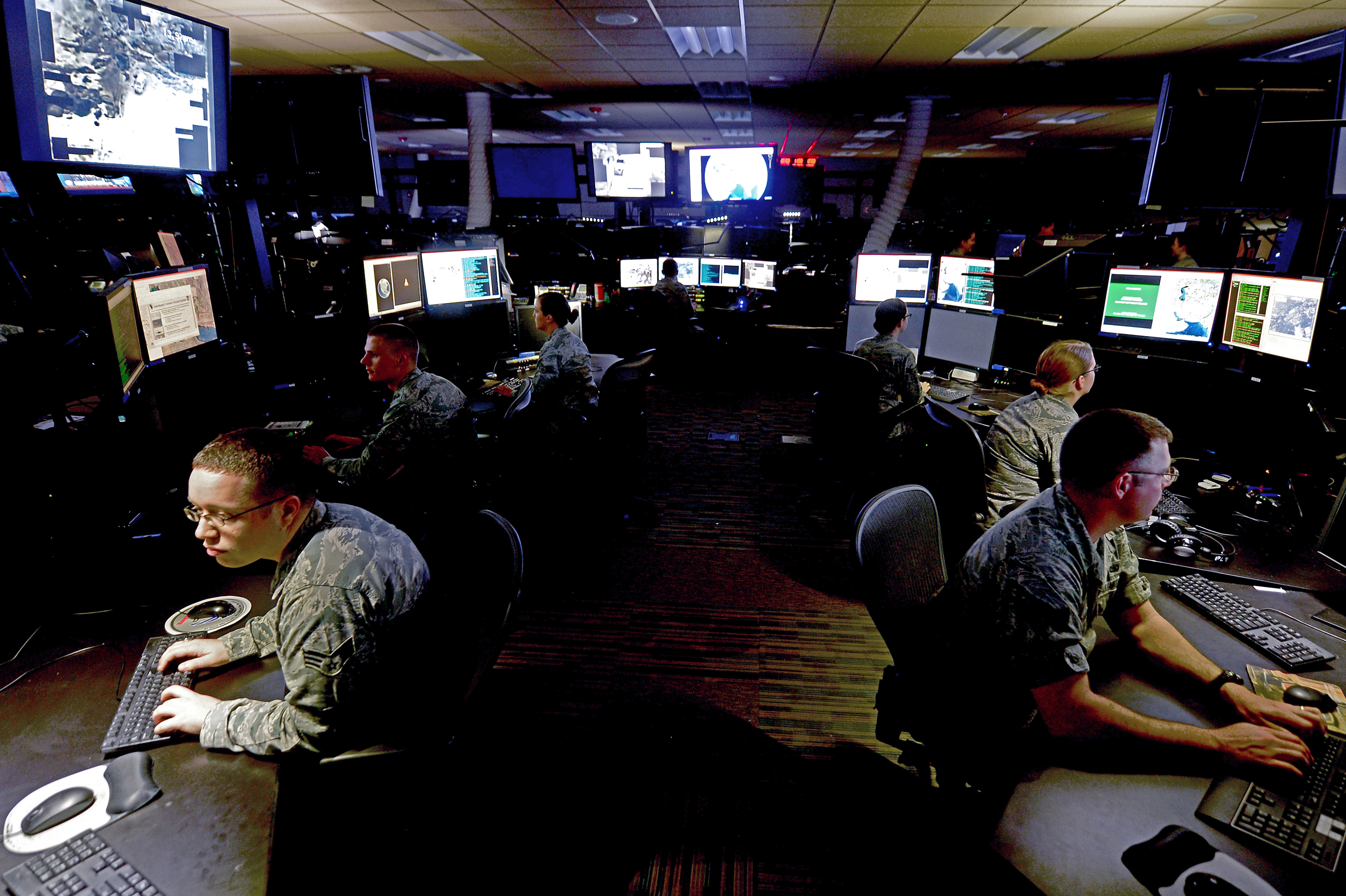

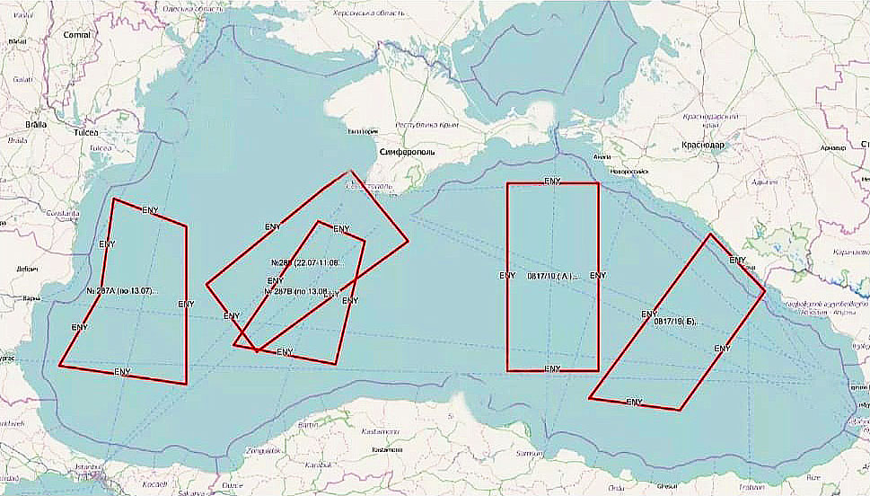
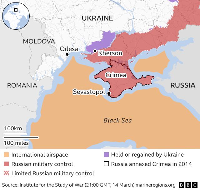


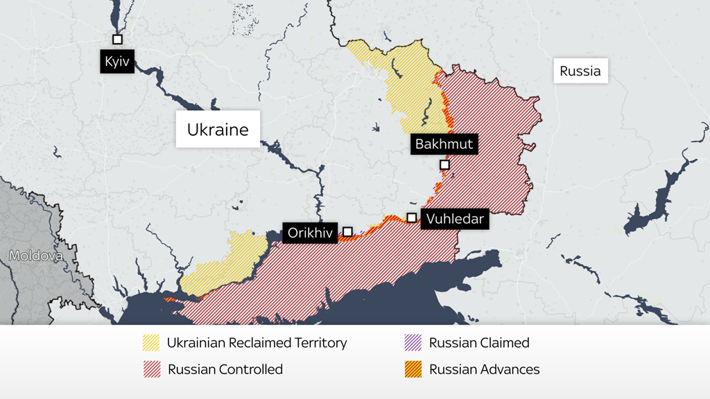
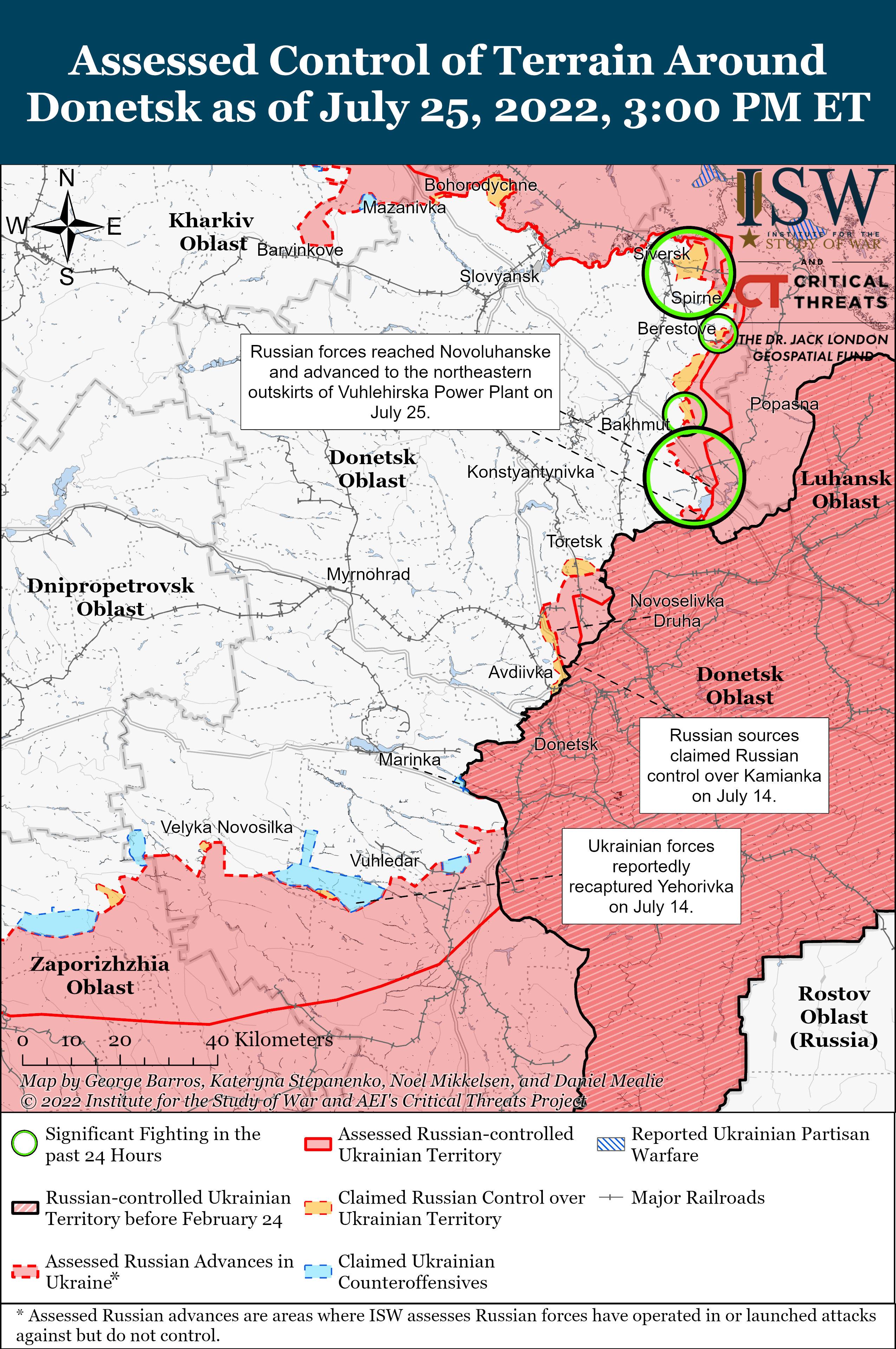


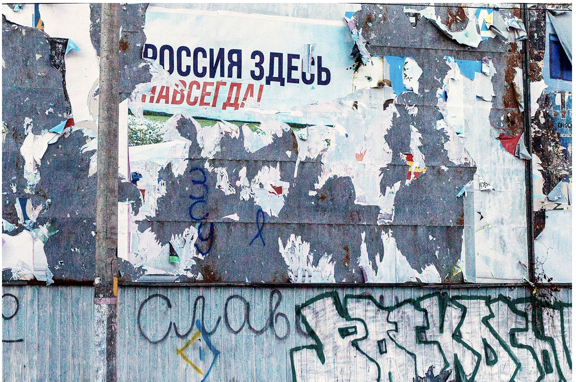
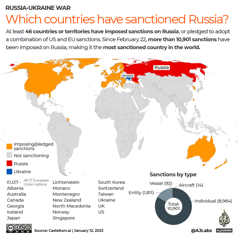


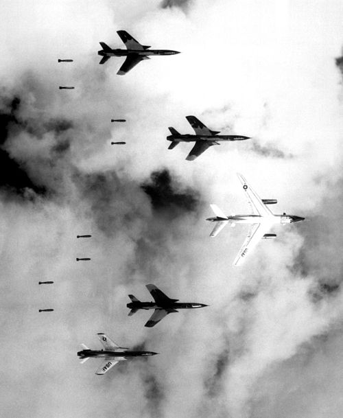


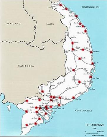
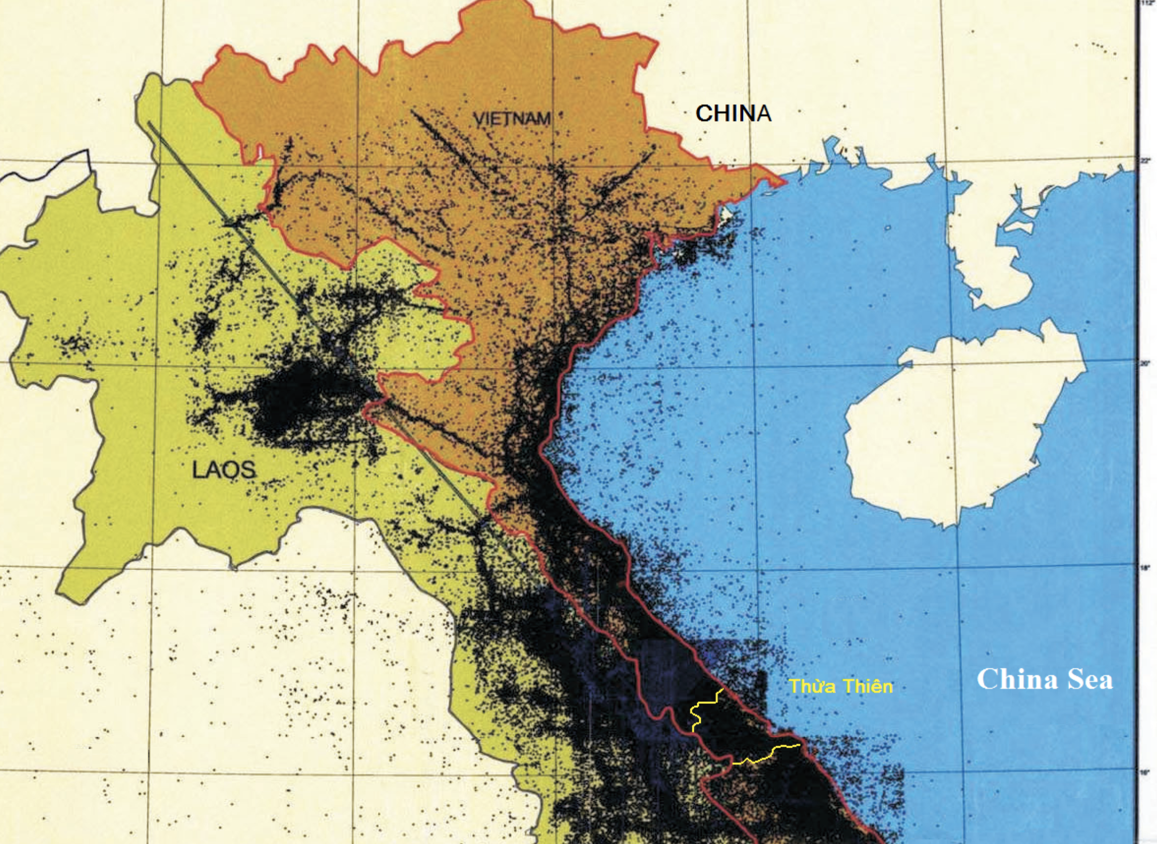
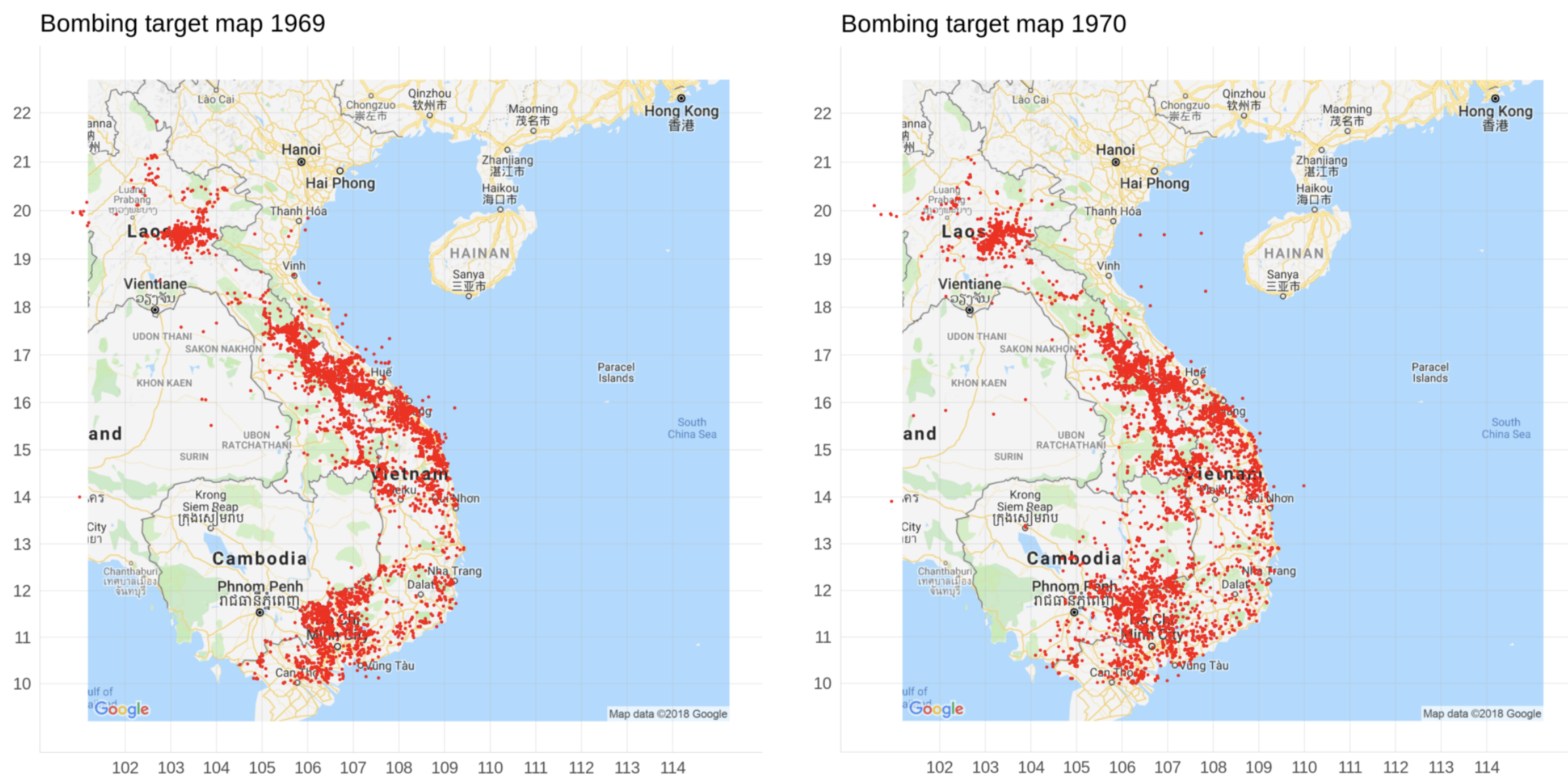

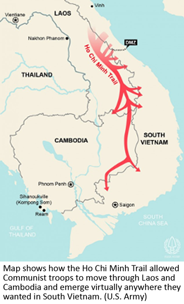
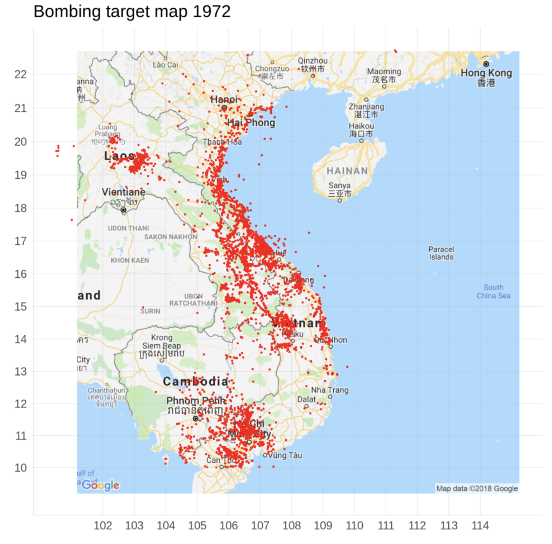
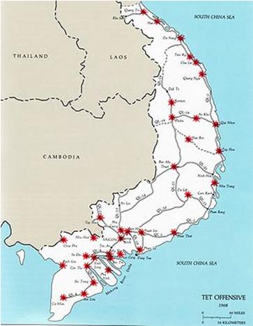
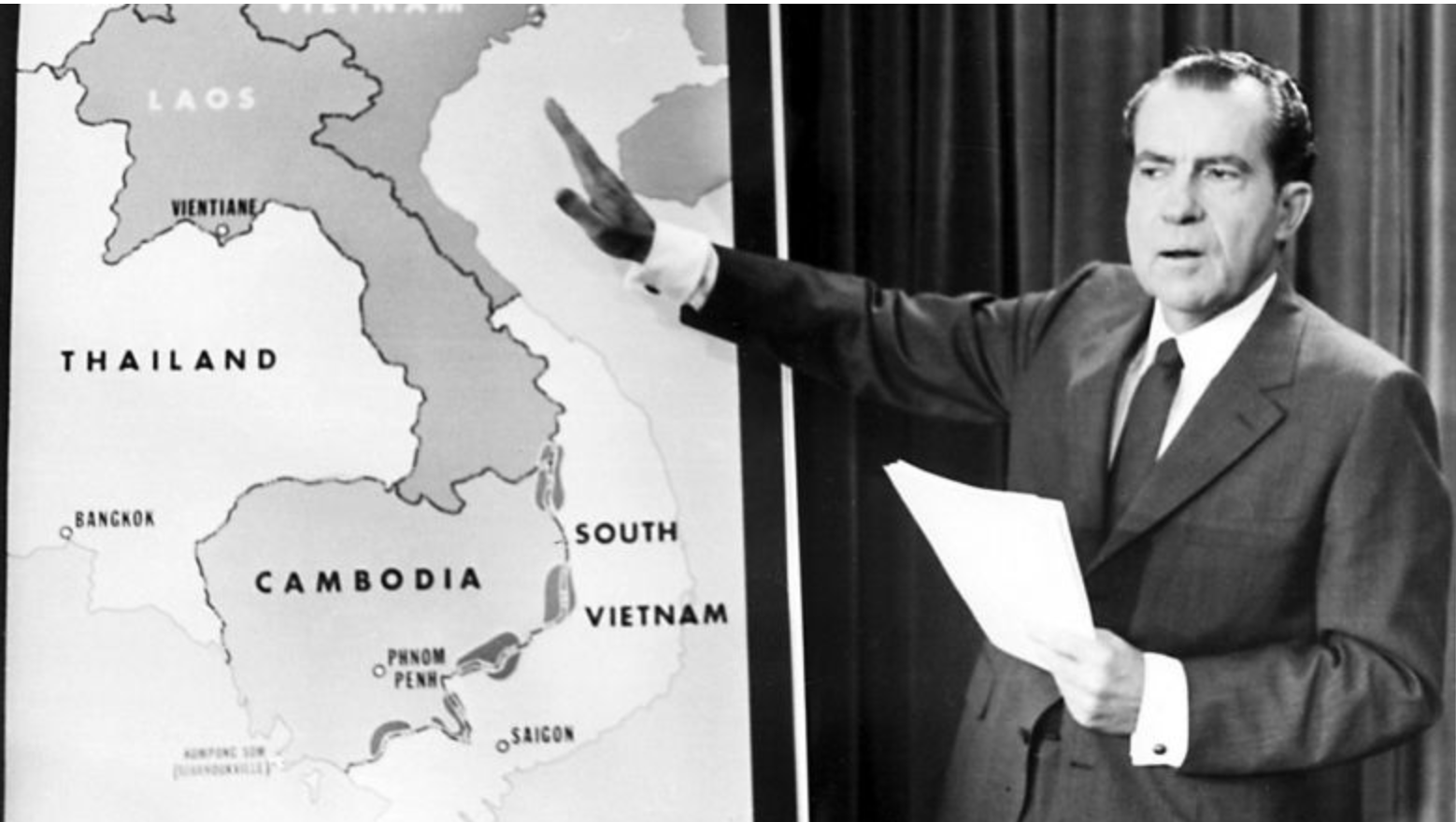

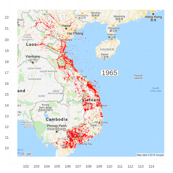
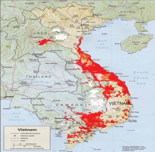
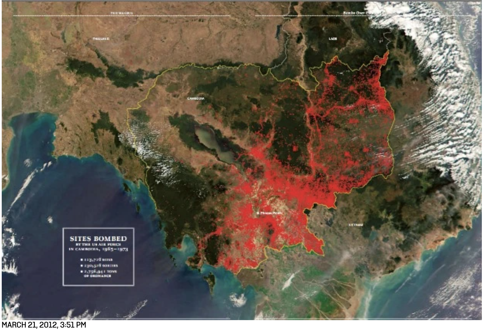


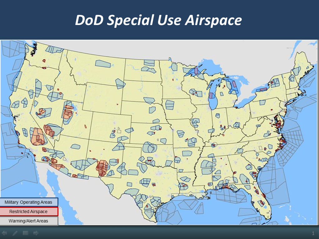
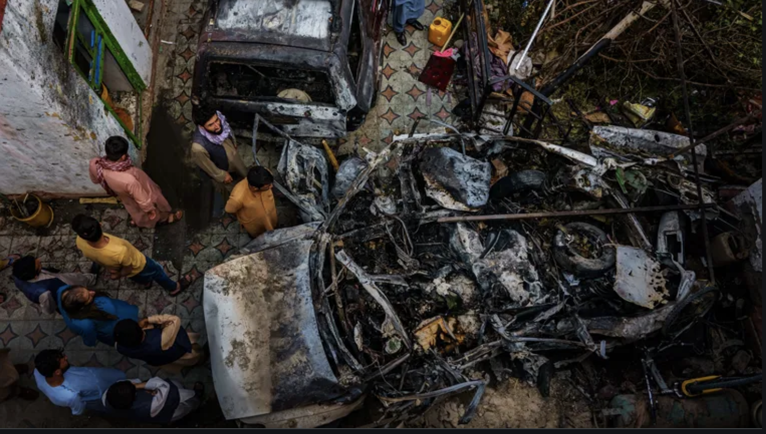
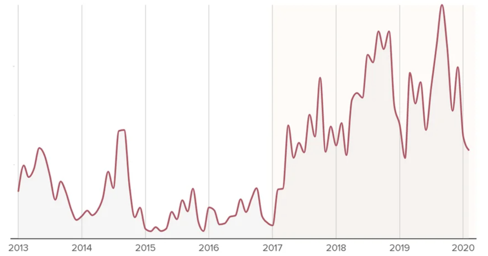
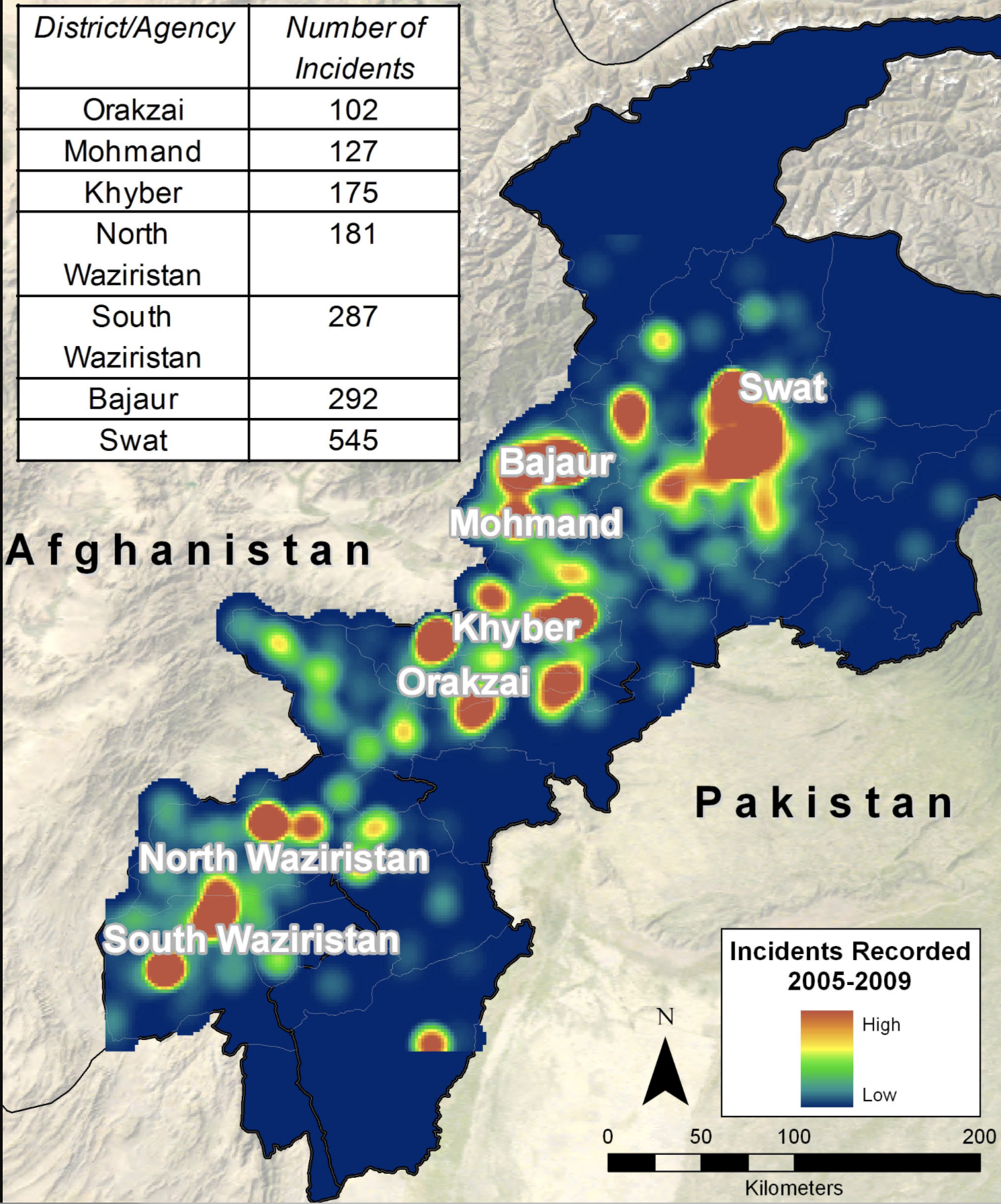
:quality(70)/cloudfront-us-east-1.images.arcpublishing.com/mco/QEFJZGYUGRBBPESJAHW3JU7O5M.png)


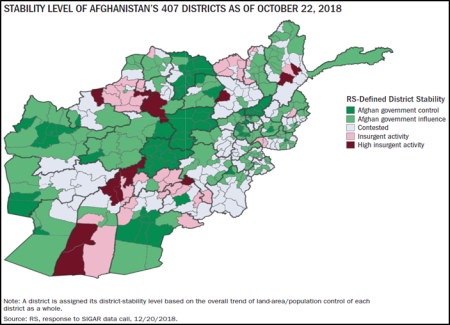


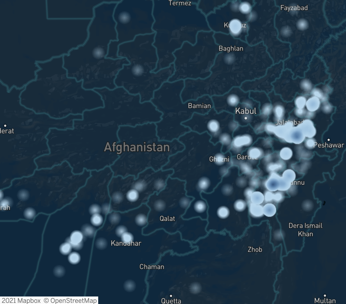

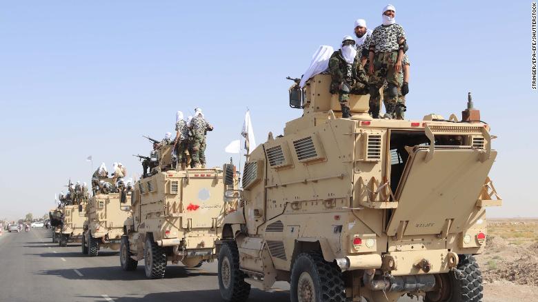


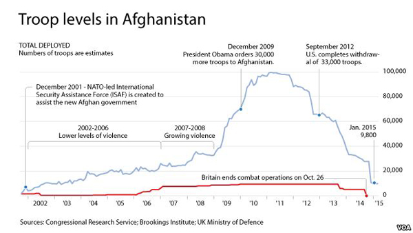
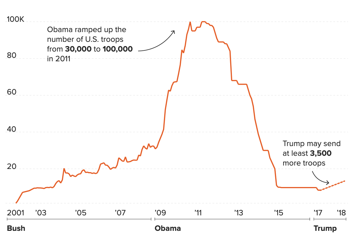
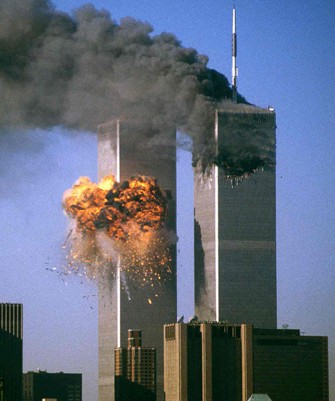


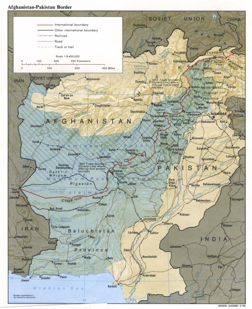

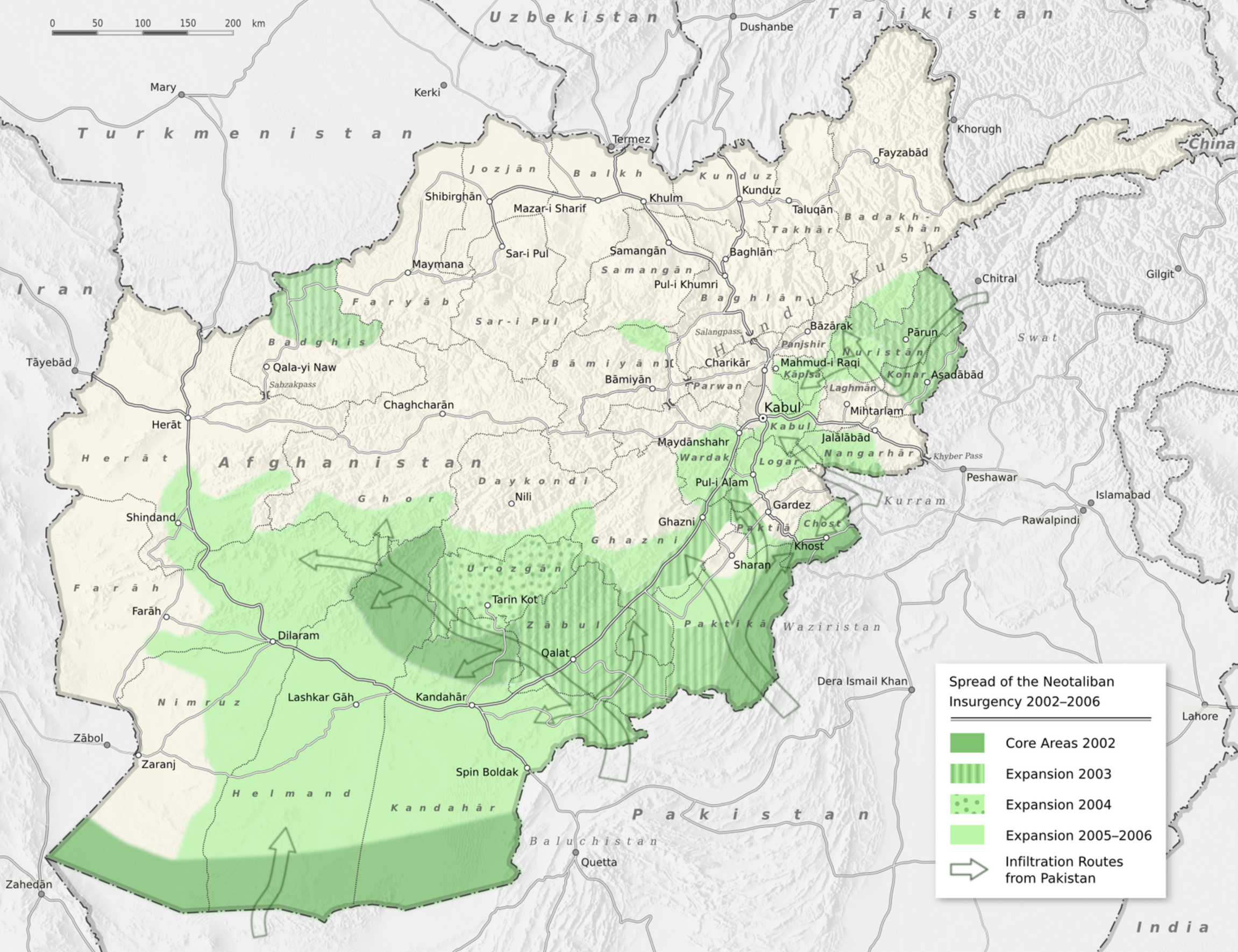

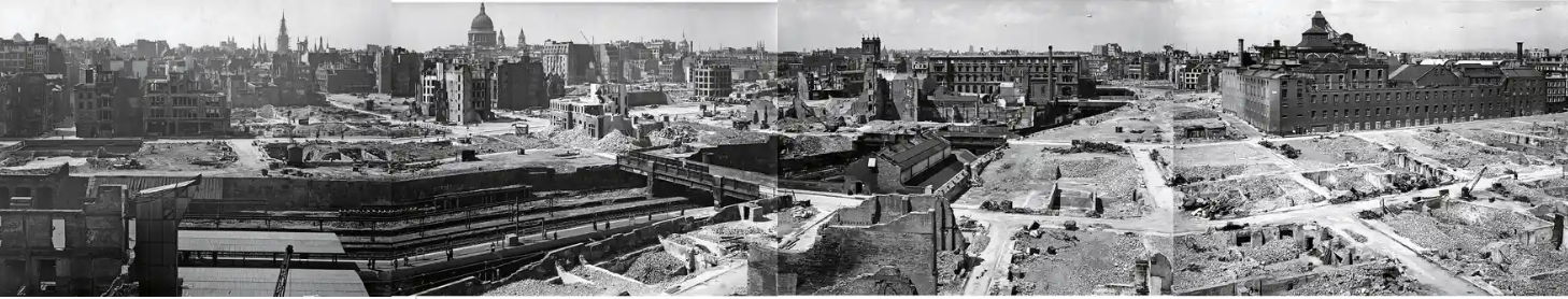


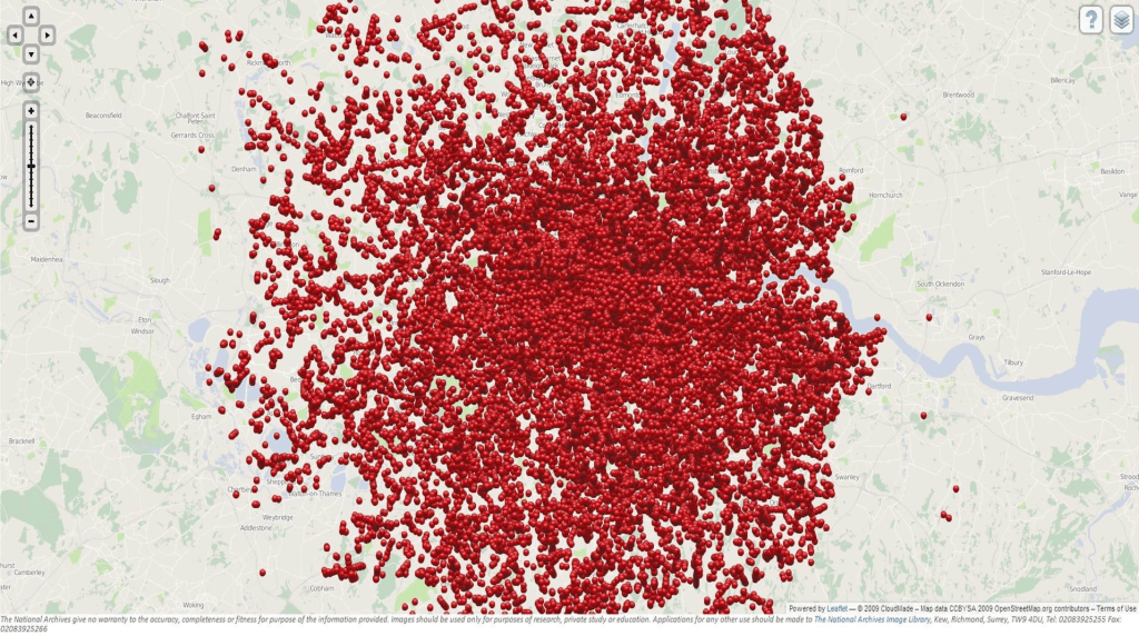


