The appeal that was exercised by a newly discovered set of gores that arrived at Christie’s announced was considerable. The map constituted one of the first mappings to show the place of America on the globe–and indeed to map the globe as a globe. The considerable attention that the gores slated to go to auction in mid-December attracted must have lain not only in their rarity, but the cult of priority of the naming of place. The gores exemplified the declarative role of mapping to designate place, as well as a geometric organization of global continuity shortly after the discovery of the new world, but it was hard to imagine that the appeal of the gores in our increasingly pixelated, pointillistic, and fragmented mediated sense of space was not in the solidity with which they seemed to embody “America,” both on the map and on a globe.
The gores were highly valued as the first image that mapped America–and assigned it a name–whose almost cultic prestige had grown allowed viewers view a watery western hemisphere, since described by antiquarians as the “birth certificate” of America, in an ahistorical but nineteenth-century fashion, for bestowing the name of the European navigator Vespucci on the continent that he had described in a set of letters that widely circulated in Europe from 1503, and provided a written account that oriented readers to to the New World, describing a vicarious sort of witnessing the unknown that expanded the demand for global maps as they were widely reprinted. Amerigo Vespucci described the long shorelines of a New World that allowed a distinctively modern way to view a rapidly expanded image of the inhabited world, and allowed Waldseemüller–even if the humanist cosmographer who had trained as a theologian rarely travelled beyond his town of St. Die, near Strasbourg, but exploited the printing press to reconcile Vespucci’s findings with precepts of map projection derived from cutting edge cartographic tools. And when he adopted the format of the mathematician Apian to render the world on gores, he used the graphic techniques of projection to lend solidity to the first narrations of the New World. So it was quite surprising that the forged copy of gores that almost made it to auction in 2017 belonged to the same visual culture of online images–the culture of image capture and digital reproductions–as what seemed a worm-eaten sheet of printed paper was found to be created by tools of digital photographic reproduction, with little human trace of an engraver’s hand, although they seemed strikingly similar to the long unknown image of a material rendering of the post-Colomban world.
 University Library of Munich, ULM Cim. 107#2. Courtesy of University Library of Munich
Indeed, the similarity between the online diffusion of the image and the reproduction of the fake seems a modern rewriting of the intense attention that Waldseemüller and his circle of geographers in St. Die embraced the tools of early modern engraving to design multiple woodcut maps in the first decades of the sixteenth century, in order to meet a fast-growing market for globes that lent legibility to the world. But the new forms of legibility that the online reproductions prized–so distinct from the printed images of the early sixteenth century–seem something like a moral fable of the different levels of spatial legibility of different ages, if not two period eyes. The gores that cosmographer Martin Waldseemüller and his St. Die circle had designed were printed in 1507 had been long prized as the earliest example of an identification of the New World as America, in honor of Vespucci. In an elegant description of the entire surface of an earth as yet not fully known, but able to be mapped in a woodblock form, the gores adopt and incorporate aspects of recent engraved maps and nautical charts in a synoptic visual digest. The gores form part of a distinctly cosmographic project of rendering the world on a graticule of parallels and meridians, and vaunting the adoption of an ancient global geometry for transposing the curvature of the inhabited surface of the globe to a sectional globe of two dimensions, despite their limited toponymy, and balance their comprehensive coverage with the treatment of the map as a canvas to advertise the new naming of America, expanding the map’s surface far beyond the manuscript tradition of Ptolemaic maps and orienting viewers to the predominantly watery surface of the world.
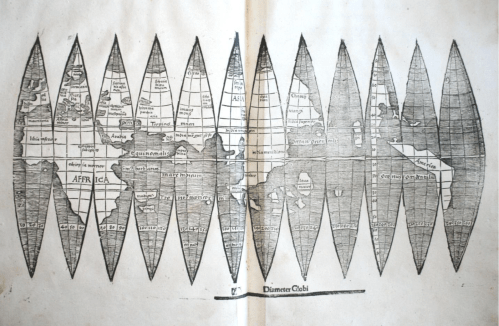
The single sheet that seemed early modern map gores for a short bit of time seemed to belong to the first records naming the continent after the navigator, and clearly gained their value as such as a piece of paper: the announcement of a new discovery of the sectional rendering of the world’s surface by regular intervals of thirty degrees appeared to offer an early geographic primer modernizing Ptoleamic geography, based on the first nautical charts of the new world. The attempt to chart global space for Renaissance readers who remained in Europe were long associated with the cosmographer Martin Waldseemüller, the mathematically-trained theologian and cartographer known for creating several global maps, and for writing one of the first treatises of cosmography to adopt Ptolemaic principles to explain and describe the principles for mapping the New World. By announcing the adoption of a new set of tools as a new descriptive framework in a manner similar to his 1507 cosmographic wall-map, which unified the nautical charts of America Vespucci with a Ptolemaic framework of world-mapping; the sheet of map gores supersede traditional nautical charts in a form of world-making.
Indeed, the single sheet seemed to seek to promote universal geometric tools to unify an expanded global expanse: the new sense of the “cumene” would not be recognized by Ptolemy or ancient mappers, and gave an expansive portion of its surface to oceanic expanse, registering a new conception of a terraqueous world. The graphic image following Ptolemaic principles of projection incorporated Vespucci’s accounts and nautical maps in a new model of cosmographic knowledge, inviting readers to experience vicariously his travels to the New World, and to understand the greater value that he attributed to maps and cosmographical knowledge to arrive at this site across the ocean in another world: much as Carlos Fuentes has recently offered an indelible picture of the epistemic paralysis of the monarch Don Felipe, a barely disguised version of Philip II, as a semi- autistic ruler doubting the existence of a new world that was not comprehended in the palace to which he has withdrawn in Terra Nostra (1975), a massive novel whose literary structure mirrored the tripartite structure of the palace Philip II commissioned to include maps of all the Spanish possessions, the embodiment of the globe on a set of twelve elegant map gores would condense and rebut such the imperial stance of utter disregard to the new world that possessed Fuentes in his novel. The careful construction of the globe’s surface onto indices offer a global purview that might be called the first age of globalism.
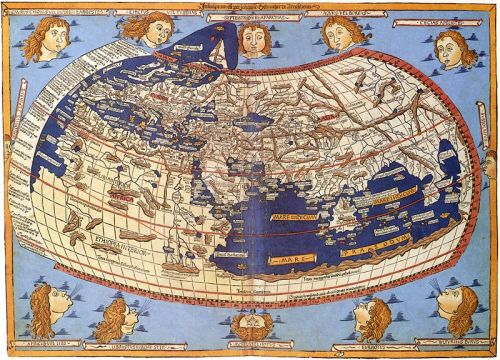
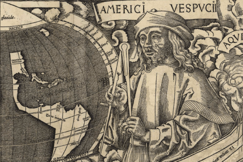
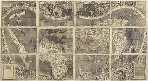
1. Waldseemüller’s single sheet map condensed the cosmographic principles the he had followed in series of elegant wall-maps that foregrounded the artifice and difficulty of the composition of the world map. Waldseemüller and his circle had actively promoted standards of global legibility, using Ptolemaic precepts in a triumphal manner to celebrate the power of naming, charting, and mapping new lands for European audiences that invited ways of telling, describing and narrating Europeans’ spatial relation to a new world. The large wall-maps that he produced in over a thousand copies promoted modes of reading globalist relations facilitated by copious textual cartouches and inventive decoration, that underscore its cosmographical nature as a product of writing, drawing, and design to affirm the growth of oceanic expanse that defined the continents. The wall map was hardly free of what Edward Tufte might call “chart junk” on its exuberant margins, but conveyed tthe excitement of heralding a new graphic synthesis of a global map over which Vespucci presided in one lunette, adding continents of a new hemisphere to the known globe, offered a cartographic solution to a problem of ordering terrestrial space.
 Martin Waldseemüller, Universalis Cosmographia secundum Ptolomei Traditionem . . . . / Library of Congress
The image is no less than celebration of the new status of cosmographical arts that elevate the medium of engraved images to tools of global description. If the twelve-sheet c wall maps Waldseemüller’s school composed, designed, and whose engraving they closely supervised set a new standard for the elevation of cartographical skill from a technical craft to a new model of knowing and seeing–and a way of making epistemological claims, as much as using transmitted forms, in ways that linked the art of mapping as a scribal technology to cultures of telling, describing, and demonstration, the wall maps invite viewer’s eyes to comprehend space outside a situated position.
 Martin Waldseemüller, Universalis Cosmographia secundum Ptolomei Traditionem . . . . / Library of Congress
In a counterpart to the large wall maps that he designed and sold, Waldseemüller expounded the modern precepts to orient one in space and synthesize global knowledge by parallels and meridians in his Introduction to Cosmography (1507). The slim volume, the basis for his identification with the unsigned gores, seven as a manifesto for the twelve-sheet engraved global wall map, over which preside busts of Ptolemy, the ancient geographer who formulated the mathematical precepts of terrestrial projection on a graticule, with America Vespucci, combined the modern experience of navigation with the ancient precepts of learning and naming place. Waldseemüller himself never travelled far beyond his native Strasbourg, but invested the map with authority to communicate geographical knowledge as a token of modernity of embodying a global geographical knowledge, albeit a modernity now displaced by the grid. Waldsemüller’s projection has the energetic displacement of the authority of a nautical chart, echoing how Vespucci declared his competency in his letter to arrive at the New World even “without the knowledge of sea charts” prized by navigators, being “more expert in navigation than all the pilots of the world.” The gores staked a similar model of expertise of reckoning and calculating distance and place by a new matrix of latitude and longitude that they embody: the preeminence of the graticule as an epistemological tools of global geography that expanded the scope and nature of geographical knowledge lasted some four hundred and eighty years until it being displaced by grids. Indeed, the value that the map was readily assigned suggests its survival in a distinctly post-scribal culture of mapping.
Did the value that the auctioneers assigned the map gores reflect these grandiose knowledge claims? The gores elegantly translated knowledge of the earth’s newly discovered hemisphere to indices the viewer could readily process and digest, foregrounding the new name that it proposed for the continent named after the Italian navigator. But they assumed a new status in the age of digitized maps, and Google Earth images of global interconnectivity, which may have been paradoxically elevated by the newly antiquated image they acquired. Rather than being sold as emblems of knowledge, the new image of the gores that Christie’s claimed to bring to public auction had gained an immeasurable status after the earlier auctioning of similar gores for above a million dollars, not to mention the unprecedented price that the United States Library of Congress agreed to pay in 2003 of $10 million for the sole surviving edition of the large wall map Waldseemüller had engraved, the one copy of the thousand-odd he had printed, of which it was something of the poorer cousin, but which had been widely touted as the “birth certificate” of America, and the map on which Waldseemüller had proposed using the name of the Florentine navigator Vespucci who had described the long coastlines of the New World in his printed letters.
The set of map gores, a complementary spherical map that Waldseemüller had described making, provided an early image of global totality that gave a similar dominance to the line–indeed, the geometrically determined line–to orient viewers to a global surface. When the late historians of cartography David Woodward and J.B. Harley tersely defined the map in “purposely broad” terms, at the outset of the monumental History of Cartography, an extremely elegant series since expanded over multiple volumes, as “graphic representations that facilitate spatial understanding of the world of things, concepts, conditions, processes, or events in the human world,” they may have been thinking of the graphic lines of the gores as such a facilitation of spatial understanding. For the gores process the encounter with the New world, the travels of the navigator, and the recovery of Ptolemaic precepts of world-mapping, and the naming of the newly discovered continents in the western hemisphere on a clearly graphic construction. Woodward and Harley’s emphasis on “graphic representations” recuperated the ancient Claudius Ptolemy’s use the Greek verb γράφειν (graphein), or “to write,” and Waldseemüller’s assimilation of that verb of the act of writing to engraving tools; it caused much revision, even by Woodward himself, of its lack of allowance for cross-cultural comparisons, but suggests a significance of writing systems as a mode of ordering space. Waldseemüller appropriated the authority of the verb in print, giving the engraved line a deictic sense of displaying space–
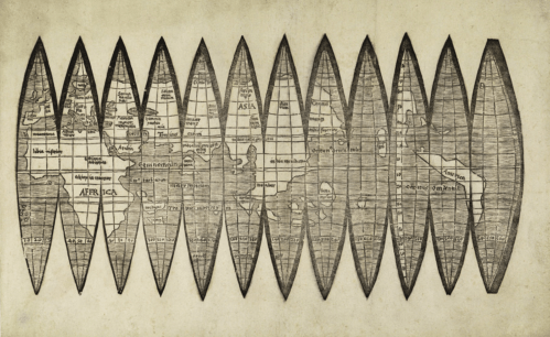
Waldseemüller School, 1507 Globe Gores/Badische Landesbibliothek
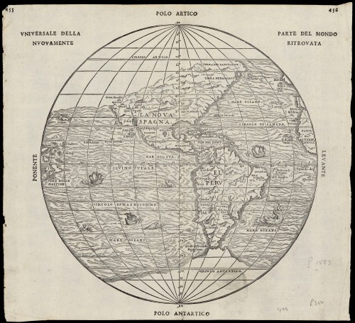
–in a map of globular design of the sort that Woodward idealized as the culmination and embodiment of cartographical principles, in a globular map of the sort that was more readily defined in a more familiar globular form by 1583, here shown in two images of the same year in “universal rendering of the newly discovered parts of the world,” printed in Italian, or discovered parts of the world, which emphasize nautical travel as the basis for the incorporation of place on the globe, and reveal the increased scope of geographical exploration in the intervening eighty years.
More broadly, however, “graphein” might be understood as the trace of the human that orients themselves to the world, hand-drawn or manually rendered. These were soon shown to be absent from the gores: indeed, the blurring of the very lines of the gores that went to auction suggest that they belong to a new visual culture of scanned images and photographic reproduction. The very traces of graphical operations were permuted and erased in new ways, as is the sense of a human presence, in ways that suggest the distance of our own visual culture from Waldseemüller’s world, in ways that the forger never intended.
In their groundbreaking History of Cartography, David Woodward and Brian Harley had celebrated the line as the means of graphical orientation, in what now seems an elegy to the art of printing. An unforgettable image remains clear in my head of David Woodward in his basement, in Madison, WI, running maps off a letterpress printer, and hanging them to dry on strings by clothespins, and his love of the ink applied to the engraved plate to present a precise rendering of space. But the fake set of gores that reached auction were not printed or drawn, let alone in the Renaissance or during Waldseemüller’s life, but probably printed some five hundred years later, from a scan of the map in the James Ford Bell Library’s website.
The gores that arrived at auction this December suggest far less of a clear trace of a human hand, and perhaps belong to a different visual culture of online images. Indeed, the astronomical value that the single sheet was invested may be a symptom of our entrance into a different visual culture of mapping–indeed, the sheet that seemed to be valued at more than a sheet of gold of the same size suggests the fetishization of the paper map in an era of web-based mapping, and mobile GPS. The fake gores suggestedthe translation of Ptolemaic terms to a visual culture that privileges the dot and the grid as a basis for orientation, rather than the engraved line, but where the aura of the writing of space persists, and the paper map fetishized in a world that increasingly relies exclusively on mediated digitized images. The set o fraudulent gores is itself something of a post-modern artifact,–less concerned with the authorities of narratives of discovery, but able to admit the false authority of the map as objective, and almost ready to accept the value of its aura even if it was only an image grab printed on old paper.