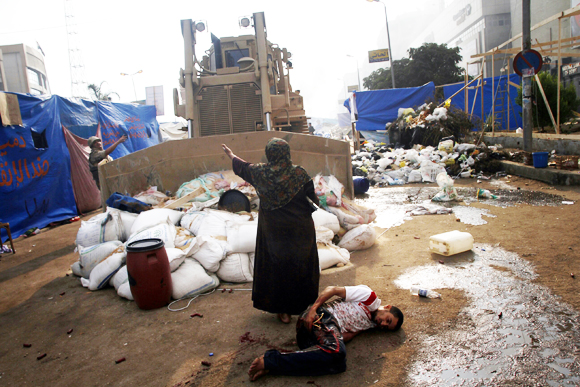
With an overwhelming display of strength usually reserved for clearing Palestinian settlers from villages in the Sinai or Gaza, Egyptian police forces descended at 7 a.m. on the sit-in at Nasr Villages’s Raba’a al Adawiya Square, near to the Raba’a al Adawiya mosque in Nasr City; indoor viewers watched non-stop footage on their television sets. Attempts to map the site have been oddly silent about the crackdown as an erasure of both a physical site of congregation and a symbolic site of open congregation, whose symbolism was tied not only to the mosque but to its autonomy–and less clear on how the symbolic connotations of the site mapped onto its destruction, for all the photos of both carnage and charred remains.
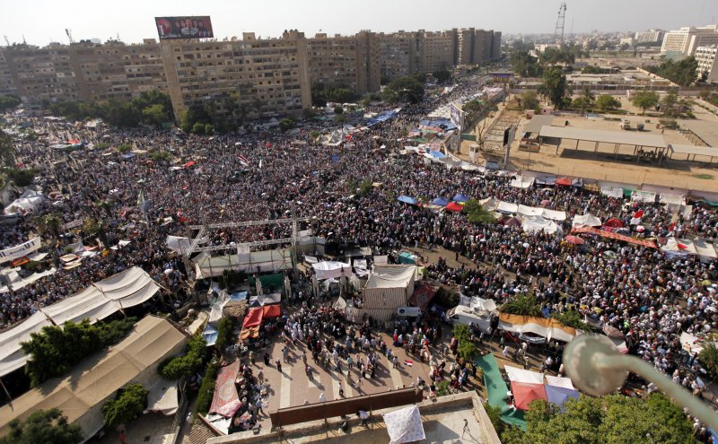
The demonstrations had been themselves some sort of micro-city, a testament to the organizational abilities of the Muslim Brotherhood, with entrances, checkpoints, and security committees. Other sites to register protest emerged, but were more easily cleared because, unlike the Raba’a Square, they were far less open or established, and less clearly defensible, leaving the two largest sites of demonstration at the university in downtown Cairo and at the mosque; protesters congregated at the mosque from June 28, or before the Constitution was suspended on July 3, which became the epicenter of protest; after government demands to end sit-ins August 11, the Raba’a sit-in dramatically grew.
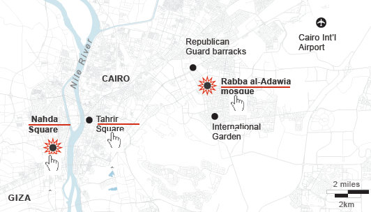
The site of the “camp” itself, however, six miles in proximity to Tahrir square on an intersection of two-way streets beside a mosque, occupied a substantial chunk of civic space:

There was an initial attempt to map the “Morsi Sit-In” on the Al Jazeera network, as if to reaffirm its size. But the template of Google Maps can hardly come to terms with the mini-city created by the organization of entrances and check-points around the mosque, let alone the violent nature of the eradication of protestors–steamrolling the place, dispersing protestors by fire and tear gas canisters, and violating the site of the mosque. The occupation grew around the traffic hub of El-Nasr road, around the hub or nerve-site of the mosque itself, that convey its breadth and “infrastructure” as a movement. The map’s red dots of settlements are densest around the mosque, and define the ring around the neighborhood that had been surrounded with entry points before the order was given for army soldiers and police to move in, firing tear gas canisters to disperse the crowd and advancing into the square, where fires burned as police reportedly arrested more Muslim Brotherhood leaders as well as protesters who occupied the square, and entered the mosque itself: encampments burnt, the barricades surrounding the mosque destroyed, officers fired live ammunition as well as rubber bullets on retreating demonstrators, and protestors burnt tires around the last space the Islamic Brotherhood held in Cairo.


But the intersection of El Nasr Road in Rabaa al Adawiya functioned as a vital and living site in ways difficult to map without bodies.

The entrance of armored bulldozers on August 14 seems to have intentionally obliterated any trace of the occupation of the square, where settlements had sizeably increased from August 11, killing upwards of upwards of 623 and wounding thousands. Since vouching two months ago to protect Mohammed Morsi’s presidency “with soul and blood,” the protestors in Nasr City equated their occupation of the Cairo square with the occupation of Tahrir Square, a site earlier filled with anti-Morsi protestors, but the initial site of and platform for anti-Mubarak protests: Morsi supporters by the mosque promised sought to rest the voice from those in Tahrir who had called on him to leave in late June. The protestors who have settled in the square have created a sort of miniature city, much as Tahrir Square had been, as a public space, complete with tents, lavatories, improvised kitchens, and even dormitories, giving it a clearly contestatory role in the city’s geography–now cleared of inhabitants, save improvised clinics, hospitals, and improvised morgues. If Tahrir provided a sort of voice of the nation that call for Mubarrak’s resignation, and later for the end of the Morsi government, Raba’a seems something like a counter-voice of public debate: the occupiers refused to leave until those at Tahrir disbanded. While the al Adawiya mosque had been a site of site of assembly and congregation of the dissolved Shura Council–planning to convene its opening session from July 21, a site of a shadow government of Islam from July 21, in response to the disbanding of the Shura as a legal body. (Although press coverage has focussed on the mosque, it has ignored the dual function of the mosque as an alternate site of governance.) The mosque is now in ruins; the Al-Imam mosque also in Nasr City an impromptu morgue.
The territory around the mosque and the building was a focus of military aggression by Egyptian troops, as if the site of meeting needed to be obliterated from cultural memory. The response to the sit-in in Raba’a reveals it to be as politicized a territory defined by streets as the Parisian barricades, where every inch was contested. The government’s prime charge was ostensibly that they had come to obstruct traffic at a busy intersection in Cairo, and obstructions had to be cleared from the site. But the mass arrest of protestors and the violence of the response to clear the square, evident in the below photographs, suggest that a decision to obliterate any sign of their presence was the symbolic capital of Muslims in the city. The notion of obstructions to traffic was not only a pretense, but a metaphor for how the Generals felt about the protest.
Indeed, to feign to hear to other voice within the demands than a traffic obstruction is belied by the extent of any material remains of the tents, houses, and dormitories that existed there, as if to erase them from a historical record as well as to preserve their control over a divided urban space.

 Mohammed Abdel Moneim/AFP/Getty
 Detention of demonstrators near Raba’a al-Adawiya mosque. AFP/STR/Getty
 AP/Ahmed Gomaa
Was the site of the mosque the target of such destruction? And after the fires at the Square, the mosque itself was burned, its sides were charred by smoke and interior demolished, as if to destroy the symbolic center of the protest itself that had provided shelter and refuge for debate from June: after armed forces dispersed attempted to continue the sit-in in Moustafa Mahmoud Square in Giza, subsequently to the dispersal in Raba’a, protests marches have been organized in response from some thirty Giza and Cairo mosques to Ramses Square.
 REUTERS/Mohamed Abd El Ghany

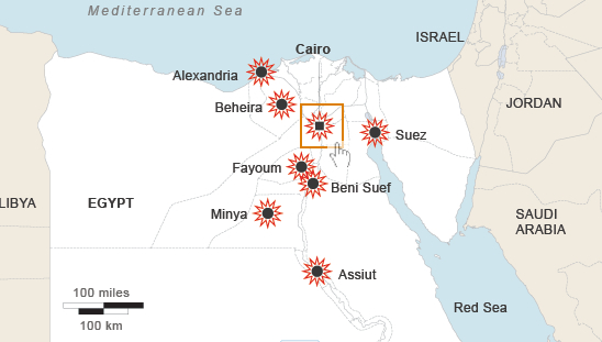
As violence spread into other neighborhoods in Cairo and to cities throughout the country, with churches and government buildings desecrated or destroyed, Egypt’s government declared a thirty-day state of emergency, and a curfew. The next day, the deployment of armored vehicles around Tahrir Square the next day seemed designed to prevent the capture of another stage of public visibility. Soldiers also stand guard over the ruins of the mosque where the protests began.
 Bryan Denton for The New York Times
The square in Raba’a was filled with crowds from early July, according to Business Insider:
The site of the mosque and the center of the protest is now being swept clean, the crowds long scattered and dispersed. The violence has spread to other neighborhoods and cities that might not be able to be clearly mapped, after troops violated the significance and integrity of the square.
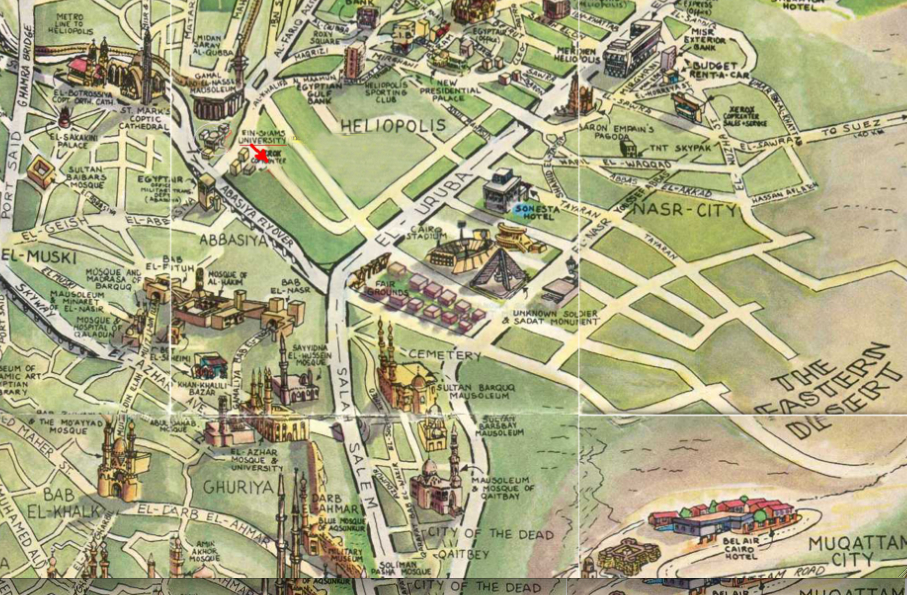
One might remember that a very different, if antiquated, image of the integration of mosques within the skyline of Nasr City, Heliopolis, and the surrounding neighborhood: