Category Archives: newsmaps

The Map is Dead–Long Live the Map!

Participants at the symposium Mapping and Its Discontents debated the benefits of the near-ubiquity of uniform mapping systems sponsored and orchestrated by Google in our lives.  Many of the wonderful papers tried to suggest the benefits that mapping served as alternate ways of making visible the unseen and giving voice to the silenced–but did so with deep skepticism of the dominance of Google Map’s blandly undifferentiated surface, both as a sort of collective erasure of knowledge, and a sinister synthesis of gathering meaning about individuals’ consumption habits.  In this somewhat hopeful symposium, whose speakers urged the audience to go forth and map, Denis Wood offered a skeptical history of mapping as a form of art, focussing less on its craft than on the contexts in which it was read and exchanged–and the historical “explosions” of map making as a tool of state-making.

Although Scott McCloud does trace comics back through cave paintings and the Bayeux tapestry, something we recognize as a comic book it to printing and mass-production of paper in the mid-nineteenth century, the printed ephemera Alan Aldridge and George Perry first identified as antecedents to  the sort of fantastic album art he produced, we don’t see much we would recognize as a map until printing, Wood argues–and that the fifteenth century is a good place to start the history of maps.  But rather than peg the map to the material practices of the production of information, the ways of embodying information and need to embody networks of spatial organization reflect the new need of an emerging modern nation-state–as well, he might add, though he omitted it yesterday, the need to straighten out clear bounds of contact and digest the discovery of new worlds.  (One might object that rather than leave this entity of the “state” so monolithic, dual origins of causation can be seen in the Renaissance, both as a period of contact with new worlds and that gave currency to the creation of newly imagined worlds–the “other Green world” of Harry Berger–as joint ground in the poetics of making, reading, and reproducing the map.)

As longtime interrogator of the power of maps and enfant terrible of the cartographical establishment, Wood’s opening salvo called attention to how print helped differentiate the standardization of shared practice of mapping space from the genealogy, charter, systems of notation, almanacs, calendars, or rolls, maps served to conjure the state to existence in its graphic performance–and to conjure the state, in ways repeated in histories of Japan, Siam, and the United States, as Elizabeth Berry, Thongchai Winichakul, and Martin Bruckner have shown, as a natural object, when it was not before.  Any attempt to naturalize the map either as a depiction of the world’s surface or universalize its documentary function, he noted, including the celebration of the recent democratization of mapping skills that seem to dislodge authority from the map’s form, passes over the map’s role in the state and state formation as a form of spatial intelligence and spatial intelligibility.

We might do well to look for origins, Wood proffered, by asking exactly when it became a slur on a civilization that it does not use maps–or couldn’t read them.  The question was enticing because of how it raised questions of the ties of map making less as an instrumental tool of dominance over space, than a standard of civilization and knowledge–a standard of the sort that Graham Greene evoked in his postwar visit to Liberia, Journey without Maps (1949).  Although Greene’s visit to the colonial outpost was certainly a product of Africa’s partial colonization by European industry, and the end of English empire, his account reflects Wood’s point that maps exists only where social relations call for them exist:  that where talk serves, maps are rare; but that when talk becomes inadequate, alternative graphic forms of communications develop within the state–of which the map plays a central role.  Greene beautifully if parsimoniously evoked the elderly toothless man with whom he shared a boat ride at the end of his 1946 journey who suddenly approached him with a piece of pressing news:  “‘Do you know that in Monrovia they have a map of the whole of Liberia?  I’m going there to see it.  It is in the possession of a family called Anderson.  They have had it for years,'” he says wonderingly, suggesting amazement at the foreign family of colonizers who possess a map of the entire country in which he lives.  “‘Sinoe is marked on it,'” he continues, “‘and Grand Bassa and Cape Palmas,'” repeating what he has been told by others, but never having seen a map of his entire land.  The encounter might well have been invented by Greene, but created a topos for the encounter between the map-literate and native that presumed an eagerness for encountering a map–the map seems a sort of lodestone–that might be either a western fantasy or a deeper discovery of a land where, absent the myth of colonial organization, the residents don’t know maps, or an illustration of deep ties of mapping to the civilizing process delineated by Norbert Elias.

Printing allowed the map to penetrate the lives of people about 1500, unlike other forms of data-keeping:  for the creation of a map that penetrated the lives of ordinary people and readers effectively under-wrote social relations of power in very concrete, linking territory to other things in ways that advanced the making of maps and shifted the role of mapping as an enterprise:  we count only a few thousand maps prior the growth of the nation, but an explosion of the production of maps in the sixteenth and seventeenth century occurred of the sorts of which was never known, and parallels the map’s entry into individuals’ lives to a degree that never occurred earlier–a notion, as Wood long ago argued, of “map-literacy.”

Nations were indisputably the new arenas of this move to mapping, unlike the printed maps that were widely sold in Italian city-states or the Netherlands.  Earlier maps such as cosmological charts, star maps, or property charts of the Babylonian period or in Japan and England had legal purposes, but quite different from large-scale graphic property function in varied places around the world, and without participating in a map-making tradition in projects such as the mapping efforts of Phillip II to create detailed records of imperial possessions in the Mediterranean, or the huge map making projects of Louis XIV and Colbert that are tied directly to the state and to the material recreation of state sovereignty.  (Of course, this raises the question as to why maps first emerged as forms for advancing epistemic claims and embodying places in areas that were less clear as examples of the modern state, like Italian city-states or sites without empires like the Netherlands or whether the imaginative ends of mapping can be separated from their administrative ends.  Wood sees them as being as tightly tied as the sides of the same Moebius strip.)

It is in this arena of the state, Wood forcefully argued, that we can see the inauguration of modern topographical functions from real estate, to prisons, to cellphone use, to voting practices, to states rights, to a point at which we can’t consider life without maps.  The date 1500, far from being one of convenience, is something like a benchmark or velocity point for the new roles that maps began to play and that they continued to assume today–a point of no return, as it were, of the sort Ian Hacking drew to mark the emergence of probability at the date 1660.  Only after 1500, or in later periods, did mapping emerge as a way of life, Wood insisted:  if some fourteenth-century monks drew plans of their monastery, the idea was not widely or even narrowly pursued as a basis for collating evidence, or followed up on in ways that reflect the multiple functions maps came to assume.  There is a bit of utopianism here:  whereas human societies didn’t need maps, and got on well without them before 1200, he argued, noting rights and properties’ specific attributes in other ways,  the map’s discourse-function failed to develop itself as a means to exploit strategic resources and to have operable use and currency.  While he recognized the evidence of the creation of maps in Song-era China within select parts of well-established bureaucracies, only later did maps gain a large discourse-function of operability.   This may be a bit of a slippery logic, but argues that the “map” had new meaning at a certain point as an object of exchange, and that no properties inherent to its design exist save as such an object of exchange.  So much for its formal attributes.

Wood marked the birth of the map that is now perhaps dead  at this sort of a watershed:  in 1400, few used maps; by 1600, maps became inseparable from social functions in a global context that is itself only beginning to be mapped.  The abundance of eighteenth-century maps in China, or in the seventeenth century in Japan, and in Vietnam from the 15th and 16th century, and Mesoamerican and Malay maps in 16th century, are traditions that inaugurated in the early modern state.  Indeed, there is a weight of evidence to shift this change in the growth of European knowledge, and it reflects a massive rise of needs for map making to ensure border control, water management, land reclamation, military needs that just exploded with the state.  If even in Florence, Italy few maps exist from before 1565, Florentine, Neapolitan and Milanese mapping projects all exploded in the sixteenth and seventeenth centuries, as they did in seventeenth century Japan, when thousands of government maps issue in Japan, and maps served to perform the form of statehood.  

What changed, Wood argues,  was that then new political structure of impersonal construction demanded new forms for its embodiment, and gained a propositional function that was absent from earlier map making traditions–a propositional function that was necessitated and called into creation by the state.  He recalled how Martin Bruckner showed how the image of the national map of the United States staked the proposition that there could be a tenable unity among this expansive nation, much as imperial maps of Britain tried to persuade readers on both sides of continent of imperial possession of north american content, as an artifact of state–both of these cases illustrate the new tangibility that the map assumed as a means of calling the expansive relation of the state into existence by the graphic performance of statehood that was newly enacted in the printed map, and which the map served to make legible.  As Thongchai has shown in his work on Siam, maps served to produce the very “geobodies” that become totemic through the map’s presentation of the state, creating a sense of unity not familiar to many, but able to normatize a nascent polity, and to instruct countless participants in the construction of our country–even without a clear idea of citizenship.  The skill of state apparatus lay in bringing routine of state practices to a larger audience, as Valerie Kivelson argues in Russia, down to a lower level of reading–as the map served, both in Japan and elsewhere, multiple function to against the images of other states and other imaginative constructions.  Identical patterns of map-use can be found in these cultures, and, not surprisingly, in the post-WWII state of Israel, founded in part by European Jews:  in each place, maps affirm the state, the state affirms the map, summoning unity from . . . chaos.

The medium of the map and its power as a form of synthesis arises as a new form of narration when other forms of narrative do not suffice–it is both the master-narrative and originary myth of the modern state.  And, indeed, maps have become so powerful to bring objects into being in concrete terms, that it would be impossible to discuss otherwise in a multitude of ways–from the nation to the distribution of electoral politics to the spread of fires to the ozone hole to El Nino.


Footprints of Actively Burning Fires--Google Map

Ozone Loss Map


The credence that maps create by linking subjects of propositions to a specific code enables these new subjects to be discussed, and in linking subjects of propositions like the state to the code inherent in mapping, and to real relations in the world, maps can come to signify the world, and networks of causation within it, as well as prospective statements for its future.  As Wood wrote in an earlier context, “Insisting that something is there is a powerful way of insisting that something is.  Mapped things–no matter how conceptually daunting–possess such extraordinary credibility because they’re capable of propelling into popular discourse abstruse abstractions:  high-pressure cells, El Nino, seafloor spreading, thermohaline circulation.”  Or global warming, or the the expanding ozone hole, earthquake swarms, or the global threats of desertification of arable land.  These curious abstractions enter public debate as concrete terms, if never clearly grasped, based on their cartographical realization.  It is, of course, only because of maps that these very issues can become contentious foci of public debate.


Tracing Sandy--Time Map

Prognosticating hurricane_sandy_map


The map serves double-duty a representation or a cloak, Wood makes clear.  Its two-fold duties are so effective to make creative practices of map making disappear, to make states affirm their role as real things of nature–even as maps obscured their own existence in the reasons of the state itself.   And if it’s hard to imagine that these artifacts as nations or concepts like ozone could come into creation, without the creative functions of the map, the wonder of the map is to link subjects of proposition signified (State) with signifiers constituted by their code–and to signify the world.  This might explain their clear currency as a form of realizing the make-believe, or fantastic, with a sense of actual concreteness by delineating a credible topography with which we can visually interact–especially while reading a text, and in whose creation we can indeed vicariously share, so powerfully creative do they affect their readers.

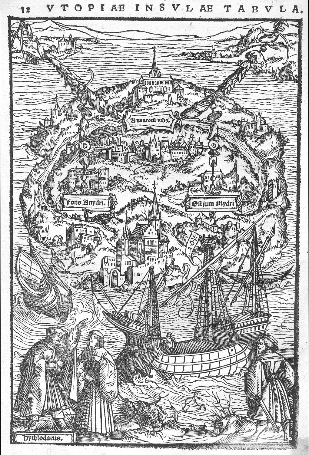
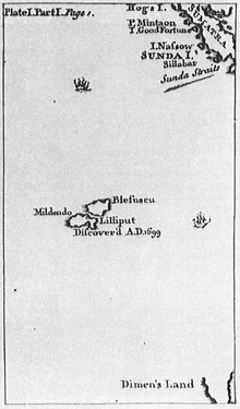
The use of maps to lend credence to propositions in the early modern world led them to embody abstractions from the map of “Utopia” Thomas More pointedly included in his dialogue of the same name, the maps of emotions Mme. de Scudery devised as Cartes de Tendre, or Jonathan Swift’s maps of Lilliput and Blefescu or Gunniland in his “proposal for correcting modern maps,” or–and here we leap centuries–modern ancestors such as Stevenson’s Treasure Island, whose fantastic claims to embodiment in maps extend all the way up to map of Middle Earth–and to those Christopher Tolkein subsequently expanded–whose publication and currency, he argued, led anyone with a computer software applications to make maps from Grand Theft Auto to map art, as map is congenial subject of exhibition.

More Utopia Map

220px-Moll_-_Map_of_Lilliput

Carte de Tendre

But are not these maps playful inversions of the operative roles of maps as tools of state–orchestrated by figures with close state roles, as More and Swift?  The role of middle-range cartographers from E.H. Shepherd to Christopher Tolkein to Jules Feiffer, to trace one genealogy, seems quite distinct.

phantom-tollbooth-map


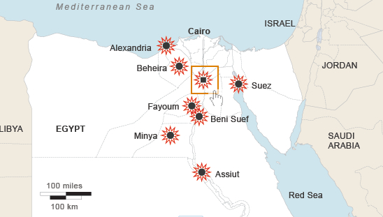
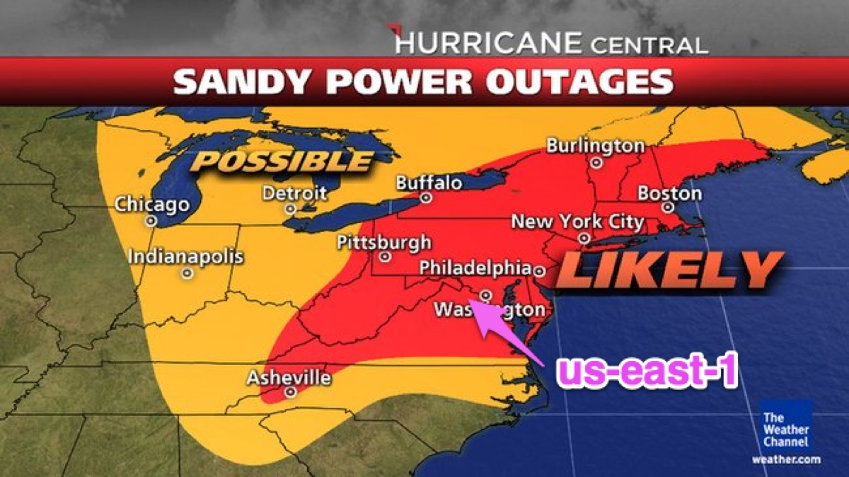
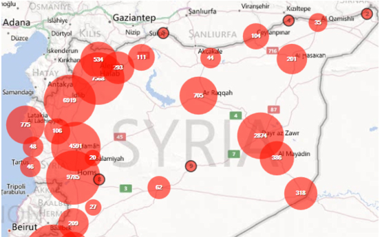
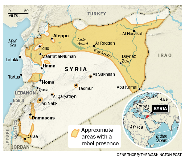
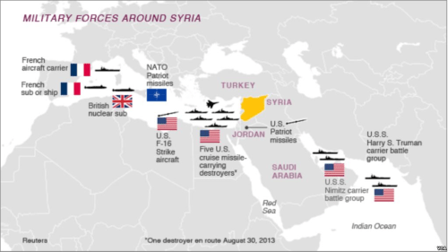
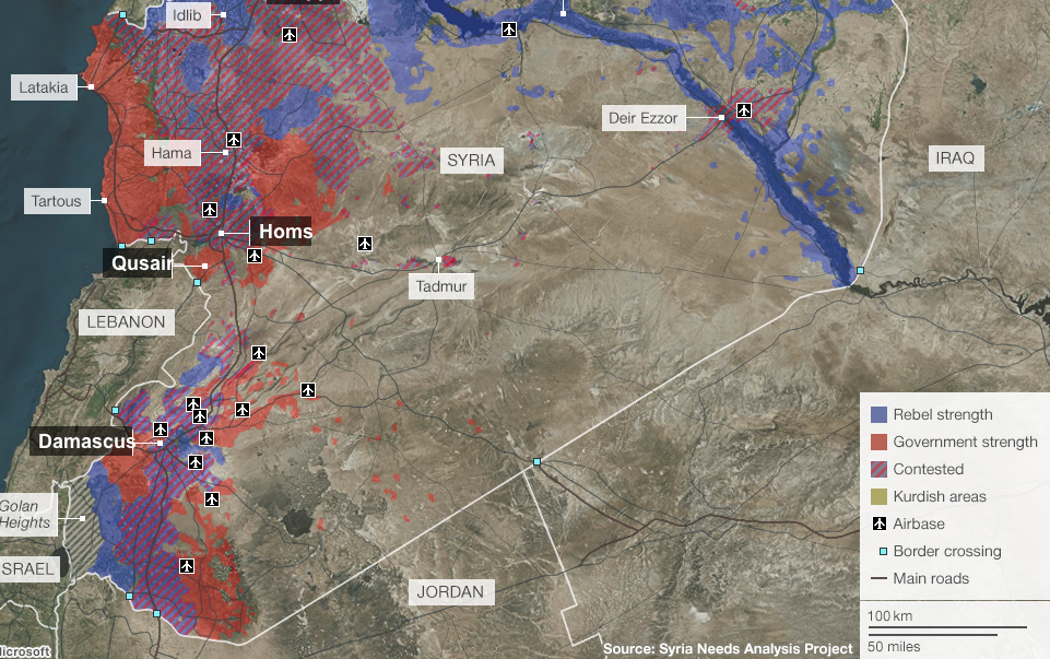
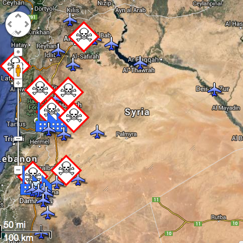
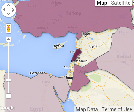
Is the state’s stranglehold on cartography at last weakening, much as Wood asserts, even with the diffusion of mapping platforms and the availability of digital mapping tools?  Wood detects a twilight of the age of the paper map as leading to an end of the dominant role that maps of states once enjoyed as vehicles to view boundaries and confines of state possession and areas of juridical control.  This does not mean that maps are less used by the state.  But that the map is less the gripping tool of engagement whose history he has traced since circa 1500, the magic date from which maps were, he argued, so instrumental in conjuring the subject of the state and so successful in naturalizing its truth claims as part of our world.  This may be curious, because of the proliferation of digitized maps that defines potentially unwieldy concepts–global warming; the ozone hole; hurricane Sandy’s path; plankton algae bloom distributions–that can be latched onto in public debate and, occasionally, grasped.  Or, on a humanitarian level, the sort of crowd-sourced map of deaths in Syria’s civil wars, legibly tracking a succinct geographic table of the distributions of killings, rapes, revenges, and poisonings or the humanitarian disasters of the Syrian refugees whose number has far surpassed two million.
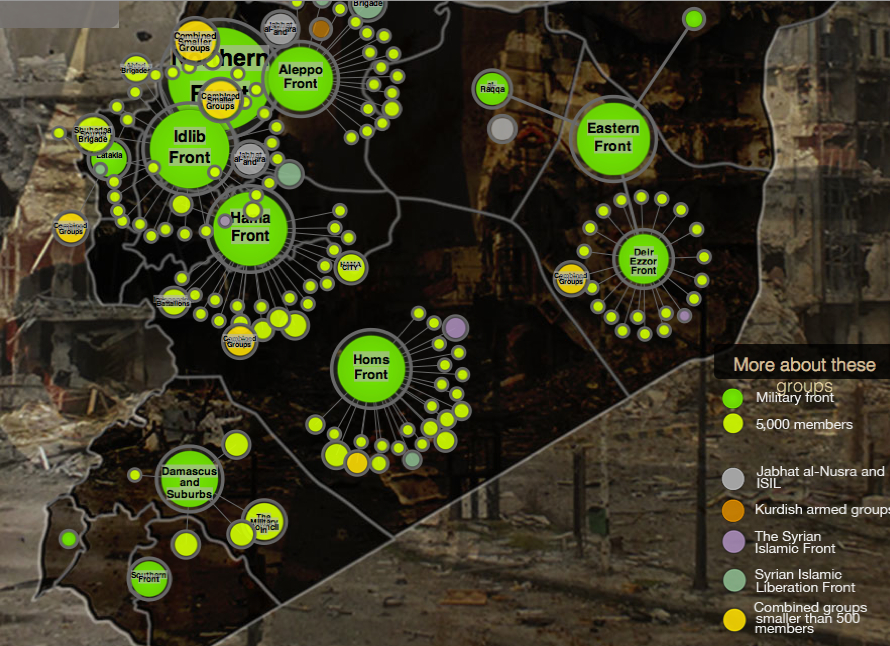
Crowd-Sourced Mapping of killings, rapes, revenges and poisoning

Syriatracker

Syrian Refugee Crisis


We can also distinguish better and worse attempts to map  tragic humanitarian disasters among these visualizations.

One may, indeed, ask what constitutes the state today–and try to map it–or try to define to the widespread distribution of mapping functions within states.  Wood presented the insanely rising prices of old maps sold at auctions today as making something of a mockery of the idea that states so monopolizes the use of maps that it cannot but illustrate state functions.  But are not these maps, now evacuated of meaning and illusions of power, disquietingly assuming a role, retrospectively, as images of a world where power worked differently, or of an age when the design of maps was performed with such due diligence and care?

But Wood is perhaps too happy to say goodbye to the map.  If this grammar is not that much less operative, is it true that the state’s stranglehold on cartography is now weakening or has weakened?  Or that cartography–and the illusion of the map–has outlived its function as a basis to visualize the nation?  Wood doesn’t find that the state can any longer repeat the trick of naturalizing its own presence through the operations of naturalizing with GIS tools, partly because of their lack of similar persuasive skills.  But if it may be argued that the state has no need for the same truth-claims any more, as they are, somehow, finding themselves to be outdated, that doesn’t mean that the collective power of mapping does not exist outside the purview of the state, and as an activity of resistance and calling into being new information, as several other papers delivered at the same conference by Annette Kim and Rebecca Solnit showed.

But although maps arose in needs of nation state to take on form, and organize its interests, rather than seeing some sort of triumphalism continuing in the use of maps to shore up the nation-state, from Raleigh, NC, Wood doesn’t see the map as doing that good a job even as a tool of surveillance.  And he sees the use of maps to call attention to historical practices, and even to restore historical landscapes, as well as address issues of social justice, as marginal to the disappearance of the map as a tool of state control.  The declining efficacy of the sort of operations that maps were able to accomplish, he notes, seem to have contributed–notwithstanding the omnipresence of maps in our lives–to its declining authority, more than a ‘democratization of mapping’ can be celebrated. But as the functions of state-power also seem to be less clearly visualized–and preserved–by means of maps in an increasingly interdependent world where the concept of the boundaries of a map have less meaning as fabricating a category or signifier out of whole cloth, perhaps the map would enjoy new versatility as a tool outside the rubric of the state that so long sponsored it.

If one can talk about a geohumanities that extends beyond those with digital expertise, who engage in studying and producing the culture, that would depend on understanding of ‘map making’ not only as a practice, but as a verb engages other contexts, and a verb that offers something like a grammar in conversation that is specific to the map as an object, distinct from other accumulations of evidence, as well as appreciating the role of mapping as an art.  If in an age of such widespread collations and ordering of evidence, the paper map–and the official map–is somehow rendered obsolete, even as multiple maps continue to wage authority in ordering our lives.  But the ubiquity of Google Maps can be resisted, if only by making its origins better known, and its the limits of its practices evident.  To be seduced by their objectivity is surely to ignore the continued power that maps still have.  If maps continue to offer such a pleasurable area of exploration in Grand Theft Auto and other media, it seems likely that personal meanings maps afford provide not just diversions in the esthetics of map making, but appropriations of an all too familiar authoritative form to define boundaries of inclusion and exclusion, trace networks of meaning, and give stability to collective entities, even in the age of the slippy maps fabricated by Google that convert declassified satellite photographs to easily downloadable tiles.

Wood’s prognostication of the death of the map seems premature.  Perhaps we, as consumers of digitized information, pay attention to its grounding in geographic reality and its operations, and are also less susceptible to the sequestered codes contained within maps, or the truth claims of a single map’s persuasive form.   Perhaps the map’s near-ubiquity cannot but decrease its authority.  But we do seem to stand at the brink of a future where mapping is ever-present as a form of surveillance; perhaps a society in which power has learned to work in new ways, unmoored from maps to define power and realize or recognize its bounds, but has adopted mapping forms as dispersive ways to organize power claims.  But in this society, maps can gain new power as media to realize networks of which too few seem aware.

Wood suggests that the map is dead, perhaps, as a useful tool of conversion in the arena of state.  If the act of mapping seems less clearly situated in the arena of the state, or less dominated by the state, this does not mean that maps are media that don’t still mystify relations of power.  And if the leaks of Edward Snowden have shown that the state is surveilling us to a far greater extent than ever imagined was the case, Wood found little evidence that that has made so much of a difference, or that that helps states do much of a better job.  The query cannot but arise in response:  did the map ever do that much of a functional job, or only a basis for imagining a state that performed its functions well?  Long live the map, perhaps as a form of counter-mapping.

Leave a comment

Filed under Google Maps, infographics, mapping state interests, maps and state formation, newsmaps

Targeting Sites of Attack in Syria


Syria, for now, remains on the map.  But in the course of over two years civil war aged across Syria, the government of Bashar al-Assad has stock-piled chemical weapons as a last line of security in multiple sites.   President Barack Obama’s administration has made use of chemical weapons against Syria’s population a justification for military attacks against or intervention in the country.  But the prominence given to drawing this “red line” on the use of such weapons neglects to assess the pragmatic results of any intervention, and the nature of what form on-the-ground intervention in the relatively shifting state would take–or what ends such military actions would be able to serve.

The direction of the situation is not good, to be sure. The number of Syrians reported killed, abducted, gassed, or poisoned during the civil war over the past two and a half years, tabulated by Syriatracker, clearly centers the focus of violence around its capital city, Damascus, and is probably vastly under-reported:


Syria Tracker- Missing, Killed, Arrested

The on-the ground situation is more complex than this map of reported violence:  especially if one looks at the disparate groups that have independently continued (or sustained) the ongoing rebellion against the Syrian government, or, even more strikingly, at the huge number of internally displaced Syrians, a number greater than anywhere else in the world; and the  number of Internally Displaced People is difficult to count; estimates are 4.25 million–almost 1 in 5 Syrians.  The consequences of this displacement are impossible to map.


The situation on the ground has provoked this displacement through the fragmenting of the Rebellion into multiple fronts.    An important and informative interactive Al Jazeera map of groups in the Syrian rebellion provides a far more complex measure of divisions among rebellious groups that have attracted different financial and military backing to overthrow Assad also challenging to map:  rebels on different fronts include the large Northern Front near Damascus to Aleppo Front, Idlib Front, and Eastern Front, some in uneasy relations to one another, and is worth examining in depth at its website, in order to understand the mosaic of divisions in a landscape whose sectors are often pointlessly divided between “rebel-held” and those where Assad is dominant:

Mapping Interactive Map of Syrian Opposition
Al Jazeera English

The above image of the fragmented nature of local control, and the independence of each group from one another, suggests the difficulty of defining a clear point of entrance and reveals the nature of ‘proxy war’ that has expanded over two years since the Arab spring, as the response to the Arab Spring of April 2011 that challenged the Assad dictatorship were almost randomly attacked by a violent militaristic security forces that echoed the violent tactics of Bashar’s father, firing live bullets into crowds of protestors and unarmed civilians, killing many innocent children, in acts of carnage and terror documented by Human Rights Watch as killing 587 civilians and over 250 children that emulated the theatrical mass-assassinations orchestrated against Syrians by his father, Haifez al-Assad.  The repressive violence of these events, before civil war, increased the range of foreign bankrolling independent factions of rebellion, which is misleadingly cast as uniform by a map of anti-government forces as the below two-color map devised for Max Fisher of the Washington Post, which borders on intentional political disinformation:

syriaForMax-2


Despite using a uniform color to denote “rebel presence” as a single, uniform beige to mask divisions within “rebel presence” and the numerous individual deals that the Assad regime might make within them–and mask the actual of what David Brooks and others correctly identify as a “proxy war” between Russian planes flying from Iran over the nation, Hezbollah present in Syria, and with multiple “combustion point for further waves of violence.”   The war is, in fact, not properly “civil” at all, so much as a broader war for the realignment of Middle East politics–and despite the attempts of previous administrations to involve rebel groups within the negotiation, the readiness with which the Trump administration seems more ready to strike–or threaten to strike?–from the eastern Mediterranean, Persian Gulf, and Red Sea–with less attention to the ethnic composition of Syria, than its own show of strength.


image.png


We have been particularly ill-served to understand the nature of this “proxy war” by the reductionist attempt to map ethnic diversities in Syria as if they revealed an internal fragmentation of a nation that is being driven apart by exterior forces.  Such a map implies that the many sectarian divisions masked by the creation of the Syria’s borders account for instabilities among rebel groups, as if they are inherent in a multi-ethnic state as an amalgam of faiths destined to implode, regardless of the brutality of the two generations of the Assad regime:

Levant_Ethnicity_lg-smaller1-zoom

Yet the divided nature of the country lies in part in the improvised nature of resistance to a totalitarian regime, and the culture of violence that has been normalized within the Assad regime and within Assad’s security forces–the notorious Air Force Intelligence (إدارة المخابرات الجوية‎), whose ties to chemical weaponry have been substantiated in the recent past.

The drawing of stark divisions between areas controlled by different fronts and subject to government control obscure the near impossibility of drawing these lines of distinction along clear territorial boundary lines–and prepare a deceptively simple image of Syria’s future.  One BBC news-map helpfully re-dimensions the local conflict, mapping government positions toward the coast and eastern cities, around holdouts and temporary redoubts of rebel resistance–although clear mapping of their division is difficult given the shifting landscape of alliances and lines of territorial defence among highly mobile guerrilla forces, who often tactically withdraw, rather than face military engagement, but can’t map the shifting lines of opposition or control–or the relations between the fronts that are themselves supported by different constituencies in a patchwork of strongholds:

Mapping Syrian Conflict BBCBBC/Syria Needs Analysis Project


The map poses deep questions of what intervention would mean without a clear map even available to be read.  They also reveal how much the debate about war is being waged not only in words, but maps.  The focus of global attention is not only on the violence that has divided the country for over two years, to be sure, or the humanitarian disasters created by the many refugee camps on Syria’s borders, but allegations of the use of chemical weapons.  Yet the mapping of Syria’s disasters and composition are central to any discussion of military intervention.

And we now have a map of where strikes might be directed against air force bases and sites of chemical production, courtesy Foreign Policy magazine, which uses a Google Maps template to mark the storehouses of potential chemical factories and air bases targeted as primary sites of missile attack:

Air Bases and Chemical Sites in Syria


What sort of a vision of Syria as a country does it describe?  The visually striking deployment of skulls-and-crossbones icons to designate locations of plants that produce chemical weapons is scary, and so much so that it almost evokes incursions by pirates along the Mediterranean coast–as much as sites of chemical weapons.  (Of course, such sites would not in themselves be targeted, but the decision to avoid them depends on the accuracy of military intelligence; the decision to target all pharmaceutical factories also poses a  future crisis for already over-crowded Syrian hospitals.)  But it suggests a rather blunt map of the notion of military intervention, and reveals the difficulty of projecting a limited surgical strike against selective sites that are removed from the Syrian population.

In the light of the relative military success of the long-distance bombing strikes into Algeria, it seems tempting and morally compelling option to end the violence and self-evident terror of gas attacks by unseating the Assad tyranny, or by providing Syria with a clear warning–although what it would warn we are not sure–against purposefully deploying chemical agents against its citizens.

The map raises many questions by marking so many facilities along Syria’s Mediterranean coast.  It makes one wonder how such a map became so easy to reconstruct–and the wisdom of allowing such a plan of attack to be rendered public on the internet.  For the map suggests that strikes can be easily launched, in a sort of war conducted from aircraft carriers at a distance against Iran’s close ally, firing Tomahawk cruise missiles at them from American warships moved to the eastern Mediterranean–although it’s relatively easy construction has led many to openly wonder why such a detailed range of options would be publicly leaked by the White House in such detail, even indicating the targets of a strike of one to two days against fifty specific sites.  (Reuters found redeployment of many key army, air force, and security headquarters buildings in central Damascus that might attract U.S. cruise missiles, and poison storehouses, if not sites of production, could be moved.)  Would it be worth the potential danger of hitting a storehouse of sarin or FX?

Targeting chemical factories, moreover, does not address the likely existence of available chemical arms–although attacks render their release more likely. Every chemical plant is not the producer of sarin and mustard gas.  In imagining the raids on the air-bases and potential sites of chemical weapons, the map takes advantage of a registry compiled by the  Nuclear Threat Initiative locating where weapons are either manufactured or stored.  Yet despite the offensiveness of chemical gasses, their repellent nature, and their close historical association with threats or attacks of terrorism, what sort of counter-attack on the Syrian population the government would unleash as a response to the attack is not clear.  The attempt to paralyze Syrian aircraft who might attempt to deliver them seems worthy, but the bombing of potential plants risky at best. Bombing sites of chemical production doesn’t sound like that great an idea after all, however, since this would most likely disperse the very gasses that they contain–with more dangerous effects than the uses of Sarin or FX against the Syrian population–if such targeting would of course not be intentional.

The incommensurable relation between an air-raid or selective missile strike with storage-sites of chemical weapons has led several to question the value of such attacks, even after knowledge that the government may have intentionally used poison gas against its own citizens.  There is a small likelihood of eradicating more than a small portion of stockpiled chemical weapons in the country, since, unlike biological weapons, most probably will only be widely dispersed by such a blast–and conceivably hurt civilians as they more widely and rapidly disperse, considerably raising the bar for “collateral damage.”

How any such sort of attack will change “action on the ground”–and the questions of what military strike can alter the humanitarian and moral disaster that Syria has already become–remind us of the pressing need to have a clearer map of the action on the ground than a Google Map can reveal, as we examine consequences of a “limited air strike” beyond the hope to cripple the Syrian airforce or discourage the terrifying possibility of further use of poisonous gas against an opposition–and ask if a “limited air strike” is possible in this complex geopolitical microclimate.

Lastly, the mapping of clear targets and divisions within Syria’s boundaries obscures a hidden–but important–map of refugees on the borders of the country.  As well as having internally displaced millions, the fragmentation of fronts in the country have created a growing humanitarian crisis in camps on Syria’s borders, and the 3.5 million refugees who are estimated to leave the country by the end of 2013 for neighboring regions, further fragmenting and dispersing the country’s population:


map refugees Syria by 2013 3.5 mill


Color-coded according to the largest number of Syrian refugees received in each country, we range from deep purple in Lebanon (more than half a million refugees dwell), and just less than half a million are in Jordan and Turkey, and smaller numbers in Iraq and Egypt  – 161,879 and 75,456.  This alternative geopolitical map serves as a negative view of the strategic relations between he nations.  It also poses a problem of how each of these countries respond to the crisis:  such a data-visualization fails to render the different immediate challenges of each refugee family, their poverty, and their amassing on the borders of each region, rather than throughout the country.  For this is a humanitarian disaster waiting to be mapped.

Given the difficulty in mapping the multiple divisions within the country into rebel and government forces, and the crises of internal and external displacement of Syria’s population, we must resist seeing mapping clear targets of attack.  The maps of clear divisions in the country as a clear opposition of forces are distorting filters that are more distracting than they are informative, with overly neat and tidy boundary lines.  The complex conflicting rebel factions supported by backers, and the sort of power vacuum that would be created by significant and serious destablization of the country or desperate responses (or the shifting of responsibility) that strikes against the country’s remaining inhabitants might trigger.

Syria’s conflict of course exists not only as a map of frontiers and inhabitants.  Worldwide, it should be remembered, there remains significant opposition to military intervention, charted by Mona Chalabi and Charlotte Henry in the The Guardian’s datablog–not only because of longstanding alliances between Iran and Syria, or Syria and Russia, but exceedingly complex questions of what ends intervention would accomplish–and what outcomes it would produce, as well as how it would be sustained.


Condemnation of Intervention


Viewing the conflict in Syria not only through the lenses of national alliances, but by what can be best mapped on the ground, must become more central to US foreign policy objectives.  We cannot “chastise” or “wound” the Assad regime without realizing that we may wound the country, or erase it from the map.

All too easily, from the point of the United States, at least, we risk viewing the conflict either too much on the micro level, or at a remove of the capacity of bomb strikes, paying far less attention to the delicate nature of the situation on the ground.  Indeed, the faux apocalyptic tenor of some maps of imminent war that is tragically advanced by right-wing bloggers, that strip the power of cruise missile strikes from their context–


image


–suggests a removed image of the ability to launch air strikes against a nation at a remove from the ground, and an ability to “target” strikes–the illusion of GPS–at a single dot, without registering the huge impact such strikes would have on a country and is inhabitants.  In an era of shooting first and asking questions later, by 2017 we use maps to fire from the hundred and five missiles on Assad’s “chemical weapons facilities” as “surgical strikes” by tools able to pinpoint chemical weapons storage and research facilities outside Syrian cities, as if they have a fixed non-human target to eliminate.


APTOPIX_Syria_US_88463-cf2b5Targeting of Syrian Capital on April 14, 2018/Hassan Ammar/API


Can the promise of mapping with such precision inflate a sense of the ability to intervene from a remove, targeting targets outside Damascus as the Barzah Research and Development Center, or the Him Shinshar complex outside Homs, without terrorizing the Presidential Palace, and without worrying that such armed interventions will not eventually escalate, as they dramatically change the experience on the ground?


image.png

8 Comments

Filed under Mapping Chemical Weapons, mapping ethnic groups, newsmaps, Syrian Civil War

The State of Emergency in Cairo’s Streets

With an overwhelming display of strength usually reserved for clearing Palestinian settlers from villages in the Sinai or Gaza, Egyptian police forces descended at 7 a.m. on the sit-in at Nasr Villages’s Raba’a al Adawiya Square, near to the Raba’a al Adawiya mosque in Nasr City; indoor viewers watched non-stop footage on their television sets.  Attempts to map the site have been oddly silent about the crackdown as an erasure of both a physical site of congregation and a symbolic site of open congregation, whose symbolism was tied not only to the mosque but to its autonomy–and less clear on how the symbolic connotations of the site mapped onto its destruction, for all the photos of both carnage and charred remains.

The demonstrations had been themselves some sort of micro-city, a testament to the organizational abilities of the Muslim Brotherhood, with entrances, checkpoints, and security committees.  Other sites to register protest emerged, but were more easily cleared because, unlike the Raba’a Square, they were far less open or established, and less clearly defensible, leaving the two largest sites of demonstration at the university in downtown Cairo and at the mosque; protesters congregated at the mosque from June 28, or before the Constitution was suspended on July 3, which became the epicenter of protest; after government demands to end sit-ins August 11, the Raba’a sit-in dramatically grew.

Clashes Mapped

The site of the “camp” itself, however, six miles in proximity to Tahrir square on an intersection of two-way streets beside a mosque, occupied a substantial chunk of civic space:

_69245059_protest_area_1_624

There was an initial attempt to map the “Morsi Sit-In” on the Al Jazeera network, as if to reaffirm its size.  But the template of Google Maps can hardly come to terms with the mini-city created by the organization of entrances and check-points around the mosque, let alone the violent nature of the eradication of protestors–steamrolling the place, dispersing protestors by fire and tear gas canisters, and violating the site of the mosque.  The occupation grew around the traffic hub of El-Nasr road, around the hub or nerve-site of the mosque itself, that convey its breadth and “infrastructure” as a movement.  The map’s red dots of settlements are densest around the mosque, and define the ring around the neighborhood that had been surrounded with entry points before the order was given for army soldiers and police to move in, firing tear gas canisters to disperse the crowd and advancing into the square, where fires burned as police reportedly arrested more Muslim Brotherhood leaders as well as protesters who occupied the square, and entered the mosque itself:  encampments burnt, the barricades surrounding the mosque destroyed, officers fired live ammunition as well as rubber bullets on retreating demonstrators, and protestors burnt tires around the last space the Islamic Brotherhood held in Cairo.

Mapping the Pro-Morsi Sit-In
satallite Nasr City

But the intersection of El Nasr Road in Rabaa al Adawiya functioned as a vital and living site in ways difficult to map without bodies.

Rabaa al-Adawiya

The entrance of armored bulldozers on August 14 seems to have intentionally obliterated any trace of the occupation of the square, where settlements had sizeably increased from August 11, killing upwards of upwards of 623 and wounding thousands.   Since vouching two months ago to protect Mohammed Morsi’s presidency “with soul and blood,” the protestors in Nasr City equated their occupation of the Cairo square with the occupation of Tahrir Square, a site earlier filled with anti-Morsi protestors, but  the initial site of and platform for anti-Mubarak protests:  Morsi supporters by the mosque promised sought to rest the voice from those in Tahrir who had called on him to leave in late June.  The protestors who have settled in the square have created a sort of miniature city, much as Tahrir Square had been, as a public space, complete with tents, lavatories, improvised kitchens, and even dormitories, giving it a clearly contestatory role in the city’s geography–now cleared of inhabitants, save improvised clinics, hospitals, and improvised morgues.  If Tahrir provided a sort of voice of the nation that call for Mubarrak’s resignation, and later for the end of the Morsi government, Raba’a seems something like a counter-voice of public debate:  the occupiers refused to leave until those at Tahrir disbanded.  While the al Adawiya mosque had been a site of site of assembly and congregation of the dissolved Shura Council–planning to convene its opening session from July 21, a site of a shadow government of Islam from July 21, in response to the disbanding of the Shura as a legal body.  (Although press coverage has focussed on the mosque, it has ignored the dual function of the mosque as an alternate site of governance.)  The mosque is now in ruins; the Al-Imam mosque also in Nasr City an impromptu morgue.

The territory around the mosque and the building was a focus of military aggression by Egyptian troops, as if the site of meeting needed to be obliterated from cultural memory. The response to the sit-in in Raba’a reveals it to be as politicized a territory defined by streets as the Parisian barricades, where every inch was contested.   The government’s prime charge was ostensibly that they had come to obstruct traffic at a busy intersection in Cairo, and obstructions had to be cleared from the site.  But the mass arrest of protestors and the violence of the response to clear the square, evident in the below photographs, suggest that a decision to obliterate any sign of their presence was the symbolic capital of Muslims in the city.  The notion of obstructions to traffic was not only a pretense, but a metaphor for how the Generals felt about the protest.

Indeed, to feign to hear to other voice within the demands than a traffic obstruction is belied by the extent of any material remains of the tents, houses, and dormitories that existed there, as if to erase them from a historical record as well as to preserve their control over a divided urban space.

egypt-tents-set-on-fire

egypt-woman-rabaa-580Mohammed Abdel Moneim/AFP/Getty

Cairo-august14-004Detention of demonstrators near Raba’a al-Adawiya mosque.  AFP/STR/Getty

6454e3a1-41d5-4d2f-be7d-0f923630c786_500AP/Ahmed Gomaa

Was the site of the mosque the target of such destruction? And after the fires at the Square, the mosque itself was burned, its sides were charred by smoke and interior demolished, as if to destroy the symbolic center of the protest itself that had provided shelter and refuge for debate from June:  after armed forces dispersed attempted to continue the sit-in in Moustafa Mahmoud Square in Giza, subsequently to the dispersal in Raba’a, protests marches have been organized in response from some thirty Giza and Cairo mosques to Ramses Square.

rtx12m95REUTERS/Mohamed Abd El Ghany

rtx12m9h

As violence spread into other neighborhoods in Cairo and to cities throughout the country, with churches and government buildings desecrated or destroyed, Egypt’s government declared a thirty-day state of emergency, and a curfew.  The next day, the deployment of armored vehicles around Tahrir Square the next day seemed designed to prevent the capture of another stage of public visibility.  Soldiers also stand guard over the ruins of the mosque where the protests began.

assess-popupBryan Denton for The New York Times

The square in Raba’a was filled with crowds from early July, according to Business Insider:

rtx11dtd

The site of the mosque and the center of the protest is now being swept clean, the crowds long scattered and dispersed.  The violence has spread to other neighborhoods and cities that might not be able to be clearly mapped, after troops violated the significance and integrity of the square.

Supporter-MOrsi Clashes

One might remember that a very different, if antiquated, image of the integration of mosques within the skyline of Nasr City, Heliopolis, and the surrounding neighborhood:

Nasr City Map

1 Comment

Filed under al Adawiya Mosque, al-Adawiya Square, Cairo, Google Maps, Mapping Cairo, Mapping Morsi, Mapping Protests, Muslim Brotherhood, News Maps, newsmaps, Tahrir Square