
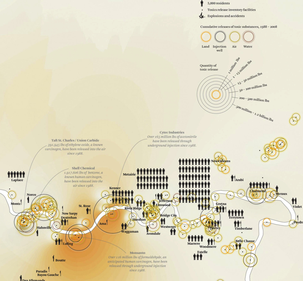
“Cancer Alley” does not itself appear on maps. But this eighty-five mile stretch of the Mississippi River between Baton Rouge and New Orleans, into which are packed some one hundred and fifty factories of petroleum refining or chemical production, merits the name since its notorious wastes have grown so large to define the local landscape to merit the name–the amount of toxic and hazardous wastes that they regularly release has overwhelmed the landscape, all but crowding out all local place-names.
The simple austere presence of names of chemical compounds, no doubt sized in an elegant Times New Roman in a font-size that corresponds to their relative production, suggests an imposition of meaning inscribed on the map, stripped of any actual toponymy, save the ghostly half-tones naming the corporations who have remade the landscape as a site of corporate refineries and chemical production, where the refinement of carcinogenic materials extracted from underground threatens to overwhelm the landscape: a black thread of a river may be traced where the Mississippi meets the Gulf of Mexico, whose serpentine course of solid black carries broad public health implications for the nation we endanger ourselves to neglect.

Kate Orff, “Ecological Atlas to ‘Petrochemical America'”
The banks of this Louisiana Bayou landscape on which so many sites of the manufacture of petrochemical products are nested, transformed a former a site of sugar and cotton plantations into one of the most polluted areas in the United States of America. The petroleum refineries, chemical industries, and hazardous waste containment sites along the winding river are a stark contrast to the sinuous bends of the lower Mississippi, but suggest the deep transfiguration of place that has occurred, complicit with the erosion of so much of the wetlands region near the Louisiana coast into the open waters further downstream. The smokestacks of factories of chemical synthesis produce clouds of emissions that have led it to be named “cancer alley” to reflect the high rates at which residents of the area. Most of its current residents–largely poor, poorly represented, and largely African-American and with strikingly low levels of educational attainment–have been victimized by the discrepancies of environmental protection in the nation’s geography as a whole.
The question of mapping pollutants in the region is truly not only a map limited to one area, but suggests an atlas–a term Kate Orff adopts in her map–of the underside of the national consumption of petroleum products and their synthesis for American markets, compressed to one small region of the lower Mississippi. Even as American Presidents have taken it upon themselves to declare for over fifty years–we can date the metaphorical call for the moonshot that Joe Biden oversaw as Vice President to cure cancer all the way back in 1971, when Richard M. Nixon called for a national effort to conquer “this dread disease” from which Americans suffered through “the same kind of concentrated effort … that took man to the moon,” as if an anticancer blastoff was waiting in the wings, the “war on cancer” that Nixon sought to begin as the Vietnam War was winding, there was a sense that the “war” didn’t pay much attention to the grim landscape of postindustrial waste and pollutants and hazardous waste that refineries were emitting into the beautiful bayous where the Mississippi opens into the Gulf of Mexico whose dangers were claimed to be avoided and superseded by “research and therapies [that] are on the cusp of significant breakthroughs,”as Joe Biden Biden put it as he corralled the nation to join him in a national mission to develop both therapeutic treatments for cancer and liberate “science, data, and research results [that is currently] trapped in silos, preventing faster progress and greater reach to patients. It’s not just about developing game-changing treatments” promised to be on the horizon of being delivered. While privileging immunotherapy, genomics, stem-cell research and combination therapies, the expansion of petrochemical industries between New Orleans and Baton Rouge grew, creating carcinogenic landscape along the banks of the Mississippi continued, its landscape covered by a smokescreen despite the promise of increased access to information for the community of oncologists who treat cancer patients.
If much fanfare accompanied a “new national effort” designed to “cure cancer” by the federal government in 2016, federal oversight over petroleum pollution has seemed to retreat. Despite the “inspirational” nature of such calls for cures, backed by a billion dollars of investment in cancer immunotherapies, vaccine development, genomic analysis and data sharing, the lack of attention the increasingly global context of increasing cancers in “developing” countries where most extractive industries are based–currently projected to grow from 55% to over 70% of global cases of cancer, where Paul Farmer found an overwhelming 80% of disability-adjusted life-years already lost to cancer globally: the lack of attention to unequal translation of such compelling calls for a “cure for cancer in American research universities conceals a global “disequilibrium” mirrored in the lack of access to costly coronavirus vaccines. Is the lack of attention to therapeutic best practices for mitigating cancer’s spread, mirrored in the absence of attention or objection to the expansion of industry on the largely abandoned riverbanks? Or is it that the land long habituated to extraction has provided a new industrial landscape for the benefit of petroleum refining, with limited federal oversight?
The absence of expanding cancer prevention programs in America that might translate globally is mirrored in the lack of attention to petrochemical pollutants along the rivers course, that have transformed the region into an unmapped or identified Superfund site–beside urban populations and endangered wildlife. The over 26,000 pounds of vaporized ethyl acrylate that have leaked from the stacks of the Dow Chemical plant–without a fine–or the forty-six thousand tones of toxic water in unlined containment sites of hazardous waste emitted daily. If the concentration of creaky and leaky factories on the winding end of the Mississippi is peculiar in its proximity both to urban populations and stupendous bayous inhabited by endangered species, the map reveals a sort of legibility in the landscape that at times seems threatened to be lost. Indeed, the map can only hope to capture the injustices created by the dense proliferation of industrial petrochemical refineries along the river, site of plantations in years past, settled with poorer populations living between New Orleans and Baton Rouge: the industries have not gone under the radar of government environmental agencies, but the industries are itself part of the region’s landscape, not removed from its surrounding dense cypress groves and former mangroves in what was once dense with plantations and wildlife.
Viewers of Kate Orff’s map are forced to confront the density of sites of chemical production and register how the collective industries that crowd the end of the Mississippi have created a post-industrial landscape of toxic waste that both permeates and engulfs the region as a whole. The historical expansion of chemical industries along the winding river has grown with their increasing use of petroleum or conversion of chemical products that are derived from oil, coal, and natural gas. Orff’s mapping of the spectacular concentration of industries that synthesize propylenes for acetone or plexiglass or antifreeze or polyethylenes used to make plastic bags into one poor residential region serve not only as a map of part of the bayous, but a map the petrochemical dependence of the nation, to allow us to see for ourselves the new landscape we have made. In this sense, while focussed on one riverine landscape, Orff’s “ecological atlas” charts a devastating indictment of the transformation of our habits of land use, revealing and unpacking the depth of an industrial settlements along the shores of the slow-moving river.
For the eighty-five mile of bayous, no longer populated by alligator, herons, raccoons, or ibis, are the site of the massive release of pollutants whose density of waste-products to an extent almost unfathomable in their density or extent. Orff’s remapping of one area of delta estuary on the Louisiana Gulf reveals the industrialization of a region which has also been a seat of National Wildlife Refuges–parts of the sleepy bayous highlighted in light tan–against, almost perversely, a light green map of the Louisiana landscape that remains that takes our eyes off of its pollutants, and by which one is tempted to note multiple protected areas in a region that once fell under environmental oversight.

Orff’s atlas was designed to complement the stunning photographs of the devestation of local bayous’ landscape between the two cities by Richard Misrach, one of which is reproduced below. But Orff’s river map opens the area as an area of industrial settlement, as much as population, also reveals the national landscape with which we may be left. The atlas marks the potential release of carcinogens in an area whose ecosystem of the Southeast Louisiana National Wildlife Refuge is designated as an endangered ecosystem and seat of endangered species–although many of the local species, including the American alligator and bald eagle, were “delisted” as endangered during the 1980s or 2000s. Yet rather than map the selective refuges of the Bayous, seats of hunting and wildlife fishing, Orff offers a chart the consequences of the region’s historical transformation from an agrarian to petrochemical industry that provides something of a narrative of the region’s transformation to a site of chemical synthesis. This provides something of a counter-story–and counter-map–to the Delta National Wildlife Refuge, including the largest urban national wildlife refuge, the Bayou Sauvage Refuge, of 24,000 acres of freshwater lagoons and brackish habitats, including herons, pelicans, and cormorants–an area of restricted waterfowl hunting and fishing.
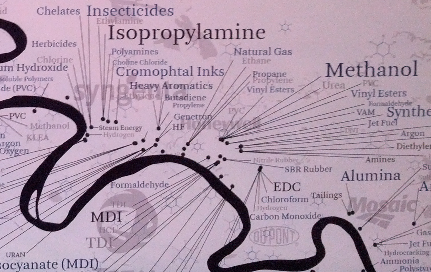
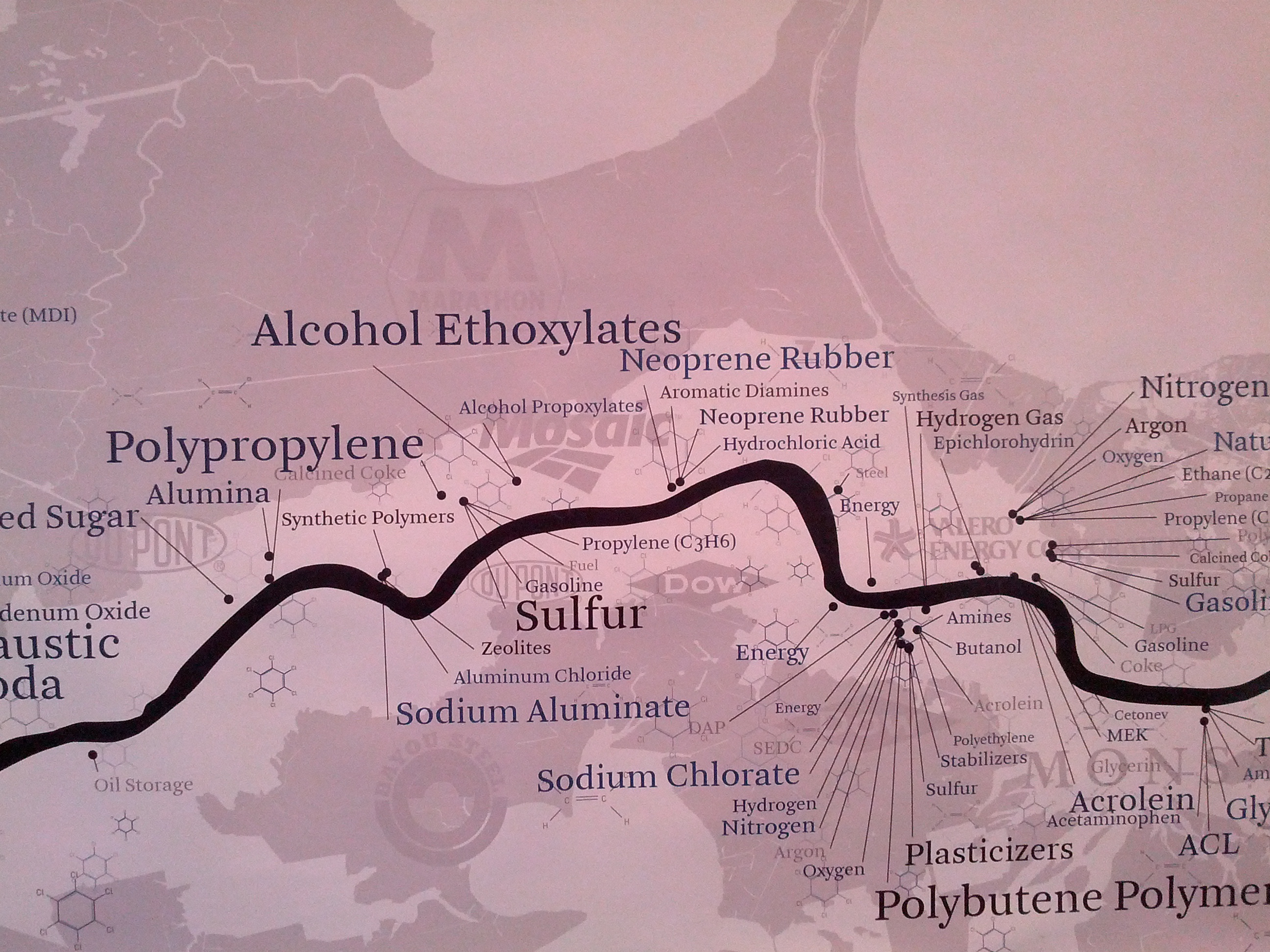
In the waters Orff maps a region just upstream of the Refuge, many products with which we have daily familiarity appear in different guises, and in a concentration that reflects the huge forces of demand for petroleum products–for inks, insecticides, plastics–in a cocktail of methanol, synthetic nitrogen, hydrochloric acid, styrenes, ethyl acetates, chloroform, kerosene or formaldehyde–a veritable catalogue of toxicity crowded into one place. The map offers a veritable chart of our addiction to petrochemical products, by forcing readers to map and recognize the continued long-term presence of these industries of extraction onto a landscape in ways we rarely see, and indeed places them into a landscape that was the site of slave plantations and of longstanding economic exploitation.
What are, we have to ask, its costs? Can they even be calculated or tallied? For the environmental damages wreaked on the wetlands go beyond (if they are based upon) social justice: even though we use maps of diseases to bring into being communication of infection or incidences of illness tied to the environment, as Tom Koch has shown, it is notoriously difficult to link cancer clusters to any particular or specific exposures to warrant liabilities, and the density of chemical products in the area–which almost appears zoned for the synthesis of petroleum products–dilutes any question of individual liability for the production of toxic wastes. Cancer was, indeed, tried to be tied to environmental causes soon after it became an identifiable demographic reality in industrializing England by Dr. Alfred Haviland, based on the apparent concentrations of cancer mortality rates, in an attempt to map incidence in correlation to altitude, or, by analogy to infectious disease, either bodies of water or other biological models or determinants like parasites: but no clear geographic distribution emerged, despite the attempted identification of “cancer houses” or “cancer streets” that might allow its occurrence to be understood, as John Snow’s famous 1854 map of the outbreak and spread of cholera in London.
Although the causal connection to environment was pursued, despite apparently clear clustering the difficulty of individuating cancer-causing influences remains, despite the continued attempt to map cancer–both on different types of cancer and distinct from other potential causes–for the vectors of cancer’s causation are poorly understood. This diminishes the ability to map clear ties or relations: no clear causational relation can be drawn between illness and environment, although environmental influences are evident. The difficulty of mapping a clear and direct relation makes any cancer map impossible to draw, despite a preponderance of evidence, notwithstanding Orff’s map of the concentration of carcinogenic compounds, some of which are dispersed into the environment by the regular release of plumes of carcinogenic compounds from benzene to hydrogen cyanide and ethyl acetate.
On the heels of intense attention to the recent 2010 Deepwater Horizon oil well blowout–a toxic release that occurred not far offshore the already devastated landscape whose intense settlement by industries of petroleum-extraction and synthesis she maps–but only distinguished by the scale at which it released oil into the aquatic environment. If the site of that massive and ongoing leakage was a source of ongoing petroleum pollution even after being plugged, the map reveals the intensely embedded nature of the petroleum industry in the land that rivals the Horizon blowout in its continued release of toxins to the waters and air of the region, as an ongoing threat even in an age of multiplying projects of coastal restoration. Yet if these projects are conspicuously absent from the area covered in Orff’s atlas, the hidden nature of potentially toxic bayous of petrochemical dependence that have, with saltwater, devastated cypress swamps and mangrove orients readers a new topography of the poisoning of the wetlands.
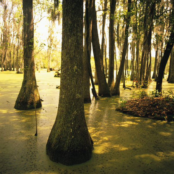
 Misrach, “Cypress Swamp, Alligator Bayou, Prairieville, Louisiana” (High Museum of Art)
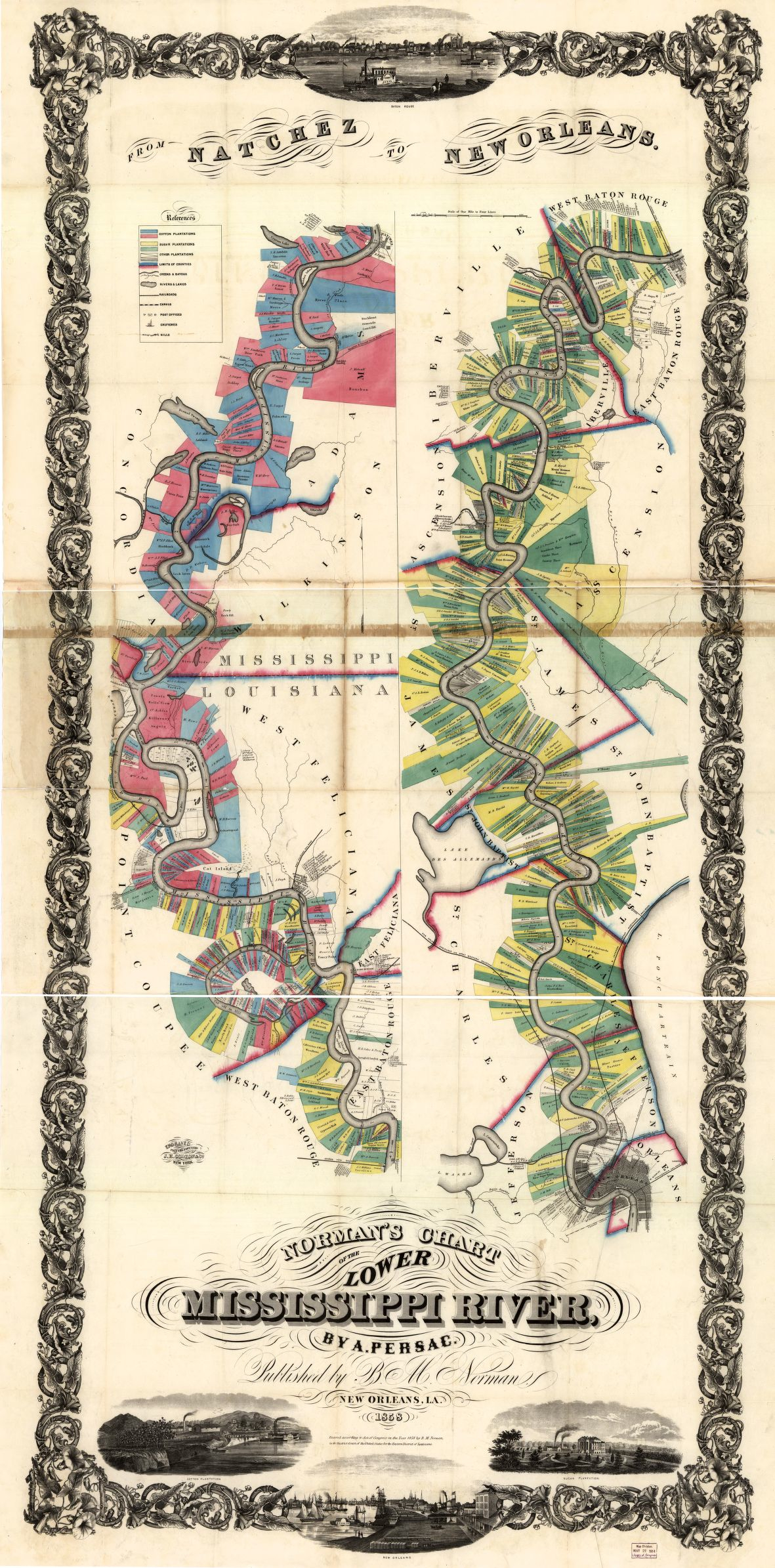
The formerly agrarian landscape of the Louisiana Gulf now industrially harvests wide array of products we consider part of our household. Its industrial production includes the synthesis of many of the food additives that enter our refrigerators or arrive on our dinner tables, the synthetic nitrogens used to make fertilizers, pesticides and herbicides that often enter, through the back door, as it were, into the food we consume. It is a source of much food consumed, with just under 20% of the sugar consumed in our country being refined just outside of New Orleans, some of the least expensive that is most likely to be added to manufactured foods. This has long been the landscape where the brutality of extraction was staged, both from plantation-based sugarcane harvesting–whose traces are still present–and cotton plantations, whose practices once crowded the very same river banks. This habitat of dense planting and day-laboring, so nourished by the bends of a winding river that it was complexly divided by plantations in a patchwork which charted land-ownership on the Lower Mississippi and now abandoned river banks with cadastral precision by Benjamin Moore Norman in 1858.
 Library of Congress
The landscape of the winding river has been replaced by a register of petrochemical products, as if they have erased and replaced the image and notion of the landscape once so valued on the river’s rich banks. Reading the names of petrochemical products in this new landscape one is struck by compounds more familiar from the aisles of a supermarket or hardware store, but now, in place of the tracts of land that so densely divided these fields, are transposed to the landscape of the Mississippi. Orff reveals a dense concentration of such industries whose products are not only made for a growing market, but whose synthesis and storage significant risks to the population and well as its other inhabitants. Crowded in the liminal landscape of coastal wetlands composed of former marshlands and pastures, many of them formerly rich ecologies filled with dense trees from bald cypress, black cypress, and mangrove trees–all marred by earlier deforestation and cross-clearing, we can imagine them crippled and palsied not only by the entry of saltwater but by industrial pollutants to the extent that may never be restored.

An earlier map of the bucolic landscape of low-lying lands on the Mississippi-Louisiana border haunts Orff’s petrochemical atlas, one crowded with plantation works whose coloring in vibrant yellows and greens indicate the regional density of sugar and cotton plantations in this region to which rich mineral sediment was carried by the Mississippi, in Norman’s historic map made when that land was scarce and extraction in high demand. At the same time as almost two thousand square miles of marshlands have disintegrated into open, salty waters, and channels and canals made to stave off the loss of wetlands allowed the entrance of salty waters that kill off freshwater plants, the interstate river corridor has been settled by industrial factories based on oil extraction in ways that render the earlier plantation system almost entirely unrecognizable.

Orff’s “atlas” unpacks if also conceals a dense and tangled narrative of historical environmental exploitation and change, and more than several decades of poor stewardship. For those with time to read its detail with sufficient care, it describes the conversion of the formerly agrarian area to a site of industrial production, and the rewriting of its landscape as a site for the refinement of petroleum products that feed an ever-growing American market. To the extent that the original landscape that was there–or the ecosystems that existed beside its sugarcane fields–these were effaced by the network of commercial industries from which the landscape appears impossible to disentangle, and which have mushroomed along its cheap land as the sugar industries have moved out. The network of this one corridor suggests a compression of layers of contamination and chemical production into something like a forgotten land, or a liminal riverine space where the destruction is wrought that we don’t see as part of our urban life, and lies at a convenient remove a known landscape. The factories regularly burn off excess gasses daily in production, or contaminants leech into the environment, giving the zone the name of Cancer Alley, as Orff has described in an interview on the project of environmental mapping.
The mapping of manmade carcinogens introduced into the landscape formerly inhabited by a rich ecosystem of flourishing alligators, herons and mangroves is haunted by the corporate landscape of America, revealed in the industries that now inhabit the lower Mississippi’s relatively inexpensive former farmlands, whose names appear in half-tones legible for the observer who approaches at closer detail to track the sources of these contaminants from copolymers to kerosene to insecticides and other chelates: who knew that all these elegant compounds and liquids were spawned from the same region of industrial production? The extent of environmental damages wreaked on the larger environment are based on but range far beyond the specific questions of environmental justice that they should force us to confront.

This might well be a map of the poisons that have been released into this watershed, mapping as they do a scene of a terrible crime. Although they own the land in which they work, from Exxon Mobil to Dow Chemical, Union Carbide, Shell, Honeywell, Syngenta, Dupont and TDI–present a veritable register of corporate irresponsibility. The availability of oil from regional pipelines has created an economy of convenience that pollutes one of the richest watersheds in the land, and has lastingly polluted it by the leaching of underground storage sites of hydrocarbon wastes, themselves physically present and legible in the land, as well as released into the water and air of the ecosystem itself–and whose presence can at times be detected in traces downstream in the running tap water of New Orleans.
The abstract map conceals some devastating effects of this leakage, yet also provides a window on the transformation of a land once worked by slave labor for sugar-harvesting: still filled with sugar cane, the new geography of extraction and refinement reflect and refract the degradation of the agrarian landscape. The immensity of the transformation of the landscape is difficult to comprehend in words, and words are even challenged to describe the historical layering of devastation of a formerly flourishing ecosystem: it provides the footnotes for a story of the threats posed to the watershed by ongoing entrance of toxic chemicals into the region that demands to be explored, as do the toxic waste of Superfund sites already threatened with flooding in Hurricane Katrina–sites that threatened to release carcinogenic contaminants from heavy metals to polycyclic aromatic hydrocarbon. The clustering of Toxic Release Inventories and Superfund sites in the same stretch of river from Baton Rouge, according to the National Institute of Health’s “TOXMAP”–which marks Superfund sites by brown rectangles in the map below–suggests a tragic landscape of hazardous wastes.
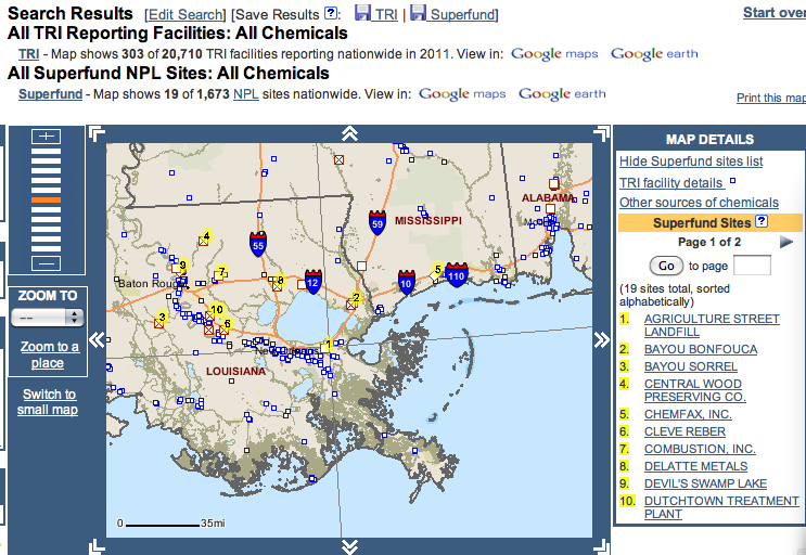

The landscape of petrochemical America compromises its inhabitants most unfairly, daily exposing large numbers of local residents to reported amounts of toxic releases between the single decade from 1998 to 2008, according to the EPA’s Toxic Release Inventory.
The Louisiana Gulf is by no means the only privileged site of such industrial pollutants–given the proliferating cycles of petrochemical contamination in an age of globalism, all bringing heightened risks of cancer and the large number of cancer alleys worldwide that now exist from the Nigerian delta, site of some of the most continuous oil flares to the rice fields and fishing grounds at Myanmar, not to mention the Persian Gulf (the global dataset on petroleum contamination here employed was originally provided by the Blacksmith Institute). And in each area, as Orff maps below, the “cancer alleys” are underwritten by corporate interests, even if they remain in the shadows of the landscape. But the gulf of the Mississippi is a veritable self-made Superfund site–notable even in a global context, and by far the densest concentration, due to the perfect storm of cheap land, nearby oil, and old factories in the Delta–not to mention limited federal oversight.

It is in many ways a return of the repressed, and the wound inflicted by the patterns of consumption to which we are so habituated. But it is perhaps also, importantly, one of the most unjustly afflicting its residents, in ways that have only begun to be assessed, and whose complicated narrative of intertwined interests and toxic production remains untold. Only by the detailed local mapping these landscapes that Orff has so magnificently achieved, and speaking out against their silences, can we reclaim knowledge of the land, as it were, and a topography where ethyl oxylates, glycols, esters or methanol displace and become more prominent features of the landscape than its inhabitants–for now, the molecular structures of petroleum derivatives haunt the land as much as the multinationals whose industries produce the “cancer corridor” that we can thank Orff for having begun to map, and whose collective responsibility for making we can perhaps all work to alter.
The photographs of Richard Misrach have been exhibited together with Orff’s maps at the Fraenkel Gallery at the David Brower Center in Berkeley, CA. The traveling exhibit will continue be on view at Pomona and Carleton Colleges until December, 2014. It is also available as a book.

