Tag Archives: occupied territories

The Office of the Geographer and Art of the Deal

Plenty of blame has been going round this election cycle on the Democratic Party for having given material assistance–if not tacitly supported–in the bombing of Palestinian settlements in Gaza by Israeli Defense Forces. The drumbeat of disquiet about the Democratic President for lending apparently unfettered support to Israeli bombs and air force in destroying the Gaza Strip is not only a cause for pronounced disquiet. The destruction may be a determinant factor in an election cycle that could open floodgates to untold ramifications of both foreign policy and domestic inequality. But as the world focussed its eyes on Gaza, we have taken our eyes off Trump’s promotion of a deeply symbolic if imaginary tie to Israel, and Israeli claims over Palestinian lands.

This tie is not only tied to imperial legacies or geopolitics, but stands to gain a new zeal, melding the early Zionist idea of a “greater Israel” with American expansionism and a Christian Zionism of peculiarly Trumpian stamp. Many believed that Netanyahu, confident in the hopes of Trump’s future victory offering a basis to enter the once and future President’s good graces, and led Thomas Friedman to argue that Netanyahu only suggested to be interested in a ceasefire in Gaza in order to achieve “total victory” of hoping to occupy both the West Bank and Gaza in the near future by escalating the war in Gaza before Election Day, in order to proclaim his ability to work toward “peace” after a Trump victory, having established the transactional value of reoccupying Gaza, while helping to return Trump to the White House again.

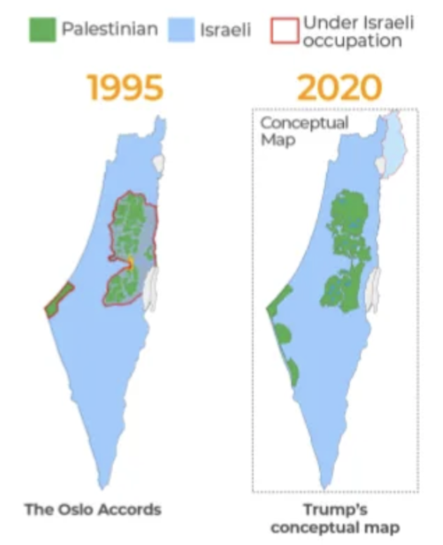
Despite the global revulsion at the killing of civilians, forced migrations, and violent atrocities, it is so difficult to process for the violence of suffering we may forget the tactical role maps of supposed peace “solutions” played preceding these struggles–and indeed how “remapping” the Middle East to defuse its conflict only served to sanction or endorse an unprecedented explosion of violence. Did the maps that the Trump White House created, assisted by the Office of the Geographer in the U.S. State Department, help to sanction a ground plan to drivePalestinians from Israel’s borders?The cartographic framework that President Trump deceptively promoted in his first Presidential term as a “Deal of the Century” was boasted to be a gift to the Middle East remade the borders and normalized the rebordering of Israel in quite violent ways. The consolidation of expansive borders was done quite aggressively-by invoking far-right Israeli ideas of territoriality of scriptural precedent removed from the ground, rooted in myth more than precedent. Trump bombastically magnified a “deal” that was of course both one-sided and deceptive, not a treaty or process of negotiation, and perhaps never really or truly on the table; it demanded few sacrifices if any from Israel even as it promised it was an end of sectarian violence.

The rather crude maps not based on GPS and drawn on paper napkins that came out of the Trump White House however became a basis for a “deal” in the Middle East gained a tactical role as Trump positioned himself as master of the “art of the deal” able to bring peace to the Middle East, born of a transactional logic of personal negotiations. The improbable prominence of Jared Kushner as alleged architect of a new “peace plan” long elusive to previous American administrations balanced a promised port, access to the River Jordan, and a cut-out boundaries as a viable future for the State of Israel, constraining Palestinians to islands of green. The “Plan,” as it was known, was never taken that seriously, if promoted as a once-in-a-lifetime “Deal of the Century, was drafted with no input from Palestinians, and ignoring all stated desires, but offering several carrots in mistaken hopes to end diplomatic stalemate to restrict Palestinians to a reduced presence in the new State of Israel. If President Trump is best known perhaps for his dictum that a state without clear boundaries is not a state, the Palestinian population would not be in defensible boundaries, or any boundaries, but linked by a set of bridges, tunnels, roads, and islands, without coherence in this “visionary” plan.


President Trump remained oblivious he hadn’t addressed the situation in a meaningful way: “All prior [American] administrations have failed from President Lyndon Johnson,” he said beside Netanyahu in 2020, “but I was not elected to do small things or shy away from big problems.” Netanyahu was overjoyed at a man he praised as “the first world leader to recognize Israel’s sovereignty over areas that are vital to our security and central to our heritage”–obfuscating words about the protection of a barrier of security in Israel’s bordering with Palestinian populations, and offering no “right of return” for Palestinians expelled from ancestral homes in Israeli territory, and offering Israel “access roads” across and between Palestinian enclaves.

The hope that if extending Israeli sovereignty “to Judea and Samaria” would anger the Palestinians, all bets were that the Palestinian Authority would in the end “maintain a certain level of security cooperation with Israel to prevent the strengthening of Hamas–as if the calculation of according Israeli sovereignty would be a step toward “peace” ensuring “dignity, self-security, and national pride,” offering a prosperity that could be fashioned out of whole cloth and promises of independent economic wealth.
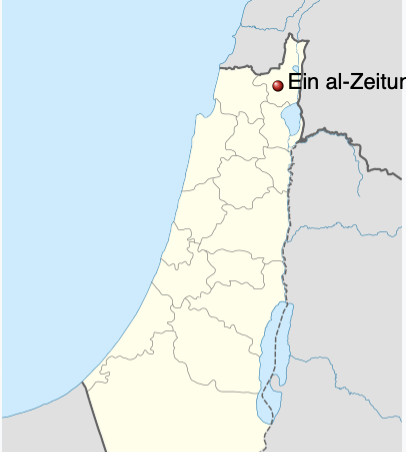
Trump” Peace Plan for Middle East, 2020

Since then, despite–or perhaps because of–the incomprehensible scale of tragedy and violence in Gaza and much of the Middle East, we have continued to consume our information by infographics and maps by territorial maps that foreground borders, as if this was a geopolitical dispute about territory, in ways that ignore how these are a new war of bordering–and often mythic borders, as much borders that can be mapped or reflect the situation on the ground, as if legal precedents–and how far we have come from a war that new borders might resolve. The very maps we use to help process attacks that are cut as border-fighting often destabilize the viewer’s perspective on the Middle East, distrusting Israeli politics, and the tactical goals of the Israeli army–and rightly so.

And although Kamala Harris has refused to distance herself from the War in Gaza, and affirmed the policy of providing support for Israel, even as the United States has little apparent leverage to shape Israeli aggression, despite her empathy for Palestinians, the endorsement of robust military action of Israel to defend its borders, and to attack trans-border threats, not only to vilify and condemn all anti-war protest with antisemitism, as part of a transnational “Hamas Support Network,” by the President who authorized annexation of the West Bank, endorse the annexation of the Golan Heights, and relocate the United States embassy to Jerusalem–the strident pro-Israel branch of the Republicans Overseas promise to secure a remade the map of the Middle East with the active contribution of a new Republican President who proclaims himself “Israel’s Best Friend” will be far more ready to supply Netanyahu with arms to defend borders and offensive weapons rather than stop their flow. If globalization ensures every point in the world can be more immediately connected to any other than ever before, a President promising to encourage Israel defend its borders and “finish the job” of extermination in Gaza blurs America’s borders with the defense of Israel’s borders and a license for far more escalated violence. The readiness with which Netanyahu has praised Trump as a “savior” for Israel, amidst the increased violence on three fronts of war.

A large billboard posted by the Ayalon highway in Tel Aviv, in support of Republican presidential nominee and former US president Donald Trump, October 30, 2024. (Avshalom Sassoni/Flash90)

Tel Aviv, October 30, 2024/Avshalom Sassoni

Donald Trump’s vaunted promise to “make America great” was more closely tied to the role of the United States in Middle Eastern politics than has been acknowledged. Trump’s “Deal” replaced true negotiation with a set of illusory promises of economic benefits, investments, and technical know how. The offering of this “deal” was presented in patronizing terms, economic advantages and promises was all Trump offered to the Palestinians, a carrot of future investments. Could it be that the death of any two-state solution lay in the ultranationalist ideologies of Trump and Netanyahu, whose respective ultranationalist ideologies, for all their differences, invoked state boundaries with massive blind spots to the situation on the ground?

The promotion of the rights of an army of settles to expand a protective buffer or envelope for Israel, the hundred mile envelope Customs and Border Protection and the Border Patrol conducted warrantless searches from any “external boundary” of the United States strips innocent people of constitutional rights–limiting constitutional rights along the entire coastlines as well as southern border, allow new technologies of surveillance in a range of technologies as a militarization of the border. If the battery of surveillance technology lack geographical limits, the border zone expanded by settlers long militarized an expansive boundary of the Israeli state, in powerful cartographic genealogy of the demands for a “Greater Israel”–a concept that found surprising acceptance and endorsement from the very individuals Donald Trump would come to nominate for key roles in his cabinet upon winning the 2024 Presidential election, Pete Hegseth for the Department of Defense, who was proposed as a key negotiator in any future military deals with Israel, and Mike Huckabee, the former Arkansas Governor and Baptist minister reborn as political commentator as the next U.S. Ambassador to Israel, who has been long committed to establish Israeli sovereignty over Gaza, impressed by the “overwhelming spiritual reality of understanding that this is the land that God as given to the Jews” while hosting tours of srael hundreds of times since the 1980s–and arguing that the very concept of Palestinian Identity is not a valid concept of governance, but invoked only as “a political tool to try and force land away from Israel.” All this is well-known. But the circulation of this sentiment among American Baptists and evangelicals across the Atlantic to reinforce or grant currency to resurrect a zombie idea of Greater Israel in the current Middle East is beyond imperial, but is a symptom of globalization, if not a symptom of the “shallow state” enabled by drafting lines of polygons in crude overlays, as if toponymic tropes of biblical tropes respond to current crises.

The conceit of a Greater Israel, at the start of the twenty-first century, is a symptom of the confused legacies that were promoted by Donald Trump and Co. to give license to the expansion of military might over Gaza, as much as the alleged failure of the United States to intervene. Would the idea of intervention even seem possible, once the entertainment of the permission to expand Israel to the West Bank and the Mediterranean was floated in the first Trump Presidency in the maps that the Office of the Geographer at the U.S. Dept of State had given their imprimatur? The maps that were made by the United States, as much as displayed by Benjamin Netanyahu to the U.N. General Assembly, suggest the deep origins of the expansion of Israeli territory in perhaps the shallowest corner of the first Trump era, where the boundaries of Israel were tacitly expanded and the two-state solution taken off the table as a desideratum. The pro-settlement ideology Huckabee has openly espoused and literally preached rests on the belief that expulsion of all self-identified Palestinians from the biblical bounds of Israel is part of a preordained divine plan for Christ’s return, opposing any two-state solution–at least, “not on the same piece of real estate.” The old conceit of “sovereignty over Judea and Samaria,” regions that did not exist on earlier maps of the Middle East, is presented as a decision “for Israel to make,” even if they were not named in any recent maps of the region, as the future Ambassador described himself as “very pleased that [Donald Trump’s] policies have been the most pro-Israel policies of any President in my lifetime.”

Applying Israeli Sovereignty to Parts of Judea and Samaria according to the U.S. Peace Plan – Implications

President Trump Announcing Comprehensive Settlement Between Israel and the Palestinian People, January 29, 2020

The genealogy of these “pro-Israel” ideas rests on a reconstruction of a longtime US-Israel alliance in the optics of the rise of apocalyptic rhetoric far different from the afterlife that the Cold War granted Imperialist ideas. (The central crux of an oxymoronic credo of “Christian Zionism” denies blame or agency for the killing of Palestinians in the Gaza War, and whitewashing of Likud regime policy with Christian millennialism.). It is also less of a “vision forward” than resting on the recycling of some of the most toxic concepts of nationhood that demand to be fully examined to be understood. Although Huckabee has claimed that Trump will assemble a “pro-Israel dream team” to ensure that nothing like the bloody massacres of civilians in the invasion of Israel on October 7, 2023 will ever occur, the notion of turning the page on October 7 seems designed to demonize the Palestinian slogan, “From the River to the Sea” to an excuse to obliterator the legacy of Palestinian presence from the map–and to assert, as Huckabee claims, that the legitimacy of biblical terms “like ‘Promised Land,’ and ‘Judea and Samaria'” hold the significance “that live from time immemorial,” a nomenclature that the United States has had no small part in perpetuating.

The castrophic events foretold in the Book of Revelations were not close to the ideas of right-wing Zionists who affirmed the boundaries of a “Greater Israel” as the historic borders of a sovereign state. Promoting expansionist vision of territorial maximalism of a Jewish state beyond the boundaries of a Palestinian Mandate, and across the River Jordan, of biblical derivation, was first championed by the Right Wing Zionism before the state of Israel was founded, informing the current demands to annex lands beyond mapped borders, if they now neatly dovetail with demands for security and with evangelist eschatology. Expanding the current boundaries of Israel in the ultranationalist vision of a greater Eretz Yisrael beyond ends of security, power, and reflected in the affirming state boundaries in Israel? The ultra-nationalist vision of far-right supporters of a fixed protective barrier securing a frontier meshed with the resurrection of the map of an expansive Greateer Israel advertised “The Only Solution”–the sole solution–years after the Final Solution imagined the idea of a world without Jews set sights on a Greater Israel–

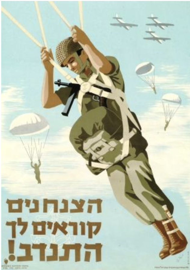
Irgun Poster from the Military Organization of Eretz Israel, beyond Palestine Mandate

–whose decisiveness underlay the cartographic genealogies of ultranationalist thought from the time former Irgun like Menachem Begin entered Israel’s government, advancing advancing gradual annexation by settlers of “lost” lands. The map produced in Central Europe in the post-war period of the 1940s set a territorial goal. If the constitutional silence on territorial borders in Israel’s constitution is invoked as berth preserving the vision of “Greater Israel” in Israeli politics, the ultranationalist ideology of America First ideology invokes an expansive border as a site for federal law enforcement of a “virtual border fence” of Border Patrol’s federal mandate has compromised individual liberties in Donald Trump’s vision of the United States in the Trump era, Likud nourished outwardly expansive borders, as if resurrecting a zombie idea from the dead, but one of deep biblical resonance with the land granted Abraham’s children “from the brook of Egypt to the Euphrates,” accomodating the territorial given to the children of Abraham and Israel over generations to the new language of nations.

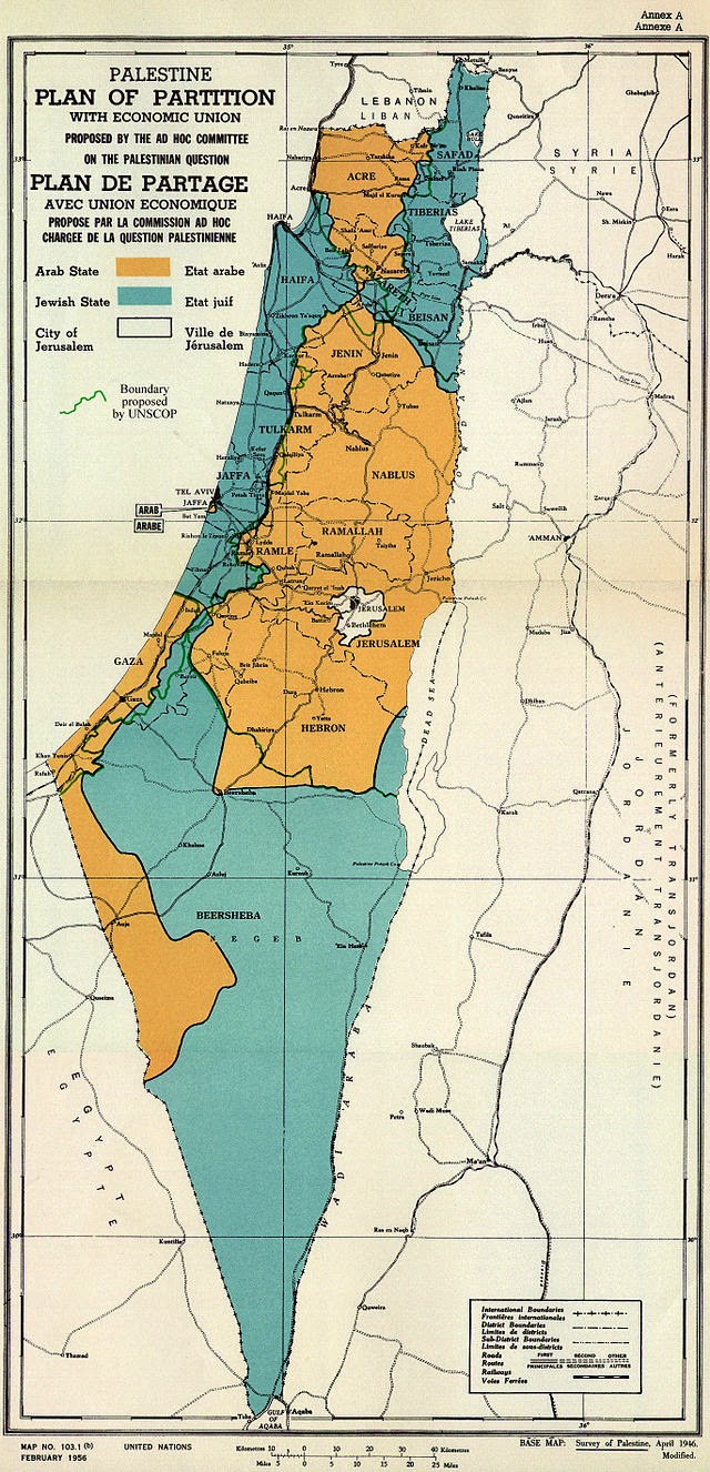
For this map–that places Palestine beyond the borders of Israel, in Lebanon, Jordan, and an “Arab Palestine” to the south of “Eretz Israel” of bright blue hue, that encompasses in its midst the biblical territory of Jerusalem, and the Jordan River, and assumes an almost cloak-like form, in a land map recalls modernist abstract expressionism argues that lands promised to the children of Israel when they left Egypt in Exodus or Deuteronomy offers a template to a modern Israeli state–“two banks the [River] Jordan has./One belongs to us; the other does as well,” read lyrics at its base, redrawing state borders already being negotiated in interwar years.

Greater Israeli from the Nile to the Euphrates, 1947

Which returns us to the telling erasure of a Palestine on the River Jordan’s left bank in the map that Prime Minister Benjamin Netanyahu, Begin’s heir, brought to the United Nations’ General Assembly to make his case While the Democratic presidency is faulted for pursuing a “deal” rather than supporting the future rights of a Palestinian state to exist, there is a stunning amnesia of the promotion of the language of a “deal” in the maps designed and issued in the architect of the Art of the Deal, who set the terms for a “deal” that would given Palestinian territoriality, delimit Palestinian rights, and offer an upper hand to the Israeli state. President Trump’s vaunted “Deal of the Century“ has perhaps been overshadowed by the violence of war, but is a “deal” for which we can find ample fingerprints–and indeed a famous scrawled signature!–among paper maps not only props of statecraft, but frameworks with power to re-shape Middle Eastern politics on the ground. These are maps that echo ultranationalist demands, and echo the forms of ultranationalism that became platforms he articulated in his first Presidential campaign.

As props, these maps–in tiresome ways–demand to be traced as symptoms of the personalization of the political, and indeed the entrenchment of the United States in projects of remapping the Middle East, as much as personalized as a “love affair” between Netanyahu and maps, as Middle East Eye has with accuracy recently observed, noting the “history of using controversial maps” in public presentations to international bodies and the Israeli press, while not fully underlining the personal sanction that the cartographic gifts from President Trump provided Israel’s Prime Minister both to promote his vision of Israel to the world, but a platform to rehabilitate Netanyahu’s political career.

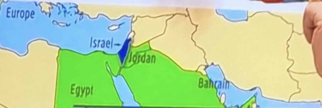
The oddly vivd green-hued map all but eliminated Palestine from the Middle East. The blue island of Israel placed “Palestine” in vivid green nations mapped as Palestinians’ actual homes: “Egypt,” where potentially over 270,000 Palestinians live, Jordan, home to 3.24 million Palestinians, and Saudi Arabia, home to a community of 750,000, and quite vocal as to Palestinian sovereignty–as well s Bahrain, where pro-Palestinian advocacy has been intense among its pluralistic population and Sunni Arabs among the most influential groups–and Sudan, where many Palestinians reside.

The color scheme of the political lay of the land erases Palestinians, perhaps, in a bright blue Israel which lies like a mosaic amidst the clear borders of nations. But the coloration of the political lay of the land is slippery. Such vivid green, long a color symbolizing allegiance to the cousin of the Great Prophet, Ali, gained status since the prophet’s lifetime as a the important color in Islam and the green spirit, Al Khader, and a sign of the vitality of Islam alive from the rich cultural Fatimid era up until the arrival of western crusaders. Netanyahu rose to political prominence, by no coincidence, amidst this improvised patriotic flag-waving in the occupied territories when flying the flag’s colors was forbidden in Gaza, the West Bank, or Golan Heights by Israeli law–provoking the improvised creative display of its colors in laundry hanging outside windows of private residences. If the same flag led the watermelon to become a symbol of resistance, combining the four colors of the flag, the red marker that Netanyahu used before the United Nations to draw a “trade corridor” across an Israel straddling the Mediterranean Sea to River Jordan “map” Palestine outside of Israel’s borders.

Netanayu and ‘The New Middle East’ at 78th session of United Nations General Assembly/September 22 2023 AP/Richard Drew

The vivid light green color of “The New Middle East” that Netanyahu crossed with a red marker was no longer needed to be a theater of war, but could be transformed to one of economic vitality, as if coopting the “green fields” in Safi al-Din al-Hali’s verses Arab nationalists first coopted in the early twentieth century and by 1947 Ba’athists and members of the Arab League took as the national flag of Palestinian people–“White are our deeds, black are our battles,/Green are our fields, red are our swords.” Netanyahu wanted to place these fields securely behind the borders of Jordan, Bahrain, Egypt, and Sudan, not in Israel that lay on a channel of trade to Europe. This quite rebarbative map–as others that Netanyahu brought to the General Assembly of the United Nations from around 2018, and the maps he continued to display through 2023, as if to make the case Israel demanded to be seen as a “normal nation” among nations. But increasingly it may indeed seem to conceal it is not–indeed, Palestinian residents in Israel are not deserving of any clear political role in the New Middle East.

Netanyahu Addresses General Assembly from UNGA Lectern September 22, 2023/AP/Mary Altaffer

The geopolitical situation as he spoke was extremely complex, but the presence of Palestine was masked in mapping Israel by a blue island by the River Jordan held before the General Assembly, in ways oddly incongruous with the image of global peace on the lectern from which he spoke. The map clearly showed a West Bank and Gaza under Israeli control, even though the situation on the ground as he spoke was one of fragmentary political control by both Hamas in Gaza and Fatah in the Jordan Valley, largely subject to the “supervision” of Israel’s government. The complex administration of the areas of Fatah control in the West Bank and Jordan Valley contrast to muted blue areas jointly administered by Fatah and the Israeli military, and a light green sea of Israeli military control surrounding the lands of settlers in the Jordan Valley If the blue regions were subject to joint administration by Fatah and the Israeli army, light green showing areas of Israeli military control, rather than administration by a civil government, the airspace of the entire region was administered by Israel, but the entire region not controlled by any means by an Israeli state.

Evan Centanni, Administration of Land October 6, 2023,/reproduced by permission of Political Geography Now. Sources: B’Tselem, UN, Gisha, city population.de

Why was such a mixed administration around areas of Fatah control masked before the General Assembly? Was this intended to normalize the Israeli control over a mythic “Greater Israel” or was it just a map? The map Netanyahu held proudly of The New Middle East as if teaching a class without familiarity with world affairs. It was a sort of magic trick as much as informative, and masked actual bounds. It successfully concealed the violence of apartheid relations, on the one hand, and erased historical Palestinian demands, simplifying history immediately raised eyebrows by rendering a “New Middle East.” The map that the Prime Minister brought to New York while his generals planned the invasion of Lebanon was reflecting back at Americans a recognizable coinage of then Secretary of State Condoleezza Rice, who in late July 2006 had vouched during an earlier invasion of Lebanon with American arms–and just before the United States invasion of Iraq–the bombing campaign focussed on freeing Lebanon of Hezbollah that targeted terrorists with unprecedented force marked “the birth pangs of a New Middle East” able to accelerate a “freedom and democracy agenda,” rather than one of dislocation and destabilization. Secretary Rice had promised a “domino democratization” across the Middle East would result from assisting these “birth pangs” by “pushing forward to the new Middle East, not going back to the old one.”

Secretary Rice invoked the groundless discredited rhetoric of “dominoes,” not as about to fall to communism but as an extension of a “green revolution” in Arab states that would alter the geopolitics of the Middle East in definitive ways to the benefits of Americans. Armed with these persuasive tools, Rice cast extirpating Hezbollah not as violence but as a “moment of opportunity,” advocating the chance to intervene decisively to remap the geopolitical center in the Middle East among Egypt, Jordan, and Saudi Arabia during the war between Israel and Hezbollah–in place of the “old Arab center,” and leaving the question of the future of Palestine off of the political map, remapping the Middle East from afar for American eyes. Indeed, the affirmation of Jerusalem, a divided city with a large Palestinian presence in the East, which Israel considers critical to its territorial integrity as a capital, was surrounded by light green territory under Israeli military jurisdiction, beside a mosaic of light blue regions jointly administered by the army and Fatah.

Territorial Administration around Jerusalem, August 2023/Evan Centanni, detail of above

In ways that obscured this complex balance of shared authority and jurisdiction, the map of “the New Middle East” Netanyahu presented was not a return to the rhetoric of George W. Bush, but refracted through the hardball politics of redrawing of boundaries encouraged by Donald Trump. Was not the map of Jordan, Bahrain, Egypt, and Saudi Arabia but an updated version of that hope? Netanyahu may have implicitly told the United Nations that Israel, extending from the Mediterranean waters to the River Jordan, was already surrounded by states of Palestinian populations–that Palestinians, in other words, who often designated themselves by light green, had “their” states already. The Palestinian flag of white, green, and red, prominently included green to designate the survival of nationhood of which medieval poet Safi al-Din al-H’ly rendered an icon of three colors–“White are our deeds, black the fields of battle, our pastures are green, but our swords are red with the blood of our enemy.”

The tricolor was proscribed from flying in Palestinian lands– Gaza, the West Bank, and Golan Heights–for the generation,1967-1993, as Netanyahu rose to political power in Likud; the cartographic symbology seemed coopted in the map Netanyahu conspicuously displayed at the United Nations, placing Palestinian pastures beyond Israel’s borders. In the “New Middle East,” Israel possessed the Golan Heights and lands of the West Bank, the reduced Greater Israel is far more limited scope than Jabotinsky’s vision, but integrated in a community of nations–imagining a new “security envelope” that expanded Israel’s territoriality to the West Bank.

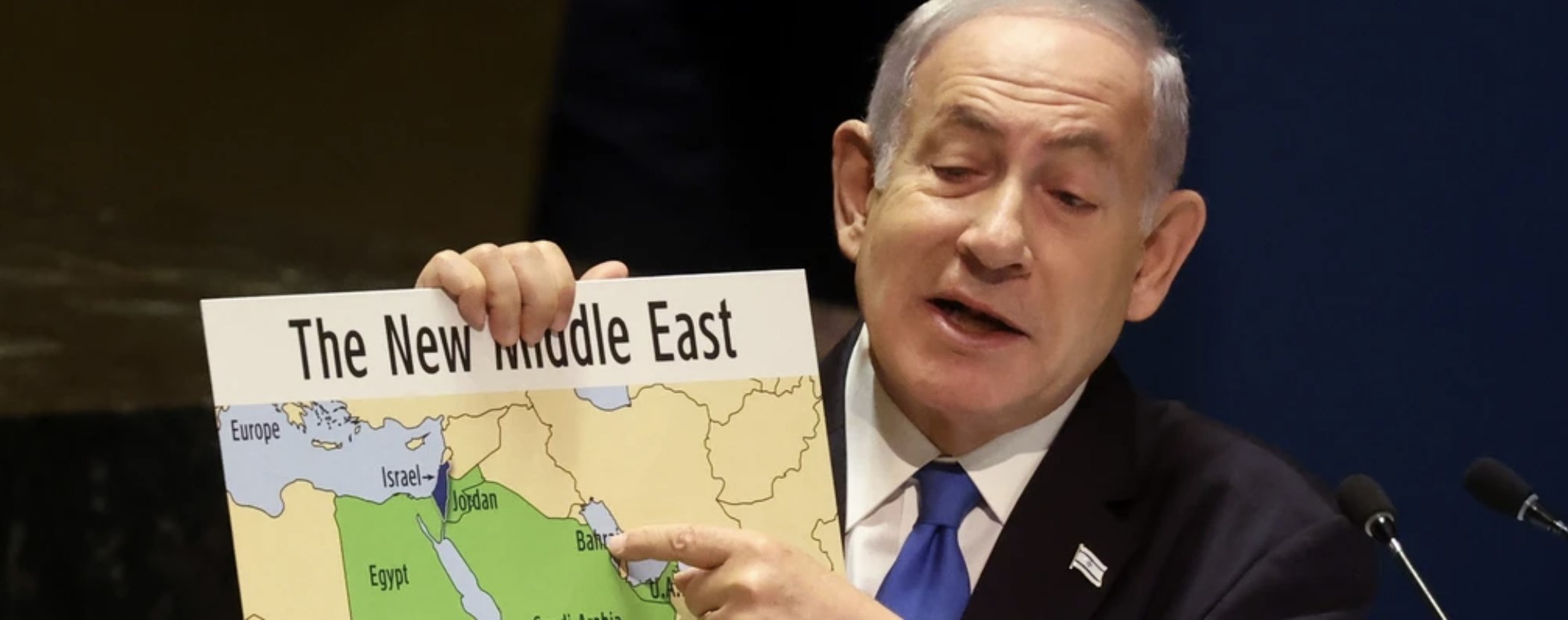
Map of “The New Middle East” Netanyahu Prominently Displayed to Address General Assembly Sept. 22, 2023/ Spencer Platt/AP

The Israeli Prime Minister was using the map to demonstrate a world view, more than a regional map. No map is all-seeing, objective, or all-knowing, but maps shape reality as knowledge-making systems: the powerful map green seemed to illustrate an Israeli state surrounded by the Palestinians with which Israel could live. The security of such secure bounds was a creation of the Trump presidency, but we may have forgot how keenly Trump fed that new map of the Middle East to Netanyahu in transactional exchanges to maintain his political survival, navigate a future with far right-wing allies, and win a second term. A sort of “Dance of Death” had indeed emerged between this remapping and remaking of the Middle East in the Trump Presidency, that used maps to redefine reality, and indeed maps to redesign political boundaries from an increased removed from the ground. Yet the situation was quite different, PolGeo reminds us, on the ground.

Administration of West Bank October 6, 2023, Evan Centanni/used with kind permission of Political Geography

The map of a Greater Israel became a sacred icon for the new hardball politics of the Middle East parallel how Trump employed crude maps of the US-Mexico border maps to advance the populist politics of a nationalist movement. In the map Netanyahu used to address a mostly empty halls of the General Assembly in late September 2023, Lebanon was notably not marked as a nation. As the map showing the boundaries of Israel after the first Arab-Israeli War in 1948 Netanyahu displayed incorporated the West Bank, as if to erase history, the “New Middle East” resuscitated the ultranationalist vision of an Eretz Yisrael— a “Greater Israel” including the West Bank and Golan Heights. The “map” was in fact less a nation than a concept of a nation, but the ultra-nationalist older right wing Zionist conceit quashed any idea of negotiating about a Palestinian state.

The expanded territory of Israel symbolically expelled the 1.7 million Palestinian residents of Gaza–before the October 7 invasion, retaking the ancient “territories” of Judea and Samaria, west of Jerusalem, to use the scriptural place-names of ancient biblical Kingdoms–as if those were the true territories the nation of Israel was historically destined to include. Entrusting an army of settlers to annex over future generations lands claimed as lying within Israeli territory seems to naturalize a territoriality by a map of transhistorical verities, rather than of political process or human rights.

“The New Middle East” Netanyahu Displayed at U.N. General Assembly on September 22, 2023, detail

Netanyahu’s notorious use of maps noting “military control” of Gaza’s borders by Israeli forces, like the these maps that extended Israeli territory to the West Bank, make offensive arguments of silence by erasure. They offer templates for failing to recognize Palestinian presence. If Zionist groups had earlier at times claimed the Transjordan, or historical Mandate, to imagine an expansive ‘Greater Israel”, the Likud Party set its sights on settling the West Bank, and even resettling a Greater Israel that included the Gaza Strip and Golan Heights–a far right conceit that extended beyond Israeli borders to the Transjordan and Sinai Peninsula, its capital in an undivided Jerusalem. As much as geopolitical intentions were ascribed to Israel of territorial ambitions to settle the region from the Nile to Euphrates, little different from how the Israeli flag was allegedly interpreted by leaders of Hamas as the “map” of a region extending from the Nile to Euphrates that included Jerusalem at its center, as claiming territory from the Mediterranean to the Jordan.

The actual proposals for securitized corridors around Gaza bounded Palestinians outside Greater Israel, after the armed reprisals for Hamas’ invasion of Israel, dismantling Hamas’ presence in the region and policing the boundary between Egypt and the Gaza Strip under Israeli control in future years, so that it is residents are entirely bordered and contained by Israeli military authorities. The demand to block what Israel treats as a dangerously transnational space–the very route by which arms, weapons, and bombs entered along the only remaining corridor of Gaza to the outside world–is cast as an objective of the Gaza War, demanding control of a narrow space lest it continue to provide “oxygen” for Hamas in the Gaza Strip., as if the border crossing Israelis have held since May provides a sort of tourniquet and security envelope for the future. Is the image of protective corridors not a Trumpist vision of space of a militarized border zone?

 “Philadelphi Corridor under Israeli Military Control”/Ohad Zwigenberg (AP)/September 2, 2024

But the use of these maps to normalize aggression–perhaps even raising questions of a future Israeli settlement of Gaza that has recently emerged as a far-right agenda–provoke and enrage only since October 7, 2023. The truly mythic geography that placed Jerusalem at the center of a “Greater Israel” could not but include the mythic, biblical kingdoms of Judea and Samaria–not on any actual political maps, but nourished in ultra right-wing Zionist political rhetoric and increasingly close to platforms of Likud. The recognition of Jerusalem as a capital of Israel early in Trump’s presidency responded to an old demand that the divided city be recognized as a national capitol. In announcing a decision to place the American Embassy in Jerusalem from he White House had sent shock waves around the Middle East. For he seemed consciously to recognize and proclaim a new order of American foreign relations in 2017, by announcing in a news conference “Today we finally acknowledge the obvious: that Jerusalem is Israel’s capital” as “nothing more or less than a recognition of a reality.” But no map, of course, is ever merely a reflection; as much as a recognition, maps offer a shaping of reality.

The map that officially designated Jerusalem as Israel’s capital–long a demand of the Israeli state that American governments resisted–was an affront to allies across the Middle East, and remaking of decades of rather delicate foreign policy, opening fault lines between Palestinians and Israelis, and making the United States an outlier among nations–even as Trump deceptively cast it as “a long overdue step to advance the Peace Process,”– even as he recognized having rocked the international boat while appealing to “calm, . . . moderation, and for the voices of tolerance to prevail over the purveyors of hate.” By November 17, the United Nations, over American opposition, declared void any action by Israel to impose its laws, jurisdiction, and governance over Jerusalem as “illegal and therefore null,” invalidating all authority of the “occupying power” and demanding withdrawal from Occupied Territories. Netanyahu responded by the bluntly drawn borders of a counter-map.

American Shift of U.S. Embassy to Jerusalem, Lending Recognition to Israel’s Declared Capital City/NY Times

Who were the “purveyors of hate” but the Palestinian people? The maps that were provided by the Office of the Geographer of the United States of the future “State of Israel” in the Middle East curtail hopes for a Palestinian state, if not provide grounds for the disarming arrogance with which Israeli right-wing forces seem to have adopted an open policy refuting the right of Palestinian settlements or states as it situated the U.S. Embassy in Jerusalem, only recognized as the Israeli capital as President Trump single-handedly issued a Presidential proclamation in 2017, shortly after his election, ordering relocating the embassy be situated in Jerusalem, to the glee of Prime Minister Netanyahu, who won a sort of prize from the United States in official placement of a five-pointed star designating a capital in a city that sparked such sudden protests across the Middle East in early December, 2017, the United Nations Security Council immediately condemned the proclamation as destabilizing of any peace process in early December 2017.

Trump saw the early declaration of a new site for the embassy as purely “transactional” more than political or ideological–“today, I am delivering!”— fulfilling a campaign promise he long ago made the late Jewish American financier Sheldon Adelson, who with his Israeli-born wife made it a hobby of vanity to meddle in Israeli politics and media. Trump wanted to recognize Jerusalem as Israel’s capital, he argued, before the Israeli-Palestinian conflict was resolved, echoing Sheldon and Miriam Adelson’s intense opposition to a two-state solution from 2017. The opposition grew into an agenda for the Israeli-American Council political lobbying group, arguing against history “the Palestinians are an invented people” to promote the right of return of diasporic Jews to Israel–promoting the Birthright Foundation with a half a billion dollars of their fortune to take Jews from across the world to visit the Holy Land to strengthen ties to Israel. By inverting Jews’ historic expulsion from the Roman Empire’s borders forbade Jews led to settle the expanded boundaries: whereas Romans forbade Jews to settle in Jerusalem or Palestine, the call of return inverted the wrongful diaspora created after wrongful blame for Hadrian’s death, the expulsion from the Empire’s borders ca. 133, effecting a “return” from the Empire’s edges in Egypt, Babylon, Italy, Spain, Eastern Africa or India.

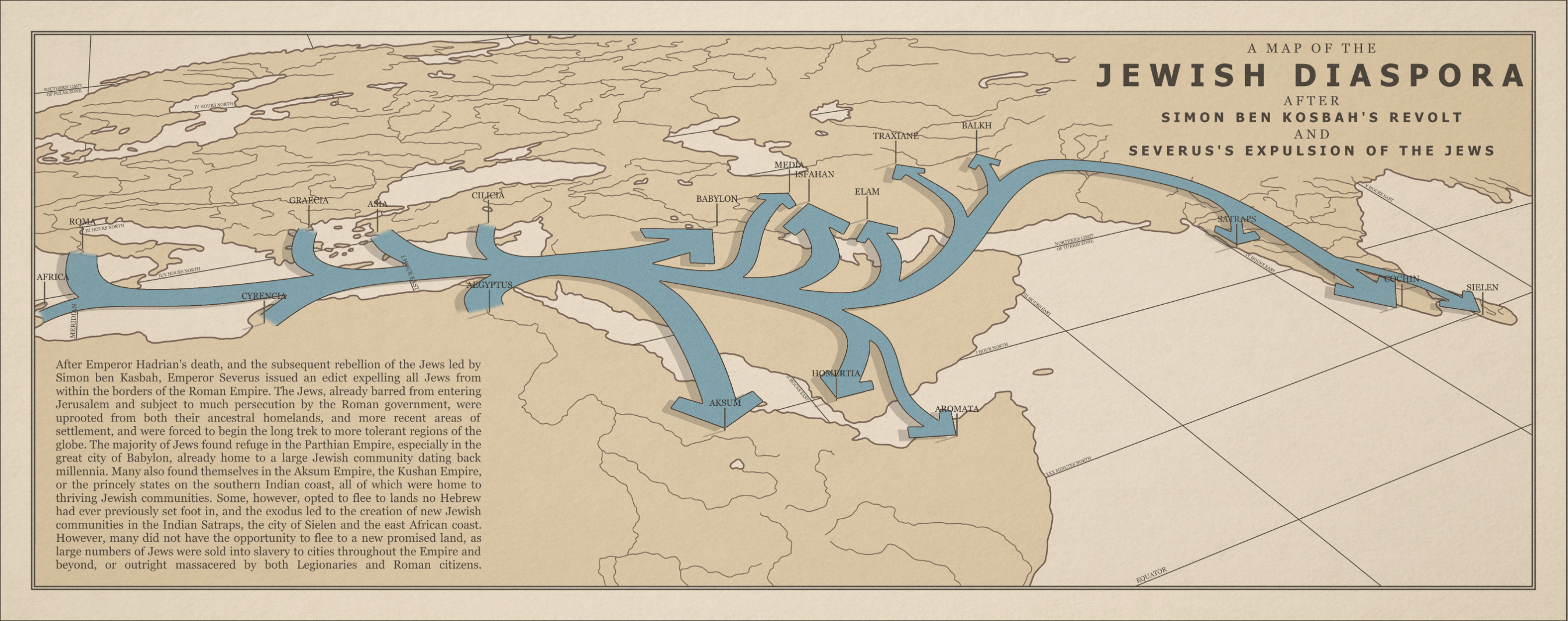
Imagined Trauma of c. 130 AD Jewish Diaspora from Severus’ Expulsion of the Jews from the Roman Empire/ Radioactive_Bee/r/imaginarymaps

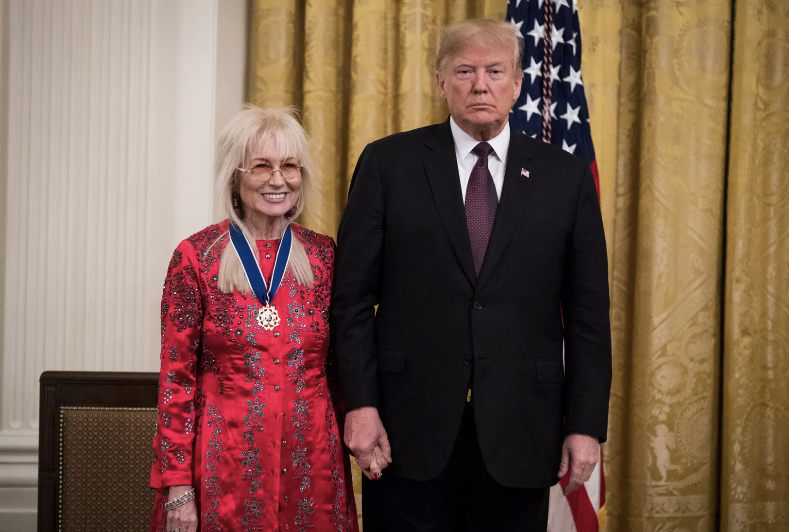
Miriam Adelson, a megadonor to Trump’s 2024 Presidential campaign, donated a sum second only to Timothy Mellon and Elon Musk, over $106.8 million, five times what her husband contributed in 2016, and has courted billionaires to support Trump’s White House bid. Her award of the Medal of Freedom in 2018 confirmed her role as a kingmaker of sorts, and she attracted a hundred donors to her own SuperPAC to swamp the airwaves of battleground states, convincing WhatsApp founder Jan Koum to add a five million dollar contribution. Her auditions of Republican candidates in Las Vegas became a litmus test that fed Trump’sinitial expectation that Trump she was good for $250 million in 2024–she aimed to drum up the support as Trump made it clear he demanded from mega donors to appreciate the strings he could pull after his return to office, reminding them repeatedly how much they had to be grateful for for tax reductionss, militaRY support and defense of Israel’s expansive boundaries, even after the Gaza War, alternating assurances over cozy candlelight dinners at Mar-a-Lago and text messages angrily demands donations to his campaign through Election Day to expand his support for moving the American consulate to Jerusalem, for which the late Sheldon Adelson had long mobilized support, provoking Miriam Adelson to demand Trump support an official annexation of the West Bank and deny all possibility of a Palestinian state. Critics of the Israeli counter-offensive in Gaza “are dead to us,” Adelson ominously warned; Adelson promoted not only Micke Huckabee for ambassador and Elise Stefaniak at the United Nations.

The myth of expulsion was mapped in the didactic style of an old schoolbook is fictional despite its authoritative arrows, the infographic attracted attention on reddit; it might be an icon of a diasporic imagination. Tracing the imagined consequences of a ban from the Roman empire’s borders after the Bar Kochba revolt, it embodis the mythic diaspora that Zionism seeks to reverse–a reversal invoked in the mythic geography as a basis to demand that Israeli law be applied to the fictional regions of Judea and Samaria–regions Israeli settlers have increasingly occupied, demanding military protection, that led to Likud demands to reject international law designating ‘Judea’ and ‘Samaria’ as “occupied territory.” This wanton elision of international law was basis for a roll-out of the “Trump Deal,” expanding a “Greater Israel” outside Israeli borders, a flouting of international agreements that must be placed in the chronology of current understandings of the Gaza War. The erasure of international law that was adopted in the Likud platform included a “right of settlement,” that continues to animate the current calls of right-wing ministers to “settle Gaza” and encourage Palestinian migration as a restoration of a “Land of Israel” as if it could be imagined as “the most ethical” solution to the currently devastating war, mirroring calls to settle the West Bank. The fears of actual threats of “rocket strikes” from Judea and Samaria have mobilized fears about the regions–the presence of settlers argued to prevent rocket strikes on Israel’s unsecured borders, as Israeli withdrawal from Gaza led Palestinians to fire Katuyusha rockets to Israel.

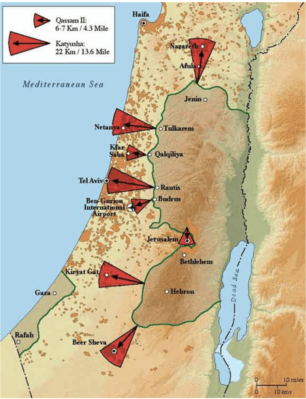
Map of the Rocket Threat from Judea & Samaria to Israel (2020)/Endowment of Middle East Truth

The fear of transforming Judea and Samaria to a grounds for staging a terrorist attacks on Jerusalem, Nazareth, Beer Sheva, and Tel Aviv makes the “green lines” of this map of rocket threats leap to prominence, and demand the protection of settlers’ de facto annexation of the West Bank.

The securing of a “Greater Israel” is impossible to separate from the designation of Jerusalem as the capital. Trump’s recognition of Jerusalem as a capital was an insult to hopes to secure East Jerusalem as the capital of a Palestinian State were placed on ice, even if Trump’s Texan Secretary of State, Rex Tillerson, sought some conciliation in statements that the move “did not indicate any final status of Jerusalem” and “that the final status, including the borders, would be left to the two parties to negotiate and decide.” Despite such ample acknowledgement of some form of future agency, apparently betraying a lack of attention to details as actual borders, the interest in determining new borders–and defensible borders–were promoted in the “deals” to animate a promised “peace plan” resolve longstanding Palestinian-Israeli conflict, entrusted to the 38- year old apprentice, Jared Kushner, the son of the wealth realtor and son-in-law of the President, promising varied economic plans and proposals and touring six capitals, in a week-long trip of Middle Eastern countries, even after the Palestinian Authority preemptively had rejected any United States proposal after the affront of relocating the embassy to Jerusalem–long the center claims and counterclaims to the sacred center of any two-state solution, and the site of the division since Israel’s founding in the 1948 Arab-Israeli War, long sectored by different temporal authority,–

— but unilaterally annexed since 1980, when Israel declared its capital, even if Palestinians make up close to 40% of its current population, and the city is divided in East and West, and bisected by a complicated curving wall, check-points, and gates manned by soldiers, increasingly to protect enclaves of Israeli settlements in East Jerusalem.

[Chart]

Boundaries featured, unsurpisingly, fashioned in simplistic, arrogant, and insulting terms in the different iterations of the Trump Plan, hardly led clarity to the islands of Palestinian population, but created a “green entity” linked by roads, and tied to the River Jordan, while offering Israel control over the West Bank, and being presented as a concession that allowed the fiction of an Israel that stretched from “The River to The Sea,” if one accepted the map’s general design. If the kingdom of Judea existed in the 9th Century BCE, to one side of the Jordan from the Ammonites and the Moabites, the historical populations of an ancient Kingdom of Israel was able to be mobilized, as the ancient Temple Mount in the Old City remained very much at the center of territorial dispute.

The Trump Plan proclaimed a resolution of Israeli-Palestinian differences with bluster as the first “plan” to be put on the table and have multiple signatories–save Palestinians, that is, whose arms were seeming to be twisted to gain approval through a broader international consensus and economic carrots to promote the far bleak futures of impoverished residents in a Gaza Strip, but required no Israeli concessions. The map granted single isolated port city for Palestinians, was premised on drilling an underground Gaza-West Bank Tunnel (!) linking Gaza to the Palestinian enclaves lying at a remove west of the River Jordan, suggested a massive remaking of Israeli state’s position of strength in the Middle East, and victory of absolute recognition of Israel’s right to exist from Palestinians–the map was a map that would guarantee recognition of Israeli boundaries, rather than a Palestinian land.

The promises that the Palestinian economy might be boosted by planned residential, agricultural, and industrial communities way to the south of Rafah, if an acknowledgement that few fertile lands would be in the reduced Gaza Strip, would be oddly placed at a remove in the Negev, linked by thin roads or causeways along the border with Egypt, fragmenting the Palestinian presence.

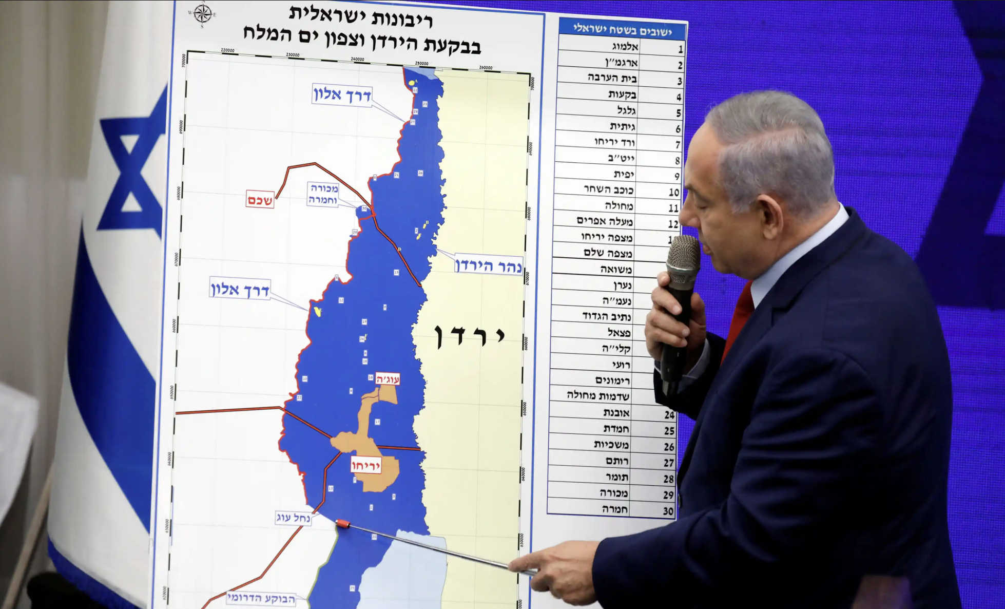
But the closest appearance of Trump’s figurer prints lay on “the new official U.S. map of Israel” that Trump personally allowed Kushner to give to Prime Minister Netanyahu, as a promise to be in his court, in his February 2019 trip by the apprentice Kushner, the thirty-eight year old son-in-law Trump had placed in charge of the deal he called a “peace process’ that at last recognized the Golan Heights–a site of the current war between Hezbollah and Israel–as Israeli territory. This map set a powerful precedent of similar international precedence essentially recognizing lands occupied since 1967, and annexed to Israeli territory in 1981, removing what the rest of the world recognized as Syrian territory that the Israeli army had occupied, as part of Israel’s sovereign grounds. Indeed, the “plan” registered a severe and unidirectional loss of Palestinian lands that Al Jazeera was quick to note, removing lands form Palestinian sovereignty to make the Oslo Accords look like the good old days, shrinking land under Palestinian control away from the West Bank and limiting jurisdictions.

If the firing of many Hezbollah rockets into “Israel” were target at the Golan Heights in recent months, the unusual map presented Netanyahu two weeks before what would be his reelection became a slap on the back and endorsement, labeling Israel’s annexation “Nice! Recognizing the reality of what were deeply contested boundaries as straight lines, Trump took to what was then Twitter to tweet he was “hoping things will work out with Israel’s coalition formation and Bibi and I can continue to make the alliance between America and Israel stronger than ever. A lot more to do!” The recognition of Israeli sovereignty over the Golan Heights had been formally recognized on the visit of Netanyahu  to the White House in an earlier proclamation of March 25 confirming Israel’s ability to “protect itself from Syria and other regional threats” in defending the Golan Heights–a move of chess of fundamental import in the current war against Hezbollah and invasion of Southern Lebanon by the Israeli army. The arrival of Kushner with the map in April, just before the Israeli elections, led him in May to showcase the “update[d]” map as the basis for the Trump ‘Peace’ Plan.

The proclamation asserted a deep commitment of the United States to the acknowledgment “any future peace agreement in the region must account for Israel’s need to protect itself from Syria and other regional threats,” not naming non-state actors but giving backing and carte blanche to the Israeli leader to defend enhanced boundaries of the state. When the map was displayed by Netanyahu at t press conference, he crowed “Here is the signature of Trump, and he writes ‘nice.’ I say, ‘very nice!'”–as if delighted with the new objective truth and framework the map set forth.

The sentiments were reprised in Kushner’s late May public statement stating “The security of Israel is something that’s critical to the relations between America and Israel, and also very important to the President, and we appreciate all your efforts to strengthen the relationship between our two countries;” Prime Minister Netanuyahu happily stated Israel’s relation with America had “never been stronger, and we’re very excited about all the potential that lies ahead . . . for the future.” The powers of prognostication were in a sense supported and formalized but he

May 30, 2019Thomas Coex/AFP

The election of April, 2019 was hardly a massive victory for Netanyahu, if it meant a fifth term. His political party won a mere 35 of 120 parliamentary seats, but it placed him in a new alliance with the far-right parties that had been engineered by the cartographic gifts that Trump had provided the Prime Minister became props for a new form of political theater with which Netanyahu was particularly taken. The map was a gift that kept on giving, a new knowledge system to deploy the firmed up boundaries of the Israeli nation that no other nations would recognize save the United States. Even if it was not a recognition of “reality,” the flouting of international consensus offered Netanyahu a needed shot, a show of support for the defense of current expansive borders, and even support of the arrogance of drawing borders,–as if the “Geographer of the United States,” Lee Schwartz might take up a larger role in the State Department, where his office was in fact located.

This map was the gift that kept on giving, a showpiece of sorts that preceded the many maps that Netanyahu quite triumphantly brought to the United Nations, maps that set the precedents for the maps Netanyahu brought to the United Nations General Assembly to lecture the world on the possibilities for peace in a New Middle East, in which Israel controlled the full West Bank–a map he had displayed before the April election on Israeli national television, and the map where Gaza was shown to be part of Israel, absorbed in an attempt to focus on the international alliances that Israel was announcing, the small details of Palestinians’s hopes for territoriality were dwarfed by the fantasy of a new community of nations–that led to campaign promises to incorporate the West Bank to affirm an expanded Jerusalem at the center of the Israeli nation, reaffirming in “blue” the territory of a united Jerusalem that was nestled right up to Jordan in the 2019 election. The map was a political promise to expand Israeli territory in the West Bank he insinuated the Trump Plan would allow him to annex in the Jordan Valley, due to his close relation to the American President.

The speech before the 2019 elections promised “Peace and Security” as if citing Revelations 19:20, at time when the contents of the Trump Plan were not yet fully known, and the power of suggesting a major remapping of the relation of Israel to the West Bank might be persuasively made. The map, whose logic seems to underlie the claims of the map of the “New Middle East” Netanyahu would use before the General Assembly, on September 23, 2023, just weeks before the October 7 invasion. Indeed, the image of an annexed West Bank suggests a negative image of the invasion of Gaza, or make Jericho, as Youse Munayyer, the Director of the U.S. Campaign for Palestinian Rights put it quite succinctly, leave Palestinian residents of Jericho dependent on Israeli authority to enter and exit what would be a “new Gaza, another open-air prison Israel can lock down as it pleases.” The desired transformation of almost a quarter of the West Bank by the wave of a magic wand into an area of Israeli control area would disenfranchise Palestinian residents who would lack all voting rights or citizenship, but live in a system of limited autonomy might be better called apartheid, controlled by a minority of Israeli Jews.

Menahem Kahana/AFP

What Netanyahu boasted was a “dramatic” plan and opportunity for fragmenting Palestinian communities within Israel was hardly a “deal” acceptable to Palestinians, and prevent a future Palestine, annexing a quarter of the occupied territories. Describing the option as able to be realized by virtue of his privileged relation to Trump, he openly appealed to far right parties: by calling the Trump Plan “visionary” in scope, he offered the vision of a containment of Palestinian hopes for sovereignty in an Israeli state that was in fact recycled form a 1968 plan for a divided West Bank that annexed rural Jewish settlements to an expanded Israel, while allowing enclaves of Palestinian communities around Jenin, Nablus, Ramallah, and Hebron to formalize ties to Jordan.

Netanyahu Hints Trump Plan Will Let Israel Annex Key Land

Netanyahu’s 2019 Proposed Annexation of West Bank and Confinement of Palestinian Civilian inhabitants

But if Netanyahu spun fantasies of new borders and expanded Israel out of maps, this post is about the fate of the Trump maps. For the presentation of that map–and the map of a peace proposal that demanded no sacrifices of land for Israel–seems the tipping point of sort. The maps played a large role that provided Netanyahu with the credibility of a statesman in Israeli national elections, a gift allowing Netanyahu to claim control over territory that Israel had not won recognition by the rest of the world. When Netanyahu displayed the personally signed map to the nation in a news conference, even if he failed to assemble the coalition needed to gain a second term, the Prime Minister used the maps s prop to affirm his ability to navigate the nation to the future defense of its borders and boundary lines by his personal ties to the United States President, a gift of statecraft that materialized boundaries of a newly expansive sort as if they were a true consensus. Displaying the map helped his foreign policy expertise to be leveraged for a new term. He quite quickly invited Americans to visit the new Israeli town he in northwestern Golan to found in Trump’s name to acknowledge the meaningful nature of geographic recognition of the Golan plateaux under Israeli sovereignty, voyaging to the region to celebrate Passover as part of a “thank you” for the gift of an American president who “recognized Israeli sovereignty over the Golan Heights forever,” declaring the foundation of a new permanent village be named after the former American President.

Was the gift of the map that Kushner was entrusted not the basis for the forging of a new personal friendship of transactional sorts that Trump was able to present Netanyahu as a promise to stand behind the Israeli Prime Minister’s illusions of protecting Israel’s greater borders, to protect its security? The United States Geographer Lee Schwartz, who signed the map that Trump entrusted Kushner, lists his remit as “defining detailed and advise policy makers on territorial disputes to aid international boundary negotiation may have gone above and beyond his role to offer “guidance” on the ways boundaries are shown on government maps, to adjudicate and resolve international disputes, as Schwartz had in Kosovo and the Baltics, and to guide the Office of the Geographer and Global Issues–a weighty title, not to suggest that folks at the office didn’t also have fun with maps.

Dr. Lee Schwartz with INR/GGI Team at the Office of the Geographer on Global Issues, 2019/Isaac D. Pacheco

The office of Geographer had evolved in a global context after the Cold War to endorse claims of sovereignty and international boundaries to federal agencies became a platform of sorts to curtail the advantage of redrawing boundaries, as well as determining problematic questions of naming, even adjudicating maritime boundaries that addressed “global issues” analytically from an office within the Department of State. Haing taught at American University in Washington, DC, with a background in the Cold War, Schwartz was soon recruited at the State Dept. to work in the office of regional analysis, specializing in refugee affairs.

Stream episode Lee Schwartz: The Coolest Geographer You'll Ever Meet by US  Embassy South Africa podcast | Listen online for free on SoundCloud

The drawing of boundary lines recognized by the U.S. Office of the Geographer were trusted as “holding up in court cases.” The Office used s “compelling evidence” to map states in the Balkans, that were seen as far more compelling than satellite views. But the maps of Israel’s expanded sovereign bounds launched a missile at the heart of Hezbollah and of Palestinian claims to the region, providing “legal” validation of Israeli territoriality anticipating Israel’s legal rights to territory above any other nation, offering legal validation of the expansion of Israel’s frontier outside the United Nations or international community. Which makes the speeches Netanyahu delivered all the more frustrating. For his cajoling of the United Nations General Assembly to “go along” with new maps in future years played fast and loose with the shifting toponymy of a country much as Trump’s unilateral shifting of the United States Embassy to Jerusalem. The recognition of Israel’s capital as Jerusalem led to the renaming of a small square in Jerusalem beside the embassy’s new location after the United States President, nominally in recognition for his having the courage to “stand on the side of historical truth and do the right thing”–coopting the phrase in an act of pretty radical historical revisionism, eliding the sacred and the secular and echoing biblical geography for his American fundamentalist audience. Trump may not be personally invested in a Christian Zionist vision; but he has cultivated religion as a critical constituent in the marketplace of ideas as a valuable investment. For Trump, the sacred rhetoric easily bled into the image of a strongman. It was fitting Trump concluded his campaign by arrogantly assuring audiences should God “come down and be the vote-counter for just one day,” Trump would win decisively states with immigrant populations–he singled out my blue state of California–by excluding illegitimate votes.

For a strongman who has advantageously coopted agendas, cobbling together religion and apocalypse provided vast reservoirs of hyperbole in Donald Trump’s political imaginary. The survival of a sacred image of Israel has gained an untold and terrifying prominence in the American imagination, not of Puritanism, or of a nation in the wilderness, but of of apocalyptic meaning, as Trump himself assumes a near-biblical prominence as a prophet in the MAGA world who is able to claim a historical destiny not only for Israel, indeed, but, by way of extension into the notion of a sacred nation of America, within the ultranationalist imagination. In this imaginary, territoriality of scriptural sanction bears a close family resemblance to the fundamentalist insistence on borders over rights, and of near-divine sanction, in the promotion of the southern border of the United States as it is promoted with a near-apocalyptic vein and verve. While the same twill cap retails on Etsy for $29.99, it opened a view on a mental geography I was quite surprised to see in the Sierras offered a window into how Christian Zionist imaginary invested the geopolitics of the Middle East with prophetic meaning. Tapping an evangelical strain I associated more with Mike Pence, the cap seemed an artifact of globalization, hardly out of place in Ace hardware store in Nevada stocked with objects made in China. But it provided a vividly sense of the access to Middle Eastern politics the Trump campaign promised that I hadn’t ever appreciated with such sudden and direct impact.

The year 5785 that began at sunset on October 2, 2024 places Trump’s Presidential campaign in a calendar not of the secular world but from creation, by God’s calendar, beyond any political cycle or national calendar. The year end of times destruction may be the conclusion, revealed in the Hebrew letters of Trump’s name on a cap fit for a coming apocalypse, more than any election, seemingly signed by the signature of the very same executive proclamation that recognized Jerusalem as Israel’s national capitol, and cemented Trump’s symbolic ties to a Holy Land. The headgear that was in fact widely available online was no doubt not made in America, but was an ideology whose eschatological implications sent my head spinning as I was preparing to canvass voters who might be eager to support a ticket that was ready to promise it was zealous to acclerate Armageddon, and eager to promote a sense that the proverbial prophetic writing was indeed already on the wall.

Hebrew Hipster ships the RUMP VANCE 24 (2024) in Hebrew Embroidered Baseball Dad Hat from California

Hebrew hipster ships the MAGA kippa, needless to say, as well as MAGA twill caps, for the faithful.

But if the Jewish electorate or “vote” is important, the evangelical may be as critical. For the cap remained me how much the end times teleology of Christian Zionism was apt to link the current election to a date ready to be remembered by the Jewish calendar from creation. The awakening of 5785 suggest a deliverance and spiritual rebirth that is provided only a candidate inspired by the breath of God, no matter what events are occurring in the world: if 2020 was a season marked by a lack of faith, the coming year would bring a final revelation of God’s word, to combat the Moabites, Ammonites, and the proud people of Mt. Seir attacking the nation of Judah, for Israel to occupy the restoration of its full territory in the year when Israel and America will, per Christian Zionism, also recover territory the enemy had wrongly entered as the entire nation will come to repent–and by Psalm 85, in order to restore divine favor to the land–lest abortion, same-sex marriage, trespassing against one’s created identity, and absence of prayer inspire God’s Old Testament wrath. Let us heal our land in the first forty days of the Jewish New Year, lest it be destroyed by his fire.

Ace Hardware, NV

A semiotic decoding of the hat, so overdetermined in its Hebrew lettering and Old Testament associations, is challenging, so cluttered is it with symbolic paraphernalia, accumulated symbolic identities of faith, nation, and masculinity to resist interpretation, subsumed in combination of Old Testament faith and Christian apocalypse, save as an announcement of destiny to prepare for the awaiting of the Rapture. It proclaims that the faith of “proud deplorables” intersect with a vision of Trump-as-biblical-prophet of apocalypse whose time has indeed come in America, even if it may begin in the calendar of Hebrew scripture.

In proselytizing a candidate for the American Presidency in black Hebrew letters date the campaign from the creation of the world, the salesman I met while canvassing was promoting a cult of personality as a prophecy destined to inaugurate a new historical era more than a President. Even in a store selling goods mostly produced overseas, the largest proportion probably in China, the cap reminds us to place Trump’s candidacy in a global context, as much as one of Making America Great Again, transposed from a medieval universal history culminating in the Apocalypse, which resonated strongly with the Fundamentalist origins of placing the capitol of Israel back in Jerusalem. While I was in the state to encourage voting, I didn’t need to reflect much how the prophetic vein was bound to elicit votes far more effectively than an army of door-knocking volunteers. Could it be that in the current United States, apocalyptic rhetoric has become the ultimate strategy of getting out the vote? In affirming right-wing Zionist Israelis hopes to restore God-given borders of sacrosanct nature, mutatis mutandi, the logic of territoriality was doubtless but a reflection in many ways of continuing to defend “our” borders as well, and a restoration of its rightful extent and “legal” boundaries in maps, no matter the situation on the ground.

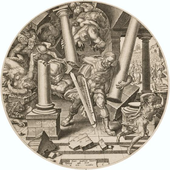
Borders were framed in prophetic ways for 5785, as if created by the force of worship: as if the expectation of the year were an anointing of a monarch, able to set those borders, returning to a new level of reverence for life, and restoring favor to the land; numerologic glosses on this year’s digits, 5 + 7 + 8 + 5 = 25, or two fish and five barley loaves of abundance, affirmed God’s intelligence in providing, and encouraged thanks to God’s demands for a candidate to enact his will, and service in the election to confront those intimidating giants that have threatened the nation as David threw five stones against intimidating giants with the outpouring of spirit and a new battle plan. Despite transposition of loaves and fishes to decipher the prophecy of the year, the gloss demanded believers give freely of what God needs of us–votes for Trump?–to steward of things beyond individual needs. The message emblazoned on the man’s cap burst on the eyes of customers akin to the revelation of the prophetic writing that burst before the eyes of Nebuchadnezzar as he stole the sacred goblets and golden cups from Jerusalem’s Temple, perhaps seen as somewhat akin to the stealing of the vote and White House–as prophetic words of caution and terror, “mene, mene, tekel, upharsin“, letting him know the4 days of his kingdom are indeed numbered. If Svetalana Alpers argued that Rembrandt painted gold objects and clothing to play with the value of the painted work of art, the below painting of Belshazzar’s Feast, far from a foray into the baroque, is an escalation of the rendering of gold of a new level of the divine sublime of perhaps the greatest value–gold letters drawn by the disembodied hand of God, a model far from the glittering if polished mock-gold facades of hotels Donald Trump so delighted to inscribe his own name in capital letters to convince the world of their inestimable value.

Rembrandt van Rijn, Belshazzar’s Feast (1635-1638), National Gallery, London (Daniel 5:1-31)

Only the visionary Daniel can interrupt the mysterious letters–apparently arranged in an acrostic cypher, that evaded the interpretation of any Babylonian wise men, as a prediction of the doom of the king and his dynasty. The failure of the royal astrologers Belshazzar had summoned to read the golden letters were only able to be read by the visionary Daniel, who realized the doom they prophesied was evident to all who read the letters as columns, rather than trying to force meaningful words by reading from right to left. The discovery that God had numbered the days of the kingdom of Belshazzar in the Masoretic text depended on glossing the same verb as both senses of “numbered” and “finished,” the third column as “to weigh” and “find wanting,” and the fourth as both “divide” and “Persia.” In the electoral fantasies of a divided nation, wanting the election of a true leader, the cap had of course provided the illustration of a direct tie of individual to leader, a sartorial proclamation of a direct allegiance to a leader akin to the brown shirts of Nazi storm troopers issued from 1925 or the immediately recognized uniforms of Mussolini’s blackshirts.

If the inscription that Belshazzar witnessed on the Temple walls demanded Daniel’s interpretation to decipher, eluding even the Babylonian wise men, any in the know grasped the meaning of the revelation of Trump’s name in Hebrew–a revelation akin to the inscription traced on the Temple wall. There is nothing wrong transcribing a candidate’s name to Hebrew characters–but the valor into the cap seems to violate a division of church and state, commanding a vote for a candidate as if it was a message from on high, and question of obedience to God. The inscription of Trump’s name in Hebrew characters assume a divine command, as if invoking a scriptural authority in Trump’s support. Rembrandt relied for the top-down columns of his painted Hebrew characters on the learning of a rabbi and printer who lived in Amsterdam’s Jewish quarter, Manasseh ben Israel, despite incorrect transcription of one character–a zayin for a nun–render the luminous prophetic inscription traced by a disembodied hand on the temple wall to the amazement of all present:

Rembrandt van Rijn, Belshazzar’s Feast (1635-38), detail: Inscription on Temple Wall, ()

The difficulty in interpreting the Aramaic chiding that was included in Daniel 5 derived from the encoding of the sacred message in an early form of encryption, a matrix of coded data that demands to be read from top to bottom, rather than right to left, an early form of cypher that was historically accurate, but pushes us to demand the decoding that hat. If the son of Nebuchadnezzar, the conqueror of Jerusalem, had not recognized his own hubris of destroying the Temple and carrying off its sacred vessels to be used as goblets to drink wine at a banquet with his concubines, the cryptic message demanded God be shown reverence as it was dramatically inscribed on the palace wall. If the glitter of gold was a frequent color Rembrandt used in his studio paintings, from helmets to coins to a cuirass, and the artist must have delighted in depicting the abundant wealth of Belshazzar’s Feast by painting the sacred goblets of gold and silver stolen from the Temple.

The set of stolen sacred goblets seem suddenly to fall as God’s hand leaves a shimmering on the palace wall. A shocked Belshazzar sees the inscription with terror as he turns a turbaned head atop which a gold jeweled crown seems to totter; the inscription warns his days of rule are numbered and his dynasty will fall due to failure to honor Israel or the kingship of the God of Israel: the “writing on the wall,” that claims inevitable restoration to a throne of rule by one who honored God in words, Mine, MENE, TEKEL, UPHARSIN, that outshine even his glittering royal gold encrusted cloak.

For the candidate who still reminds audiences of his plans to laud efforts to Stop the Steal, the story of Belshazzar is not only biblical legend. It may even form a natural part of the aura of a God-given inevitability of his return to the United States Presidency. Trump eagerly revealed at a Pennsylvania rally in mid-October how in a “very nice” [telephone] call” he gave Netanyahu his blessing to “finish the job” in Lebanon and Gaza, promising “you do what you have to do” when it came to defending Israel and its border, determined to allow Israel to “ultimately make decisions according to her national interests.” Trump’s affirmations of placing a premium on Israeli interests revealed the far more solid commitment of his relations to Netanyahu than Biden’s; it made him a true confidence man. Trump regaled audiences with how Netanyahu took his call from his private vacation residence in Caesarea after it had been targeted by a drone, reminding supporters of their regular contact, as if to evoke the deep ties a Trump presidency would have to Israel. Trump had, after all, from 2017 transferred the American Embassy to Israel from Tel Aviv to Jerusalem, removed the Palestine Liberation Organization from Washington, D.C., stopped referring to Israeli settlements as illegal and ensured the United States State Department no longer called the West Bank “occupied territories.” This was the very map that Netanyahu presented the United Nations.

To flip the metaphor, the writing was indeed on the wall–and on the map!–since Trump removed occupied territories on the West Bank from State Department map. This “new map” was indeed but a model of the Middle East that the Trump Presidency worked hard to map. In the cap I saw as I canvassed in Nevada, Trump’s name seemed to affirm his destiny to win the election, an event of such historical importance fit for counting from the creation of the world. In ways that recall the insidious intermingling of the sacred and secular in the Trump Presidency, the Presidential election of “5785” has become in large part a referendum on Donald Trump’s continued defense of the United States as a sacred nation with boundaries the former President has defended as if it were sacred and worked to sacralize.

The man’s cap was emblazoned with a logo so aggressive to be tantamount to a revelation: it was nothing less than a divine endorsement from on high, on a bright red field that may as well be glittering in gold. It reminds us of an end times philosophy, and a Republican Party exhorting more arms flow to Israel to defend the sanctity of the borders of a Holy Land. It affirms the impending inflection of global history 5785 is destined to bring. Indeed, the date on the cap may gesture to revelation of Ezekiel 47:13-20, sketching “Boundaries of the Land,” a vision of the future boundaries a restored land of Israel, running east to the Jordan, that run near Damascus, unified “into one nation on the mountains of Israel” with a temple at its center.

This vision of reconstituting the State of Israel was of course of meaning among Christian Zionism not as a political affirmation of an apartheid state, but a precondition for the end of time, and return of Jesus; the religious right’s ideology interpret all Middle Eastern politics through the lens of a prophetic of end-time teleology and premillennial belief, more than geopolitical dynamics let alone a demand for human rights. The previous President has nourished if not cultivated an intentional confusion of a vision of geopolitics with one of spiritual authority and territory with a revelation of a scriptural legibility. Even as we continue to insist that the conflict is between nation-states and ideological in nature, and demands to be solved between nations, by shuttle diplomacy and Secretaries of State, the confusion between a sacred map and a map of territoriality of the Middle East has been nourished in that vision of the Middle East for decades, juggling around the pieces as if to find a winning and unable solution. For we continue to insist that the conflict is geopolitical and at base ideological and between nation-states, in ways that blind us to its distinct and deep-seated nature of these claims of territorial possession, as if is between nations among other nations, as if purposefully creating and bequeathing blind spots in our maps.

5785 has been called a year to invest kingly and priestly authority, await divine intercession and kingly rule, a year of righteousness and peace where the Lord will give what is good to yield increase and a year of awakening. If the current Middle Eastern situation has proven to be a time of crisis not only in Gaza and Lebanon, and Israel, but a moment of revealing the lesser role that the United States can play in global affairs and global wars, an apparent lessening of authority and prestige that seems to show the weakness of the Biden administration, and reorient America’s relation to the world, and the apparent erosion of anything approaching a secure grip on global affairs. In the legend of Balshazzar, the hubris of the worldly ruler is punished by the inscription of the legend that the King immediately beholds, with his assembled guests, who dropped the sacred goblets from which they were obliviously drinking wine in shock. “The God who controls your life breath and every move you make–Him you did not glorify! He therefore made the hand appear and caused the writing that is inscribed: Mene Mene Tekel Upharsin . . .” that predicted the doom of the pagan ruler and of his dynasty, from a God who would soon bring both to their ends (Daniel 5:22-25). The writing was, as it were, on the drywall in the Nevada hardware store that I glimpsed the MAGA hat two weeks before the Presidential election. Maybe 5785, I thought, will be a year all plumbing issues will be suddenly resolved, fixtures will be free and lightbulbs easily able to be returned.

Leave a comment

Filed under boundaries, Gaza, Gaza War, Gaza-Israel Boundary Wall, Israel, Israeli Borders, Israeli-Palestinian relations

Gaza, Again–and Again

The territoriality of the Gaza Strip continues to fascinate for its levels of history and to confound for the grounds of its destruction–as destruction seems to erase any claims for actual sovereignty. For while the claims of territoriality and sovereignty are deeply intertwined, the Gaza Strip being occupied by Israel but being destroyed for its claims to territorial autonomy–the Gaza Strip has become the focus of global frustration and a case study of the disproportionate military response. If the invasion of October 7 seemed a case study of the entry of cross-border munitions into an enclave that seemed isolated by naval and ground blockades, the unprecedented scale of airborne attacks seeking to dismantle the organizational networks of terrorist groups who launched the bloody invasion has provoked new questions of mapping–mapping the scale of destruction, the ethical limits of destruction of infrastructure and historical buildings of sacred import, and indeed the Palestinian landscape by which Gaza was defined as a legacy of ancient Palestine of Canaanites and on the southern plains of the Mediterranean, long renowned, paradoxically, for its ability to resist invasion and assault. For, far beyond the maps of bombings, military presence, and fatalities or damaged property can suggest, Gaza exists in a cartography of the covenant, and a map of Abrahamic covenant, in which the given worldly laws and legal territorial boundary lines are moot, and a contract of covenant trumps the variety of temporal laws that have been drawn around it.

In an era of web maps, this post will risk suggesting, we might be expected to be able to discern and be familiar with the variety of layers of a worldly map, in which the covenential contract Abraham won promised a land, even if one which he would not see revealed or mapped in the limits of his life, for his seed, an inheritance whose architect was God, who would no longer “live like a stranger in a foreign country,” but his seed, even if his wife was beyond child-bearing age, was a metaphor for Israel, were indeed “longing for a better country,” where they “had opportunity to return.” The continued occupation of the Occupied Territories could not, in a sense, be rendered by geopolitical maps as an occupation, so much as they reflected an Abrahamic inheritance that affirmed the pious intentions of Abraham “to go to a place he would later receive as his inheritance,” and Gaza was a site from which the sovereignty of that inheritance was able to be threatened. The eternal nature of this contract of covenant was a deep cartography of sorts that underlay the phenomenal maps of the destruction of buildings, death of civilians, which are almost epiphenomenal before the deep existential conflict Benjamin Netanyahu imagines between himself and Hamas’ leaders, and a still deeper contractual covenant between Israel and the God of Abraham. Yet how to justify or balance the maps of bomb damage, so destructive even if epiphenomenal in the grand scheme of things, with the conceptual reality of the covenant seems to lie at the base of the ongoing bloody conflict as much as how lines of sovereignty and jurisdiction are to be drawn or redrawn on the map of the Middle East port city of Gaza.

If the boundaries of the Gaza Strip were defined as a Palestinian enclave, it is not clear if it will ever be part of a Palestinian state, and the place of Gaza in the Israeli nation has come to a head as a crisis of sovereignty, and we try to grasp the scale of buildings across the Strip have been destroyed in attempts to destroy and eradicate the terrorist network who invaded settler communities so brutally, relying on satellite data as news coverage is silenced on the ground, as much as we can tell from Decentralizerd Damage Mapping Group, hoping to secure a sense of objectivity and transparency in a region that is riddled with national biases and national news. 

Buildings Damaged or Destroyed per Satellite, October 5 to November 22, 2023

By January 5, the destruction of buildings in North Gaza had risen to 70-80%, or up to 40,000 buildings, and 70–80% of the Central Gaza Strip, making one wonder what sort of sovereignty can exist over it, or how the extent of its infrastructure’s destructino has obliterated its territoriality.

What sovereignty exists over the territory that is at risk of being one of the major humanitarian crises of recent years? The crisis was pressingly stated by the murderous if not barbaric invasion of October 7 that ended the peace Israel has established at great cost in the so-called “Gaza envelope.” And they are at a head in large part due to the asymmetrical relations that have been created by the boundary, constructed at great expense within the state of Israel, at its perimeter–the very area where the incursion of terrorist groups, armed with that led to the ground invasion with grenade launchers, assault rifles, and light machine guns as they entered the Palestinian enclave.

If Gaza is a remainder of Palestinian settlement, amputated from Israel, but a sort of ghetto resulting from the expulsion of Palestinians new state of Israel, it is a twin of the foundation of Israel. Its lack of sovereignty is a negative reflection of Israel’s sovereignty, and has shrunk as the Israeli nation has been defined for the Jewish nation, rather than for Palestinian presence, and has refused to incorporate the future of a Palestinian state. Instead, the Gaza Strip has been set apart, and physically bounded, to illustrate Israel’s longstanding control of this border, around not only the Gaza Strip but the geographic creation of the so-called “Gaza envelope”–the securitized perimeter of Gaza, or עוטף עזה, premised on an absence of sovereignty in relation to Israel.

If Arab-Israeli Wars were admittedly central to the emergence of Israel, it is the denial of political status to its residents–ostensibly still members of the Israeli state, if one can believe it–who are denied sovereign status. The denial of Arab sovereignty is crucial to the Gaza War, which risks foreclosing a hoped for “two-state solution” it may consign to the dustbin of alternative history, but cordons off the perimeter of the state. The layers of the data visualization that cannot suggest the boldness or bloodiness of an invasion that led to the “peace” of Israeli civilian settlers being openly violated, violently raped, killed, or mutilated in what seems a truly orgiastic violence that left 1,200 civilians dead, was more than a push-back against containment within a perimeter. 

It was a denial of sovereign rights to possession, and indeed a slow tightening of a grip that refused the importation of gas, water, goods, or indeed medicines into the Gaza “Strip,” a name whose belittling of territory and territoriality is almost itself an insult to the sacred nature of the mosques and shrines that exist on its historical land–only six shrines of a former remaining standing after the pummeling of the Gaza enclave with aerial bombardments of 2016, and over two hundred archeological sites of public memory–ancient churches, mosques, Byzantine architectural monuments–have been destroyed by late December, 2023, per the Gaza Media Office and Middle East Report; by the start of 2024, the Anthedon of Palestine, Byzantine church in Jabalia, shrine of Al-Qadir in the central Gaza Strip, as well as the Greek church of St. Porphyrius have been destroyed. Is this a desire of revenge for the desecration of Jewish synagogues in Gaza City, structures set to fire or exploded by Palestinian residents of Gaza after the October 2005 withdrawal of Jewish settlers left the structures of some thirty synagogues in Gaza City intact that had been built during the occupation period, after removing their ritual books, scrolls, and sacred materials? Arguing that these were not holy structures, but empty buildings without any use, Palestinian Authority decided the assertion of any damage to the buildings would violate Jewish law was derided as a provocation, but their bulldozing was attacked as a “barbaric act by people who have no respect for sacred site,” rather than a reminder of the occupation. The blurred line that led Palestinians to reject their conversion to mosques–a proposal of a Bethlehem rabbi–touched a nerve, as it was feared that doing so would lead to the return of Jews to pray at the al-Aqsa mosque.

The apparent intent of destroying Gaza’s infrastructure has destroyed its public memory as collateral damage. Although raids have revealed a seaside bomb manufacturing site of Islamic Jihad confirm the extent to which Hamas and other groups have used mosques and hospitals as sites for storing weapons and concealing weapons manufacturing sites–the logic of destroying mosques seems a destruction of public memory and preparation that the Israeli Defense Forces have argued since 2014 has only escalated fears inclusion of the Gaza Strip within Israel’s sovereignty, and a need to secure and expand Gaza’s own borders–a longtime delegitimization of the very ability of Hamas or of Palestinians to be protectors of Gaza’s immense cultural and religious patrimony: ”For Hamas, nothing is sacred,” not even the preservation of their historical heritage and legacy.

The invasion of the Gaza Strip has advanced a blanket denial of sovereignty to its residents. If Israel has controlled Gaza as an edge of the state, monitoring since the withdrawal of Israeli troops from the region in 2005, almost twenty years ago, its airspace and marine ports, as well as entry and exit to the region, it has pointedly denied the health or well-being of the enclave’s inhabitants. The provocative concerted violation of the boundary barrier around Gaza Strip was intended as a shock attack that was itself a shock, that was even more violent a shock with the murders and hostages that groups allegedly tied to Hamas took, was not only a loss of life. And the scale of that invasion, marked in a ghostly manner in this map of the Israeli Defense Forces invasion of the Gaza Strip’s autonomy as an enclave of Palestinian identity in this intelligence map form Islamic World News, as the blue arrows of Israel’s armed forces entered four crossing points on the Gaza Strip perimeter.

The shocking realization the “envelope”–a military construct, but also a psychic shield–had been so violently pierced, towers of surveillance hit by unmanned drones and the boundary of safety that created over almost twenty years around the Gaza Strip broken, created a tectonic disruption of the strategy of containment from which the Israeli state will be psychically recovering for years, and has offered the unimaginable fictions that terrorist cells peddled to the hostages the they took of Israel’s actual destruction as a state.

Israeli Prime Minister Netanyahu rather darkly jingoistically proclaimed the Gaza War “a second war of Independence” as a rallying cry to unite the nation, telling the nation after massive aerial attacks began that the air offensive was an offensive “only at the beginning.” The elimination of an enemy that had made mosques, hospitals, and private residences as military installations–and insisting, as the platform for his party has declared its role in protecting Israeli sovereignty “Between the Sea and the Jordan,” as if to rehabilitate hard-line scriptural geography of protecting all Israeli settlements in nominally Palestinian territory. In piercing the barrier around Gaza in over thirty sites, the raids overwhelmed border technologies, the beneficiaries of a growing arsenal of cross-border attacks, by no means limited to Hamas or to the Middle East,–even if they are compellingly mapped as a local attack.

But the attacks can only be seen in global terms–both in the arrival of arms to Hamas ferried across underground tunnels, and long stored as they accumulated as a hidden arsenal of attack, and the fuel for a cataclysmic struggle that the al Aqsa Flood promoted itself to Palestinians, as a campaign of vengeance and global destruction that would overwhelm Israel and Jerusalem at an apocalyptic scale. The concerted cross-border attack used a new range of weapons–unmanned arial vehicles (UAV’s) or kamikaze explosive drones to undermine the very technology of monitoring the border that the Israeli government constructed as an impossible border, a structure repeatedly praised as an “iron wall” against terorism that had fostered some quiescence by its high tech appearance.

The conflation of the 2.3 million Palestinians that the IDF had blockaded into Gaza Strip with independence seemed perverse, but the cordoning off of Gaza was tied to Israel’s birth, and it was undertaking a massive ground war against “the enemy”–Hamas denied Israel’s right to exist on the map from its founding charter, committed to Israel’s removal from maps of the Middle East. The extreme violence of the cross-border attack that left 1,400 dead, was enabled, this post argues, by the new nature of cross-border war–the technologies of border warfare that were used to clear any Israeli claims to the land from its 1988 Charter, including to construct a border. The construction of the preventive barrier seemed to amputate Gaza from the well-being of the nation, filling the Likud party’s new Charter rebuffing the Palestinian demands for a recognition of their presence on the map of the Middle East by openly resolving that “Between the sea and the Jordan there will only be Israeli sovereignty.”

This reiteration of a scriptural map rehabilitates hard-line Zionist beliefs to refuse accommodation, imagining Israeli boundaries apart from a Palestine presence.  In this geographic imaginary, the separate sovereignty of Gaza and the West Bank do not even merit mapping, but could only be permitted behind an actually impractical and costly architecture of boundary walls.

For perhaps the most terrifying aspects of the Gaza War is the juxtaposition of technologies–the barbarity of the murders and the military technologies of death. Those technologies had pierced the perimeter that Israeli Defense Forces had so carefully built, and entered the state of Israel that had been nominally and notionally securitized, a bulwark in the desert. And as much as the death of so many civilians and military shocked, disturbed, enraged and maddened, the nature of the attack that overwhelmed border technologies was a sort of wake-up call that also warned Israelis, in critical ways, of the range of armaments that had indeed entered the Gaza Strip. As the search of the Gaza Strip has confirmed, with its range of anti-tank missiles, the tanks that guard the perimeter of the Gaza Strip are not invincible bulwarks against the Al-Aqsa Flood or the deluge of armed Palestinians; the image of a full-scale destruction of the Israeli city of Jerusalem was less an actual target, perhaps, of rockets, but a motivating cry to urge border-crossers to cross into Israel, armed to the teeth, to unleash a level of violence more unnatural as Hobbesian state of nature.

Their deep success, if it can be called that, in penetrating the Israeli psyche, both by taking hostages and violently killing civilians, in ways somehow were not monitored or guarded against, that a range of weapons had arrived in the small enclave through its tunnel network–bombs, missiles, long-range rockets, and the particularly disturbing innovative cheap tools of attack drones, that allowed the incursion into Israeli territory by the new dotted red frontier of Palestinian advances into the land that seemed “settled” by kibbutz. And it called into question the project of kibbutzim that had devolved or evolved into tools of what might be called frontier settlement.

The desperate coloration of Palestinian presence in the Gaza Strip by bright green to denote presence and resistance of Palestinians in the enclave was mapped onto its topography, in a decisive act of cartographic settlement and naturalization. How did the narrow territory of the Gaza strip, which lacks sovereign status, become conflated with independence of a sovereign state? T

he “envelope” or perimeter around the Gaza Strip was after all a cartographic creation of Israel’s independence, a consequence of the Palestinian Nakba, or removal from Israel. The presence of Gaza at the intersection of tectonic plates moving apart have shaped its borders more than scriptural precedent or sacred archeology. Gaza has become an “edge,” however, of geopolitical contestation, idriven by longstanding and building historical tensions is concretized by the architecture of the border wall that have bound the Gaza Strip. For the border has been engineered both as an architecture constraining movement and its architecture of regional sovereignty.

The perimeter technology has been sealed, as a walled-off region. Cut off from electricity, energy (paralyzing hospitals, desalination plants, and business), Gaza is perhaps one of the only regions of the world that is now offline, and off any grid, internet access cut as well as access to ocean fishing, as mobile and IP cell towers are felled, allowing one of the most densely habited areas of the world to become more isolated from the world, as internet traffic flatlined for 2.2 million, before guiding to a halt by late October 27 to make it one of the least active in the world, more like Antarctica or the African desert, rather than one of the most densely populated areas on earth.

The internet shut-downs appeared part of the war of aggression not only as a news black-out, but to cut off Gaza from the world by cutting off its internet connectivity, suddenly ranked “poor,” per the nonprofit Internet Society, a forced impoverishment as punitive as its aerial bombardment. The scale of damage or destruction of over a third of buildings in Northern Gaza suggest an even deeper flatlining of civic life. This is a register, a record, of what life behind the border wall, that may well make use think more about what it meant to stand before the border wall.

Even as Israeli troops attacked the enclave from which Hamas, whose military wing staged many rocket attacks and bombings in Israeli territory since the 1990s, the lack of any sovereignty suggests a troubling para-territoriality of Gaza. As Gaza, a historic region, was reduced to an enclave without sovereign authority, it stands apart from Israel’s nominally pluralistic society. What was once seen as a frontier–and indeed was cast as a frontier of settlement as Israelis settled the southern edge of Gaza–has become monitored by airspace and at sea mapped from its confines at the edge of the state. This edge became a gaping hole in the architecture of border defense.

The audacious border-crossing from Gaza demands attention not as a frontier, as Hamas seemed showed the world that it could cross the sophisticated boundary forces worked so hard to secure, as they dismantled the sophisticated equipment at the border and bases closest to it, shocking the Israeli border control apparatus forced to repair observation towers and to rebuild fences to secure the compromised network of seniors, radar and cameras that make up the border zone.

Snipers, drones, bulldozers: Gaza border guards recount Hamas attack

The surprise attack on Israel were shocking breaches by which the military wing of Gaza affirmed a porous relation to Israel, and defined by brazen violent crossings of its “border,” suddenly not a frontier, but a region that could be openly crossed. Although Gaza is nominally governed by Cogat, the responsible organ of Israel’s military authority that governs Palestinian occupied territories–it exists as only occupied as a frontier, existed for Israel entirely as an edge that was secured by the state, across which any movement of people, goods, energy, water and equipment are restricted: and with 97% of the enclave’s water undrinkable, rolling energy black-outs, and restriction of wifi communication, the marginality of the enclave is becoming normalized more than its presence. When Israel’s new war cabinet declared common ground around a determination to “wipe Hamas off the earth’s map,” they were adamantly responding to the commitment of Hamas “to wipe out Israel” to be sure–“we won’t discuss recognizing Israel, only wiping it out” said Yahya Sinwar.

The global scale of this rhetoric of cartographic cancellation has grown as the fortification of the border has grown, under-written by interests of national security, as Gaza has been supported by Islamic states–and a new range of cross-border missiles and drones, mostly tied to Iran, if with ties to weapons merchants trafficking in arms and unmanned aerial vehicles made in South Korea, and UAV’s made in Tunisia as well as Russia. For the Gaza War has become a global war, rooted in new means of cross-border wars. We cannot reduce the war to a conflict between Israel and the Izz al-Din al-Qassam Brigades. As much as this conflict has been mapped, rooted in the network of tunnels beneath hospitals and refugee camps bombarded by Israeli Defense Forces, to do so ignores the rise of a new nature of cross-border warfare that inspired the conflict, allowed it, and has increased its intensity. The rise of-a rhetoric of cartographic obliteration is rooted in the global triumph of Islam, to be sure, but a new inflection point of geopolitical tensions. (So much is revealed in the distasteful image of a snake, whose skin is of the color scheme an Israeli flag, that wraps itself jealously around the globe, a concretization of a trope of jewish globalism embedded in anti-semitism in the fabricated Protocols of the Elders of Zion, posing as a revelation of secret Jewish rites: the tired tops of Judaism as a globe-devouring snake bent on global conquest was familiar:

Protocols of Elders of Zion (London, 1978)

The Protocols were a forgery, but had unsurprisingly won a second life in the Middle East, the alleged plans for global conquest adopted to attack the attempts to settle what were mapped as Palestinian lands. The false tract that revealed secret agendas was endorsed by Gamal Nasser and Anwar el Sadat of Egypt, and has been adopted from Iranian Revolutionaries to Hamas, as well as Islamic Jihad and Palestinian National Authority who have included it in their own school syllabi–it was even sold on iTunes in 2012! The charge of global domination was any easy and dramatic visual gloss of the Palestinian-Israeli conflict, and constraints around the Gaza Strip, rather grotesquely repurposed to center a globe encircling snake around its actual geographic location.

Detail of Recent Anti-Israeli Reiteration of Stock Anti-Semitic Trope Distributed Online

The photoshopping is a crude map of the illegality of Israel’s pretensions to include the deserts of the Sinai–or Egypt–in its territorial claims. It is uses a rhetoric of globalism to magnify the affront of a securitized border. But the built boundary perhaps promises to be a blockage of any future movement toward negotiation, as my previous post argued. There is a literal sense in which it is true: for the Hamas invasion of October 7 existed off the map of Israeli sensors, by wiping surveillance systems off the border map that IDF had patrolled, to sew massive disorientation across the nation by disabling security systems.

The Israeli government had for too long removed Hamas from its map of military intel, believing the group to be safely sequestered and confined behind a secure wall, not needing to be mapped. The divergent realities on alternate sides of the border wall. This is no isolated cross-border attack, but a sign of the danger of future attacks: as Hamas officials, even after the bombardment of the Gaza Strip, have predicted future attacks will continue “again and again until Israel is annihilated,” this is a new gambit of cross-border war.

Both, of course, had relinquished hopes of negotiation, and devised strategies to remove the need for ever attending to their neighbors, but that is another story than this post can tackle. To reduce the conflict to a polarity–as if the military organization locked in eternal warfare with Israel, crying, with Samson, “Lord God, remember me, give me strength one more final time to punish these Philistines for tearing out my eyes!” even risking their own death–bears down too closely on the geography of the Gaza Strip, and ignoring the power of what it means to stand before the Gaza Strip’s boundary,–not as a frontier, but as a different reality, that made residents of Gaza so deeply committed to the rhetoric of annihilation, and the liberatory nature of rebordering, an al-Aqsa Flood that claimed Palestinian territory “from the river to the sea” would, as Israelis understood it, activate an image of erasing Israeli sovereignty from the Jordan to the Mediterranean. But if the October 7 invasion of Israel seemed an attempt to advance beyond Beersheva, and unit the Gaza Strip and the West Bank, the polemic charge of the slogan had been festering as Israel governments had claimed their own rights to claim full sovereignty over the same area, as if two overlays on the map were competing with one another, flickering with an intensity to drive the observer insane. The flattening of space3 that

The cartographic flattening of on-the-ground realities in both visions have created an untenable situation, a flattening that was perpetuated in the broad strokes of the accusations of genocide, and the identification, however unwarranted, in the United States, of a president navigating difficulties of the alliance with the Israeli state, to what is best understood as the hashtag of #GenocideJoe, as a way to open eyes about the complicity of the United States within Israel’s invasion of the Gaza Strip, first by American Muslims for Palestine, and then via the Electronic Intifada Podcast, streamed a vision of Zionism = Fascism, and legality as a concept that must blanket immigrants, gay rights, transexual rights, and equal schooling, as if it rested in a uniform colonial mindset that might be mapped around the blood red cartographic sigla of the Israeli State–

Chicago, Illinois

–and blaming “Genocide Joe” and “the Democrats for allowing this genocide to happen”–even if boosting the invasion and bombardment as a genocide risks making a caricature of a deeply evil assault on an entire people, seeking to exterminate them in totality, as much as stage an expanded invasion of the perpetrators of an actual crime. The odd taking of President Biden with an upside down triangle of a political opponent suggest a transposition of categories or categorical confusion.

WSJ Opinion: The 'Genocide Joe' Protesters and the Democratic National  Convention
Chart of Prisoner Markings

For the dual bifurcated realities that emerged on each side of the barrier were difficult to sustain. Gaza is not only cordoned off from prosperity, but a region which faces over 40% unemployment–now approaching 50%–and levels of depression and economic stagnation unimaginable in any western country or any developed nation. For many of those with jobs, the onerous task of crossing the very few open border gates to enter the parallel universe that exists nearby, in Israel, that in fact transcends the ability of some to even communicate to their families: they have visited Jerusalem or other cities, have even seen the historic al-Aqsa mosque after which the invasion of the occupying power was named and consciously intended to evoke; their experience of the border is not often in our maps, but they evoke an imagined voyage to Jerusalem in their war of liberation, freeing al-Aqsa and indeed fomenting an uprising called the “al-Aqsa flood,” xعملية طوفان الأقصى, with good reason–conjuring a biblical flood that would rise from the outpost on the Mediterranean, one able to wipe away the stark differences in the divergent realities in which many live as a motivational charge. The cleansing image of the “flood” narrative to return the region to a primordial chaos, able to remake reality for the righteous, and wipe away the violent nature of a painful chastisement that would not “leave upon the land many dweller from among the non-believers” who will be drowned because of their wrongs was an illustration of the need to fear the greatness of Allah in the Quran, remaking the global geography by opening up expansive pathways.

This was far more more than an energizing rallying cry. The opening up of “wide pathways” in a “wide expanse” was a reaction to the absence of connection between Palestinian lands, the enclaves that were once imagined to be linked by underground tunnels, nourished in the labyrinthine structures of a tunnel network that expanded in Gaza built from when Hamas took control of the Gaza Strip in 2007, outside of the surveillance of Israeli government, some two hundred feet underground, eluding GPS surveillance systems, a site of resistance whose network stretches for miles beneath not only refugee camps, mosques and hospitals but contains rooms, chambers, and passage-ways hostages are held and arms stored. If the apparent carpet bombing of Gaza City was reflected that the groundplan of IDF military offensives in Shijaiya or Beit Lahiya to search for the captured soldier Galid Shalit taken as a hostage in operations that Prime Minister Netanyahu called “necessary to the security of the Israeli nation.” The military’s prioritizing of destroying the tunnel network was reflected in how military spokesperson Eytan Buchman a decade ago explained “all of Gaza is an underground city, and the amount of infrastructure Hamas built up over the years is immense– . . . tunnels, extended bunkers, weapons storage facilities, even within urban areas.”

The massive underground tunnel network–here shown only by those halls that wer mapped by the Israeli Defense Forces–was used as sit a network of tunnels of resistance as the dream of connecting Palestinian enclaves has receded with time as were first proposed to manage the possibility of removed self-governance that Israel could “live with”–including access to two ports–

The Gaza-West Bank Tunnel in the Trump “Plan, “Future State of Palestine” (January, 2020)

–the idea of a “tunnel” not under Gaza, ut linking Gaza to the West Bank, was on the table as a proposal for the “future state of Palestine” even if this waggishly accused as being a “hollow state.”

The network of tunnels had been the staging area for attacks on border cities in the past, including Kerem Shalom, the border crossing where Palestinian militants attacked, in the course of the raid seizing soldier Shalit a hostage to abduct to the underground labyrinth in the Gaza Strip. The warren is known as the “Metro” in acknowledgement of the underdeveloped and unmodernized state of Gaza –Shalit was held for four years, to the surprise of Israelis if never of his own family. This is the underground network where the current hostages are probably been secured, and has become a showpiece of engineering and a feat of resistance in itself, extending despite the built boundaries in cleared boded lines that promised an infrastructure for future cross-border attacks.

The Metro became a showpiece, but a site for staging nationalism in summer camps, in the poor state of the Gaza Strip, promoting her heroic ideals of Hamas militants for independence, and fostering the dreams of tranport beyond bored walls of an ever-expanding underground network.

Israel Palestinians Hamas Tunnels

Denoting the narrow underground tunnels as a ‘Metro’ is not only in jest: a decade ago, the artist Muhammad Abu Sal, then 35, decided that the tunnel network demanded to be highlighted as an economic infrastructure of its own for smuggling weapons, goods, and people; as an underground critical part of its economy, he promoted network not as a secret warren but an form of modernity that might in the future provide a network connected Gaza to the West Bank by analogy to Paris! (The ferrying of kalashnikovs were not the original intent of tunnels that linked the Strip to Egypt, border, began as a way to import a variety of necessities that were absent from stores in Gaza’s after the imposition of a 2007 blockade on the enclave, from food to cars to even petroleum fuels.)

The bright and bouncy iconographic modernity of a subway modeled after that in Abu Dhabi, Paris, London, or New York that was staged as a theater piece for the Festival of Cultural Resistance three years ago in 2020 painted in bright bubble-gum colors (If Abu Sal was promoted as a “penetrating artist,” by The Freedom Theater, the network that is now getting newsplay as a net of resistance was an economic necessity, but that were mapped a decade ago as a hidden “world of weapons tunnels penetrating into Israel, creating the possibility of a mega-attack” that demanded to be destroyed for the safety of the Israeli state.

Paolo Pellegrin (2011)

This was by no means created as a network for military use alone, but of survival: many worked in the tunnel, hauling goods to the residents of the enclave who suffered from the blockade Israel had imposed from 2007, hauling goods from Egypt in its confines, pausing only occasionally for a cigarette break deep underground.

Paolo Pellerin (2011)

The network of tunnels is but a part of the cross-border movement that has transformed the Gaza Strip from a border zone to a network that stretches underground. Even as Gaza is cordoned off from the internet, is tied to a larger world by nations who have offered new tools of cross-border violence. The effectiveness of the tools by which the October 7, 2023 invasion is proof of technologies to break border defenses, in a variety of emergent tools of cross-border warfare of which we would be better to take note.

Such new strategic technologies were not only tactical. They ensured the parallel world of the prosperity beyond the border wall, in the land of their occupiers, suddenly was able to access by dismantling the very surveillance apparatus of the border Israel’s government had so confidently invested, secure in the conviction it would not eve have to negotiate with Palestinians,–just confine them by an ever more clever security wall. Massive state investment in technologies of confinement have been felt by residents, as they have cut into farm lands of Gaza’s residents by the expansion of a “No-Go Zone” around its perimeter, to contain risk,–

–pierced as “kamikaze” aerial drone warfare offered a low-cost technology to pierce its confines piercing the border at multiple sites simultaneously on October 7 at daybreak.

A detailed look at how Hamas secretly crossed into Israel - ABC News

Google Earth

The border technologies of risk-management had nourished a false sense of security. But investing in outdated tools of securitization may have led to a nightmarish return of violence in the single greatest day of Israelis killed, despite all that investment in the secure tools of guarding the Gaza boundary. The invasion of those paragliders landing in kibbutzim after they flew across the border suggested the ease of transit once the observation posts were removed, and border surveillance lifted. It reflected as if in a rear view mirror the incursions of 1956 on refugee camps in Gaza, where Israeli troops led by Ariel Sharon, later commander of the Southern Forces, as commander of a paratroopers’ brigade, staged revenge attacks refugee camps–

–an area whose settlement Sharon encouraged, before unilaterally withdrawing troops in 2005 to comply nominally with a “Road Map for Peace”–without relaxing vigilant naval control of ports or of its airspace. The vision of Gaza as a border state, and a frontier, close to the heart of a previous geography of the Middle East from far earlier Arab-Israeli wars, was encouraged by Prime Minister Netanyahu, and have haunted the sense of Gaza as a frontier on which to focus public attention, as a region over which Israel has critical natural self-interest and a right to protect itself. The “Gaza envelope” was however liberalized as regularly spaced observation towers along the border created a monitored boundary, and which Palestinian observation posts monitored by Hamas took note of all movements of the Israeli Defense Forces by land, air and sea, offering a ground surveillance that the October 7 invasion clearly took advantage of. Palestinian military experts argued that such field posts “may be considered defensive and not offensive since . . . Hamas cannot cover the entire border,” leading Israeli forces to target observation stations along the north-south border, the questions of gaps of surveillance on the border either from the sandy hills of Hamas observation posts or observation towers provided a tactical basis for military confrontation.

So much was confirmed by the cross-border attacks of October 7 in more gruesome detail than could ever be imagined, even by the most hard-line defense spokespeople. While many maps registered the shocking incursion of terrorists–communicating the violence of the even that left 1,200 dead–both soldiers and residents of the new frontier of kibbutzim, clustered around Gaza’s border barrier, we may forget how these pioneers who are also acting as colonial farmers in a more explicit policy of taking back the land up to the wall of the Gaza Strip. If hostages were vulnerable children, concert-goers, and elderly who happened to be in the kibbutzim, these outposts are not friendly neighbors to Gaza. These are victims whose names are recited, and rightly added to the prayers, but were spread about Gaza’s barrier, where they seemed most safe. The attacks that were staged in the invasion followed maps to the settlements–

CBSTV

–the incursion of the barrier and breaching of the barrier wall played on American television news, perhaps, in an echo of the movement across other walls–but cannot be mapped disinterestedly, or at a remove from the transnational ties that have redefined the geopolitical plate-tectonics of the region.

Weren’t the settlers who were encouraged to settle just beyond the boundary perimeter, as part of a new “frontier state” of Israel, promised a false sense of security by the securitized barrier wall? We may do well to focus our attention on the experience of those 18,000 Gaza residents who work in Israel, or possess work permits–many now trying in vain to contact their families within the region–and the experience of Gaza’s residents as they were on the border, facing the opportunity to travel to work. And to consider their travel past these villages, that were mapped as targets by the invaders who arrived in paraglider or motorcycles at their destinations, believing that they were achieving a remapping of the Middle East long mapped to their disadvantage.

If all crises are overshadowed by the climate crisis today, the top driver of human suffering, the absence of water in Gaza, were some 97% of water is not drinkable, given a highly contaminated Coastal Aquifer so combined with salt and untreated sewage to be unfit for human consumption, even before the bombing destroyed much of the plumbing infrastructure in urban areas that have provided the main conduits for drinking water to arrive in the enclave that lacks a water grid, the closing of electricity to the region has shuttered desalination plants and local wells. The water available to the residents of these nearby kibbutz, where the farming of the dry desert soils offered a basis for viable agriculture, were a stark contrast of inhumanity, making no geographic or environmental sense, as the engineering of desert farming by tools of drip irrigation–pioneered in the southern Negev, now using recycled wastewater from Tel Aviv!–as well as permaculture, in organic farms removed from the local water table. The isolation of Gaza from drinking water or functional farms has created a water crisis with deep health risk.

The borderline war between Israel and “Gaza” was fought less on borders than hinges on exactly these forms of trans-nationality. The haunting nature of the border as a divide assumed disproportionate presence for Palestinians that cannot be reduced to metaphorical terms, but were able to frame a new world view. The trans-nationality extends to migrant workers who found a new life to work beyond the border walls as service workers in Israel, and glimpsed a sense of another life,–or heard it recounted on iPhone or mobiles from household members who did. Trans-border movement in a global labor market found something of an echo in the tunnels of the underground “metro”–a hidden map, as it were, removed from surveillance and Israeli observers–that connected the terrorists of Gaza to a market for international arms, ferried, one suspects, from North Korea, whose arms were used in Syria and Lebanon, as well as Tunisia, Iran, and Egypt.

These were the arms that overwhelmed the barriers. Though we consider unprepared IDF forces, distracted, perhaps, by the micro-conflicts of West Bank settlers, and maybe some of low morale, but who were looking at the screens that they were provided in boundary monitors,–not at other military intelligence. For the disabling by sniper fire and explosive drones that arrived at the boundary barrier at the early hour of 6:30 am in the morning were an early alarm. IDF guarding the barrier were disoriented by the surprise attack, as gunmen quickly took out observation posts and cameras on the boundary itself and leaving security forces disoriented and disheartened at a systems failure or failure of military intelligence. While the shock of the attack reverberated globally, the unmanned aerial attacks belonged to a new range of arms increasingly stockpiled across the Middle East beneath Gaza City and in the tunnels that constitute the “metro” not only among its military groups, but to the wider arms trade, and the suppliers of new tools of cross-border warfare.

The tunnels passing underneath the very barrier that Israeli contractors built around Gaza after withdrawing troops may have brought a new variety of weapons to the Israel-Gaza frontier, against which the current system of security had no guide. The underground tunnel network that was crudely extended from Gaza’s friable soil far into Israeli territory–or from the occupied territory into the national territory-. The walls became grounds for investing in the critical year 2016 in a border fence, a perimeter state-of-the-art and “smart”–equipped with security cameras, CCTV, and monitors. Yet the persistent trans-nationality of the region was not mapped, as new network of tunnels linked Hamas to arms ferried from Iran, North Korea, and Egypt– conduits of the very border-bursting shoulder-fired F-7 rocket-propelled grenades that are used against armored vehicles, or the thirty-five “al-Zawari” kamikaze drones–named after the Tunisian engineer Mohammad Zouari, killed by Mossad agents in 2021 for designing UAVs–took out many observation towers. The arms that flowed into Libya, as much as from Egypt or Tunisia, may include shipments of Turkish weapons that have flooded Qatar, Tunisia, and Ukraine since 2020.

The cross-border technologies that developed in the very years we assumed the world gone silent before COVID-19, and Turkish Bayraktar drones flooded the Middle East to further Turkish interests, a shuteye also flooded the Nagorno-Karabakh conflict and helped Azerbaijan’s battlefield success, even in the face of a large army of Armenian tanks. And the drones designed by the Tunisian engineer who had learned techniques of drone-making in Iraq suggest a new level of combat, and “borderless war,” once tied to the counter-terrorism techniques of targeted killings, that were–perhaps terrifyingly–critical to the cross-border attack on the border barrier.

These cross-border weapons allowed military stability to be destabilized with disorienting rapidity, upsetting the balance of guarded frontiers, creating gaping holes of security in American-made defenses, or developing extended-range missiles able to target energy infrastructure and oil refineries in an aerial war. In an eery echo of the barrage of V1 and V2 rockets the Nazi air force fired on gyroscopic guidance systems to target populated areas of England in World War II, the GPS-equipped drones may have helped to hatch a project of targeting the observation towers that were the teeth of Gaza’s boundary barrier. The very sort of explosive “kamikaze” Shahed-136 drones of Iranian make whose small fuel pods, as the V2 rockets, directed their explosive warheads at targets in Kiev to swarm defenses with efficacy in 2022 seem, indeed, to have been tested out in an earlier border war. And if the Iranian drones whose 80 lb warheads exploded on contact were described as the “poor man’s cruise missile” by their manufacturers had been used in attacks on American forces in Iraq and Syria, as well as the UAE; swarms of drones fired up by the fifty horsepower engines of the Iranian drones are increasingly been used to eliminate expensive surveillance and anti-aircraft systems, puncturing border surveillance, as it were, opening borders that were heavily fortified. (A recent drone attack on American forces stationed in the Ain al Assad base in Iraq were hit by a suicide drone in the midst of the bombardment of Gaza, claimed fired by the Islamic Resistance in Iraq, and five separate attacks on American bases in northern Iraq were reported, as fears of the war spilling over borders grew.). The use of “loitering munitions” and drones by Houthi fighting in Saudi Arabia have absorbed the large supply of rockets inherited from a Yemeni stockpile of unmanned aerial vehicles, perhaps tied to Iranian weapons technologies.

The result is already shifting the front of war to prolonged missile, drone, and rocket attacks. Technological developments in aerial warfare date from around 2018, often to win withdrawal from occupied or disputed territories in the Middle East, as in Yemen, if they have never been launched against so securitized a border as in October 7 shock attack of the IDF’s observation towers. From 2019 the use of high-precision aerial drones developed new fronts of Houthi cross-border aerial warfare as tools of direct military engagement of expanded military targets, readily including civilian targets that were off the military map, including the targeting of oil facilities, airports, increasingly targeted since 2018, and ending only as a UN truce was brokered in April 2022. Yet Houthis and Salih helped open a new frontier in aerial cross-border warfare, which the shock invasion of Israel’s highly regarded border frontier must be contextualized in–and perhaps also seen as a new proof of concept in cross-border warfare, making a truce all the more important.

This suggests that the Gaza War is the latest front in an expanse of unmanned aerial vehicles–a new era of remotely operated drones programmed in “autonomous mode” that require little human control. The use of swarms of drones have been used extensively in conflicts in the Middle East, including the wars in Yemen and Syria, before they swarmed the surveillance stations of the Gaza boundary wall. The regional spread of such drones is less openly mapped,

But the centrality of such unmanned drones able to focus and take out border surveillance stations may have been neglected in most news reports. The focus on the violation of Gaza’s borders and the overwhelming of the billion-dollar barrier war cannot reveal the danger that the firing of such a swarm of robot drones poses to Israeli sovereignty outside an international arms traffic. The rockets that began the raid that the Hamas al-Qassam Brigades began started not with the DIY “Qassam” rocket of nitrogen-rich fertilizer and sugar,–if the image was worthy of scrappy resistance against an occupier–

PALESTINIAN-GAZA-ISRAEL-CONFLICT-HAMAS

–but the use of drones did show scorn for the proud surveillance towers, disabled by the density consisting of 5,000 unmanned rockets that arrived in an interval of twenty minutes. Their spatial distribution overwhelmed the technical tracking abilities of the Iron Dome, confusing the smart wall that would supposedly withstand any advance. If Samson in Gaza seemed to no longer be the legendary warrior who “ran on embattled armies clad in Iron,/and weaponless himself,/Made arms ridiculous” as he scorned “proud arms and warlike tools,” the army of aerial drones that initiated the unexpected cross-border attack overwhelmed the geospatial intelligence and sensors with which the border barrier was equipped, allowing the advance of men who were armed to the teeth.

In the biblical story of Judges, the rage of a blinded Samson, reduced of his powers of martial strength, is seen as “in slavish habit, ill-fitted weeds/o’re worn and soil’d,” seemed far from that image of the Samson who “weaponless himself,/Made Arms ridiculous” before he, in his rage, lifted the doors of Gaza, carried away the gates of the city, “unarm’d” but summoning his strength as his hair grew that again after he lay in reflection in prison, blinded and distraught as he reflected gloomily on his fate, is remembered as lifting the city gates of Gaza in his rage, bars an all.

Samson carrieth away the Gates of the City, designed by Francois Verdier (1698)

Eyeless Samson is remembered as un superhuman rage, lifting the doors of Gaza by his hands alone, before he carried them off in the dead of night by bare hands to Hebron by superhuman strength.

But this is not a biblical story, even if it happened in a place of the same name. The firing of an army of aerial drones seems to emulate a home-made “shock and awe” that Hamas was sold as a working plan became a proof of concept that impressed the world. The critical use of kamikaze drones to disable the security towers, communication relays, and border surveillance system before the ground assault incapacitatingly “blinded” Israel to the attack, enabling the brutal strike on kibbutzim by a functional mapping of surveillance tools, as much as of the territory that was attacked: the territory existed as a surveillance apparatus, in other words, as a territory, but left the territory vulnerable. The barrage of weapons used did not rely, as in previous years, on the unguided Chinese-designed, Syrian- made rocket, a major element of the Palestinian rocket arsenal that Fatah, Hamas, and Islamic Jihad have often used in attacks on cities near Jerusalem and Haifa–and are commemorated on this mural in Gaza, before which schoolchildren are shown passing–

Children Passing Mural Celebrating Capture of Israeli Soldier Galid Shalit/December 11, 2021/Said Khatib/AFP

–or that Hamas has even invited kids to take selfies before a public display of the missiles themselves in the aftermath of increased Israeli-Palestinian violence in July, 2023.

Mahmoud Issa/SOPA Images

Much attention has been devoted, and alarms raised, about the cross-border and transnational ties of Hamas to military intelligence services of Hezbollah in Lebanon, long before the rise of cross-border skirmishes on the Lebanon border began during the Gaza War.

Yet the routes of intelligence and the uses of older missiles were less central to this conflict. And this time, in other words, we were all reminded the territory was shown to be only a map–increasingly rendered vulnerable as its surveillance structures were disabled by explosive drones.

The place of Gaza on the map is critical, but we need more than arrows to define its space, and to use weapons to erase the boundary barriers that were built by Israel to contain its presence on the map. For the strip has existed in reflection of the guarding of its borders, and the “metro” of tunnels that have let it be linked to the west have become turbo-charged, of course, from the barrage of rockets to the troops who followed, ignited by the giddy vertigo of crossing the border fence that may be missing form our maps as we map the conflict.

Why do Hamas want to wipe out Israel from the world map? - Quora

We might best consider the trans nationality of Gaza as a reprisal of the border strikes that were enabled by the funneling of arms int eh Cold War from the former USSR to Syria and Egypt in order to restrain the ambitions of Israel that American arms bolstered, although the size, apparatus, and techniques of armaments have existed–and the mapping tools that are now part of the arms.

Philippe Rekacewicz, The October War [Yom Kippur War) (1973), Monde Diplomatique, April 1998

The war on two fronts was, as it occurred, a war for Israel’s existence. But as the above visualization nicely reminds us, the strategic alignment of troops in the Yom Kippur war are best mapped not only by military advances, but against the backdrop of importing weapons that fomented the war that felt inevitable. This time, the borders and divides are more defined, and the flows of weapons demand to be mapped. But the combination of the eery flow of Gaza workers into Israel, and the possibility of a flow of cross-border weapons that arrived into Gaza, even as Israel tightened its noose, have inspired a violence that leaves many hoping that the other is wiped off the face of the map. But whatever the map we chose to study, we may misunderstand the locked-in nature of the current war as local, or rooted only in local history: if it is rooted in an occupation, it is also a new stage of the diffusion of swarms of remotely guided missiles, produced on the cheap and not dependent on arms providers in removed areas, as the United States and Russia, but able to be produced in mass quantities on the cheap to reveal vulnerabilities all countries may soon feel.

Leave a comment

Filed under arms trade, drone warfare, Gaza War, Israeli-Palestinian relations, terrorism

Eternal Borders and the Territory of the Gaza Strip

When I attended Hight Holiday services this past year in Oxford’s Orthodox synagogue, it was for the first time in some years. But the spatial imaginary that unfolded in the services days before the invasion of Israel’s “border barrier” on October 7, 2024 suggested how difficult the geography of the Middle East would be. Although it was familiar, I stopped at an old prayer in the Makhzor, or holiday liturgy, praying for the safety of the Israeli Defense Forces as they guard Israel’s boundaries over the coming New Year, 5785.  The creation of these boundaries was noted not in a moment, but have, changed over time. But the notion of fixed boundaries of Israel that Benjamin Netanyahu has long proposed in stated policies that have openly vowed rejecting any attempt to create Palestinian state between the River Jordan to the Mediterranean in a “Great Israel” had demanded Israeli control from the river to the sea–even if the area includes, according to Israeli demographer Arnon Soffer, of 7.53 million Palestinians and Arab Israelis and 7.45 million Jews of fifteen million residents.

The prayer was familiar, but stood out for me as I returned to religious service in a foreign country: the collective imprecation to preserve the IDF currently defending the borders of the Holy Land suddenly seemed an aggressive act. While the Jews living between the Jordan and Mediterranean are in a far more continuous space, in comparison to which the geographic space of Palestinians is of course a far more fragmented mosaic who are without comparable rights as citizens, the borders have been reified by boundary walls in an era when borders are not only far more heavily fortified than ever in the past. For the border barriers around Israel hold mental space before the cry to free the region “from the river [Jordan] to the [Mediterranean] Sea“–a slogan with deep roots in decolonization struggess of the 1960s, if to some ears maddeningly intentionally geographically vague slogan, as if it presumed annihilating the boundaries of a Jewish state–rather than one that denies Palestinians citizenship or rights of movement, a nation bordered by fixed boundary walls.

The militarized borders of the nation-state made the prayer disturbing days before the invasion, or the response to the shock of an armed incursion of sovereign bounds of vicious civilian and military deaths. For if the fears of any assault of Israel’s territorial claims have been met by the increasingly intense fortification of its borders, a ramping up of its claims to “security” and “securitization” that has eroded the ethical values of the state, the defenses of these boundaries were both more militarized and less sustainable in the future, and to begin the New Year by hoping for the security with which they were guarded–as if they were granted by divine right but embodied by militarized defense–was unintentionally quite off-key, and made me grind my teeth during the High Holiday I had arrived to celebrate with some trepidation in a foreign country,–not seeking friendship or continuity but orienting myself to a city I had only recently moved in mid-September. I was not concerned about Israeli borders, but fund the invocation of their guarding to carry a deep weight for the members of the congregation, reminding me that the prayer–an addition after the 1967 War– had long assumed deep significance.

If the New Year’s holiday had some spiritual resonance as a way of marking time, the sense of bonds among Jews grew with the coming invasion, making me negotiate my relation to the service I had just her. Indeed, the explosiveness of the invasion that left me and my fellow-expats reeling and hard to observe at a distance made me interrogate where that prayer had origins, and reflect how the literalization of a project of boundary-guarding had become so dangerous project of courting risks of raised the stakes, intentionally turning a blind eye. If the war was an invasion of Israel territory, the border zone between Gaza and Israel has, perhaps rightly, long been the subject of attention of Israel’s Prime Minister, who has repeatedly emphasized “stoppage points” and “closure” of the Gaza Strip and control of the border zone between Egypt and the Gaza Strip. T he military securitization of these borders were hard to reconcile with the benedictions of the kindly rabbi. He led his congregation a final time in high valedictory form at the cusp of retirement, and stylishly negotiated the benediction to George V in our Mitkhor, to my ears, in an Anglican version asking for the safety of the royal family. In a sermon voicing dismay at the strain of lamentation strains of Judaism that he felt had infected or reconfigured Jewish identity at some loss of its original liberal optimism and pride, he wished us to engage the year ahead.

For a strain of lamentation, derived from the poetics of the laments of the Psalmists, but expanded to the elegiac account of suffering and commemoration that expand the liturgical elegies to accounts of forced conversion, expulsions, crusades, pogroms, and even assimilation short-changed pride of a “chosen” people, the rabbi felt, undermining a sense of pride. The ancient strain of lament in Jewish poetics and poetry certainly decisively expanded in twentieth century before inexpressibility of the Holocaust, and a need to express inexpressible pain in the face of fears of annihilation. But the logic of lament of would come to the surface with quite a vengeance after the unprecedented invasion of Israeli territory on October 7, only weeks after the rabbi’s sermon, as the unspeakable trauma of the crossing of the fortified border of Israeli territory opened existential fears that set in play a logic of retribution. If lament pressed the borders of linguistic expression and actual comprehension, the escalated response metthe anguish of lamentation demands, but no response can ever fully satisfy. The call to pride, and even content with being Jews, was somewhat tempered by the calls to save the warriors defending those highly militarized geographic boundaries, as much as boundaries of expression.

The boundaries of Israel as a “state” had become not only embattled, but less defended lines than firm fences, rigid, and asserting a statehood removed from negotiation, and perhaps from Zionism, as they were understood as bulwark against Palestinian expansion that so tragically ended with the battery of hundreds of ground-to-air rockets forms the long-barricaded Gaza Strip, serving as cover for a bloody invasion of Israel planned for a decade, approved by Hamas leaders in 2021–even known by some of Israel’s intelligence forces as code-named “Jericho Wall,” an attack of unmanned drones to disable the surveillance towers along Gaza border wall, to attack military bases, but dismissed–if it was also feared to constitute “the gravest threat that IDF forces are facing in defending [ Israel].”

The week of intense bombardment accompanied the resolution with which Israeli Prime Minister Benjamin Netanyahu called a press statement to be televised on a holy Sabbath, an emergency exception to the religious calendar that emphasized its urgency, in which the Prime Minister apt to view Jewish identity in an optic of perennial political persecution menacingly told the nation “our enemies have just begun to pay the price” on national television, announcing air, drone, and artillery strikes on the Gaza Strip were “just the beginning” of retribution for the bloody attacks on civilians and civilian abductions from Israeli territory. The claim of a position of power of remotely targeting Gaza was reprised, eerily, when the renewed airstrikes broke the ceasefire of 2025, and Netanyahu declared that the renewed offensive attacks on Gaza would continue, threatening Hamas that the arial bombardment would continue without restraint until the remaining hostages–half of whom were believed dead–would again “feel the strength of our hand” in North Gaza by artillery fire and bombs, again attacking a 90% destroyed region with the approval of Washington, DC.

Strikes across Gaza hit Khan Younis, Deir al-Balah or Gaza City, including refugee camps and a few Hamas officials. The reprise of the ominous neo-scriptural warning–this is only the beginning“–emphasized the divine-like nature of the strike. They heralded attacks killing over four hundred Palestinians, and meant that negotiations would only continue under fire. Warning that remaining in settled boundary regions in “combat zones” unsafe during a “strong offensive against terror organizations,” social media warning used a QR code to caution against putting “your lives and the lives of your family members in danger,” urging residents find “shelters in western Gaza City and in Khan Younis” before the onslaught began, in a new psychology of war during a nominal ceasefire.

IDF Warning Map of Combat Zones, March 2025

This was never a war about defending borders, if the IDF prayer beseeches the divine for help inb defending boundaries: the first a reprisal against the trans-border strike was funded by transnational groups in Iran and elsewhere, but attacking the transformation of the Gaza Strip to a launching pad for strikes into Israel’s territory, as much as securing the borders of the state.

Military Incursions in Gaza by Drone, Air, and Artillery/Armed Conflict Location & Event Data/October 7-27

The horrible and terrible scale of attacks on the heavily populated region affirmed a mental imaginary we have a hard time grasping, but seemed designed to illustrate Israeli control over the region–and over a region from the River Jordan to the Mediterranean Sea–that tried to impose itself on Palestinian cries for a vision of “from the river to the sea,” an ominously vague geography. The bombardment immediately raised questions of Gaza’s sovereignty and affirmed the territorial right of the state to defend its boundaries, even if the boundary barrier between Gaza and Israel was of Israeli military’s own creation, and lay within, technically, the territoriality of the Israeli state.  

The demand to reveal air dominance proceeded in unrelenting ways, as the bloody invasion of Israeli territory had pierced the ability to articulate a response, triggering traumatic memories that have produced an endless outpouring of maps in hopes to remedy how difficult it is to discuss, as if to try to ascertain some objectivity in the actual occurrences, triggering thousands of outpouring of settler violence against Palestinians easy to be predicted, but must be lamented, and an immediate escalation of retributive air strikes across Gaza Strip, as if to destroy its future, airstrikes returning to new heights but concentrated for the first time in one small region: Gaza.

Fears of a cross-border attack had circulated before the summer, and there was concern, with military drills of increasing intensity within the Gaza Strip, of crossing this border. But the barrier seemed to have fostered inexcusable ignorance that may be investigated as if blinders to national intelligence. The invasion’s shock created a vortex of mapping and remapping the Middle East to express its reality on the map, but that reality also seems inadequately expressed by any map: for it was an open denial of a political right to exist, revealing in questioning sovereign claims.

The map of the planned attack routes dismissed as impossible across a monitored border barrier reflects a locked-in mindset that saw the barrier as fixed . The IDF saw the maps of future invasion as an impossibility, unable to see the intense aspirations for the dismantling of the border as an event for which Palestinian groups as Hamas had long planned or might accomplish. Yet the fears embodied as a charge, under the cry “from the river to the sea” of such exasperating geographical vagueness, that seems an incursion of the national space of sovereignty that were hard to imagine, even if it was clearly mapped out as a multi-pronged strike invading Israeli territory, perhaps along new versions of the offensive tunnels that Israel had worked so hard in 2008, 2012, and 2014 to destroy, long realized was a threat to Israeli sovereignty, but had yet not developed tools to destroy. The maps were not by tunnels, so much as overground paths: but in the current Gaza War, the engineers of the IDF would continue to map and reveal and destroy through March, 2024, as combat engineers closed a four kilometer tunnel fifty meters below ground, destroying transnational abilities to attack Israel and prevent the possibility of incursions across its borders, in ways that tested the reconfigured borders and expanded concept of the defense of borders in a globalized world..

Plans for Proposed “Mass Invasion” of Hamas across Gaza Boundary/IDF, July 2022

Yet the nightmare of course returned. While what that consists of became unclear, as the terrible attack on Gaza unrolled in reaction to the bloody October 7 incursion of armed militants into Israel, a stunning cross-border surprise attack across twenty two points of the perimeter that killed and wounded settlers and members of the Israeli army, following a barrage of rockets fired from the barricaded Gaza Strip, entering towns to attack civilians. Can these attacks be seen as part of a movement of liberation, or self-determination, or were they an exasperated crisis of containment by a machinery of war whose gears were already ratcheted up around the dotted border walls.

The invasion of towns sent shock waves through the very notion of Zionism. The rhetoric of liberation of the motivational cry “from the river to the sea” is itself a bid to remap territoriality and territory, of course, and feared as a coded call-to-arms of the Hamas network or the Popular Front for the Liberation of Palestine, seen as a bloody cry to undermine the call for commitment of the Likud Party to defend sovereignty over all land up to the Sea, or Mediterranean. 

Indeed, if the rhetoric of liberation has helped to lead to an unthinkable set of military conflicts on Israeli territory of multiple points of conflict in Israel between Palestinians and IDF, redrawing the very contested barrier built around the Gaza Strip as a barricade of one of the most densely populated regions in the globe, the invasion was a planned refusal of such constraints–

Sites where Terrorist Militants Engaged Israeli Army on October 7, 2023/Visegrád

–to push the border of the Gaza Strip far beyond the massive walls Israel had constructed at significant expense. For if Israeli military had sought to cordon off what has been seen as an existential threat to Israel’s future. If the memorialization of the Holocaust has become central to the demonization of Palestinian terrorists, the border walls that seemed to staunch off a future of death found a terrifyingly brutal invasion by crossing the border barrier, triggering collective fears across the nation of an attack on Israel’s very future.

Indeed, the origins of the arming of Palestinian groups in the Gaza Strip have advanced, from a range of multinational sources, including Iran, to help redraw the boundaries that Israel has long defended, as a way to breach the impregnable defenses that had increasingly been built around the nation to protect it, to try to prevent against increased threats of incursion of a state that refused to negotiate for the future.

Fortified Boundary Fencing and Barriers around Israel/2020

The walling off of the Israeli border by physical barriers in recent years has speed to seek to create a bulwark against such an invasion–as if in response to the cartographic logic of the motivational cry Palestinians have popularized as a form of national liberation. The razor-tipped fencing, concrete barriers, and impassible fences have promised a sense of security in the Promised Land, which may have undermined global consensus the land is promised–and has led to much global anger at the unilateral fortification of the state as a confirmation of the most nationalist hard-line form of Zionism, refusing dialogue and directing military resources and funds to the suppression of any future for a Palestinian state, beyond parts of the West Bank, between the River Jordan and the Mediterranean. Was not the invasion a bitter reminder of the site of the refugee camps established in the Gaza Strip, years ago, at the very origins of the Israeli state, as if the haunting of the region had its own memories, which refused to be silent?

I could not wish for more misfortune to a kindly Rabbi than inaugurating a New Year marked by the invasion of October 7. But the horror that unfolded in coming weeks made those days seem almost halcyon. I confess ambivalence to the faith of Judaism, but the turn of the liturgy to the safety of the soldiers guarding the Israel’s boundaries from its “enemies” made me a bit queasy, and hesitate to follow the prayer, but made me reconsider how the huge investment in those walls–and in their guarding was not also a large part of the problem, that had set in play a dynamic of contesting Israeli sovereignty–and the Zionist promise for an Israeli state–that has reconfigured the Zionist proposal in ways that have since brought unforeseen inflections to the saying Schwer tau sein a Yid, an existential statement to be sure steeped in the memories of the Holocaust, and remembrance, as if passed down through generations, poised to fall into the abyss of memory, before gaining a new spin with the assigning of redemptive strength not to “Israel” but to the barriers to contain threats.

Could it be that the cry, From the Border to the Sea, had not become a conceptual map about the way that the ruling parties had now conceived of Israel and Israeli boundaries? Indeed, Netanyahu had made clearly cartographic campaign promises, in 2019, to reduce the Palestinian Territories if re-elected, promoting 2019 as a unique “opportunity” to “kill all chances for peace” of the sort that rarely arrived, and had not existed since the Six Day War of 1967, an opportunity for redrawing the map from a position of absolute authority by whittling away at a third of Palestinian claims to the West Bank, sufficiently to stymie any hope of Palestinian statehood. The new West Bank on which Netanyahu campaigned for a second term surrounded Palestinian lands around Jericho by making it an island, extending Israel to the River Jordan “in maximum coordination with [President] Trump.” The “West Bank” would, Netanyahu argued, become an island surrounded by Israeli territoriality and control, in an attack on Palestinian statehood that sent the Arab League into full Panic Mode and seemed designed to curry and bolster the violent animosity of settlers to Palestinians in the West Bank–who now saw their rights to the areas around Jericho as sanctioned and legitimated.

Netanyahu Vows to Seize Two-Thirds of West Bank before September, 2019 Elections/Amir Cohen/Reuters

The role of the IDF in containing these boundaries–and indeed constructing them and guarding them–made it hard to participate, or to feel as if I belonged in the service, even before October 7. As the service shifted to prayers for the safety of those who “guard” the boundaries of Israel from enemies, I had a deep uneasinesss before the notion of inscribing eternal boundaries in a verbal map, as Israel’s national defense–even long before the October 7 invasion–was reliant on securitized barriers, that had long replaced fencing.

The nation had invested in this concept of a dividing wall as a way to preserve the premium placed on national security, described as an “Iron Wall” but more accurately if less euphemistically as a “multi-layered composite obstacle” that had remapped the nation-state by “security barriers” since the Oslo Accords, with a promise to “make terrorism more difficult.” The growth of such securitized boundaries contrast to how settlement within the Green Line was celebrated by the Maariv newspaper with a special insert map in 1958 after ten years of Israel’s independence–

Maariv Newspaper insert Map, The Achievements Of Israel’s Tenth Anniversary of Independence (1958)

–by the new geopolitical boundaries the Israeli state has built around its territories. The prayer to protect the Israeli Defense Forces entrusted to protect the boundaries of Israel from its enemies sent me across a history lesson of sorts, which I ruefully noted anticipated a rash of history lessons dispensed line after the invasion of October 7, 2023. For as we tried to make sense and process the violence of the invasion and of the Gaza war–fought around the Green Line, to be sure, to prevent violation of that boundary dramatically and traumatically crossed on October 7–

the celebratory tones of the early map seem less of an achievement than an unresolved problem.

While the invasion was removed, and I was in Oxford, England, one not only felt it as an immediate violation because of the news, or the global news media, but the shock of the invasion of boundaries as a gruesome violation, indeed as a bodily violation in the manner that led accusations of rape to be assimilated to and intertwined with its acting out of an almost ritualized spectacle of violence, but the violation was cast against not only “eternal” boundaries but the fortified boundaries of Israeli territory today, boundaries that have led to the perhaps false security of borders, and the ignoring of the situation of suffering and economic inequality sharply present on their other side. What exactly were the pundits at Big Think thinking when they heralded the “Palestine Map” of the Trump administration had helped birth as of historical significance as a map “Israel can live with”?

The map seeming to offer Palestinians “open transit” by corridors designated by bidirectional arrows was indeed the first time “a U.S. administration officially proposed borders for a Palestinian state,” the quick rebuff that a map that designated Jerusalem as Israel’s national capital met–“Jerusalem is not for sale,” an aging Mahmoud Abbas fulminated as he directed utter disdain at the realtor-turned-President who sought with his real estate cronies to bring a new map to the table. The proposal of borders was, indeed, a proposal that reduced the Green Line, if it promised high tech zones in a “Vision of Peace” that offered 70% of the West Bank to Palestine, and offered–oddly, in retrospect–a “tunnel” that would link the Gaza Strip under Israeli territory tied to desert islands on the Egyptian border–a “Gaza archipelago” of “desert islands” in the Negev–

–a plan that proposed an actual “tunnel,” but this connecting the West Bank and Gaza, to be constructed with Israel’s funding, one supposes, that would have a check point at each of its respective ends, and only slightly more preposterously be linked by land to hubs of manufacturing and the high-tech sector in the Negev.

A Vision for Peace/White House Twitter, 2020/Donald J. Trump

–that seemed to be most conscious of enshrining Israeli jurisdiction over its borders, one feels was dreamed up by Netanyahu and Trump as they imagined the future Trump’s election might bring. The map did little to alter the barriers, built in place of negotiable boundaries, that the prayer in the liturgy intimated were of timeless origin. Yet the prayer over which I had stumbled was not timeless at all: it had been only written in 1967, by a rather avid Zionist, Rabbi Shlomo Goren, who was the first Head Military Rabbinate of the Israeli Defense Forces, veteran of several Arab-Israeli wars, penning a prayer tat was eager to sacralize the boundaries that were in fact temporal.

The built barriers sat uneasily with the notion of sacred boundaries that Rev Goren, a founder of the state of Israel who affirmed the sacred identity of Israeli territory, sought to affirm and celebrate in 1967. If the boundaries were cast as “eternal” in the collective memory of the liturgy, praying for the safety of soldiers defending seemingly eternal boundaries “from the border with Lebanon to the Egyptian desert and from the Mediterranean Sea to the approach to the Arava, be they on land, air or sea“–raised questions even before the October 7 invasion. The return to this collective memory, invested with the status of the internal, left me uneasy on a holiday inviting one examine one’s conscience. As an American Jew and the son of a man who may have in some way aspired to be a sabra, whose contradictions may have taken their spun from that impossible hope, the boundaries of Israel long stood as traced outlines of some sacrality. They had increasingly seemed a sense of personal boundaries, or intuited as lines of personal office, as it their violation was no less than a violation of identity, as much as territorial ones.

The premium on national security that the Gaza-Israeli border barrier was built to serve disrupted the boundaries that Goren inscribed has shifted by the construction of border walls. The walls were a promise to ward off globalist dangers, tied far more to Donald Trump and the Likud Party than Zionist tradition.  The budding of concrete barriers to the nation have changed “boundaries” of Israel by geodetic maps since the 1980s, increasingly promising to securitize boundaries in a unilateral fashion, making them less seen as shared by tow nations, than absolute edges to be not only defended but imposed.  The defense of a border boundary made the prayer penned by Goren out of date, but the ostensible timelessness of its boundaries left a bitter taste in my mount.   Yet somehow it was comforting to see the old walls of Oxford, walking around New College, and view the concept of the “wall” with less permeance as a structure, and less imposing in character–more akin, say to Lion, the Witch and the Wardrobe with their small electric lights.

I stumbled as I was being asked to recite a verbal map of the borders that seemed eternal, if not set by scriptural precedent. The familiar prayer gained poignancy in a foreign setting, and not only because the Oxford synagogue was monitored by a security team.  The boundaries traced in the prayer stuck in my mind, as the idea of beseeching the divine to safeguard their defense, as boundaries that were long contested and seemingly contingent seemed sanctified from on high, long after the service ended.  Although the administration of the Gaza Strip had long lain outside of Israel’s bounds, or even the remit of Israeli Defense Forces, when the benediction to IDF forces was composed for the liturgy in 1956, after the partition of Israeli and Palestinian lands by a Green Line, then years before the Israeli army occupied Gaza after 1967, almost ten years later. 

But the fortification of these boundaries in recent years has so drastically shifted the state of play, and the sense of Israel’s place in global geopolitics, in deeply profound ways, that the prayers for those guarding these walls weren’t so easily endorsed. And it the events of October 7 left us all far more psychically dislocated in ways I hadn’t anticipated in the Yom Kippur service from the aspirational timelessness of boundaries of an idealized homeland. One longed to see the building of walls as something more of an anachronism, removed in time, as, as it happened, they were in Oxford–and in so many other English medieval towns, if they were far more part of the scene in Oxford as living anachronisms–

–gave some sort of weird historical context and deep anachronism to the building of walls with deep underground concrete barriers, in ways that seemed terribly and terrifyingly removed from the rather bucolic nature that these old stone walls in Oxford have increasingly assumed.

In recent years, the Gaza Strip boundary that had gained the misleading if rhetorically effective name of an “Iron Wall” –a misnomer for a wall not built of iron, but steel and concrete, that might promise protection of Israeli territory. Such security fences have grown part of the national infrastructure around the state, all but necessary investments and sites of protection that attempted to provide an imager of security–and securitized boundaries–for the economic development of Israel as a state, forms of permanent protection that had departed from the boundaries of belonging. These security fences had been argued to be temporary adjustments to restrain cross-border terror, that “could be moved or dismantled if a peace agreement was signed with the Palestinians.” But if the security fences have reduced cross-border attacks and Israeli mortality, the huge cost of both engineering and building a massive set of security fencing in the past two decades have come at a cost of privileging the barrier, and reorienting attention to the barrier in place of state boundaries,

and promoted a new pattern of settlement, and the prioritization of the security of settlements, that have dramatically shifted the territory, and redrawn the map of the Middle East, in ways that can hardly be called eternal–or even seen as following a vision one might claim to call Zionist.

The prayer created, of course, a sense of the eternal boundaries that was potent for many in the Israeli government–from Benjamin Netanyahu, who would have ben a child, not yet a Bar Mitzvah, when it was included in the liturgy after 1956. The repeating of this prayer gained resonance in the coming days, as it made me realize the complex overlapping sorts of spatialities or mapping regimes in the current war. It suggests the tangled nature of mapping the conflict in Gaza, where intense cruelty of a military conflict has led to the latest spate of visualization claiming to be cartographic clarifications,–running up against incomprehension of the unfolding scale of violence that is so hard to map.

Indeed, the vulnerability of Israel was long seen as a basis for the strategic right to defend Israel’s borders–a question of the essence from the foundation of the state whose strategic vulnerability of its borders has haunted the nation, as it will no doubt continue to do.

Israel’s Strategic Vulnerability from the West Bank

Yet the right to protect borders is qualitatively changed if those borders are edges of security, determined without any desire to negotiate or ability to negotiate with a presence of Palestinians who are effectively dehumanized on its other side. The vigilance of guarding borders seems a right. But I self-consciously stumbled as the congregation endorsed the future safety of the Israeli Defense Service in guarding Israel’s borders, the Gaza-Israel border barrier in my mind, before October 7.  Palestinians were killed in an accidental explosion during protests along Gaza’s eastern boundary, receiving fire as they confronted Israeli forces, in a fence that was monitored, but imposed an edge of territoriality, rather than a boundary. Was this a territorial boundary, or just a physical fence? Did it define sovereignty, or was it drawn to protect a contested military line?  Was this a line that the Prime Minister would have felt desperate to defend, especially a man who was born in 1948?

The promise that fencing built over three years for 3.5 billion NIS might”put a wall of iron, sensors, and concrete between [Hamas] and the residents of the south” was no boundary of the state, but it was presented as one. As a militarized barrier, it was a super-border, an isolation wall of sorts to prevent infection from the Palestinian groups who inhabited cities and refugee camps on the other side. If promoted as a defensible territorial divide that might be inserted into the Middle East as a measure of national security, the border was seen as having one side as a securitized barrier, a line that was drawn to stop thinking about those on its other side or its impact on global geopolitics. The liturgical invocation of the defense of quasi-timeless boundaries to defend cities seemed at odds with this highly militarized border, normalizing the firing of rockets form the Gaza Strip and protests at its other side as a stable boundary able to be controlled and monitored at a distance.

Gaza Strip (-), 22/09/2023.- Palestinians carry a wounded protester near the border wall during clashes on the eastern border of the Gaza Strip, 22 September 2023. (Protestas, Disturbios) EFE/EPA/MOHAMMED SABER

Palestinians Protest beside the Gaza-Isreali Border Wall on Eastern Border of Gaza Strip, 22 September 2023/ EFE/EPA/Mohammed Saber

It of course was not, and demands to be seen not as an immutable boundary line. Mapping the region with such firmness offers little plan forward, to be sure, but only a retrenchment of past borders. Two weeks before the invasion of Israel’s securitized boundary around the Gaza Strip, the role of defending bounds, and beseeching God for their defense, was pretty hard to articulate. The trust placed in a fortified boundary as part of a quite recent commitment to “surround all of Israel with fences and obstacles” mis-mapped walls as if they were defensible as timeless bounds, in ways that brought me back to the liturgy of Day of Atonement.  Praying for defending built boundaries, with few prospects of future safety “over our land and the cities of our God,” made it hard to repeat the storied prayer written only in 1956. Guarding boundaries was never without its risks, to her sure, but the verbal map that mirrored military maps of the Universal Transverse Mercator, uniting land, air and sea in ways adopted after World War II, were cast as eternal, without geopolitical contingency or human intuition and origin, or diplomatic concordats with its neighbors.  Was this made boundary only imagined as a line of security, rather than a mapping of friend and enemy?

The standard Mizhor prayer has since been revised among Jewish Reform congregations to include “the Innocent Among the Palestinian People,” asking that they remain “free from death and injury” as “Israeli soldiers as they defend our people against missiles and hate.” The alteration may help many examine their conscience, a deep imperative, but the power of mapping a mission of territorial redemption by timeless boundaries seems, at the same time, to be so powerfully disquieting as it transcended individual reflection, obstinately creating a “map”far more aggressive than with any negotiated historical grounds.

The verbal map I had stumbled upon resonated across a deeper history, tied mostly to scriptural markers, but nested into the military maps using a geodetic grid to unite air, land and sea forces, the Universal Transverse Mercator, that to me seems uncomfortably meshed with spatial markers of biblical tradition.  Biblical tradition tugged at the military map, composed in 1956, for me, that belonged to many prayers the learned Talmudist wrote; the verbal map the congregation recited was integrated in the service seamlessly, but my voice broke at imprecating God to protect the knitting of a military and biblical map presented as transmitting sacred boundaries to the present. 

As much as I tried to compartmentalize my reaction to the prayer, it seemed especially difficult to recite–and to transmit in an immutable liturgy–long before October 7, as illegal settlements in the occupied territory have so dramatically risen, from the West Bank to the southern Negev, and to the outposts of near the Gaza-Israel border barrier.  When the barrier was invaded by exultant Palestinians armed to the hilt, puncturing through the menacing border boundary with vengeance and glee, the safety of its defenders imperiled by men who drove through it in bulldozers, cycles and jeeps punched holes in the notion this was an offensive edge or guarded territorial boundary.

Terrorists Crossing the Fence of Southern Gaza Border Boundary, October 7, 2023/Said Khatibn/AFP

There is a sense that this layering of cartographic spatialities can be traced to the early roots of Zionism–if not the conflation of an conceit of the harmonious living between Jews and Arabs in a Altneuland that Theodore Herzl, the founder of Zionist thought, audaciously foresaw in his novel. When Rabbi Weiss, a Moravian, broached in used tones the powerful word “Palestine” as if it was a forbidden secret, or a powerful word indeed to uncork, in an early twentieth-century attempt to conjure a land free from anti-semitism in a new place rooted in old ideas in the seacoast inhabited by Philistines for Greek geographers, the fictional Rabbi paused at mentioning a land preserved in mythic terms in exile, introducing the toponym to shift conversation on the “Jewish problem” to a new level, buy broaching how  “A new movement has arisen within the last few years, . . . called Zionism [whose] aim is to solve the Jewish problem through colonization on a large scale,” by allowing “all who can no longer bear their present lot will return to our old home, to Palestine.” He ws dumbfounded at provoking laugher at a dinner party in a cosmopolitan city: yet “The laughter ran every gamut. The ladies giggled, the gentlemen roared and neighed.” Yet the overlapping of old and new in a map of the region continued to provoke strong feelings of territoriality as it has been translated into firm boundaries of defense.

The notion of “Palestine” was erased from the map that Benjamin Netanyahu dsplayed to the United Nations’ 78th General Assembly, entitled “The New Middle East,” just weeks before the invasion of Israel, but its absence was a far more provocative overlapping of different and incongruous spatialities of the region than many have noted. The cartographic prop that was presented the United Nations General Assembly echoed the verbal map I stumbled upon. It was terrifying given the recent promoting of new boundaries for Israel, that terrifyingly echoed the prayers, theMiddle East that Israel’s hawkish Prime Minister promoted to the United Nations General Assembly as “new,” and as able to “bring down barriers between Israel and its neighbors” by removing boundary walls of the sort that the current Israeli government has promoted at such huge expense.  Despite investing a huge amount of the military budget in barrier wall between Israel and the Gaza Strip, the barrier is hard to see as defensible–even if we only later wondered by what logic Israel imagined itself secure behind a border wall.  

Benjamin Netanyahu Presenting Maps of Middle East at United Nations’ 78th Assembly/ September 22, 2023

As we looked to maps and data visualizations for compressed history lessons in future weeks, I looked to the past, from this old verbal maps that stuck stubbornly in my head–even as I was able to date its inclusion in the liturgy to the U.N. Plan of partition of February, 1956. 

Did Netanyahu remember this plan–or his father’s reaction to it when he was six years of age?–when he asked the international body that had partitioned the Middle East to “change the attitude of the organizations institutions toward the State of Israel,” a request that echoed Ben-Zion’s fears creating “an Arab state in the land of Israel” would only prepare for the destruction of Israel?

February 1956 Map of UN Partition Plan for Palestine ...

United Nations Partition Plan for Israel and Arab Lands/February, 1956

1. The Israel-Gaza Barrier was built to monitor movement between the Gaza strip and Israel a border didn’t allow. The fence and concrete constructed after a spate of Palestinian suicide bombers was not “Iron” but after Palestinians infiltrated Israeli territory, from the West Bank and Gaza Strip, and by firing rockets from the Gaza enclave, it was a state of the art security barrier, perhaps even a promotion of Israeli technologies of “border building” on show for the newly elected American President, Donald Trump, and an eery imposition on Middle Eastern geopolitics.  The trust in this defensive mechanism lacked any means of active protection, but as a securitized wall of tactical advantage, securing an illusion of protecting Israeli cities without any offensive action.

The new pseudo-borders of security barriers erase the partitioning of Palestinian lands by the false promise of securitized walls, as if in place of cross-border dialogue. While we map the Gaza conflict as if it were a local one, in our hyper-connected age, ostensibly without borders, the conflict on the Gaza Strip demands to be seen partly as an eternal one, but even more deeply as one of mapping sovereignty in a globalized world.   The notion of “guarding boundaries” has become tantamount to the guarding of settlements in the Netanyahu regime, which had proposed a new map of Israel, not bound by a “Green Line” of past settlements drawn up in earlier treaties of the Israeli state, but advancing a new logic of accelerating settlements from the River Jordan up to the Mediterranean. Netanyahu pedantically used a red magic marker to present what he called a new prophetic vision and blessing before the United Nations General Assembly, including pained representatives from Lebanon, Palestine, and Saudi Arabia, that began from shockingly ahistorical claims Israel was founded without a Green Line dividing Israeli and Palestinian presence on the West Bank–

Benjamin Netanyahu Presenting Maps of Middle East at United Nations’ 78th Assembly/ September 22, 2023

–and continued to imagine a “New Middle East” cleansed of Palestinians.

Prime Minister Benjamin Netanyahu Presenting Maps of Middle East at United Nations’ 78th Assembly/ September 22, 2023

In perhaps purposefully low-tech cartographic static maps, he heavy-lidded PM heavy handedly presented a choice between a horrific war of terrorism and “a historic peace of boundless prosperity and hope” fifteen days before the bloody territorial incursions of October 7.  While the maps were not suggested to be a form of cartographic violence, they made the circuits on social media, with considerable shock at an Israeli “showing” a map entitled “New Middle East” without the presence of Palestinians as a call for “eliminating Palestine and Palestinians from the region”–and legitimizing a “Greater Israel,” commentators feared, in a weird cartographic purification.

Benjamin Netanyahu holds a map of the Middle East without Palestine

Netanyahu assumed a vaguely professorial air, as he heralded the historical emergence of “many common interests” between Israel and Arab states after three millennia, in the emergence of a “visionary corridor” that revealed an Arab world “reconciled” to Israel. Yet weeks before the military invasion, he lifted mock-up maps of both the creation of the Israel as a state in 1948 and of “The New Middle East” in patronizing manner that persisted in incredibly eliding Palestinian Territories with Israel–and placed Israeli territory at the center of the “New” Middle East–

Prime Minister Benjamin Netanyahu Presenting Maps of Middle East at United Nations’ 78th Assembly/ September 22, 2023

–as a prophetic vision for the region that would be able to “bring down barriers between Israel and our neighbors” as we “build a new corridor of peace” omitted a Palestinian presence. 

His condescendingly professorial style of addressing the UN General Assembly may have well recalled the intonations adopted by his father, Ben-Zion Netanyahu, a professor of Early Modern European History who had funneled his militant revisionary Zionist vision refusing to accommodate Arabs’ pretense to sovereignty in the Middle East save from a position of absolute strength to a world picture that insisted Jews were long persecuted as racially different, as if reifying twentieth-century theories of racial purity as an optic of Jewish persecution. Netanyahu seemed to see himself as forcing the resolution of this historical dynamic, as a new historical age “will not only bring down barriers between Israel and our neighbors,” but “build a new corridor of peace and prosperity” by a “visionary corridor” negotiated at G-7 as if to win assent from General Assembly member-states to a “New Middle East” tying Israel to the UAE, Saudi Arabia, and Jordan,–

Prime Minister Benjamin Netanyahu Presenting Maps of Middle East at United Nations’ 78th Assembly/ September 22, 2023

–as a chance to “tear down the walls of enmity” to proclaim peace “between Judaism and Islam” on account of a a “visionary corridor” of energy pipelines, fiber optic cables, maritime trade and transport of goods, uniting the Arabian Peninsula and Israel to the world.  In place of the thick red magic marker he Sharpie illustrated epochal shift in Israel’s ties to new Arab partners of Saudi Arabia and Jordan,–imitating his use of a red magic marker to lecture the General Assembly e the Iranian nuclear threat. By heralding normalization of ties between Israel and Saudi Arabia as a “New Middle East,” he seemed to dismiss any need for future work from the United Nations, no doubt with the Gaza Strip in mind, if he had placed it off the table of the United Nations’ concerns.

That very vision of globalization was terrifying to some, promoting as consensus the recognition of Israeli independence in the Arab world.  The rather foolish cartographic prop sought cartographic normalization of a myth, seeking endorsement of a “Greater Israel” that squirreled a heritage of rather radical Zionist strain into a vision of global modernization. And while in our hyper-connected age, ostensibly without borders, the conflict on the Gaza Strip can be mapped as a local one–or an eternal one.  Netanyahu presented a choice that echoed the verbal map in the liturgy read in the far fuller Oxford synagogue, assuming quite professorial airs as if to channel a commanding relation before the United Nations and to the Arab world that his father, Ben-Zion Netanyahu, had not only endorsed but seemed to summon an ability to conjure a means of defending Israel against its enemies by creating a new highway of information, technology, and jobs that ran from India to Israel, to guarantee the death of a two-state solution. 

“Europe” and “Asia” were linked in this new globalist vision through Israel, skirting Africa and suggesting a new “First World” view that seemed to elide a Palestinian presence in the Middle East.

AP/Richard Drew

Netanyahu Demonstrates “New Middle East” and 78th General Assembly/Sept 22, 2023

Much as Netanyahu’s Middle East map of Israel’s 1948 foundation included no Palestinian presence, ten minutes into his speech, he consciously used the crudest of cartographic props to announce a prophetic vision of an Israel free from Palestinians as an imagined consensus for the future, while speaking animatedly to the half-empty arena of the Seventy-Eighth General Assembly.

The map sought to shoehorn the Gaza Strip and West Bank into a cartographic reality negating existence of the Palestinian Territories, making good on his campaign promise. This was a map of robust security rather than actual boundary lines.  Was it not an endorsement of a vision of old boundaries to the Mediterranean Sea, from the River Jordan, that the ardent Zionist Goren had penned?

Continue reading

2 Comments

Filed under boundary walls, Gaza Strip, Greater Israel, Israel, Middle East, Palestine

Hostile Homelands: A. B. Yehoshua Excavates Jerusalem’s Boundary Lines

The Palestinian mutely contemplates the sheer concrete expanse of the Separation Boundary as an exile from his homelands, as if pressed by the newly constructed boundary barrier that he rather stoically observes.  What passes through his head, we can’t say, but this blurred figure, captured as he rather eerily recalls Rodin’s Thinker, seems to contemplate the new future of a redrawn boundary to which he has an existential relation. The erection of poured concrete walls have created an apparently permanent border boundary across what he regarded as a homeland, and would contest. But the existential present of this moment conceals the depth with which such boundary lines were long historically contested and redrawn on maps, in a contest of wills that transcends the individual or present tense.   For the man outside the Separation Boundary contemplates a complicated map of shifting territories, difficult to bound, whose boundaries have been painfully renegotiated in the past as they are again rewritten in the present. And as we debate “border security” in the United States, contemplating an artifact that was imported in large part from Israel, we would be well to consider its prehistory, and the criminalization of the crossing of borders in the past. Does A.B. Yehoshua’s imagined archeology help us to do so?

Difficultis of discerning this face of the figure contemplating this Separation Boundary doesn’t conceal that his removal from the city of which he is resident, and the traumatic division among two halves of the city that he once knew as his home.  If the dream of Zionism parallels the time of the commission and production of monumental bronze castings of The Thinker, commissioned in 1880 from the sculptor who began to produce multiple versions from 1904, around the foundation of the political movement of Zionism launched in 1904, to establish the protection and international recognition of an Israeli stage, the fiction of deep affective commitment to the place and boundaries of Israel in the historically defined Holy Land is the subject of seductive palimpsestic unpeeling of the past of one family in A.B. Yehoshua’s Mr. Mani, a historical novel retrospectively stretched across five generations who seek their orientation to a Holy Land and to Jerusalem in ways that they cannot fully ever grasp–but which the reader begins to as he reads the novel’s five parts, as the boundaries of the state of Israel are peeled apart over time in what seems a modern pentateuch of the state, and a new genealogy of the Holy Land.

The boundary line that has been drawn over an area once easily and regularly crossed by foot suggests the deep stakes at claiming a tortured relation to the homeland by the Israeli state, and the threat that the rebuilding of this boundary creates not only in his psyche, but that haunts the psyche of the Israeli state.  The deep memories of a tie to place that the boundary barrier seems to defend cut off residents from their home, even as they intend to create claims. The contrast between the existential remove of watching the concrete separation barrier recently constructed in the city and the historical attachment to the land of Jerusalem prompts questions of archeology of boundaries, barriers, and attachments to place.  The tension between the most recent barrier and the deep historical ties to place seem to condense the repeated historical redrawing of boundaries in the city and the nation, and  psychological problems of drawing or respecting boundaries between peoples and individuals, and the fragile nature of place across shifting boundaries. If rooted in questions of migrations from Europe, across the Mediterranean, and in Israel, which gains concreteness only in the difficulty to map the psychic relation of the person within this place.

Elias Khoury begins Gates of the Sun by describing the specific romance of the map in similarly inter-generational terms, and in truly global terms as ruminating over over the spinning of a globe in a camp outside Beirut, Abu Salem remembers a past toponymy in mesmerizing manner, shifting from Biblical to Palestinian register that shifts to from rhapsody to melancholy and from a real to an imagined map–“”That’s Acre. Here’s Tyre. The plain runs to heart, and these are the villages of the Acre district. her’s Ain al-Zaitoun, and Deir al-Adsad, and al-Birwa, and there’s al-Ghabsiyyeh, and al-Kabri, and her’s Tarshiha, and there’s Bab al-Shams. . . . . Ain al-Zaitoun is the most beautiful village, but they destroyed in in ’48,'” describing an Arabic Palestinian village that existed from the sixteenth century which was depopulated and left the map, as it entered the new boundaries of the modern Israeli state–within whose boundaries it disappeared, receding from maps into personal memory.

The historical challenges of occupying Jerusalem, and indeed preserving a deeply personal and spiritual tie to land, seems tied to border crossings–and indeed creating boundaries–across the city’s ancient geography that the man stoically overlooks.

Coex https:::framasphere.org:tags:employee

We are perhaps all too ready to project his traumatic relation to the the contested boundary lines of contemporary Jerusalem, where concrete walls cuts Palestinians from the very regions of a city they long inhabited as it seeks to redraw its map, as if to further traumatize its residents.  While the figure of the Palestinian echoes the notion of a Rodin’s Thinker, contemplating his place in the world, he has a far more clearly located place than the famously mobile piece of sculpture, whose reproduction in casts and in marble transited around the world, moved on a pediment to any space, evoking an idealized act of thought in whatever context it stood, begging the question of its own subjectivity in relation to space:

Legion of Honor, San Francisco, CA

As a student who had studied in Paris–and, one imagines, understood the possibility of Hebrew as a literary language that would embrace multiple identities and subjectivities, as French did in the monde francophone–the image of a Rodin statue is, while a bit jarring to place as an explanatory motif to enter the Holy City and boundary-drawing of the Israeli state, an apt choice to place Yehoshua’s very public if not political literature in relation to the boundaries that he witnessed drawn up around the Israeli state, and treated his own work as a testimony to. It is striking that, of course, unlike the subjectivity of an Arab or Israeli, multiple casts of Rodin’s statue were famously mobile, able to circulate globally, independent of site, as icons of man’s intellectual superiority over the world and his surroundings. But the man sit with a site-specific sense o reflection, and effectively caught in the act of being displaced from his surroundings: a city which has long been praised because of its integrity in the religious imagination, and translated to a nation a term that was long reserved for applying to a people, has been beset by divisions that the boundary wall has mapped in Jerusalem is both palpable and insurmountable reminder. The statue reveals a pragmatics of division that is oddly and paradoxically described as intended to preserve the integrity of the city, by defining its place and security in the public imagination as if to recuperate and preserve a sense of the imagined topography of unity of the Mandate in 1946–before the foundation of kibbutzim, before the Irgun’s armed resistance to British military authorities, and before the foundation of the state Israel, if with clear boundaries of sovereignty.  

Did the story of the settlement of Jerusalem as a succession of subjectivity offer a truly transcendent relation to place, before which maps receded as purely provisional conventions to orient one to space or place? The novel provides a place, perhaps, if a bit by happenstance, as expressive of the cosmopolitan remove and liberal principles by which A.B. Yehoshua seeks to map the place of the subjective figure in the fractured Holy Land, and indeed the recuperation of Enlightenment principles by which to do so for a literature that he sought to provide the country, very much as a pragmatic resource akin to plumbing, running water, or electricity and gas, as much as a refined culture. The embodied culture of space may have led Yehoshua, whose father arrived from Salonika to the Palestinian Mandate, and whose mother arrived with her father from Morocco, when few Jews lived in the area that became bounded by the future state of Israel, to angrily reject the existence of the diaspora as a future for Jews and even as a meaningful or authentic mode of being for modern Jews, and especially among his readers: if Mr Mani seeks to orient its readers to the complex drawing and redrawing of boundaries in the Middle East around Israel, in order to transcend them, and takes the figure of a succession of subjectivities to provide a unity by which to place oneself in the continuity of the Israeli state, despite its modern creation, Yehoshua railed angrily in increasingly bitter terms about the diaspora or galut as “masturbation” rather than true being, in later years, as if in relation to his own sense of impotence at the sheer size of the diaspora–a reflection of the prospect of his own sexual impotence?–compared to confronting a multi-ethnic sense of territoriality in Jerusalem, and in the Holy Land, he had first encountered as a child.

The sectorizing of the city by such boundaries were akin to a rejection of history, or of the Zionist vision of crossing borders–a vision, to be sure, later corrupted in the shift of Zionism to Israel’s borders’ fierce defense. The sense of imposing borders on history, however, and on place, led Yehoshua to create one of the fiercest stories of the repeated crossing of borders over time, of location despite borders, a book written in a sort of locative voice, transcending early proposals dividing the city among Arabs and Jews drafted the very year of Yehoshua’s birth in the Palestinian Mandate, and a vision of segregation that the work and vision of his father to create a commonly understood legal code would span. The turn to writing and to stories to suggest the intertwined nature of Jews beside Arabs, not segregated apart, provided a means to narrate the demographic mixture of Jerusalem at the time–the city was populated by about 92,000 Jews; 32,000 Arabs; 27,000 that precipitated the division of the city into East and West regions as the prospect of a Jewish Mayor of Jerusalem was flatly rejected

Proposed Partition of Jerusalem’s Local Administration into Jewish and Palestinian Sectors, “A Proposal for Dividing Jerusalem between Jews and Arabs (Survey of Palestine,” Jaffa Aug., 1936)

The crossing of boundaries and persistent problem of crossing boundaries to preserve a coherent vision of Zionism becomes the question or logic for the generations of Mani in a question of what Rivka Galchen called “serial subjectivity” that cannot be understood but in relation to the impetus of crossing boundaries of the map, itself drawn in the year of Yehoshua’s birth. The fictive figure of a “Mani” at the center of this fictitious archeology of a heterodox in Jerusalem parallels the reconstruction of the historical figure of “Mani,” a prophet who was a member of a large Jewish Christian sect in Babylon with strong Gnostic elements as the future prophet described in the New Testament. Mani’s faith was rooted in the creation of a new gospel, in visions perhaps influenced by the fact that his mother was of Parthian descent, of Armenian origins, and was raised in a community of Jewish Christians, but who preached a heterodox faith that combined Christianity, Hinduism, Buddhism, and Zoroastrianism in a new heterodox complexion: he wrote six works in Syriac, and was eventually crucified after he preached his idiosyncratic heterodox faith to the Indian court of Shapur I in 242, crossing barriers in his life that the six generations of Mani whose fictional archeological record Yehoshua invites the reader to sort out across recent incursions and wars, each replaying the Manichaean conflicts that the historical Mani preached: the genealogy traces conflict across borders in a succession of ages, as if participants replayed the historical Mani gospel of a Manichaean struggle across Middle Eastern borders, asking if the very heterodox combination of cultures can survive. But the combination of boundary crossings that constitutes the basic story or “news” of the novel–fictive news, but news of present relevance–suggests a deep temporality of all boundaries, and indeed offers a means to work toward their transcendence.

The strong sense of an occupation of the city by generations–“All the generations before me/donated me, bit by bit, so that I’d be/erected all at once/here in Jerusalem, like a house of prayer/or charitable institution,” poet Yehuda Amichai evokes the deep tie to a past that physically ties him to Jerusalem’s present and pasts.  The proprietary sense tied to generations of Jews as bound  to the city of Jerusalem by a binding tie to place defies mapping. But the excavation of this actually quite modern sense is excavated in Amichai’s poetry and an inevitable subject of Israeli fiction.  The next poem in Amichai’s 1973 collection, Poems of Jerusalem, turns from the ties to place to the disruptive nature of the border barrier already built in the Old City, on each side of which flags are raised–“To make us think that they’re happy./To make them think that we’re happy.”–but that obscure who is flying a kite over the Old City, on a string held by a child who stands on its other side; if he cannot ever forget his tie to the city, its walls of separation are never able to be forgiven, but “If I forget thee,/let my blood be forgotten,” to describe the tortured relation that he felt in 1973 to the mapping the relation of the city so closely intertwined to his blood-line.

The issue of bonding to place within one’s blood line was more clearly mapped across time when A.B. Yehoshua compiled a fictional dossier on the testimonies across six generations of men residents in Jerusalem in Mr. Mani, a five-part 1992 historical novel that rewrites a Pentateuch of the Israeli state, or at least the Zionist dream of basing a Jewish state in Jerusalem, a city whose layered history Yehoshua knew well from his father, a local historian of the city, and that in a sense captures his own deep ambivalence to Jerusalem as a homeland or occupied city.  By tracing testimonies of the male members of the Mani family who settled in the city and manufactured this imagined tie to place, he allows them to give evidence of their ties to the city across generations we read in chronological reverse, in ways that seem to unpeeled their own deep internalization of their ties to the city of Jerusalem–and the cross-generational desire to create or recreate a physical tie to place. Even if it is only textual, and returns to landmarks in the city, more than to boundaries that we can understand as fixers, the novel traces mental boundaries, offering poignant testimony of the redrawing of Jerusalem on the map. As much as it is a story of the serial succession of subjectivities in Jerusalem, and the Holy Land, the “job” Yehoshua fills for himself of navigating and crossing boundaries–boundaries that were created in his own life, as a man born in the Palestinian Mandate, where his father worked to translate Hebrew to Arabic documents–take the task of forging a new Israeli literature in Hebrew that itself knew no boundaries, but was based in orienting readers to the palimpsestic realities coexisting in the Holy Land. Although this reaction to Yehoshua’s work in the form of a deep dive into the realities of cartographic boundaries was written in the diaspora before Yehoshua’s passing, it is a testament to the persistence of a gravitational pull of place in his work, rendering it as a sort of counter-mapping to the creation of boundaries proclaiming an end of history.

While the novel is removed from historical mapping and remapping of the settlement of the city, it traces a deeply psychic map, preserved in Faulknerian fashion of what might as well be a fictional country but could not be disguised as such. The intensity of personal projects of mapping a relation to place and remapping the desired union of each generation to the city, as if to realize the frustrated desires of their forefathers to map and thereby to create a new relation to place, without attending to its residents, so deep was their desire to protect, redraw, and identify with the place of the ancient city.  The creation of one side of the conversations of the Mani men provides a basis to excavate the deeply unfulfilled emotions needs that they bequeathed their descendants, and the incomplete relation that each transmitted as a failure to bind their own family to the city, and the difficulties that they have mapping their relations onto the presence of the city’s actual inhabitants.  The deep neediness of Mani men reveals the strength of ties of rooting oneself and family in place, and the heightened trauma of such a desire for attachment that has built up over generations, a traumatic tie to place that is visited upon its other residents.

The trauma of the Palestinian who regards the concrete barrier is not, literally, on most maps constructed of Jerusalem or of the Holy Land.  Indeed, the trauma of excluding Palestinian presence in the city that the Jewish state has adopted plans to occupy fully, and the provocation of publicly acknowledging it as a capital, seems to seek to enshrine the trauma in maps.  For the boundary barrier expanded the line of Israeli control over the contested city–and even exceeded the territorial claims the so-called Green Line of the 1949 Armistice, or the pre-1967 bounds–but were never intended to provide a territorial boundary for the state.  If those bounds were treated as the new boundary of a national territory after 1967, the expansion was tired to be remapped by the progressive construction of the barrier or boundary wall much further in recent years, as if to over-write and banish earlier memories of settlement, and to stake a rewritten Israeli sovereign relation to the city, now provocatively defined as a national capital on maps.

THomas Coex:AFP Getty

Thomas Coex/AFP

At what cost?  The project of a unified Jerusalem will hardly conceal the deeply pained relation to the territory, however, and seems destined to only augment its military defense.  At this point, it may be opportune to return to the historical excavation of the pained nature of these boundaries–and the compromises that they create in the occupation of lands–is addressed in deeply psychological terms in Yehoshua’s Mar Mani, or Mr. Mani, which traces or excavates the ever-growing costs of such a divide.  The curiously retrospective structure of the five books of the novel peel back historical layers of mapping a personalized Jerusalem through the testimony or discussion with men in a family of Mediterranean Jews and their ties to Jews of central Europe, that throw into relief the intensity of a psychological concentration that takes the Holocaust as its justification for the fulfillment of a Zionist project for retaking the Holy Land.

The project of settling Palestine is seen through the eyes of the long stateless Jews and the ties they have staked to the land from the late eighteenth century.  While often cited as a justification for the existence of Israel as a state, Yehoshua includes the genocide of the Second World War in his novel about five generations of a family who settled in Jerusalem, but throws the history of their tortured relation to place in a far broader context of the ways that people have long pressed against boundaries, and indeed, confused their own personal boundaries with relations to barriers and boundaries that existed, were drawn, or were being redrawn on maps, even as they tried to use maps to navigate their relation to the city for their descendants.  Is the tortured relation to the city something that was bequeathed as a failure to define personal boundaries, and to understand the boundaries that might have existed between Jewish settlers of jerusalem and its inhabitants, that continued to inform either the construction of the wall that extends beyond the pre-1967 border line–

Jerusalem:Epicenter

–and the hard place of the wall that divides the complex expansion of the old municipal border of 1949 to encompass its Palestinian and Jewish populations, and the tortured relation each feels to its place.

jerusalem-demographic-map2

The border boundary that divides Jerusalem today as emblematic of an utter divide between populations, illegal and asserting itself to be a concrete evidence of the application of the law:  the boundary wall seems to deny any past habitation and any past, to create a new realty of borders, even as it seeks to affirm and inscribe a new divide in the city, even if under the pretext of protection from terrorist attacks.  But the broad historical conflicts of claiming Jerusalem as a Jewish city–even in the face of a Palestinian majority presence–and ruling it as a sovereign part of a Jewish state, rather than one the acknowledges its multiple ethnicities, conceals the tortured relation to place that is the result of denying any voice to its original inhabitants.

Building the boundary reminds us of the existential quality to any line of partition, and the deep effects with which it immediately effects the place and its inhabitants.  The wall, one might say, stares back at the man, sheer concrete without any sense of history or human habitateion, to protect the area extending past the Green Line as if to fix its future movement in the historically shifting map in stable terms.  This unstable map–which seems poised to be shifted once again, for national gain, in the 2017 annexation of the new construct of “Greater Jerusalem” including settlements along the West Bank, transforming a place previously without integrity to fulfill a prophecy of the “expansion” of the city as a part of the Jewish state, using a term of false if apparent neutrality to conveniently conceal and not account for the historical presence Palestinian inhabitants of the same place.

The wall is a remapping of history, and human habitation, after all, and a defense of claims by the Israeli state, built as if concretizing a timeless prophecy, and built as a timeless construction.  The remapping of space and the space of Jerusalem seems the subject of the e classic novel of A.B. Yehoshua about six generations of a Jerusalem family whose intent to throw the immediacy of the current conflict into historical relief continues to have bearing on the apparent absence of population in the retracing of shifting boundaries and the claiming of sovereignty over lands that, in the historical myopia that sees the utter tragedy of dehumanization of the Holocaust–or the condition of statelessness–as the fulcrum for its foundations if not the justification of its existence, but removes its borders and boundaries from history or from the land’s inhabitants, by cartographically declaring it to be an almost timeless truth of territorial advancement and an iconic image without need for an explanatory legend.

Shifting borders.png
Continue reading

4 Comments

Filed under A. B. Yehoshua, boundary walls, Israel, Jerusalem, national maps