Few precedents of mapping historic ruins are as striking as the curious radial map for which Leon Battista Alberti provided instructions for fellow antiquarians who sought to envision the spatial arrangment of Rome’s monuments in the middle of the 1430s: by plotting ancient ruins in Rome, the paradigmatic city of ruins, the Renaissance humanist recast the city of perpetual incarnation and of survival in the midst of recurrent abandonment, seeking to provide a guide to retain an image of the classical city’s monuments and topography in the mind’s eye of humanists, and his creation around 1450 of his extremely popular and innovative Descriptio urbis, a humanistic version of the city’s marvels–Mirabilia–a genre narrating the miraculous sights of the city which had circulated, as an early tourist brochure and keepsake from the 1100’s. If the Mirabilia was a guide to the wonders, augmented by numerous early urban myths, listing its gates, hills, columns, statues, baths, arches, bridges, amphitheaters and temples, often including fanciful etymologies of their names, the Descriptio urbis provided an exact location of each, or as an exact a description as possible, setting out the minutes and degrees from which each could be observed from the Janiculum Hill in Rome, providing what many have argued constituted a model for drafting one’s own schematic map of monuments for ready consultation. The popular manuscript survives in multiple copies.
A practiced architect and impassioned enquirer about the physical construction of ancient Rome, Alberti set forth directions for preserving their arrangement in an elegant radial map which plotted ancient ruins by a meridian and a circular calibrated arc, in order to better excavate and make present–or recreate–the ancient remains lying in the city in its reader’s mind, which circulated widely in manuscript form before the age of print.

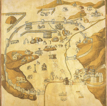
Alberti significantly described the advantages of plotting such monuments according to a radial grid by using “mathematical tools” to survey monuments by taking sightings from atop the elevated Capitoline hill. The finding of significant monuments on coordinates served to purify earlier travel books by selecting its authentic classical buildings, stripping away accreted legends like so many obscuring cobwebs, and creating a pristine media to understand the ancient world and the city’s physical plant. Although the rubric by which Alberti mapped the ancient city on top of the new one–the half-inhabited Rome of the recently returned popes–his intent was not only to replace the handbooks orienting pilgrims and visitors to Rome’s marvels but refine his admiration to a veneration of antiquity and the city’s ancient design, which he preserved in traces in its contemporary layout; his booklet may have provided a model for contemporary views of the ancient ruins in the city’s walls such as this Florentine fifteenth-century illumination from the workshop of the Renaissance mapmaker Pietro del Massaio, who made several maps of the region of Tuscany and of Italy that were destined for inclusion in a codex of Ptolemy’s treatise on world geography–an ancestor of recently undertaken efforts of digital archeology of the city. (The maps of Pietro were also known in several independent sheets, some of which are stored in the Vatican libraries.) But the city views that he included in the most precious codices were the most similar to the transcription of archeological highlights that Alberti, who sought to share his own passion for the antique with a generation of humanists with whom he corresponded in other Italian courts, had noted: they gave the monuments of the ancient world a new plastic form, and complemented the image of Rome–its coliseum a bit above its center, as seem below, but the Janiculum and Senatorial palace closer to the center–with images of other ancient Mediterranean cities, including Cairo, Alexandria, Constantinople, and Venice.
More than a hint of Alberti’s Renaissance resuscitation and incarnation of the ancient city in erudite terms was present in the view that Michel de Montaigne in later took in 1581 pf “studying Rome,” whose plant was at that point still two-thirds uninhabited, by climbing the Janiculum to “contemplate the configuration of all the parts of Rome, which may not be seen so clearly from any other place,” lamented “that one saw nothing of Rome but the sky under which it had stood and the plan of its site” with knowledge of the city only “as an abstract and contemplative knowledge of which there was nothing perceptible to the senses” since the world, “hostile to its long domination, . . . [had] broken and shattered all the parts of this wonderful body and, since even quite dead overthrown and disfigured, the world was still terrified by it, had buried its very ruins”–and lamented the lesser nature of “the buildings of this bastard Rome which they were now attaching to these ancient ruins.” These sort of maps preserved a city from its own decay, and created a powerful structure and physical design for mediating the past, as much as mark the situation of the city as a nexus of itineraries–such as the “Peutinger” chart (named for the Renaissance humanist who discovered it) depicted the city at the node of ancient Roman roads.

It’s interesting to think of Alberti’s booklet as an attempt to halt the burial of the past, or to excavate the lost history of a city whose buildings he had excavated and measured, but whose underlying plan was difficult to grasp: the techniques he offered provided not only a basis to draw one’s own version of the “map” of the city, but to internalize the ratios among its monuments, even for those who would not visit the site itself, at a time when the preservation of the ancient past gained new premiums as a model of urban planning. Alberti accorded the ruins a new language of wonder, and accorded a new wonder with the city that was associated with an unprecedented level of literacy with the map, using a graduated or calibrated circle reflecting his precision as an architect and classicist. It provided interested readers with practical instructions to create a reproducible map on the eve of the age of widespread circulation of printed images–images that no doubt encouraged subsequent humanist men of letters like Pirro Ligorio to create his own detailed mappings of the ancient city by the 1550s, as Flavio Biondo had earlier offered antiquarians a more detailed written geography of the ancient city. And it is the basis for projects of constructing an urban map of Rome’s monuments today by the same instruments. The role of these maps as validating the emerging antiquarians by setting standards of proficiency and expertise for interpreting and deciphering its ruins as they encouraged admiration of Rome as a unity in ways that undoubtedly served to lend far greater concreteness to its dismembered past. The distance of antiquity that one realizes in Rome today, accentuated by the proximity of its actual ruins, would provide Dr. Sigmund Freud in 1899 with a concrete metaphor for the simultaneous storage of multiple dispersed memories in the mind.
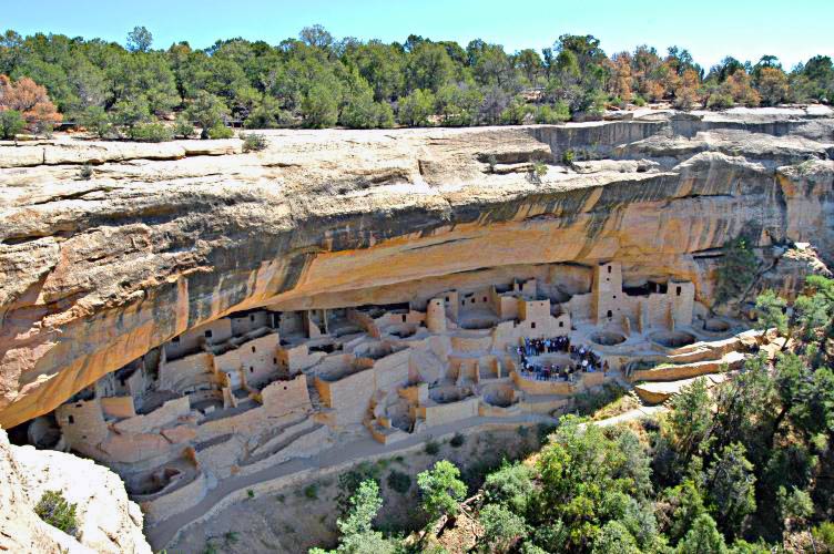
The medium is not always the message, but the personalized maps created by GPS (or, for that matter, Google Earth) dispenses with the intermediary of the cartography as a guide to orient viewers to a region. Rather than viewing or privileging the map as the vehicle for accessing the coherence of the past–or assembling a desire for such coherence–the map becomes a mode to access meaning and location, isolating the part from the whole, or the object from the context. And it may well be that the lack of coherence that we now have of our maps of ancient prehistoric sites in the United States is somehow informed by the media with we use not only to geo-locate but to pillage them. It is odd that GPS provides us with a new method for exposing and accessing the ancient world of the Americas in quite a different manner: if Alberti and Ligorio sought to provide readers a valued guide to antiquity, geo-location of Flickr images offer owners of GPS devices ready access to the coordinates of the cities of Ancestral Pueblos or Anasazi across the boundaries of Arizona, Colorado, or Utah–often to better pillage sites such as the cliff dwellings of Mesa Verde in Colorado, as well as to get access to the archeological heritage.
For the form of mapping that is used fail, unlike Alberti’s map, to preserve the sense of coherence that Alberti so prized, and that Montaigne sought to regain contact with, and, as such, preserved little sense of its fragility and cultural integrity as a patrimony. Those visitors who arrive with GPS devices in hand to navigate these prehistoric sites, David Roberts reports in the New York Times, not only observe their structures but often to take a piece of its ancient artifacts home with them–or might well carve their initials beside rock art panels, and indeed validate their locations by the coordinates they’ve downloaded, if not disturb their contents unknowingly in a region where pueblos of Anasazi are often beside evidence of later Hispanic settlers. One doesn’t need to be a Luddite to compare the relative poverty of meaning in most downloaded maps available online that promise ready geo-location of regions of Anasazi pueblos to the pilgrims to such sites.
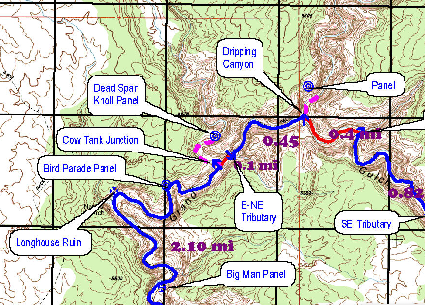
To be sure, the detailed topographic maps of the Anasazi lands provide accurate records of picturesque panorama for local hikers or explorers–if the routes of exploration are quite oddly rendered on websites as unfolded topographic map of the region, in which specific itineraries are highlighted on which one can track one’s elevation and descent, viewable as if an old USGS survey were extended before the viewer–but one that contains a far lesser level of density of meaning than that survey itself, whose legibility preserves but a fraction of the detail of the paper topographic map.

But most maps and handbooks they use to explore the sites offer few signs of warning–or cautions–that frame them as a site of similar historical or cultural significance, and the remains or objects that fill the site seem there for the touching, tagging, or taking. Even the above visualization conveys a sense of unfolding a privileged map of the region for foreground specific sites of interest and views, as much as to track their relative distance. Yet the users of this site, as Gary Gemberling, include imprecations enjoining readers to respect its integrity by advising them to refrain from vandalism and lack of respect for its original inhabitants, given the increasing use of trails as a form of prehistoric tourism and in situ observation of long-abandoned dwellings, formerly abundant pottery shards, in a tone that is all but absent from any earlier maps.
Here’s Gemberling, writing on the actually quite informative site of Jay David Archer, addressing visitors to the Anesazi ruins in Grand Gulch Park in Utah: “I’ve done this loop 3 times and every time is like the first, this loop i feel has the best rock art and cliff dwellings of the whole stretch, GET A MAP! its easy to walk right by some of the dwellings, i missed perfect kiva the fist time in, walked right passed it, and now my fav[orite] site, RESPECT!!! there is some vandalism sadly, its easy to disturb ruins, they are fragile, but you will learn this in the ranger station, you must check in,this place is like a outdoor museum, and its my church, i love it there more than any where in the world and i have been to 36 countries and 47 states, i have changed my life style to be able to go back here for many years to come, cedar mesa, monument valley, goosenecks park,bridges nat park and grand gulch is the jewel area of south east utah . . .” Yet the dense location of abundant wall-paintings or panels seem located on twisting path, with limited or little sense of their cultural uniqueness, even in the most detailed of maps of Jay Archer David, with limited signs of how best to negotiate its extremely fragile landscape:

The sense of entering a privileged space seems diminished, partly as a result of the media, but also of the very accessibility of the ancient sites. With GPS device and iPhone in hand, one compares where one is to the destinations others have already photographed, and which are readily downloaded from the internet and available as a sort of vicarious tourism that one can use to plans one’s own trips. There is almost a popular confusion here with the rise of GPS geolocation of seeking to commune with the past–or realize concrete contact with its ruins–by leaving a sense of one’s presence their, or view the site as a treasure hunt, which lacks its own integrity as a privileged place where ruins continue to be in situ and, as much as they will ever be, alive. If Alberti wrote a guide treasured by antiquarians, the accessibility GPS offers on exact coordinates allows a form of tourism without a sense of antiquity without any entrance fee save a GPS devices. The accessibility of the map, and, indeed, of multiple posted photographs of the actual site itself, does not mediate the past, but seems to create a sense of entitlement that apparently justifies removal of loot found at the end of the treasure hunt, or the prize of the pilgrimage. There is less of a sense of the marvel of the ruins as mirabilia with the transference to the Google Earth sense of wonder in the mappability of everything–and the problems of the accessibility of everything via photographs downloaded off smartphones and the GPS tracking of precise coordinates. Perhaps access to wi-fi could be limited or circumscribed in these areas of reservations, or national parks, in the hopes to preserve a sense of their wonders.