
Commemorating Christopher Columbus’ transatlantic voyages in a “discourse of discovery” has been magnified as they have become a bit of an exercise of collective remembering and of world-making. For Columbus monuments are less markers of fifteenth century voyages, than they serve to frame a range of narratives of discovery that promote the fifteenth-century navigator as an icon of nationhood that were foreign to the fifteenth century. In making claims for the foundational role that the navigator’s transatlantic voyage, they create a new narrative of nation, particularly powerful for its ability to occlude and obscure other narratives, and indeed the presence of local inhabitants in a region, so that they assume the deracinating violence of a map: as claims of possession, and indeed mastery over space, they dislodge nativist presence in a region, much as Columbus did as a royal agent, glorifyinf the acts of renaming, and taking possession of, the new world to ally the viewers with the heroism of the Genoese navigator’s foundational act of taking possession of the New World. The heroics posture of Columbus, until the recent spate of decapitated statues revealed a long simmering anger at the canonization of this figure as a founder of the nation, suggested a model of a white America, an erasure of indigenous inhabitation, and an outrageous lie.
Columbus set the basis for such grandiose claims, perhaps, by staking the transatlantic “colony” La Navidad as the first settlement by Europeans of the New World on Christmas. The event’s commemoration has continued in statuary across the Americas, even if the thirty-nine settlers left behind in the settlement were all massacred by natives after their ship, the Santa Maria, was dismantled after it hit a sandbar, and the men of the lost caravel that ran ashore on a sandbar off the island Columbus had auspiciously renamed Hispaniola, as evidence of Hispanic claims to sovereignty for his patrons, its hull and crossbeams converted to a fortress that was later burned to the ground. While the crew left with a translator who were instructed to collect a store of New World gold as they awaited his return may have been overzealous in courting natives that they were all killed, the extraction of riches and wealth and slaves motivated the New World settlement.
Yet in the commemoration of Columbus Day, the landfall has been renarrated as an inspired revelation of new lands, and allied with a sense of manifest destiny in retrospect, foregrounding the imperial mission of laying claims to new lands under the eyes of God. Yet the elevation of Columbus as a figure of state, and a westward course of empire, was magnified only in the nineteenth century. Paradigmatically, the painting of Columbus taking stock of his arrival by Dióscoro Teófilo Puebla Tolín, staged before uncomprehending natives cowering offstage, occurs as a missionary raises a cross on verdant shores where sailors triumphantly raised recognizable standards of the Spanish sovereign in the New World.

First landing of Columbus on the shores of the New World, at San Salvador, W.I., Oct. 12th 1492,
re-rendered by Currier and Ives, 1892/Library of Congress
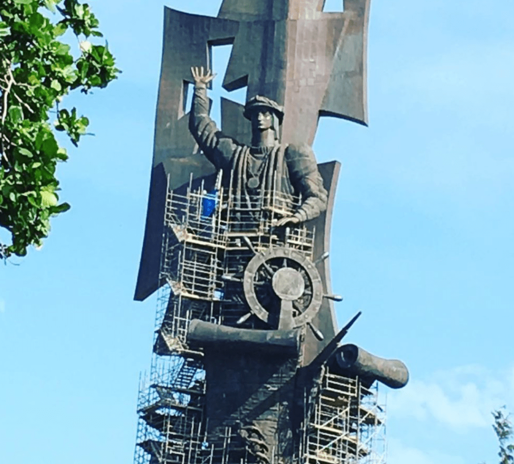
The bucolic image of arrival was cast as a triumph of technology, civilization, and deliverance. The bucolic scene not only denied violence, but was an image of paradisal promise that Dióscoro Teófilo Puebla Tolín rendered in a manner widely reprinted in the lithograph of the commemorations of quadricentennial celebrations of 1892 as a narrative of westward expansion of Manifest Destiny. The recent re-questioning of Columbian commemoration as a common national identity led to the questioning of commemorative Columbian statuary across the United States, from Columbus, Ohio to San Francisco to Kenosha, WI, to Miami. As the statues were dislodged from the common memories of an Italian-American community–as many once were in New Haven, Boston, and Philadelphia as well as New York City–their place loosened in a narrative of nation in ways that needs to be told. This was a narrative quite unlike how Michel de Montaigne bemoaned the manner Iberian voyages as occasions of devastation,and extraction had so needlessly left so “many goodly cities ransacked and razed; so many nations destroyed and made desolate; so infinite millions of harmless people of all sexes, races, states, and ages, massacred, ravaged, and put to the sword; the richest, the fairest, and the best part o the world topsy-turvied, and defaced for the traffic of perils and pepper.” Montaigne’s deep discomfort wit the global catastrophe that was driven by greed cerated an economic and epidemiological devastation in their wake were substituted by a massive hulking bronze Columbus, standing as if a champion of Christianity that would be a gift from Moscow’s mayor to the “free world.” Driven by increased recognition of the truly genocidal destruction of indigenous in the moment of contact, the term “genocide”–long reserved for the Holocaust but increasingly applied to the destruction of indigenous peoples in Guatemala, Bolivia, and Argentina in Latin America–led to the recognition that Columbus’ unqualified heroism needed to be qualified.
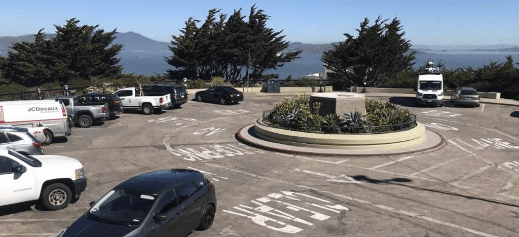
It was in this context that the monument of Columbus that Trump mediated as an erasure of the collective memory and of the past in the americas. The burst of creative iconoclastic energy directed to statues of Columbus left San Francisco’s City Arts Commission preemptively removing the monument to Columbus overlooking the Pacific from its monumental pedestal in order to maintain the local peace–a statue long defaced in recent years–before it was defaced. The recent removal of monuments to Columbus spread as a re-tallying of moral accounts, but a restoration of civic peace. The importance of refiguring the commemoration of colonization grew as a form of reparations whose logic was unmistakably national in character,–if the first questioning of Columbus Day had been local and selective in 1992-3.
The deposition of the 4,000 pound bronze statue of Columbus to a holding container channeled the rejection of the figure of Columbus whose monuments were already deposed in Boston, St. Paul, Minnesota; Camden, NJ; Richmond, VA, and other cities in New York state, one of which was beheaded–if long after the statue to the navigator was ceremoniously pushed into the ocean in 1986, in Port-au-Prince, Haiti, with a placard “Foreigners out of Haiti!” And by 2020, the ease with which statues of Christopher Columbus were assimilated to the confederate monuments preserved across many southern states–and preserved at considerable cost to American taxpayers–reminded us of how easily the memory of Columbus as colonizer was cultivated among white supremacists as iconic testaments to a sense of historical security of another era we were trying to pry ourselves free in hopes to gain distance on. Even if the statues of Columbus and Columbus commemorations are overshadowed by the razing of the statues of Confederate generals in recent years–


Confederate Monuments Removed since George Floyd’s Murder
–the images of the dicsoverer were dismantled as we engaged a contested legacy. If monuments removed with an eye to toppling racism across southern states that had commemorated secession in the attempt to defend enslavement and chattel slavery were a stain on the nation that emerged like a return of the repressed in the summer after George Floyd’s murder by overly zealous “law enforcement” forces, the removal of monuments had begun as undeniable evidence of their talismanic status as lodestones for white supremacy became clear after violence in Charlottesville directed attention to the degree to which commemoration of the Confederacy kept a memory alive in national and local consciousness, revealing how undecisive the Civil War was for the preservation of local memories across many border states or secessionist states, and the toxic nature of preserving memories of southern secession as a defense of what were cast as local liberties within the union.

The division assessment of historical legacies that shape a narrative that informs the present landscape of inequity had been contested for decades around the heroicization of the figure of Columbus as a shared national point of reference. As much as the seven hundred and eleven standing monuments of commemorating secession–over 1500 statues which are collectively preserved by taxpayers’ money at a cost of $40 million for annual upkeep. The standing statues dedicated to anti-abolitionist figures have kept the memory of the Confederacy alive across the United States, including of Jefferson Davis and Robert E. Lee in Virginia, Georgia, North Carolina, and Texas, creating a topography that has inflected political identities.
Donald Trump was savvy if hateful to tap this energy of amnesia, during his first Presidential campaign in 2016. He re-presented himself as an incubus already planting seeds across the land, many of which were only removed by energized (and disgusted) protestors or whose remove was ordered by city councils in an attempt to preserve the local peace–including of the unidentified heroic “Confederate soldier” who removes his hat in downtown Alexandria, VA, removed only in June 2020–if similar statues remain in Jacksonville FL, and San Antonio TX, heroizing as if sanctioning the very option of local resistance to according rights to enslaved populations, beyond preserving memories of war dead. The confederate statues were long mythologized as an alternative system of justice, echoing the reduction of rights and civil equality across the landscape by holding up a distorting mirror of Southern victory and secessionist pride, gaining legs as grounds to advocate an outdated status quo reflective and constitutive of an alternative order unto its own, as is evident in the naming of courts of law after Confederate names.


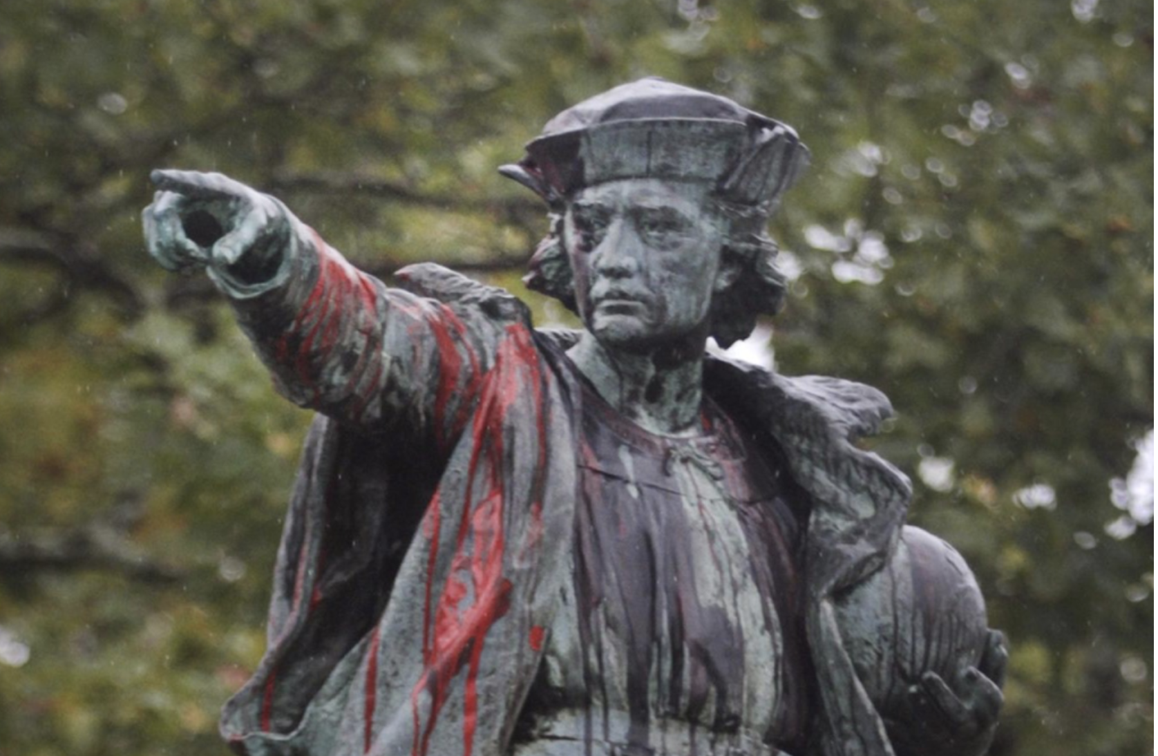
The spattering of blood on Columbus memorials call for a revision of public memory complicit in a culture of spatial colonization that perpetuates the fundamental nature of racial hierarchies. The requestioning of commemorating the act of violence as fundamental to the nation’s values is a questioning of their place in civil society, and their meaning to the nation, motivated in no small part by the ugliness with which they have been seized with new currency as images justifying a racial superiority and sanctioning the violence of enslavement along racial lines. For their removal had tried to call attention to the dangers of commemoration by targeting the figure of Christopher Columbus, whose statues had first multiplied across American land in roughly the same era of the later nineteenth century, following Confederate statues, in a sort of monument trick that served to naturalize white possession of indigenous lands.
The overturning of commemorative statues of the fifteenth-century navigator so deeply dissonant to our sense of national belonging, common memories, redressed disturbingly long-lasting spatialities–the average statue was almost a hundred years old–as the nation entered a temporal loop of recursive nature of reparative bent, as the destiny Columbus imagined for himself as a civilizer and discoverer of a New World–and new continent–emerged in increasingly pressing ways, opening up the very speech act of taking possession of the Americas as a fiction, only masquerading for utilitarian ends as a binding legal precedent. For only by confronting the painfully exclusionary nature of such an act of taking possession, deriving more from the practices of enslavement and mastery of others that run against the very basis of our own civil society, or the civil society we seek to create.
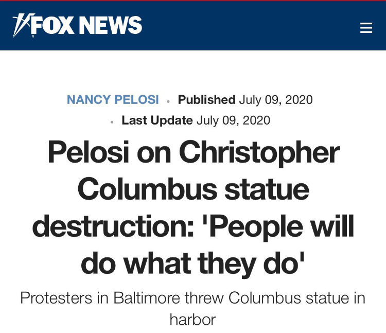
Indeed, the San Francisco’s 4,000 pound commemorative statue of Columbus, often defaced as a symbol of enslavement and subjugation in recent years, was removed by a crane and as a call to dump it into the Bay was circulating, on Thursday, June 18, removing it from a scenic site by the Pacific beside Coit Tower, leaving an empty pedestal, perhaps to reduce the need to clean up a statue that had been repeatedly defaced in recent weeks but also to show consensus about lack of interest in defending a symbol of oppression, enslavement, and colonial violence, and public outbreaks around the call to depose the statue off Pier 31, not as a symbol of colonial resistance, but an expunging of the navigator from national history. All of a sudden the dismantling of public memories of Columbus’ heroism were national news, a divisive issue responded to not with understanding but professed shock for besmirching American history, not reassessment of values, battling Italian-Americans Nancy Pelosi herself as forsaking, as if to bemoan her betrayal of the preservation of the hallowed memory of Christopher Columbus in the summer of 2020 to stoke lines of political division in the heat of the 2020 Presidential campaign: the fate of the statuary of Columbus was a bell whistle for stoking fears of a danger to the status quo.
It was as if the spontaneous prominence across the nation of memorials to George Floyd, proliferating on street walls in full color, and in haunting offset likenesses, provoked introspection demanded introspection of what sort of memorials we identified with and wanted to see the nation, placing on the front burner of all the question of commemoration in terms that had long been glossed over and tacitly accepted. The questioning of commemoration after Floyd’s murder came to articulate a spontaneous rebuke of the continued validation of racialized policing and police violence, throwing into relief discriminatory monuments. There were soon few defenders of the monument able to tolerate how they emblematized division of the social order, eager to ask us to situate Columbus more broadly rather than historicize his complicity in “some of his acts, which nobody would support,” without addressing the framing of the logic of “discovery'” in imperial narratives of conquest and disenfranchisement of indigenous claims to sovereignty and to recognize the need for reparations.
For the navigator embodied an imperial relation to space and terrestrial expanse, discounting the inhabitants of regions, and affirming the abstract authority of sovereign claims and sovereign expanse, however improbably early maps placed the islands in the Caribbean–later called Hispaniola–based on his conviction that the Atlantic Ocean was able to be traversed, enabling transatlantic voyages for which Spain was well poised to expand commerce far beyond the coast of Africa and the Mediterranean for economic ends in an “Enterprise of the Indies” that Columbus proposed to John II of Portugal, before he set out to claim the new lands for Ferdinand and Isabella. The longstanding embedded nature of Columbus in a discourse of claiming land–a discourse from which he was not only inseparable, but embedded maps in claims of the administration and supervision of lands far removed from seats of terrestrial power, a map-trick that has been celebrated since as a form of inscribing territorial claims on a piece of paper or globe.
And if Columbus had no actual idea of the form of North America, the persuasiveness of fictive reimagining of his mastery over space–a mastery cast almost uniformly in intellectual terms, rather than in military terms of disenfranchisement or enslavement–provided a logic that is aestheticized in the monument as a mode for the possession and persuasion of possession over terrestrial space more akin to American hemispheric sovereignty in its open heroizing of a national geopolitics of the 1890s than to a Renaissance discourse of discovery–comparable to the reimagining of hemispheric sovereignty in the years after the 1867 withdrawal of Spanish sovereignty to Mexico.
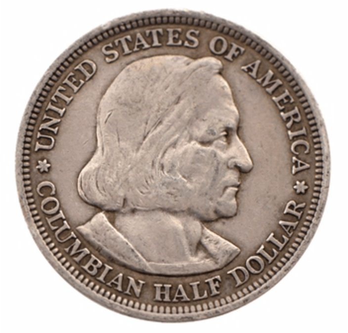
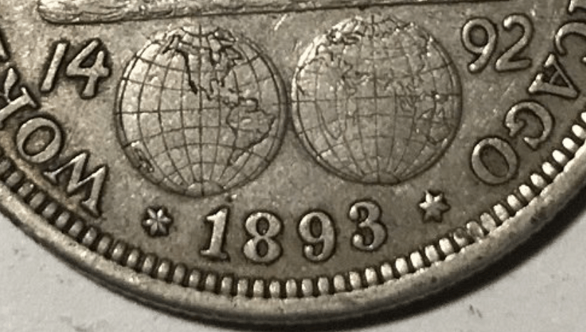
The origins of these reframing are perhaps obscure, but lionizing Columbus was always about rewriting the American narrative, and distancing one race of immigrants–the Italian migrant–from the very native inhabitants that the story of Columbus displaced. The navigator was promoted actively as a figure of national unity in the post-Civil War centenary of 1892, in which Columbus assumed new currency as a national figure, a map on silver able to enter broad circulation as a memory for how a three-masted caravel mastered terrestrial expanse, resting above a hemispheric map of global oceanic expanse. The anachronistic map suggests as much a modern triumph of hemispheric cartography–the coastline of the United States was surveyed by geodetic terms and that established the role of the United States Coast and Geodetic Survey in producing maps of uniform toponymy and hydrographic accuracy had only recently set standards of coastal surveying that unified triangulation, physical geodesy, leveling, and magnetic of authority within the US Navy to produce coastal maps of the nation extended from the Gulf of Mexico to the Alaskan shoreline.
The imperious gaze of the limp-haired navigator seems the first self-made man as he gazes with gruff determination on the coin’s face, almost entirely filing the surface of the first American coin bearing human likeness. Columbus was an icon it identified with how the hemispheric map took charge over a continent, and gave a sense of predestination to the recently settled question of continental integrity–and a territorial bounds that new no frontier up to Alaska, whose coast had been recently surveyed, and much of Florida and the Gulf of Mexico. Its design for the Chicago Word Exposition suggest a hemispheric dominance reflecting the growth of Rand McNally in Chicago, a map-publisher for America, as well as the self-assertion the United States as a hemispheric power, as much as the Genoese navigator about whom so many meanings have encrusted.
The striking hemispheric map of global navigability on the obverse of the coin circulated in Chicago’s World Exposition was global, but would also mimic the claims of hemispheric dominance that the hemispheric projection recalled, prefigured the Pan Am logo, in its global in reach–as if the image of a spherical projection devised by Rand McNally that spanned the globe and erased all borders might be cast as the seedbed for globalization was itself contained in the transatlantic voyages of the small trade ships, the Pinta, Niña and Santa Maria that were led with hopes of a profitable economic voyage with Columbus at the helm. (Rand McNally had not only sponsored the world’s fair, but its double spherical projection that recalled Columbus’ conviction of a spherical world by ahistorically featuring a cartographic design Columbus would have known; the planar projection was an icon of global expansion and conquest, more detailed in coverage than late seventeenth century double spherical projections.
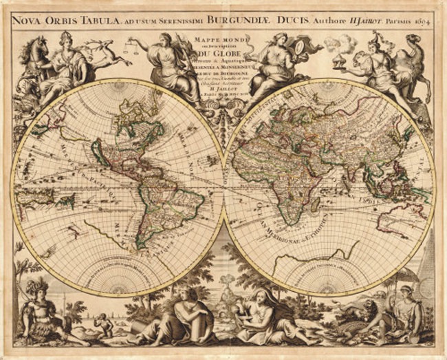
–but devised and issued its own elegant version of a world map based on the Mercator projection in following years from 1895, in atlases issued subsequent to the World’s Fair, to meet a growing market for global maps. Leaving much of the African interior unmapped, in a manner that cannot but recall Conrad’s Heart of Darkness, the image is a confirmation and announcement of global triumph, centered on the North American continent and United States, if it shows the world.


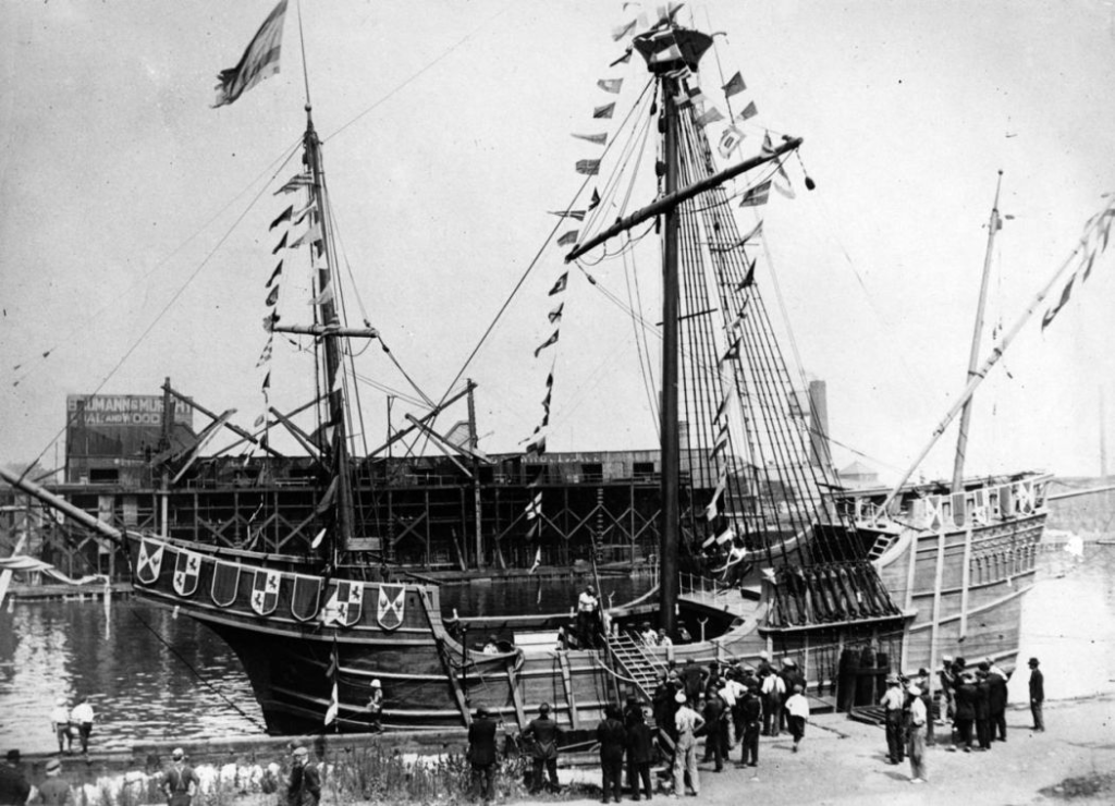
In 1893, the point was made as replicas of the Nino, Pinto, and Santa Maria sailed in Lake Michigan during the Centennary, for which the U.S. Congress approved the printing of the first commemorative coin of an individual, beer flowed on tap at what was celebrated as a “blueprint of America’s future,” foregrounding the technological supremacy of the West and America. Ehe figure of Columbus was assimilated to the new technologies of transportation and conquest in a new center commerce where railroads open onto the west, in a condensation of a national celebration that cast Columbus as a figure of the destiny of western expansion, indulging in an American hyperbole of incandescent lighting, the championing of new technologies, in which the replicas of the Pino, Nina, and Santa Maria that had sailed from Spain were again sailing on a landlocked Lake Michigan were exhibited to foreground, Gokstad Viking ships sailed the flooded Midway, beside the mock-Venetian crafts of gondoliers.
Such global mariners provided a flourish within a World Exposition whose stage sets and soundstages, P.T. Barnum like, celebrated transit, transport, and mobility to astound visitors and silence all questions of not presuming to celebrate four centuries of progress; the neoclassical facades of buildings as the Administrative Building, Palace of Fine Arts, Agricultural Building, and Court of Honor, were iterations of the Crystal Palace that were precursors to Las Vegas, proclaimed the birth of a “White City” at the World Exposition that promoted the figure of Columbus and was under-written by the federal government and corporate America, recasting the shady city of vice as the “White City.”
The claiming of Columbus as a national figure in the rebranding of the World’s Exposition set in neoclassical buildings as the site to celebrate Columbus recreated the l’Enfant architecture of the District of Columbia, and elevated the city as “white” in some of the very issues that make the continued celebration of Columbus Day so fraught in a pluralistic society: Peter van Der Krogt has surveyed in striking detail some four hundred monuments to Columbus that were erected after what was called the “World’s Columbian Exposition” in 1892-3, a century after the first monument to Columbus was built in Baltimore, in 1792, what it meant to identify Columbus as American, if not name the nation “Columbia”–the popularity of these monuments in New Jersey (32), Connecticut (15), and New York (24) suggests the clear lack of uniformity of enthusiasm of celebrating the navigator’s equivalence with the nation, in counterpart to the Confederate statues overwhelmingly erected in the 1890s across southern states, with the rise of an ethnocentric nationalism that would blossom to anti-immigrant feelings in the early twentieth century.

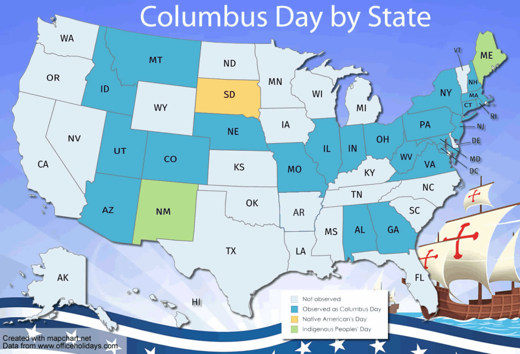
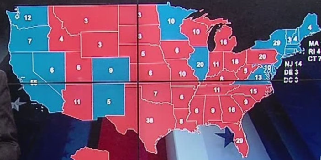
The fraught question of celebrating the Genoese navigator became a hot-button topic for Donald Trump to rally red state voters–“to me, it will always be Columbus Day!”–and to serve as clickbait as part of the new, perpetually churning culture wars. In an October state meeting with Italian President Sergio Mattarella, Trump was pleased to note that while “some people don’t like” the continued commemoration of Columbus’ transatlantic voyage, “I do”, as if that should be sufficient for the nation. Prime MinisterMattarella’s state visit became an occasion to espouse public disdain for the renaming of the national holiday as Indigenous Peoples Day, if not Native Americans Day, in over 130 cities across 34 states. For President Trump, doing so seemed designed not to impress Mattarella, but define a wedge in a deeper cultural urban-rural divide– a yawning divide of economic opportunities, the knowledge economy, and the shifting horizons of economic expectations, more than political belief. The nature of this poorly mapped landscape, the thin substrate of uneven economies and cultural disjunctions and divides, that passes as a political in a datamap of the district-by-district voting preferences that rips a red continuity all but from its bordering blue frame.
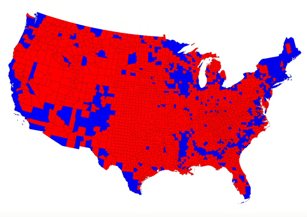
The national discontinuities reveal an impoverished geographic sense of meaning, one that makes all but ironical the prestige placed on the legibility of the map by the legendary figure of Columbus, who never set foot in the continental landmass now known as the United States, but was, in an era of increased hemispheric dominance of the quatrocentennary nearly engraved map–a reflection of the prominent role Rand McNally played in the organization of the Exposition of 1892, promoting the prominent place that the mapmaking company had gained in the design, dissemination and marketing of instructional printed maps in the later nineteenth century, just a decade after the Chicago-based printshop primarily producing train time-tables expanded its role in a growing educational market for globes and printed wall maps, using its engraving methods emblematized in its dramatic bird’s-eye view of the exposition.

And although it did not design the commemorative silver half dollar that included a caravel of the Santa Maria moving on creating ocean waves above the very anachronistic map that suggests the continental expanse of North and South America–as if Columbus’ guidance of the historic transnational voyage in three caravels he captained was based on a mastery of modern cartographic knowledge. The clear-sightedness of the navigator below the legend “United States of America” linked fearless scrutiny of the global expanse to the foundation of a nation, as the coin designed by the U.S. Mint sough to give circulate a discourse of national unity in the first coin printed in the United States to include the likeness of an actual individual, after hopes to copy a Renaissance portrait by Lorenzo Lotto were replaced by an austere profile suggesting intellectual grasp of space to be sold as souvenirs to visitors of the national fair. Yet the notion of hemispheric dominance was not far off: the explosion of the American naval frigate in the port of Havana led to charges to attack Spain in the press to exercise dominance ridiculed in the Spanish press–
The hint at hemispheric dominance in these maps mirror a push in the 1890s against how “the self-imposed isolation in the matter of markets . . . coincided singularly with an actual remoteness of this continent from the life of the rest of the world,” as a shift in global governance and prominence; the earlier celebration of the continental expansion of the United States to an area “equal to the entire circumference of the earth, and with a domain within these lines far wider than those of the Romans in the proudest days of their conquest and renown.”
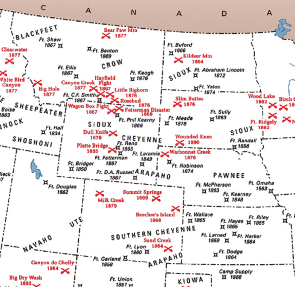
Casting nationalism in such cartographic terms mirrored the embedding of Columbus in legacies of nationalism and colonization,–the coin that gave the navigator currency, if it silenced the recognition of the other, presenting Columbus as emblematic of a conquest of space. At a time when Italians were regarded as of different status from other whites, the figure of the Genoese navigator became a lens to project the “white” essence of the territorial United States in quadricentennial celebrations of 1892, recasting the navigator as an unlikely and implausible hero of the white race at the culmination of claiming native lands within the bloody landscape of Indian Wars–roughly, from 1860 to 1877–and to erase the violence of the seizure of these lands to crate the new map of the West, remapping the western lands “as” legible Anglophone and American, and the province of the White Man. Was Columbus the improbable hero of such whiteness and the claims of whiteness in the quadricentennary celebrations that led the nation to celebrate a “white” Italian, as a figure of the whiteness of the nation?

If we are realizing the loaded nature of the erasure of earlier inhabitants in the celebration of arrival in ‘America’ as a prefiguration of the nation, the condensation of this genealogy in the coin of the quadricentennial was a celebration of the witness of the national nd legibility of the new continental map map.
For as ethnicity was understood in sectorial and distinct terms of labor in the late nineteenth century–erased by the notion of an “end of ethnicity” and melting pot of the late twentieth century–the image of Columbus as a “white” hero, the image of the discoverer was purified of his own ethnic origins, at a time when negroes and Italians were excluded from social orders, and lived in Chicago sequestered in enclaves like Little Sicily, or Five Points in New York City, President Benjamin Harrison in 1892 promoted Columbus Day as a “one-time national celebration” to quell international tensions after lynching of Italian-Americans in New Orleans’ Little Palermo between Italy and the United States: the image on the commemorative coin of a pacified globe of continental unity as if it were included in Columbus’ fashioning of his own prophetic identity affirmed Columbus’ whiteness, as it erased the identity of indigenous subjects and silenced the other.
Columbus was promoted eagerly to claim whiteness for Italian-Americans, as well as to define a non-indigenous figure of the nation and national pride. Long before Italian-Americans adopted the festivities of Columbus Day as a regular celebration to incorporate their centrality in a civic record of national identity, as New York Times editorialist Brent Staples has put it, purged of racial connotations that continued in the popular press, only after the celebration of Columbus Day opened a pathway to integration in the face of racialist slurs. As those Sicilians who segregated in their dwellings in New Orleans were seen as targets of racial persecution, and as northern newspapers used stereotypes continued to magnify charges of poor hygiene and linguistic differences, casting Italians as vermin unfit for public schooling, Columbus provided a figure to flee from dispersion as a “Dago”: as immigration from Italy faced official restrictions by 1920, and Italian immigrants were subject to at the start of the first great Age of Mass Migration, as Calvin Coolidge barred “dysgenic” Italian-Americans from entering the country.
In the very years wen immigrants were both sectorized and accorded new status as “whites” who were eugenically suspect, and rates of immigration were slowed under the banner of eugenics, the figure of Columbus proved an able image to launch a powerful agenda of alternative immigration reform: in the very regions where the share of population of Italian origin was most pronounced by 1920, in those very counties the erection of Columbus monuments grew. They appeared in interesting fasion from the eastern seaboard inland to the Great Lakes, into the Chicago area on Lake Michigan, to the Texas and Lousiana seaboards, and San Francisco area in northern California: the dispersion of Columbus monuments across the nation below lacks dates,–
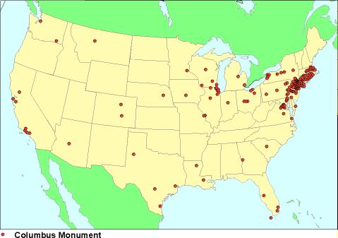
–it is a striking reflection of what U.S. Census records reveal about the relative proportional concentration of Americans of Italian parentage in the United States in 1920, when the Census tabulated those identifying as of Italian parentage as a category.

The increased transatlantic migration that occurred around the 1920s could recast the topos of overseas arrival as embodied by Columbus. The figure of Columbus as an intellectual, a civil servant, and of the statue as a monument of civic pride all encouraged the appearance of the navigator in public monuments. Of course, they recuperate the image of the placement of the flag of authority overseas, as much as vanquishing native one of the first global maps, planting the flag of authority overseas.
Was a reckoning of sorts apparent in the opposition between Columbus and Nancy Pelosi as two vision of Italian-American heritage–cast as loyalty and some sort of betrayal–that was broadcast on FOX News? “If the community doesn’t want it, it shouldn’t be there,” Nancy Pelosi responded to the toppling of a statue of Columbus in her native Baltimore, attempting to remove pride in her Italian-American heritage from a statue, but the war of statuary increasingly became about orienting one’s place in the world, and the effectiveness of Eurocentric notions of “discovery” as a way of gaining bearings on the diverse population of the United States.
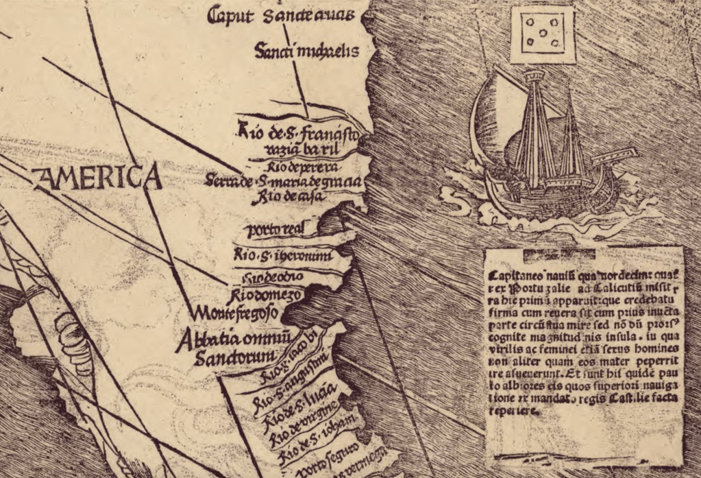
The question of such exportation of royal claims was a truly cartographic problem: the spatial migration of Portuguese royal authority was seen in Martin Waldseemüller’s 1514 printed global map as a pair to the discovery of a Spice Route around by Vasco da Gama. overlooking and surveying coastal toponymy in a statuesque manner, bearing the figure of the flag and cross as an ambassador of the most Christian regal monarch.
The oceanic voyages of Vasco da Gama, as of Columbus, were seen as those of an emissary of royal authority, whose travels recuperated tropes of imperial migration that derived from early church history, and were given new lease in the Holy Roman Empire by imperial chroniclers and pre-Colomban universal histories, as a spatial migration of imperial authority: in maps, the Christian migration of royal authority over space, along rhumb lines and nautical travels born by sea monsters who embodied the oceans, was a repeated topos of cartographic tradition not initiated by Waldseemüller,–the cartographer who named the continent after the Florentine navigator and mapmaker Amerigo Vespucci–

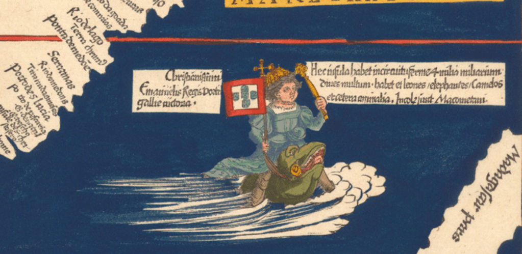
–and would echo the prophetic cast Columbus had assumed in his letters, and would give as he cast his exploratory voyage in terms of one of renaming, conquest, and discovery, rather than exploration, as he cast himself as acting as of an emissary of and invested with authority by the monarchs of Spain, and a delegate of royal sovereignty who had himself moved across the map to lay claim to unknown islands that he named after his royal patrons.
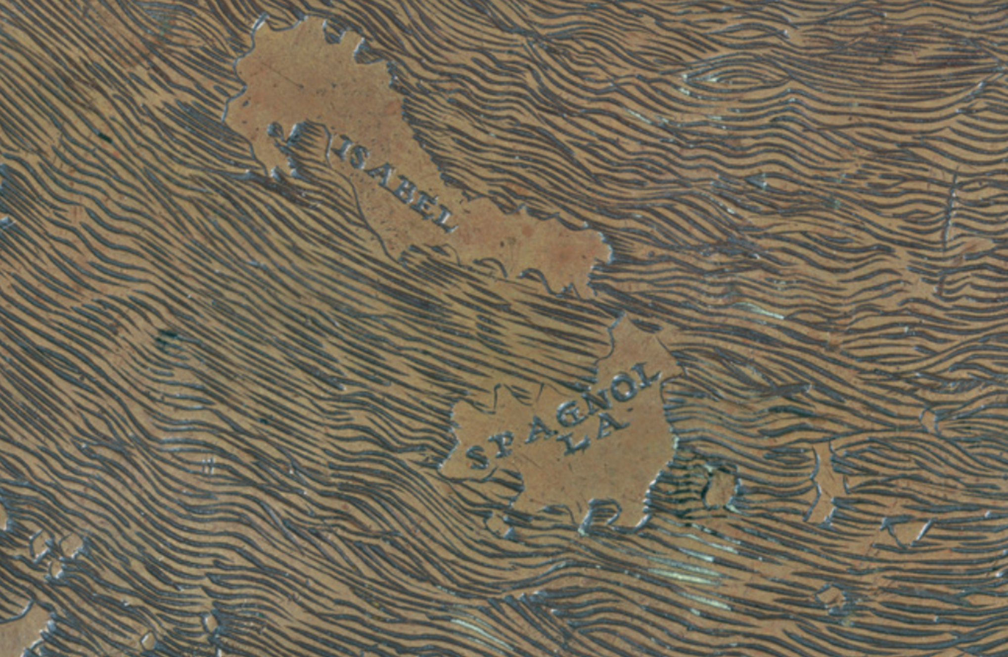
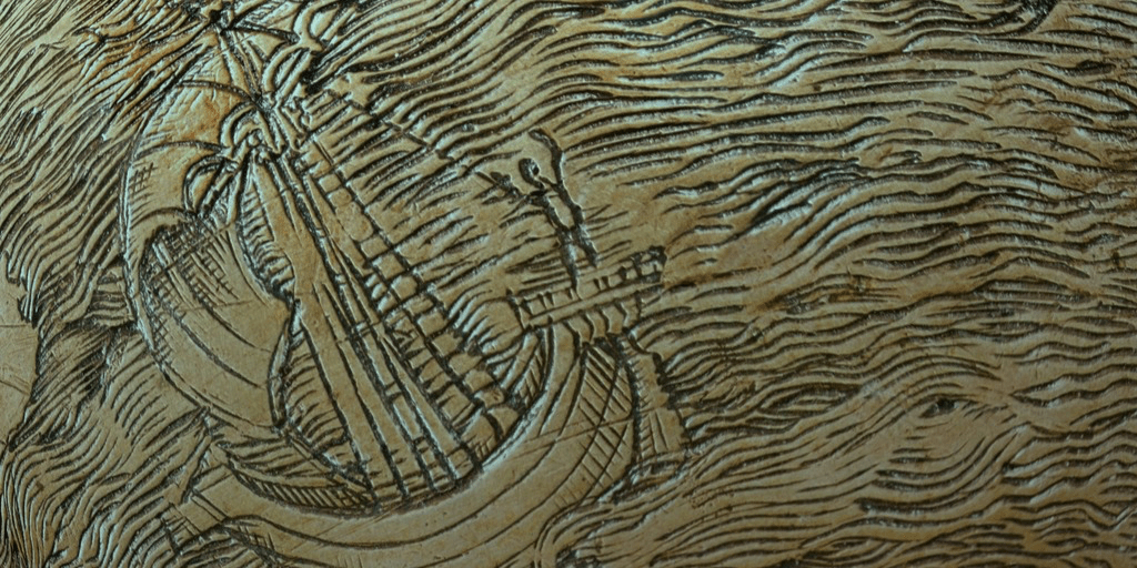
The naming that was cast as emblematic of civility and civilization of new lands, and of the new naming of the Land. Indeed, the privileging of the effects of cartographic literacy were felt in the Waldsemüller map. by its foregrounding of the cartographic prominence of the insularity of the lands of discovery, greatly magnified in Waldseemüller’s map to reveal the prominence they held in the European imagination as a revision of Ptolemaic geography, the islands alone doubling the territoriality of the Spanish monarchy–by expanding it to a transatlantic set of islands that were cartographically inflated in size, and not only to accommodate the toponym “Spagnuola” but magnify the scale of the discovery. If the band East of Eden sing, in Mercator Projected, declare over the strong guitar strums, “It’s in the Western Hemisphere/that’s where the nicest things appear,” Mercator effectively magnified the very same hemisphere as the cartographic expansion that doubled the demesne of Spanish kings, cleansed of all of its indigenous inhabitants.
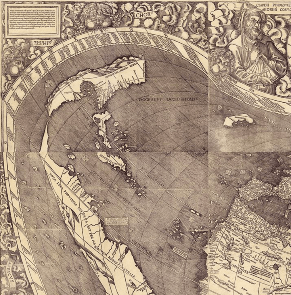
The discovery of course altered the scope of Spanish sovereignty, as much as the cosmography Ptolemy set forth based on the astrolabe he proudly held in the upper right of this twelve-sheet wall map. In this fractured world of multiplying insular fragments, where the entire of the modern South America, here island-like, if immense, labeled “America” and below the island of Hispaniola, was “discovered by the command of the King of Castille”–island-like as Waldseemüller most likely was forced to add the to the pre-1491 global maps that perhaps remained his source–dotted with even greater abundance of islands, all acting as if beckons to potential sites of untold wealth. The figure of Columbus may be absent from the map, but the caravel identified as sent by the European monarch seems to provide the basis for information in the 1507 global map–where it seems as if the emblem of Columbus–
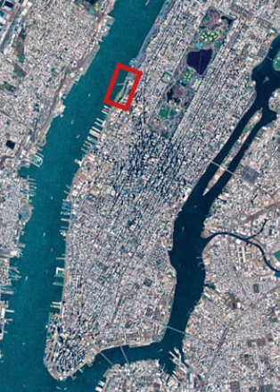
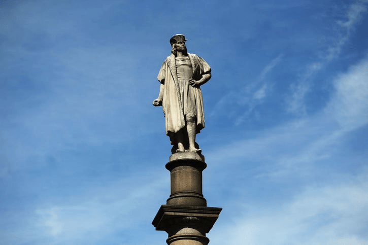
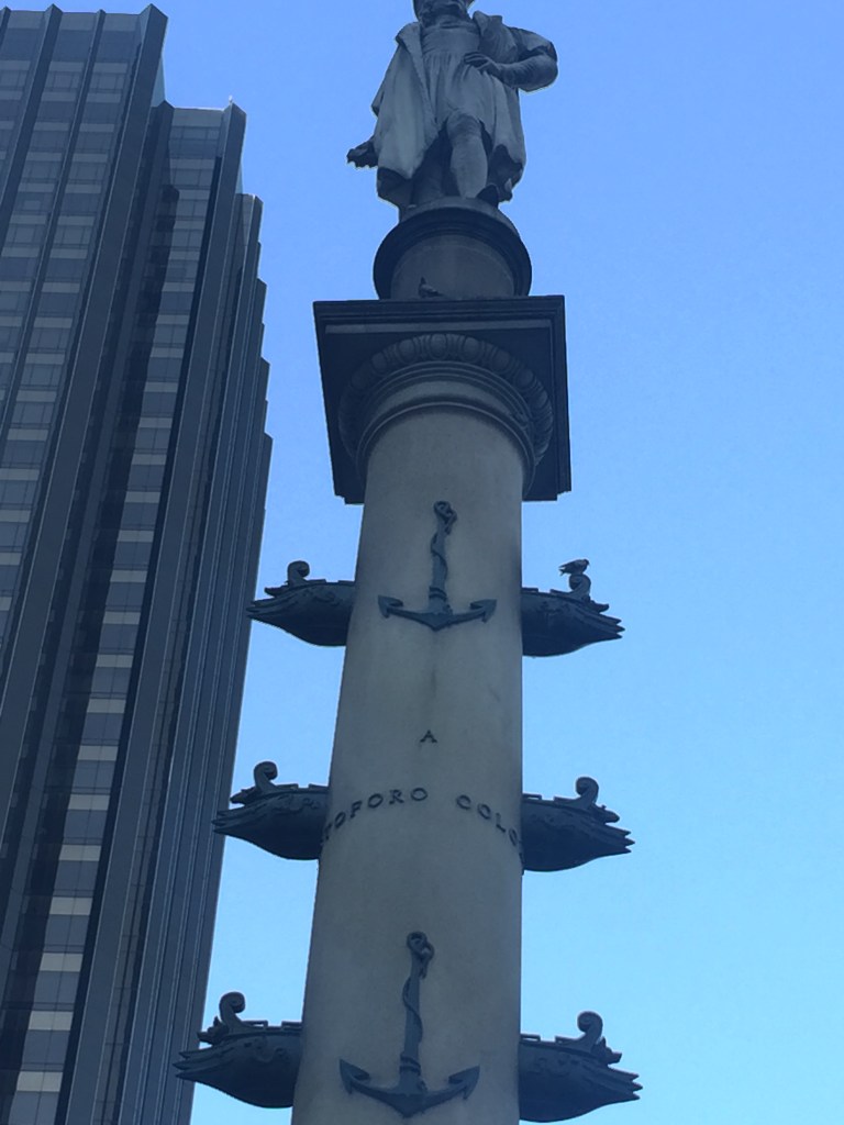
I found myself recently standing in New York City’s Columbus Circle, a towering column constructed shortly after the erection of the Liberty statue in New York harbor, it was hard to imagine how the towering figure of the navigator once stood above the circle.
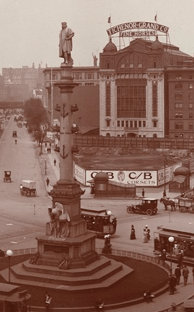
The prominence this late nineteenth-century Columbus claims atop a pedestal before a shop of corsets is a bit comical. The 1892 statue must have been a reply to the lady who stood as a welcome sign to recent waves of immigrants; funded by the Italian language newspaper that had begun publication only a decade earlier in 1880, the monument to the Italian navigator’s discovery served as a proclamation of civic dedication as well as rected; the encounter was monumentalized as an auspicious arrival of a man who seems to proclaim the New World’s settlement before a group of shrinking natives, who retreat behind foliage.

The statuary made in Rome during the centenary of 1892, seemed intended as a moment of immigrant pride, and indeed identify the navigator as an Italian navigator, unlike the native inhabitants who seemed unclothed and barbarous. The statue of Columbus Circle stood facing to the south of Manhattan island, as if in rejoinder to the midwestern Columban exposition that celebrated the expansion of Chicago and the opening of an American West. The contest between the monuments aspiring to announce the New World back to Europe demands to be teased out, but played out over the next century.
The icon has defined the southwestern corner of Central Park, and as a monument of triumphalism has, even if it has been dwarfed by the nearby Trump International and, since 2003, the Time Warner building, the once soot-covered statuary had a prominent civic function of rehabilitating one immigrant group, if perhaps at the costs of denigrating others and promoting a dated form of patriotism. The reduced place of the smaller Trump property may now seem in the shadow of the far more monumental Time Warner complex, but Trump had already aspired to displace the tower of Christopher Columbus as he wanted to put his own imprint on the New York skyline before 1992, and readily adopted the Columbus centennary as a pretext to demote the Columbus Square column at the same time as he promoted his vision of a Trump City by the Hudson River banks, for which Columbus became a pretext as much as a backdrop of sorts.
But is it a surprise that as a New York realtor eager to dodge financial ruin in the late 1980s, Donald Trump boasted of plans to erect an immense statue of Christopher Columbus in 1992 by a Russian sculptor, Zurab Tseretelli, shortly after the fall of the Soviet Union, from a massive $40 million of bronze. The statuary framed as a gift from Moscow’s mayor to the New York mayor, Rudy Giuliani, to rival that of Columbus Circle must have been a massive tax write-off of the sort Trump had specialized. And grotesquely, the statue revealed, far from patriotism, the deeply transactional legacy of linking Trump’s developments to the nation, whose grandiosity of re-monumentalizing Columbus–Trump boasted the head made by the Russian sculptor Zurab Tsereteli from $40 million of bronze was already in America–“It would be my honor if we could work it out with the City of New York. I am absolutely favorably disposed toward it. Zurab is a very unusual guy. This man is major and legit.”
The grandiose claim is classic Trump, designed to feign disinterest and patriotism but searching for fame. Zurab, a prominent member of the Russian Academy, mighthave been quite legit, but building the massive bronze statuary was also a huge tax dodge to be built on Trump acreage, whose immensity only made it more valuable as a dodge and gift to the city of the sort one could write off but was also an investment inflating the real estate’s value: which Trump presented as a done deal accepted by then-mayor Giuliani as a “gift” from the Mayor of Moscow, mediated by the patriotic developer who had secured the landfill as realty he sought to boost before he built. The statue reveals early interest of the transactional nature of exchange and inflation of value, which long animated the Trump brand.
The quite hideous statue, whose head had arrived in New York, was rejected for reasons unknown. The rejection was perhaps not aesthetic alone, but as the immense complex of figure and naval vessels, eventually recast as The Birth of a New World when the complex was finally installed on the coast of Arecibo in Puerto Rico, weighing in at 6,500 tons, in 2016, was hardly designed to be sustained by landfill: what piles into the Hudson’s banks would sustain all that bronze? The dedication of the statue at the year of Trump’s victory in the Presidential election was not planned, but is oddly telling. The gaudy if not hideous monument was rejected flatly first by New York, and then by Miami; Columbus, OH; Baltimore; Ft Lauderdale; and lastly Cantaño, Puerto Rico, where it faced intense local opposition, from the United Confederation of Taino People given their conviction “Colombus was a symbol of genocide, not a hero to be celebrated” by monumental statuary in the nation’s public memory.”
The collective reaction of the grotesque figural complex may have arisen because of effects on the community, but the body of the statue was recycled as it was transformed by Tseretelli, rumor has it, with a new head as Peter the Great, for Moscow, that celebrated the tsar for founding–yes–the Russian Navy. The monument that was the world’s eighth largest piece of global statuary at 93 meters voted was voted the world’s tenth ugliest buidling. The this 81 meter animated statue beside an oddly raised arm of greeting evidence that it was indeed remade in an attempt to match the massive body of bronze that remained in Moscow in 1992, or was the mismatch due to a new fashioning a body for the head returned to Tseretelli’s studio the became a monstrous monument of eery import? T eh odd disconnect of head and body seems not an illusion of perspective (witness those huge shoulders), but seems evidence of some sort of switcheroo in statuary that Tseretelli or his assistants bungled.
The image that we can entertain of Donald Trump transactionally pedaling Columbus from shore to shore tragically concludes the triumphalit Columban statuary–who better to pedal dated triumphalism? How did the Columbus statue ever arrive at this port? If removed from a discourse of discovery, the notion of “birth” is perhaps more odious.
Trump identifies himself–sons of immigrants of Scottish and German stock, allegedly, but must have wanted to bask in the idea of endowing monumentalism of Columbus statue for New York, beside Trump’s new monumentalization of his name in West Side Yards, the landfill expansion of the old yard of New York’s Central Railroad, that Trump had long sought to expand as the site of 20-30,000 residences, massive residential expansions of the city alternately hoped to be rezoned as residences and promoted to be renamed as “Lincoln West,” “Television City” and “Trump City,” all of which faced fierce community opposition, even if they were planned to feature the world’s tallest building. Would the 1992 statue be a $40 Million investment to lend prestige to the projects Trump imagined for a site he long promoted as both”positioned to get rezoning and government financing,” in 1979, and “the greatest piece of land in urban America” in 1992, housing 20,000 in 8,000 apartments and almost 10,000 parking places for the midtown area.
The “new Columbus” was as a conceit never achieved; but was it also a sense of the arrival of Trump in America, and the conquest of New York City? The statue planned to be erected on landfill was rejected for the fifth centenary and then promised to at least six other cities may speak to Trump’s disconnect from the world, and how poorly the notion of a purely triumphal celebration has aged. The grandiosity of statuary and buildings–perhaps also ugliness–was a perverse trademark of Trump, and was promoted a grotesque nationalism long dear to the developer. And it paralleled the growing public resistance to Columbus statuary that occurred in 1992 across so much of the increasingly diverse United States, as citizens questioned what was to celebrate in a figure long idealized in heroic monuments.
1. The conceit of Columban arrival in the 1892 statuary inspires something like an immediate obeisance. The statue’s base restages a fantasy of encounter, that appears legitimized by the banner of Spain, if not of the West; shrinking, unclothed natives see the arrival of a great man from foliage where they shrink, as if in awe, while a tranquil, judicious and equanimous Columbus strides into a New World. His presence, hardly worse for wear after transatlantic travel, dominates the scene of arrival at eye-level in the pedestal of the seventy foot column, in this monumental image funded by the Italian-American newspaper il Progresso as a monument that affirms assimilation and longstanding presence in American life–showing the navigator as an arriviste, setting foot on the shores without any wear for travel–
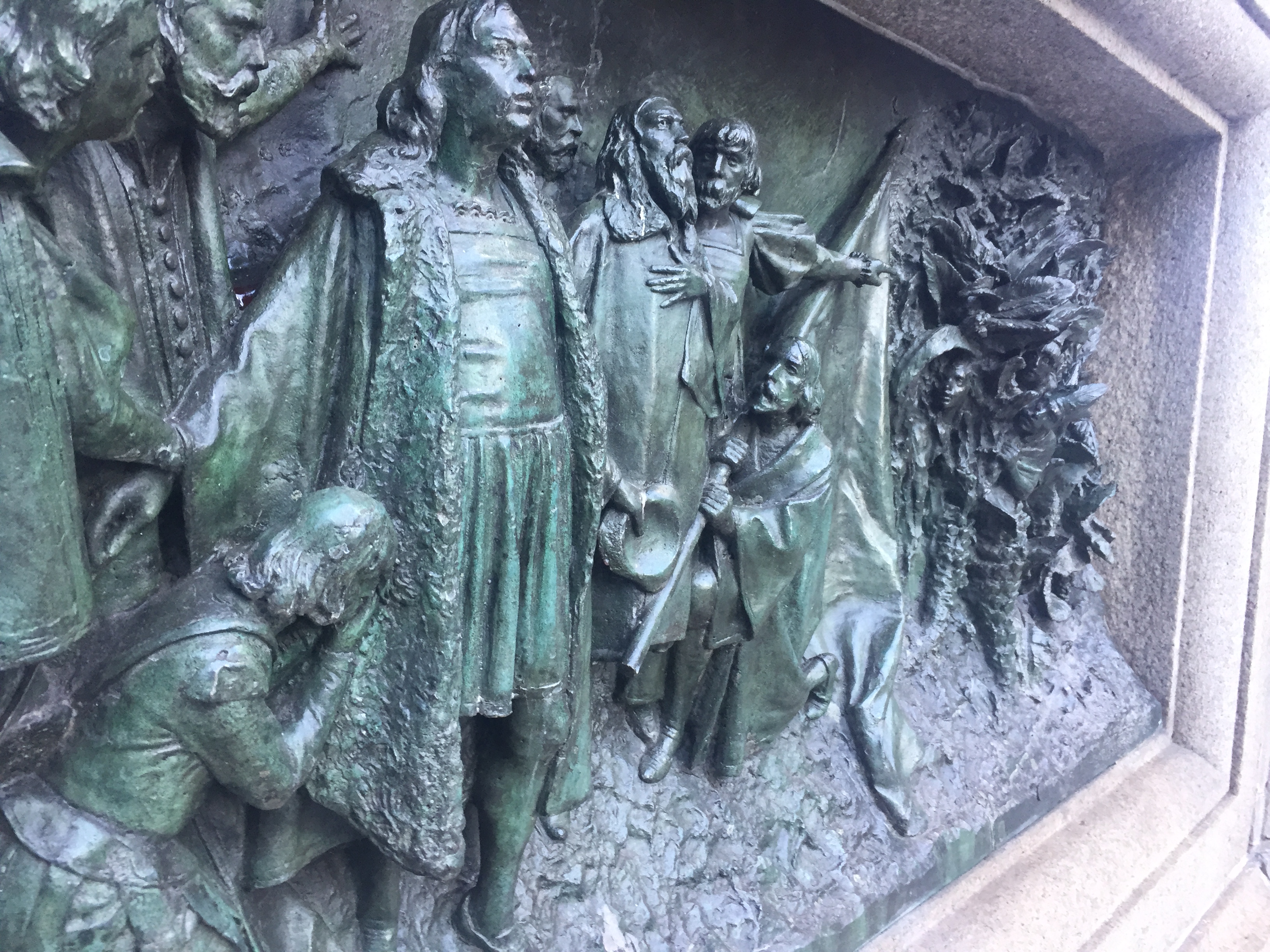
–in an iconic image of the arrival of civilization in an uncivilized land, even if his Catholic religious identity seems temporarily suppressed.
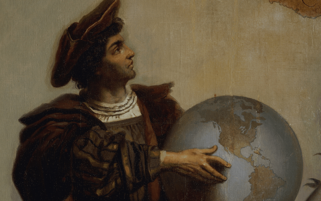
The image of Columbus as an “indicator” of the path to colonization and the New World is drenched in blood, shown as he most often is removed from any geographical context, guarding a globe close to his body in a proprietorial manner. While the iconography of Columbus often–and insistently–depicts him as detached from the world, or as the incarnation of a cartographic imaginary of control over terrestrial space, if not of possession of the space of a terrestrial sphere, armillary sphere, and dividers, and the restoration of a new era of world history–the mastery conferred by the globe seems the division and distinction between self and other, as the tools of western civilization are aligned with the sailor.

And so, the celebration of Columbus Day offers a basis to revisit the contours and celebration of that world history, and examine the question of world making that carried so much weigh, and symbolic power, even though much of the world has been far removed from white, male hands.
1. We can imagine the difficulty of processing the extent of the Atlantic Ocean in earlier times, but the very idea of “discovery”–“a dude discovered America? c’mon, like it didn’t already exist??!!?“–poses questions of privilege and race, in ways we are challenged to come to terms–or even perhaps fully admit. Questions of naming, mapping, and sovereignty, questions that are central to the debate about public statuary of Columbus–and the commemoration of Columbus Day, but already were addressed in the figuration of first contact with the New World, if in ways far more different and distinct than they were once celebrated as islands in the first accounts of the New World in De Insulis super in mari Indico repertis (1494), which revealed Columbus as the prime actor in a new nature of transatlantic exchange that echoed the very hope of the discovery of the route to the Spice Islands that had inspired Columbus’ initial transatlantic trip–even if he did not vision it as such.


For if the image of Columbus as surveying space from an empiric remove with complete equanimity was recapitulated in the quadricentennary by Italian Americans who elevated Christofoo atop a seventy foot pedestal, in New York City’s Columbus Circle, in a piece of Roman statuary created with funds raised by the Italian-American newspaper Il Progresso as an emblem of Italian American mmigrant achievement, in a statue thirteen feet tall in stature \sculpted in Rome by Gaetano Russo, as if to respond to the recently erecged Statue of Liberty; standing on terra firma, and not in the Harbor, atop a granite column adorned by bronze prows and sterns of the Niña, the Pinta, and the Santa Maria, the three caravels by which he sailed to a New World, Columbus seems to inscribe the new land for Europeans in statuary that recapitulated Eurocentric maps,an aerial view in facing south to survey New York harbor that anticipated the mapping of the New World.
But is is in fact surveying not an ocean, but stood imperiously over Broadway, before being dwarfed by the increasingly commercially congested area of Columbus Circle, now almost overwhelmed by surrounding steel and glass monumentalism, ranging from Trump International to the Time Warner Center. If Columbus is so dwarfed by modern monuments beside with the statue seems quaint, and a relic removed in time whose gaze and posture is less imperious than was first intended,
Yet the monumental detachment of the figure of Columbus from the world–and from his surroundings–a point that the Italian Americans sponsoring the monument seem intent to foreground, by elevating the figure of Columbus as a complement to the 1886 arrival of the Statue of Liberty in New York harbor, whose height of just over a hundred yards set a new standard for civic monuments, seems at the maximum potential height to be still visible from the ground, supported by the bronze anchors and ships’ prows that provided the evidence of the voyage that elevated his global status.
Yet does this remove Columbus from the drama of articulating the new map of colonial possessions in the new globe?
The problem of viewing the New World from afar was one that maps provided tools to address, but abilities of reading space on a map–let alone reading the networks of space that we readily digest from airplane route maps or Google Maps–were so foreign to being internalized that we must look beyond questions of cartographic literacy or the power of maps. The ability to frame–and indeed unite–the Atlantic in what might be called the “first” spherical age of global mapping, although the globes only circulated among quite elite audiences, was based on a new epistemology of proximity, as the frame of the map–of a scale and expanse that was previously communicated only in the nautical map,–a fairly arcane document of professional use and expert reading, not legible to most, and drafted on sheepskin or vellum, and rarely exhibited to large audiences, or able to be read by then–suddenly migrated to a new audience of readers and a new reading public who rarely read maps or used maps as tools to process terrestrial (or territorial) expanse, but credibly stake sovereign claims to possession.
2. We might do well to ask, in looking at them, what sort of work is done by images like maps, and the claims to sovereignty encoded in the islands that bore the names of sovereign but floated disembodied in a global sea in the Hunt-Lenox Globe–a small globe whose careful worksmanship suggested the power of contemplating the newly “discovered” lands.
Hunt-Lenox Globe, ca. 1510/courtesy New York Public Library
For the mapping of the New World posed the almost existential questions of situating those individual mariners who sailed the highly maneuverable crafts of caravels across the Atlantic ocean, even before the “naming” of America.
produced by Digital Scholarship Lab of University of Rochester
All of which should force more attention to the informational value of maps as transitional records, as much as the contents that they bear. Consuming, digesting, and materializing trans-Atlantic expanse was not only deeply challenging; it encouraged or taught abilities to mediate royal authority across vast oceanic waters, reframing relations of sovereign to land in ways that frontispiece to the first editions of his Letter rehearsed and sought to recapitulate by its iconography of a monarch observing from his throne indigenous peoples overseas where the three caravels arrived. The rule over these islands was, perhaps, more easy to understand or perpetuate than sovereign rule over a new continent.
But rule over a continent is rich in the modern imagination, and perhaps offers a new optic for Columbus Day. When Donald Trump, as sitting U.S. President, outright celebrated national commemoration of “the legendary achievements of an intrepid Italian explorer,” defending the federal holiday against the proposed renaming of the holiday as Indigenous People’s Day, he seemed to relish the prospect of uniting the nation around its celebration. But in citing the “daring spirit that built our great civilization” as a foundational myth celebrated from Columbus Circle in Manhattan to Columbus, Ohio, he exploited a fault line running through the nation, in fact quite divided, and was promoting the further division of the nation. The divisions are sharp among the eleven states where Indigenous People’s Day is recognized, and the “defense” of observing, as if to defend native land: by no small coincidence, the celebration of Columbus Day mirrors the “heartland” Trump professes such ties–if it is also contested in the very red states in the map that Trump may be addressing, and seems pretty clear to be lying prominently in his head.
The foundational image of observing the holiday is not only restricted to the interior–and where the pedestal of Columbus in Columbus Circle was recently declared a national monument.
The image of an “attack” on Columbus Day Commemorations has become a bit of red meat for the white electorate, fearful of a changing national map–and the growing cities and schools opting to pass or consider resolutions to question its observance, questioning bearing witness to the seizure of lands and their violent conquest. as cities across thirty-four states observe Indigenous People’s Day, a concept introduced in Berkeley, CA, on the quadricentennary of 1992.
If the commemoration of Columbus Day is described as “under attack figuratively, and increasingly, literally,” in way that reverse the figure of the invasion of the New World and new world peoples, in response to the national project in re-remembering the navigator’s first of four expeditions of enslavement, land seizure, and unleashing smallpox, measles, and influenza to a continent they had not earlier existed, killing up to 95% of indigenous populations in the Americas. If the questioning of Columbus Day is leading to its abolition in many cities–

–the geography of division has never been more pronounced than in Trump’s America, as we almost forget what was being mapped in the discovery of the New World, so fearful are many of recasting the navigator as “a rapacious pillager and a genocidal maniac,” as if this were an attack on rationality, insulting the allegedly pious motivations of conversion that had long enobled Columbus’ oceanic voyages as a mission of vandalization. At the very moment that the legality of Trump’s acts as ahead of state are questioned, insisting on the vision of Columbus as a historical figure who must be removed from ethical examination was classic Trump.
Fot the figure of Columbus as an intermediary of royal authority over a global context was the first image to preface Columbus’ legendary epistolary accounts of the New World. The tension between a throned man in the lower left hand of the frame–the Spanish monarch Ferdinand–and the naked natives in thatched grooves is linked by the intermediaries of the four sailors in one of three caravels at the shore of these islands with palms. If the woodcut suggests a division between its left and right registers, they overlap in a vision of a domesticated nature, at the base of the woodcut, extending at the foot of the enthroned monarch who dispatched the caravels, and the exoticized nature of the New World, far removed but imagined as if continuous with it, in a pictorial rendition of the continuity of the mapped globe. The most striking apsect of the frontispiece to Columbus’ letters remains the bridging of the ocean by a gesture, a representation of transatlantic communication, as if in the royal gesture could bridge the seas.
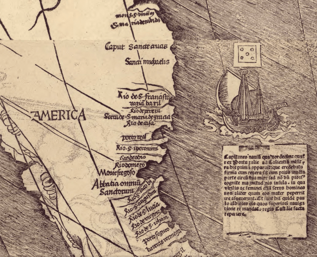
3. The discussion by Waldseemüller and Ringman in the first printed maps of the discoveries described the newly discovered region, America, as “an island, inasmuch as it is found to be surrounded on all sides by the seas,” the discovery of America by Columbus was quickly heralded as fulfilling a prophecy of empire, and indeed the mapping of discovery was taken as having evidentiary support in literary predictions of imperial expansion, as a “land beyond the stars, beyond the paths of the years and the sun,” and the concretizing of claims of discovery were figured in artistic terms, before cartographic ones, so difficult was it to assimilate the New World that lay at the imposition of a flag representing the state at such an actually unimaginable considerable spatial remove–as well as the process of naming this new land as an extension of the influence of the Portuguese crown across a previously unmeasurable space.
A cartouche off the coast of this new continent describes how the land appeared suddenly, “at this very spot to the fourteen ships that the King had sent from Portugal to Calicut,” still of “unknown size,” but whose naked inhabitants provide, implicitly, targets of conversion in a spatially separated but not necessarily removed continent, where the tools of mapping offered tools of domination, a counterpart to the routes to the Spice Islands that the Portuguese monarch had already claimed, and the spatially removed networks of trade in pepper that had enriched German merchants, and the preparation of the map has been recently understood as a reflection of the interests that German merchants had in promoting Portuguese trading interests by diminishing Spanish hopes to discover an alternate route to the Spice Islands, rather than a new continent, as much as a disinterested declaration of cartographic abilities: such formulations did not exist, in the sixteenth century, as America was already a focus of political and economic interests in a global web of commerce. But the insularity of this new “America” was well established in literary terms, and derives from De Insulis super in mari Indico repertis (1494), the first collection of Colombian letters, a powerful literary precedent.
The woodcut map was itself richly literate, and adorned by text. It could be that the map served offered an argument of spatial navigation and nautical travel. But the 1507 map was articulated a notion of sovereign authority , as much as spatial measurability or of nautical measurement. Only by the end of the century would Edward Wright, in a treatise on the errors of sailors, explain the mathematical transformation of global space in the Mercator projection that set longitude and latitude at right angles, and advocating sailors to make their own charts; the image of sailing along curved lines of longitude and latitude–intersecting at right angles on a curved surface–rather explained how a Catholic monarch in Lisbon could send ships across the ocean and transport and impose faith in the New World: Vespucci, whose education and trade Waldseemüller celebrated in his map cartouche, and whose travels on a Portuguese mission go acknowledged in the use of his name for the new continent, but whom Waldseemüller didn’t know, offered tools able to be shared in Europe that moved across networks of learning to translate Colombus’ first descriptions of a “tierra firme, grandissima, de que hasta oy no se a sabido,” into a marvel of terrestrial extent.
Marvels offered a discourse to grasp new worlds, and their possession. When the Genoese sailor Colombo passed the Orinoco, he marveled at the extent of outflow of the “great” river’s waters into the Atlantic ocean, and led him to marvel at discovering an “other world” to the Spanish Catholic monarch who was his patron, announcing fulsomely that the lands that might be possessed by the monarch outside his realms’ sovereign boundaries, marveling that the waters of “tan grande rio” might well have flowed from Paradise–as was confirmed to him by the considerable beauty of trees and animals at its delta; the marvel of the inhabitants of the land led the Venetian ambassador to Spain, Domenico Pisani, to marvel at its beautiful, naked inhabitants in 1501.

Vespucci marveled at the lands from which he had returned in 1502 as “deserving to be called a new world as knowledge of them was unknown to previous generations and about which is entirely new to those who hear about them [novum mundum appellare licet, quando apud maiores nostros nulla de ipsis fuerit habita cognitio et audientibus omnibus sit novissima res],” as a true continent more densely populated than Europe or Africa, he made a proposition of the value to colonize it.
2. The exact but simple instruments Vespucci used offered an ability to contract the considerable the spatial remove of this land, which earlier accounts seem to have left open as a question and a challenge. If the simple perspective bridged an oceanic remove, in the woodcut that prefaced Columbus’ letters, it had also invented the notion of transatlantic sovereignty, across space and sovereign borders, in the very first image that introduced Columbus’ letters from the marvels of the New World and its inhabitants, adopting a new relation to a New World.

As the set of letters bridge the New World and the Old, extending across the globe, in what we must take as a first image of globalism, they prepare the notion of the legibility of the map, able to bridge huge global distances, and the virtual continuity it frames between the Atlantic as a navigable space and a unified sovereign domain: the image of sovereignty that the frontispiece seems to celebrate, and declare, present the medium of letters as a basis to bridge space, and to perform a geographic transit across a network of sovereign rule, enacting the very claims of sovereignty that the naming of the islands perpetuates, and that the broad objections to the discourse of discovery, and the “discovery” of the Americas, presents.

