
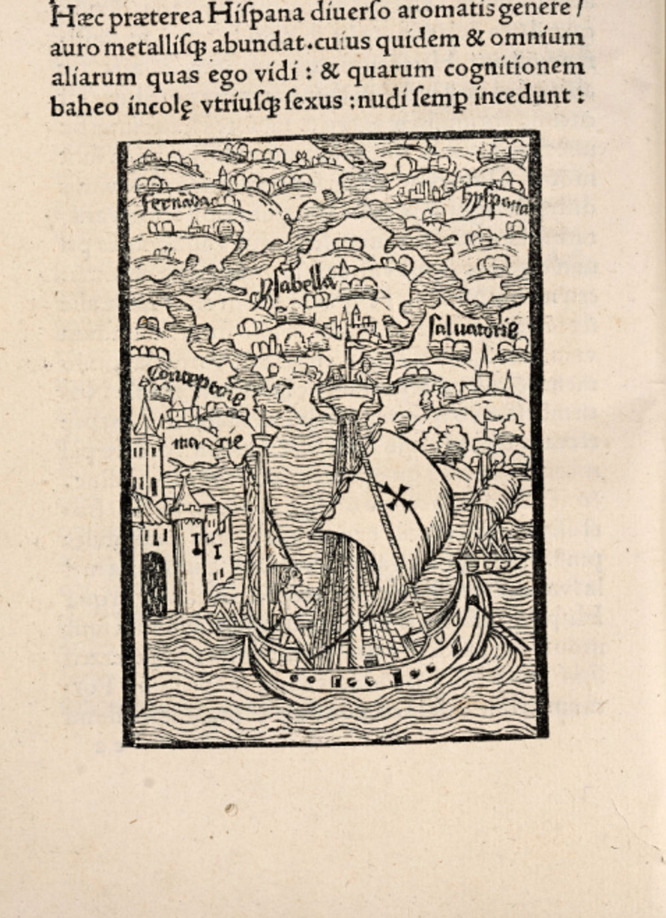
17. Cartographical renderings of the disposition of the islands at which the ship arrived appeared much as were named by Columbus in a map. Columbus enticingly described them as very different from Spain both in its smells and abundance of gold and other metals and named the islands to take possession of them, in ways it suggested that the unclothed inhabitants never had, and opened the lands to European observation in ways that, implicitly, the natives would not have access: even more, in the map the almost interlinked islands seem inhabited by castles and dwellings of their own, but are not only not known, but belong to a landscape which the Spanish sailors have assumed rule and renamed to mark as continuous to the known world–if quite different in their vegetation and in the unclothed condition of their inhabitants, as the letter repeatedly stressed and the sailors must have been impressed–in addition to the variety foods they ate, their practices of eating, their nakedness and their rudimentary dwelling sites.
1494 Basel edition, 31v (courtesy Osher Map Library/University of Southern Maine)
Although the narrative of arrival at these new lands was primarily shown in pictorial form to highlight the moment of contact–

1494 Basel edition, folio 29v; courtesy Osher Map Library/University of Southern Maine: Columbus’ Arrival
with trade at its ostensible center, trade was somewhat suspect, and only the immediate focus of attention and curiosity.

Osher Map Library
For the deeper possibilities and filters through which the contact with these islands was seen, heightened by the context of reading Columbus’ purported letter in the context of the papal humanist Verardus’ rather triumphal history of the conquest of Granada with which it was published, and the dramatization of this conquest that had been performed on stage in Rome, was concretized in this landscape/map of Hispaniola and part of San Dominic (Santo Domingo) as areas ostensibly ready for its own future conversion–indeed as offering to map the possibilities of conversion that their discovery portended for a universal victory of Christianity in the now-amplified inhabited world, rather than a re-mapping of the ecumene. The quasi-divine nature that Columbus arrogated to himself, confirmed by the ostensible numerous signs received in his mission’s progress across oceans–“By many signal miracles God has shown Himself on the voyage,” he wrote in his journal on May 1, 1493–confirmed that although he claimed to wish to discover the entire coast of the newly found lands, to “give the story of them to Your Highnesses,” the story of conversion loomed particularly large, if not centrally, to his suspicions of a far more expansive “mainland to the west.”
So did the potential profit of the island’s rule, and the administration of its evocatively described gold mines.

The sense of a network of in which to process the discoveries is also evident in the presentation of the discoveries in the gores that allowed the construction of the unique form of globe-shaped maps that have been suggestively found to have emerged with perhaps more widespread nature than had been earlier thought soon after 1500. The “description tam in solido quam in plano [illustration as much in solid form as on a flat surface]” seems to have provided a convincing way to represent the practice of discovery–and indeed the matrix or network of the discoveries–for a large audience, in ways that different both from the nautical map in its organization of space as a network that could be read.

18. The complex proposal of an “America noviter reperta” across oceanic expanse, as much as terrestrial space appeals to the harmony of a grid-like representation to reduce terrestrial expanse as an indexical network, as well as to concretize the globe. The image is often assumed to be that of the humanist Martin Waldseemüller’s Cosmographia Introductio (1507), which continued through the first two decades of the sixteenth century as a way to stabilize speculations about the New World. The gores seem to have been intended to reproduce a readily comprehensible image of global relations on a network of spherical form, as the apparent assembly instructions of this flysheet, recently discovered in Munich–
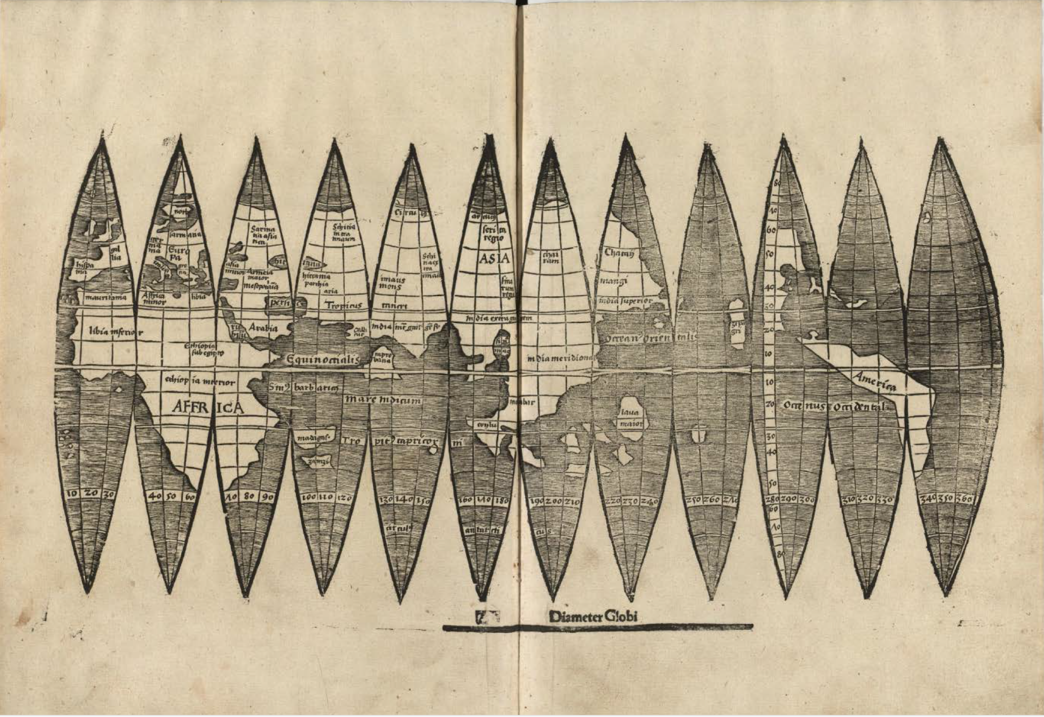
–and which would probably have resulted in the creation of a more detailed and far more legible reproduction, something like the below reconstruction, which seems particularly suggestive of the perils of trans-oceanic travels, but takes pain to confirm the fundamental indelibility of the network of space that embraced a churning oceanic expanse.
What better form that a globe could describe, in other words, the islands first described for European audiences in De Insulis super in mari Indico repertis (1494)?
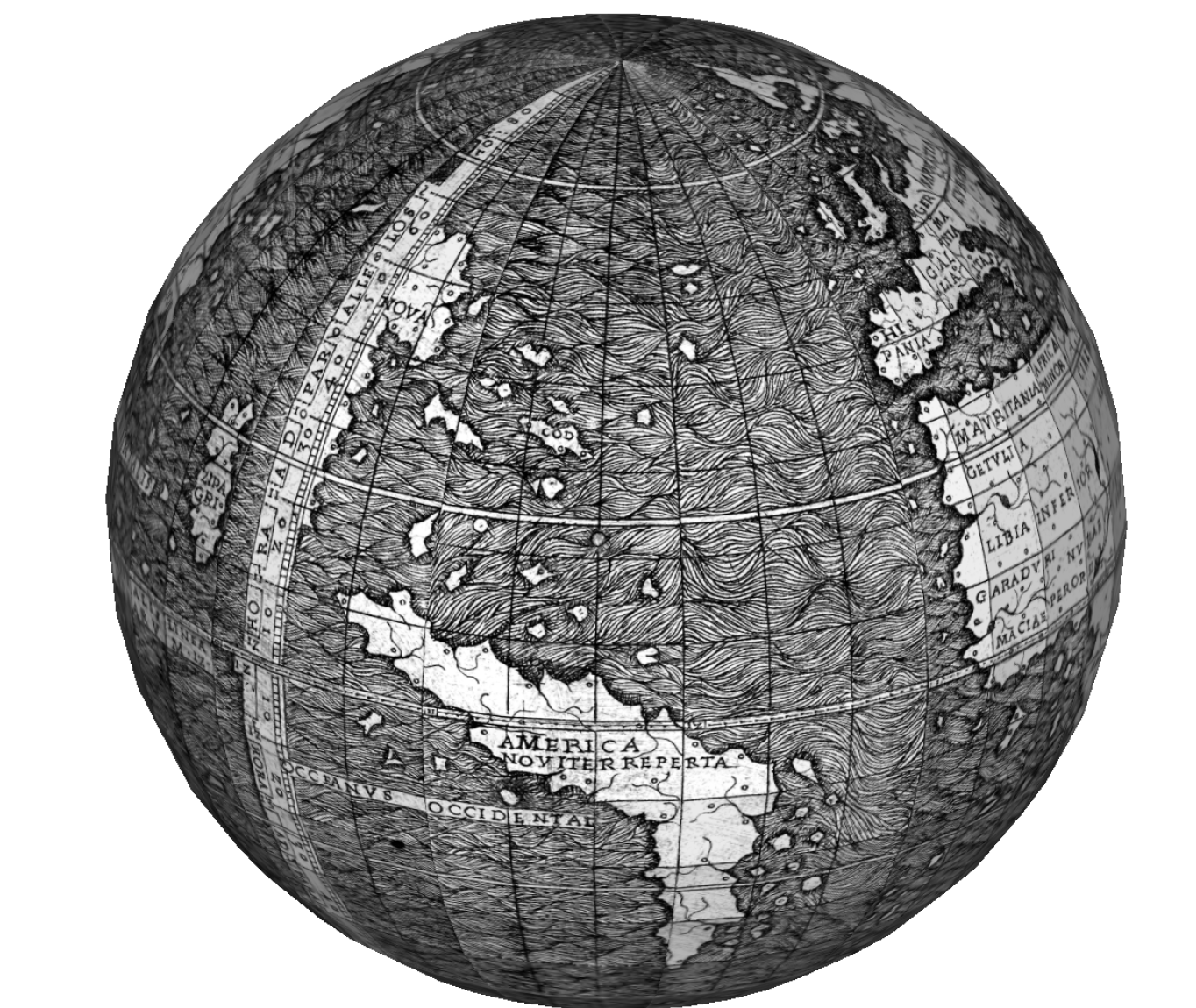
1507 edition of the Cosmographiae Intruductio edited by Louis Boulengier, adapted from Waldseemüller (adapted as a globe by Georg Zotti)
19. The suggestion of a plenitude of such manually spinnable globes–try your hand at the game of spinning early modern globes and the apparent mastery of global networks that their rotation offers–suggests the appeal of comprehending the mastery of an interconnected network of space, often comprehending and noting the courses of recent ships and including the maritime conveyances of ships themselves. The way that such a network established a frame of reference to describe and indeed reproduce a stable discourse about reports of the New World demands to be studied as a network of meaning, as much as one of discovery; the relationships that it suggested became ways of rendering visible a variety of networks, as much as for comprehending spatial immensity, as it provided a surface with which readers could meaningfully interact.
20. The site of performance of reading maps became a basis and excuse for their reproduction, as much as the systematization of meaning. Although the humanist Waldseemüller has been credited with the innovative assembly of a globe that indicates America as a site readily localized on a world map’s surface, the ability for locating its place seems perhaps not only more widely diffused, but a more concerted effort of a corpus of widely printed cartographical depictions.

