
Our way of moving through space determine the nature of our maps, and in a globalized world, it is both focussing and challenging to think about old ways of occupying and moving through or across space. This map by a Venetian (Istrian) admiral who designed nautical charts, Pietro Coppo, incorporated the popular genre of “island books” to suggest the infinite number of places that one could visit by ship on the edges of the world–and the unknown continent of the Americas peek out from one edge–and the range of Mediterranean and west African ports to be reached by sea.

The nautical chart reveals a sense of the motion across waters to new lands, but I want to focus on how railway maps reveal the accessibility of space because they suggest a world we have lost in which the accessibility of space and routes of travel are rendered like a public good, even if for commercial ends.
Railways defined, in ways that highways later came to do, a new sense of national space like “the Highway of Nations,” because they graphically charted–much in the manner that this 1869 map of the transcontinental line from New York to San Francisco, a new way of moving through space.
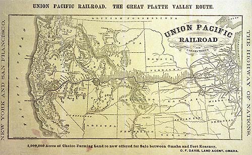
The single thread of a line that reaches across the continent, names of stops stacked perpendicularly to its course, much as the names of ports in the nautical chart, the railroad’s path provides a metric by which terrestrial expanse was traversed.
The map charts a model for moving across an almost unknown expanse for rail-travelers, past an area defined only by a loosely understood hydrographic web. It was, to be sure, replaced by the highway maps that provide individualized modes of transcontinental travel focussed on one destination.

Almost a hundred years after the engraving of the Union Pacific Railroad as a network that linked the nation, and just before the issuance of the infamous 1961 “Beeching Report” addressed “The Reshaping of British Railways” by setting out to prune the branch and secondary lines that received limited traffic in Britain’s national rail system, there existed a network of timetabled traffic linked an astounding number of cities and towns to provide access across the nation’s expanse:

The cartographer’s pride of this map seems evident and on display, and it depicts an extent of lain railroad track unthinkable in the infrastructure of the twenty-first century. Take, for example, the detail of the network of communications created between Aberdeen, Edinburgh, and Glasgow, before decimation by the folks who tried to tabulate the economics of rail use in terms of passenger-use per ride:

If Coppo’s world map offers a somewhat quaint rendering of the Americas that peek into one edge of a cosmos reminiscent of a medieval view of infinite islands ringing an habitable world, the railway map is a map of spatial access for all as remote, in those days before the denationalization of transport.

