
The “Central Park Effect” describes the interrupted avian migration that annually funnels a range of species of migrating birds into the trees of Manhattan’s Central Park. As they move along the great flyways of the eastern seaboard in search of a roost, the patch of trees amidst urban canyons of inhospitable anthropogenic landscape seems an area with something like habitat, whose edges offer a target to rest on a flyway that, by the time it passes the northeast Atlantic, is nothing if not overbuilt. If the park long held the space for repose on promenades and staged wilderness, birds have made it a home, amidst the anthropogenic landscape of the eastern seaboard offering far fewer and fewer roosting places during migration, recognize the park’s arboreal density as the last place to stop on a long trip north.
For the urban resident, the interruption is idyllic: the refugee from rural New England, Frank O’Hara, drank up the urban landscape he arrived in 1951, through his death, in ways that didn’t need more greenery than the Park offered him on lunch breaks. “One need never leave the confines of New York to get all the greenery one wishes,” he wrote, in dialogue with Walt Whitman’s poem that takes its spin from Brooklyn’s Greenwood Cemetery, while allowing that the city had made him so urban “I can’t even enjoy a blade of grass unless I know there’s a subway handy.” As O’Hara exultantly catalogued the hidden space of New York’s landscape, inspired by the movie houses, Manhattan Storage & Warehouse Co., and cavernous subway, the Park’s trees were enough, but also suggested about as much of the rural that he could stomach in his urban aphrodisiac that was the city that was the “center of all beauty.”
If the early trees planted tin the carefully landscaped arboreal island was hardly bound by built space, and wasn’t really an island, but modeled after European beaux-arts parks, filled the settlements of squatters in upper Manhattan–Irish pig farmers; the African American Seneca Village; gardens German immigrants presided over–with a monumental space of curated trees, whcih a hundred years after its founding had fallen into some state of delapidation, as huge towers surrounded its walled perimeter.
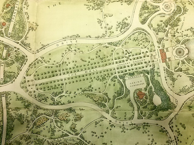
Few thought to catalogue the trees that now populate New York’s Central Park, the tide has turned. Back in the mid-nineteenth century, the expansive 1859 fold-out Visitor’s Pocket Guide to the park’s principle ponds, opened a prospective on the newly wooded regions of the park, taking time to caution visitors from disturbing the picking of any berries or flowers, as if it were a site of nature, lest they disturb any “construction, tree, bush, rock or stone.” Its trees appear carefully situated in rows, and planted beside promenades, in stark contrast to the arboreal density today. The expansive seven-sheet fold-out map was probably based on the original pen and ink design drafted by Olmsted and Vaux as a proposal for an open, recreational space in the city, the Greensward Plan, with many paths not yet constructed and others eliminated by the time it opened in 1857, as a truly bucolic space for strolling, rather than the wooded enclave that the park has since become. The product of human work of construction of some 5,000 laborers–a miniature army responsible for paving, bench-making, constructing tunnels and bridges, lighted electric lampposts, and wiring, as much as planting trees, the luxury of the park displaced the squatters’ shacks that filled the region between Fifth and Eight Avenues, bound by 59th and 106th Street per the City Council’s mandate. But trees were hardly the planners’ main intent in imagining what they called a democratic greenspace, a curated wilderness that might substitute for the dilapidated sites for squatting of the unhoused on the then-margins of urban life: the promise of a “life in the woods” was built just three years after Henry David Thoreau had waxed as a tranquil remove from urban life in Walden (1854) would have been realized in curated fashion as a sense of “wildness,” if not of lake-like reservoirs, that urban residents fortunate enough to live near to could retreat.
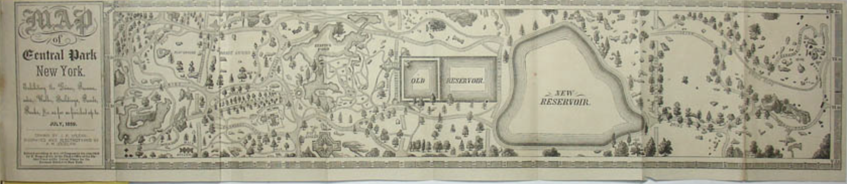
Map of Central Park New York. Exhibiting the Drives, Promenades, Walks, Buildings, Ponds, Rocks &c. as far as finished up to July, 1859 Courtesy George Glazer Gallery
The process of the planning and planting of trees proceeded by the time of the detailed lithography that Lewis Prang seems to have copied it in a form–“thin paper to fold, heavy paper to frame”–he hoped to distribute among realtors of surrounding lots, revealing a park whose “every tree and bush, as well as every arch, roadway, and walk has been placed where it is for a purpose,” as Olmstead boasted, a space urban residents might wander removed from its grid, as if to find pastoral respite from the density of urban lives. The German-American engraver Lewis Prang who desired the work, who began a chromolithography practice after emigrating, later finding notable success in chromolithographs of maps of Civil War battlegrounds, including maps able to be interactively annotated by blue and red pencil to trace the progress of armies, completed this “picturesque guide through the whole Park” in June, 1865, as what must have been a celebration of peace-time, printing it in full color only some weeks after Civil War hostilities had ceased.
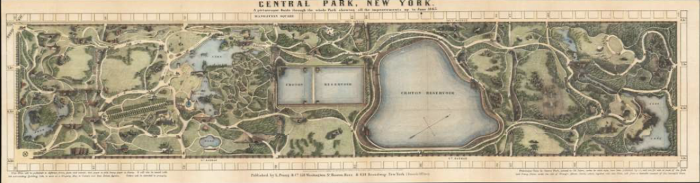
Central Park, New York. A Picturesque Guide through the Whole Park, showing all the improvements up to June, 1865
How to call attention to the variety of trees that have come to populate that unpredictable planned green space of Central Park, to catalogue its rebuilt pastoral? If the park was long seen as a site of danger in my youth, long a nocturnal site of cruising and unplanned encounters, the park planned around the Central Park is lauded for modeling the abundance of urban nature as if in negative to the built space of surrounding skyscrapers that roost around its edges.
The way we map the park on the subway, indeed, suggests it is somehow magnified as a needed refuge for those to remember as they are coursing in cars that rumble on tunnels underground, far from any sense of open green: if the park is magnified in the famous transit map to afford a greater legibility of the tangled web of midtown lines that twist like branches or snake like roots of the circulating urban collective, it is important to remember that its lakes exist, even if its trails need hardly be mapped for audiences orienting themselves to public transit routes. We map the park, whose green provides a pause and respite from the grey concrete facades of buildings, as well as a site for strolling, by a flat lime-green interruption of the urban grid in our public maps, as if the park was an abrupt interruption of the tan city blocks, cool blue ponds creating a shared space of reflection in a landscape dominated by private property and expensive residences. And there is a sense of lack, perhaps, or wanting, that the cartographic silences of that pea-green space open, like a yawning opening traversed by busses along curved horizontal line, set apart from the urban grid.
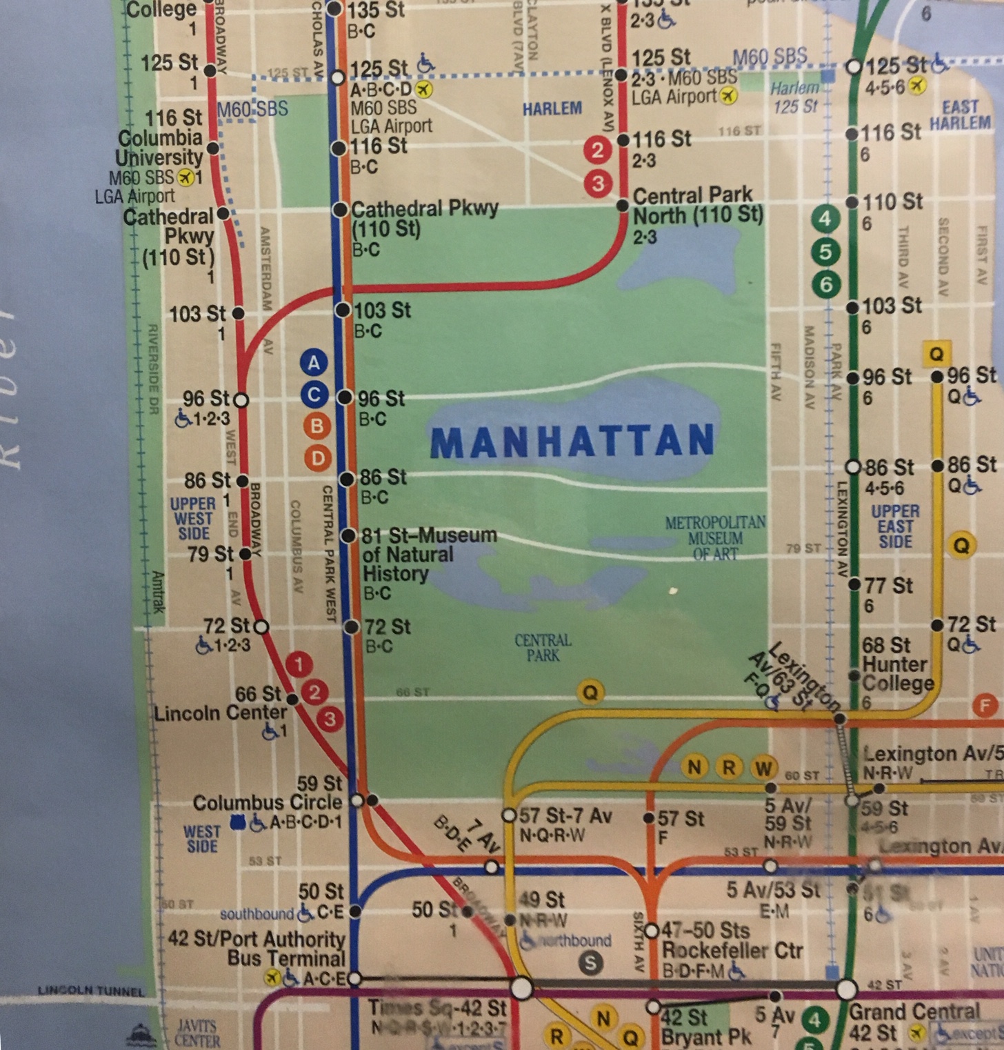
The subway map affirms, in a weird remove from the rider who is traveling underground, a removed oasis of sorts, ringed by a tan frame of muted buildings–as if a place to experience wilderness, or a curated sort of wildness.
Created in the parks movement that redesigned urban space removed from unsavory elements and moral lassitude, and restored as a reprieve from the pace of urban life, the rebirth of the parks as open green-space has recently occasioned the first complete census of individual trees, those often uncounted inhabitants of Manhattan island. And each tree has been mapped, in recent years, to allow one to voyage through the space of planned trees, migrants, and recent arrivals of conifers and other volunteers, joining the staid oaks, elm, and London Plane tree.
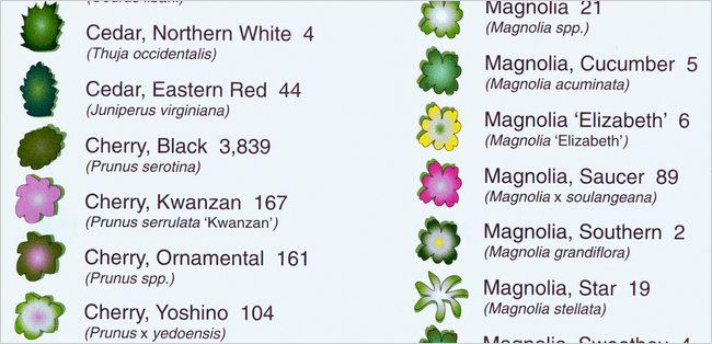
The trees have been counted in Central Park, unpacking this light green space in an enumeration or ‘green census’ cartographers Ken Chaya and Edward Sibley Barnard created. The result is a deeply ethical way of directing our attention to urban space, in a comprehensive map of the tree space often rendered as a stretch of undifferentiated lime green. Indeed, the counting of large-trunked oaks, maples, individual pines, and sturdy sycamores in all their varieties offers a detailed abundance that is rarely evident in the parks maps that adopt a single cool shade of idyllic green, and offer a sort of palimpsest that will reward map-readers to pause over, examine, and explore–and indeed pore over, with the botanical level of detail and connoisseurship that the earliest planners of the park might well have appreciated and enjoyed–if not expected of city-dwellers.
Who wouldn’t have expected as much from urban sophisticates?
Map of Central Park: printed for the Department of Public Parks, 1873 (detail)
Yet today, the often-internalized map of the park of light green, far more familiar to all city-dwellers, may risk perpetuating an alienation from its dynamic urban forest, and obscuring the careful level of its botanical detail, or the accumulated palimpsest of urban habitats of its biodiversity. The vivid light green of most maps of Central Park may be muted, but seem rendered almost life-like in the rain–even if green is a generic “greenspace” it is one to be valued, and walked around on its circuitous paths, a space that is a distinct interruption of the equirectangular grid of the built city, and a respite from its straight lines and sheer heights. One can see not urban canyons, but the sky.
In part, the duality of Central Park as rural and urban captures the hybrid identity as an urban park. Even though the park seems to lie somewhat incongruously at the very center of Manhattan, as if the apparent preserve of trees and urban wildlife is defined by its porous relation to the urbanized setting of the park. If Central Park was designed in the movement of urban greening and public space, as a site of health and interruption of urban life, the park is increasingly more of a heterotypic combination of urban activity, designed built spaces, and manicured wooded areas, a refuge where Manhattan is in a sense perpetually present, not only bur urban sounds, traffic, and lifestyles, in a dyadic relationship that seems captured by the fact that it offers not only the sole open space to inscribe the toponym of the island in subway maps.
In such maps of urban transit, it may be that Central Park acts less as a park, than it serves as a totem of urban space; the park holds the bold-faced word “MANHATTAN” that identifies the city, its flat green spaces and clear light blue lakes crossed by ribbons of white roads, indicating its nicely settled position as secure in an urban grid, as if fastened by crosstown routes, yet readily available to urbanites at multiple entrances as a site of repose. The image of the interruption of urban space we encounter on subway cars with regularity reminds us of the existence of open green space which we can access, even while we ride in eardrum shattering rumbles of subway cars coursing on old tracks while winding one’s way downtown to one’s destination. Is it an important reassuring reminder of the existence of open spaces that are in fact accessible, even while we may not feel it, nearby?
The combination of nature and skyscrapers was a unitary construction, several ecopoets have observed, a conundrum or urban nature explored by ecopoets who take up the gauntlet that the urban spaces throw down. When the poet Gary Snyder described his arrival in New York City, he evoked an ecosystem blending nature and culture that began form its trees and moved settle throughout the island’s sidewalks, streets and skyscrapers, even as it clung to the edges of its shores.
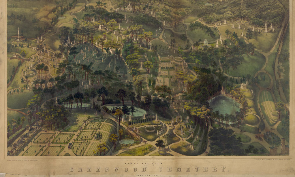
If the winding paths of the park were built as a space of democracy, modeled after the popular Garden Cemetery Movement of such exemplary success in the creation of Greenwood Cemetery as a preeminent public space of trees, winding roads, lakes, and monumental graves in Brooklyn–the trees and wooded regions central to its appeal.
The sense of the showcasing the green space of the park had declined considerably, of course, by the 1980s, when Gary Snyder admired by the crowded built environment of New York as an ecosystem–or rather as a “deep ecology”–in “Walking the New York Bedrock,” careful attending to the juxtaposition of its trees in the steel skyscrapers of its overbuilt financial hub. The ecosystem was vibrant, but removed from wildness, if oddly emulating it in its crowded urban density upon its paved grid and steel and glass towers; helicopters like insects “trading pollen,” above skyscrapers competing for photosynthetic abilities, sirens coursing through its valleys and paths of subways like lichen rooted underfund. Snyder sung the collective recreation of a lived connection to living landscapes, the Central Park Conservancy was in its early years. The dolomite and schist that provide the basis for the actual “bedrock”–the basis for the rich growth of foliage across the island, and support offered its ecosystem–resting atop a thick bedrock of metamorphic Hudson Schist, marble, and dolomite.
Snyder has meditated on the human relation to the built as a retraction from the wild in The Practice of the Wild (1990), which flippantly denies the vital sense of the wild in human life. Snyder wrote about the built the connection to the lived landscape that Snyder located in its wildness that remains in many natural environments was increasingly restored and retained in New York, where, as Snyder noted “there is nothing unnatural about New York City, or toxic wastes, or atomic energy…,” the trees which introduced and whose presence punctuate the poem were foregrounded in Central Park in the very years that Snyder wrote and following decades. The Conservancy has done much to call attention to the range of foliage of 20,000 trees whose foliage–Red Maple; Hickory; Sugar Maple; Scarlet Oak; Red Oak; Dogwood; Star Magnolia;–it keyed with classificatory precision–
–to bring the space into crisper detail for us, and to attract us into its surrogate of the greater wild.
An abbreviated catalogue of a parade of urban trees–“”Maple, oak, polar, gingko/New Leaves, “new green” on a rock ledge“–are the starting points for Snyder’s urban walk on the. bedrock in Walking the New York City Bedrock (1987) that capture their dissonance with the “gridlock of structures,/ Vibrating with helicopters,” in an ecosystem populated by businessmen or by “Cadres of educated youth in chic costume,” coursing in the subways and paved surfaces under which run subways, the lichen or spiderwebs of the urban ecosystem. But the restoration of the wild within the built environment of the city are celebrated in the recent atlas of the parks trees. For they have been allowed to congregate as an interruption of the built environment, but also as an ecosystem in it.
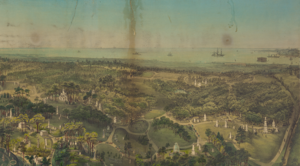
The “park” was long promoted as the primary shared green space in the city–and a space where city-dwellers retreat, at times, to smoke some green stuff in a meadow or on a hill, the definition of the park as a set of individual trees has rarely been mapped in detail, examining the arboreal space that inheres within this interruption of the built environment–if only to excavate and explore its complex past. For Central Park was built as a site of public promenades, a planned space akin to the popularity of the mid-nineteenth century Garden Cemetery movement that had led to the landscaping of urban areas as tranquil grounds of rest, designed within the city as sites of visitation and at a contrast from its commerce.
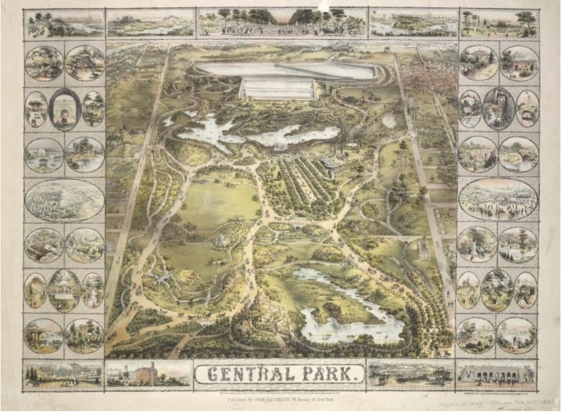
Walt Whitman, when a newspaperman, often entertained readers by the pleasures of knolls, rivers, and trees in faux rural Greenwood Cemetery that provided the illustration of Garden Cemetery in New York City by 1854, whose paths provided a sense of prospect over the harbor and winding paths, lakes, and hills among its monuments, that he inimitably exhorted all to visit, a combination of cultivated plants and open space John Bachmann crafted a perspective view in a tinted lithograph, inviting viewers to survey its planted trees and cultivated plants, as well as plains of grass and planted fields–
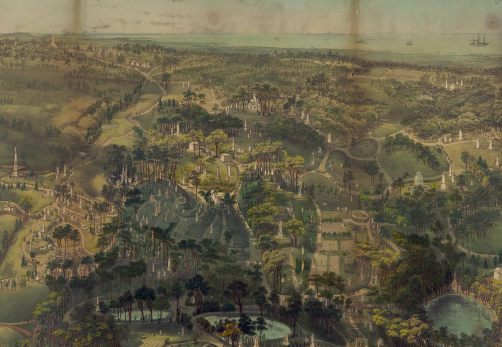
Library of Congress
–that encouraged the viewer to detect the cultivated scenery of trees and plants as if to recall the praise of Virgil’s ancient Georgics to agricultural cultivation of a bucolic preserve where “in the woods the almond/Lavishly blooms so that her boughs bend low,/Fragrant with blossom,” beside where “the crops will be/Lavishly rich as well, with the great heat/Of the great exultant threshing following on.” Amidst trees burgeoning with leaves, “and therefore over-copiously shady,” the park as the cemetery would offer a place of rest, as much as work, where “Among the cultivated plants/Darnel and tares and sterile oat-grass thrive,” the overgrowth cut back with pruning knife to nurture and reveal a well-tended oak tree, juniper, cypress, spruce, willow, Linden, beech, almond, following proper precepts of cultivation to reap the benefits of sewn seeds in the properly tended imperial landscape.
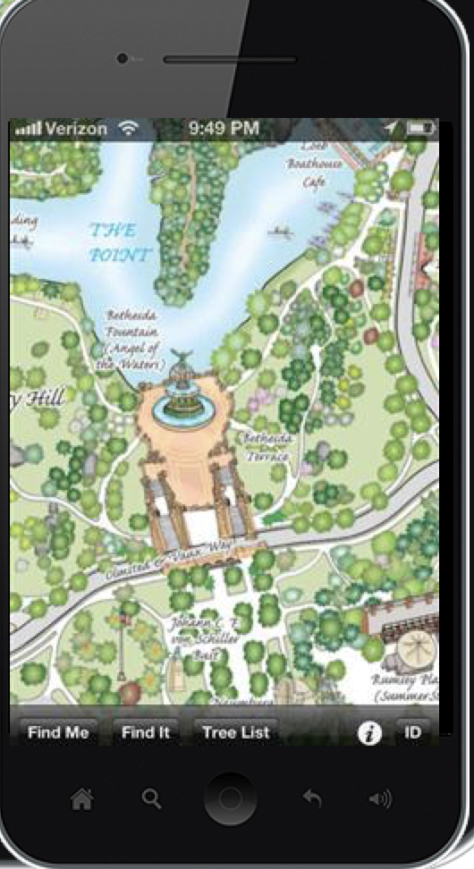
If Virgil’s paeon to the benefits of agricultural labors of planting, binding, threshing, plowing, and tending are recapitulated in the precepts of harvesting and care for the land to present a rich visual landscape in which the reader is immersed to enjoy its benefits, the range of trees, both planted and arriving by chance, have since created a landscape to be decoded by the map of each tree that the park currently contained. Drawn by hand in laborious attention to each detail, but now available as an app for easy assistance in navigating the park, the green monochrome of many maps springs to life in lists and individual detail, so that one is able to pan and zoom close-up on trees while one is navigating it.
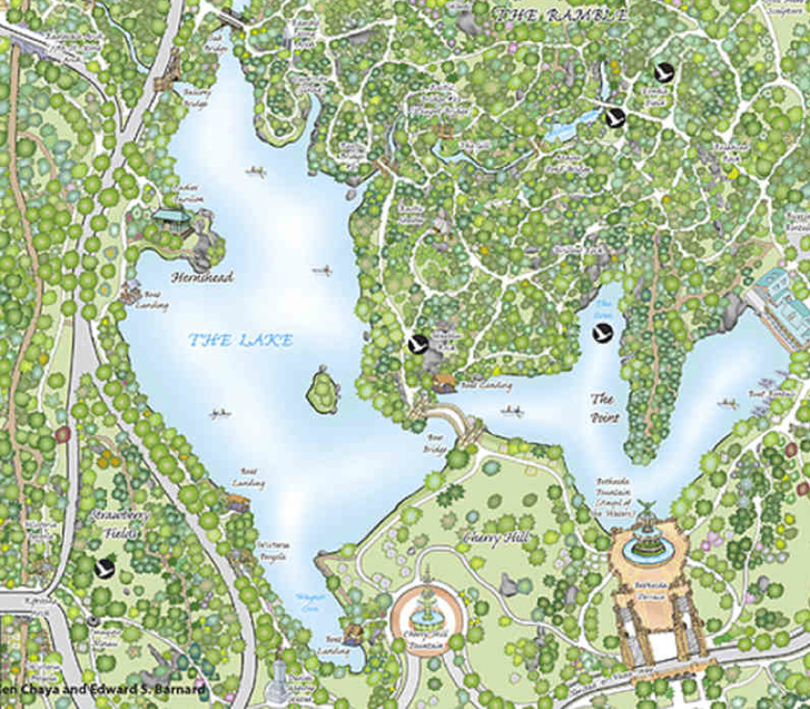
The range of trees that now fill Central Park have been mapped by Ken Chaya and Edward Sibley Barnard in Central Park Entire, a detailed poetic catalogue that itself presses thresholds of cartographic creativity, individuating tangled ecosystems of planted trees, forested areas, native plants, evergreens and new arrivals that are mixed within its landscape, moving easily to a “tree list” that provides an easy way of orienting oneself to the multiple species inhabiting Central Park, allowing users to scroll, pinch, and zoom into individual regions and, when geolocation is enabled, to be oriented to wherever you are. Users can find the names of each of the 20,000 trees in the Park, based on Ken Chaya’s two years of surveying each tree in the park’s hundred and seventy arboreal species.
Even if the landscape was built on granite and was defined by concrete and brick, the trees defined its space, however paradoxically, in ways that capture the serendipitous presence of the arboreal variety in the city “Maple, oak, poplar, gingko,” ecopoet Gary Snyder mapped New York’s trees in syllabic feet, “New leaves, “new green” on a rock ledge,” taking the arboreal collage on Manhattan’s bedrock as a metaphorical ecosystem, an artificial reef of the human scheme of the “Sea of Information” filled with streams of “keen-eyed people,” “cadres of educated youth,” howling sirens, and squirrels, that peregrines sail above, whose gridlock opens like a sea anemone of which wind sends a shudder that “shakes the limbs on the/planted trees” beside “Glass, aluminum, aggregate gravel,/Iron. Stainless steel.”
The poetics of these long lists of urban inhabitants survey an ecosystem in a new form of rhapsodic evocation of their heterogeneous admixture of natural and artificial between paved concrete urban spaces. If Virgil praised farmers, Snyder celebrates the varieties of urban trees and pavement encountered in “Walking the New York Bedrock in the Sea of Information” (1987)–an island whose gods are capitalists, where the lavish overgrowth of plate glass windows shine beside the gleams of white birch leaves, a built and natural congeries where culture and nature overlap.
A modern Whitman, Snyder embraced walled urban canyon walked by curb and traffic light, counting trees among built space seamlessly, from ginkgo trees of Gondwanaland or built bodies to the pictographs and petroglyphs of subways, beside cable and pipe, erasing any distinction of natural and artificial, as “beautiful buildings we float in, we feed in,/Foam, steel, and gray/Alive, in the Sea of Information.” Snyder’s metaphorical recasting of the urban ecology is an ecstatic wilderness, underpinned by a tabulation of trees that echoes, in contrast of the natural and the built city how Herman Melville described the city in mid-century exultantly as “belted round by wharves as Indian isles by coral reefs,” but naturalized the built walled canyons where sirens echo streets as a built landscape where urban trees and wildlife abound.
The discrete trees of the rusticated interval of Central Park that interrupts the cityscape of New York City is rarely counted, but the attention that is suggested in the list of trees offer a sense of Snyder’s skill as a naturalist, and the surprising application of an arboreal register of variety in an urban environment. For Snyder explores the city by seamlessly blending of nature and culture in New York City in ways that never stops to entertain, in a metaphorical map blurring canyons of skyscrapers, plate glass, and electric lights buzzing in an ecosystem driven by big finance that might be submarine. Amidst streams of subways, cars, taxis, rolling carts, people and birds, trees peak out prominently. While each and every tree is inscribed with a detail that might be dwarfed by the old, hulking trunks that serve as hide-outs with dark passages in the Tisch Children’s Zoo–a reminder of the forest before the park–the Park is a hotspot and mirror of the built park.
The public maps posted in the park invite exploration of its paths note its paths in a paler green beside white roads, snaking around its uniform field, Barnard and Chaya open those Kelly green spaces to the delectation of wanderers who it invites to explore the park’s arboreal variety.

As ever the eloquent naturalist, Snyder poetically turns to how trees resiliently populate the city’s built environment. He traces an environment partly forest, but hybrid, neither natural or artificial. In a cartographical compliment to his poem, or a modern Georgics of the park, Edward Sibley Barnard and his accomplice in crime Ken Chaya open up a richly bucolic vision of vegetal copia across what is the densest site of urban trees in Central Park Entire (2011).
The map provides a complete account and comprehensive tabulation of tree varieties within the city’s Central Park, the serves to celebrate the variety of trees that this special spot in the city preserves, counting the over 19, 630 trees within Central Park that will stand as a modern monument for years–until someone again tries to undertake the counting all over again–presenting it for the visual delectation of viewers in a durable fold-out paper map.

The detailed catalogue of trees and plants in New York’s Central Park displays virtuosity in evoking the variety, range, and density of trees in the city’s largest green space, rendering in detail an ecosystem often vaguely mapped, often suggested as a green space amidst built environment. In the heart of the city lies the park. Its odd combination of nature and culture is central to most city maps. When you look at most public maps of New York City that grace public transit, tourist kiosks, or other venues of spatial orientation, the area of Central Park is a monolithic green, less rooted in a survey or in a source of public data, but a light green box, set apart form the city’s streets–a block of green space located framed by the overbuilt grey of residences that crowd Manhattan island since the mid-nineteenth century, and landscaped from 1858.
A recent survey of individual trees lovingly unpacks the park’s canopy. The map serves as a guide to the arboreal population, naturalizing the blurring of nature and culture in the planted trees and volunteers that fill the landscapes of Central Park to catalogue its biodiversity, from the great American elms that line the Mall, planted in 1870, to the tuliptrees or elms. Bound by walls, the map of all the trees in Central Park recently published in Central Park Entire (2011) seems to provide something like a time capsule of the arboreal density of the over 115,000 trees in the green space of 843 square meters, as if discovering a camera of curiosity in the dense vegetative habitat of a hyper urbanized city. The emblem of the Parks & Recreation Department in New York, while a leaf, is not strictly representation, but if wrongly seen as a version of the flag of Canada–but is emblematic not of the maple, but the most common sycamore of New York:

The Parks Leaf/New York Dept. Parks & Recreation
The image offers a native design of the very trees that were chosen to distinguish New York’s urban space from the Robert Moses era. The emblematic leaf seems modeled after a London Plane tree leaf or Sycamore in the Moses era–most likely because the tree was viewed as the most resistant to pollution!–after Moses selected the tree as most suitable to the city and to widespread planting. But it the image that became a symbol of green space in the city, its new bright green shade recalling the break in built space, is not clearly modeled after any specific species, in somewhat felicitous ways, and has being alternatively if incorrectly identified as being either a sycamore or Norse maple. The hybrid nature of the somewhat stylized leaf was the creation of a graphic artist, rather than a naturalist, and its smoothed edges bears the traces of graphic arts fit for a city where a range of leaves almost interchangeably appear to interrupt built space.
The recognizable Parks leaf logo was suggested to be a Platonic ideal of urban tree suited to marking some 1700 parks, playgrounds, and areas of outdoor recreation, but it poses the question of how to map the many urban trees that fill urban space, posing the problem in its streamlining or meshing of arboreal imagery about the actual distribution of trees only recently resolved. As if the conundrum of Snyder’s own list of city trees were synthesized in one image, the map offers an admirable poring over of the park landscape that remains the most varied in the city as a whole, making the visual variety of trees able to be studied at close hand, in order to illustrate the variety of the abundance of trees that constitute something like an ideal microcosm of the melting pot of New York, if in a largely unbuilt range of greenspace.

Snyder describes New York as something of a perpetuum mobile moved by wind that “shakes the limbs on the planted/ trees growing new green” beside the “gridlock of structures” of soaring buildings and socially stratified condominiums, unfolding “New York like a sea anemone/ wide and waving in the Sea of Economy,” where trees are attached to its living mobile surface.
To drill down into the range of trees that cluster on the bedrock of Central Park, Ed Barnard and Ken Chaya focus a snapshot of the Park’s arboreal population in Central Park Entire (2011). The result is an elegant cataloguing of individual trees by isolating each and every tree that settled in this region–whose variety is so often obscured as a matte sea of green. Indeed, in the maps that orient visitors to New York City often mask the complex ecosystem that developed in the park hemmed in by skyscrapers, as if it were a drive-through space–

rather than emphasize the porous nature of its boundaries of buildings and rushing traffic that courses noisily beneath traffic lights along storied city blocks, the new map reveals an intense attention to arboreal detail and variety never compiled.
The attention to its arboreal detail is supported and in a sense animated by the Central Park Conservancy, dedicated to preserving the park’s landscape, cares for the vestiges of the natural that are carefully curated in the park, which it treats as something close to the cultural patrimony of the city, on a level parallel to the works of art in the museums that flank its green space from the Metropolitan Museum of Art to the Guggenheim to the Museum of Natural History. By embracing the combination of old planted trees and more recent arrivals, or volunteers, the map charts the rich contents of a green space that attracts some 3.5 million visitors annually, focussing attention on each of its plants, even as most maps of the city treat it as a block of green that the underground rivers of transportation of subway routes coast beside.

The wealth of the trees in the Park accreted over time, as the park provides something of a fragment of the green that once covered Manhattan island–although, as Barnard and Chaya show, a hybrid space whose trees come now from a wide range of nearby regions and unexpected vectors. The green of the island is however lost, and the concentration of green space in the park is definitely the prime reason for each tree’s increased value. In a 1865 topographical map detailing the entire island–created just years before the park was completed, as it was planned–whose generous expansive shades of rich green–arboreal density reaches across the island from its shores, stretching along the meander of creeks, if concentrated on its coastal perimeter–

–the density of trees are almost obsessively catalogued as rare treasures of nature in the map of the historical aggregation of tree cover that defines today’s Central Park.
The expansion of the park, and its values, reflects in some sense the de-greening of Manhattan over the centuries. For the confining of the arboreal in current maps of Manhattan that is the result of a new economy of greenspace after a century and a half of real estate development, asphalt, and concrete and the density of the expansion of urban real estate along its streets: the current map is a space which blends nature and culture, but where nature is rare and green space diminished, each and every tree commands valuation as a scarce resource.
\The isolated open green space in the midst of a hyper-urbanized island documents the radical recession of where green once lay in mid-seventeenth Dutch maps of the region, which colors green the island beside the Noort (Hudson) River and gives surprising primacy of place to Staten Eylant (Staten Island) in “Manatus,” coloring the region of present-day Manhattan as a somewhat surprisingly mountainous terrain–
 Johannes Vingboons, Manatus gelegen op de Noot Rivier (1639) Library of Congress
When the German graphic artist Herrman Bollmann blended the German tradition of bird’s eye city views in a 1964 3-D picture map of midtown Manhattan, he seems to celebrate the built environment of New York for the World’s Fair, showing towering skyscrapers rising from the blocks of midtown Manhattan that are juxtaposed against trees clustered in Central Park, a manicured oasis in a built environment that jumps out from the page, each labeled, as if disembodied against a grid of white streets, crowded with generic if almost identical trees. Bollmann’s project is generic–the trees are shown as a mass, and the buildings are focussed on as distinct–
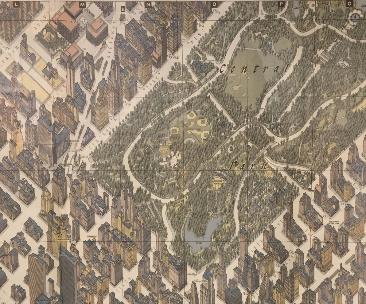
Herrman Bollmann, New York City Picture Map: A 3-D View of Midtown Manhattan (1964)
–but the object of mapping is inverted in the elegant The complete absence of greenery outside the park in Barnard and Chaya’s Central Park Entire, which takes stock of the entire content of the park.
Bollmann’s image of each and every building of Manhattan renders the park as a counterpart to the built landscape–a set of distinct trees, as if to remind viewers of the care of its construction.
The growing depletion of green space in an age of rapid real estate turnover has led few to detect the variations the green, or not just compartmentalize it in a blur.
Rather than chart the dispersal of a generic tree-by-tree census as that which MapZen created of San Francisco ‘s range of street-trees show their clustering as a sort of virtual green space along streets–and by which one can detect the matrix of streets, even once they are subtracted–as a dispersed green space, including acacia, martens, gingko bilboa, cherry trees, red maples, ficus, olive trees, magnolia, loquats, stately Victorian box, and evergreen shrubs in its microclimates–all noted by individual green dots. The export from a street trees dataset from SF OpenData, helps allow the range of 116,000 trees across the city better pop out to its viewer.

Lots of Dots: Trees in San Francisco

In contrast, the static drawn map by Barnard and Chaya was intentionally created to value each and every tree in the rare block of green space of Manhattan. The map’s very subject may call for a denser sort of tree-by-tree mapping, and not only better reflects deep observation of local variety by the cartographers, but the distinct value of the relative rarity of trees in New York City’s urban space–and the unique sense of open space that the park still offers visitors. For in New York, the park trees are a precious resource–as well as a microcosm whose arboreal treasures one is able to unpack. Barnard and Chaya’s Central Park Entire locates some 19,630 trees in the park’s stone gated boundaries byspecies, health, and relation to other plant life to unpack the greatest compression of green space in the city in full detail. The dense microcosm of the park’s trees unpacks the hidden settlement of settlers, native plants, non-natives, and avian-born seeds that create a mosaic of green in the park that viewers can unpack with far more care, focussing on the species and provenance of each in a mirror of the social and cultural mosaic of the more inhabited regions of the city itself.
The project of mapping each tree, stone, lake, and bush in Central Park is a concrete exercise in the pastoral that animated the project of designing the park undertaken long ago by Olmstead and Vaux, bringing up to date the cornucopia of the ecosystem that evolved around the park and within its walls. Indeed, the one-to-one map of each tree in the park creates the same bucolic preserve as a pastoral lists the presence of each plant, tree, river and lake for the reader. If every map is an argument, even an imaginary map, Barnard and Chaya’s “Central Park Entire” (2011) is an argument about the preserve that the park perfectly constitutes from the city that surrounds, or, in a weird turn around, the nature that the city surrounds. The ancient Virgil evoked a landscape where “Spring adorns the woods and groves with leaves,” when “birdsong is heard in every secluded thicket,” and Barnard and Chaya mapped the park as a truly green world, outside and beyond the city, and frozen in a permanent Spring in glorious color. As much as Snyder saw a technological ecosystem of built, they offer a Virgilian catalogue of trees, flowers, and plants verged on a primer of ancient botany. Chaya and Barnard link their observational passion with graphic design, in a self-funded project of mapping that is a testament to preserving arboreal variety, and a sort of time capsule of urban green space.
Indeed, the map provides a sort of analytic attention to detail that few existing maps made today approximate. In registering floral variety in encyclopedic comprehensiveness, the map stakes a different sort of truth claim, indeed, than any of its predecessors, allowing one to view not only range of trees that exist but to depart from its icons to explore the variety of trees within the park itself, returning cartography to an age of exploration by tempting anyone to undertake their own self-designed survey. “Entire” is a sort of cartographical response of painstaking draftsmanship to the new horizon of expectations generated by a computerized GIS, or the promise of the totalistic and comprehensive coverage of Google Earth:
It may be that Virgilian topoi of variety and abundance that seem to shine through the maps’s loving detail. Building on the tree censuses of the Central Park Conservancy, but taking them to the next degree by actual foot-by-foot comparison of the park, they have mapped almost 20,000 of the 23,000 that the park has itself identified. As a recent article on its composition from the New York Times cited Chaya as saying, “This is an example of a map that’s never finished” and a snapshot of the evolving project of Central Park: the map captures the microcosm of plant variety that unfolded over time of pin oaks, European Beech trees and Camperdown elms to London Plane Trees with the wonder of an avid birder; both Chaya and Sibley Barnard are self-described birders of urban space.
The utopic preserve of the park is recreated for readers in glorious detail in this stunningly detailed map. For this post, an entry on Chaya’s map of the trees, landscape, and built structures of Central Park in New York, is an Arbor Day special–for in a sort of preserve of nature in the city, Chaya’s map offers an arboreal museum of wandering and a habitat for birds. This two-year-old map includes short of 20,000 trees of some 170 species–several of which are unique examples in the park and city as a whole–the map charts with new detail every path, rock, built structure, lake, waterway, and pond with a comprehensive updating of the space that was planned designed by Olmsted and Vaux as a preserve from metropolitan life. The scale of this folding map allows inclusion each and every tree in the park, with an implicit promise of future updates. While only some 150 trees from the “original” plantings in the park of the 1860’s, it presents the story of the expansion of vegetal life throughout the park’s confines over almost fifty years, mapping some 85% of its total vegetation with loving detail.
More a living document than schematic guide, the fruit in ways of the expansion of the Central Park Conservancy, which offers it on its website, and at http://www.centralparknature.com, reveals each and every tree as Chaya saw and drew it over the two years he studied its terrain–a composite of drawings, photographs, and repeated consultations and revisions of existing cartographical records with the actual terrain, as if to present in detail every aspect of the park whose more regular visitors know its monuments and vegetation so well.
The project of mapping the known–the park’s walks and its pathways and each building–raises the stakes of the content of maps, because the bar is set considerably high: it reveals what one might not notice, despite the huge collective knowledge of so many city-dwellers and park-walkers, of providing and compiling account of observations that extends beyond the notion of mapping the unknown, and indeed presents the sort of detailed accounting of vegetation and landmarks that perpetuate a complete cartographical fantasy.
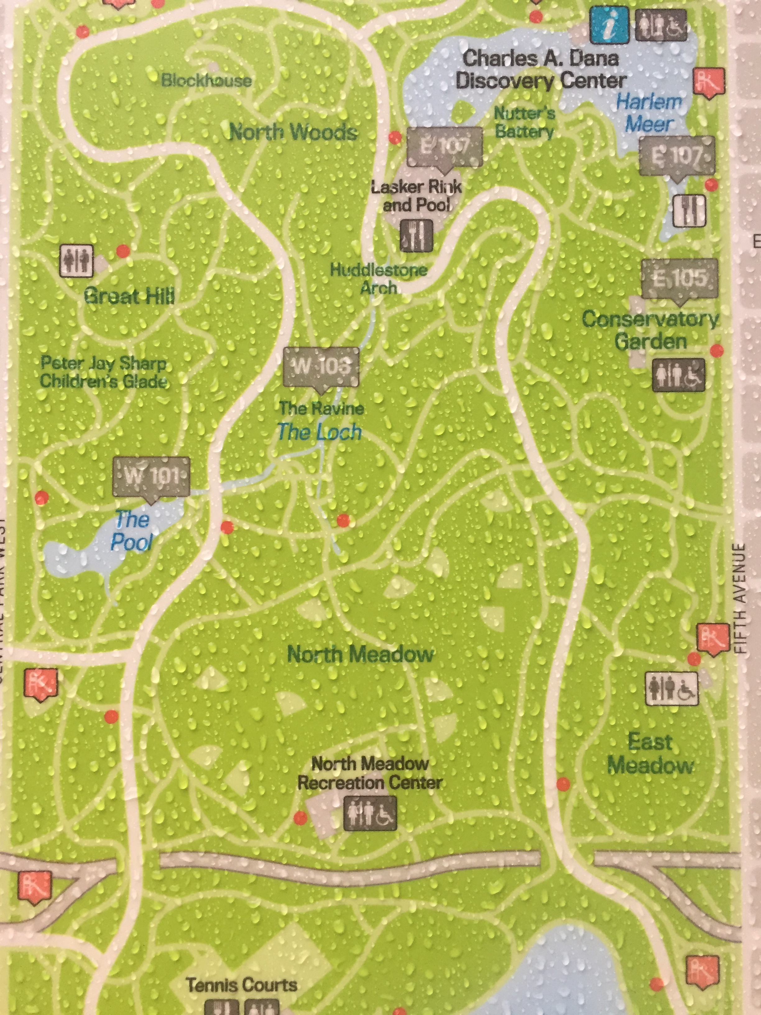
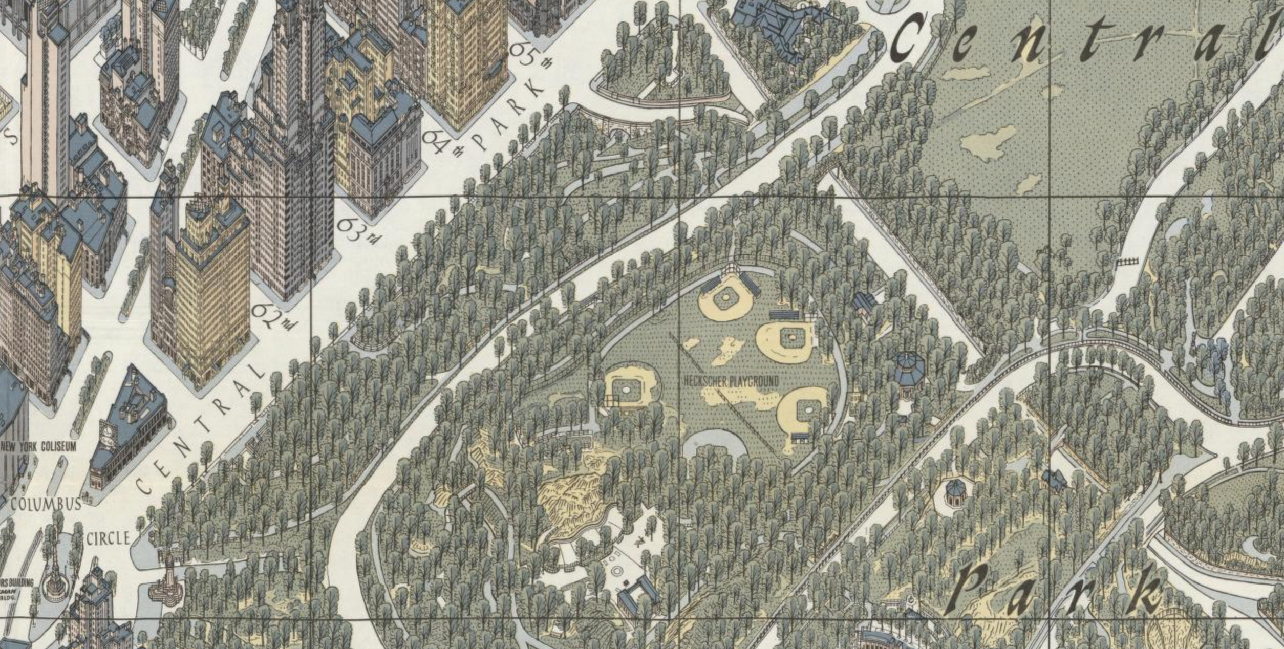
To put this in some cartographic context, contrast it to the image of the Central Park Conservancy, in black-and-white, which is confined to the paths that traverse areas of the park which highlighted the dispersion of emergency call boxes:

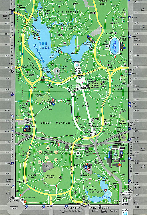
Or the range of information designed for park users in this far more detailed colored, and more iconographically dense, image of the sort that probably provided one of the basic templates for Chaya’s “Central Park Entire,” but notes restrooms most clearly and elides arboreal variety in a uniform kelly green:
The above map, that similarly bound a green rectangle of nature by blocks of anonymous urban grey, provided a somewhat more detailed and text-rich colored surface, but without the detail Chaya’s comprehensive map boasts of every square foot of the park’s terrain. For the park-goer, this is a sort of mythical return to the Borgesian fable of a map of one-to-one size, in ways that encourages readers to navigate its copious vegetative variety:
The map tells a story–and presents an argument–about the extent of the graphic techniques and representational conventions that Chaya adapted, drawing from pencils and sightings to software, to design the map from a set of basically abstract conventions and a standard palate to refine the image on which he worked during visits to the site he so intensely mapped. Indeed, the visits that he made over two years to the park allowed him to document some 85% of its entire vegetation over the 843 acres of the park with a patience that reveals a cultivated reverence for its land.
The careful iconography of the map goes far beyond a simple road map, in other words, to focus on the ‘true inhabitants’ that are growing in the park, the site of some of the sole representatives of entire plant species. Speaking of Arbor Day, an excerpt from its legend reveals the fine distinctions by which the map orients readers to the park’s arboreal life:
An abbreviated story of the map and the two-year period of its planning and making is nicely told below by the mapmakers themselves:
Rather than allow the green space of the Park to recede into the unclear interface of transit diagrams–a light green space that stands apart form the destinations of travelers–the map is a condensation designed for park wandering, and virtual travel among its trees.


admirable