
“All Gaul Was Divided into Three Parts . . . “
The cynicism of the Republican party’s attempt to redraw the electoral map of the United States certainly withdraws from reality: when you’ve lost a big election, just take a few steps back, breathe deeply . . . and re-write the map. It’s hard to take seriously the attempt–as if gerrymandering wasn’t recent history. If votes didn’t materialize the first time, just change the rules of the game: these are only conventions; why not protect the economic homogeneity of the electoral district to get more votes? We’ve recently obsessed as a nation with questions of boundaries and drawing firm lines in maps, a pursuit which hasn’t got us that far in international affairs, or anywhere worth being.
If drawing boundary lines in the sand or in Ohio are powerful exercises in power, my favorite case of delineating boundaries for readers is from the popular comic, drawn by Uderzo from 1959, each issue of which began from the stark boundaries of an imagined ancient world: even without consulting Ferdinand Lot’s Les invasions Germaniques: La pénétration mutuelle du monde barbare et du monde Romain (1945), the identity of Gaul/France was the recurrent theme of Goscinny and Uderzo’s rendering of the adventures of the blond Gaul Asterix and his band of fellow-villagers as they continue to resist Roman invaders to their lands. Indeed, the Gaulist conceit of the cartoon series plays with the idea of national and linguistic diversity in the ancient Roman world, imagining a past of fixed territories, clear borders, and national aggression that mirrors our own, or mirrored what would be a clearly defined region of Gaul–as if by a modern boundary line–from which a magic potion allows them to undertake the against-all-odds deviance of one city, not yet fallen to the Roman troops, and to preserve their identity even if they are within the Roman empire.

The potent image of Gallic resistance that the comic strip has inspired has spawned theme-parks, stuffed animals, live-action films, and legions–sorry–of admirers, as well as probably having directed the imaginations of more kids to antiquity than any other media. (So powerful were the connotations of resistance that when Uderzo’s daughter wrote a column for Le Monde in 2009, protesting the sale of the series to the French publisher Hachette Livre, she wrote that it was “as if the gates of the Gaulish village had been thrown open to the Roman Empire,” to give voice to fears that the resourceful cartoon characters discovered in 1959 would be exploited by marketing, as if they would be Disneyfied–a fear Uderzo himself counter-charged was only motivate by greed.
Uderzo’s now-iconic “Map of Gaul” introduces every one of Asterix’s adventures. But the map becomes a them of a relatively early book in the multi-volume collections that is un-coincidentally entitled Asterix and the Goths. On the comic book’s cover, the imaginary boundary line that bound Gaul/France was concretized for readers of the strip, as the boundary line between became the stage for action: Uderzo marked a dashed line (familiar from road maps or national atlases) on the ground, to essentialize differences between France and Germany, if not intentionally to mask how the historical determination was actually more fluid than Uderzo rendered the boundary line between Gaul and Germania for readers, but which the wily Francs were about to invade, even if that meant leaving the flagstones that Roman conquerors had used to pave roads in Gaul.

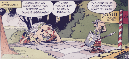

Historical accuracy or verisimilitude wasn’t exactly the point for the authors or readers of Asterix. But celebrating a mythistory very much was: much as our hero stands for the defense of Gaul against the invading Roman Empire, the looming shadows of the helmeted Goths in this image echo the Bismarck-style helmet that date from World War I, and cause our hero to turn his attention from the Roman legions that Obelix stands posed to clobber, reaching for the sword to face a new enemy. After all, the colors of the map are evident in the land that he defends: Gaul is green; Germania yellow. The border marking is clear, and the border sign notes the different fonts used in each land just as the Germans speak in Gothic letters in the speech bubbles in this comic book.
Demarcating regional boundaries was of course not so much a reality for the ancient world, or migratory Goths, as they are in historical reconstructions. But the comic essentialized France by the gallantry and derring-do of its Gallic ancestors–as the counter-weight and barbaric other of the Goths to the east. In each adventure, Gallic wiles defied the formal boundaries displayed in the frontispiece in Uderzo’s map of Gaul’s division into three parts in they year 50 BC, where all of Gual is indeed divided, . . . save one town that holds out to the north in Caesar’s time . . .
The regional divisions of Gaul are pseudo-scholarly, if not antiquarian, and the joke of the towns that are revealed, surrounded by Roman camps, by the magnifying glass, is matched nicely by the cracks of the earth caused by the cracks in the Gallic landscape, as if by an earthquake, caused by the aggressive planting of the Roman standard in the south of France, casting more than a shadow over the region’s fertile plains.
There was a something of a tradition of an imagined creation of boundary-lines in Renaissance editions of Caesar’s Commentaries on the Gallic Wars, to be sure, that is echoed in Uderzo’s clever cartographical cartoon. The insertion of such boundary lines into the landscape is reflected the increased national segregation of regions in Renaissance maps and national atlases. They paralleled, to be sure, the fantasy among Germans that the region Tacitus described to the Romans in his Germania revealed the antiquity of the Germanic people. National maps were popular in France from regional maps from 1550, or the national atlases of Bougereau and others, and commissioned by the monarchy–even if they were far less colorful than Uderzo’s cartoons.
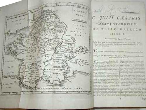
The notion of the invasions of Goths in a later date was rendered as a cartographical violation of French territory in the great medieval philologist and demographer Ferdinand Lot’s 1935 Les invasions germaniques, an erudite study republished in two years as Les invasions barbares, a work whose cover oriented the work around its central subject–France, in the guise of Francs–despite Lot’s positivistic evaluation of historical evidence.

A subsequent edition of the map was noticeably far more reticent:

But let’s go back to the comic books. Uderzo’s boundary line in the two-color Asterix map is an actual sequence of dashes, thick dashes, beside a marker which seems to have been drawn in the Gaulish/Roman side–Gaul is predominantly indicated in the sign, and, betraying the question of who wrote/drew it, the presence of Gaul in the Roman Empire is noted as something of a parenthetical afterthought. This is a boundary line for twentieth-century observers of the map, in ways unavoidable when the first comic was printed in 1959: Asterix is a national hero who brilliantly and craftily defended, after all, occupied Gaul with ingenuity and help from a magic potion. The region’s bounding is totally unlike the tribal distributions that characterized Europe’s peninsula:

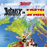
And so it’s not a surprise that maps are always coyly present as a conceit in Asterix, as well as national identities that the Gallic hero visits with or without his local bard, including not only Spain, England, and Rome itself, but even America. This fantasy of mapping was part of the fun, as well as part of the creative anachronism. Why were maps such a recurrent part of the comic, save as guides to narrate the Gaul’s worldly adventures?
Asterix was only something of a semi-serious hero who defended the cultural boundaries of occupied Gaul. But the defense of occupied Gaul was of course a powerful motif in the twentieth century, and the recurrence of maps in the entire series–from the brilliant frontispiece that begins each book, and is included below, by way of summation–repeatedly employed maps as the perfect stage for Gallic ingenuity and wit. The man from Gaul had a certain international fame recognized on the covers of later volumes:
Well, that combines a map and aerial view, but seems straight out of a classroom map, if not a Michelin touring guide. But Asterix and Obelix encountered plenty of signs like that of Paris carefully marked on their travels and itineraries across the ancient landscape that looked suspiciously modern in the iconography of their design:

But the line between Gaul and Germania, or the land of the Goths, is the on-the-ground view of the clear demarcation that existed in the minds of all the Gauls at that time, runs the conceit of the comic book, or, er . . . all except in one town.

Such is the beauty of maps, and their power as iconic images. It’s not surprising that such resistance was shown when Uderzo, who had worked so lovingly and hard to create these characters got slammed in the national press in 2009 by his own daughter for planning to sell the franchise after his own death as betraying a national hero to “the modern-day Romans–the men of finance and industry.” Uderzo eventually appointed his own assistants to continue Asterix’s adventures.


