
The map may not be the territory. But it shapes one’s relation to the territory–and to the presence of water in the land, as well as the land itself. John Wesley Powell had a clear idea of the importance of mapping the sustainability of his audience’s relation to the new nature of the aridity of the plains states and western territories in the 1870s, when he used his deep knowledge of plants and foliage of the region that was distinguished by a deeply fragile economy of water to try to convince the U.S. Congress of re-organizing the region’s settlement, in the face of increasing hopes for its development: by bounding the area beyond the hundredth meridian west as the “Arid Region,” as if it were a truly unknown land, not subject to the practices of surveying rectilinear boundary lines that the had extended west along the Mason-Dixon line, Powell sought to convey a better understanding of the permanence of drainage zones of the region as the best possible ways of understanding and planning its process of settlement in the way that would be most helpful to future residents, boosterism of the importance of young men going west to find futures notwithstanding.
Indeed, the mapping of how the “Arid Region” of the United States could be settled by John Wesley Powell created as the second Director of the United States Geological Survey, a post he held from 1881–1894, but which he had first expansively described in 1878. The United States Congress followed Powell’s recommendation to consolidate the western surveys into the new U.S. Geological Survey, and he long sought to create a map capturing the fragile water ecology of the American West. The completion of his classic report on the region first suggested a new relation to the distribution of water in the region in ways that would best serve all of its residents, and in his later map, he tried to articulate so clear a relation to the region’s future settlement. Powell’s view on the need for systematic irrigation of the region stands in almost polemic relation to the place that the western states held in the spatial imaginary of the Homesteading Era: indeed, his insistence that led to the charge to undertake a systematic irrigation survey of lands in the public domain of the wester United States in 1888, long a topic for which he had agitated, and his map of the region reflected a demand to integrate a topographic survey, hydrographic survey, and engineering survey of the region. Perhaps the map offered a new sense of the territory, if “territory” includes the waterways that would be able to adequately irrigate all open lands.
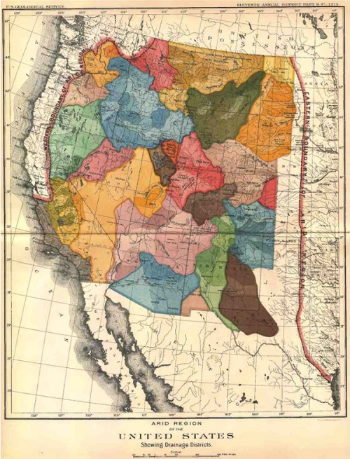
For the reception of Major John Wesley Powell’s attempt to map what he called the “Arid Region of the United States” reveals both he difficulty in mapping the relation of water to the land, and the appeal that a piece of paper might gain over time. The detailed map provided something of a ground plan and register of how the arid region might be best inhabited, and of the relation to the land and landwater of a region’s inhabitants. And it provides an early recognition of problems of water management and distribution in the western states–captured in its naming simply as the “Arid Region” as if to set it apart from the plentiful water in other regions–that later eras began to appreciate in ways that Powell’s contemporaries were less able to see in his ambitious attempt to reorganize the management of its regions around its multiple inland watersheds that he had hoped to canalize. For Powell’s ambitious 1890 remapping of lands west of the 100° meridian in the United States tried to encompass their unique aridity and to pose a solution for its future inhabitants with special attention to its drainage districts–as discreet riverine watersheds.
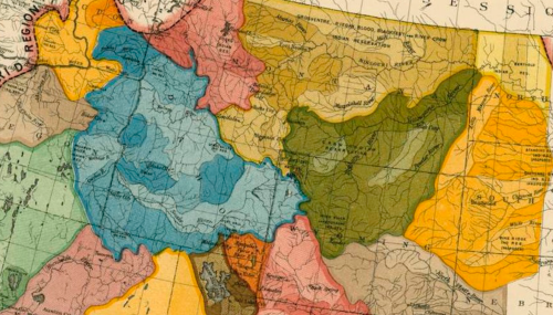
 Arid Region of the United States (1890); detail
The best practices that motivated Powell’s map as a basis to orient the government to the land’s groundwater. The distinctive scarcity of water in the western states became evident in a time of sustained drought, giving unexpected currency to how Powell’s map reoriented readers to the “Arid Region of the United States.” The brightly colored map to which the explorer, geographer, and anthropologist not only dedicated an extreme amount of attention in his later life, and of which he became something of an evangelist, suggests a early recognition of the scarcity of water and its management, in an era when there is a specter of considerable anger around poor practices of water management in much of the western states, tempered by an expectation that groundwater would be available for farming and irrigation.
The rivers in the United States are quite widely distributed, leaving much of the western plateaux at a distance from riverine waterways–
–and the image of Virgin Land so deeply ingrained across that regions settlement that its unique character of low rainfall and widely dispersed water sources was erased in the spatial imaginary which replaced the detailed map Powell of the administration of groundwater in the western states that Powell had created with his surveying team as a guide to the region that he knew so well, and which he sought to communicate when he became second director of the United States Geographical Surveys (1881–1894). The governmental office did not give him authority to organize , but to create a new map that might better organize the nation to the lesser rainwater in what was known as the Great American Desert. For Powell attempted to re-orient homesteaders to the imperative of western migration through the map, by organizing water administration and the future prospect for canalization in order to grow prospects for the irrigation of the region and its future farmlands that have considerable ethical power to speak to us today.
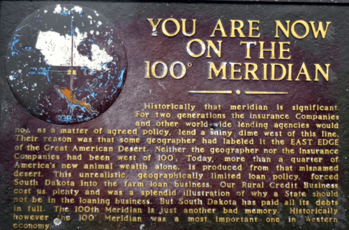
Powell dedicated his ability as a surveyor to conceptualize a basis to settle these unknown lands of unsettled expanse extending to the Rocky Mountains that provided a central means to revise the settlement of its frontier and mapping the nation, in ways that gained increased attention and relevance as questions of water distribution plague the west, and even seen as a vision and lost opportunity for distributing water in more economic ways. Given the absence of an authoritative map to mediate or concretize a compelling relation to the land in the western expanse, the homesteaders that settled the region approached it eagerly without knowledge of what a black plaque on the meridian so ominously warns about why “for two generations, the Insurance Companies and other world-wide lending organizations would not, as a matter of agreed policy, lend a shiny dime west of this line.” Already by 1850, insurers not so cryptically designated rates in the large areas of Nebraska, Kansas, Utah and New Mexico as Class Five, “as per special agreement.”
 Map of Rates of Insurance in the United States, 1850
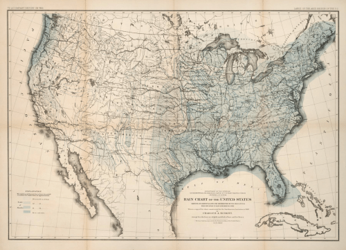
The tacit reasons for such a retrospective warning about investment was based on a clear sense in the recent Statistical Atlas of the United States (1874) that a dividing line of the meridian reflected a difference between green grasses and dried browning fields, where the scarcity of rivers defined not only a distinct ecosystem, but reflected a diminished level of rainfall that characterized the “Arid Expanse” of the newly settled West, but whose scarcity of water had not been effectively translated to social or political practice.
 Statistical Atlas of the United States (1874)
At a time when late nineteenth-century American homesteaders promoted the region as a “New Canaan,” John Wesley Powell oriented the nation to the unknown lands by a radically revisionary map that took into account of its low level of land-water in order to promote its future settlement. Toward the end of his public career when he had led multiple teams of expeditions and surveying missions of the Arid Region, Powell sought to remap the administrative divisions of lands west of the Mississippi and before the Rocky Mountains to account for its absence of groundwater–as revealed in a recent remotely observed distribution of rainfall across the country from Jet Propulsion Labs and NASA—
 The Ohio State University/NASA-JPL/Caltech
The map provided something of a ground plan and a grand plan define the largely unmapped American west, at a time when questions of water usage and access were not only unknown, but poorly understood or elided: and which have only quite recently been appreciated once again for the specific polemic value that they had, not only as a map but as the witness of a land of increased water scarcity. For Powell’s dedication to the process of remapping the land to allow its active canalization and redistribution of water considered the habitability of western states in closer relation to questions of agrarian economy than most state governments or governors were however ready to accept–and unlike current maps of the west continue to reveal little concerns about the profound sense of water-scarcity that defines the region in a deeply existential way–dividing the edge of the geographic conceit of a Great American Desert. In so doing, he sought to map the presence of people in a land that seemed inhospitable–but to map the presence of people in the landscape by mapping their water usage against its water scarcity.

1. It is hard in the current age of retinal over-stimulation to exult in two-dimensional geographic visualizations. Indeed, despite the elegance of the considerable graphic economy and loving detail of Powell’s attempt at accounting for the relative absence of groundwater or water sources in a region whose basins and plateaux made it difficult (if not meaningless) to divide and administer water-use through units determined by parallels and meridians. Powell divided regions of equitable water usage along access to water in river basins, imagining a network of irrigation canals that criss-crossed the region, adopting a sophisticated notion of the limits of water usage and economy–perhaps overly so for most viewers–to call for circumscribing locally shared access to water resources by organize units of government in the western states around what he called their “drainage districts” to distribute the scarce resource of water in the region in the most equitable manner. For Powell, such units best defined the region’s future economy, rather than the now-discredited anthropocentric fallacy of climatological wishful thinking so pervasive in the late nineteenth century that “Rain follows the plow.”

The obstinate optimism of conceiving of the western lands as open to future expansion and available for unending settlement and the exploitation of resources was a failure of cartographical reception whose effects are still being felt. For if Powell’s maps promised to re-write a relation to the limits on the presence of water within territory, by synthesizing local surveys to generalize a collective relation to expanse around river basins, in order more effectively to mobilize existing resources in new ways, the rejection of the Powell map of the Arid Region as guidelines for its future settlement represents a failure to make land management central to its settlement, and a over-persistent optimism of promoting an distorted imagined landscape rather than an accurate map.
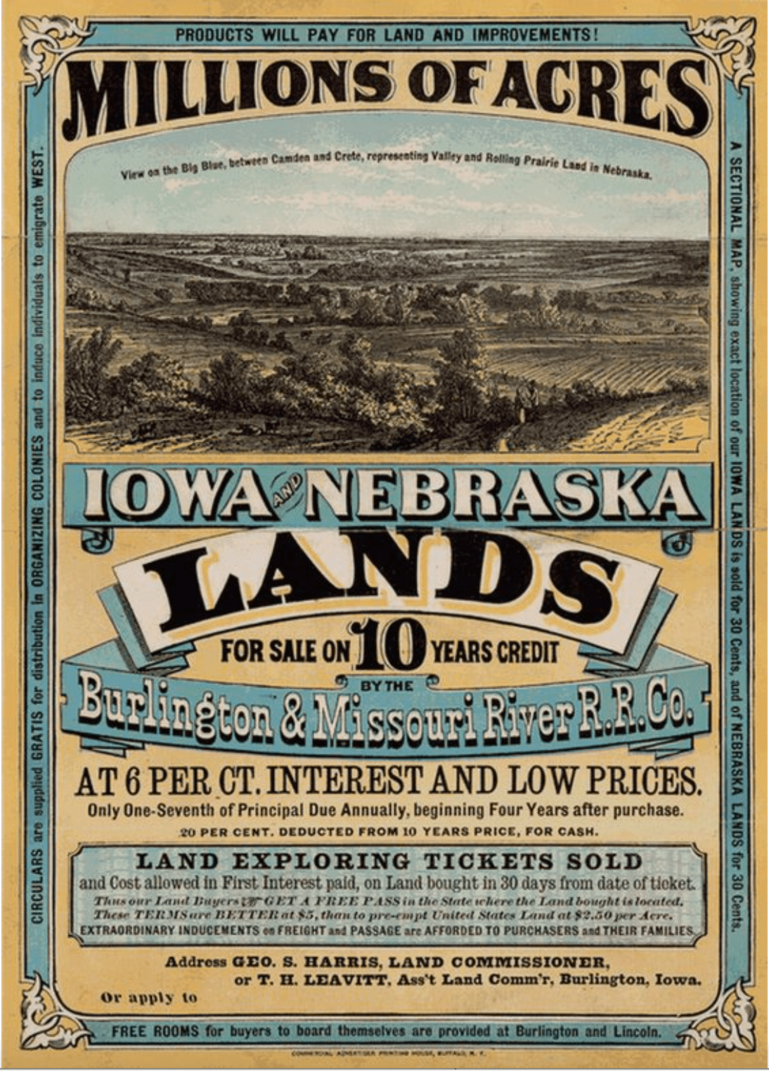 Poster advertising cheap lands for sale by Burlington & Missouri River Railroad (circa 1872)
How the public lands of the west might be best distributed rested not only on topography, but the peculiar manner by which rivers were already distributed across the land and the most likely ways that the needs of future residents could be realistically met.
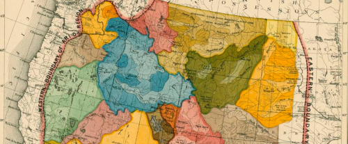
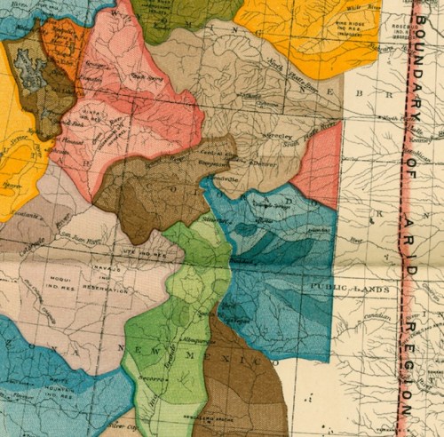
 Detail from Powell’s map representing the scarce river basins west of the 100th Meridian W
So much uncertainty about what lay in the expanse extending ‘beyond the 100th meridian’–questions based in the quality of land in the Arid Region which received so much less rainfall–to create blind certainty of the possibilities of its settlement. For even as homesteaders misleadingly promoted settlement of a new Canaan and region’s fertility for future agricultural cultivation, the new practices of land use that John Wesley Powell increasingly realized from his deep familiarity with the land led him to propose a remapping of its future settlement that has, while widely rejected, become an emblem of a road not taken in the expansion of western lands.
In order to resolve certainty about the region’s habitability, Powell remapped the territory in hopes to better administrate the national lands of the Public Domain in ways that would render them as habitable–in hopes better to imagine the integrity of the West as under the administration of the United States. While vigilante anti-federal protests may have obscured the question of land management practices, Powell saw these as central to ensuring good practices of inhabiting the drier lands whose ranges, canyons, and basins he had so often explored with surveyors, assaying the courses of its scarce rivers and still scarcer groundwater when little water came from the heavens–and weather couldn’t be reasonably expected to follow the plow.
Powell asked readers to contemplate the question of water availability that Homesteaders had promoted, blind or blithely ignoring the possible futures of its settlement.
Powell sought to re-write the relation to the Arid Region as a continuous entity defined by unique nature of its water usage, to make the system of rivers that ran into distinct drainage basins the most rational way to understand the land’s division from the perspective of its future inhabitants–viewing the jurisdictional of the West into states as something that would create inevitable undue stress on the water needs of its future residents, in the midst of a general rush to sell public lands. As a mapmaker, Powell’s sincere hope when he led the United States Geographic Services to use a comprehensive survey of western lands to determine remap its areas of jurisdiction over water by irrigable regions, remapping the Arid Region into irrigation zones to better correspond to future residents’ water needs, and better conform to watersheds, provided the most democratic means to stimulate its future growth in viable–and ethically supportable–ways, as well as in ways that allowed for economic development that met the conditions of water scarcity that unified the unsettled region and, he believed, would allow it best to grow.
Powell’s map of the Arid Region west of the hundredth meridian asserted a radically new relation to the land, and of the need to calibrate government policies to the region where less than twenty inches of rain annually fell–but took the region’s water scarcity as grounds to suggest the compelling need for adopting a new relation to its land, starting from foregrounding unique environmental conditions not readily visible on most maps.
Powell’s map re-presentd a region in terms of the compelling basis for water use, reordering counties and states on lines that would meet the needs of future residents. Rather than being an arbitrary line, decreased rainfall in the region west of the meridian–earlier not known to “the geographer nor the insurance Companies” and seen only as the edge of the Great American Desert–was defined by its dramatic scarcity of rainfall in relation to eastern lands, and compelled a different relation to land. The “Arid Region” had been only recently mapped as an open part of the United States, but one where insurance companies and other lending agencies “would not, as a matter of agreed policy, lend a shiny dime” was something where dams, diversions, reservoirs, and projects of irrigation would be built to increase the local availability of water, rationalized by expansive understandings what constituted “beneficial use” and the ownership of water rights.
Powell preached the possibility of land conversion–and the necessity of irrigation–as a corrective to the blatant promotion of protest of settlement promoting homesteading and settlement of open lands at cheap rates, designed to entice migrants to relocate to low-cost lands that seemed limitless, but were openly misleadingly in representing the diminished value of lands where water often lacked and rivers were remote.

Detail of poster advertising Burlington & Missouri River R. R., circa 1872
Amidst a rash of speculation on what were once public lands, Powell, the one-armed son of a Methodist preacher, evangelized a new vision of brining water to the inhabitants of the west through maps that articulated a new relation to water rights and water use, advocating the integrity of basins as a way to guarantee sufficient water to all. While the map encoded a new relation to the region’s development, the attention that it directed to water scarcity sought to describe the new relation of residents to the region that gained little traction, but Powell’s dedication to it provided a new way of understanding the significance of the public ownership of western lands.
2. When Powell mapped the coherence of the Arid Region in relation by access to water for future settlers using the equitable distribution of water in its drainage basins, rather than the jurisdictional lines of the new western states, he sought to preserve water usage across the Arid Region for the U.S. Congress. Powell hoped that Congress would recognize conditions of water scarcity in a map of the western states. Powell proposed his map not as an elegant aesthetic rendering or cartographical solution to the individual’s relation to water stresses across the region, but to bring the government to recognize the unique grounds of the relation of its residents to water-use, hoping to rewrite their relation to water as a form property: while common law moved from land to declare rights of water ownership, in a region of plateaux provinces whose rivers he had explored in detail, Powell argued that water use was best conceived around basins.
Although the map would have been a basis to create a massive project of irrigation, for which the funds were lost, his map started from the question of the region’s water scarcity d to present a ‘big picture’ that hoped to reorient the administrative and governing functions of the land, so that it would conform to what he saw as its defining geographic features. In an amazingly comprehensive fashion that distilled topographic and geologic knowledge, he foregrounded the hydrography of the Arid Region: while land usually provided a basis for the “commons,” the relative scarcity of water in the western lands should organize their administration around drainage basins that would best allow residents regular access to water. Only by doing so, he asserted in lectures given with his maps, to create an equitable collective access to water rights based on need, and not the common law system of riparian rights, where ownership of land bordering rivers defined its use. The economic re-envisioning of the Arid Region was ambitious, and proposed that riparian rights were an outdated manner to apportion water use in a region where so few water sources save rivers existed.
Powell argued that the integrity of rivers’ course should define and constrain the relation to its settlement. The seven shades by which he distinguished individual watersheds and drainage basins across the Arid Region provided a basis which he quite ambitiously hoped would re-orient Congress to its public administration: beyond a cartographic record, the map encompassed a synthesis of human relations to the water stresses of the region. The resulting image was a monument not only of environmental history but an early document of human geography. For Powell’s “map” of the Arid Region staged a novel argument, by re-writing of the organization of states and the administration of formerly public lands west of the Mississippi. In an area of the increased eagerness to prospect public lands, and divide “open lands” of the Public Domain for private real estate, the drastic revisioning of how the map organized the territory encountered increased opposition, because it cut against the free market ethos that already mediated–and increasingly dominated–the sale and division of western lands.
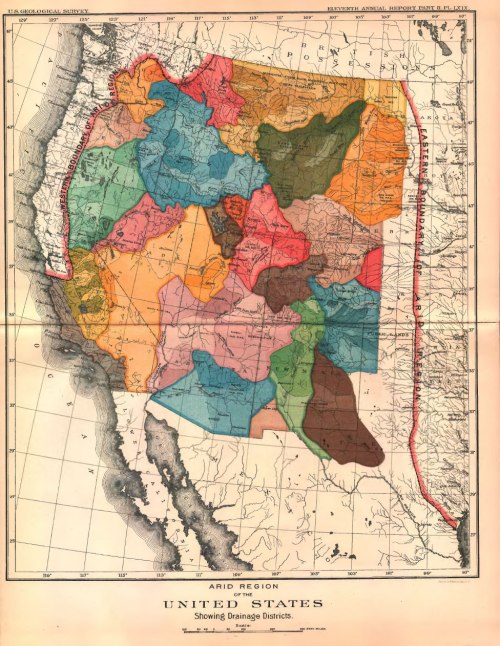
John Wesley Powell, Arid Region of the American West, Showing Drainage Basins (1890)/Courtesy of University of Denver Penrose Library
Powell presented the map of the Arid Region as a polemic model for persuading audiences of the ethical and economical need to re-write political subdivisions of the lands west of the Mississippi conforming to the scarcity of water in a region where rainfall was less than twenty inches a year. Although water is rarely seen as a form of “commons,” his map began from the presupposition that in a truly democratic agrarian society, water rights were basic to the commons, and that the restructuring of water rights west of the Mississippi had to reflect reasonable rights of its redistribution: constructed to have the impact of a vision from a mountain-top in the Rocky Mountains or overlooking the Colorado, the map organized areas of the Arid Region along the just or equitable apportionment of drainage basins or watersheds, aligning water rights with the distinct topography of the region by offering a selective record of rivers’ courses.
For the map re-presented the Arid Region by the possibility of its future irrigation and the dependence of its settlement on irrigation and water rights, and it provided the basis to argue before Congress that rather than being seen as Great Desert–apportioning its water rights in order that its future development was not guided by real estate speculation or result in the painful tragedies of dramatic water shortages that would result from disrupting the integrity of the drainage basin, effectively inviting a monopoly of water in the region by not adjusting notions of property to the region’s distinct topography. The map revealed the lack of logic by which existing state lines abstractly divided public lands determined by straight parallels, irrespective of drainage basis, and divided mountain rivers in ways that would only pose problems for future settlers. While Powell’s proposal for local control of water use never won much attention for fifty years, his persistence in advocating securing local control over watersheds of western rivers now seems almost providential. Indeed, the attention in his map of the Arid Region to the integrity of place contrasts to the poor policies of water management in an age of globalization, where best practices of water management and conservation are increasingly challenged or unclear in an age of drought. Drawing from Powell’s familiarity with the region’s ravines and rivers whose waterways he navigated widely in the late 1860s, his map of the Arid Region placed importance on mapping the specific nature of land-use in the region, reclaiming the role of place in the securing of local water rights: rather than allocate water by entities that were determined by the map of western states, Powell advocated mapping based on need.
 John Wesley Powell, Arid Region of the American West, Showing Drainage Basins (1890)/Courtesy of University of Denver Penrose Library
A practiced polemic writer who had crafted a detailed argument about the region’s development, Powell argued that the entire region between western and eastern boundaries demanded unique attention to which common law principles adopted in the rest of the United States did not apply: the Arid Region be reconfigured around principles keeping water a common good by ensuring the best possibly administration of local water rights rather than understanding land ownership as the basis to determine and assign water rights, and that the region’s actual bounds should be dictated by nature, and by the question of water scarcity, in ways that distinguished it from the abundance of California’s Central Valley or the model of agricultural development in the midwest or eastern states.
The rigorous degree of attention Powell dedicated to re-mapping the “Arid Region” of the United States developed his personal explorations of the region in hopes to reorient the nation to its newly acquired frontier. Although there seems an arbitrary bounding of the Arid Region at the hundredth meridian–the “eastern edge of the Great American Desert” was long the line beyond which insurance companies would “not, as a matter of agreed policy, lend a shiny dime” with other lending agencies. But the revisionary nature of orienting the nation to the “Arid Region” as a boom in land prospecting directed increased attention to the public lands beyond hundredth meridian; Powell astutely argued that the Common Law terms by which the division of land in the eastern part of the nation had proceeded had little application in the quite different ecological conditions of the west, which it would be unfair to apply economic conditions and criteria that were extraneous to the low landwater of the region. If technologies of ground extraction eventually provided a basis to furnish land-owners in the region with the lavish amounts of water demanded for farming, Powell’s plan proposed a new economy of water as central to the future equitable development of the western states to better suit their residents’ needs.
Despite the promise of free, open land in the public domain enticed farmers and families to move beyond the Mississippi, Powell redimensioned the nature of a region mapped by insurers and money lenders as the most disastrous for investment and of unclear profit–

Powell used a far greater familiarity with the local constraints of the Western states to better orient the nation to what he saw as the future needs of the unsettled region whose canyons and rivers he had explored. By removing the territorial divisions that the expanded United States had proposed to bound administrative areas, he divided the map of the territory into colored regions of distinct drainage basins, Powell undertook the task orienting the nation to the possibility of its management that wrestled with the problems of its water scarcity by taking serious stock of the problems that they posed, filling in an immensity of selective local detail about its river network to advocate the need for new systems of irrigating the land the did not derive from riparian rights in the common law tradition, that gave landowners unrestricted use of all water flowing across their property.
2. Powell enlisted contemporary cartographical expertise of the late nineteenth century to embody a region where the extreme scarcity of water occasioned a new notion of property rights and stake a clear argument of accommodating to its meager water sources in a democratic fashion: given the lack of water to satisfy all residents of the Arid Region, and not link water rights to frontage and allow land speculation oriented to where rivers lay, Powell sought to link the redistribution of water in the Arid Region so that it was primarily understood by an outdated concept of water use. If the seven shades that Powell used to map the exact courses of its rivers’ extensive drainage basins is all that remains of the detailed irrigation survey of the Arid Region he had hoped to conduct until Congress denied it much-needed funds, the map is not only aesthetically elegant but writes a detailed account of future settlers’ relation to the land.
For what would be Powell’s last comprehensive map of the entire region he had mapped in specific and whose landscape knew so well embedded a detailed account dense with possibilities for irrigating what were public lands in order to make it possible to create a basis for democracy among the farmers who would live in the western states. For in creating the elegant map, Powell was trying to rewrite a relation to the land, framing a relation to there region as carefully as Powell classified species of flora and fauna he collected and observed across the arid regions’ canyons, ridges, and plateau, and his naming of rivers’ turns, waterfalls, cliffs, overlooks and lakes, embodying what he saw as the distance geographic reality of the aridity of western states. Powell’s map preserved a sense of place that was not only deeply personal, based on first-hand voyages down individual rivers from the Green to Colorado, but an image able to synthesize the ‘big picture’ of the unique place of water and a model of water-usage across the West’s Arid Region.

Powell devised the elegant map orienting viewers to drainage districts. By proposing a rewriting of state lines, at then end of his direction of the United States Geographic Survey. In the subsequently printed map, the smaller font to the “Arid Region” to the “United States” and the drainage districts–or basins–echo his argument that democracy in the west depended on the assignment of a primacy to new concepts of water usage and water rights to the region’s future settlement and agricultural development. As USGS director, Powell met a brief from the US Congress to survey the possibility of irrigating the public domain lands of the West, and used it as a teaching object to respond to the scarcity of regional rainfall. Having mapped many of the individual rivers of the region, from the Grand Canyon to the Colorado and Utah, Powell joined his extensive hydrologic and topographic knowledge, working at Congressional behest to frame a solution to settling a region that recently plagued by extreme droughts.
In looking for guidance from the long-time explorer of the region to frame a future policy of managing the region’s settlement, they may have created a charge for Powell to develop without acknowledging the difficulty of accepting the extensive reconfiguration of the practices of land settlement and allocation he would propose. For in creating a new vision of responsible agrarian development of the public lands of a region long labelled the “Great American Desert,” Powell effectively re-wrote as a region that was ready to reorganize on a local level around projects of collective irrigation and water-use. He did so both on the basis of his familiarity with the difficult distribution of water and water-sources in states like Utah, which he first surveyed and where the actual scarcity of water–as an ESRI map of the region’s landcover and topography reveals–was particularly acute, and the actual division of the state ran against commonsense allocation of its resources.

In Utah, the limits of water sources where crops could be grown without the broad reallocation of resources were in fact particularly pronounced–even more than for other states in the Arid Region. Although we have collectively forgotten this by facilitating and enabling the preservation of an illusion of a near-constant supply of water for the irrigation and settlement of the arid lands, the costs of under-writing such westward expansion are increasingly evident in soil subsidence, drained and over-diverted rivers, and unstable economies based on water subsidies that the land cannot itself provide.
3. In recent years, Powell’s map has been resurrected as something of a “lost opportunity” and road not taken to imagine the nation and the scarcity of water in the west on good grounds. Powell’s radical proposal would have halted the growing market of land-speculation, but is praised for its incredible foresight in recognizing the problem of waster scarcity that land speculators and boosters of the west were so ready to ignore. By calling better attention to the region’s limited water resources, his environmental vision indeed has particular relevance today. At the time of its construction, Powell’s map also presented a revisionary look at a region known for its absence of rainfall, the map was a powerful scientific way to localize water ownership in the Arid Zone in radically new ways that envisioned water accessibility as fundamental to a democratic society: in foregrounding water’s presence in the land, Powell was less of a conservationist, in many ways, acutely aware of the political nature of water that we have only begun recently to acknowledge fully.
Powell’s map has particular relevance not only to the ecology movement, but to the mapping of the anthropocene, for its close attention to the region’s distinctive environment, and for its precocity in defining the defining features by which the region was effectively bounded–rather than seeking only to divide the paper map into regions of different administrative entities for taxation and local government. Any notion of governmentality in the American west, he realized, rested on a different recognition of the limited resources of water and was indeed rooted in questions of water–which he recognized more fully than most mapping of the same region fails fully to appreciate. For Powell, the distinctive hydrology of the west–and distinctive levels of landwater–demanded an alternate model of land management, based on visualizing its waterways as the primary basis to understand its organization, and not the parallels and meridians that defined the newly established states west of the Mississippi, whose semi-arid plateaus rising two to three thousand feet above sea-level and deserts and plains labeled uninhabited ‘territories’ in the 1880s and a frontier far less inhabitable than its coasts.
Instead of map the region’s topography or settlement, Powell directed attention to imagining the future settlement of the Arid Region around the rivers that ran through it. As much as a cartographical document, it wrote a new relation to the largely uninhabited land. Powell developed a close relation to the region by the time he was charged with surveying the Rocky Mountain Region in the late 1870s. But the gospel of conservation that the map that Powell, son of a Methodist minister, designed, staked its scientific value on clearly cartographical terms, and did so in relation to the project mapping the nation.
4. The contemporary with the publication of maps collating rain distribution in the powerful 1870 Statistical Atlas of the United States meant that maps gained an increasingly collective currency as a means of imagining the nation and raised particular questions about the relation of the nation to its less habited land that had invited increased speculation as public lands were sold–but tried to map a new approach to water property in a region that was water stressed. Powell was tasked with “making suggestions as to the conditions under which the lands embraced within its limit may be rendered available for agricultural and grazing purposes”–an early formulation of land development or conversion–the one-armed geographer considered the regional distribution of rainfall across its states to determine which regions might be suitable for irrigation or pasturage, before he arrived at the proposal for a monumental reformulation that sought better to respect local water rights.
The 1890 map was sought to orient the “Arid Region” to the nation in a new cartographic from by attending to the environmental constraints of the region. While that was not only the mandate of the map, it expanded the recent refinement of the legibility of the nation in a new comprehensive model too account for the relation of man to natural resources. Powell’s presentation of information probably met poor reception in the 1890s since it addressed its audience, for all the apparent aesthetic nature of the project, in a learned manner, dispensing with the familiar ordering of public lands, and indeed with existing governmental divides of state governments that amounted to a form of hubris for contemporaries. By giving primacy to ensuring what he understood to be the most viable form of land use, as well as marshaling detailed and exact knowledge of its hydrography, the academic nature of the map was less apparent as an economic relation to the environment than as a heavy-handed rewriting of the landscape that was difficult for both industrialists–foremost railroad companies, but also real estate prospectors–to grasp; Powell’s advocacy of continuing suspending sales of public lands by the Dept. of the Interior during the late 1880s was seen as an attack on the public domain, and an arrogant extension of his expertise into the free market.
Powell’s map of the “Arid Region” has been celebrated as a precursor of environmental responsibility and the custodianship of a local environment. Indeed, Powell had long adopted his ethical responsibility to represent an accurate account of the region’s environment that far transcended usual notions of cartographical precision or expertise. “I have taken the liberty to suggest a system for their disposal which I believe would be adapted to the wants of country,” Powell had written in 1879, “relating to the conditions under which these lands [of the Arid Region] must be [best] utilized.” “The redemption of the Arid Region involves engineering problems requiring for their solution the greatest skill.” His plans for reconfiguring the west were radical, and comprehensive. “The redemption of all these lands,” he continued, as a missionary of land stewardship, “will require extensive and comprehensive plans, for the execution of which aggregated capital or cooperative labor will be necessary,” and which must be “embodied in carefully considered legislation.” Placing more emphasis on the knowledge of local inhabitants of the land than the cartographical power that one might exercise over it, he offered a more sophisticated way of putting people in maps–rather than viewing the region as a space ready for settlement despite the dry nature of its lands.
 John Wesley Powell, Arid Region of the American West, Showing Drainage Basins (1890)/Courtesy of University of Denver Penrose Library
As if in rebarbative response to the vision of an Arid Region defined by the absence of rainfall in the vision of the nation that was already advanced in the “Rain Chart” of the Statistical Atlas of the United States, which had cautioned readers as to its water scarcity in the 1870s, that used color printing to visualize the nation by degrees of blue, as a canvas for future settlement by rendering local differences in rainfall by incremental degrees. The map effectively isolated Arid Region, showing that the bounding of the region by the hundredth meridian was not arbitrary, but rooted in the radical decrease in rainfall west of the Mississippi –and revealed a blanched region, whose lack of light blue either attuned or warned its readers of the difficulties of agricultural development.
 Statistical Atlas of the United States (1874)
As if in dialogue with the attenuated tracery of light blue isohyetal lines in the “Rain Chart” above, Powell relied on his navigation and exploration of the rivers of Arid Region to promote the potential for land settlement despite the scarcity of water across the region– recognizing the constraints that a lack of land water meant for its future settlement. The “Rain Chart,” even for one who didn’t read the accompanying explanatory legend in the lower left of the explaining the isohyets of rainfall of less than a meagre twenty inches, presented a region whose low rainfall posed particular difficulties for agrarian settlement.

But how could a better image of the ‘big picture’ of the region be created? The alternative image Powell presented emphasized the region recast the Arid Region as a region rich with rivers if low in rainfall, whose local irrigation was enabled by a system of dams and canalization that afforded a more viable image of its regional settlement. Powell remapped the region to offer a model for imagining its future irrigation by organizing the region not by state lines determined by a logic of meridians and parallels, but by the local administration of its watersheds, selectively foregrounded the drainage basins of each river, and not its lack of rainfall, to suggest how the flow of mountain rivers provided a basis for collective administration, modeled after the acequia that were employed by Native American inhabitants’ acequia that would be determined for communal water use.
For Powell’s map implicitly advanced an argument for collective stewardship of water resources that has lead it to be seen as something of a road not taken for responsible management of public lands, the map was also a plea for an end to land speculation. Powell’s map condensed the argument already advanced in his 1878 Report on the Lands of the Arid Region of the United States that the eagerness to settle these public lands overlooked the impossibility of ever settlement of high density that existed in the northeast, but rather a model of planned irrigation: whereas in much of human history, water had long been understood as an abundant commons, Powell cautioned that in the Arid Region, “the ancient principles of common law applying to the use of natural streams, so wise and equitable in a humid region, would, if applied to the Arid Region, practically prohibit growth of its most important industries.” The notion of constructing a new map of the western states that would accommodate its distinctive lack of water created a problem of mapping scarcity that ran against the national metaphor of abundance.
Powell seriously accepted the charge to protect the lands as director of the United States Geographical Survey. He had developed an intense identification with the future of the region, and saw his expert knowledge provided a basis to mediate speculation of public lands on the possibility of their irrigation–and encode a detailed proposal of future settlement of the arid lands. Powell had been charged with surveying the Rocky Mountain Region in the late 1870s, or contemporary with the publication of maps collating rain distribution in the powerful Statistical Atlas of the United States, and was tasked with “making suggestions as to the conditions under which the lands embraced within its limit may be rendered available for agricultural and grazing purposes”–an early formulation of land development or conversion. The one-armed geographer considered the regional distribution of rainfall across its states to determine which regions might be suitable for irrigation or pasturage, before he arrived at the proposal for a monumental reformulation of the American west which he believed would best respect local water rights in 1890-91. “I have taken the liberty to suggest a system for their disposal which I believe would be adapted to the wants of country,” Powell wrote in 1879, “relating to the conditions under which these lands [of the Arid Region] must be [best] utilized.” “The redemption of the Arid Region involves engineering problems requiring for their solution the greatest skill.” His plans for reconfiguring the west were radical, and comprehensive. “The redemption of all these lands,” he continued, as a missionary of land stewardship, “will require extensive and comprehensive plans, for the execution of which aggregated capital or cooperative labor will be necessary,” and which must be “embodied in carefully considered legislation.” Placing more emphasis on the knowledge of local inhabitants of the land than the cartographical power that one might exercise over it, he offered a more sophisticated way of putting people in maps–rather than viewing the region as a space ready for settlement despite the dry nature of its lands.
5. The possibility of such redemption became a cause that Powell pursued with complete dedication, focussing on the irrigation of the Arid Region in almost evangelical tones that remind us of the deeply religious nature of early environmental thought–as well as his Methodist background and parentage. Powell’s intensity of re-envisioning the nature of water constraints by framing a new vision of the region’s environmental coherence, and the place of man in nature, a central concern that he hoped his map would effectively provoke, if not transparently communicate, by confronting the problem of water scarcity head-on. Powell was pro-development, but from the on the ground perspective of its future farmer: in ways that ran against the model of real estate speculation, he hoped to orient viewers to a landscape in which “water rights are practically being severed from the natural channels of the streams,” and recast water rights in terms of the usage of water provided to farmers and land-owners, and lest farmers be dependent to powerful monopolies of water–which Powell saw as a dangerousy undemocratic possibility, leaving all agriculture dependent on water owners. He wanted to encourage farmers’ settlement by the communal or cooperative creation of irrigation systems, or allowing farmers to create their own irrigation canals. Powell may well have actively revised the notion of how the Arid Region had been mapped in the 1870 Statistical Atlas by proposing new laws of land ownership to guarantee a level of water usage in any lands of the region.
In drafting the map, Powell proposed new practices of “disposing of public lands” by fixing the boundaries of irrigable and timber lands in public lands in set terms that were more easily mapped than win acceptance. If they derived from their detailed local knowledge, the local knowledge by which Powell sought to remap land ownership in the Arid Region was widely opposed, and the expertise Powell brought to his work was immediately questioned not for its accuracy, but its practicality. The proposition for organizing the region by drainage zones, despite the region’s dryness, was a basis to try to classify its agricultural development.
Powell’s proposal ran directly against the market for public lands. Powell’s suggestions weren’t heeded by the governmental audience for whom it was primarily designed, and encountered immediate opposition even in the United States Geographical Survey itself. The apparent impracticality of creating common systems of water management, and indeed of advocating a new model for transacting sales of land, suggested nothing less than a new model of property to allow the safe settlement of the arid lands. But he provided a powerful vision for organizing its future settlement, using the overall mapping of the region that had only been recently become known to stake out new principles for the sale of its land, running against the possibility of riparian rights that had defined the possibility of irrigation: Powell used it to promote a new vision of western settlement rooted in local administration of its public lands, taking watersheds as a powerful aesthetic model for seeing water-resources as the primary means of orientation to open lands, and extending the irrigation of rivers running from the mountains in a collectively organized model of water-use.
The map became the basis for his work as an evangelist of irrigation, and a means to imagine the dire future created by the difficulties of moving water to much of what rampant real estate speculation sold as promising agrarian lands.
The high degree of local attention Powell’s map gave each individual watershed provided the basis for its redemption: indeed, if today the map seems to recuperate a vision of ecological stewardship of rivers from a distant and unknown American past, Powell must have understood the map as recuperating a vision of the habitability of the Arid Region that protected it from rampant speculation, and the potential struggles with water scarcity that undefined property speculation and land settlement might provoked. It sketched a future vision of an agrarian democracy far removed from the recent urbanization of the West, and an image organizing open lands that remained in public domain around local administration of water rights.
Powell’s map balanced the prospect and promise of the potential for the common use of water in the American West in his map, attending to the rivers he knew so well as routes of travel as a basis for common local management, that prevented them from being immediately converted to property or removed administration: the elegant seven-color superimposition of layers around discrete watersheds in the west is something of a testimony to local knowledge. Powell preserved the integrity of each watershed in individual overlays in 1890–in ways eerily similar to the ESRI visualizations Jack Dangermond so successfully pioneered, promoted and marketed as environmental tools. (Whether Dangermond’s graphic overlays were influenced by Powell’s watershed map is perhaps less an issue than the ways that the dynamic possibilities web-mapping offers as tools to direct similar attention to ecological problems of land settlement: the close attention to specific watersheds that Powell tried to communicate would have been all the more powerful if local sections were able to be expanded and viewed in isolation and in relation to one another, in ways that the production of paper maps did not allow.)
Powell’s map of the Arid Region synthesized repeated explorations. As a result of his close attention to its rivers, Powell designed a powerful, deeply personal and nationalistic map so as to orient his viewers better to the scarcity of water that he argued defined the unique nature of the Western landscape, and the map is particularly powerful because it seeks to distinguish the unique features of the plains and high west, by strikingly breaking the landscape into what Powell saw as its most “natural” units–watersheds–rendering each drainage basin of the Arid Region by its attentive cartographical rendering, and a deep sense of the importance of communicating the scarcity of water for the region’s future settlers. Indeed, when Powell drafted the map late in life, and after the Statistical Atlas for the United States had created new familiarity with envisioning data on rainfall, population density, and agricultural productivity in cartographical formats. In particularly elegant ways, Powell synthesized his considerable familiarity with hydrology and topography as an explorer of the rivers of much of the area west of the hundredth meridian in the hopes to orient viewers to the scarcity of its water, and the new guidelines of water usage that dams and irrigation might create in this largely uninhabited expanse.
6. Powell saw the map to a summation of his experience and a clearly cautionary verdict with implicit guidelines for the region’s future settlement and the administration of its open lands. Indeed, despite the map’s potential power, given that Powell possessed the authority to halt settlement and development in the land, his proposal to localize all future land development was seen as threatening to halt the westward course of empire: before intense opposition from private interests and public legislators, Powell drafted the map of the Arid Empire, hoping to convince readers of the need maintain the integrity of water flows and management across the drier regions of the United States in a succinct and effective map of the drainage basins of a region two to three thousand feet above sea level, less attentive to its expansive deserts and minimal rains than the potential for organizing its future development around discrete drainage basins. The interlocking nature of these basins indeed suggests a striving for a model for understanding and embodying its coherence in a map, far more complex than the models of statistical mapping as they were primarily oriented to the possibilities for its human inhabitation.
Rather than the division of the west into states defined by parallels and meridians, as any reader of the map will immediately note, he represented rivers as the sole guides for its administration, attending to its drainage basins as much as its open spaces. For he sought imagine the region’s settlement given its extreme scarcity of water–the colors superimposed on the drainage basins of the Arid Region allowed one to read the relatively few rivers that ran through its vast, open expanse, and guidelines for parsing its government in ways that respected its topographic constraints.

The attentive rendering of the region’s winding hydrography was at first hard to process. Powell effectively isolated groundwater as the central focus of attention in any administrative division of its lands, but embraced a holistic understanding of the maintenance of an entire watershed–and not the value of those areas most easily irrigated–for future homesteaders and farmers, rather than large land owners.
 John Wesley Powell, Arid Region of the American West, Showing Drainage Basins (1890/)Courtesy of University of Denver Penrose Library
Rather than map the region for prospecting or settlement, Powell had hoped to withhold land in the region from development until it had been surveyed in detail. He hoped to thwart developers and speculators who sought to gain access to the most irrigable lands, and restrain development of forested lands that he wanted to place in a national trust prefiguring the National Parks, set apart from logging and forestry. For Powell imagined a local organization of land development, based on a belief in the benefits of fully surveying all water sources in order to to base the region’s administration region on limitations and constraints, in hopes to create guidelines of future development of the region based on a deep appreciation of the need to localize management of its restricted groundwater flow.
 John Wesley Powell, Arid Region of the American West, Showing Drainage Basins (1890)/Courtesy of University of Denver Penrose Library
Powell’s map would famously fail to convince legislators of its importance or of its vision of the Arid Empire–despite the detail he dedicated to communicating his first-hand familiarity with the land. He hoped to present the map as a basis to recognize the limited groundwater of these elevated regions, and to accept them as a constraint for the region’s future settlement. Powell’s work seems a road not taken, but the intensity of his selective record of its water, as much as the majesty of its mountainous topography or arid deserts, both communicates a custodial relation to the land and approaches an environmental ethics of map-making disregarding existing administrative lines.
 John Wesley Powell, Arid Region of the American West, Showing Drainage Basins (1890)/Courtesy of University of Denver Penrose Library
7. The map remained a summary of Powell’s navigations of its waters, later mythologized in Wallace Stegner’s 1954 adaptation of Powell’s detailed diaries when descending the Green and Colorado Rivers, made in 1869, in Beyond the Hundredth Meridian. For Stegner, Powell seemed not only a cartographer or geologist, indeed, but a writer of the region’s identity and of its inhabitants, who similarly identified its deepest characteristics–much as Stegner described himself as raised in the “arid region,” Powell seemed to embody close attention to the region and the west as a whole, in ways that no doubt shaped Stegner’s own aspirations to describe the spirit and character of the region: he described how Powell and his expedition approached the gateway of the Green River, they “might have thought of the blankness of the map south of them, the half-knowncourse of the river, the remote auction of the Grand and Green to form the Colorado, the unlocated mouth of the San Juan and other tributaries, the unknown and unnamed creeks, the untouched country that stretched back from the canyons from both sides”–as if imagining reading or orienting oneself to the land without Powell’s detailed mapping and naming of its expansive hydrographic network in his maps. If Stegner wrote of a time when “the country had been barely penetrated here and there,” Powell’s attention to the possibility of irrigating the Arid Region aspired to remap and rewrite one’s relation to the land.
Powell’s subsequent expansive map of the distribution of drainage basins across the “Arid Region” of western states defined the political boundaries that were best suited to an environment where less than twenty inches of rain fell annually, and while noting the current configuration of states, impose something like a data overlay upon the Arid Region in particularly contemporary ways. Stegner imagined the how even in Powell’s 1869 expedition down the Little Colorado, Powell “climbed to high places and saw the barren badlands country and the difficult canyons and gulches that had made trouble for his party on the trip to the Green River” as “making a map in his mind, upon [which] he would trace the imperfectly known course of the river,” as if transparently encoding his knowledge of the specific place. Powell became a model for Stegner of regional or local thinking about place, and orienting readers to the west–and indeed its different and distinct characteristics by immersing oneself in teh particularities of its landscape. In an interesting way, his map–and the attention to local topography it revealed–gained a second life in Stegner’s book that was important for the environmental movement, and indeed for Stegner’s own involvement as a committed environmental thinker and figure in the conservation movement, dedicating himself to preventing the destruction of the west.
Powell’s comprehensive map of the Arid Region sought to demonstrate his belief in accommodating the scarcity of groundwater and offered some alternatives for its best use–and the best possibilities for developing dams and irrigation systems in what he imagined would be a vast agricultural democracy, imagining it as a new political arena of the western states in almost explicitly Jeffersonian terms–warning its future would, without careful stewardship, be obscured by contentious water politics, a costly managerial infrastructure unable to prevent frequent water shortages, and unending litigation resulting from unsustainable practices. Only dividing the area to recognize how it as shaped by drainage basins, and not grounds for prospectors to stake claims to what they might deemed easily irrigated regions, could the integrity of the region and the hopes of its agrarian settlement be preserved.
The map that Susan Schulten identified as the “map that could have changed the American West” remains a particularly eloquent of an alternate vision of a new agrarian democracy. Powell’s final multi-colored map translated his own familiarity with the region to the map of its limited groundwater as if in order to orient the nation to its west from the plateau to plains. About the same time as Powell travelled down the Colorado on an expedition, the Congress first established the Geographical and Geological Survey of the Rocky Mountain Region, of which Powell would be the first director. During his expeditions, Powell would carefully measured an array of data on the levels of precipitation and physical topography of the basin and range plateaux of the rugged terrain and its minerals, flora, fossils, and fauna, from which he imagined the best practices for the habitability of the most uninhabited area of the west. Powell’s synthesized a stunning range of hydrographic details on the region’s drainage basins in the elegant multicolored map by which he sought to advocate a remapping of the administration of water aligning with its environmental conditions and allowing for its best stewardship.
Powell hoped his remapping of the arid lands west of the hundredth meridian would lead to the long-term survival, quite forcefully objecting to the administration of water-rights from afar–despite the interest of most Americans in seeing the temptation to view the lands as a region bound by eastern and western meridians as of future agricultural promise, by calling attention to the drainage basins as the basis of its identity–and not the lines of jurisdiction of states that had been rapidly drafted without much attention to the lay of the land. Powell’s careful map sought to offer scientific guidelines for its future settlement, informed by the unique constraints of its supply of groundwater and limited rainfall, even if such constraints as low amounts of precipitation were never noted in the actual map. Powell had already created the first map of the Grand Canyon, naming many of its topographic markers and hydrographic features for the first time, documenting and condensing much of their 2,000 mile journey by abundant photographs of the Arid Region and Colorado Plateaux, and regarded himself as the best-informed informant of how the nation might enter the new region whose future he had so clearly imagined.

The problem of mapping the Arid Region was effectively one of how to best sell a nation a new image of its less settled lands. How to communicate the scarcity of water in the lands of the United States was somewhat of a challenge. Powell invested importance in suggesting how the arid nature of the land and limited groundwater was less of an obstacle to settlement than a characteristic which was closely tied to the land practices the government should encourage. He hoped to communicate the attentiveness that inhabitants of the region should be prepared to attend in order to familiarize themselves with the distinctive qualities of its landscape.
And in a sense by looking closely at the overlooked–the delicate branching of watersheds not often well-known in their meandering courses to most maps of the late nineteenth-century western states, he raised questions of conservation and land use and management that were later abandoned until late in the second decade of the following century. Preserving a sense of his own navigation and exploration of each river, from the Colorado to the Snake to the Grand Canyon to the Missouri, Powell sought to better map the region from its rivers, as much as to sell its lots of land, and all the better to focus attention on their waters and the need for the local legal preservation of water rights within each basin. In ways that seem to warn against the increased diversion of waters from the Colorado River–which now barely drains to the once-abundant Sea of Cortez–Powell’s map gloriously renders the drainage basins as discrete entities, to review the importance of how to orient the government to the western lands that had with considerable rapidity been redefined as part of the Union, as Native Americans were driven from the plains and confined in Reservations or Settlements.
Rather than suggest that violence of forced migrations, of course, Powell sought to invite a conscientious model for settling a region with less abundant groundwater. Powell tried to focus attention of the government on best maintaining the water resources across the region in a deeply political way–the aesthetic of his map is closely bound to his intense appreciation of the allocation of waters in drainage basins to their future residents. Powell presently linked water to politics, and did so far more effectively than most map-makers of the nineteenth century. The resulting map as in many ways seem increasingly relevant to the primarily political role of water rights in the twenty-first century. For the map creates a sense of conceiving groundwater not only as a limited resource, but hopes to orient viewers to the best practices for managing the scarcity of water across the land he loved and knew at first-hand more closely than any other individual in the nation.
The particular prominence that Powell gave to mediating knowledge of the western lands he had explored focussed on how drainage basins as defining the regional landscape. Its achievement was in many ways to so adeptly balance his consideration of the totality of the region and its specific environmental properties with the fine-grain of his detailed local knowledge of the rivers that he had navigated on extensive journeys from the Green, the San Juan, the Columbia and Colorado–and to use this knowledge to define the distinct environmental character of the region as a whole. Through the map’s simple design, he clearly aimed to foreground the scarcity of water in the western landscape in positive ways. He oriented viewers to the rivers as the backbones of future settlement, rather than dwell on the mountains or walls of canyons and prospects which were associated with the majestic landscapes of his contemporary, the painter Thomas Moran: rather than consider the west “brown” and east “green,” as did so many homesteaders, the stoic and restrained image of the west Powell created seem a delicate set of stones, organized around rivers’ natural courses.
Powell’s map recuperated, to be sure, the experience as an explorer had travelled through the landscape by canoe, including the Grand Canyon, in order to project a knowledge of this new frontier as a bounded whole with distinct characteristics that its future inhabitants should be aware of and be able to work around. The crisp clarity of his somewhat austere map of primary colors presented the entirety of the rivers’ drainage basins–rather than only the site most suitable for future irrigation–as an underlying logic for its future settlement. The organization along drainage basis–rather than, say, the lines of land sold to railroads–offered the primary logic by which the land was read, almost exploiting the flatness of the surface of the printed map in bounding the arid region with which he so identified, and to stress the need to accommodate awareness the scarcity of water across the region. As Powell had navigated across many of the rivers, canyons he had explored, the map used river basis as the most natural units into which the west was seen as it was increasingly settled as “free” and unoccupied lands, without realizing the environmental costs or consequences of opening them to uncontrolled settlement if they were only mapped–and understood–as uninhabited lands, ready for human settlement.
8. The specific sense of a local reading of the western landscape preserved in the 1890 map was no doubt a basis for the affinity that Wallace Stegner, who identified closely with Powell and saw himself as a fellow-member of the same Arid Region, attentive to its pleasures and constraints. Stegner found in the loving attention Powell paid to its flora, fauna, and distinctive topographic features a sense of the spirit of place, or genius loci, that he hoped readers could appreciate the different relation to the western landscape from the eastern (agrarian) lands, and the importance of preserving these differences.
Powell’s careful attentiveness to the region is hard to measure as a basis for environmental consciousness and thought through Stegner’s influential work. It encouraged Stegner’s early model for ecological attention to the limits of the land–as much as their bounty–provided an important shift in understanding one’s relation to the very same landscape. And in modeling his own writing as a record of the region, the map became a sort of continuation of the same practices of attention Powell had put forth. Stegner detected in Powell’s work a degree of engagement with the landscape–leading him to imitate Powell’s canoe trips down the Green and Colorado–of a western relation to the land. Stegner’s ability to reconstruct Powell’s attention to place and river in Beyond the Hundredth Meridian itself came to provide a powerful model for our collective attention to local environment, and indeed a basis for the American environmental movement–and indeed to caution against the disastrous damming of Glen Canyon the Colorado River–based largely on Powell’s own clear sense of the need to maintain the unique limits on water in much of the west–and indeed the afterlife of Powell as a conservationist. When Stegner saw the preservation of public lands as the central “battlegrounds of the environmental movement,” and the battles not only over parks but wilderness in an area where so much land remains under federal management.
In persevering the river as a unique model of travel specific to the west, and affirming the relative insufficiency of land water to expand agrarian businesses in the western states, Powell was both a visionary for Stegner, and provided clear recommendations that found few ears until the dust bowl. While Powell feared the consequences of “piling up a heritage of conflict and litigation over water rights, for there is not sufficient water to supply the land,” the insufficiency of how water could actually irrigate the west, combined with its relatively limited rain, made the map in a sense the fruits of his experience, sort of testament as he readied to retire from the USGS by 1894, as a summa of his experiences with western lands.

If Powell’s elegant map of the western watersheds has recently gained a second life in the news, no doubt in part because of its power in preserving a sense of the region’s surface water, and the need to better preserve the integrity of water rights and the administration of water rights in Western states. The power of Powell’s map may be in the high hopes it holds to orient viewers to the watersheds and drainage basins he so pragmatically hoped to preserve. The map works so effectively for viewers by focussing on the region’s watersheds, in the place of its established federal divisions into states, and redrawing them as discrete drainage basins with an intensity that reveals his deep care and connection to the land, and reasoned attention for its future inhabitation. Indeed, the attention that Wallace Stegner had earlier drawn to Powell’s attention to the geology, flora, and fauna of the plateau in his 1869 expedition in Beyond the Hundredth Meridian: John Wesley Powell and the Opening of the American West (1954) had helped encourage a renewed attention to the peculiarity of western geography in national environmental policy.
Such a frame of mind seemed epitomized by the almost ethical primacy that he gave the preservation of resources of water in the 1890 map, which tried to orient viewers to the best use of natural resources for future inhabitants in the region, and indeed to distill the precepts of a civilized relation to the western landscape, which he insisted wasn’t suited to agriculture, by limiting irrigation systems to individual state boundaries that he saw as best kept congruent to the boundaries of individual watershed areas so as to avoid any future disagreements between individual states, with the conviction that any lands removed from the watersheds should be reserved for low-density habitation and open grazing, rather than agriculture. As a result, today Powell seems the ghost of a lost model of water conservation and management across the west, as if representing the road not taken in the administration of public lands in the west, the pastels by which Powell hoped to ensure local management of water resources by natural constraints provided not only a model of economic development, but a basis to orient the nation to new lands whose attraction had been promoted by boosterists, and to assay, as befits the founder of the USGS, a synthetic record of the availability of water that distinguished the region–the powerful image of land-use that the 1890 map sought to communicate based on the synthesis of his western explorations and his commitment to preserving its landscape.
Because Powell believed deeply in the need to orient readers of his map to the scarcity of groundwater in western states, and even offer a new model for collective management of limited resources that the current division of the western states did not easily or clearly allow. The idea of natural constraints on water as a common good–or the “commons” of local landwater–is rarely expected to have existed in an age of early industry and westward expansion, but the ideal of restricting and containing local water rights by collective jurisdiction sharply contrasts with the artificial abundance of irrigation streams and potable water that has allowed the agricultural lands of western states to develop at an almost unreasonable pace in the previous century–and which encouraged immigrants to undertake plans for their agricultural settlement. When Stegner searched for a title for his own expansive 1954 novel about Powell’s relation to the west was motivated by the deep affinity Stegner had long felt to late nineteenth century geographers of the western states who deeply appreciated the specific nature of its inhabited land, from plateaux, basins, ranges, to its rivers. In a work that was important to a growing environmental movement, and led to his own involvement with the environmental movement in the 1960s, Beyond the Hundredth Meridian encouraged a growing realization of the relation of the distinct geography of the West–what we’d now call human geography–to environmental policy. Stegner was not only inspired by the maps of the west he kept nailed to the wall of the cabin where he had completed the book but also by the role of Powell’s importance to western history, which he appreciated from his sophomore year in college, when he was struck by Powell’s awareness of the limitations of the western lands. Much as Powell’s mapping of the scarcity of water sought to communicate the positive values of the inhabitation of its landscape, and to orient readers to its distinct ecology, Stegner wanted to return the novel to the geographic landscape that Powell in a sense discovered and preserved.
9. The potential costs of settlement west of the line were long evident because they entailed such steep risk. The reasonable nation of remapping the regions west of the hundredth meridian For the hundredth meridian, if a purely cartographical artifact, had gained new reality from 1850 as it was firmly drawn to adjudicate insurance rates in absolute terms from 1850, when insurers designed a basic policy map for property rates that might be entitled The Under-Written States of America folds the nation in two–in hopes to lend coherence to a territory that would have received little investment in earlier years and whose settlement would be discouraged by distinctive if artificially high insurance rates. Powell’s map applied intensive knowledge not only of the region’s rivers but of the existing customs of living with water scarcity–experienced through contact with native inhabitants, who are so often absent from most early previous maps of the western lands, and a new attitude to land-management and natural resources than customary to local government in the expanding settlement of the future lower forty eight–as a new map of the collective resources that were present in the land–that might have averted the rise of potential risks of conflicting claims to water use that have emerged in the present decade.
During the westward expansion of the later nineteenth century, when its network of rivers were soon explored, the considerable distance from the regions of the Mississippi already problematically apparent. The meridian served as lands where insurers restricted lending “as per individual agreement“–and presumably at far less advantage ones had curtailed investment considerably by the middle of the nineteenth century, raising questions about the future of land-use in a region that seemed defined by the scarcity of its rivers–the very sort of guidelines for the region’s economic development that Powell would try to revise by attending more closely to the possibilities of practices of water management based on local land practices and the specific qualities of the western environment.
Map of Rates of Insurance in the United States, 1850
The above map suggests clear demand for information of water routes, and the intense competition for declaring water rights and access to sources of irrigation. The lack of clear agreements and policies about water sharing across the meridian posed difficult questions of regulating access to water across the meridian, or how common use standards and water-sharing agreements would be established in a region of such considerable water scarcity. Despite recent accords on water-sharing on reviews developed in several states along the Colorado River, as the 2001 surplus allocation agreement and the 2007 shortage sharing agreement, the practices of water-use or water-sharing would not emerge for much time. But only recognizing the region’s scarcity of water–long denied in practice by the USDA and other government agencies who regulated groundwater in the western states, and accepting the possibility of restricting use can prevent an ever-growing allocation of water, is the restricted resource able adequately shared in practice. John Wesley Powell had in mind such sharing agreements and local self-regulation of water use in the western states, when he idealized the redrawing of western states along aquifers, rather than existing lines of taxation and state governance.
Powell synthesized the results of his intensive multi-year surveys in an elegant six-color hand-colored map, to propose the need for local control of waterways. The custom suggests an early localized notion of the commons, and the common use of water resources, loosely based on common land-use practices like the Mexican acequia. Such a logic of collective settlement of water rights privileged just use rather than priority, in ways that anticipated or prefigured current concerns of the water commons, if they also anticipated the use of tools of GIS to register water scarcity across the western states. For Powell’s expansive map dividing the watersheds lands west of the hundredth meridian oriented viewers to the landscape of the “Arid Region” with the then-radical belief in unique ways of preserving the integrity of rivers specific to the arid region, and the potential costs of removed or long-distance administration of the region’s water rights.
Might the adoption of his new map have averted the rise of potential risks of conflicting claims to water use that have emerged in the present decade?

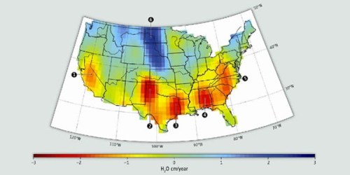
In the high plains, the sequence of dams, diversions, reservoirs, and projects of irrigation were built to ensure, facilitate and increase the local availability of water have been rationalized by expansive understandings what constituted “beneficial use” and the ownership of water rights–and plagued by federal adjudication of ways of providing energy to accommodate its increasing over-development. The construction of a map the proposed to protest the effects of lack of local management of water has received increased attention as a record of “what might have been”–and indeed a record of how we might shift our attention to place in relation to how regional watersheds defined water’s availability–and what access to water might look like.
10. To be sure, multiple misconceptions of space have under-written the historical expansion of farming. Questions about managing land water directed renewed attention to how Powell, one-armed explorer of western states communicated the need for constraints on water-use across the west. Powell had hoped to represent needs for preserving local control over watersheds across the “Arid Region” in 1880, relying on his familiarity with how steep ranges, ridges and cliffs framed thin streams of river water in the region to which he was especially attached, and to work out a better relation to place and region within the bold colors of his elegant map. Indeed, Powell’s concerns for water management gained the attention he so hoped and desired, but also create a monument of cartographical ethics to which current maps of drought might aspire. For unlike the broad drainage basin of the Mississippi that collects water which had nourished the expanse of American agriculture of 3.2 million square kilometers–
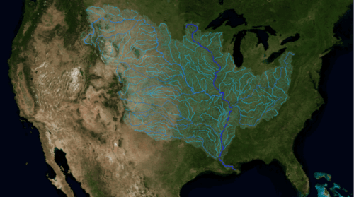
–returned to the need to accommodate water to prospective inhabitants of the Arid Region clear to Powell by circa 1880, at the height of his leadership of the USGS, based on local knowledge of the limits of water supply in the region. Powell hence reorganized the spaces of water management. Today, his map serves to caution agains projects of diversion and the national administration of groundwater, by preserving the integrity of drainage districts in any viable future plans for the settlement of the west. While we cannot but view the map as a foresaken approach to conservation, and through data visualizations of the increasingly declining water table of the region, Powell hoped it would re-orient viewers to the unique questions of water management the region that Powell well knew would increasingly face in our currently over-irrigated nation.
The map deserves to be closely observed again, and its delicate web of riverine networks in its so distinctly colored drainage basins.
 John Wesley Powell, “Arid Region of the United States–Showing Draining Districts” (1880); courtesy Ramsey Associates; see Susan Schulten’s Mapping the Nation blog
Looking at the lovingly rendered map that discriminates drainage districts across the region, we almost forget its aridity, our attention called to its rivers and their watersheds. We immediately realize that the hope to accommodate the low availability of water across the 100th meridian predates the drought, but is a result of lowering the water table across the west. Even if a rise in air temperatures of 2ºC would increase water scarcity in a region below the standard twenty inches of annual precipitation, the map cannot be seen in the light of the distinct vulnerability to or risks of ‘drought’ in the country–
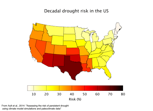
–but echoes the distribution of rainfall in recent years:
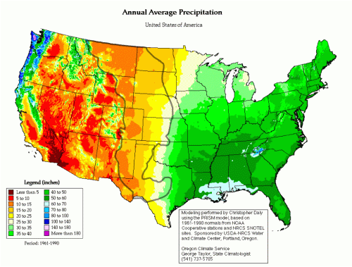
–and, even more strikingly, the expansion of irrigated farmlands beyond 55 million irrigated acres of farmlands, using upwards of 88.5 million acre feet of water in 2013. Indeed, with more acres of farmland irrigated by sprinkler systems than gravity, the artificially induced redistribution of water by irrigation systems raises key questions about the collective stewardship of water resources, and a dramatic expansion of irrigated acreage dedicated to horticulture–and a massive expenditure in 2013 of $2.6 billion on irrigation equipment, facilities, land improvements and computer technology. The percentages of irrigated cropland out of all harvested croplands in the United States show a picture of radically disproportionate irrigation–

–and a level of irrigation that outweighs acreage of fertilization:

11. The incessant irrigation of some 6.1% of all farmlands in the USA suggests a widespread mis-use of water resources that Powell would have been tortured by as a mismanagement that could have easily been avoided if his own map could have effectively reached the legislators he so desired to convince. While this very region is not appreciating in value, and not high-value, the continued irrigation of the region may cost the country in the long run. The impact of Powell’s remapping of the drainage districts of the Arid Region as regions of water governance has no doubt grown with the exposure to an increasing array of data visualizations to orient us to interventions in ground water supplies. Powell sought to restrain development of the very projects that would rewrite the history of water across the American West, seeking to curtail the federal control of rivers, water projects, and irrigation by describing consequences of settlement and water management in western lands that have blossomed over the past century and a half, producing an untold expansion of dams, projects of water diversion, and reservoirs.
 Major Dams in the American West/National Map
The expansion of freshwater rights has so expanded in western states to prompt pressing questions of the sustainability and ethics of waters across the region, as well as a dramatic rise in data maps designed to reckon with the effects of expanded local use of water in the very same “arid region” Powell described.
 Freshwater Use in western United States (2015)/USGS
But Powell’s map is perhaps best viewed not only against the screen of such data visualization of drought of recent years–

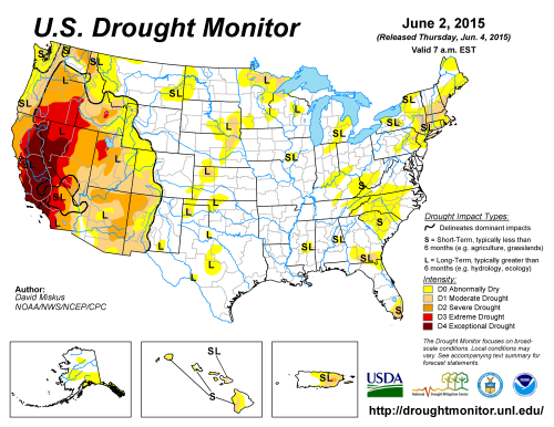
–or the disaster of farmlands in the Dust Bowl, whose epicenter lay along the meridian, and whose region Powell’s map effectively described–
–but also against the range of contemporary landscapes that painted inviting panorama of the dramatic landscape of canyons, ridges, plateaux, ridges, gorges, at times with thin streams of water that ran through them, and the need for locally administering areas whose water was both thin, but whose resources demanded a new mind-set to be worked around. Powell’s 1880 map presented a radical proposal for local control to limit water use, and preserve the landscape he loved. Powell’s proposal won little public attention for fifty years, despite his persistence in trying to orient the nation to the benefits of local control over watersheds of western rivers, it is now celebrated as particularly providential in its refusal to give such latitude to the concept granting the preeminence of locally administered “water rights” rather than leaving water subject by national agencies that, despite increased interest in sustainable agriculture, seem deeply unsustainable. The increased drying up of the local landscape and indeed of the increased drying out public lands in just the previous fifteen to twenty years.

Powell communicated the dangers of the diminished presence of water in a populated Arid Region. He did so from his own deep familiarity with waterways and ravines he extensively navigated from the late 1860s, which led him to advocate importance in considering the specific nature of land-use as the nation during western expansion and the better management of open western lands. The uneven distribution of water, mapped in the National Statistical Census, cut across the grain of the images of abundance that were already documented in a range of panoramic landscapes and atlases, as well as the elegantly colored oil paintings and Great Surveys by Thomas Moran of Colorado, Yellowstone, and Yosemite. The imposing open landscapes they revealed in the 1860s and 1870s in publications as Scribners, and the expedition updates that ran in such popular publications as The Atlantic Monthly and Harper’s Illustrated, would have provided the basis for much of the public’s orientation to the same region that Powell sought to counter-balance by a more exact assessment of its environmental constraints and the limited use of water available in the region–an assessment he thought would tamper the eagerness of unfettered westward expansion.
12. The image of abundance was not only widely known, but served as basis for promoting a new attitude to the western lands. Many of Moran’s paintings were reproduced as engravings in venues–if without his open endorsement–tacitly encouraging and promoting the construction of the Pacific Railroads and other operations, and as inviting landscapes. And in strong contrast to the claims Moran’s landscapes made on viewers, Powell’s map presents a distinctly different rendering of the management of the extreme scarcity of water in the same lands, orienting viewers to a landscape removed from purely aesthetic value, and a far more utilitarian use of color–if Powell’s map adopted its own striking color scheme to render the separate drainage basins by which he argued any prospect of the future development of the western states might be considered its counterpart. In expansive landscape paintings, Moran presented a model of the physical wilderness that became an image of geographic bounty and plenty particularly popular, known for luring visitors to its lush beauty, was long been taken as motivating a changed ecological relation to the western lands that expanded its lush bounty and abundance–

Thomas Moran, Green River of Wyoming (1878)
–and a compelling aesthetic image of open prospects of opulent bounty, reflecting the expansiveness of Big Sky Country–
 Thomas Moran, Green River Cliffs, Wyoming (National Gallery of Arts)
 Thomas Moran, Nearing Camp on the Upper Colorado River (Bolton Museum and Library)
The opulence of the western were presented as an untouched land by painters such as Alfred Bierstadt, who similarly used oils to create a sense of its virgin land veiled in fog–
 Hetch Hetchy Valley in nineteenth century/California Historical Society
–or with a natural majesty replete with water, and as an unsettled New Eden.
The gauzy palette that oils enabled encouraged Bierstadt to create a luxuriously chromatic atmospheric sense of light and lush if uninhabited wilderness:
In contrast, Powell used a sparse cartographical palette of primary colors to orient viewers from natural majesty to a presented a more austere vision of the limits of water-use, based on a rigorous determination of topographical and hydrological constraints. His own elegantly colored map of the Arid Region was less compelling or aesthetically impressive as a landscape, less rooted in an aesthetics of abundance than in detailed knowledge of water-flow, increased aridity of the regional landscape, and how such challenges might be best and most appropriately responded to. His vision of scarcity was in a way particularly un-American, however, and perhaps not congruent with the vision of the nation that the late nineteenth century real estate market sought to promote.
13. Place seems increasingly unclear in much of the current west, and the integrity of place challenged in an age of globalization. In many ways, Powell’s map offers a salutary reclaiming of place and of the preservation of water rights that suggests a distinctly melancholy relation to water rights. Powell preserved a sense of place that was not only deeply personal, based on first-hand voyages down each river from the Green to Colorado, but sought to orient the nation to what lay beyond the hundredth meridian–traveling with a large team of cartographers in hopes to best embody a picture specific to the region’s unique character to the nation in ways that make the map a monument of ecological cartography, especially sensitive to registering pressing questions, not then and perhaps still not adequately understood, about the relation between water and land. There is a distinct note of melancholy in the crisp but natural color palette–ochre; tan; light green; dark green; baby blue; brown–which Powell layered on a hydrographic map to make an elegant point about the dangers of water-use and the potential for mismanagement.
Powell’s map reoriented views to the majestic landscapes and panoramic engravings of Moran and contemporaries by trying to force viewers to attend more closely to the detailed rendering of waterways within its purview, to raise questions of the possibility for the best maintenance of its lands. Powell’s deeply national project sought to project the best form of land-management–comprehending the reservations of the Navajo, Hualpas, Noqui, and other native tribes, whose lands are notably farther removed from freshwater and watersheds, in far less desirable lands. The appeal to the value of land management and the benefits of national and not local oversight over water use is explicitly as much as implicitly raised n the map. Its bright colors call attention to the importance of separating administration of the particularly delicate economy of water in these national lands, and the varied presence of water in different lands, providing a way to read each region in relation to the river that might irrigate settled territories.

The distinct properties of the land became a way to wrestle with the question of water scarcity that occupied the chief public concerns about the region. Powell’s map in a sense also wrestled with the question of how in habitants might settle in an emerging region of the nation where little security was provided by insurers and little money lent by independent financial agencies. Before being named to direct the USGS in 1881, Powell widely advocated remapping the administration of water-rights to ensure the integrity of each western watershed–though his detailed maps convinced few. In an attempt to direct attention to the need to supervise water usage on a local level to preserve the region from agriculture land-use, Powell used the results of a wide range of data in the recent Statistical Atlas of the nation to create a convincing multi-color portrait of the Arid Region beyond the 100ºW that incorporated few datasets, but sought to orient readers to the primacy of water-rights in a region increasingly regarded as open for settlement.
Powell devised his map in order to persuade legislators of the need for restraint in declaring water rights in a region whose particular geography he sought to introduce better to the nation, and in so doing created a beautiful icon of environmental stewardship which, without citing statistics–let implicit in the map. Retrospectively, Powell’s organization of regional space to enclose watersheds echoes a narrative of accommodating to increased water scarcity. How Powell sought to suggest the need to organize its space in ethical ways has gained new impact in the age of web-based maps of water-levels, however, as a road not taken in the organization of water rights in the American West. Powell sought to modulate the unqualified encouragement the Homestead Act gave settlers to Go West across, by devising a map that attended to place in a region he didn’t need to remind readers was distinguished by low rainfall as sites of water management, by orienting readers to the need to center regional authority beyond the meridian along watersheds–instead of separating watersheds along state-lines.
The elegant autonomy of each watershed’s tracery, held in the varied intensity of bright colors, sketched a holistic relation to the land by which Powell did his best to preserve each river’s name–from the Columbia to the Snake to the Missouri to the Colorado, as if to return the states’ names to the land, and surround them with the multiple reservations of native American Klamath, Navajo, Blackfeet, River Crow, Moqui, and Crow, dividing states like Idaho, Montana Wyoming, Colorado, New Mexico, Arizona, and Southern California into regions that held and cradled unified traceries of watersheds within them.
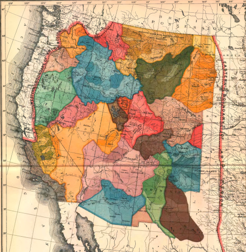
The configuration foregrounds a delicate web of rivers across the region in an area blanched of most human settlement save reservations–as the Navajo and Noqui below, striking to modern eyes, suggests the arrival of new regions to the federal administration and its selectivity focusses less on ruled parallels and meridians to define the stark landscape than preserving pathways of water to foreground the question of water scarcity.
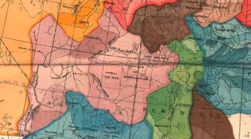
Powell’s map has been recently rediscovered as an elegant response to terrifying problems of living in western lands with low-groundwater levels, where poor practices of water-use have led to an unprecedented increase in the depletion of aquifers. Powell believed deeply in the need to restore local levels of administration, which he did by an early form of layers, in a need to obviate the eventuality of a need for a national plan for diverting water for irrigation which later led to the search for new water sources that have continued to lower the water table of regional aquifers, as well as groundwater. Today, one can detect the depletion of aquifers across many of the same arid regions, so extensively have water rights grown on the illusion of infinite supplies of water that farmers resort to increased extraction of groundwater, resulting in unheard of depletion in regional aquifers–
 Depletion of Groundwater Aquifers, 1900-2008
–and indeed an alarming rapidly decreasing water levels across the western states as well as so much of the nation, as measured by MODIS satellite over the past decades–
 USA Today/Desert Sun analysis of USGS data, 2000-2015
For much as Powell had so feared, we are increasingly confronted the potential result of increased conflicts over water “rights” in western states to meet growing water needs.
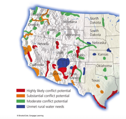
The most evident effects of the decline of groundwater in many regions of the American west appears in correspondences with the spate of wildfires raging in much of Arizona and California, as well as Kansas, Nevada, and Idaho, as currently compiled by USGS:
14. Few maps attend to the haphazard claims of water ownership, but Powell’s submitted exactly such a map to the US Dept. of Interior, to suggest the benefits of making western states conform to the circulation of water and claims to water rights, redrawing their boundary lines around their respective watersheds, rather than existing state lines drawn along latitudes and longitudes, in ways that digest data about the nation newly available in the Statistical Atlas by embodying its expanse in new ways, and by confronting the problem of uneven distribution of rainfall that it raised through a new division of space. Powell had especially depended for his own map of the Arid Region on the cartographical tabulation of rainfall Chas. A. Schott contributed, using rain gauge studies, constituted a foundation for confronting the unique problems settlement of the nation’s Arid Region faced.

 Chas. Schott, Rain Chart for the United States (1872) Library of Congress
If Schott’s detailed Rain Map offered a basis to understand the west, it suggested tensions between dividing space by state lines, railroad routes or rivers and the need to reconcile multiple courses across the nation’s growing expanse:

Today, the scarcity of water in the same region would give alarming importance to the lack of a system of water allocation for quite different reasons, but it raises even more sharply some of the same problems of what constitutes reasonable water-use in the same general area that Powell had defined–and raises questions about how Powell ascertained at least 20″ of wanter to fall in any area where agriculture remained a viable alternative, and it made sense to dedicate water to irrigation based on pre-existing water claims:
 1961-1990 normals from NOAA and NRCS SNOTEL sites using the PRISM
But the organization of data were far less readily able to be exactly achieved in an age where weather was less easily departed from the ground–and indeed from the distance hydrography of regions and relation to the working of the soil. There were many limits of closely surveyed land to which settlers were sent was evident in the national topographic survey of 1888, which encouraged the western expanse to be seen by their division by parallel and meridians–much of the drier region was not even surveyed by the USGS.

A significant amount of territory comprised Native American “reservations”, although the magnification in Powell’s map of “Navajo Lands” may have seemed considerable.

15. But the most telling sort of re-writing of a relation to space was by suggesting new bodies for the administration of water needs. Powell’s revisionary map re-imagined the region beyond the 100°W meridian–long considered a barrier to agricultural productivity, and the frontier of farmlands as well as national divide of levels of rainfall–by attempting configuring the “arid land” High Plains less as the “eastern edge” of the American Desert, than a new region of water management. The divide beyond which insurance companies would not travel was shown as a region whose environmental health might be preserved.
Powell’s map has gained a second life in media and online as a “new map of the west,” since the allure of its preservation of the integrity of watersheds, rather than states’ lines of jurisdiction, has given new immediacy to the 1890 map as a road not taken in the division of the west into drainage districts and an alternative model for water’s administration. The retrospective attention to Powell’s re-imagining of the area west of the hundredth meridian, as if it advocated brining the regions into the union as bounded watersheds, and not defined by parallels and meridians.
The appeal of the map in light of massive mismanagement of water uses and rights across the American west comes as we began collectively to take stock of the issues of water scarcity–and he issues of water ownership that may lead states to confront one another in water wars which might have been forestalled by recognition of their ‘natural’ water limits that Powell so clearly proposed, or by enshrining these ‘natural’ limits in the form of a new land-map of the American Desert beyond the hundredth meridian. The notion that the scarcity of water might be more effectively distributed was a hard sell, but one to which Powell devoted considerable effort out of a belief that this was a more practical and more ethical way to ensure the local governance of water rights.
John Wesley Powell, “Arid Region of the United States” (1890)
The appeal of the map as a road not taken, and an alternate and more responsible way to imagine our relation to the land, has provided a more sensible model of ecological stewardship–even if it came from a period before hydrology was much understood.
 John Lavey, Sonoran Institute (2013)
In the midst of another electoral season, John Lavey’s redrawing of states’ boundaries offers a salutary strangeness of regions by which data visualizations overwhelm us. But it also invite us to ask what sort of integrity a state enjoys after all as a political unit, and what the boundaries of states might be alternately configured, drawn around the watersheds of rivers–rather than along lines of longitude and latitude. Lavey’s attention to conforming to watersheds, along Powell’s model, rather than rectilinear abstractions of latitude and longitude, to determine inter-state frontiers.
16. While Powell’s radical notion of defining states by where they derive their water from seems an oddly nativist perspective, in an age of international cash-flows, the attention it returns to physical geography focussed on the allocation of resources not only west of the hundredth meridian Powell sought to discuss, but the preservation of drainage basins across the country, even if preserving intact watersheds would extend the nation beyond its current boundaries: Michigan in this map comes to encompass all the Great Lakes; Florida extends into the aches of the and lower Georgia; Utah loses its perfectly rectilinear edges; California’s boundaries wriggle over the Sierras to comprehend the Colorado river, and Texas, New Mexico, and Louisiana gain new forms–as Arizona and New Mexico now straddle the border with Mexico, to preserve its intact local watersheds, whose integrity here trumps familiar meridians and border lines.
Powell’s map appeals because it resonates so sharply with our symbolic map of the western United States. If apparently perverse redrawing of states boundaries is not intended to create a reallocation of electoral votes–although it surely would–or offer distributions of population to foster an equitable tax-franchise, it seeks to question the best ways of distributing regulation of water scarcity in a delicate landscape. Powell’s map was taken as a salutary revisiting of the country by the Sonoran Institute, aand led John Lavey to emulate Powell in remapping the entire nation by watersheds and rivers. In offering a new way to imagine states as individual watersheds, creating intact watersheds that lines of longitude and latitude distort, to secure proper maintenance and security of water rights, Lavey’s map jars the viewer used to familiar data visitations that have distorted the value of states’ electorate votes, spending on healthcare, or population. Lavey’s map may extend a far more cogent argument to modern eyes, but Powell’s is a forceful argument for organizing an ultimately more equitable distribution of water, designed specifically to prevent states disputing water rights–and advocate a more flexible prototype of the communitarian settlement of water disputes west of the hundredth meridian, where the transition to o boundary line of the “Arid Region” begins.
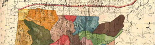
The map Powell submitted to the US Congress revised the boundaries of western states to forestall a particularly problematic allocation of water rights in the future followed the boundaries individual watersheds, and address questions of water usage in a region of water scarcity far better suited than the abstractly ruled border-lines by which states’ governments were determined: as all water should be locally governed, rather than federally allocated, he argued that only by preserving the integrity of a river’s watershed could the reconfiguring of the West reduce the eventual contestation of individual water-rights beyond the 100th meridian.
“To the arid region of the West thousands of people are annually repairing,” he had concluded, “questions relating to the administration of these lands are of present importance.” After detailed first-hand observation and exploration of its topography and hydrography by canoe, Powell concluded that rather than follow the latitudinal lines that Jefferson had proscribed, the Boundary of Arid Regions nestled between the Sierras and the public lands of the prairie, and straddling the Continental Divide, would be best preserved as a wet region endowed with its own independently derived water supplies. While he discussed the Arid Region of the Rocky Mountains and the state of Utah in early reports, he mapped in broad brushstrokes the Arid Region as excluding much of far moister region of Northern California, but extending from the Sierras to the curving of the Upper Missouri and to the end of the North Platte, imagining the nation by drainage basins. (Northern California, in this geographic imagining of the nation, was less likely to engage in traffic of water with Southern California, or anything south of the orchards of San Jose, as it is excluded from the Arid Region by a border-line Powell’s brightly colored map invites us to entertain.)
Indeed, the Arid Region is strikingly without any cities, and seems a blank canvas on which the division of states as individual drainage basins was possible without any conflict of municipal or governmental claims; while the boundary lines of some states are noted, rather than follow latitude and longitude lines, as if superseding them, the coloration of discrete drainage basins constructs a natural and practical division of land as necessitated by the distinct meteorological conditions of the “Arid Region” and the care that should be taken in preserving their integrity.
 John Wesley Powell, “Arid Region of the United States” (1890)
Powell’s initial Report on the Lands of the Arid Region of the United States focussed on Utah. The first five thousand printed in March 1879 seemed insufficient to meet demand; a second edition was revised for July publication. The survey that revised the open-ended promotion of homesteading later resulted in an even more revisionary map that Powell created to propose the reorganization of the entire west along lines of land conservation of a region, whose agricultural development depended on irrigation, since its land did not otherwise receive moisture needed to nourish crops. The few regions that are irrigable lie along its streams; while his study of Utah distinguished its irrigable lands, his subsequent map of the expanded Arid Region suggested the need to preserve the integrity of watersheds for future effective administration of the lands by a system of local canals that responded to local water needs.
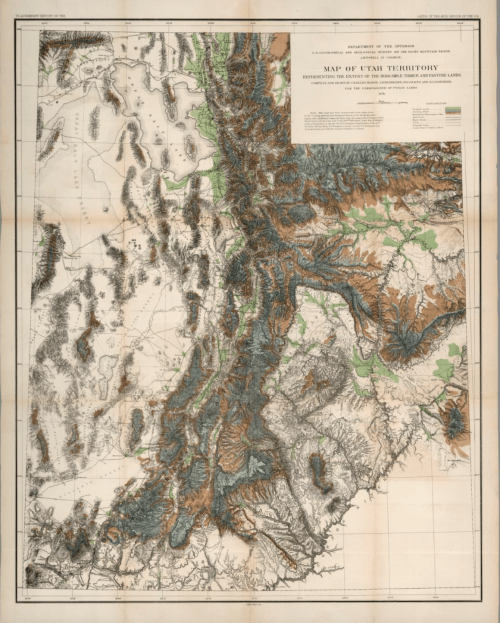
John Wesley Powell, Map of the Utah territory; representing the extent of irrigable, timber and pasture lands (1:630,000) (Cartographers Mahon et al., 1878)
Across the Arid Region as a whole, Powell argued, “the area of irrigable land is limited by the extent to which water can be used with proper engineering skill, and the extent to which the discharge of river-water may be used to irrigate lands.” As he divided Utah by the drainage areas of the Colorado and Desert, drainage areas provided the best means, Powell argued in his 1890 map, to understand the organization of the Arid Region by drainage areas, addressing the dangers of allowing homesteading to spread throughout the region and using large-scale dams coordinated by the federal government to define the west.
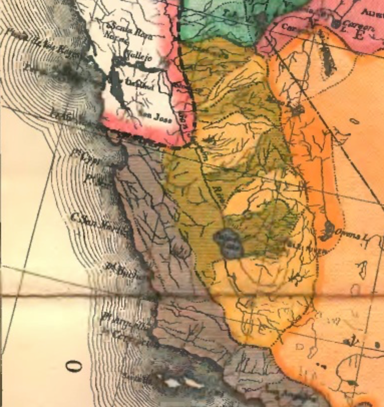
Powell’s aimed to create an overall image of the extensive Arid Region, comprehending an area dominated by Indian Reservations, by bounding a region that was seen as less valuable or, perhaps, even open to settlement and administration: the territory included the Reservations of the Crow, Pine Ridge, Navajo, Mikta, and Moqui, along the Colorado River and the border, such as it was, with Mexico, demanded a detailed level of attention to local conditions that speculators did not fully understand:
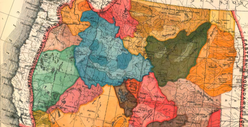

Powell had devoted increased attention to native American inhabitants of the region both as an ethnographer–detailing artifacts and manners of habitation–as well as local customs of water use, in ways that must have attuned him to the relation of prospective settlers to the land, as would have his study of the contemporary comparative geography of George Perkins Marsh, Man and Nature: or, Physical Geography as Modified by Human Action which provided a standard for understanding cultural practices of the land management.
 Powell and the Paiute Indian Tau-Gu (1871-2)
Drainage districts defined the land. Of course, in that century, a far greater number of wetlands existed across the country, which was considerably wetter and less engineered to agricultural development than it was to become by the later nineteenth century, and especially during the expansion of arable lands across the country during the WPA.

In 1873, the watersheds, lakes, and river systems in California’s San Joaquin, Sacramento and Tulare Valleys suggest a remarkably self-sufficient system of water transport, including a freshwater lake far larger than Lake Tahoe in the Southlands–Lake Tulare–and a rich system of wetlands that stretches down the state’s Central Valley, long a center of agriculture but more recently a center of agribusiness to which the waters of the Sierra are channeled, in ways to compensate with the former fertility of the San Joaquin, Sacramento, and Tulare Valleys that have been so re-engineered to be rendered unrecognizable, by a combination of drainage, land reclamation, and dams, and the Colorado River to be redefined by the Hoover Dam.
 Board of Commissioners on Irrigation, California – David Rumsey Map Collection

Geographer Matt Clark, who lives in the Central Valley, constructed a fantasy satellite map of the entire state as it looked in 1850, showing the rich riparian environment of the Central Valley, with the now-dry Tulare Lake nourishing a region whose surface area ran some 1,780 square kilometers–fed by rain as well as the massive snowpack over the Sierras that nourished a state more green than in most any satellite map seen in recent years.
 Matt Clark
In the spirit of this map, it makes sense to note the reduction of much of the wetlands within the state from the 1780s to the 1980s, a huge time space in which California suffered a massive loss of wetlands–more than 95% of what it once possessed.

The separation of the great coastal rivers that enter the Pacific may suggest their more settled nature, but reflects their greater nourishment by this heavy snowpack. The degree to which this landscape had departed California was not so evident to the geologist and anthropologist Powell, an early director of the United States Geographical Survey, who served in the office after making many expeditions on canoe across the west, from the Green River to the Colorado River to the Grand Canyon, all the time in extreme pain from the loss of use of his right arm in the Battle of Shiloh, while leading the charge of a battalion of light artillery.
17. In his 1890 map, Powell made the case that the “Arid Region” of the United States by organized by preserving (and indeed asserting) the integrity of its watersheds, in ways that recall the Hydrologic Unit Codes–HUC’s–and proposed a model for conceiving the West not in terms of “public lands” that could be claimed by settlement, but in accordance with what he considered their most useful division into their respective sources of drinking water–promoting a vision of the sustainability of the west, rather than converting it to farmland to be fed by federal projects of the reapportionment of water sources. A similar point advanced in Powell’s 1878 Map of the Utah Territory for the Department of the Interior, specifying the limited land available for irrigation and agriculture, or for animal pasture, as if to discourage its development:

Guaranteeing theist democratic practices of potential land development was the sub-text of Powell’s more detailed multicolored map of the US West, which was even more polemical in its intent and its hopes to persuade readers to realize the needs to consider a more practical way of dividing space that would allow sustainable, regional water infrastructures that would remain supervised by local–rather than federal–control.

Powell’s tacit defense of the bounding the integrity of natural watersheds recalled other watershed maps united basins as of the Mississippi, Alabama Rivers, St. Lawrence or Del Norte, although such thematic maps were not proposals to shift lines of jurisdiction. However, the ecological ethics of Powell’s map–if they were less explicit than what he saw as its superior practical efficiency–was in fact submitted to Congress in an attempt to stop the effects of the Homestead Act in the partitioning of land ownership, employing hydrographic data and drawing on the mapped experiences of both Mormon colonizers in Utah and the Mexican community-based management of water, community run conduits carrying water to agrarian lands used by farmers in northern New Mexico and the Upper Rio Grande in south central Colorado.
The drawing of state boundaries by dotted lines around watershed boundaries was a means of better integrating and situating residents who settled arid areas of the American West. The division of states was a far-fetched a proposal. Part of the not-so-hidden argument for better understanding how state-lines were to be drawn in the so-called Arid Region, not in fact that well-known by most Americans, was the growth of a variety of new ways to embody the nation, distribution of rainfall in the nation tabulated in the Statistical Atlas of the United States (1870), which for the first time embodied the nation’s physical features and divisions of population in order better to comprehend its coherence, including its river systems, that provided a new model for dividing regional systems by rational criteria:
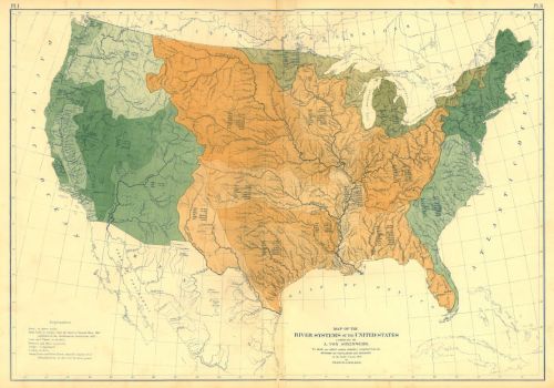
The publication of the Statistical Atlas met a need to embody space in new ways by the huge and unprecedented data drop it offered of the distribution of physical geography and populations. The map of river systems responded to this need openly, for example, and created a new division of space based on tabulating each region by relative population, space, and rainfall, in ways that proposed a set of tools to better understand its administrative division:
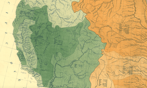
Powell had especially depended for his own map of the Arid Region on the cartographical tabulation of rainfall that Charles A. Schott had contributed to the Atlas, using rain gauge studies provided by the Smithsonian, which constituted a basic foundation for defining the unique problems of settling the nation’s Arid Region–
–and provided a basis for envisioning and understanding unique nature of land settlement in the west, indeed providing a comparison that suggested the tension between dividing space between state lines, railroad routes and rivers:
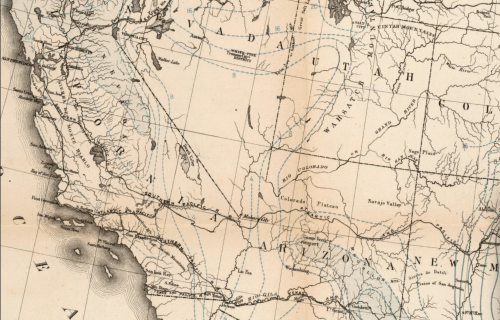
18. Powell’s color-enhanced cartographical argument exploited a refined hydrographic dataset of watersheds, condensing detail by selecting watershed to make his point eloquently and directly. Even if the crucial role of water rights was rejected by the Congressional committee, who wanted to hew to Jefferson’s ideal, Powell’s extensive expeditions and travel created both a clarity and an apparent urgency for framing a strikingly beautiful proposal that watersheds be the basis of statehood and state jurisdictions, that countered the quite haphazard assignment and declaration of water-rights settlers could make on a local level by public announcement: “Gentlemen,” Powell strongly cautioned audiences in 1883 against not attending to water scarcity across individual watersheds in the west by warning, “you are piling up a heritage of conflict and litigation over water rights, for there is not sufficient water to supply the land“–and he saw the potential disaster of returning all disputes of water-rights to Washington, which would be forced to adjudicate contested claims on water to irrigate the land.
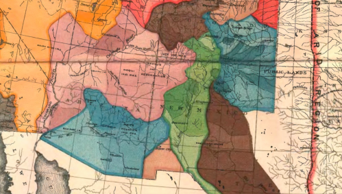
The watersheds of the rivers offered the logic for the construction of each region, as oddly irregular as they might be, in ways that almost offered a free-wheeling, if ostensibly organic, notion of boundary lines that seemed super-imposed across existing regions:

Powell’s mapping of the Colorado River was revealed his deep personal conviction of the importance of maintaining the integrity of a body of water that he knew quite well and had drafted extensively as an artist, and whose dependence on a snowpack and the delivery of water to its inhabitants he understood as the central problem of civil society in the region to which a cartographer might usefully attend. If his maps are landscapes, and all maps a form of landscape representation, illustrations of Powell’s 1875 Canyons of the Colorado capture and preserve a distinct a sense of place based on his exploration of the River and Grand Canyon; its close-ups and prospective views reveal stratigraphy and water scarcity on the river, and the homes of those who lived along it, reveal a landscape that substantiates his convictions to amalgamate regions in accordance with water needs.
Republished at the end of his life in 1895, the summation of his geographical surveys and ethnography offer a monument to convictions of land preservation and conservation. Illustrating the low water-table and level of rivers and their limited derivation from ice packs was something of a them among the lithographs of the 1895 edition, where the course of the river is something of an understated if recurring presence in his stupendous images of the Western landscape.
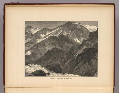 Snow-Clad Mountains of the [Colorado] River/Rumsey Associates
John Wesley Powell knew well the land which he mapped, and the settling of it by inhabitants, in ways that folks who navigate the same land today could rarely possess. And his advocacy of the redrawing of maps outside the random conventions of lines of latitude that distinguish how the map of the western states was to be drawn after the Homestead Act–

\

clearly seems to have been intended to preserve a sense of place that he perceived the map of the west was being drawn without sufficient acknowledgement. As an artist, Powell had rendered not only the stratigraphy but the forests of the west captured the distinctly arid nature of its plateau, and saw his job of providing an account of the western states to Congress in ways that best served the future administration of its open lands, and was a sort of final testament to his long career as land surveyor at USGS, and condensed an image of the landscape that he sought to communicate, if not bequeath to the nation, as well as an image that raises what seem implicit questions of the fate of water in the west.
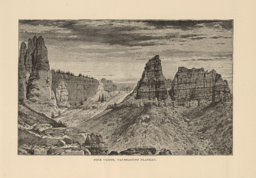 Pink Cliffs, Paussagunt Plateau (Utah)/Rumsey Associates
 Marble Canyon/Rumsey Associates
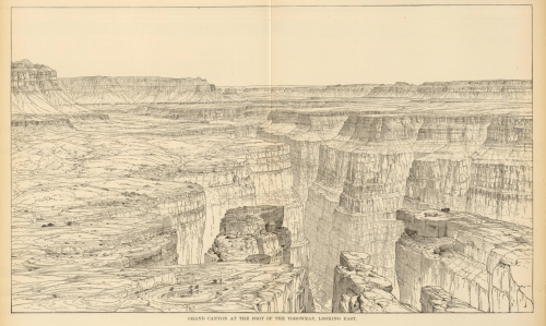 Grand Canyon, Looking East (Colorad0)/Rumsey Associates
19. Powell the surveyor tried his best to communicate this deep personal knowledge of the rivers’ watersheds in a region whose aridity he had already been able to perceive as a major constraint against its future development. Long before hundreds of dams for hydroelectric power and irrigation along the river disturbed the ecosystem of the Colorado River, Aldo Leopold himself waxed idyllically about how, while canoeing in the Gulf of California and Sea of Cortez around the mount of the Colorado, he encountered a region so diverse in wildlife–with egrets, cormorants, skittering mullets, mallards, pigeons and coyote, as well as jaguar–and a wilderness of green lagoons at its delta, where the Colorado was both “nowhere and everywhere, containing hundreds of green lagoons” near its Delta, as if it “had lain forgotten since Hernando de Alarcón landed there in 1540.” The sense of Powell’s map as a road not taken is intensified in the lithographs of the Colorado’s original paths, before it was diverted and damned.

 Mount Moran, Wyoming/Rumsey Associates
The six hues Powell used in the map illustrated his rather ingenious proposal to devise a compelling alternate vision of the nation’s watersheds of the Arid Region–a name that has of course become all the more true today than it was in Powell’s day–to respect these boundaries and integrity of individual rivers’ watersheds as discrete units, even if their shapes were likely to appear particularly odd. But rather than see the map only as a “road not taken,” which it probably wasn’t, anyway, Powell’s map raises the question of how much it was, as much as current maps of the United States that employed lines of latitudes as a far cartographical fantasy far more abstracted from the land–if the ruled boundaries of western states in the great plains symbolically suggest an austere and rigorously spare relation to nature, and to the natural topographic boundaries of individual states.
The map probably proposed just the sort of top-down legislation of state lines and land management that the congressional committee could not accept–not least because it ran against the railroads, but because it would have demanded a huge team of surveyors to enact and reproduce, and a far more difficult set of state boundaries to understand on the ground: the alternative organization of the Arid Region of the United States was pragmatic, but without the basic guidelines of latitude and longitude, suggested a crazy quilt of elegant curves that, while born out of careful surveying on the map, was far more difficult and demanding to translate into practice, however acutely it recognized the importance of adjudicating water rights, and respectful it was of water rights–and no doubt of the role that cartographers were to play in helping to adjudicate and preserve these rights.
Powell’s assertion of the need for local control and management was not met well either by prospectors, or by congressional committees in Washington. In imagining the basis for states’ rights in this arid region which he tied to preserving intact watersheds, he created what he tied to persuade Congress was a more workable model for dividing newly annexed lands, with an eye to the functioning of the water boards he saw as among the principal problematic agencies of local governance–but managed for one group of residents.
And would that this alternate road be taken on the dividing of states’ frontiers, respectful of the flow of rivers through the landscape, rather than the surveying lines by which land might be divided, it might well have been that the Colorado River would not be divided by seven different states’ and made to fit their water supplies and energy commissions–or not have been drained or allowed to run dry, due to over-engineering by water-diversion.
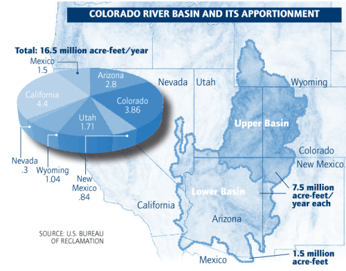
The introduction of monumental dams, aqueducts, irrigation canals and reservoirs across the 1,450 miles of a once powerful river, coursing with water from the Colorado Rocky Mountains into the Gulf of Mexico, has created te odd scenario in which most of its water is dedicated to the irrigation of an area far greater than the river alone is able to nourish in the seven states through which it runs–

–not to mention the disproportionate nature of redistributing water among them.

Today, some 40 million residents have come to depend on water from a river that has almost run dry due to mismanagement, much as the belief in the river’s inexhaustible supply of water has led to projects of anthropogenic alteration of its flow to an extent that its arid river-bed is most often hardly recognizable as one of the major rivers of the American west.
 Hoover Dam, Michael Friburg/ProPublica

If at first glance, John Wesley Powell’s map at first seems a less utopian a cartographical fantasy of the drawing of state-lines that remained in place through the later nineteenth century, which explicitly took surveyors’ lines of longitude and latitude as a basis to divide regional authority, taxation, and representation, the hope to gather entire watersheds of major rivers within a single administrative unit of governance in fact illustrated but another sort of cartographical fantasy of inscribing authority in maps, as well as a road not taken. Powell was aware, no doubt, that the division of land he proposed would run against the interests of railroads and previous land grants across the western states, to rail roads and wagon routes, which did not coincide with the rights to river water in the west.
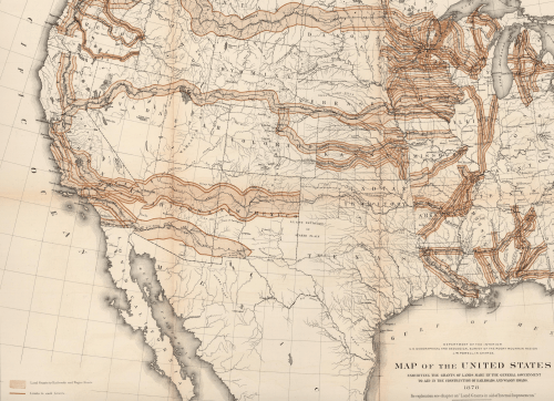 Map of the United States Exhibiting the Grants of Land Made by the General Government to aid in the Construction of Railroads and Wagon Roads (1879)/Rumsey Associates
The land grants quite conspicuously ran broadly against river systems in the Southwest:
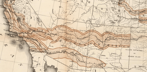 Detail of above land grants for railroad and carriage corridors/Rumsey Associates
Although its proposal of rather idiosyncratic boundaries that have been seen as preserving the ecology of place in ways that remind us of the mis-administration of lands, where water was re-routed from rivers and piped to areas designated as fit for agrarian production, the boundaries Powell proposed to redraw state lines were in a sense the utmost cartographical fantasy of drawing sovereign boundaries that perfectly coincided with natural water flows. But as the flows of people across the land, in trains and by road, overtook the flow of water–and was, on more than a symbolic level, superimposed over it–the integrity of watersheds had already become effectively overlooked.


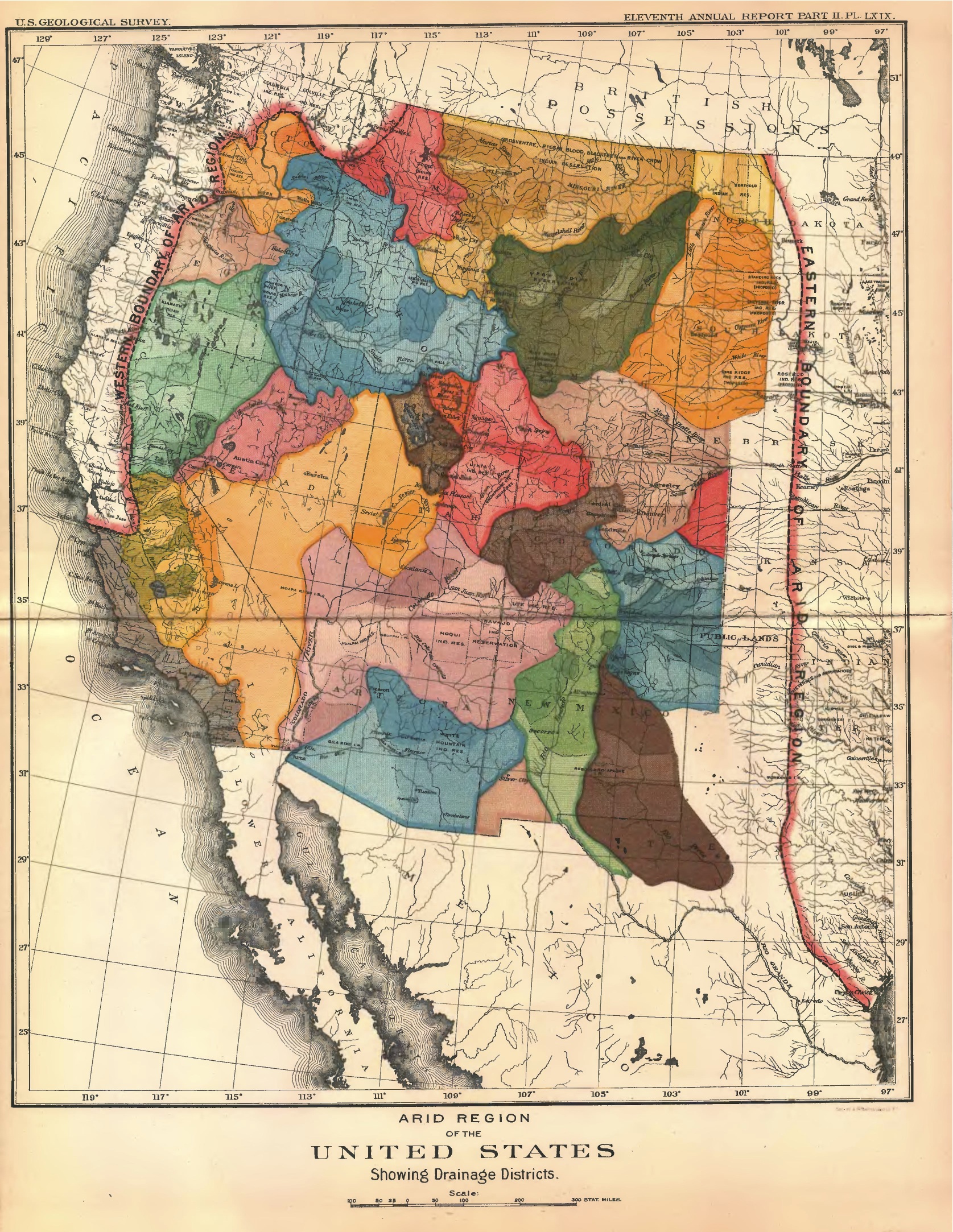
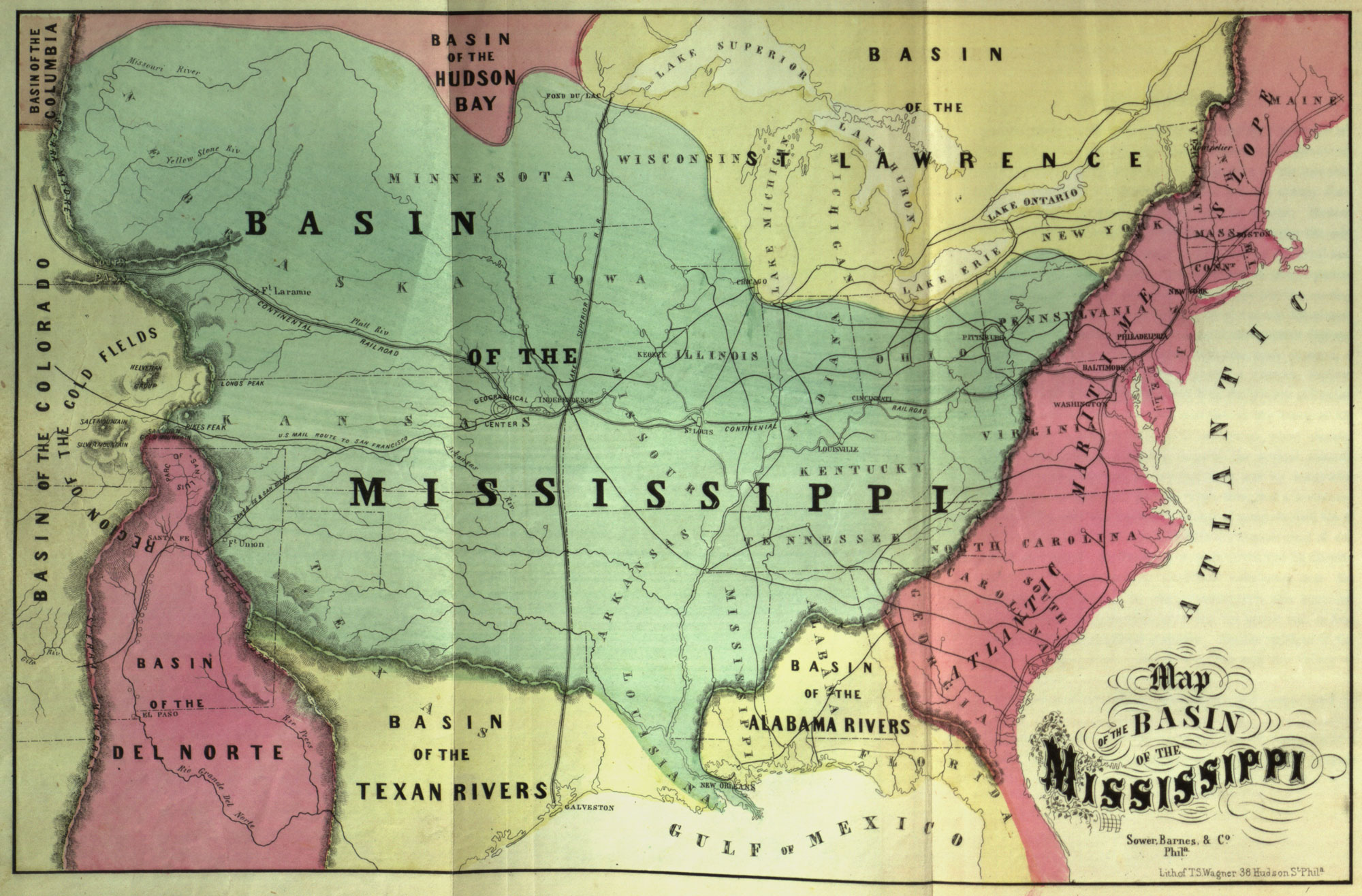
A sad sad story, for all the beautiful maps and rational perception…