
The “Rudiments of National Knowledge” engraved in 1833 from a form attributed to Joseph and James Churchman, presented itself both to “the youth of the United States” as well as “enquiring foreigners” was represented as if it embodied a dove of peace. The original 13 colonies were expanded to an eagle posed in flight, facing Europe, as if they provided a model that responded to the period of continued war of Napoleonic and post-Napoleonic Europe, and a new exemplary model of a national space: embodying the United States not as the first bird that Noah saw after the deluge, or a lasting image of peace if not a reminder of our better natures, but as a sign of liberty whose connotations weren’t lost on Churchman brothers.
In naming the “Eagle Map” as the region that extended over the Missouri Territory until Mexico, the current mid-West regions cast as the expanses of its avian wings, posed in flight, its talons filling the wild and scraggly expanses of Florida, the brown-ink tracery that seems executed on the surface of the map itself seems a far cry from the militaristic eagle of the twentieth century. Although the map was colored by its owner, the delicate feathers engraved on its surface reveal the engravers’ intention to embody the region by its avian form. Despite the statement of the intent of its authors–presumed brothers–to publish a further map to be sold by subscription, no other copies of it survive.

An image that is newly accessible to all through the DPLA, a platform that exists in purely digital form, and is in part the brainchild of Robert Darnton and a group of Harvard librarians, provides a digital archive of national memory as it’s been set up–although one might quibble whether to showcase exhibitions of the history of Fenway park (now expanded to “Boston Sports Temples“) or the Indy 500 at the same level as, say, the experience of women before 1900 or the place of African Americans in WWI, but the arrival of up to 38,000 maps and other items within the DPLA is a cause for true celebration, and not only among map freaks: the repository dignifies a critical historical resource that has been underused and too often left in the hands of antiquarians–to whom we are all now deeply indebted to having preserved. This is a magnificent opportunity, after all, to reflect collectively on what maps mean as documents, paying special attention to what sorts of arguments they present–as well as “what stories they tell.” The national atlas collection alone that Rumsey has assembled provides an inventory not only for 38,000 places you’ll never go, but 38,000 ways of looking at the world. The eagle of the United States is one of these.
Embodying the United States was a tricky proposition in 1833 because there was limited national iconography to draw upon. Instead, say, of an imperial German eagle, recuperated a familiar emblem by putting it to new use for a democratic union. Printed in Philadelphia just after 1830, and engraved for the “Rudiments of National Knowledge,” the eagle was a starting point for national self-understanding and attempt to develop interest in geography, superimposing ornithological detail on the mapped nation as if to make the observation of its contents more interesting, or draw attention to its detail.
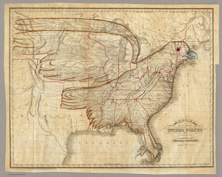
One reader seems to have drawn the shape of the bird around it, as a sort of afterthought and an embellishment, to unite the region as a coherent whole. Perhaps not much is to be made of the fact that its beak was located at Boston, or nearby, and its heart somewhere near Washington, D.C.–or its eye somewhere in Vermont. These seem somewhat happenstance or by default. The eagle was to a counter-map to the Hapsburg eagle, but also an icon of liberty, and a new symbol of national unity.
Unlike the first Tannen map of the United States, for example, also engraved in Philadelphia and in 1811, which oddly divided the coastal states from the interior by a series of striated imagined ranges of mountains,

the map presented a detailed interior hydrography, bound by the eagle’s form, and even foregrounded its natural riches, as did the book of the same title, Rudiments of Knowledge, that it seems to have accompanied of 1833, also printed by Carey & Hart. Nor did mountain ranges stretch across the inland expanse, as a “New and Correct” map for travelers of the United States, Upper and Lower Canada, the Missouri Territory, and Floridas of 1817, by Samuel Lewis whose four colored depiction of the United States set it against a considerable expanse, mapped and unmapped alike:
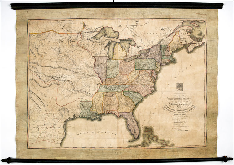
Lewis is known as one of the first enterprising commercial mappers. And while giving important details of the Lewis and Clark expedition up to the Missouri River, his large wall map took that river as a new frontier, as if to beckon readers to explore its unknown areas, even as it accorded considerable attention to the roads travelers might explore to a greater extent than earlier maps. In giving coherence to the country in the form of the bird, or of the eagle poised and about to fly, the map depicted the country as a young country, whose integrity was hardly mapped. The status of the Rudiments as a smaller map–accompanied by a book–without the temptation for readers to explore the areas “formerly Louisiana” and the mysterious mountain ranges that extend like fingers in the detailed topography extending beyond the red-lined border at the Missouri River that seem to demarcate legal bounds of the United States:

The contained country whose continuity the eagle elegantly bound encompassed all these states and turned its back on Mexico, looking out over the Atlantic with the western states confidently assumed into its form, as if to suggest a new stage in nation-building that was also one of national map-making.


