
The National Oceanic and Atmospheric Administration’s Office of Coast Survey has long issued authoritative charts of the nation’s coastal waters. But from this coming Spring, that office of the Dept. of Commerce will cease to print the lithographic charts it has long reproduced on paper in such glorious precise detail. What is billed as a major move of cost cutting no doubt reflects the dominance of electronic maps consulted on laptops or hand-held devices. But it also will place a new emphasis on reading charts on the screen media and by comparisons to GPS, using computer screens exclusively rather than in consultation with paper charts. Is the cost of charting the shifting form of coastlines worth the cost of ceasing production of revised maps?
As a response to the difficulties in reprinting up-to-date paper charts for sailors who often fail to purchase them, the Coat Survey has decided to shift only to distributing charts via on-demand printing, PDFs or electronic charts as of April 13, 2014, both to allow access to updated nautical charts, and allow access to digitized versions of the full range of coastal charts on NOAA servers. Increased use of digital and electronic charts has dramatically diminished the profitability of commissioning individual lithographic maps, marking an end of an era of American cartography in print. Yet does the close of a tradition of lithographic reproduction of maps effectively distance us from the delineation of coastal waters? How crucial was the role of lithography as a medium to translate coastal measurement and tabulation into a recognized graphic format? Or is the content of the chart so easily separable from the medium?
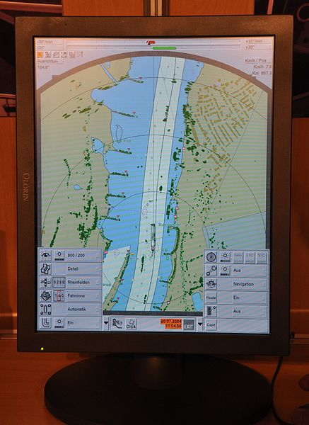
An online kerfuffle resulted from the announcement of curtailing the longstanding precedent of government-sponsored map printing in a cost-cutting move, and offering of maps only in downloadable form. The suspension of the paper lithographic charts over which NOAA long exercised a sort of monopoly–and set a standard of the accuracy of nautical cartography–is difficult to take. It seems, for one, perhaps the final extension of the dominance of online maps and mapping, and to reflect the dominance of laptops or tablets as navigational tools–something that few outside the world of practiced sailing would have imagined as a use for those media. Although there will be a guaranteed possibility of print-on-demand charts (POD’s), ceasing to print those beautifully detailed lithographs appears a victory for the digitized map-use, most often associated with the digitized format of servers like Google Maps. While not subtracting the paper map from circulation, it leaves most folks dependent on the two-inch screens of Palms, tablets, or laptops, with built-in Garmin chartplotters or other GPS systems in a sort of snazzy interface. Indeed, the shift in the circulation of maps has potential reverberations for map literacy and readership, by removing chart-reading from the sort of intense engagement such as pencil marks, course lines, erasures, or time marks that were so long the norm on paper charts.
Are the knee-jerk reservations about ending the printing of lithographic charts based, we might ask, on a romantic the fetishization of the coastal chart–those truly beautiful creations? It might as well merely register a changing threshold of map literacy. The most compelling reason is the dominance of a new sense of interface that downloaded maps allow, as well as to keep pace with the expanding number of on board on-line devices from laptops to smart phones. When GPS allows one to plot one’s global position at sea with an accuracy of within some 16 feet, the nautical chart seems to lose its accuracy. Although the reactions to NOAA’s s Office of Coast Survey has been quick and often lamented the end of the nautical lithograph, the decision to stop the production of nautical charts is not only regretted. Indeed, DuckWorks magazine has called paper charts the most dangerous thing for navigators–both in preserving a sense of incorrect measurements and obstructing access to the most up-to-date accurate cartographical information with a direct GIS interface, as another ghost of information worlds past.
Yet if downloadable charts promise an end to the problem of the inaccuracy of outdated maps, the medium also suggests a distinctly different notion of encoding data in nautical charts, now often restricted to the parameters of the medium of consultation–Tablet, handheld GPS device, or even iPhone–that seems the inevitable consequence of the shift in attitudes toward the disappearing the materiality of the nautical chart. Even if Jeff Siegle of DuckWorks powerfully centers the debate around the “chart-image” rather than the medium, in an era when it’s a truism that “the medium is the message,” doesn’t the shift to downloading digitized versions of coastal charts onto slippy screens suggest a shift in the “period eye” by which we plot expanse on maps?
As screens of laptops are increasingly the primary forms for plotting navigational routes, and the use of chartplotter products or other apps remove the physical map from its centrality as a tool of noting changes in coastline, wreckage, or debris. The consultation of paper maps is a rarity in an age of the coastal navigation by GPS, and the increasing role of on-line computers on board most ships. In contrast to the security of the information on monitors, and use of apps as much as instruments, create a new sense of how we interact with nautical space; the frequent revision of paper charts create a sense that the map may often be outdated or incorrect. Indeed the very iterability of the map–and the monthly updates that NOAA has come to release monthly probably made the choice to go online incumbent–is of a piece with the downloading of updated versions from their server. Over time, paper charts have been less often consulted in relation to screens, and offer unwieldy forms of interface. Even if the ability of reprinting of future charts from PDF’s of comparable durability is not that clear, NOAA will certify print-on-demand chart sellers; the market for paper maps has dramatically shrunk as the authority of the printed chart has eroded over time in comparison to the electronic charting tools.
The announcement to cease printing paper charts seems another page in the “end of maps”–or at least of the lithographic staples that provided a basis to note different observations, routes of travel, or changing plumb-line depths of waters. The announcement is perhaps not surprising, but suggests a conspiring of reduced funding after federal budget crises, decreased commercial demand, and the victory of the touchscreen viewer as a medium for plotting course have led to the end of unfolding a chart to read expanse, despite the huge distances regularly needed to be covered in nautical travel. Could one ever depend on a touchscreen format or the individual tiles of a slippery screen’s surface, however, as a medium that allowed one to contemplate or project a course of nautical travel with similar expansiveness? Practiced sailors lament that the map, while perhaps not a primary guide, augmented skills of orientation with “added redundancy” not only as a check, on which sailors were able to fall back, even as captains relied upon more easily updated electronic charts NOAA released on their servers. When GPS crashes or goes out, doesn’t one have the same ability of control over one’s course–and a broader framework for judging course–on a paper chart? But the medium of the printed maps faces an uphill battle in an age of GPS, when the use of dividers to plot bearings seems as rare as astronomical bearings.
Bill Griffin, general manager of Fawcett Boat Supply in Annapolis, Maryland, doubts that “any prudent mariner is going to have paper charts,” and refused to see his own line of sales of paper charts as declining: “I don’t see paper going away anytime soon.” Yet others are ready to celebrate the paper chart’s decline and say goodbye to an antiquated medium. Maine captain Jeff Siegle, who sails regularly on a coastline “strewn with the remnants of sunken vessels that went aground on the rocks, believes that the second most dangerous thing to have aboard a ship is a paper map. When advanced chartplotter software such as Coastal Explorer reliably record nautical position automatically, the electronic form of mapping allows a degree of interactive reading of the map that contains all the abilities for leaving notations that paper maps possessed, and an active interface with other digital media. The electronical mapper from a radar pilot, moreover, allows one to visualize position on a screen that one can readily mark:
Yet is one not sacrificing a degree of map literacy, including the depths taken by plumb lines from boats, that defined earlier NOAA maps, combined with local visible topography? In maps such as this section of the existing chart of the Valdez Bligh Reef, one finds a path without latitude or longitude in electronic maps, and a far more static rendering of space. Are we too accommodated to reading a Google Earth interface to negotiate the business of specific details included in the paper chart, or of how a sailor might process his relation to nautical expanse, or are things like the sounding of ocean depths simply TMI once one has registered one’s path?
The sense of scale that a paper chart might afford of the surrounding waters intuitively seems more accessible than the more restrictive reading of an electronic map, as the unfolding of a larger map of the region seems to afford a degree of spatial legibility that stands to be increasingly sacrificed with the diffusion of small-screen tablets, whose ability for zooming in and zooming back seem less easy to map against the area where one is traveling. Even when one has full access to all the PDF’s of NOAA on one’s own two-inch handheld palm pilot, tablet or iPhone the circumscribed screens of display threaten to remove their readers from a greater context, or a familiarity with shorelines, removed as it is from the encyclopedic detail of the synthesis of measurements that are encoded on the paper chart. If paper charts were rarely utilized on many ships, eclipsed as they were by electronic charts, retiring the chart seems a sacrifice that responds to the dominance of our habituation to track, zoom in, pan, and zoom out that the static image on the paper chart does not allow.
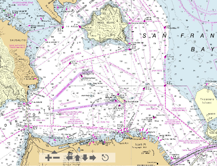
Even if “We know that changing chart formats and availability will be a difficult change for some mariners who love their traditional paper charts, but we’re still going to offer other forms of our official charts,” Capt. Shep Smith, responsible for the US Coastal Survey’s division of Marine Charts, put the best face on the circumscription of his services to the provision of PDF’s. Given that “advancements in computing and mobile technologies give us many more options than was possible years ago,” the ability to make maps available for anyone to download created a sense of accessibility and widespread distribution of charts always able to be updated–what is more dangerous on a boat than an out of date chart?–and allowed the world of nautical charting to migrate into the most popular interface of our age. It’s great to download an accurate PDF of the entrance to San Francisco Bay, NOAA Chart 18649–“Entrance to San Francisco Bay.” On it, one can find the content of earlier charts, or zoom into details at different scales, as much as its relative pixellation will allow, maneuvering in virtual form across the multicolored screen as a surrogate for moving through space. What is lost by a lack of the broader context of the chart or its interface with compass seems as odd as the sextant–or the cavalry and bayonets which Barack Obama cleverly invoked in response to Mitt Romney’s unwarranted concerns for our navy’s size.
The use of tablet computers and GPS chartplotters on both larger, commercial vessels and pleasure boats suggests a different approach to the encoding of information in nautical charts, and indeed in using the map as a basis to plot routes of travel, which are frequently confined to repeated pathways. But the frequent compression of the huge amount of graphic detail on one’s bearings to the form of a small screen–and the need to invest in a large enough screen to view the PDF in a visible form, or to find outlets where downloads can be printed on durable paper.
To be sure, the general differentials of depth are easily observed, lying as they do around Treasure Island, the pivot point of the Bay Bridge, but lines are less easily traced, measurements be noted for future sailors, or just for oneself, to be stored in a drawer, cabin shelf, or brought ashore for future examination. As we store fewer hard copies of maps, how does this change our relation to the map as an object, or change the storage and circulation of cartographical records that one can consult? Does the rise of digital mapping, as feared, decrease the sort of exchange, augmentation, and criticism of the cartographical sources or to the base-map?
The age of celestial navigation that first encouraged the rise of paper charts might be traced to the rise of a mathematics of charting nautical position whose need no longer exists with GPS services and the availability of electronic maps. If the eulogy of the Salem Marine Society for Nathaniel Bowditch, author of the American Practical Navigator (1802) that featured expanded tables for navigation proclaimed that “the name of Dr. Bowditch shall be revered as one who has helped his fellowmen in time of need, who was and is a guide to them over the pathless oceans” and needed “no monument” to be kept alive “as long as ships shall sail, the needle point to the north, the stars go through their wonted courses in the heavens,” the expansive coastline that Bowditch traced from the Caribbean islands in his “Epitome of Navigation,” the pathless oceans now seem to have paths and positions without bearings.

The broader canvas of Bowditch’s actual chart covered the entire Atlantic, over which he sought to provide tables of reckoning to tabulate navigational position within a frame of longitude and latitude that could be readily consulted, charting an oceanic expanse from coast to coast, linking the ports on its facing shorelines, framing a totality not easily processed or comprehended on even a wide screen:

What are we saying farewell to, if not an idea of reading an expansive map in paper form that can be readily preserved in the observatory of a boat, and displayed to its passengers, and to a shift in how one stores one’s own nautical maps of a course one often knows relatively well, and navigates over time? The new basis for map-use (and map legibility) suggests both a far more limited field and a less personalized basis for translating personal tacit familiarity in plotting course to the map’s format, and a far diminished intersection of map with travel lines, once limited to parameters of backlit screens that offer limited opportunities for convenient collective consultation, or for unfolding to gain a broader sense of nautical course or compass lines. Even if we are easily able to plan courses and trace routes on electronic screens by grease pencils directly on the surface of a screen in ways that can be easily erased, and download new updates of paper charts onto a handheld, and measure distances with nautical tools atop screens, if not rely on apps, does zooming in and out on screens of electronic form offer the broader contextual that a paper chart provided? While I doubt that as a landlubber, I can truly say,one worries that the end of the translation of nautical measurements to the sort of graphic syntax that lithographic maps long offered are truly as easily preserved in pixellated form.

While the interface of an electronic map with GPS may be a read herring to the downloading of charts as PDF’s , the display of data in electronic maps that is centered around the position of a ship or vessel on ocean waters seems to abstract the vessel from its surroundings: the display of data in electronic maps is constructed about geospatial position in ways that antiquates the role of reading a chart in order to determine nautical trajectory or course, by centering the screen around ship’s location rather than immersing the reader in a system or abilities of measurement. The victory of the medium of display seems a victory of the ready-made–if not a lazy model of map making. Like the self-driving Google Car, indeed, the courses of travel on coastal waters are not only almost mechanized on most ferries, or among commercial pilots, whose routes of travel are increasingly computerized, or driven in ways plotted and tracked on digitized maps.
The trimming down of NOAA would no doubt shock its founder, Thomas Jefferson, or William Maury, whose intensive coastal surveys synthesized new nautical knowledge in important ways. Moreover, in an age of global warming–when we need clear precedents of water-levels and coast detail as something like a benchmark for future decades, the production of paper maps hardly seems an appropriate bureaucratic penny-pinching. The decreased production of paper maps suggests not only a new use of the map as a basis for record keeping, but a decline in the literacy of reading the detail of our formerly exacting coastal surveys from the days of 1862.
But the very shifting of our coast-lines also suggest the need to provide readily available updates of the configuration of coastlines (who would have thought it?) in the wake of meteorological events like Hurricane Sandy or super-typhoon Haiyan, which call for the immediate remapping of a coastal bearings. And the digitized versions of these maps would offer a clearer interface with newly emerging weather patterns, not to mention the scattering on coastlines of debris from nuclear reactors. At stake is, essentially, whether electronic charts or downloadable PDF’s offer a format removed from the tactile knowledge that is considered the basis of nautical navigation. If the basis, it is not the sine qua non, but it does provide an eery bit of evidence of the colonization of GSI of the world of the ocean seas, as the ocean approaches a form of ready scanning and tiling that stands at a far remove from the tactile sense of unknown otherness once associated with them.
With the dominance of the practice of mapping actual position, we may sacrifice the notion of the structuring of voyages exploration along routes of known islands plotted on a global, rather than a local, surface, one senses, together with specific ways of mapping travel in oceanic space or the ocean as a distinctly different medium of travel.
But the question of how we will continue to navigate our coasts with safety of necessity depends more on understandings of precision and efficiency than it is to the range of options of nautical travel.

