
19. Concrete markers were also memory traces on the US-Mexico Border, long before Donald Trump started talking about the need for a steel-core concrete walls exposed to weather were the haunting basis of the border wall. The grids of rebar that are the basis for much of the concrete places in the open were never constructed along most of the expansive border President Trump was famously loath to compromise, and the dream of building a concrete wall that led him to tour the Rio Grande There was a sense that the fault-lines and divides we have made through maps peeled apart from the global sense that the marker gave to geospatial position, by asking the viewer to embrace that random point on the globe with two pieces of bread. Perhaps the jokiness of the inscription pried apart the coexistence of different eras of marking space primed me to consider how our forms of marking as ways of making public information legible in our landscape, haunted by the spatial addresses of geospatial location. For the mundane bench mark before me played with the notion of hexadecimal spatial addresses in ways that seemed to look up to the grids that were increasingly wrapped around and superimposed upon the earth with surreal absurdity.

Bench marks on the southwestern border had long created legibility in the landscape, rendering geospatial coordinates legible on the international divide. One senses the excitement of these claims to legibility in the effort to meld maps and life in the markers that the United States Geographic Survey sets into the ground that mark a datum of elevation or azimuthal mark, for coastal surveys or early networks of surveying: nowhere more than in the set of markers set up on our southern border to mark the border after the 1848 Treaty of Guadalupe Hidalgo, discussed in my last post, to inscribe in the sand an affirmation Mexico transferred sovereign claims to California Alta, Colorado, New Mexico, Nevada and much of Arizona; surveyors set cairns in the uninhabited regions for no observer in particular, “in consideration of the extension acquired by the boundaries of the United States” that had been recently expanded as the federal government bought new land from where El Paso meets the Rio Grande river due west, for the bargain basement price of $15 million that was basically dictated to the Mexican government at the conclusion to the war.
They left as markers stone undressed mounds, without mortar, to “perpetuate the evidence of the boundary” on the 31°20′ parallel and the 31°47′ parallel, to persuade viewers of the authority of the new national map: this was a collective attempt at boundary-drawing that led stones to be amassed at regular reminders, attempting to immerse anyone on the ground with the authority of the map beyond the triumphalism of the fourteen foot high Border Monument #1 seemed set on unclaimed paradisal lands, as if determined by a process of divine reason–markers that were increasingly, however, cast in concrete in far less glorious terms as a reflection of divine reason.
The point bore the clear message, made more legible to visitors by the painting in of its legend, making its cartographic function legible by proclaiming the “staring point” of a border scarcely apparent in the terrain.

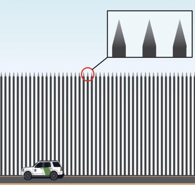
The astronomers located the exact coordinates the Guadalupe Hidalgo treaty had agreed upon, because not only was the 2,000+ miles of the border agreed to be impossible to manage by human observers, but such sentinels of stone provided the only sensible way to let the people who crossed it–without GPS or maps–to know where they were as they moved across what were almost entirely uninhabited mountain ranges. Although these early markers were replaced by obelisks by the 1890s, the current attempts to replace these markers that left the boundary present in the landscape, but left borders “open,” had been treated as a way to bait racist groups of border guards and vigilantes, by being sacralized as a bulwark of alleged invulnerability, as if the “open” borders failed to offer a reassurance of America’s geopolitical sovereign identity in ways obelisks stationed at regularly spaced intervals–as points of orientation or topographs more intentionally visible earlier border markers–had failed to provide.
The piles of undressed rocks were forms of governance, and an improvised antecedent of the boundary wall. Their pastoral presence was evidence in the landscape that a “true line shall be the record to which all disputes . . . shall be referred,” established to link the land to the map. In 1851, teams of astronomers, cartographers, mountaineers, and artists, often veterans of the US-Mexico War assembled undressed cairns, only later replaced by permanent obelisks standing every four miles in a single line of sight, inscribed in the landscape to render the boundary’s arbitrary line visible if not naturalized, by “tracing upon the ground” in. the landscape. The situation of such topographs sought to “perpetuate the evidences of the location of the boundary” on six hundred and fifty eight miles along the 31°20′ parallel and the meridian connecting it to the 31°47′ from El Paso to San Diego. The Chief of the American Boundary Commission, Col. J. W. Barlow, remembered moving with his men “steadily . . . over much desert and some valleys that would be fertile if there was any way of storing water . . . over many mountain ranges,” to stabilize the boundary between both nations, as if to domesticate and maintain vigilance over an open space of which “a great deal of the country was rough and wild.”
Barlow led a federal project of rendering the border legible became a mission of reopening of the west, but also of rendering the line legible, independent of topography, bioregions, or existing land claims. The resurveying teams of 1891-94 sought to demarcate a spatial difference in more monumental terms, to correct past mistakes and ensure none were swept under sands or obliterated to view, placing sequentially numbered neoclassical obelisks that must have been ordered from quarries where the determined boundary lay. The obelisks that invested the border with legality seemed almost cenotaphs of the burial of the cross-border migrations over space.

–or hiring laborers to erect new monuments from masonry, all photographed for posterity.
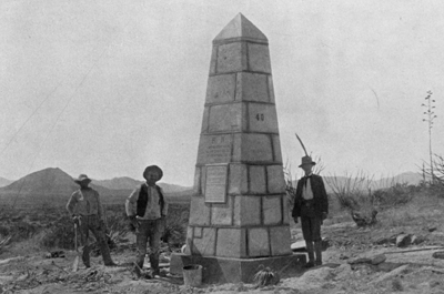
After an initial use of marble to create neoclassical monumental markers, the poured concrete obelisks provide a reminder of the past efforts to lend stability to the border that the walker of the border, David Taylor, encountered and documented in an extended photographic essay. The monumental boundary markers of the 1890s stand today stoically beside far more brutalist border wall that transform the dots of a map earlier markers to a continuous line: La Mojonera, the first obelisk of Italian marble was set with fanfare above the Pacific, the first of what were only fifty-two border monuments, arrived by ship from New York. The laborious expansion to two hundred and fifty-eight monuments that lay in a single line of sight extend from the west bank of the Rio Grande near El Paso at exact coordinates, as two surveyors and a team of astronomers and artists covered almost 690 miles in two years, making sure that the obelisks lay in clar visibility of one another as if to render the land as visible as a map: Border Monument #1, overlooking the Pacific, now became Border Monument #258, overlooking the Pacific, but most of the two hundred and seventy-five were lugged with effort and expense as legible evidence as if dots on a border line. These markers serving to map space parallel the concrete markers of pavers I see in Berkeley, as a poignant echo of past efforts to define a fixed relation to space.
The aesthetics of permanence that developed in Berkeley as a form of fireproofing by Bernard Maybeck was a new architecture of the border and a monumental architecture of border commemoration. While Maybeck was meeting with contractors to familiarize himself with the medium, some seven thousand pounds of concrete were poured over a million pounds of rebar in San Francisco, to create a new arts museum on Lands End in San Francisco, the Legion of Honor, after the French Pavilion at the Panama Pacific International Exhibition, but Maybeck expanded his own architectural tools to a medium championed by modernists, but before the brutalist concrete bollards, obelisks marked the US-Mexico international border line.


Photographer David Taylor grew increasingly entranced by the sequence of monuments, now set against bollard fencing and as a vain attempt to make the boundary line impermeable as it might be imagined on a map, “captivated by them,” as a network of inanimate informants about “our changing national identity.” They offer a poetic testimony to the long open nature of the border, and a contrast to the image of security in the fantasy of restoring complete border security. Taylor’s eloquent photographs capture the overlapping spatialities of the border at the moments where they intersect, revealing an archeology of the border space in quite poetic terms as an observer who observes the archeological layering that still exists along the border, at sites where the border fence that asserts a clear divide of nations seems more of a palimpsest of the border spaces that have existed over the same terrain.
The overlap of these senses of the border markers, as they were poised to be erased by the continuity of a border wall, were photographically captured by David Taylor during the doubling of border wall built on the southwestern border, and on the eve of the expansion of the border in national debate, and the United States government built over 600 miles of new pedestrian fencing and border barriers: as the border was increasingly structurally reinforced and the size of United Stated Border Patrol doubled, Taylor’s series of photographs remapped border from the position of the border walker, as the border was redefined by seismic sensors to track pedestrian cross-border passage. Taylor walked in the project Working the Line moves from El Paso/Juarez to San Diego/Tijuana, provided not only an artistic account of border monuments in their locations, but lift the finality of the present by showing intersecting spatialities, one peeking through the other, of the 276 geodetically fixed obelisks, set from 1891-95 to mark the international boundary as if to make locally legible a globally recognized line; setting these obelisks, often along desert terrain or on mountain ranges, secured a sense of the border that could not move or be moved, more permanently legible than the cairns that might erode with time or be destroyed; at the same time as Albrecht Penck was proposing an International Map of the World as a model of global concord and shared mapping standards, and as Frederick Jackson Turner bemoaned the closing of the frontier, the obelisks marked national space on the ground set definite bearings. Turner interpreted the finding in the 1890 US Census that the “unsettled area has been so broken into isolated bodies of settlement [in the nation] that there can hardly be said to be a frontier,” lamenting the closing of the frontier as a site and resource of national renewal; the marble obelisks that punctuated the international boundary treat the border as settled and fixed in global space on a legible map.
Taylor’s walks cast these obelisks in an almost almost pastoral landscape, against the spatiality that map an enforced border fence as a a tactical line of military defense. There is an undeniable sense of tragedy in the border obelisks Taylor encounters: while Turner felt the frontier a crucial liminal space for democracy and a “gate of escape from the bondage of the past” and the dangers of social hierarchy and cultural decadence on the European continent during the 1890s, the stability of a border no longer open to pedestrian passage convey a sense of deep tragedy and loss. But those old obelisks first attempted to trace a legible line in the landscape of international boundary for all passersby who came across them, the rigidity of the installation of “barrier fence”–the immediate antecedent of calls for a Border Wall–suggest the explicitly militarized borders that had already begun to replace them, imagined as a tactical barrier to the “potential illegal alien” (PIA) who might be apprehended by the border patrol agent (BPA) in adequate time to make the request, given the needed detection and tracking coverage by which the “alien” might be tracked and apprehended by agents before s/he reaches the “vanishing point” of no return. The ability of geotrack locations of a “IA” or “PIA” coming from the south of the border became a calculus for border agents to prevent migrants from moving through open gaps, the “illegality” of whose crossing the border was presumed by the Department of Homeland Security.


Thanks for this wide-ranging meditation on our sidewalks. They’re a palimpsest of East Bay history, a diachronous record in constant turnover, that anyone can start to read once they turn their eyes to their feet.
https://oaklandunderfoot.com/
Indeed, it’s hard not to read a story of urban expansion and landcover change. The palimpsest of temporalities is cool to discover. I was amazed to find a Blake and Bilger stamp, as best as I can read of 1909, on my own block. The range of WPA strikes in many neighborhoods from Temescal to Sausal Creek evokes a large effort of local improvement, as well.
Thanks for this wide-ranging meditation on our sidewalks. They’re a palimpsest of East Bay history, a diachronous record in constant turnover, that anyone can start to read once they turn their eyes to their feet.
https://oaklandunderfoot.com/
Thank you! Indeed they are; while inspired by the very local pedestrian walks made mostly in the Lorin and Elmwood, I benefitted a lot from the great online commentary they’ve received.