
Who is to say that this isn’t a better use of mapping tools, after all? In the several square blocks of south Berkeley CA I found myself over the first year that COVID-19 spread globally, where I’ve lived on and off for almost thirty years, those stretches of sidewalk that had not in need of replacement from cracking or house construction offered a memory theater of some sort of, imprints of pavers a register of signatures of contractors whose marks, at a moment of heightened mortality, gained greater commemorative functions as a sort of public memory in public space, calling attention to themselves to punctuate walks in a pleasant material interruption of the past that I had long overlooked. And as ways of commemorating and accounting for escalating fatalities seemed somehow stuck in the craw of the nation, blanketed by the denial of a state of emergency or even viral communicability, the names pavers stenciled in the sidewalk underfoot gained a poignancy as commemorations–sites registering the temporal flow that seemed to be pouring across the world now like a crimson tide.
Reading the century old concrete strikes on the public property of the streets seemed a sense of marking territory or taking back public space, in a very local way, as our sense of the public spaces open to us had corroded and grown frayed. Across the street from that benchmark noting antipodal relation to the Indian Ocean, the strike of a paver jumped out at me to register a deep temporal flow from over a century earlier, and the first era of the paving of sidewalks in the Bay Area, not long after Nat Lena began his craft, and early twentieth century pavers like J.A. Marshall–who set among the earliest surviving strike on a sidewalk in Berkeley, CA–began what must have been a booming trade to pave public sidewalks, adding concrete outside the gated 1889 Victorian at Fulton and Blake.
Strikes on the sidewalks increasingly offered fresh ways to look at neighborhood whose streets where I spent more time, and a way of getting bearings on its built space: even this marker stared back at me, with a sense not of nostalgia, but of presence, of a past inhabiting the present’s own augmented sense of mortality, measuring these strikes as if they contained a mystical properties in a truly early modern sense as touchstones for exploring the city in my early morning walks in a newly empty city-space. Was the upright elegance of the font of thin capitals a distinguished font designed to define the exclusivity of single family residences on Prince Street?
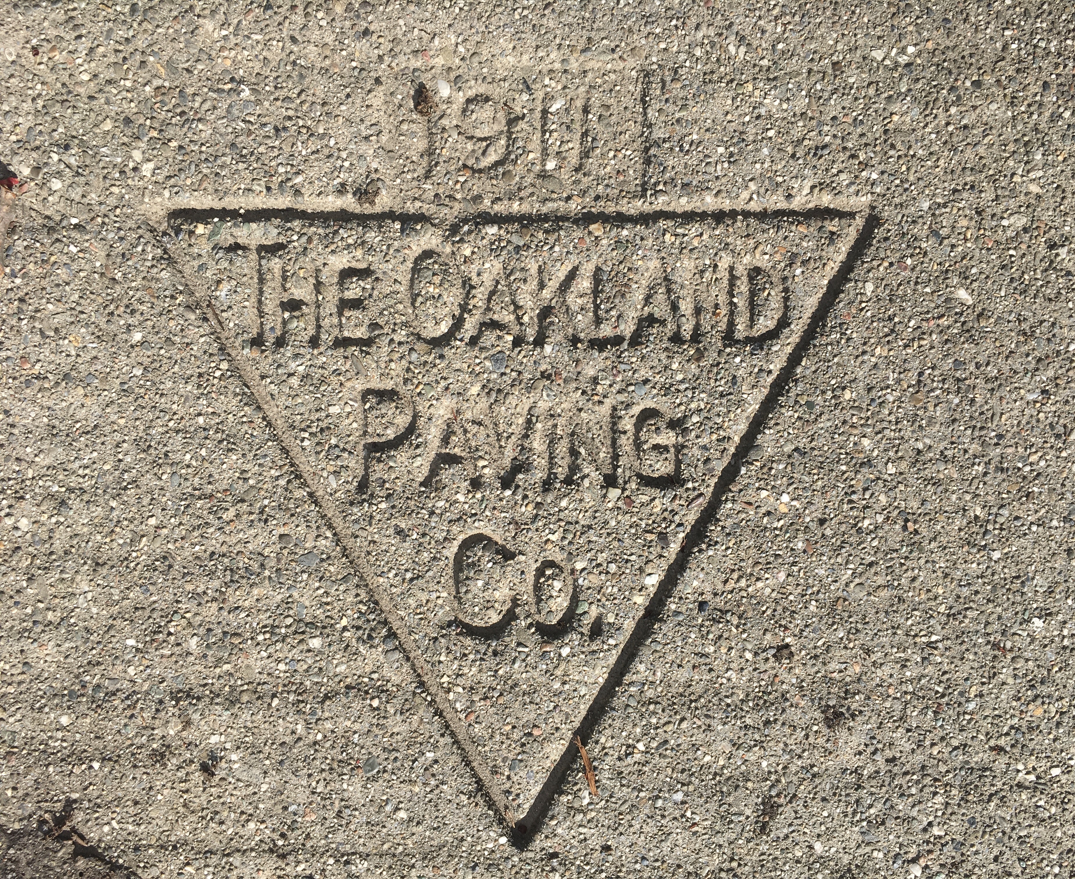
The “Oakland Paving Co.” was founded in 1902, exploiting the availability of local quarries to provide pavement for Berkeley and Oakland when concrete had become a boom industry, profiting from a local Rockridge Quarry that lay off Broadway and 51st St. to provide paved sidewalks in Berkeley that only grew after the devastation of the 1906 San Francisco earthquake, pancaking many residences and prompting fearful migration East Bay.
Perhaps an echo of that catastrophe was in a sense legible in the imprints of pavers who had laid “art stone” on the ground or plank roads on Prince Street a century ago, as the survival of these strikes on what might be some of the less traveled streets still crisply stood out on the ground, that paralleled the pavement of once open space–and providing what indeed seemed to fit the demand for “art[ificial] stone” to dignify its pedestrian space.
The classification of concrete marks and strikes made such botanizing of the asphalt apt for capturing pandemic melancholy that was concretized in concrete of these older artifacts of the urban environment. There was something akin to a botanizing of the pavement in the search for signatures of the local past, personifying the ability of “botanizing on the asphalt,” not to get lost in the city, but orienting oneself by its signs: the first introduction of pavers’ marks was “art[ificial] stone” and a form of urban artifice, framed by grasses, but where walking suggested new forms of attention that transcended the natural. Benjamin’s “botanizing on the asphalt,” a turn of phrase both suggesting the new habitat of the late nineteenth century, as an ethnographer of urban space that linked nature and manmade concrete creation.
From 1906, newly laid grid of the city of Berkeley had beckoned settlement in its multiple tracts from local realtors, to meet demand for resettlement that expanded after the 1906 San Francisco Earthquake shocked the Bay Area, at a time when the East Bay was more distinguished by unpaved open space, and far, far less sprawl to wander.
12. I did a deep dive into pavement studies as a way to track buried divides. Looking with attention at the ground, finding myself a flâneur in an area I knew well, the streets started to speak back, as if with voices of the past gained a surprising testimonial vitality about which I almost grew passionate. The stamps offered a sense of transport at a time when we could no longer travel far, and lived with preoccupation. There was something comforting in re-reading the neighborhood, its sense of place and relation to space, that I could internalize in the somewhat tentative walks that led me to look for new bearings, and saw much more of and with different eyes than I had in the past, as if looking for new bearings to orient myself to the lay of the land, and to look back at its inhabitants about a century earlier in time. If New Yorkers feel like those acknowledged to be true New Yorkers not only knew the buildings or coffee shops of the neighborhood but what stores they had replaced, and what stores were replaced by them, stretching ten or twenty years past, to describe and rank their levels of familiarity with a built space, knowing who paved the streets’ sidewalks n the younger city of Berkeley seemed to offer an index of the intensity of familiarity with place at which I aimed: these men, if many dropped the helpful habit of naming the date of laying concrete over what I imagined a bit romantically was a dirt road until then, provided guideposts to the region which had mostly all fell below the radar in previous years.
Or perhaps there was something elemental as a system of orientation to these names, that made up for the absent crowd of passersby on the streets. More than the shifting names of university buildings, public schools, and even cities, recently enacted based on a hopeful if misguided decision to cut ties to the past, the names embedded in the pavement seemed signatures of oddly fragile testimony about the past.
Hand-pressed mementos of past pavers and contractors were less confrères, than memento mori in days of social isolation as the progress of the pandemic grew for almost a year, and we awaited for better signs of global orientation before uncertain tallies of infection all summer long, despairing of purchase on the pandemic, often by taking stock of how little we knew, the return to local signs for bearing were not only the result of downcast eyes. As much as an obsessive antiquarianisms, the strikes promised an alternative orientation to the meaning of place from the men who laid the street underfoot. The rise of the horse-shoe print of W. Ensor from the 1920s suggest a strike that evoked the horses of an era of traffic before the introduction of “art[ificial] stone” replaced the wooden planks of the 1880s. the It is hard not to be struck by distinctive horse-shoe imprint of local paver Ensor H. Buel, master contractor and builder, whose trademark strike, appearing soon after the introduction of trademarks, the distinctive signature of the contractor who built it and it remains a surviving mark of their craft–
Etched in what had been the once modernist medium of concrete, the often worn stamps of J.A. Marshall, perhaps the John Marshall who in 1905 was a “cementwkr” Berkeley’s directory, left his escutcheon as a calling card that gained epitaphic quality, as a trace of the everyday as I fled the outside noise and pandemic fears: what some describe as “fossils in concrete” triggered a sense of musing on the everyday and marking of place rooted as much as anything else in a search for historical redemption beneath my feet, including an imagined network of modest community Italian-American immigrant pavers whose concrete sections have survived a century.
If strikes were potential warrantees in case of liability, the promotion of the craft reflected a pride in craft that made them appear testimonies to their contribution to the spaces in which I moved with less surety. It must have been a sort of validation of pride, as well, and a sense of locating one’s signature in a place, of personal importance: the marks of past occupants seemed like fragile memories of a past. The pandemic increasingly brought a sense of reckoning not only with mismanagement, but a tragic loss of public memory, exceeding the loss of individual souls. I read at a removed obituaries in lists of the dead that were printed in the early days of the pandemic in northern Italy, in what seemed expanded section-sized obituaries obligatory and entrancing to read to affirm a common humanity, as if to try to process the scale of persona devastation, as an expanded version of the “Those We Lost” section that the Times had, as I remember it, pioneered in the days of 9/11, and that I remember reading on busses as I moved around Manhattan, months after the three terrorist attacks by exploding airplanes into sites including the Twin Towers. The scale was far larger, and global, and even harder to comprehend and mark, as the scope of the levels of infection, hospitalization and mortality that all seemed alternate proxies for intense loss.
Amidst a heightened sense of contingency grew over a long winter, I read dead pavers’ concretized calling cards in new ways as a telling archeology of a past lying underfoot seemed to rise to the surface in curiously passionate ways. The paving of Berkeley streets might be bracketed by dual catastrophes of another era-the 1906 San Francisco earthquake having prompted to increased settling of the city of the city across the bay, bringing a boom in paving, already facilitated by cheap cement to make concrete; concrete industries and cement work expanded as a craft allied with architecture, after the 1923 Berkeley fire, not only for reasons of identifying builders in case of liabilities, but driven by a search for building materials impervious to fiery holocausts that expanded the profile of concrete contractors among the architects with whom they were already allied, if more as laborers than artisans. Twin changes that shaped the modern life of concrete streets and the paving industry–attracting workers–provided a basis to frame the genealogies of these pavers–and the ornate signs contractors left on the ground, not only to guarantee the security of pavement in case of accident but perhaps to align their craft with builders and architects.
The medium of “artificial stone” gained popularity from the 1890s in alternative to the granite slab sidewalks of major east coast cities, as the cost of cement from 1900 to 1905 dramatically decreased, was marketed as “art[ificial] stone” in more ways than one, it seemed, as storied architects like Bernard Maybeck and later Julia Morgan and John Galen Howard adopted concrete as their craft, as earlier architects had used limestone for its facility, elevating the concrete arts to a building craft one might sign. The popularity among pavers’ strikes of a device like the escutcheon suggested a sense of pride in shielding the ground by laying wet pavement, as the family of contractors who had become the Schnoor Bros. one reverie went–Paul Schnoor had laid pavement from 1908, in Berkeley, and was an old hand whose family business expanded as Bay Area pedestrians grew in number, and their prints are evident along Claremont Avenue and College Avenue as well as many other early residential streets.
There seemed some redemption in these signs. I suppose I turned to the paving signs with a new sense of time’s passage. As birdsong of chickadee and warbler had warbler increased their range and pitch, filling up the absence of traffic and the background static of traffic sounds ornithologists identify with a distinct broadening of birdsong range from the first months of the pandemic, white crowned and yellow crowned sparrows roosting in the nearby bushes sign with fewer distractions from ambient noises, making it seem that I livd in a bird store as they bravely doubled their range and lowered pitch. As if analogously to how the birds re-explored and settled semi-urban and urban space with surprising rapidity, drawn by the drop in industrial noise and car sounds, the still of the pandemic provided an opportune occasion, I suppose, to focus a bit obsessively on pavers’ imprints gave me a new sense of navigating built space with far fewer actual pedestrians about.
13. The change in the ambient sounds of neighborhoods across the Bay Area, noted for its extended commutes and building expansion, has made it a sort of paradise for birds and for birdsong, encouraging amateur ornithologists to look at their back yards to practice citizen science with renewed vigor: road runners have popped up on Facebook as well as many requests for identifying birds seen outside one’s house. Ornithologists have confirm the arrival of birdsong in urbanized areas in the pandemic in ways that have a counterpart in much musing of how we will inhabit and work in space and place in a far-off future.
And as birdsong seemed to restart of dropped discussions about place and space, benchmarks seemed to offer to take up a discussion we had lost. This was a collective experience of the pandemic, which in 2020 had staged a collective experiment of sorts in active listening and recognition of a shifting frequency and range of birdsong, as Steven Lovatt noted, as the pleasurable byproduct of lockdown, able to “short-circuit time” as one recognized the sound in life-affirming ways. I reading paving stones as a text underfoot, in those areas where strikes weren’t entirely effaced by a century of pedestrian traffic, rain, or repaving, and lost, as if they offered evidence or testimonies of forgotten building trades rose to the surface of public memory.
The enhanced attention to the solitude of song seemed a rejiggering of relation to place, as if the presence of birdsong offered an unearthed language that made Charles Darwin’s theory that the melodic structure of birdsong, perhaps attributable to “mere happiness,” was nothing less than the most evident analogy for the expressive structures that gained lexical qualities of indication, description, and volition in language, I became more attentive to a “forgotten aspect of the grammar of reality” other languages of place, even drawn to identify the sounds of birds perched in the branches of the two sweet gums outside my front stoop, not only as sparrows, by by their trills, calls, and plumage. Darwin’s sense of the communicative nature of birdsong seemed alive in the apparent expanded range encouraged by a drive to vocal learning in the trees, the renewal of this phonological syntax expanded one’s sense of place, as if bearing new information about the opportunities that a partial lockdown opened up.
There was a sense of the observation of the workings of the mind, and the markings of space, or of watching oneself with alertness as a reader of reality. And the marker that is in the header to this post, when I seemed to discover it, provided the impetus for reflecting on the changed spatiality of the pandemic; I stumble across them, pause, and see them as evidence of an earlier spatiality, as if buried in time, but traced on the pavement as a form of mapping geographic information of an earlier time. Over a year, it came to be imagined as the center of the new neighborhood I was in, or at least a new place to gain bearings, a sign of the affirmation of a part of the neighborhood I never saw and that captured a sense of a community even with far fewer folks on the streets, or chance conversations. The rich archeology of spatial knowledge appeared written on the pavement, as if social distancing left me open to seeing voices on the ground, as much as pounding the pavement o my neighborhood. Perhaps this is somehow a search for escape, or momentary transcendence of the existential condition of sheltering in place, or more likely the guiding trope is the reveries of the solitary walker, finding transcendence not only in the natural world, but in apprehension of traces of older cartographic regimes and markers, as something like a puncturing the regime of social distancing.
But the sign of what seemed a forgotten group of bench marks on the pavement of the street near by house seemed similar to ghosts in the neighborhood that popped out with newfound and unexpected clarity as lost but legible registers of the past. For a map-reader who has excavated traces of the past preserved in maps, it was striking to find them in the ground beneath my feet, as if the names and lives of the men who had set their names into the pavement with strikes scattered across the city might be a map of traces of lived space. This is not only the evocation of a community with comfort. Roman Mars described how the mundane imprints of sidewalk stamps as “a fun kind of x-ray vision” into the community, from the markers of the acknowledgement of disabilities rights activists in Berkeley, or, perhaps, the immigrant communities of pavers whose firms set concrete sidewalks across Berkeley and Oakland, many of whom were indeed trained by contractors who had arrived in the Bay Area or San Francisco with nothing–men like the Italian immigrant, Nat Lena, the contractor who came to the United States in the early 1900s, arriving in San Francisco with a few dollars in his pocket, at whose concrete business many future pavers honed their craft, from Lino J. Lorenzetti of Puglia, who set up shop in Alameda in the 1950s, after learning with Nat, as did Angelo Sposetto, George Jardine, and Aldo (A.J.) Ferraro, who set up their shingles in Alameda in the 1950s, as the island was being repaved, all of whom set their names on the public property of the sidewalks as the final touch as they left the pavement to set. from the austere diamond drawn around the stamp “A. Salamid” to the blocky punches that served as a logo for “J. Mottino” at a later unknown date–
–to Oakland’s “Rosas Bros” in recent years,–
–but I treasured the precise dating of strikes of older pavers, often set in a more rocky concrete of a removed past.
There was a sense voices rose from the pavement in the streets that were rarely traveled, where the names not yet worn away by pedestrian traffic in the older neighborhood I had recently moved still lay traced on the ground. I encountered older elegant imprints left by “H.C. Orth” of the Cement Contractors Ass’n from the 1920s–later “Orth & Braun, Berkeley,” and the early strikes of Schnoor, before he was joined by his sons. Did there seem the possibility of redemption in reading these names, as if respectfully scanning so many epitaphs?
Pavement strikes placed the work of the individual in the world, and allows one to trace a palimpsest of sorts, archeological evidence present but overlooked of generations of builders, often set off in rectangles, half-circles, circles, lines or elegantly arched text, if not the preferred devices of an escutcheon or oval, reveals an illuminating online key of the stamps contractors placed on local sidewalks–at least in Oakland. Is the device of an escutcheon emulating a coat of arms a worthy sign of investing meaning in the apparently routine thankless paver. The precious surviving strikes we have to be grateful to survive and not to have been repaved over time, even as they were worn down by pedestrians’ feet? Escutcheons seem to have been preferred by old pavers, whose work shielded the ground, if the emblem of V. DiZillo seems a stop sign of sorts as it catches my eye on Dana Street.
The same paver had left a considerably crisper mark, some five years earlier, perhaps, in paved sidewalk in Oakland off the Sausal Creek by Grand Avenue–
The stamped names oriented me to the neighborhood, as I watched birds re-familiarize themselves with hedges and overhead routes, and lower ambient noise. Many were the Old Italians of whom sung Lawrence Ferlinghetti, in a poem I read during the pandemic, dryly narrating a chronicle in which “For years the old Italians have been dying all over America:/ . . . the ones with old pocket watches,/ the ones with gnarled hands and wild eyebrows/the ones with the baggy pants, both belts & suspenders/the grappa drinkers with teeth like corn/the Piemontesi the Genovesi the Siciliani smelling of garlic and pepperoni,” those “who loved Mussolini/ the old fascists/the ones who loved Garibaldi/the old anarchists reading L’umanità Nova,/ the ones who loved Sacco and Vanzetti.”
–among other trace of what librarian Lincoln Cushing argued superimpose on the physical plant a sea of “ethnic surnames echo the immigrant waves of the past.” There was a weird dissonance, I suppose, between the past of their construction and the present, as if the motley crew of Californians constituted the quarantine bubble in which I was isolating outdoors, consulting them for a needed perspective on the current crisis of public health, as well as a sense of tracking the former inhabitants of the region, locals who had laid pavement before I was born, less as guides but bearings, and perhaps men whose works and lives were worth remembering.
14. Stamps traced careers over time, like the contractor Ensor H. Buell, who partnered with architect Bernard Maybeck, who, in after 1923, relied on local contractors to expand the architectural uses of concrete as a medium in from the turn of the century, from buildings like the pillars of the First Universalist Church (1910) to the concrete fireplaces after the massive fires destroyed much of Berkeley’s elegant residential neighborhood in 1923 from chaparral and grasslands to destroy 600 homes across fifty blocks that led to a new market for concrete.
The fire sounded a death toll for the mania for residences from cedar in the “Arts and Crafts” movement: the forest of chimneys left in its wake perhaps prompted re-evaluation of concrete, already a modernist building form, as a worthy medium for roof trusses, after loss of homes by Maybeck’s many clients as well as himself: Buell and Maybeck pioneered “concrete houses” in what he called “bubblestone,” working with contractors to adapt concrete as a medium able to withstand conflagrations in response to demands for fireproof construction.

The permanence that concrete promised seemed a fit to contemplate in a time raising questions about what would endure. Did the local rise of concrete artisans create a new surety of staking out independent contractors’ crafts, using translucent glass blocks, and several buildings which Buell himself built in West Berkeley?
The current spread of the pandemic marked time in a similar caesura, but looking at the ground more than stamping the pavement provided a suitable way to The stamps offered snapshots of the urban planning as an organism. I’d long treasured the stenciled names as a form of graffito bearing hidden messages of past generations and a sort of open source memory, as if the surnames belonged to forgotten pavers, a durable if neglected repository sitting before our eyes on the pavement, offer mark a form of public memory long-neglected. An informal survey based on city walking during the pandemic suggests an expansion of the stamped signatures of contractor-craftsmen led me to posit a First Era of Sidewalk Paving from the turn of the century, after which stamps stylistically expanded in the 1920s to the Elmwood and West Berkeley, as well as downtown.
The less legible nature of many worn marks over time seemed to suggest a sense of the passage of time.
Such early morning reveries on the way to the coffee shop interrupted my walk as I returned to what had been a prompt for early reading exercise for my daughter, but had gained now meaning as access to a past geography. The stenciled strikes my have been laid as a form of security against liability, that paralleled introduction of trademark law in late nineteenth-century California, the names crowd-sourced a transitory cartography as a forgotten form of registering space that was an antiquated spatial literacy, as much as mere antiquarianism. The marks that punctuate College Avenue of Schnoor Bros., A. Salamid, or are evidence of the topography of single-family residences that defined the neighborhood in the past, even if the area was recently one of in-law apartments, home expansions, and remodels.
15. If scarcely akin to buried memories of a removed past that peak from flagstone pavements in Berlin–not nearly so evocative of trauma as the far more intentionally placed stolperstein, commemorative plaques marking or interrupting the walked surfaces of Berlin’s pavements, and now of many other German cities as well. In Berlin, they were born as an artist’s project, aiming to recall the sites of residences of Jews or other deported in over three thousand “stumbling stones.” In many ways, the act was a democratization of the notion of the monument, but moreover to the residents of a city where thirty-eight synagogues once served. The monuments on the ground were minor, but intentionally placed to evoke reflections–“Stolpersteine,” stones causing pedestrians who pass through the city to reflect, and figuratively “stumble” as they complete their tasks in the city streets. While begun in Berlin, among the city streets that are now seem to be laid out like a library of the classics of a culture in which Jews had a marginal if distinct terrain of Tuetonic high culture–Kantstrasse intersecting with Leibnizstrasse, near Goethestrasse–to restore the memory of the systematically deported at the very site where they lived, now including 2,980 names of persons who are remembered in other German cities–save Munich–place ten by ten by ten cm brass markers inset smoothly into the ground, in a collective effort of remembering requiring one to research the past dates of deportation, birth, and execution of the men and women who lived at a given site, restoring their presence in some partial way to one’s own memory.
The placement of these memorials interrupted the flow of paving stones by dates of birth and date of death, but not to be reduced to them. The database in the streets of German cities is a sort of effort at repatriation of those expelled and the act of expulsion from the body politic, and a hope of coming to terms with the past death, but began not as as state-sponsored or a community-based form of commemoration, but from the mind of Cologne-based artist, Gunter Demnig, who, from 1995, placed such thirty-one such plates among the paving stones of Berlin’s streets, as an improvised memorial to past inhabitants, that have multiplied as a form of collective remembering; these memorials, or anti-memorials, assumed apparent ethical functions of coming to terms absent from German public life, as the public memory of the Holocaust grew fragile, placing over 75,000 and now almost 3,000 placed in over twenty European nations, as a material repository built-in to the paving stones or medallions of former members of the local community whose dwellings were confiscated as they were deported: the solemn stones preserve their memories, and offer prompts to recall the shadow city that exists in parallel to the current city, as if it was, in some alternate universe, both accessible and alive. Beyond Demnig’s project, they have encapsulated the drive to memory that was absent from anywhere in America–perhaps it had not mapped so clearly its historical trauma, or been able to process them–property rules trump public memory.
Although some German cities hesitate at permitting them, the project of such seamless integration into the surface of the street suggests a psychic interruption of one’s urban itinerary, forces one to be interrupted in one’s walk to process or take note of a real historical problem of remembering as an active effort of coming to terms not with the occurrence of the past but by affirming continuation of its traces in to the present, invested with human identity unlike the poles at Wittenbergplatz in Berlin that list distinct metal place-names of the site of deportation where many of these individual died, beneath the commandment-like inscription, “PLACES OF HORROR WHIHC WE NEVER DARE FORGET,” but is itself placed outside the urban context. The idea that has evolved of the ethical practice of reading and perhaps honoring the name on a brass plate, now smoothly set as integrated into the surface of the street for the life which had once been wrenched form its urban fabric, appears a hope of restoring an individual who was killed to the city’s space and collective memory in an amassing of individual testimonies of their lives, by their names and dates of death. These are less monuments removed from urban space, than “anti”-monuments, integrated in one’s daily commute or jaunt to the store, not at a site for shopping that would make them easy to be overleaked, but that seemed to be intended for the urban walkers that Benjamin described as “botanizing the asphalt” in cities, would jump out at the urban walkers and take hold of them by their dull brass sheen as parts of the landscape from which former urban residents had been wrenched. This is a work of Vergangeneheitsverarbeitung, a work or need of accepting and re-integrating past urban inhabitants in lived space.
Pavers are not victims of extermination. But point was that they, too, made me pause, as anti-monuments, that both arrested me on walks and shot me to another time, when I wanted to leave or abandon the present. Their very unseen visibility seemed the reverse, in both cases of the inevitable invisibility many prominent planned monuments that seek to monumentalize the past or commemorate a hero can acquire–the sense of being “conspicuously inconspicuous,” as Robert Musil put it, in a short piece on “Monuments” of 1927. Considering how the monuments built on battlefields or in cities after World War I threaten to disappear from public life, Musil asked his countrymen, shortly before the postwar proliferation of monuments and commemorations, how monuments often repel rather than attract attention, despite their intent, so out of place where they from the urban fabric in which they were situated and were once intended to be gazed upon. Musil argued that the monument indeed, due its lack of integration in the urban fabric, become naturalized as voids of particular interest for how they almost elude our faculties, as they place themselves out of our perceptual attention. Musil felt that there was “nothing in this world so invisible as a monument,” but the inscriptions on shiny stolpersteine push back against forgetting of an event by refusing it is removed from the immediate, less challenging to conceive in its totality, but rendered poignant and pressing in the individuality of the interrupted lives once dwelling at the place where the passerby stands today.
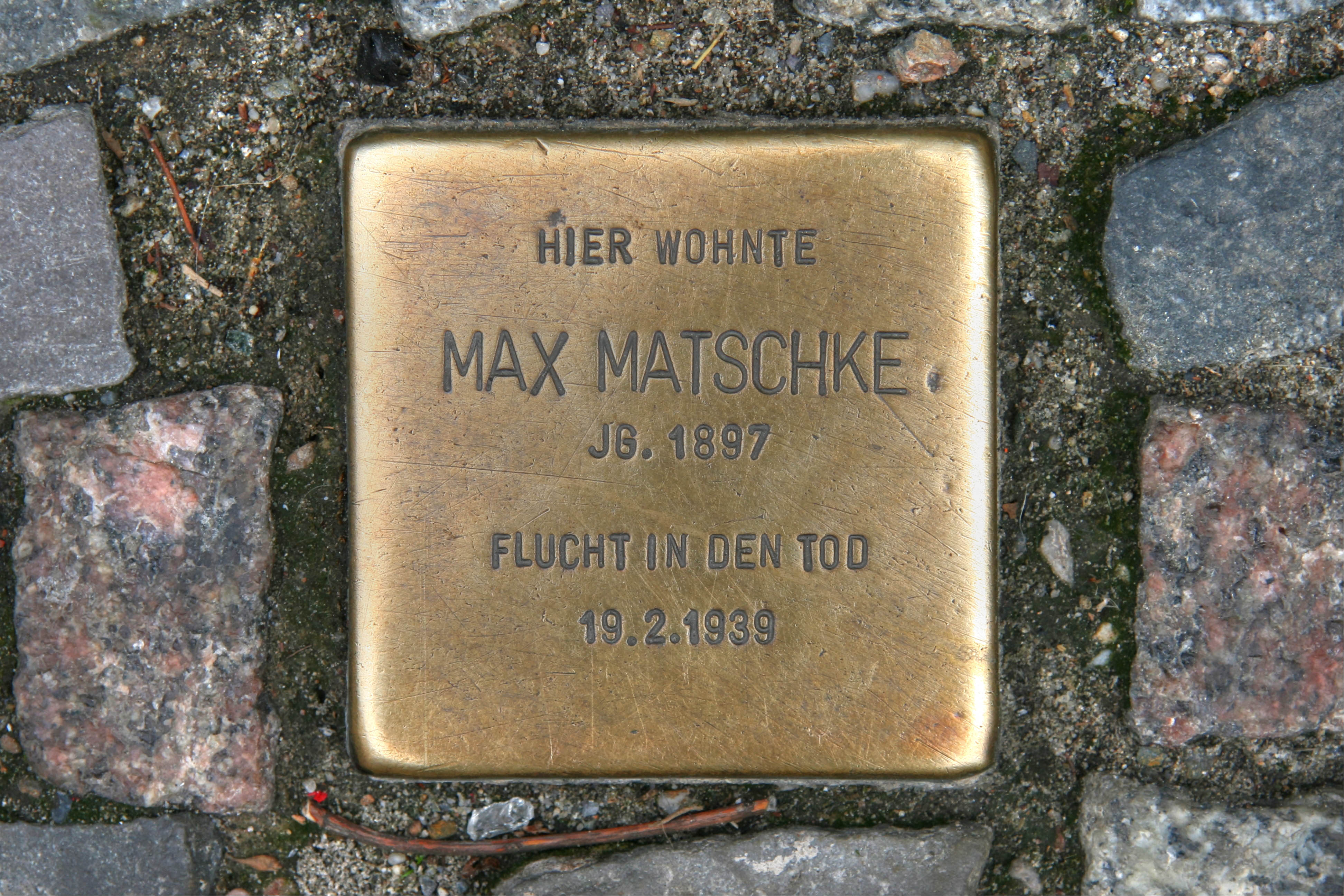
The manner that they interrupt the attention of passersby from the ground, demanding some attention and significance, break up the pavement’s monotony–and the monotony of one’s walk, in intentionally arresting ways. While Musil was writing in the act of pondering the ability of people to understand the events through which they live, the act of these stoperstein are an attempt to turn back and refuse a collective amnesia.

The placement of those marker redressed an intentional attempt to obliterate the place occupied by deported victims of the state, to strive come to terms with the past at a difficult moment in time: the placement of those stones within the fabric of the city’s paving stones was a belated acknowledgement of their absence, as stumbling stones for perhaps less dramatically buried but similarly lost memories. If those stones interrupt the pavement as if to rise as if from cruelly and tragically repressed collective memory of Berlin to take their place as remnants for current residents, these brass markers seek to give past voices gained poignancy as an interruption of lives, not find the fate of figural monuments consigned to “a sea of oblivion,” and acknowledge their absence from the fabric where they lived and worked, and where their lives were horrifically interrupted, interrupt the city walker.
If there is far less politicized sense of intentional memorialization in these pavers, a sense grew, over the year, that these pavement markers spoke to me, in ways monuments rarely do. Were the dates on these paving stones not similar snapshots of the builders who had signed their work popped out at me from the pavement so inconspicuously? The stolpersteine were placed in the pavement, in permanent brass plates, set apart from the cobbestones of a street or sidewalk, but were an acknowledgement that something paved over and forgotten was a part of the landscape. The hidden work of the pavers emerged from the ground, marking an alternate basis for imagining the spatial relations framed in California, from the 1928 geodetic survey, and the laying out of Berkeley’s streets: both interrupted my walks with a sight of melancholy reflection that made me think outside the current spatialities of infection, and the the historical formation of a sense of place, marked out in the streets.


Thanks for this wide-ranging meditation on our sidewalks. They’re a palimpsest of East Bay history, a diachronous record in constant turnover, that anyone can start to read once they turn their eyes to their feet.
https://oaklandunderfoot.com/
Indeed, it’s hard not to read a story of urban expansion and landcover change. The palimpsest of temporalities is cool to discover. I was amazed to find a Blake and Bilger stamp, as best as I can read of 1909, on my own block. The range of WPA strikes in many neighborhoods from Temescal to Sausal Creek evokes a large effort of local improvement, as well.
Thanks for this wide-ranging meditation on our sidewalks. They’re a palimpsest of East Bay history, a diachronous record in constant turnover, that anyone can start to read once they turn their eyes to their feet.
https://oaklandunderfoot.com/
Thank you! Indeed they are; while inspired by the very local pedestrian walks made mostly in the Lorin and Elmwood, I benefitted a lot from the great online commentary they’ve received.