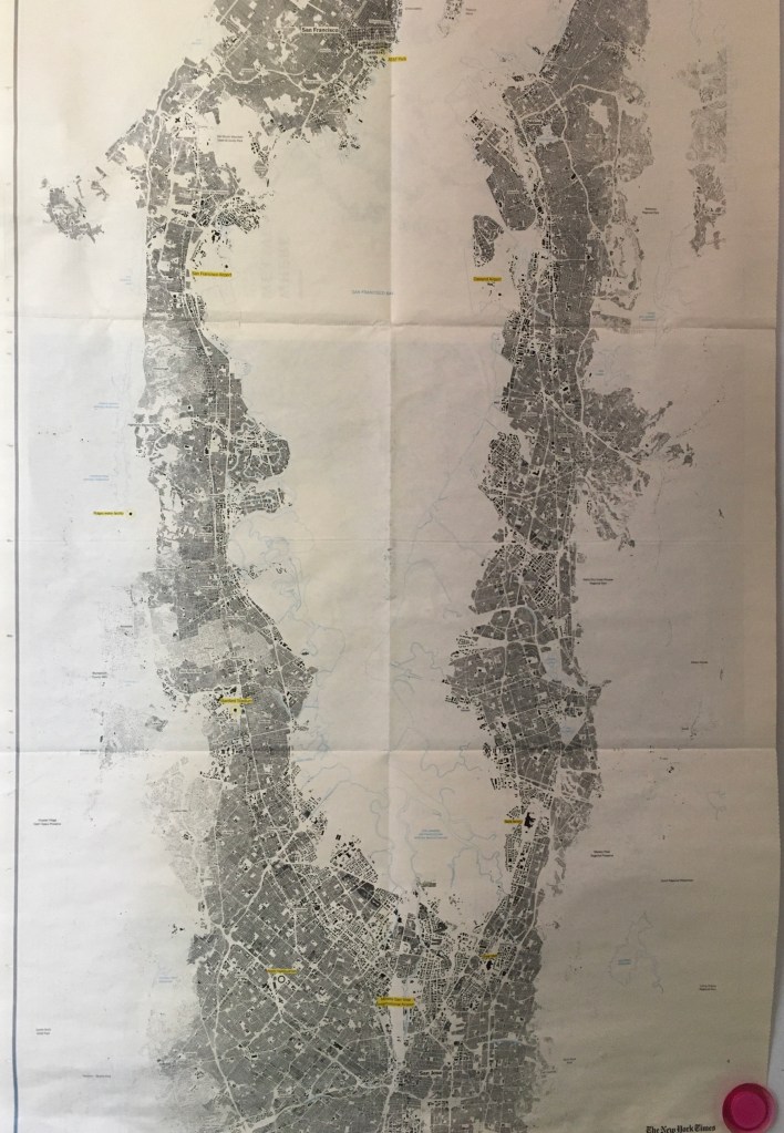
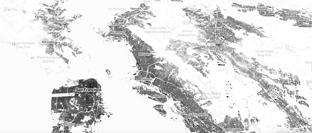
Walking the streets in my now apparently abandoned neighborhood for an errand after a few weeks of sheltering in place in Oakland, I had the eery experience of navigating and inhabiting empty city. While I knew the pavement, I almost felt no longer familiar with the streets that afternoon. There was the sense that no one knew the state of affairs about reopening, and many were just puzzled about how to proceed: as a few young kids skateboarded up Shattuck Avenue, profiting from the lack of cars, some odd improvised bicyclists were on the sidewalk. The absence of interaction was a weird pause indeed, giving an eery sense of the timelessness of space, as if the time/space fabric by which I had long seen the neighborhood was suddenly out of whack. While no visible destruction had happened or occurred, the disembodied nature of the inhabited world was drained, even as it was filled with sunlight and birds, giving me the eery sense I had had when I looked at the machine-read maps of building footprints, “Every Building in the United States,”whose section situating Bay Area buildings hung on our refrigerator wall, like a scary map of the archeological ruins of a future Baedecker Guide to the ruins of San Francsico.
Had the designers of te interactive webmap of machine-readable imagery Microsoft had assembled intended the eery effect of describing the inhabited world as a ghostly ruin of lived life? The relegation to place-names to a very secondary status in the image of the overbuilt landscape seems to lie on the edges of the black blocks of built space that is was the basis for the AI map distilled from aerial photographs, and parsed as black and white data. If its form seems oddly ghostly, the reduction of the monochrome paper map reveals shades of grey that fade into rare open spaces, where one’s visual attention seems at first drawn, before one returns, with hopes for some sense of recognition, to the built spaces that one knows, and the congestion of black that marks urban agglomerations. The black boxes of settlement reveals the crowding of our coasts, the density of much urban housing and indeed of the area of the East Bay where I live, but is also an eerily image of an inhabited landscape selectively organized to omit any sign of living presence–either of “wilderness” or habitat, but anthropocentrically maps the anthropogenic world as if for posterity. For is not the black boxes of building footprints something like a record of the anthropogenic imprint on the world, by now extended across the globe. The building footprint map derived from AI is a rewriting of the ancient notion of the ecumene–the “habitable” more than “inhabited world”–or οἰκουμένη, which sought to encapsulate the inhabited regions as the ones that entered human comprehension: is it a removal of the humanist object of the map, now mediated through machine learning?
If the ancient geographers discussed the οἰκουμένη as the “habitable world” from the frozen north to the scalding sub-equatorial lands that seemed to “balance” the inhabited regions, as if what merited human attention and contemplation was that region that permitted settlement: the turn to a record of imperial administration in the Roman Empire–and of religious unity in a ‘civilized’ world–introduced the governmentality of the control over the inhabited world, that by the Renaissance had become an enticing image of national incorporation and political ties, that became intellectually articulated in the post-Cold War as a global ecumene of imperial cultural dominance and integration incarnated in European inheritance of political institutions, science, technology, and economic forms as a world system: the association of a global integration whose exponent in historical texts was perhaps William McNeill’s Rise of the West (1963) had withered away by the time of the data-driven map of inhabitation, as we have become increasingly aware of mapping the human impact on the world–an image in which the building footprint map might be placed.
It is hard to discuss intentions in a map that was organized by AI, but the ledger size newsprint that covered almost a full side of the refrigerator, hanging on magnets, assembled a flyover of the ruins of a future world, a snapshot of each and every building in the area. The result is a poor excuse for a “wall-map” of the region of Northern California. It seems more of a memento mori of the prosperity Silicon Valley once enjoyed from a future world, registering the intense economic growth that fueled the housing bubble along the San Francisco Bay, in an unintentional snapshot of the explosion of paved space and housing across the coastal margins of what was once one of the more “edgy” areas of the United States: entertaining the imagined future might have created the perverse pleasure of hanging it in my kitchen, long before COVID-19 struck, a celebratory if slightly morose record of the world in which we once lived.
But the sidewalks were empty and sun intense; storefronts often boarded up. The streets were no longer places for salutation or recognition, even if I greeted a familiar mailman on my way home: as if no time for social niceties remained I walked down the sidewalks and into empty streets, rarely negotiating margins of safety, or distancing with a few folks on foot, noticing with a cringe the large number of homeless who stood out against the stark streets, closed storefronts, and empty stores.
They were, as it were, always there. I had been cutting myself off from the surroundings, as I never thought I would. As I had been sheltering, thoughts going global as I was following updates about the pandemic, this was a stone’s through from my home, so many had none. Looking down Adeline Street, at the still tents of homeless encampments that may have multiplied, I felt new distance gaping between us, as the very streets I had walked down regularly seemed to have been forgotten while sheltering indoors, the stores now empty, their windows recently boarded, few driving in the streets where one might walk without danger. The eery absence of population was a scene from The Last Man, momentarily interrupted by an isolated airplane, the first seen in days, flew overhead: I felt like I was on a filmset, more than where I lived, a tracing of life past.
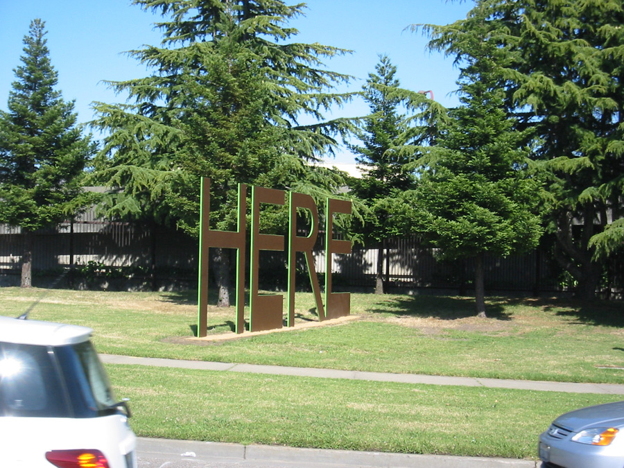
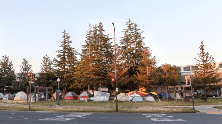
If we were sheltering, what was place, anyways?, I wondered with the footprint map in mind. Empty streets looked like nothing more than an apocalyptic reimagining of the neighborhood, drained of inhabitants, save the apparently increasing cluster of homeless tents, looking far more embattled, and more survivalist than ever. If the building footprint map was restricted to spaces where people lived and work, the ghostly anthropogenic substrate seemed to have an eery counterpart in the homeless encampments near my house. The survivalism was evident in the homeless settlement that had in recent years overflowed, expanding to fill in the island of trees where how Steve Gillman’s 2011 public sculpture marked the interurban divide. The public sculpture elegantly if snidely punned on the allegedly dismissive pity saying ascribed to an icon of modernity about her native home–“There’s no There there“–as an entertainment for motorists, or BART passengers, as much as a public art for pedestrian passersby–by broadcasting a literary reference in greenery.
The two words marked the Oakland-Berkeley border by two words, now rusted fifteen years later, as relics of an earlier epoch themselves: the homeless encampment blurred both sides of the dividing line between the cities which had long since melded indistinguishably in the increasingly gentrifying area where I had lived for twenty-odd years.
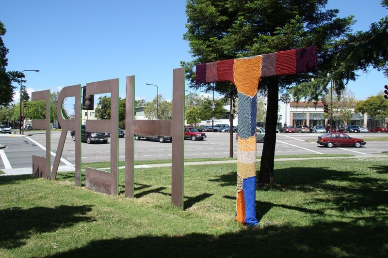
The erasure of a sense of “here” that was promoted by the public sculpture seemed erased in the AI map, that reduced space to built houses, even as the homeless were the only residents in sight as I walked around the tensely empty neighborhood. I’d long appreciated, if a bit begrudgingly, how the Gateway_Project defined the edge of Berkeley CA took Gertrude Stein’s saying and liberalized it in hight-foot tall powder-coated steel letters, where the BART tracks go underground, intended as “a literary and whimsical welcoming to Berkeley,” where they supposedly read not only Stein’s poetry, but where so many poets had lived–and was a “here” worth commemorating by sculptured letters, a new Fons et origo of the Beat Generation, perhaps, or a dynasty of mid-twentieth century poets–Kenneth Rexroth; Czeslaw Milosz; Allen Ginsberg; Gary Snyder; Frank Whalen; Thom Gunn; Robert Hass–by 2002 recognized as a literary patrimony. Designed primarily for passing motorists, as if few could be imagined to walk nearby, the site built to commemorate a “sense of place” had become a cluster of encampments, as if that was the only place that existed at a time when all remained shuttered indoors–if in 2010, just ten years ago, one letter was covered, by a group of Oakland knitters, to transform it to “HERE/HERE,” peacefully protesting the work as barely concealing an agenda of gentrification.
The collective of knitters who had covered the “T” as if to object to the tired trope with which Oakland was long saddled was the result of a. relatively calm tussle, cast as a border war against gentrification. But the global pandemic had subsumed any distinction of “here” and “there” in a new global: the AI map seemed to be indeed a snapshot of the scale of habitation before the pandemic, a ghostly picture of an earlier time.
As I walked through it, at least, the same North Oakland neighborhood was suddenly, if maybe temporary, rendered ghostly: the built landscape that I was inhabiting was the same world, with fewer inhabitants, and less secure attachment to palce–as if the artificial interruption of indoors life shifted my relation to built space, made it harder to navigate, and shifted the security of place, and indeed removed any sense of recognizability from the built landscape, almost to ask what the civilization was that led to the building of all this paved space.
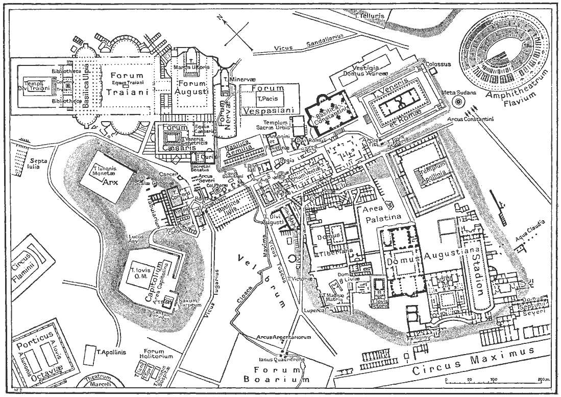
The unmooring from physical presence was like being dropped, I imagined in a flight of fantasy, to that Microsoft map, so akin as a snapshot to the sort of map of archeological ruins future generations might trace as guidelines of orientation to a lost past, when what was the greatest “here” of antiquity–the city of Rome–was etched by nineteenth century archeologists and antiquarians by the physical plant of what once stood on the site of the ancient Roman forum, only perceptible to the eyes of tourists if they had trained themselves on the map to imagine the ghost-like presence of architectural monuments that had once affirmed the place of Rome at the center of the world at a far earlier time.
Where was here, now, on the AI map? Was the tie I was drawing between the map and the uninhabited neighborhood only the depressive meanderings of a middle-aged crisis? Or was it a global one? West Berkeley and North Oakland had been certainly rendered quite a different place, quite suddenly, and not a comfortable one–still inhabited by ghosts. Stripped of my points of reference or familiarity with my neighborhood, a few dispossessed in the sidewalks, of what wasn’t a nice area of town, I was reminded rather urgently of ongoing part of urban life no longer framed by sounds of traffic, public transport, open businesses and pedestrian sounds, that continued while I was indoors. The degree zero of urban life reminded me of the empty landscape of building footprints that, in a detailed satellite overview that recalled nothing more than the outline of an archeological dig of ancient city, as if drained of motion, and filled with apprehension, in a damn eery way. Was this a pause or a new landscape?
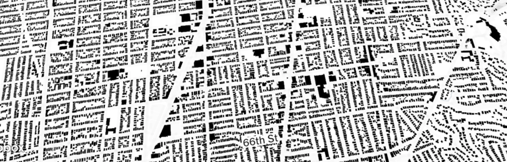
I had only recently been navigating the 2018 building footprint map, “Every Building in the United States,”and aout a year ago, hung the section of the houses of the Bay Area onto our refrigerator wall. The creation of Microsoft that was removed as one might imagine from the ancient notion of an “inhabited world,” comprised of building outlines, a distanced description of the world a declination of mapping human settlements, mediated through what seemed the iconography of an archeological map of a removed time, rather than the actual lay of the land–or, better yet, it seemed to exist in two planes more than ever, and both as a historical record of a snapshot of built space across America, and of actuality. The interactive website of the machine-readable result of aerial imagery that invites one to zoom closely not on landscapes, but a black and white rendering of built space, recalled nothing more than a flyover of the ruins of a future world.
The aerial snapshot of each and every building in its current position had a sci-fi aspect of a record of space drained of nature, biodiversity, non-anthropogenic environments, and life–distilling selectively the extent of built spaces across an otherwise quiet and otherwise uninhabited world: as if the perfect document of the anthropocene, this was the built landscape, removed from and detached from a natural world. This was the built landscape of the region, divorced from the lay of the land, as if a perfection of the GPS contents of street view, without any street traffic or greenspace at all. The stark interactive map of 2018 seemed to be newly present to the space I was negotiating in my mind, even more stripped to its bare bones and evacuate of inhabitants.
The vertiginously uninhabited interactive map peered at onscreen allowed one to look at the nation and soon to whatever spot on the map, suddenly panning and focussing into crisp detail, but lacking all sign of inhabitants, save the names on each street or place. The sense of exploring a neighborhood I once knew may have been an accelerated arrival in late middle age. But the spatially empty landscape of building footprints encountered I opened in 2018, “Map of Every Building in the United States,”was filled with a sense of dread and of testing my own geographical knowledge, scanning to familiar neighborhoods and structure, and matching abilities to recognize the flattened forms against the material structures with which they correlate. There is no sense of the amount of chemical waste and diesel pollutants in the nation’s largest port, Long Beach, pictured in the header to this post, where pollution has caused ongoing health problem for residents.
We now map mega-regions that extend along highways far beyond the former boundaries of cities, along roads and through suburbs increasingly lack clear bounds. The extent of such cities seem oddly appropriate for forms of mapping that seem to lack respect for physical markers of bounds. These maps reflect the experience of their environments as networks more than sites, to be sure. It may be surprising to see the mapping of the ancient world as a similar network, and to try to understand the mobility of the ancient world and Mediterranean in terms of modern tools of mapping travel–that would put NATO to shame, demanded to be studied as mobility research.
–that now provides a way to imagine travel in the pedagogic aids, as well as visual candy, by which we imagine the coextensive nature of an ancient past, mapping travel times, interconnectedness, and flow in the Roman Mediterranean, as if it were a smoothly interconnected network of transit enabling civilization, as varied digital humanities sites from Stanford to Europe assure us.
To privileged flow echoes the absent edges we have lost in our global mapping, tied to globalization, as William Rankin and others argue, more tightly that we are still unaware. Using algorithms to render overland flows of mobility that converged on the city of Rome in the ancient world may mix more metaphors and tools to digitize the past in distorting ways. These are uncanny resemblances to the maps in which we live, as much as told of the past, if they are used in heuristic ways: tracing the spatial extension of extra-urban areas along distended networks of paved space suggests not only a conquest of the antique, but its transcendence, mapping ties within as well as to an ancient world. The analogical nature that Freud gave the expertise of archeology staked out the claims he made for a new science firmly planted in objectivity of a personal past, by a powerful conflation of the personal past with the objectivity of sedimented layers of time.
If Freud understood the self as able to be revealed as a sort of substrate created by interactions of instincts and society, of which the psyche was the result, archeology provided a metaphor, but also a model for excavation and for storytelling to understood psyche as an objective map. And if we are coming to acknowledge not only that archeology was a guiding metaphor for Friedrich Nietzsche that Freud adopted and embraced in his explorations of the psychic traces of personal pasts, in concrete terms that were more rooted to the tie between seeing and saying in their works–and in the therapeutic cure–that explored a terrain hardly able to be seen as transcendent, so much as excavating deep labyrinths in the psyche. For Nietzsche’s use of archeology as a metaphor of knowledge was more rooted in the visual and the concrete helped Freud focus on the “trace” as part of an artifact through the maps he had encountered of the physical situation of a past in Rome, in ways that he was able to transpose so creatively to the physical sites of the psyche not only in the human brain, but in the textures of memory that were, for Freud, quite compellingly concrete.
For Freud’s maps of memory are hardly transcendent, but relied on archeological maps that recuperate the detail of the local, and are hardly able to transcend the suffering or traumatic, or imagine space in algorithmic contours but ones deeply specific and self-made: whose contours and specific way stations are able to be narrativized in telling, and are explored as they are retold with attention to their imagery, psychic and remembered, and unable to transcend individual experience They play with the immediacy of the remote, and the delivery of a past into a tactile present, that was mediated by archeological maps, however, and a sense of the accessibility of a lost past, or past thought lost, that the fantasy of archeology allowed, an ability to shift between temporal registers at the same with a dexterity that the analyst claimed his won special sleight of hand if not intellectual property, rooted in the specific and concrete detail in the psychic past but able to be narrativized as objective discovery in the privileged studio from the layers of narrative and words of the analysand.
1. If the metaphor of the historical map paralleled with uncanny temporal precision in twenty-seven sheets of the Palestine Exploration Fund’s gambit to illustrate the Old Testament as collective history, the map of Rome became the most famous typos for excavating a personal, rather than the maps of Old Testament History that even presumed to detail the prophetic divisions of Ezekiel. Freud had higher aspirations, far more removed from religious divination or airs of prophecy. He eagerly affirmed the task that faced “great discoveries are made by the great discoverers” on New Years Day 1886, as he pondered questions of nerve pathologies that might be allowed by indulging in cocaine, as doors of consciousness, that affirms the scale of his desire for still deeper discoveries. He late rued it as his “fate to discover only the obvious: that children have sexual feelings, which every nursemaid knows; and that night dreams are just as much wish fulfillment as day dreams,” he had claimed his “discovery” of the infant attachment to its mother in 1931 as fundamentally important to world-view that it paralleled “the [recent] discovery of [the 4,000 year old] Minoan-Mycenaean civilization behind that of Greece,” by Sir Arthur Evans had heralded, readily coopting the interest in recovering “vestiges” of psychic attachment and trauma in the human mind in archeological terms. While the milky grey matter resists a road map of intertwined nerves, veins and arteries that nest in musculature around bones.
Freud claimed to have been prevented from his own profession aspirations to be a surgeon as “anti-semitism had closed those ranks . . . to the point where they kept the Jews out.” But the deep concerns he voiced about forsaking his professional vision for himself were in part met by the identity of an archeologist, a compelling figure and metaphor for individuating traumatic memory and healing: he represented himself in the trenches of archeology, as a sort of purified version of his excavation of emotions, rather than raking through the psychosexual muck. If Freud has been cast as a crypto-biologist, a modernist, a fabulist, a detective, the inventor of the dynamics of psychology, and as a hopeless positivist, the figure of the archeologist, one might suggest, capacious to hold all these roles and historicize them in ways that suggest a distinctly specific unity,–especially if we remember the modernity of archeology as a science. For Freud was ready to see symptoms as able to be excavated as psychological strata through the process of analysis.
While this might be traced to the excavation of primal emotions in the fifth century BC archeological statues of Pheidias, revealed in the terror in the bulging eyes, flaring nostrils and gaping jaw of a single horse of a chariot drawing the Goddess of Night in the Parthenon–
–what Freud called the dream-work opened overlapping memories in the mind that he rendered as the physical plant of a city, a living object that was wrongly seen and regarded as dead. The chariot that carried one of the Moon Goddesses of the Night across the evening sky–Selene, sister of Helios and Zeus, most likely–echoes the intense cathartic shock of the excavation of emotional encounters Freud claims that the surface of dreams allowed him to work with his patient to extract.
The figure of archeological discovery both purified and monumentalized his discoveries. They figure of the archeologists not only lent status to his new profession but the analogy exaggerated the objectivity of his discoveries and purified them in objective form. His discovery of the oedipus complex, dated to October, 1897, was described an alarmingly definite moment of realization, and later intimations of future discoveries filled his notebooks and diaries in ways that have assumed an epochal character of a new topographic landscape of a world submerged in the individual mind. Even as Freud moved from physiological interpretations to hermeneutic interpretations, figures of cartography and the archeologic status of maps were metaphors that dignified “discoveries” of infantile sexuality, Oedipus complex, or keys to dream-interpretation heralded to be of the same rank “as a genuine ancient discovery” (SE I: 263). These discoveries were, he increasingly came to believe, a “royal road to the unconscious,” in a figural construct modeled on networks of Roman roads built for to facilitate the transit and transportation, a figural basis for future discoveries?
Freud rewrote the language of discovery–and scientific discovery–from positive perceptions by locating insight in recovery of the “memory trace” by remapping the human psyche as tangible landmarks recovered from lost sedimentary strata with considerable flair. Did not the recent inscribing the name of the father of psychoanalyst on a neoclassical facade of an abandoned church in Oxford, England not exploit the conceit of an ancient temple as a doorway for the initiated?
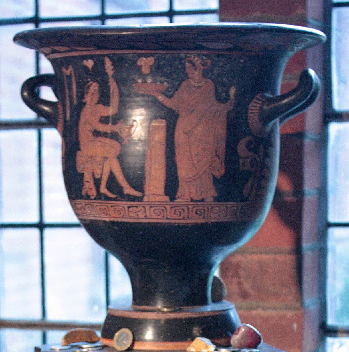
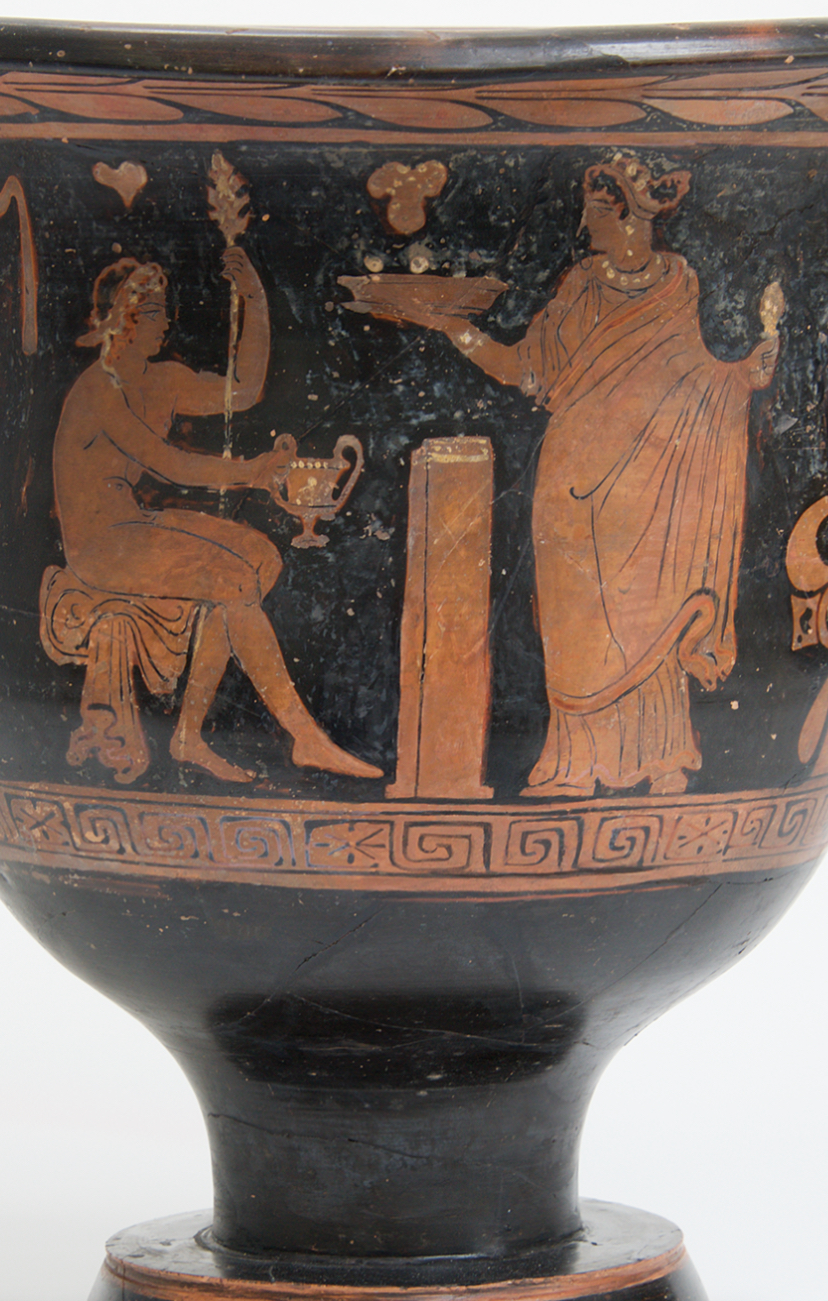
Freud’s passion for the totemic role of archeological antiquities as aestheticized objects was perhaps not the sold reason his aristocratic student Marie Bonaparte gifted him a red-figure vase of the ancient God Dionysius that had been recently excavated from grounds in the south of Italy. The valuable urn was long displayed in his office, winning a privileged place among the two thousand of antiquities in his own personal , echoed the deep analogical role of archeological excavation in Freud’s thought, confirmed to some extent by how Bonaparte’s telling gifting of the urn came to be selected as the final resting place for his ashes in Guilder’s Green–a sort of pilgrimage site holding the ashes of Freud and his wife, the former Martha Bernays; the vessel where the family placed his cremated ashes would have situated his place in a clear intellectual pedigree of excavating lost pasts intertwined with a sexual psyche, but seemed a sort of assumption of identity as a pilgrimage site from 1939, removed from Jewish funerary rites or custom, in the ancient context of the offering to a god. Freud was long respectful of “Princess Marie”–as he called her, assuring his grandson she would be his own “first patron” of art, and gifting her the first sculptures Lucien Freud made in art school, the exchange of objects was heavily charged. The archeological analogies of antiquities consolidated his own cultural status in a self-made field he sought to invent.
The image of an enthroned Dionysus, god of regeneration, fertility, ecstatic transport, and insanity, relaxing with a caduceus like staff, wreathed with laurels, was entertaining a maenad, a fanatical female follower, in a slightly perverse token of the reverence Bonaparte felt for her teacher, lay among the Egyptian and Roman funeral urns that he had collected with a passion, and while no funeral mask was made of the psychoanalyst who cheek had physically degenerated, that image of regeneration seemed apt.
But they offered a far more pervasive basis to map the psychical world in ways that a surgeon might never be able to attain by their simpler instruments and tools. For they cast claims of pschyoanalytic insight as finds by far more than an analogy, as many note; the power of the map of an excavation is less appreciated as a claim for objectivity at the culmination of an Enlightenment inquiry, however, joining materia medica with art in a sleight of hand. The “royal road” to the unconscious Freud claimed to offer was a rhetorical reconstruction o the psychic formation of the subject not nearly as tangible as a cultural tour of Italy in a Grand Tour of historical monuments, but situated in the cultural aesthetic formation that linked archeological expertise to the individual mind, and resonated with the archeological maps of the Roman ruins of ancient cities quickly adopted as forms of building on Viennese and Central Europeans walls as descriptions that were iconic signs of their intellectual pedigree as mirrors of their own cultural stature and prestige. The analogical argument located heightened intellectual transport of the uncovering psychical layers as a fixed topographic terrain of archeological finds,—akin to how Poole’s famous Historical Atlas of the Roman Empire. Archeology, as much as neurology, offered convincing criteria for Freud to pronounce the terrain of his discovery, beyond any interest in therapeutic judgement.
Reginald Stuart Poole, Romanum Imperium (1896-1902)
To affirm his discoveries Freud wanted–or needed–such a detailed analogical map. Only it was able to offer a sufficiently powerful rhetorical figure of sorts able to announce and lend status to truly major discoveries, and he was, by extension, a great man. As the ancient world was mapped in the late nineteenth century of the archeologist, numismatist and orientalist Reginald Stuart Poole’s tracing of the boundaries of the Roman Empire and other antiquarians raised hopes of rendering the discovery of a submerged roadways materially present across Europe, the recovery of the pasts present in the individual mind was similarly explained by the superimposed fabrics of past selves–akin to the Palestine Exploration Fund’s own public relations campaign by detailed maps.
2. Was not the fiction of a historical atlas a powerful way to recast the materiality of past experience in familiar scientific terms? The hopes for remapping the underground network of identity was present in the extent of ancient stone aqueducts, eleven of which fed Rome and a network feeding the Bay of Naples, that brought water to cities’ public baths, and the public roads of the empire on which messengers, couriers, and soldiers traveled, the palimpsestic network of Roman roads that appeared both a civilization of space and empire. It was indeed an organic substrata of civilization, and the organization of urban space of Rome offered a concrete figures Sigmund Freud seized with eagerness as a rational basis basis to describe and monumentalize the material presence to the mind of an individual’s past. Freud’s adoption of such powerful figures of speech for his own discoveries benefitted from of a growing concrete relation to urban space perpetuated and broadly reproduced in maps, which themselves mediated a romantic fantasy of securing immediate access to past spaces and to the unity of space, that became central to the construction of a unity of psychic space, if not the uncovering of the engineering and indeed economy of the psyche–and a very physical metaphor of the discovery and “unearthing” of its map.
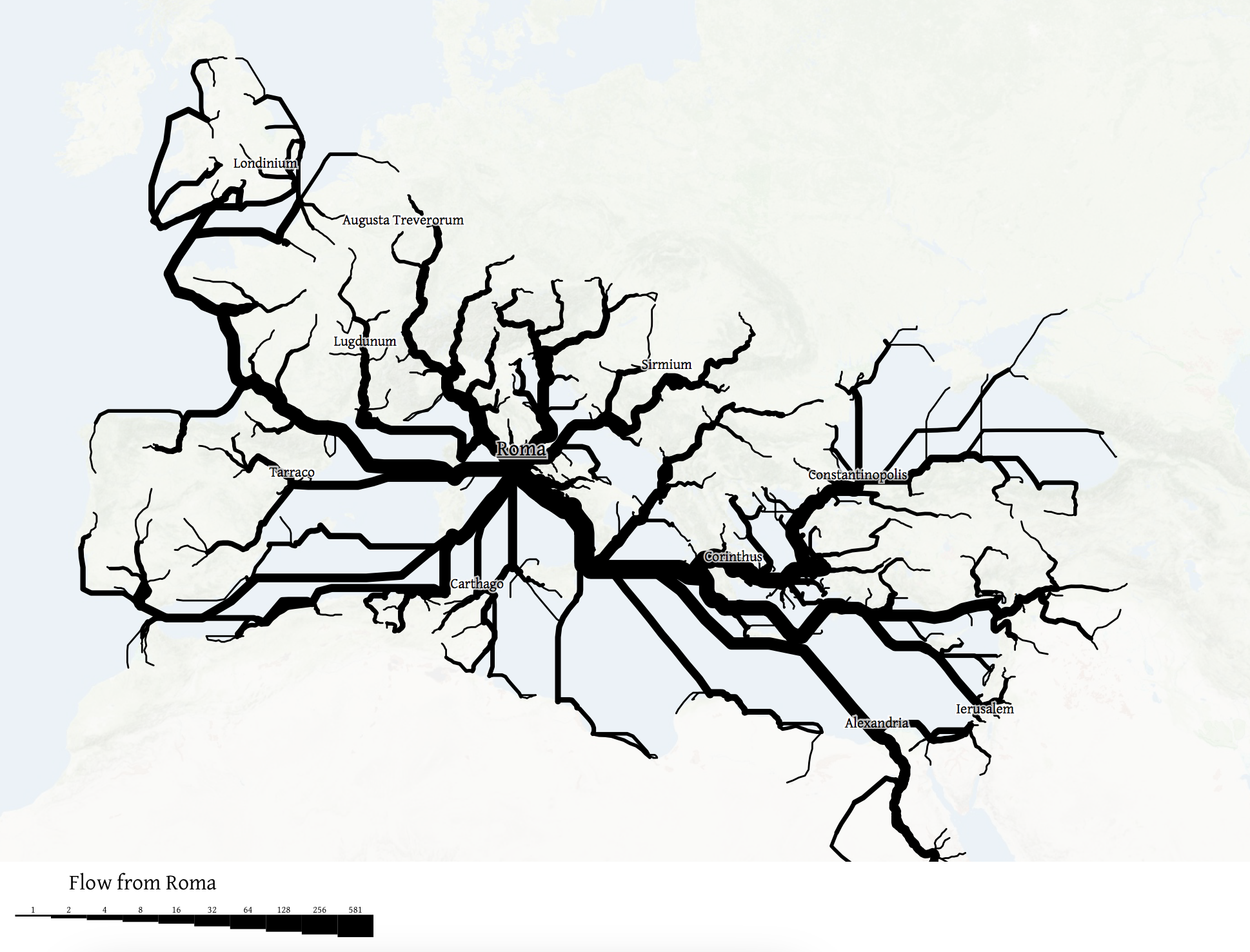
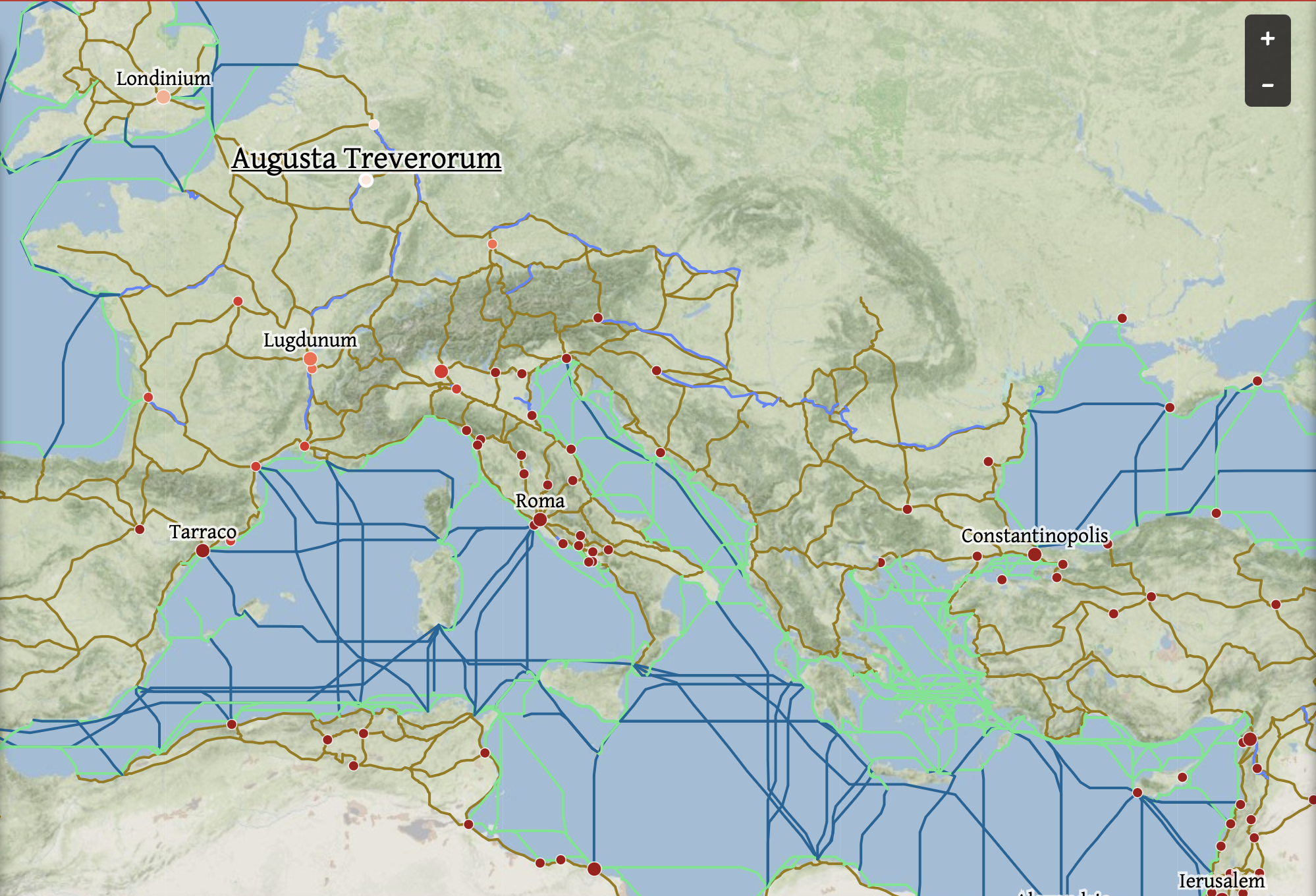
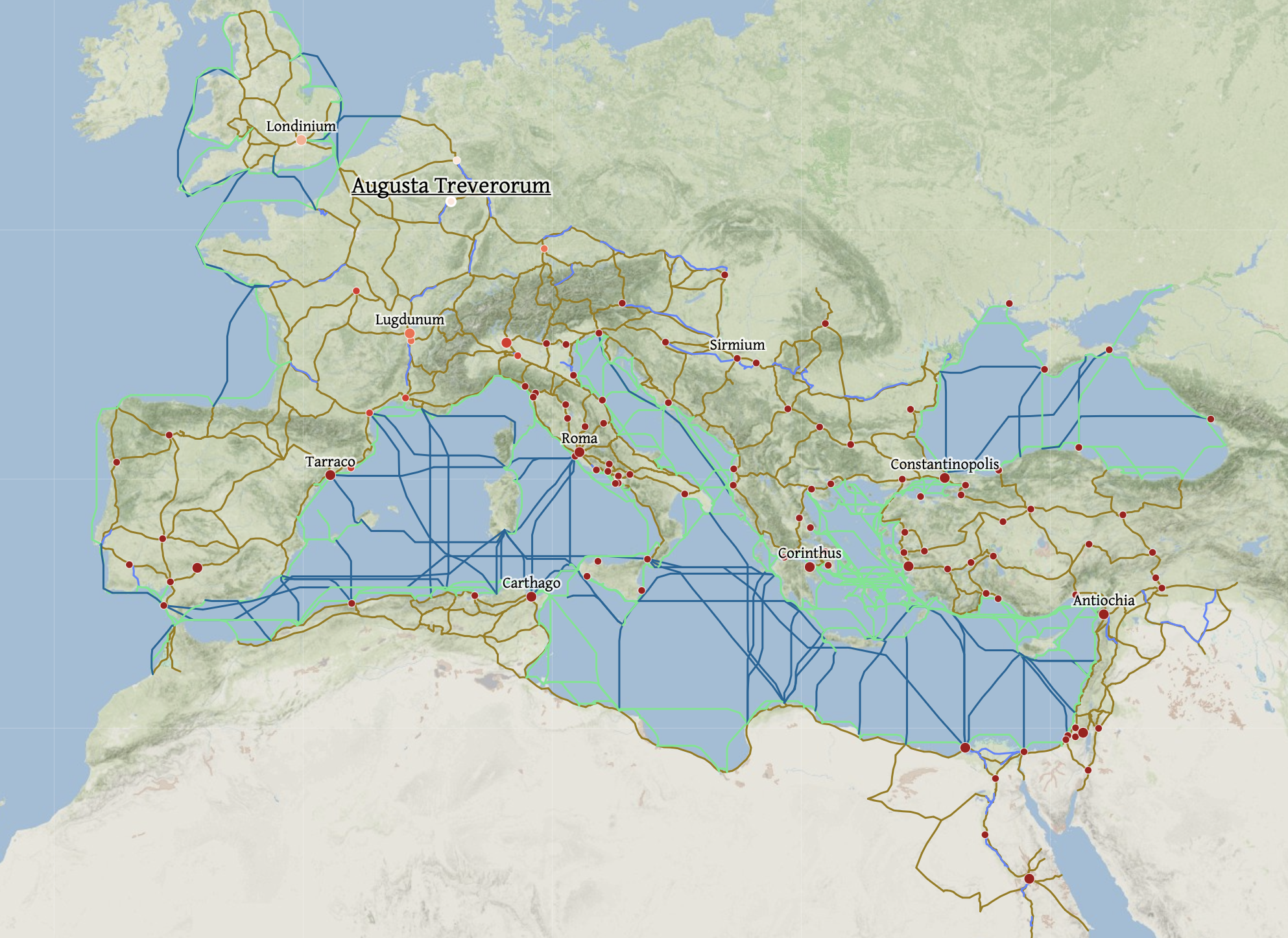
If the totality of Roman roads were mapped from the nineteenth century to the growth of online encyclopedia circa 2000 to concretize ancient history, the role of maps to concretize a relation to the past has since grown exponentially. The network has a new iteration from Stanford’s ORBIS in a brilliant interactive form of mapping Roman roadways–a “GPS for the Roman Empire,” with costs of transport and time of travel included, as an ancient UPS system or FedEx key–to represent important arguments of the spatialities of the ancient world. But the mania of mapping the ancient networking of the Roman Empire as a unity. The maps prompted me to do a deep dive in the materialities of “Rome” that maps have conveyed, hoping to excavate subjective relations to early maps of Rome and perhaps in the virtual interactive web-maps’ geospatial emphasis.
If the demand for mapping the Mediterranean expanse of the Roman Empire is perhaps motivated by deep interests in placing Rome within a global history–a global scope all too evident in the very name of ORBIS and its website–the mapping project offers the different perspective on the ancient world contrast to the competing layers that were long understood as essential in Rome itself.
The current geospatial turn has emphasized the map as a network to plan travel, by seasons, modes of mobility, and route, as if on a modern travel network, projecting flows, nodes, and network, in a conceptualized in unique if not much more graphically embodied than earlier GIS overlays, if offering a dazzling array of ancient options of of mobility on hand–ship, horse, foot, river–and breadth of spatial expanse as a rich board game of open source data from ancient times as much as an invitation to “explore” the ancient world, as Elijah Meeks and Walter Scheidel exhort users.
ORBIS, The Stanford Geospatial Network of the Ancient World, W. Scheidel and E. Meeks
The warping of time evident in recent web maps of the ancient world does a neat double-trick, both s them from historical time and erasing the complex techniques of reconstructing past space. But the relation to travel networks is predominantly flat, as if spatiality exists in an easy translation or iterability of online resources, using the Google template–or other online networks–as a matrix for antiquity.
Rather than the painstaking assembly of a familiar palimpsestic relation to known space, the ancient roads of Roman Empire are converted to a known space, akin to a known world, whose routes open up to us as if a space for walking. There is a disturbing loss of all complexity of processing time and space, in these graphic analogues of the medieval precept, “All roads lead to Rome,” literally ‘”mille viae ducunt homines per saecula Romam [a thousand roads lead men forever to Rome]” as Alain of Lille had it in 1175, in his Liber Parabolarum, have long merited data visualization, so present are they in the collective European unconsciousness. (That they would flow through Denmark, Hamlet’s home, Estonia, and Ukraine, seems perhaps a fitting sort of surprise.)
In tracing the ties of the self through the unconscious, Freud was very clear in an early work: given the incomplete nature of clear records of the unconscious or the past, he worked as a “conscientious archeologist,” not omitting any authentic fragments, and noting the gaps between reconstructions and the “priceless though mutilated relics of antiquity” which it has been the “good fortune” of the archeologist to be a bee to “bring to the light of day after their long burial.” The tie is obvious one, in part, but a deeply poetic act, as well. Freud’s reference to the science of archeology–often seen as a means of legitimization of psychoanalysis as a discursive project of investigation, apart from purely poetic framing, elevating the level of science of neurology to the epistemic plateaux of archeology to manufacture or support its claims to rigorous certainty.
3. In the years when Freud was fresh from the coining of the term “psycho-analysis” in 1896 in Vienna, a plumbing of the mind, seeking prestige for the term and the therapeutic practice mirrored Freud’s interest in collecting antiquities. He was both drawn perhaps to the assembly of fragments as central forms of reconstructing knowledge, defining both the status and ethical quandaries posed by his claims to be mapping the human mind. The etiological hope to “elucidate,” “reawaken,” or “reveal” personal histories about which patients had “no inkling of the the causal connection between [submerged memories] and the pathological phenomenon” was to be “exposed . . . in a most precise and convincing manner,” as Freud and Breuer wrote triumphantly in 1895, as if convinced they uncovered the “pathogenesis of hysteria as a source of psychic traumas, even as they promised to “refrain from publishing those observations which savored strongly of sex.” To chart repression of past sexual encounters, they aspired to a far more sanitized plane of writing, of which archeological plans provided a model if not a fons et origo. If hypnosis provided the basis for recreating hysterical phenomena, in all their associative relations, Freud’s turn from hypnosis as a revelation of a trauma or repression demanded a new syntax of tools of unveiling and revelation.
For late nineteenth-century archeology was, for many, Freud included, first and foremost a form of mapping, mutilated and buried if the “relics” of antiquity were, and the analogy of mapping as a form of bringing to knowledge, and indeed sharing among readers, as much as the creation of a given dramatic scene or “primal” scene that was repressed, and that the patient might be liberated from in its detailed reconstruction. The freighted sense of psychoanalysis as a new form of mapping, and indeed as a form of cartographic knowledge, indeed jostled with the poetic nature of interpretation in Freud’s works, and deserves to be uncovered and excavated in full.
The learning of Rome, and of archeology, suggested a model both as tied to art and as objective in its referents, but dignified a field of interpretive action of digging for memories, removing them from the muck of their associations or even of the human action of embodied life. But the scalpel-like precision of the archeologist assembling and reassembling fragments to piece together a compelling narrative of a past mystery–as much as plumbing the messiness of sexual memories. The emphasis of Carlo Ginzburg on the reading of clues in the dream-interpretation is perhaps a “paradigm” of study, but was dependent on the visual nature of evidence that allowed Freud to put dream-interpretation on secure footing, positing the individuation of key traumatic memories in dreams or psychic visions as a condensation of meaning in one moment of personal history. (The figure of the Gradiva to which Freud kept returning was an image of the Eleusian mysteries of rebirth: the secrete rites depicted by the dancing Maenads that the figure of Norbert Hannold saw, so crucial to the defining of psycho-analysis as a resolution of neurosis, is from a dancing group of Maenads engaged in the most secret of ancient religious ceremonies, but is taken for the striking figure of an individual woman: is the ancient mysteries, associated with an annual fertility rite and the return of Spring, to which only initiates and priests were allowed to see or participate, and ceremonies of initiation thought to have been accompanied by a psychoactive stimulant. The rites, often reproduced in reliefs, became a basis for Carl Gustav Jung to understand psychoanalytic treatment, long after Freud; as a reconciliation with death, the mysteries suggested a cartharsis Freud was increasingly understanding as a moment of psychic cleansing able to eliminate hysteria by its roots in one’s memory by calling it to conscious awareness. Was this present in the frieze?)
Yet the personal history that Freud sought to elevate by dream-interpretation was doing a lot of lifting, borrowed from the excavation of archaeological diagrams of a collective European past. The pervasive network of roads Roman endures as an overlay of imperial roads, present to most students in the nineteenth-century, whose elusive coherence as an “Orbis Romani” and “Imperium Romanum” was widely studied in cartographic form. From the time of their printing as teaching aids in post-Napoleonic Europe through the emergence of archeological sciences, included the 100,000 km of ancient public roads as the nervous system of its imperial unity, the image of a Europe that was continuous and defined–as much as a network of nations or a puzzle of territorial clusters–provided a new image of the peace at the end of the wars, and of a coherent culture.
Keipert, “Imperium Romanum” 1858, Edinburgh (Courtesy Donald Rumsey Library and Map Collection)
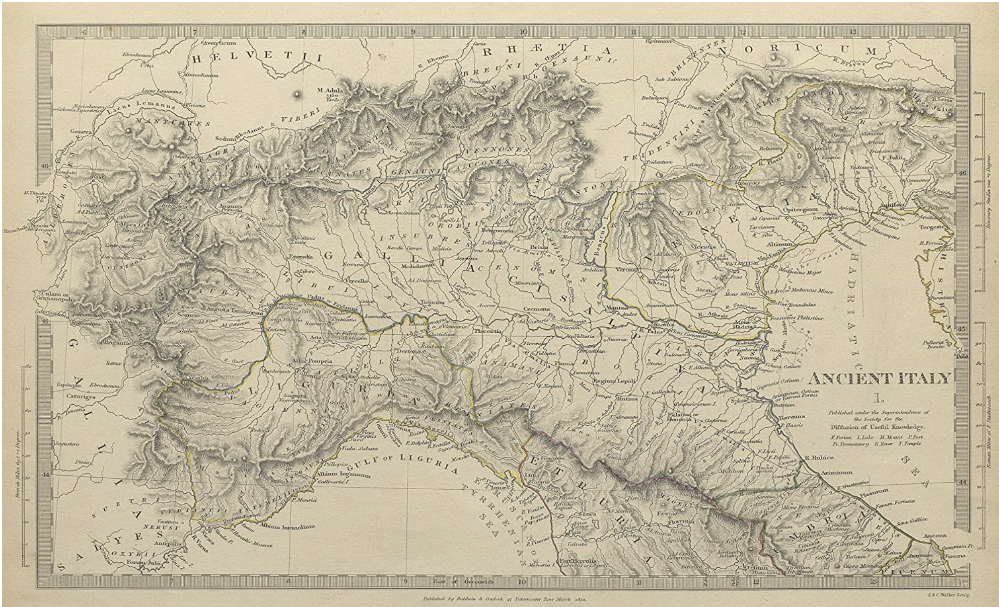
The diffusion from 1844 of a strikingly map of the roman public roads in “Ancient Italy” produced by The Society for the Diffusion of Useful Knowledge may have aided Emerson to treat the road network nothing less than a template of human knowledge, if not a common point of reference for learning, if not for reading works of ancient Roman history.
We may be compelled to apply the same data driven images to ancient Rome, driven due to our own continuing and increased disorientation on the proliferating data maps. But does their logic maintain the complexity of time, space, and place in the ancient world, or how might it better attract interest, by casting the map as a site of investigating not only space, but time? In Ralph Waldo Emerson’s “History,” delivered about 1836, Emerson felt compelled to locate the beginning of the history of man’s relation to nature in the “life is intertwined with whole chain of organic and inorganic being” from the totality of how Rome’s system of “public roads beginning at the Forum [that] proceeded north, south, east, west, to the center of every province of the empire, making each market-town of Persia, Spain and Britain pervious to the soldiers of the capital” as an image of the extension of the individual ties to the world by pathways extending from the human heart.
Ancient Italy, Society for the Diffusion of Useful Knowledge (1832, rep. 1844)
Emerson long preceded Freud, of course, but eerily echoed his points about human psyche when he waxed rather eloquently that as the organic looking map of roads of the Roman Empire, “man is a bundle of relations, a knot of roots, whose flower and fruitage is the world.” Emerson’s notion of the individual as a changed by engagement in nature, and hence always in flux, sharply contrasted to Freud’s famous sedimentary construction of the human psyche in terms borrowed from archeology, but both are searchingly constructed not only in cartographical terms, but in reference to tactile maps of Rome’s past.
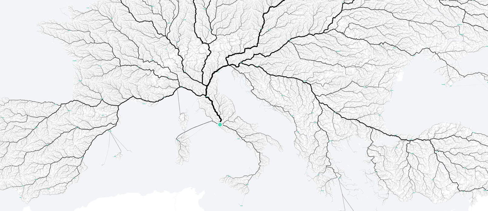
The start of these roads–in the below visualization the light blue point anchoring a record of ancient Rome’s primary routes of travel–marked the Forum, the very site Edward Gibbon claims he conceived the scope and scale of his multi-volume Decline and Fall of the Roman Empire (1776), and, if the point is taken as the city of Rome, where Freud attempted to reprise Emerson in more positivistic terms, in the famous figural description of the temporal layers of personal experience existing as so many archeological strata or laminated sheets of time in the human brain, telling readers they might understand the psyche if they “suppose Rome is not a place where people live, but a psychical entity with a similarly long and rich past,” before, out of frustration, abandoning the metaphor as a way to grasp the interaction of personal history in the mind, before admitting a spatial analogy not able to capture the historical landscape any psychical entity creates.
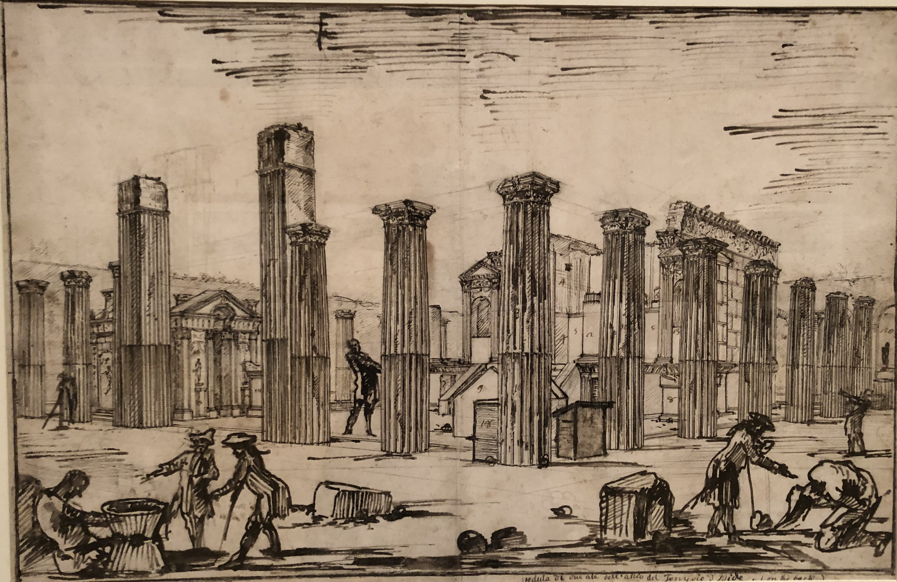
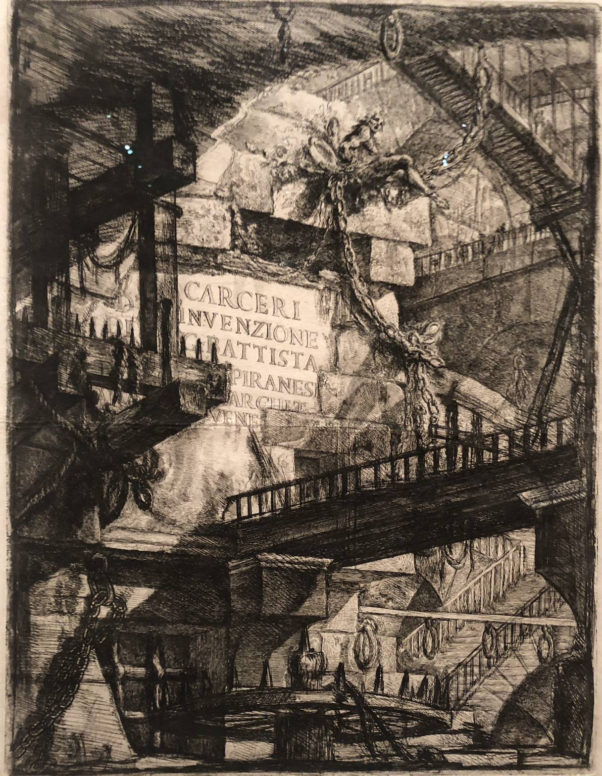
The imagination of Rome as a “universal past” may be deemed overly Eurocentric and dated today, but the cartographic origins of Freud’s hopes for promoting access to the multi-planar or multi-dimensional nature of psychic realities have been less grasped as a model not only of universality, but of the legibility that maps claim to provide, untangling a network not only of roads but allowing the eye to untangle historical periods, by a palpable relation of the past. The image of access to the past through its material structures was offered nowhere more than in the engravings of the architect artist who oversaw the excavation of Pompeii–Giovanni Battista Piranesi, architect and archeologist as well as accomplished draftsman. Piranesi was involved rooted in the esteem of archeological investigations, whose artistic cartography became a guide to the ruins of Rome’s classical world. Venetian-born, his virtuosity became Rome’s perpetual touristic visual guide, who had oriented Enlightenment Europe to its ruins, unveiling the hidden pasts eighteenth-century Enlightened tourists looked to orient themselves to Rome. If Piranesi began exploring the cavernous monumental ruins of Rome soon after he was –working to realize Clement VIII’s program of a new classicized monumental architecture of the Lateran church and other cathedrals–only to end his career designing imaginary prisons whose cavernous interiors invention had a darkness perhaps with other metaphorical parallels to Freud’s excavation of the unconscious.
But that is another story, less tied to the architecture of the ancient world, more to the monstrosity of modernity than the archeology of the past, or the pastness of the past. If Piranesi in the 1770s captured the astounding recovery of Pompeii’s Temple of Isis with an unimaginable materiality of a recovery of the past, akin to a time portal–the ruins of the Temple were European-wide phenomena of a physical, tactile recovery of Roman ruins seen mostly as fragments after their archeological discovery in t1760s–spaces to navigate and explore among erudite and learned voyagers, akin to the entrance into another world by an unimagined or unimaginable portal, whose drawing sought to capture the astounding contact with a lost past era–
–Piranesi would only later turn, as Freud turned to the prison of consciousness, to the terrifying recovery of the prison ruins of his later invention late in his career as a prolific draftsman of the uncanny the are able to be taken as illustrations of the psychosocial prisons of modernity.
Perhaps Piranesi’s actively broad reflection on the imagining and imaging of Rome’s pasts was born out of the attempt to map the network of travel from and to Rome. The success of mapping the distances of travel from Rome on Roman roads, that might have some power as an organic material manifestation not only of the past, but of the Emersonian idea for seeing the roads of Rome as a master metaphor for man’s relation to nature or to the natural world–but raises questions of the deep power not of Rome’s universality, but the power with which cartographic attention has so valiantly attempted to use its tools to untangle Rome’s pasts.
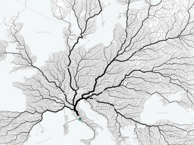
Moovel Labs, 2019
Despite the limitations of their coverage of space, and the limited benefits of imagining the ability to measure times of travel or distances to monuments as a record of ancient space or Roman life, it is tempting to be satisfied with placing it in a network. For to do so offers a way of envisioning ancient Rome as a mega-city and hub of transit. But the erasure that this brings in humanistic experience of the map is striking. If we now move to Rome on paved roadways with utter facility and ease, the sense of unpacking Rome’s significance in the European landscape–or its significance in time–seems washed away in the data map, as if the historical significance of what was once understood not only as a historical center, or center of cultural ties, but the focus of a network of paved roads that united the Roman Empire is all but erased, and is now only an example of the visualization of urban mobility, and of a time when all roads might lead to a privileged city–Rome. There is something suspicious utopic at foot, if also something visually entrancing.
The risk of a loss of materiality is steep: for we seem to lose a sense of the presence of the map of the city, visualizing the distances of travel, costs of economic transit, and time of travel in a web of commercial exchange we both project back our own sense of disorientation. When we use modern notions such as that of the urban mobility fingerprint as the folks at Moovel labs did in concretely visualizing the medieval saying that “all roads lead to Rome” in its project of mapping distances from the ancient city, we run the risk of insisting on the transparency of data, reducing maps and the pattern of mapping to a substrate of spatial relations sufficient in an almost ahistorical sense, and risk asserting the authority of an app over material processes of building and mapping Rome across time.
We read more maps than ever before, and rely on maps to process and embody information that seems increasingly intangible by nature. But we define coherence in maps all too readily, without the skepticism that might be offered by an ethics of reading maps that we all to readily consult and devour. Paradoxically, the map, which long established a centering means to understand geographical information, has become regarded uncritically. As we rely on maps to organize our changing relation to space, do we need to be more conscious of how they preset information? While it is meant to be entertaining, this blog examines the construction of map as an argument, and proposition, to explore what the ethics of mapping might be. It's a labor of love; any support readers can offer is appreciated!


