All maps are simplifications. Cautionary words of the section on “Map Data” in the introduction to a 1986 edition of the near-canonic Goode’s World Atlas advise cartographers to find some way to best select objects or information worthy of representing, evaluate their relative importance, and “find some way to simplify their form.” The statement acknowledges the risks in any mapping, of which Goode himself was aware, and aims the mapmaker toward crafting a disinterested map. Then comes the barbed disclaimer: “Because a well-drawn map creates an aura of truth and exactness, the cartographer should caution the reader against interpreting the generalized data too literally,” cautions the introduction. The problem was the distortions that maps created; in the first atlas that he printed, Goode had questioned the format of straight parallels and meridians that intersected perpendicularly for compromised its relative accuracy, or for presenting an untrustworthy image of terrestrial relations.
The American geographer John Paul Goode (1862-1933) directed considerably attention to the failure of the reliance on perpendicular parallels and meridians in Mercator’s projection, and the distortions of relative national size and, more broadly, geographic interest this created: Goode’s attack on the geometric distortion of the map was a recurrent theme of his public lectures, and when he decided to organize a new educational atlas from 1908, he designed his work to offer a new sort of educational tool for encouraging interest in geography. His hostility to the Mercator projection, despite its considerable artifice, was a basis for designing the world map for this atlas: in promising to introduce a new format of terrestrial projection before the congress of American Geographers’ Association that year, he condemned the Flemish cartographer’s 1569 cylindrical projection as “evil” and promised a new format of terrestrial projection be used in American schools to train students in world geography in ways that he felt were inadequately served by the many distortions created by “mapping” the earth onto an imaginary cylinder around the earth, as Mercator had proposed in the most famous of the several world maps he designed.
“Frequently,” Denis Wood enjoined readers,”[cartographers] do not mean what they say, they rarely practice what they preach, and have managed to order their maps to preserve to preserve the implications of transparency for the general reference section,” as if suggesting that half of the game was to persuade readers. Mercator did not try to assert transparency for his projection, but provided extensive explanations of both its mathematical construction and distortions of the poles in framed legends, if he did not admit that the map became untrustworthy beyond 70 degrees on each side of the equator line.
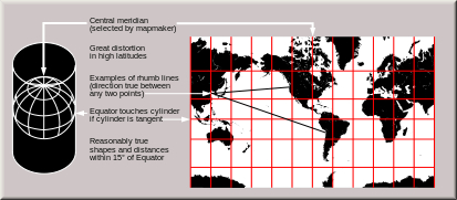
When Goode tilted his lance against Mercator‘s 1569 projection, he objected to the misleading viewers by organizing parallels and meridians in perpendicular relation to one another. The map effectively expanded northern regions of the world, as the then-iced-over Greenland and Antarctica as a result. The cylindrical projection rectilinear graticule of parallels and meridians resembled a geometric grid–a notion, while clearly flawed, provided a compelling basis for Mercator to straighten the rhumb lines of nautical maps, and integrate information from nautical cartography to a world map. The flaws in the projection were known: even ancient geographers had debated the uses of such a rectilinear grid, and found it discounted terrestrial curvature. Mercator however returned to this ancient form as a way to map straight lines of nautical travel on the map’s surface, adjusting its form to accommodate nautical maps by allowing distances between lines of latitude to increase as one moved north or south from the equator. His innovation was to maintain a perpendicular relation between meridians of longitude to parallels of latitude–as they are on the surface of the earth–at each point on this projection, which allowed local relationships to preserve accuracy.
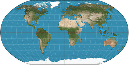
The result did not sit well with the pragmatic ends of instruction Goode desired. Goode vociferously attacked the faults of the Flemish cartographer’s cylindrical projection as perpetuating cartographical errors. He believed that its idealized had long deflected criticisms of their accuracy and distortions. Its errors lay not so much because the projection privileges the size of Europe–as was later argued–but in how it granted large territorial expanse to Greenland, and did not extend a similar bias toward America suitable for Americans to learn geography. Despite engraving a large projection of the world in sixteen sheets, Mercator never designed his projection to serve as wall-map, akin to those used in to American schoolrooms for geographic study. Mercator, a printer and editor of multiple projections as well as a geographer, and was not committed to one schema of global projection alone that had become identified with his name and authorship. (Mercator himself preferred a curved sinusoidal distribution of the earth, organized around a central meridian, to the cylindrical because of its ability to maintain accurate distances.) But the projection epitomized an inaccuracy and distortion often recognized–as by Goode–to be the cost of any world map. To devise a more legitimate and pedagogic projection for the classroom setting, that school atlases would use as educational tools, Goode fused Homolographic and Sinusoidal projections in a Homolosine Projection in 1916, coining this term and presenting it as a more suitable projection for instruction and the basis for what became known as the “Goode’s World Atlas” for Rand McNally.
The projection not coincidentally restored North America to prominence in the first sector of its flattened orange-peel segments.

This iconic map, prefiguring the corporate logo of Trans World Airlines, used decidedly wavy meridians to remind his readers of the equatorial bulge in the round surface of the world, and make clear its transformation of a curved world, rather than–as Mercator–transposing round surface to “spread on a plane the surface of a sphere” for readers. The map explicitly showed students a picture that affirmed the world’s spherical nature, as if lest anyone be led to believe that it was flat.
Goode affirmed the advantages of this teaching model in many public lectures that he gave through the country. Goode believed that despite giving the appearance of accuracy and regularity of its perpendicular parallels and meridians to readers trained in geometric graphing and Euclidean geometry, the map was pernicious. In dedicating his career as a geographer and educator to “to making geography a simpler and more enjoyable subject to learn” he started from the map itself. As well as a productive cartographer, Goode was a proselytizer of the benefits of truth in mapping; as the power behind the Rand McNally Atlas, and a tireless advocate of the benefits of atlases in education, as well as the teacher of an entire generation of American geographers.
The Mercator projection did not sit well with his insistence on a pragmatic value for maps. These concerns might be likened to John Dewey‘s interest in both transparency and logical relations. Dewey in fact dwelled a bit on the “Mercator projection” that Goode detested briefly when he investigated the relation between a country and its map in writings on mathematical discourse. John Dewey observed how “the similarity of the relations of the map and those of the country is the product of taking maps that have in fact been perfected through performance of regulated operations of surveying in isolation from the operations by which the map was constructed.” “In the ordinary Mercator map,” he noted, “if the polar regions are taken to be relative . . . to the equatorial regions, “there would be misrepresentation.” He observed with rue that “there is a morphological enlargement of polar regions in the Mercator style of map; in the cylindrical, their shape is distorted, while areas are correct . . . when the directive function of the map is left out of consideration it must be said that no map is “true,” not only because of the special ‘distortions’ mentioned but because in any case a map represents a spherical upon a plane surface.” He was intrigued by the system of relations constituted by a map: “In the ordinary Mercator map, if the polar regions were taken to be relative (in the sense defined) to equatorial regions, there would be misrepresentation.” Dewey revealed his concern with the functional relation between country and map, as well as the instrumental role of maps in “such operations as traveling, laying out routes for journeys, following movements of goods and persons,” finding the distortions in the Mercator projection made it lacking on both grounds.
As Goode dedicated his efforts to restore pleasure to studying geography, his attack on the “aura of truth and exactness” of maps hints at the deeply seated nature of Goode’s criticisms of retaining the equiangular projection associated with Gerard Mercator in schools as a guide to world geography–not only did its limited preservation of global accuracy rendered it practically unusable at latitudes above 70˚ but the map provided little relation to an existing political geography or an amenable geopolitical image of terrestrial geography. Mercator’s aim in his 1569 sixteen-sheet map was to present straight lines of sea-travel, or nautical course, rather than preserving terrestrial proportion, transforming East-West travel so that meridians and parallels were perpendicular, and “linear scale” was equal at any point–although uniform scale not maintained. The resulting distortions of “expanse” at latitudes significantly above the equator are clear to observers who noted its perpendicular intersections of meridians of longitude and parallels of latitude:

These distortions are increasingly accurate with the regional surveying of the globe dramatically expanded; Goode would have none of its expansion of Greenland to the size of Africa by the early twentieth century–a result of the projection schema transmitted by applying Mercator’s procedures, more than of Mercator’s original map, whose intent was less directed to terrestrial coverage than reconciling previously opposed standards of nautical and terrestrial cartography.
The harsh condemnation of the misleading “aura of truth and exactness” in maps such as Mercator’s projection is telling, and although it wasn’t written by Goode, continued his cartographical crusade. Although Goode’s deep concern with the use of the projection and geography’s acceptance in school curriculum is understandable, it is curious that the work of a geographer closely associated with the printed maps as Goode sharply condemned the “aura” of truth in maps so sharply. “Aura” here meant the misleading nature of its authority, but also suggested the staying power of the map as an art form, and the way that the artifice of map-making persuaded viewers of an appearance of accuracy and accurate inter-relationships. But it can’t help but recall how Walter Benjamin discussed the lack of aura in printed works of art.
The editor of Goode’s atlas who condemned the “aura” of maps as the Mercator projection was probably unaware of how Benjamin discussed the loss of “aura” of art in an age of mechanical reproduction. For Benjamin, mechanical reproduction had the cost of removing the work of art from a ritual context, and artworks in reproduced form contained a diminished sense of the trace of the hand or the materials of their original construction. This was not entirely a negative process, but an acknowledgment of a fait accompli, for Benjamin. The aura to which Goode’s editor objects might lie, for Mercator’s work, both in the authority of its iconic form that was uncritically transmitted and in Mercator’s hand-engraving of the image–in which he not only combined the most recent nautical cartography. Although we now distinguish Mercator’s projection as a mathematical solution for preserving the Euclidean form of a map and reconciling navigational courses with compass bearings, Mercator’s artifice lay in his practice as a map engraver. His map was fundamentally a description, misunderstood as a mathematical equation, which uniquely synthesized charts and projection and elegantly described both the mathematics of his projection which he pioneered with maps of both poles that the projection did not allow. It created a new “aura” for the printed map, as it were, to allow it to compete with the appearance of discoveries on recent nautical charts.
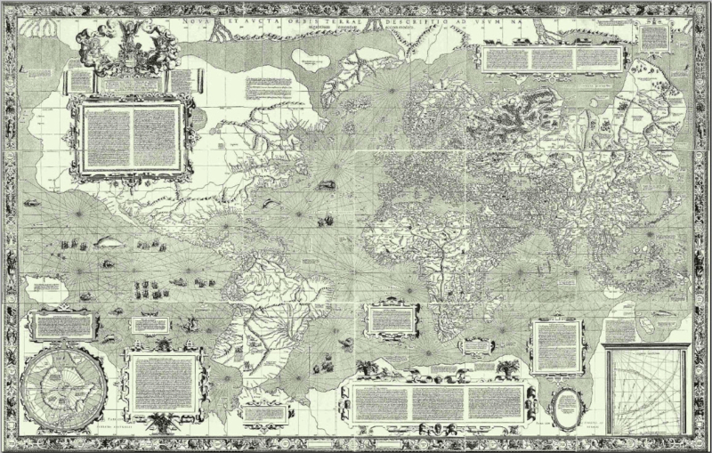
The map he created echoed a tradition of learned humanistic geography, removed from nautical practice, to be sure, but eager to incorporate its practical results, much as the earlier map of the humanist Martin Waldseemüller of Strasbourg, who in 1507 combined recent nautical results from sailors with his considerable geographic learning to treat the map as a medium and forum for illustrating geographic knowledge–boasting that his woodcuts demonstrated the discoveries in Indies and Americas “more truthfully and exactly” than existing maps or charts. The comparison to Waldseemüller’s 1516 Carta Marina is perhaps more telling, since it clearly seems to adopt the growing aura and appeal of manuscript nautical “portolan” charts as bearers of new information; the Carta Marina, distinguishing itself from his global projection, included place-names identical to those that appear in charts executed by the fifteenth-century nautical mapper of the African coast, Grazioso Benincasa of Ancona. It also follows the form of map projection that we associate with Mercator, who likely emulated this map:
Both the cartographer who never left Strassburg, Waldseemüller, and Mercator responded to the growing fashion for nautical charts, and acknowledged their derivation from the genre of nautical mapping to attract new readers. The “aura” of Mercator’s map lies in the revealing role of his hand in synthesizing maps, combining geographic texts, and combining the conventions of noting direction on rhumb lines with the measured spacing of parallels and meridians. Both create a similar engraved image bound by an elegant frame: rather than give prominence to notches that correspond to lines of latitude and longitude, Mercator also painstakingly ‘framed’ the map in an ornate manner, dedicating attention to an elegant banded frame, and including many panels of geographic texts that would reward the sort of careful study that its large form allowed.
Benjamin’s point wasn’t limited to the Luddite’s antipathy to the mechanic. It has continued to provoke new claims of the role of art in an age of reproduction and of reproduced art, indeed, and at least in part came out of his interest in film as a medium: but his observation that printed reproductions of art lacked the “aura” of use-value specific to a work of art was closely tied to the very “aura” that Goode’s editor sought to distinguish his maps from, and of which Mercator was very much a part. For Goode seemed to distance cartography from “artistic” aspects of engraved maps of Mercator’s day, and to assert what might be called the more “logographic” function of map making. Mercator’s projection is not often thought of as aesthetic or artistic, and maps are not often considered works of art. In the manner that it uniformly straightened its bearings to approximate a satisfying equiangular graticule, and is a bit of an esthetic creation of itself: its frame is far more conspicuous than its measured indices.
The artifice of preserving the angles of incidence in the terrestrial graticule, if not the size of land mass framed the world in the form of a framed picture, after all, albeit in engraved form. Although Benjamin’s “aura” seems to exist in the relationship between observers and a work of art. the art of mapping had so dramatically expanded in the world of sixteenth-century engraving that his map was a cognitive achievement of the mathematics of re-distributing space along straightened parallels and uniform meridians. In straightening bearings to recall an equiangular graticule of Euclidean form, in contrast to the curvilinear projections included in many Renaissance editions of Ptolemy’s treatise on world geography, Mercator mapped the world in a satisfying Euclidean space, preserving the angles of incidence in the terrestrial graticule, that invested a new aura in a planisphere as a readable expanse. The projection reduced or omitted the “unknown lands” that earlier cartographers had noted; by directing attention to its indexing the “habitable world,” and limiting regions near the poles, the projection also conveniently restricted its coverage of unknown regions. And it omitted medieval geographic constructs as the Antipodes or Sea Monsters that appeared in earlier maps. In their stead, the projection reconciled conventions to “read” space, and refined a model for imagining and tracking travel through space–even if it was not used on ships for doing so. Unlike a simple nautical projection or ship chart of the sort that existed in manuscript, however, it projects expanse to a indexed matrix.
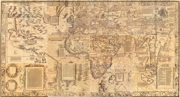
The 1569 edition of the map of sixteen sheets survives in but three examples, yet was a sort of luxury product in itself when it was first sold and sold briskly in the decade after it was devised. The noted meridians and parallels together with the rhumb lines of portolan charts, ordering expanse both on uniform meridians and alternate modes of notating terrestrial expanse on land and water. It lacked prominent notches on its frame, and would probably not be used to read or approximate terrestrial position. It’s often argued Mercator devised the conformal projection for the use of sailors, who could transfer the bearings of rhumb lines on nautical charts to its graticule, since he entitled his “Orbis Terrae Descriptio ad Usum Navigantium Emendate Accomodata” [Description of the Terrestrial Globe Correctly Amended for the Use of Sailors]. The map did not lead sailors to abandon charts, although Mercator identified it as “corrected for the use of sailors.” Its market might have been distinct from sea-goers, however, despite his acknowledgment of the benefits he gained from their findings: the map synthesized the results of navigation through his artifice in a new comprehensive image readily read by landlubbers more than for the use of those at sea–constraints in taking accurate compass bearings at sea made it less trustworthy at sea, Mercator would have known. By synthesizing results from Spanish and Portuguese charts, he sought crafted another way of framing the individual reader’s relation to space, by adopting hybrid signs in his map. Although ostensibly made for the use of sailors who could transfer bearings rhumb lines on nautical charts to its graticule, given limited abilities to secure the reliable compass bearings at sea, the map was probably easily read with the aid of a compass by those ashore in an age when compasses were valued commodities and luxury goods. This is was the audience among whom it was most likely viewed. (Partly because of the success as a map as a projection that preserved local scale, it is still retained on Google Earth: it also of course fits nicely into the frame of a computer screen.)
Mercator intended the sixteen sheet projection as a record of global knowledge, capitalizing on the increasing authority of nautical maps. It was something of an encyclopedia, describing the origins of rivers and the world’s seas, and limiting the range of “unknown lands.” In doing so, Mercator presented the map as an autonomous form of comprehensive geographic knowledge in revolutionary ways, framing an argument about an individual relation to space, as it were, and construing an individual relation to expanse. Stephen S. Hall enjoined we acknowledge the relative nature of all maps recently by noting how, over time, we develop our personal geographies, or “her or his private meridians,” advising“I Mercator; you, Mercator, too”: but Mercator provided a template for a deeply individualistic relation to the totality of known space, by bringing all resources of terrestrial description to bear on the task.
Which brings us back to its aura and artifice. For the projection was successful as a canonic model to transcribe the indexicality of the entire globe–and affirmed a new relation of the reader to the surface of the map. This was Goode’s problem. The persuasiveness of encoding an accurate record of space was exactly what gave Goode suspicions, and which Goode’s editors were keen to perceive. Mercator had in 1569 tacitly asserted his ability to transform expanse to a planisphere that could be read on both rhumb lines or parallels and meridians. He noted that his projection delineated a new model of projection whereby to “spread on a plane the surface of a sphere in such a way that the positions of places shall correspond on all sides with each other;” even though it clearly distorted the size of Greenland and Antarctica, or diminished the expanse of South America and Africa, this was of less concern to his readers or to the readers of sixteenth-century maps: no one was going to stake claim to these lands, for one, and the seas were of greater import than the areas near the poles. The inaccurate presumption that these leaves were used to create a wall map–and an advertisement for global dominance–was only imagined in the late nineteenth century. For a more proportional map of global coverage, Mercator himself preferred a sinusoidal projection.
The power of Mercator’s transformation of space is the relative absence of local distortion due to its conformal construction, giving it a staying power that has continued in different forms through Google’s maps. The means by which it maintained its conformality were Goode’s problem, however, for he saw the map as perpetuating a geopolitical deception outdated in the modern world. One might recall that when Brian Harley sketched the outlines for a history of mapping, he began from how “cartography was [long] primarily a form of political discourse . . . concerned with the maintenance of power.” The staying power of Goode’s map, interestingly, can be roughly tied to the political dominance of America in the “short” twentieth century, or from 1914 to the 1960s, when the Mercator projection was revisited, not only by the German journalist Arno Peters’ equal-area projection. Peters showed sensitivity to the visual construction of maps as forms of propaganda, when he promoted the projection, noting how the map privileged one area over others. But Mercator’s projection had already long been defunct for geographers even before 1961, when Arthur Robinson devised a global projection to map the earth’s surface as a flat image with significantly less distortion than Mercator mapped.