
In very few cases are the associations of place-names so powerfully resonant as in those that derive from a biblical frame of reference: they speak across time, in a powerfully incantatory way, unveiling a sense of space in maps, and claims to that spatial jurisdiction. Palestinians ruefully note that Jews–or Israelis—live in ruins, the myth of their past inhabitation inhabits the present through place-names on a map, and on a scribal map, as it were, that underlies the most sophisticated GPS claims to boundaries: if geopolitical boundaries are determined by hexadecimal coordinates of GPS in current treaties, textbook maps in the Israeli courses of Civics frame the territories won in the 1967 Six-Day War as a historical geography of liberation of lands in the West Bank that fulfill “a return to Judea and Samaria, areas where our patriarchs and matriarchs lived” and “where the Kingdom of David and Solomon was established.” The regions are identified as physical loci of collective memory, and indeed invested with elevated status as places to almost sublime transcendence of contemporary politics as constituting “the heart of the Jewish people,” more than contested lands. Such textbooks that instruct readers that “already in the Bible period, Jews lived in this area, and the Bible . . . this is where the patriarchs and matriarchs were buried,” evoking the lands and boundaries Jews gained as a people set forth in the Book of Numbers not as modern, but confirmation of expansion of the nation’s borders concluding a sacred narrative of the establishment of Biblical era, rather even if it is inhabited by Palestinians.
Such maps fulfill especially pernicious ends in failing to orient Israeli students to the world in which they live. One can find “Judea” and “Samaria” in books of Genesis and Joshua point to the Jewish presence in the region–although I first heard them referred to as places in the current world was when I moved into a condominium in Los Angeles’ Fairfax district, and was told by my neighbor Clara Markowicz that her husband was born in Judea, coming home with cans of goods she requested as I heard, in the stairway, of a region I had to ask as Israeli friend to clarify after I had brought her several bags of groceries in a gesture of neighborliness. The region had a concreteness in her mind as a birthplace, of almost mythic stature; the foundation of settlements that were often military outposts that became residential rapidly expanded as they were established after a pioneering rabbi founded a local yeshiva that seeded the settlement in the collective imaginary on a scriptural foundation that would later gain sovereign status within the rapidly changing arial map of “Israel” as a nation.
Local toponymy is rarely so transparently or so powerfully painted on a cartographical canvas to evoke of narratives of collective memory as in maps of the Holy Land, designed to orient readers to a sacred space, as much as within a territory–and to confirm the elision between past and present by the magical condensation of space that cartographic conventions allow. Although many of the best-known maps of the regions are reconstructions, the location of holy sites as Jerusalem, Bethlehem, Jericho, Caeserea or Mt. Sinai create points of entrance, more powerfully than siting points, for plotting multiple master-narratives across a historical gulf and spanning different epochs; the map is alternately the container and the field, the historical synthesis, but also the screen: Israeli annexation of 40% of the West Bank anticipates how a Trump plan would “turn temporary occupation into permanent occupation” over the land God told Moses would “fall to [the people of Israel] for an inheritance . . . in its full extent” in Numbers 34:2-3, as bounded by the “edge of the Salt Sea on the East.”
The “conceptual map” for “Peace to Prosperity” a vision that Trump issued is proclaimed the “ultimate deal” ensuring sovereign unity of Israel, but proposed a very, very old idea of sovereign boundary lines. It was perhaps encouraged by his own love of borders, the plan pacified evangelical Christians who arrived to be volunteers in settlements and envisioned these new boundaries. Numbers 34:1-10 idealize the very boundaries of Canaan the Lord descibed “as an inheritance” extending to the Dead Sea –“up to the Salt Sea on the East“–as Israel’s territory only expanded to its full extent to the north in the time of King David, rabbis realized Pro-Israel evangelicals, skilled in the territorial visualization and eschatology, deferred questions of residents, wondering at living beside folk not sharing faith and lifestyle in the Holy Land–as strategic allies over the long term. If President Trump would be able to mimic the God-granted boundaries in his “vision” of the State of Israel that annexes land far beyond the current security barrier, and demilitarizes the West Bank by annexing some 40% outright, the sovereign expansion to include all settlements whose legality in international law has been intensely debated for over fifty years, but often reassessed “in light of new realities on the ground.”
The redrawing of the settlements on occupied land would be included in the “greater map” of Israel proposed, which demands interpretation against the deeper symbolic map sketched in Biblical pronouncements, rather than being defined by the new authority of GPS coordinates in international law:

The power of such potent toponymy mark place by offering access to a sacred space, in ways that illustrate the dual deictic functions all maps have of showing or making present and of conjuring narratives. So evocative is the verbal map of the region in scriptures that the map they help to weave and any later maps that respond to this image create a place where time collapses–where the present is poised to dissolve into the past. Current plan s for Israeli annexation of the West Bank in July 2020, given the green light by the Trump administration and the dauphin Jared Kushner, absorbing areas control by the Palestinian Authority and annexing areas all the way to the River Jordan, absorb regions now militarily ruled by Israel with a semblance or presence of local autonomy–“belligerent occupation” denotes more of a stalemate than peaceful accord–uniting areas populated by Israeli settlers into a single territorial unity and sovereign identity.

In one sense, the new announcement of annexation was a map of annexation issued by the Israeli government. But if the Netanyahu government announced it, the winking go-ahead was already announced in the “conceptual map” unveiled in Washington, D.C. by Trump January 28, 2020, by a U.S. President still in denial about reports he had received about the threat of a global pandemic emerging at brisk rates in China, already detected by the week previous by public health agencies in the United States, related to travel from China.
Can the characterization of this geopolitical map of expanded boundaries as a “vision” conceal the pandering to evangelical audiences of promoting a newly expanded Israeli territory? The deception of the map as a “vision of peace” echoed visionary maps of the Holy Land, long dear to evangelicals, as if to curry wishes of American Evangelical communities, and the hurried announcement seemed to solidify the map’s borders in the public imaginary, before the pandemic spread. The map that unifies the state of Israel with the Gaza Strip and West Bank, integrating the new infrastructure of an underground tunnel running between the West Bank and the Gaza Strip, seemed to suggest ready access from Beersheba to the Dead Sea, without having to pass through checkpoints,–and incorporate what were long deemed illegal redouts of “Israeli enclave communities” to a united and harmonious geopolitical unit, relegating the entire idea of a divided Jerusalem to the remote past, beneath the feet of Walter Benjamin’s Angel of History, and enshrining a non-contiguous Palestine: the prominence of these “new towns” on the map, in exchange for a freeze in future settlements–reversing a longstanding American opposition to West Bank settlements by a single map of new toponyms in the Samarian mountains, as Har Barakha, consolidated from Palestinian villages.

The powerful biblical narrative of inheritance is so imbricated with the political map, so self-consciously entangled are map and text, or sacred toponym and physical space. Perhaps only a map can create such an entangled union that is presented as objective, or trick the viewer to read entanglement as objectivity. If the Old Testament discussed military maps, administrative maps, and historical maps, these were written, instead of drawn. Reading the Pentateuch or New Testament extends an invitation to organize an image of regional coherence absent in the Hebrew or Christian Bible, however, and in a society where maps were increasingly familiar medium of information, they offered a powerful poetic and increasingly a polemic means to create a palpable present for readers of scriptures even when they were–or perhaps especially because they were–both physically and geographically removed from the region and the very space that they described, but preserved in a different space of the book, and through it into the very different register of collective consciousness.
Maps drawn of Palestine and of biblical history combine the ostensive functions of displaying place (showing) with the connotative functions of map signs to make present a landscape that was perhaps never seen as such: in so doing, they show readers where they might be, and offer a map that corresponds to their reading of sacred narrative, and indeed of giving enargaic power to that narrative in the present. But they are most powerful examples of a form of “distanced reading,” around which one can weave multiple narratives about the territory, or narratives of pilgrimage and sacred visitation, without necessarily going there and visiting the very sites that the maps situate before the viewer. For the particular power of maps of the Holy Land lies in how they offer the possibility for a reader to enter the narratives as much as they provide a description of space. When the most familiar verbal map of Canaan–“from Dan to Ber-sheba” (2 Sam. 24:2)–created a very loosely defined region, it allowed viewers to enter the specific sites it described. Drawn maps served to frame the pilgrimage across and intellectual inhabitation of a region and emplot specific events for viewers who become, even when physically removed from the region, vicarious witnesses to an always-present Holy Land.
This makes them especially difficult to translate into territorial records, so much as mental spaces, or to exist as a sort of Moebius strip of mental spaces and physical grounds, in ways that makes their status as territories all the more difficult to negotiate–or to place oneself. Such drawn maps offered spaces of mental inhabitation, even when removed from an actual territory, by organizing place-names redolent of biblical events from Numbers, Deuteronomy, and Kings, and lending concreteness to sacred places in a collective memory. This post seeks to trace the reading of the drawn map across communities of readers, moving from how early and Enlightenment maps of the Holy Land collapsed a sense of time, bridged spatial distances for their readers, and rendered them particularly powerful vehicles of thought and imagination. If Google Maps invite readers to place themselves in a real-time map, the maps of sacred lands exist to preserve a historical relation or tie to aland, in which one permanently places oneself.
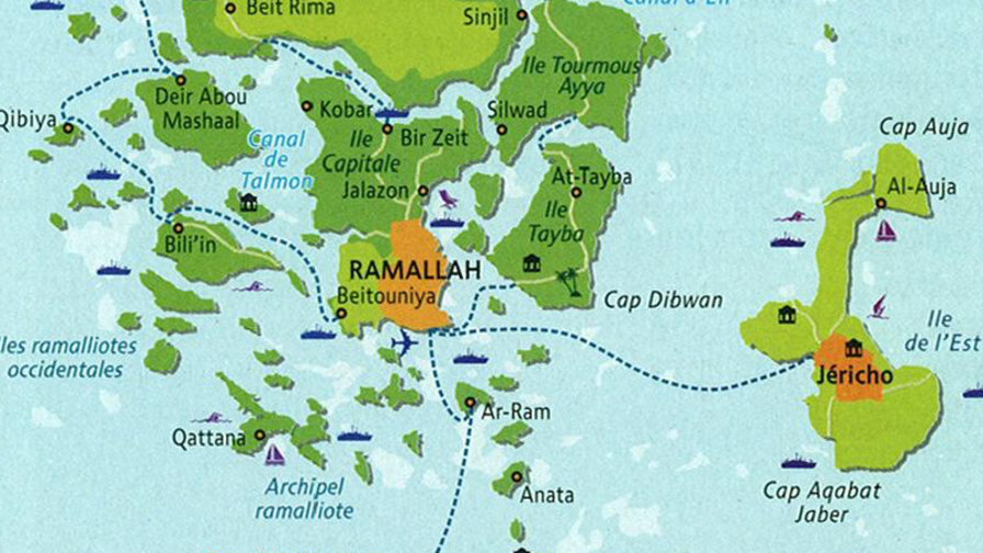
For such maps collectively created an affective tie to “place” over time, compelling map readers to develop affective ties in particularly compelling ways that led the territory currently occupied by Israel and the Palestinian authority circumscribed. The recent discussions of the impact that generated in the Obama White House at a map showing the circumscription of Palestinian presence in the state of Israel–or in their own homeland in the West Bank–suggests the tenacity of refusing to relinquish any sense of territorial continuity that would be needed to gain a sense of sovereign independence or territorial identity in wha was coyly if rightly described as a “Palestinian archipelago” by French cartographer Julien Bousac published the year Obama took office as President–with cartographic brio to reveal the inaccessibility to Palestians of areas under full Israeli control and occupation, revising the alleged Palestinian territory as essentially fragmented into islands removed from each other with what seemed natural barriers–even if they include areas populated by Palestinians–and the difficulty of imagining the territories recognized as Palestinian as approaching a territory. Indeed, the fragmented nature of the land is a set of outposts confined by military presence under surveillance, rather than anything approaching an actually autonomous or independent state.
 ©Julien Bousac, 2009
Perhaps the verdant greens of Brousac’s polemic imaginary map of an archipelago of Palestinian rule invites intentional misreading as a bucolic island paradise or vacationland, to suggest just how great a distance exists between the map and Middle Eastern (and Palestinian) realities. But its self-conscious use of the colorful iconography of a tourist map was disarmingly out of synch, and not a case of the brio of Francophone cartooning. For even if the cartographer rejects interpreting his map figuratively as “a ‘drowning’ or ‘flooding’ the Israeli population, nor dividing territories along ethnic lines, even less a suggestion of how to resolve the conflict,” but objectively describes the fragmentation of Palestinian population surrounded by lands that are occupied by Israelis and Israeli military soldiers.
The map invites a reading of just how much Palestinian negotiators found themselves “at sea” in negotiating with the Israeli state given the current situation on the ground, or swimming in an Israeli fantasy of concessions. It reflects the stark contrast between the fantasies of taking the concessions at the Oslo Accords as a working solution and the “grim realities” of actuality, where each outpost lies at a remove from the de facto capital of the Palestinian Territories, Ramallah, with which none are contiguous, even as all are surveyed.
The tenacity of such an effective fragmenting any territorial presence of the Palestinian Territories would provoke a realization of the political obstructionism of the Jewish State when virtually the same map circulated in the US State Department over six years later, in 2015. For the map of the same data, from hen presented within the context of a briefing book to inform American special envoys on negotiations between Palestinians and Israeli authorities, whose impact as a rendering of the isolation of Palestinian population centers in the West Bank was considerably grimmer. In the Oval Office, it didn’t allow room for misreading as a systematic isolation of the Palestinian people–

Rather, the disarming symbolism of the dry region of land only underscored the sense of an intentional dismemberment of settled lands. The dismembering of continuity or territorial integrity seemed only irrevocable response to the very notion of a two-state agreement, and a grim assessment of the project of two states that Israelis intended to pursue. The version of the ironic map of Boussac, at any rate, when it reappeared in the form of a state document by 2016, at the end of the Obama presidency, struck members of the U.S. State Department–though they were hardly new as a reflection of the situation on the ground–as they depicted “What a One-State Reality Looks Like,” as if lifting the veils from observers’ eyes who hadn’t grasped the geopolitical strategy of fragmenting Palestinian outposts int heWest Bank.
The description of broad shock on Obama’s part at evidence of such systematic isolation of Palestinian population centers sparked concern that it not be shared with Israelis, as if it were a state secret, even if it reflected the extent of Israeli settlement in the West Bank. (Some high-level U.S. negotiators though it could “raise awareness” about the systematic attempt to thwart Palestinian unity when Jews lost a majority status in the West Bank, Jerusalem, and current State of Israel–but the map was treated as a state secret.)
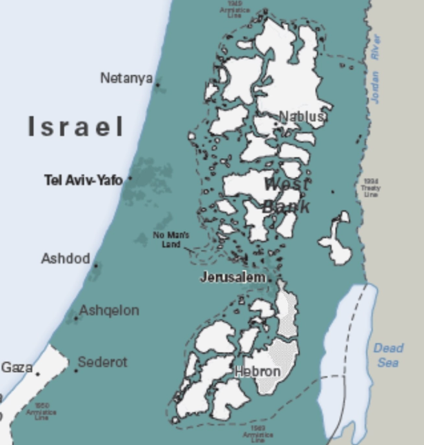
Perhaps the earlier appearance of Boussac’s map without a text–the State Dept. version informed its readers that the 6,335 million Jews then living in the longstanding sacred lands that stretch from the River Jordan to the Mediterranean Ocean were effectively outnumbered as of December 2015 by 6,561 million non-Jews who also lived in the same region–made the map less directly effective as an argument. But the figures–even if contested by Israeli officials–suggest that Jews are no longer a majority in the lands of Israel, Jerusalem, and the West Bank, in ways that suggest a new need to isolate the Palestinian presence there. The power of these observations rest in the presumption that the argument of jurisdiction is fundamentally one of democratic consensus, however.
This line of thought however runs the danger of dismissing the power of mapping territorial coherence in a religious imaginary, and indeed the scriptural power of the revealed nature of the map: if the map of Palestinian fragmentation, reprising the map, first published in Le monde diplomatique and widely shared during the Palestine Festival of Literature of 2012 as “brilliant,” it is perhaps better seen as tragic. For what was a revelation and wake-up call for the Obama administration and both the usually aware President Obama and his special envoy for Palestinian-Israeli negotiations, Joseph Lowenstein, who were loathe to share the map with Israeli allies, as if it were a secret, the maps’ revelatory power for the Americans must be balanced with the truly revelatory power maps gained as counterparts to scriptural reading. For the authoritative status of the map of middle eastern territories in the imagination as a record of the territory to which a people was implicitly and indissociably tied has long motivated in a way that is deeply internalized the mapping of Israel as a state.
Of course, the Boussac map was in the past rather superficially read as rendering a painful area of contested residence and war by such a “cheerful color scheme.” Rather than seeming to suggest a tourist map of an archipelago–with a “vacationy vibe,” as Big Think had it, echoing fantasies of a paradisal archipelago far from the “grim realities”–the starkness of imagining the actual locations where settlements were confined was made by the presence of battleships along the paradisal islands to denote zones “under surveillance.” Broussac presented the bucolic image as if in response to an interrogative as to whether the Palestinian people would ever be likely to regard this state of divided discontinuous regions of rule as constituting anything satisfactory. Much in the manner that the bucolic spaces of pastoral poetry were described as far removed from war, the “offer on the table” of dislocated outposts lacking continuity was in not in fact removed from war or a plan for the future, but evidence that the confines in which Palestinians were recognized would be a state of perpetual war rather than a starting point for peace.
Yet the map was also testimony to the deep resonance of the toponymy and cartographic mapping of the region within the Israeli and Jewish imagination–a prominence that plays no small part, pace Boussac, in the tenacity of territorial claims by the current Israeli state.
1. The particular power of toponymy in evoking a place of settlement–and resettlement–indeed reveals the power of maps in making territory.
Perhaps one must go back over four hundred years, to the start of a printed cartographic tradition. The excitement at the prospect of bounding and demarcating the region is clear in the prominence that Abraham Ortelius gave in his chorography of the Holy Land to the indication of its most famous metropoles and cities by his cartographical skill in a map of the reigns of Judea and Israel, originally from the collection of historical maps, or Parergon, which served as an erudite counterpart to the compendious atlas, or Theatrum Orbis Terrarum, that confirmed his deep humanistic and antiquarian credetials, as Walter Melion, Zur Shalev and others have examined. The map itself offers a sort of cartographical commentary on history that Ortelius, a great humanist as well as a cartographer, who saw his maps as encyclopedic compilations of worldly knowledge, printed simultaneously with the first printed atlas, or Theatrum printed in 1570 to great acclaim.

