Tag Archives: Israeli Defense Forces

Maps and Metaphors: Nests, Spiders’ Webs, Lairs, Warrens and Labyrinths

The Gaza War is not for territory, but is explicitly about erasing sovereignty. And much of the war, if fought above ground, is aiming at what lies underground, hidden from sight, and not on maps–even if we imagine that we might be able to map the damage, disaster, refugee flows and loss of life as well as destruction of structures across the Gaza Strip in ways that are truly impossible to process. This data overload, or information overload, responds to a proliferated media coverage of the disastrous war, but is also difficult to relate to the terror of the unmapped underground network of tunnels in Gaza, and the ways that the tunnel networks have been a reason for the terrible escalation of aerial attacks that have created such humanitarian catastrophe across Gaza and the Gaza Strip. As much as a war for territory, in a traditional sense, the Gaza War is almost one of purification–not purification in a religious familiar from the Middle East of the Middle Ages, but of the possibility of purifying the region to ensure Israeli national security.  And as a war of purification, it is almost fitting that the metaphors of vermin or unwanted animals dehumanize the enemy, as if a negative of actual residences or humans with rights. We are in a pre-Enlightenment discourse that denies all concepts of rights, or

The tunnel network that evolved from an infrastructure of smuggling to a means of tactical defense has become a target that is quite elusive: if the tunnel network beneath he Gaza Strip was underestimated quite dramatically at but about 400 kilometers after October 7–reflecting boasts of an Iranian general “Hamas has built more than four hundred kilometers of tunnels in the northern section of the Gaza Strip,” the estimated underground passages became a basis to underestimate the scale or intensity of its destruction. Indeed, the shock at the scale and technical quality of the underground network has been slowly grasped as far more difficult to target, as its size has since February greatly expanded to seven hundred or even eight hundred kilometers across the entire Gaza Strip. The tunnel network provides both a significant military and tactical challenge,–but one unable to be easily targeted or eliminated, even by existing mapping tools, flooding with seawater, the engagement of robots with facial recognition, or the location of hidden networks and their destruction. The tunnels under Rafah that are feared a network for smuggling arms from Egypt to replenish the arsenal of Hamas–underground tunnels dug under civilian neighborhoods that served as “terror nests” where Hamas commanders retreated–allowed the infrastructure of civilian neighborhoods to be destroyed, while the military infrastructure of Hamas remained intact.

Destroyed Buildings in Gaza Strip, November 5, 2023/Atia Mohamed/Flash 90

The hidden, unmapped expanse of underground tunnels, which Israeli intelligence for all its capacities seems to have misjudged, has become a target that has evaded mapping or location, turning the destruction of tunnel networks into a game of whack-a-mole, even with the prioritization of tunnel detection and warfare tools. Meanwhile, hostages held underground are unallocated, leaving the Israeli army far more “blind” in its engagement with Hamas. The intelligence of the network has been repeatedly minimized by metaphors as it is animalized as a warren, a lair, a spiderweb, or a labyrinth, as if to suggest its animal like nature, promised to be dissmantled as a structure of evil–an inhumane warren, more than a site of human resistance. The engineering of the network that has been able to be reduced in metaphors has expanded as an achievement of engineering–“beyond anything a modern military has ever faced,” per the chair of Urban Warfare Studies, at West Point’s Modern War Institute, making the conflict far more than academic–and a focus of global tactical attention of the shifting terrain of future combat.

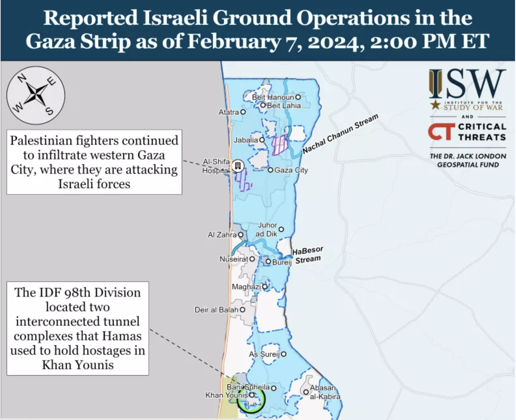
Meanwhile, it has only grown, as we have understood the existence of longer tunnels, fifty meters underground, as if underestimating the tools of engineering the warren, and the evolution of underground engineering that has allowed Hamas to dig in for the long war, making any lightning strikes impossible and only endlessly destructive. The destruction has been, as a game of Rope-a-Dope, infuriating Israeli Defense Forces, who seek to target an evanescent enemy; the Israeli Army tries to materialize its existence as a set of targets–even as the Israeli Army has issued repeated maps, in hopes to rationalize their expanding ground operations across an increasingly bombarded and devastated Gaza Strip, locating tunnel complexes where the hostages were once held. Is the war not really on two fronts, one, the human civilian casualties, who have been erased as “shields” manipulated by Hamas, and the true, hidden front, which is fought with a group dehumanized to the level of animals, not deserving of anything like a decent residence or shelter in the Gaza Strip?

The Gaza War was explained in no uncertain terms as the destruction of this hidden network in which the terrorists who planned the attacks of October 7 could be extirpated from the region of the Gaza Strip, as if independent from the humanitarian needs of inhabitants of the Gaza Strip, in a sort inexorable logic that leads to no apologies, but exists as an imperative that is the only narrative frame for bringing the war to its conclusion. “Dismantling Hamas’s underground strongholds in the north, center, and south is a significant step in dismantling Hamas, and it takes time,” we were clearly warned by Israeli spokesman Rear Admiral Daniel Hagari, in late December, 2023–aware of the intensity of bombing of hidden “nerve centers” of Hamas, but unaware of the visible brutality wreaked by the tremendous–and perhaps truly incommensurate–destruction above the ground. If Israel has destroyed many “cross-border” attack tunnels that extended some two hundred meters into Israeli territory both in 2008, 2012, and in 2018, the extent of tunnels that were celebrated in Al Jazeera back in 2014 for their ability to store weapons and shield Hamas leaders from air attacks as well as link the Gaza Strip to Egypt–and long designed a site of resistance to Israeli sovereignty.

IDF demolishes Gaza attack tunnel that penetrated 200 meters into Israel |  The Times of Israel

Destruction of Tunnel Network Dug into Israeli Territory/October, 2018

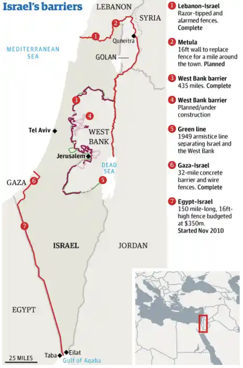
For as the network has grown as the governance of the Gaza Strip has shifted, expanding as a form of hidden sovereignty able to endure attacks and escape Israeli vigilance and guarding of borders of the enclave. Although “mapping tunnels in Gaza right now is not going to happen,” the tunnels have become the elusive map of power in the Gaza Strip, a “big reveal” that has become the focus of the war, revealing the terror of porous borders that were echoed by the discovery of five Hezbollah tunnels on the Lebanon-Israeli border in 2018, in a military operation, that seems to seek to frustrate the Israeli Defense Forces’ charge to “defend Israel’s borders, since the formation of the Israeli Border Police in 1948, immediately after the foundation of the state of Israel–a Border Police who have long worn the Green Beret, signifying their status and crucial military role, symbolizing the “Green Line” drawn on the early maps of the Armistice of the first Arab-Israeli Wars of 1949, the pre-1967 border that have been taken as contravened by illegal sites of construction. If the Border Police have long imagined “peaceful borders,” the nearly 20,000 structures built along the border of the Green Line were viewed as a “ticking bomb” in the West Bank after October 7 invasion.

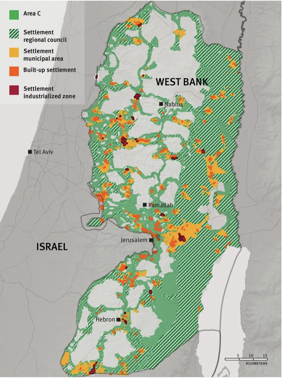
Years before the invasion, fears were raised by the scale of apparent bloom of illegal projects of Palestinian construction in Judea and Samaria, assembled by a combination of GIS mapping and aerial photography, as well as field work, that tracks the huge increase in “illegal” construction in 2022 in areas of Israeli jurisdiction by 80%–some 5535 new structures being built in 2022, an 80% increase over the construction in the same area in 2021, that are far from makeshift shacks.

Construction of “Illegal” Palestinian Housing in 2022/Regavim

The construction of what has been deemed strategically placed projects–and can be shown as such in maps of the region above–seem designed to hem in the settlements of Israelis around the so-called “Area C” of the Oslo Accords, if they might also be seen as overflowing the narrow areas allotted to Palestinians. But the huge construction project suggests an influx of cash, that might be seen as analogous to the creation of a costly network of tunnels by Hezbollah on the Lebanon border and in the Gaza Strip, as ways of challenging the stability of borders, and indeed the security of borders that has long been central to Israeli identity, and has become an accentuated topic of public concern in recent yeas–and least because off increased rocket attacks in Israeli territory.

In recent years, the ramping up of cross-border vulnerability of unforeseen proportions has placed the nation on tenterhooks that rendered most major Israeli cities vulnerable from the Gaza Strip with the rockets of Islamic Jihad capable to reach targets in Israel one hundred and fifty miles away, and escalated fears of the increasing proximity of the Gaza Strip to Israeli cities–long before the raid into Israeli territory concretized the fears of cross-border vulnerability in nightmarish ways.

Rocket Ranges of Hamas from Gaza Strip, 2022/Jewish Virtual Library

The same alarmist catalogue of the weapons that were posed at Israel’s cities by a range of rockets from the international market–Qassam, Katyusha, GRAD, and Iranian M-302, M-75, and Fajr-5–were suddenly aimed by surrogates at ranges to reach m-and Israeli populations in Tel Aviv or Jerusalem–were mapped, of course, by the IDF itself, who are tasked to guard Israel’s borders. as an armory poised at most all of Israel’s cities, far from the Gaza Strip, a decade ago. But we had the illusion, or geographic imaginary, for a decade, that those dwelling near the Gaza Strip were as protected as anyone else in the nation, and did not suffer any special degree of vulnerability.

The Deadly Arsenal of Hamas,Israel Defense Force, 2014

map returned to tabloids and newspapers in Israel after October 7, questioning the ability to allow such intensive proximity was haunting the Middle East. The increasing density of the projects of technically “illegal” housing was not a proxy or basis for cross-border attacks, or for firing rockets. But the worry of destabilizing borders by occupying such “seam zones” on borders grew, as they seemed to reveal a long-term strategy after the invasion of October 7, not even twenty-five kilometers from Gaza, and was worried in the days after October 7. The fears Israelis would be hemmed in would be potentially explosive if Israeli military presence in Area C was withdrawn, as in Gaza Strip from 2005; any Peace Talks, it was feared, that would sanction a Palestinian State would have to lead to recognition of their legality and potentially set the stage for a similarly catastrophic invasion of borders, as the rhetoric of an imperative of securitization grew.

Construction of “Illegal” Palestinian Housing in 2022/Regavim

They deep fears that the invasion of October into Israeli territory triggered and made palpable fears of a violation of Israeli boundaries in ways not previously imagined–and could only imagine after October 7. The fears that such an invasion could be facilitated by an existent tunnel network in the Gaza Strip the have defined the “goals” and prerogatives of the Israeli army to destroy, even if their danger is contested and not readily seen. And if we project such tunnels as a “satellite map,” we are preserving the false illusion that we even know their scale, or can “map” the network as part of the landscape–even if they are indeed part of the geopolitical landscape of the Middle East.

For the underground Islamic Jihad tunnels, lying far beneath the ground, and not able to be “seen” or mapped in any actual manner, the tunnel network remains largely figurative, spectral, and assembled in partially from old surveys from previous invasions of the Israeli Defense Forces, offering a poor proxy for targeting, but providing a terrible image of a hidden enemy, unseen and impossible to measure. As the earth that as extracted to construct the tunnels was dumped offshore into the Mediterranean, making it difficult to quantify the scale of earth excavated by tunnel-makers, or the scale of a network that has offered a basis for the Palestinian terrorists in the Strip to survive aerial attack, and indeed to keep the civilian “hostages” taken from Israeli territory under concealment–even as the “tunnel network” is also widely mapped in international news.

The web of Gaza tunnels complicating Israel's possible ground invasion

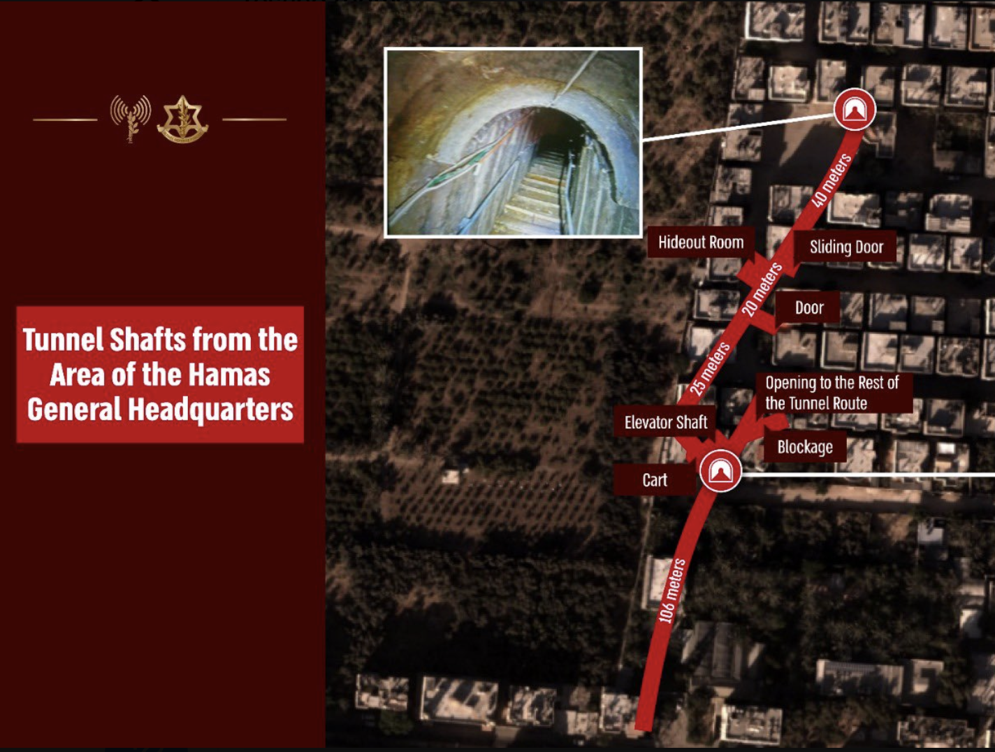
If we are shown “Hamas’ Secret Tunnel Network,” “Hamas’ Tunnel System,” or “Gaza’s Underground Labyrinth” in respectable news sources, and “Hamas’ Huge Underground Network” in somewhat salacious terms of more popular news sources, the secret spaces of these underground caverns have a truly Alice in Wonderland-like quality of an underground storehouses, or hidden hideouts, worthy of evil comic book characters, and apartments, tied to shafts, elevators, and other concealed openings, existing under the street plans of the city, as a “city beneath a city,” and even imagined as a future terrain for military combat, hand-to-hand wars, or the future zone of conflict.

1. The tunnel network is a remapping of the boundaries that are formally imposed around Gaza Strip. Although it is odd to see them as a form of counter-mapping against the claims to sovereignty in Israel’s boundaries, they are just that. For the tunnel network, if begun as an economic necessity, has been expanded and exploited to as a basis to deny the limits formally imposed by the 1950 Armistice Line, which has perhaps provided the basis for the energetic chants heard in public spaces across the Western world, to Free, Fee Palestine, that invest a coherence in the currently occupied territories as an enslaved region that has been left at the mercy of a “terrorist state.”

The Armistice Line concluded after 1948 Arab-Israeli Wars did not invest territoriality in a region–

–but recorded a status quo of sorts later preserved in the Peace Accords and 1955 Armistice Agreements at the height of the Cold War, a stalemate of sorts between global powers, to be sure, understood and enshrined in maps along the original reference points of a historic Palestine Grid–

1950 Armistice Line and 1955 situation of Gaza, Mapped within Palestine Grid

–whose construction was, to be sure, the legacy of a colonial or quasi-colonial movement, drafted by the English on the model of their own OS maps as a way of preserving the spatial organization of archeological ruins, but that have created a framework to what is misconstrued as a religious war.

The provisional line that was drafted at the foundation of the State of Israel, and provided the orignary boundaries of the state that was guarded by the IDF, as the persevered the territory that was newly mapped in terms of a UTM projection that extended, as the timeless liturgy of the Prayer for the Israeli Defense Forces suggests, and increasingly patrolled by IDF forces in order to contain threats to the security of Israelis living near the region, as well as the increasing number of settlers near the border. The mapping of the expanded boundaries of the Gaza Strip to deny access to the outside world or to Egyptian neighbors is nothing less than a classic micro-macro point of tension in global geopolitics–“over our land and the cities of our God, from the border of the Lebanon to the desert of Egypt, and from the Great Sea unto the approach of the Aravah, on the land, in the air, and on the ground” in existential terms–even if the 1994 construction of a barrier between Gaza Strip and Israel was stated to be provisional, unlike the current claim to have created an “Iron Wall” that offers no clear basis for future discussion–and indeed seeks to force future negotiations from a position of power.

United Nations Palestine Map Showing Armistice Agreements between Israel& Lebanon, Syria, Jordan & Egypt, 1949-50

The current construction of a heavily fortified “Iron Wall” has provided the current crisis in which the framing of Israel as an occupying power has morphed into charging it as a terrorist state–a reflection of the very terms that Israel’s government charges Hamas, and given the events of October 7, seems to offer ample justification for doing so. The effective boundaries, however, provide the clearest basis for containing terrorist incursions has however not served the state.

The “Green” Line has been an internationally recognized boundary of the Gaza Strip, defended by the Israeli Defenses Forces as such, never intended to be designed or rendered as a border of sovereignty, but has been construed as a political or territorial boundary in local and global geopolitics. If drawn independently from claims to rights of Palestinians, a question kicked down the road to an unspecified date for future resolution by the global consensus, increased fortification defense of a militarized barrier that maps the Green Line as an actual border–

–that hinges on the perimeter fence. If it is design to limit global traffic it is unavoidably now treated as a border that demands protection to protect “our land and the cities of Our God,” as the prayer written in 1967 has it, that have perhaps enshrined the dating of the time-stamped “1967 borders” or “pre-1967 borders” as the basis for a “demilitarized” future, a fact that might be datable in terms of history of globalization–hearkening back to a time when the United States was an engine for almost half the global GDP, before the United States abandoned the gold standard, and before the waning of American global economic dominance of the postwar–the era in which the Universal Transverse Mercator was adopted as a model of a smooth global surface.

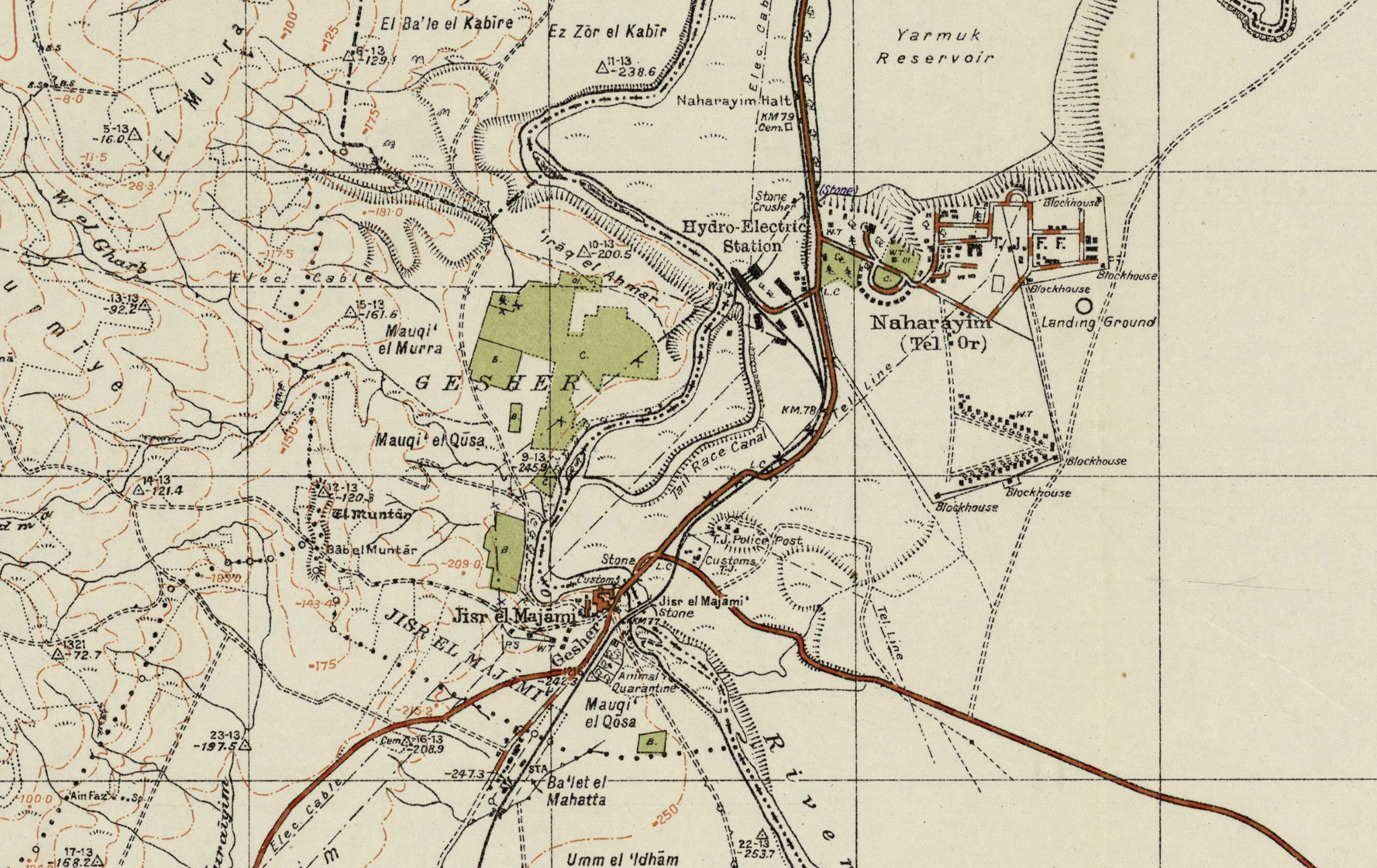
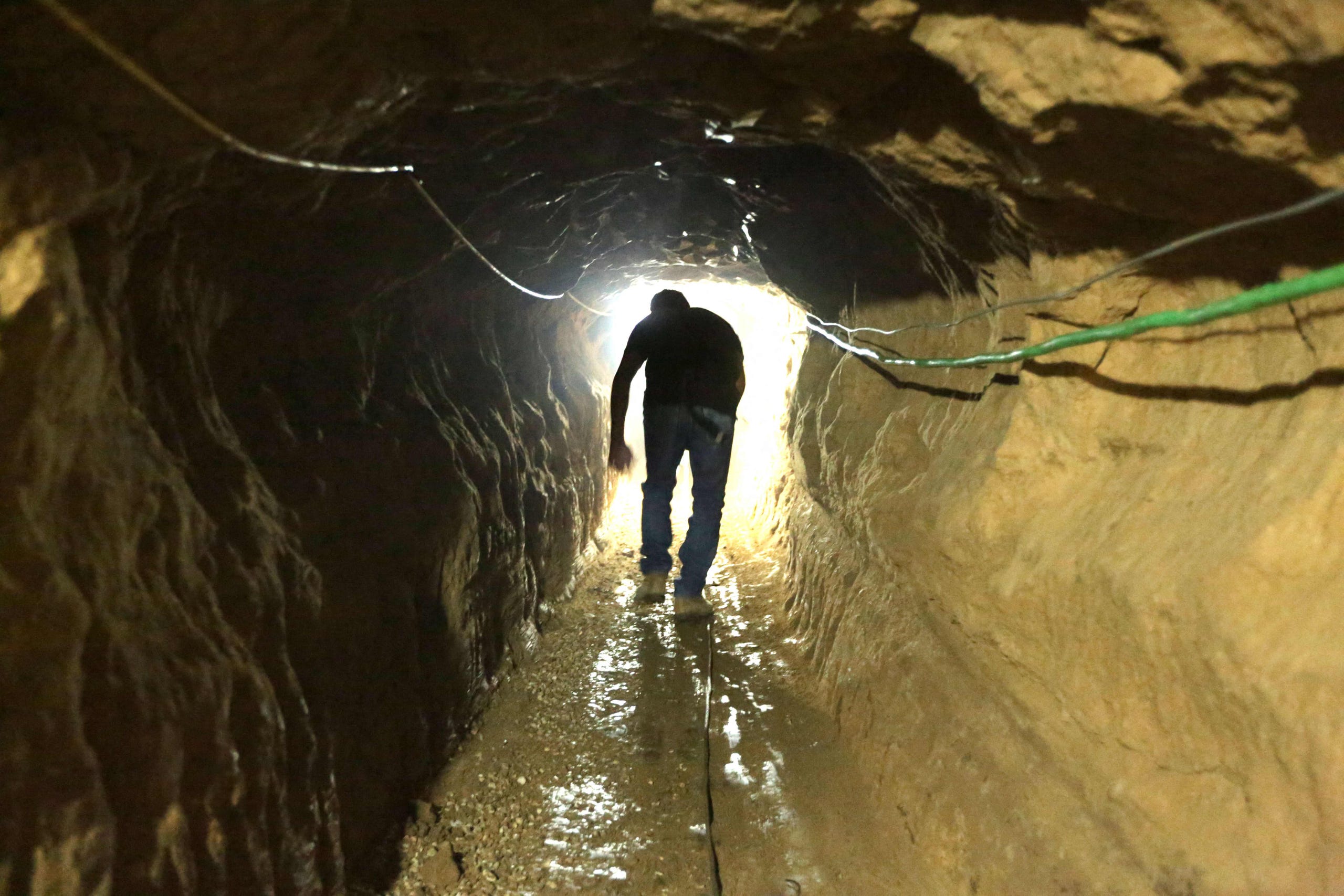
The network of tunnels that were dug under imagined border revealed its first porousness in 2005, with withdrawal of Israelis and Israeli troops from the Gaza enclave, and the expansion of a tunnel system that Israel had tried to contain. Increasingly seen as a threat to Israel’s sovereignty, the network has become a way of testing the borders that have emerged in an enclave once in 1955 tied to Israel by roads; the, contesting the so-called “Green Line” that divided Arab from Israeli sovereignty since 1950. If it is a sticking point in Palestinian peace accords, it is the stubborn site of the only survival of the old “Green Line,” the last line standing, that was set out in the 1949 Peace Accords, as a new “underground reality” emerged, not on most national maps, proved a way to erode–quite literally–a map seen as engraved in stone, contesting the original “demarcation line” seen and equated as an “original sin” of the “Palestinian Question.” While territories beyond the Green Line were not incorporated into Israeli sovereignty, the growth of robust tunnels along the contested “Philadelphi Route” running from the Gaza Strip to Egypt, was perhaps the original robust tunnel to smuggle weapons to evade Israeli surveillance, underneath the “security belt” Israel claims as a defensible border, as the tunnels appear to confirm an actual terrorist threat.

Hamas built tunnels to smuggle weapons under the Philadelphi Route from Egypt to the Gaza Strip. In recent years it has also dug attack tunnels from Gaza into Israel.

Robust Underground Tunnel of the Philadelphi Route from Egypt to the Gaza Strip

The “belt” is not a national border, or an international border, but has become defined as a “security border” analogous to the status of the Jordan Valley, by tactical terms first defined by the General who oversaw the victory in the 1967 War, critical to Israeli security–if not for its territorial identity. The bifurcation of the security border and national boundary at Gaza has grown as the boundary of the Gaza Strip become guarded as a border of Israeli territoriality, I argue in an earlier blog post, shifting understanding of Israel’s boundaries and their guarding. Guarding the Gaza “perimeter” is prioritized to securitize the borders of Israel for Jewish settlers who moved from the region beyond its walls, as new communities expanded beyond that perimeter, the tunnel systems have grown as an increasingly robust form of hidden governance, hidden from surveillance.

 If the network of tunnels first built to smuggle weapons in from Egypt in the 1990s before Israeli troops left, it expanded in depth and sophistication as Hamas gained control over the enclave and as it grew economically isolated, both as a network for importing goods and cross-border attack, extending five times below the depth of tunnels dug at the start of the new millennium, across a network claimed to extend over 500 km by 2021, according to propaganda videos of Yahya Sinwar, the length of the New York Subway, able to reach to Gaza City.  If the tunnels dug four to ten meters below ground seemed unstable beneath fifteen feet, the deeper tunnels are harder to sense by radar or to hurt by explosive force, as well as to detect from above ground–some over ten times as deep, if reports of 200 feet deep tunnel structures is true.  While the earlier smuggling tunnels of c. 2010 were closer to the surface and far more rudimentary in their framework and structural support–

Palestinian Entering Reconstructed Bombed Smuggling Tunnel from Egypt, near Raffa, 2012/Patrick Bay, AFP

–the robust defensive and offensive functions that evolved of tunnel networks demand more careful discrimination in our maps, and are too often suggested as primitive networks imagined as able to be removed from the Gaza Strip–rather than forms of its current governance. The expertise in tunnel engineering by lego-like concrete blocks, ventilation shafts and soil compacters helped expand the engineering of an underground network tied to Hamas, and increasingly hoped by Israel to be able to be removed form the region, the offensive and defensive network has gained increased resilience. And as Israel’s right-wing government linked itself to the defense of adjacent communities near the wall, and tunnels targeting of Israeli forces or settlements near the border grew in response to a vision of sovereignty that exclusively defined the state for Jewish citizens-settlements mostly made for those Israelis who left the Gaza Strip in 2005, now lived in by a new generation of settlers, familiar with demanding protections for living outside a region composed of refugees before the current refugee crisis created by Israel’s invasion.

Israeli Settlements in the Coastal Regions of the “Gaza Strip” before 2005

Unlike the territory of Gaza or the Gaza Strip that is shown in surface maps of houses, buildings, roads and communities, the underground network of tunnels that extend across the Gaza Strip were long both the de facto network of Hamas sovereignty and the targets of Israeli invasion and air raids. The mapping of the tunnel network has shifted from a target of attack to its re-mapping embodying identification of the tunnel network as the underground nefarious form of negative-sovereignty by which Hamas has defined its presence in the Gaza Strip.  The metaphorical mapping of the tunnel network has served to embody an image of the “negative governance” of Gaza, and metaphorically mapped to delegitimize the authority of Hamas as a responsible governing entity.

2. The networks of underground tunnels that grew up to support Gaza’s literally “underground” economy as its borders were closed by Israeli Defense Forces in 2005 became, in 2012 and 2014, the targets of invasion and destruction–as airplanes targeted five hundred tunnels, some of hundred kilometers, as one that running from the South to Gaza City, by bombardment and ground operations–destroying 140 smuggling tunnels that evaded the Gaza blockade, including 66 tunnels used to target Israeli forces. The engineering of tunnels expanded to deeper and broader underground corridors to ferry cars of militants and reinforced by iron, with ventilation for larger mobilization, the network emerged in global consciousness as a new terrain of combat, and a new battleground lying far beneath the ground. Even if North Gaza has, as Israel insists, ceased to be under the sovereignty of Hamas from January 2024, the tunnel network dug beneath the territory has provided the firmest illustration of the survival and resilience of Hamas governance in Gaza.

Israeli Soliders Patrolling Newly Discovered Tunnel at Erez Crossing, December 15 2023/Amir Cohen

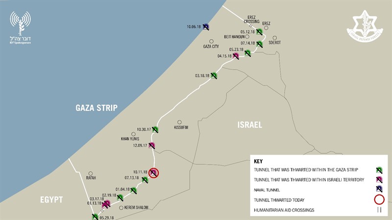
Tunnel networks in the Gaza Strip have been long targeted as threats to Israeli sovereignty. From their beginning as cross-border passages designed to import weapons from Egypt into the Gaza Strip, the commercial network that Hamas encouraged since taking charge of the enclave in 2007 for incursion. The networks of underground tunnels that grew up to support Gaza’s literally “underground” economy as its borders were closed by Israeli Defense Forces in 2005 became, in 2012 and 2014, the targets of invasion and destruction–as airplanes targeted five hundred tunnels, some of hundred kilometers, by bombardment and ground operations–to cut the enclave off from external contact, destroying the excavation of 140 smuggling tunnels that evaded the Gaza blockade, including 66 tunnels used to target Israeli forces.

Yet if the underground network that has however grown as a dense network of resistance to Israel’s denial of the sovereign presence Hamas has created deep in the underground tunnels of the Gaza Strip, a difference not shown in many maps of tunnel routes–which show tunnels collectively, akin to surface roads of OSM maps, without distinguishing either the origins, depth, or status as a hidden infrastructure, equipped with electricity, internet access, and communications, that long served as a regional tax franchise. The elision of the different tunnels, and their different quality, flattens the history of the network, and indeeds elide its central importance in Gaza’s governance, by portraying it solely as a target of attack.

Gaza Strip in Maps/BBC/NPR

While these maps are entirely the product of Israeli Defense Forces, they flatten the emergence of the tunnel network, and flatten the entire process of constructing, funding, and using the network of underground tunnels demonized as a target of military attack. Since the rise of cross-border tunnels that have been sanctioned as targeting Israeli forces, contesting the sovereignty of Israeli forces beyond the Green Line, the tunnel network was targeted of a vision of sovereignty that was tied to the invasion of Israel, and increasingly responded to by defined the state of Israel as exclusively for Jewish citizens.

But as the tunnel network has become a target of Israeli attack, it has assumed figural status by cartographic logic both to undermine the symbolic identity of Gaza Strip. It has served to demonize the sovereign claims of Palestinians in the region, and an image of the negative sovereignty by which Hamas has defined its place in the Gaza Strip. To flush that presence from the enclave, or to attempt to remake the enclave separately from the enclave that was attempted to be isolated by the Israeli army as a threat–by a 60 km fence, Egyptian built fence, and patrolled harbor–

–whose destruction has been suffered by the Palestinians increasingly trapped between a map and a hard place indeed, as the specter of tunnel networks has come in a grotesque macabre of Grand Guignol to take precedence over their lives, a spectacle of destruction of homes, intent to define attacks on the neighborhoods of Gaza City by targeting attacks on an elusive underground network of tunnels independent of their habitation or of the cost to civilian lives.

Continue reading

1 Comment

Filed under Gaza Strip, Israel, national security, satellite surveillance, tunnel networks

Eternal Borders and the Territory of the Gaza Strip

When I attended High Holiday services in an Orthodox synagogue in Oxford just before the October 7 attacks, it was probably for the first time in some years.  I was terrified of how to fit in. But the spatial imaginary that unfolded in the services days before the invasion of Israel’s “border barrier” on October 7, 2024 suggested how difficult the geography of the Middle East would be. Although it was familiar, I stopped at an old prayer in the Makhzor, or holiday liturgy, praying for the safety of the Israeli Defense Forces as they guard Israel’s boundaries over the coming New Year, 5785.  The creation of these boundaries was noted not in a moment, but have, changed over time. But the notion of fixed boundaries of Israel that Benjamin Netanyahu has long proposed in stated policies that have openly vowed rejecting any attempt to create Palestinian state between the River Jordan to the Mediterranean in a “Great Israel” had demanded Israeli control from the river to the sea–even if the area includes, according to Israeli demographer Arnon Soffer, of 7.53 million Palestinians and Arab Israelis and 7.45 million Jews of fifteen million residents. The shifting politics of the population, and indeed its distribution beyond the previously settled boundaries of the Mandate of Palestine, and indeed the 1967 armistice lines after which Gaza was first fully occupied, suggests the problems of settling and settlement that were so crucial to the current protection of the boundaries of Israel as a state–and the anxiety of their defense–in ways that made the prayers to the guarding of these boundaries unsettling if the concept was of course familiar.

The prayer was familiar, but stood out for me as I returned to religious service in a foreign country: the collective imprecation to preserve the IDF currently defending the borders of the Holy Land suddenly seemed an aggressive act. While the Jews living between the Jordan and Mediterranean are in a far more continuous space, in comparison to which the geographic space of Palestinians is of course a far more fragmented mosaic who are without comparable rights as citizens, the borders have been reified by boundary walls in an era when borders are not only far more heavily fortified than ever in the past. For the border barriers around Israel hold mental space before the cry to free the region “from the River [Jordan] to the [Mediterranean] Sea“–a slogan firmly rooted in aspirations for decolonization struggles of the 1960s, if to some ears maddeningly intentionally geographically vague, in ways that were seen as implying annihilating the Land of Israel Jewish state. But the deep insecurity that the cry seems intended to trigger, erasing the consolidation of land within Israel’s new physical barriers on its frontiers, evoke the precocity of the state in ways that the sudden. October 7 invasion from the Gaza Strip seem only to have been planned to promote.

But rather than confront the question of the continued denial of Palestinians citizenship or rights in a nation bordered by fixed boundary walls, the ongoing vigorous mapping and remapping of Israel as if it were a right of self-determination seems to be what the call to action seeks to place front and center. A counter-mapping if there ever was one, the erasure of Palestinian presence in the region that dates from the War of Independence has begun a cascading struggle to be contested and renarrativized in maps, making the mapping of Israel’s boundaries not only a historic removal–a fait accompli that one has to ask Palestinians to ‘get over’–but a living legacy that has been sought to be bolstered to a state of quasi-permanence any the bonding of ‘Israel’ by concert barriers and razor-wire topped fences manned by soldiers, more than a Zionist dream. The mapping of Gaza was not, perhaps, I was thinking as I read the letters, so far distant from the heady dreams that my father felt, in 1951, flying from Buffalo, NY to Amsterdam, before taking a train to Marseille and a boat to Haifa, amidst immigrants and refugees eager to arrive in a newly founded state to defend its boundaries, living for seven months at the renamed kibbutz of Gesher HaZiv, restoring the Hebrew names of the land, just ten minutes from the Mediterranean and just south of Lebanon.

s The kibbutz is fairly typical in that it was settled immediately after what was then patriotically called the War of independence, on the edge of the Lebanese border and the edge of the Evacuated Zone of southern Lebanon, recently the subject of Hezbollah attacks. If Gesher was a kibbutz by 1951, seventeen years before the kibbutz was founded beside an ancient bridge after the construction of a hydroelectric power plant, the old kahn Jisr al Majami was home to 121, including 112 Muslims and 4 Jews, by 1931 attracted over 300 Jewish settlers to cultivate oranges and bananas, and the kibbutz built atop the ruins of the old fourteenth-century kahn of which no traces would remain. When he travelled to Jerusalem, in late November, leaving the settlements founded in the 1920s, it seemed eye-opening as the landscape was so heavily inscribed with its own history of a recent war that he had been studying in class: a torturous trip through the hills of the Jerusalem corridor on the way to the northern Negev revealed extensive cemeteries of groups of soldiers who had ‘died defending the area–groups buried together according to the battles they fell in–rows of small white markers sectioned off’ the material record of the considerable ‘price paid for the hilly rocky corridor to our capital–for lifting the siege of Jerusalem.’ The journey that led him to view the ‘old Biblical city’ led him close to Gaza–near ‘where Samson and Delilah chased around,’ and in his visit to the coastal plain of the Mediterranean near the current Gaza Strip, a border of Canaan, as the Gaza Strip near Askelon–aware of the new policy of renaming, as Meron Benevisti, former deputy mayor of Jerusalem and historian helpfully put it, much ‘like all immigrant societies, we attempted to erase all alien names,’ and the ‘Hebrew map of Israel constitutes one stratum in my consciousness, underlaid by the stratum of the previous Arab map’ that it conceals. As an American, was the similarity to the renaming of upstate New York’s older native names not a possible parallel? The warrior Samson, delivering Israel from the philistines, provided a model as much as David fighting Goliath, provided a model, even if that weakness for the philistine women was potentially able to make the walls come tumbling down.

–became in the 1950s an industrial area indcluding a mammoth cement factory, electrical plant ‘to be run by Israelis’ and nursery of a million seedlings ‘for reforestation of the surrounding areas,’ more than a muscular site of combat that needed to be defended. Despite the expansion of severe restrictions on Palestinian ownership of land after the occupation of Gaza Strip in 1967, in hopes to prevent Palestinians from expanding abilities of permanent construction or economic development, the industrial zones that were  planned for the Neshler Plant to provide housing for the expected waves of immigrants that were hoped to arrive in Israel from the early 1950s–realizing the 1902 demand Benjamin Ze’ev Herzl had that ‘the construction of a state for the Jewish people must also take into account the founding of a Hebrew cement plant.’ The foundation of the plant in Ramla, as David ben Gurion proposed building a second in Beer Sheva, completed in July, 1953 was what my father witnessed, that produced bags of needed cement from August, 1953.

The trip that was sponsored by the Jewish National Fund, a major player in national development from projects of land reclamation and marshlands to afforestation to prepare land for settlement in large public works projects was based on a long-term Zionist effort to raise funds from Jews around the world to purchase lands for future settlement, growing form 25,000 acres in 1921 to double by 1927, founding some fifty communities, and by 1937 planting over 1.7 million trees in the Holy Land, that gave a new sense to the Jewish festival of Tu BiShvat, the New Year of the Trees, celebrated as a festival and a celebration of tree-plantings. Indeed, the stamps that my father sent home were uniformly a glorification of agricultural work, in keeping with the fiftieth anniversary of the Jewish National Fund, the main operation that had brought him to Israel to help ‘redeem’ the land–a project still celebrated in Hebrew, English and Arabic, reflecting the vision of a united state. That project of redemption has long faded into the past of an ideal of farmers nourishing the land.

By 1939, ten more cities were built by the JNF, including the Negev and Galilee, purchasing land for new communities that began in the war that housed European emigrant, focussing on the settling of the Negev and south–areas that were banned from settlement in the Mandate–as the JNF readied with new determination after World War II to launch a large-scale settlement campaign from 1946, based on the Zionist Executive’s fear that clear British planned to confine settlement to a small region outside a planned British protectorate in the south of the country, as they had greatly expanded land holdings beyond expectations of the first settlers, the map inviting but its borders were afraid to be clearly defined, as operation of settling the lands grew for collective farms.

If settled the land had no set bounds, imagined to be steadily reclaimed quite expansively. And by 1948, some 650,000 Jews had resettled 305 towns in the future state, the great majority (230) on JNF lands; by 1951, the fiftieth anniversary of the JNF, Israel’s population had doubled in but three years since its founding, setting the stage for a push of intensive afforestation began in the Galilee, where my father arrived, as the Martyr’s Forest planted for those killed in the Holocaust victims. If Jerusalem was not clearly on the map, the place of the settlements clearly was–

Map of Settlement circa 1925 in Jewish National Fund Tin Charity Box, Made in Ertez Israel, Keren Kayemet Yisrael (Design of 1930s and 1940s)

–suggesting an image of the conquest of space at a remove, but whose target near the Dead Sea was clearly identified as the holy biblical city of Jerusalem.

While the image of such an improbably conquest was removed from the land, the map that focussed on the Hula Valley, Sea of Galilee, and Jordan Valley offered a spatial imaginary that preceded the state. The Jewish National Fund’s ‘blue boxes’ symbolically mapped a covenant with the project of settlement diffused globally in the interwar period; the JNF indeed had by unification accumulated highly valued land across Palestine that were mapped with some precision in the diaspora, by 2015 holding some 13% of the lands open to settlement–if the plan to sever its covenant with Netanyahu’s state that year, as was planned as far back as 1961, was feared to plunge Israeli real estate markets into chaos.

Into this breach, with huge consequences for global geopolitics and indeed for the Gaza War, as the JNF helped to support the continued expansion of settler groups in East Jerusalem and the West Bank, the great-grandchildren of the owners of these charity boxes in the United States helped to donate millions to construct new homes for settlers that would displace the Palestinians, already long restricted from owning property from 1967 in the Gaza Strip. The current expansion of ‘settler colonialism’ in much of the margins of the Israeli state, creating a massive 26% spike in settler housing from 2015, foregrounding outright land grabs rather than purchased plots, often illegal, to reclaim Palestinian lands as ‘outposts’ of future territorial growth. By 2015, a full 15% of Israel’s Jewish population resided in settlements outside 1967 armistice lines of 1967. And the rapid defense of these settlement colonies in response to the attacks of October 7, 2023, revealed how intense the conflicts of religious settlement was on a global stage, as Netanyahu grew increasingly tied to American Republicans, and the delivery of increased weapons to Israel to defend its borders, and a growing right-wing support for Israel settlements in a new geopolitical map–and was based on the demolition of old houses with support from America, partly from fundamentalists and hard-line Zionists, that forged new and unprecedentedly convoluted if deeply symbolic transatlantic ties.

Human Rights Watch/map by Btselem, 2008, 2014

The regions of settlement were more a hope in 1925, of course, when early Zionist aspirations for claiming land, a claiming of land that has increasingly been at the cost of so many lives, both Israeli and Jewish, as well as Arab and Palestinian, that left not only 70,000 dead or trapped under rubble after two years, and almost 74,000 by 2026, according to the Gaza Ministry of Public Health, with some 1,200 Israelis and foreign nationals killed in the original attacks, and an incomprehensible level of bodily harm and loss only confined to the Gaza Strip–

–makes the defense of these boundaries both difficult to understand, and less dependent on any objective mapping, so much as the deeply psychic maps or symbolic mapping of settlement staked in the spatial imaginary in KKH collection boxes long ago, that spread a spatial imaginary that transcended monetary value, or actual consequences and practicalities of settlement, and a density of settlement in the Lower Galilee–

KKH Collection Box, undated

–offering clear and crisp toponymy in Hebrew script of Jerusalem, Tel Aviv, Haifa, and Ber Sheva as objectives far more durable than the tin boxes that they were manufactured to hold, but that even eerily seem to prefigure the very tools of data visualization increasingly central tools we use to visualize the ongoing if not seemingly unprecedented or unimagined intensity of this border war–

KKH Collection Box, c. 1925 (detail)

–casting the process of land redemption as a literal redemption of the land before Israel’s founding, of which Jerusalem, just off the West Bank of the Dead Sea, was clearly a target and eventual hope. The land was disused as not only mapped in detail, but by clear targets–indeed, striking Jerusalem as its capital, before the foundation of the state of Israel–

KKH Collection Box, c. 1940

After Jerusalem had indeed been secured the nation as the new capital of the state by 1951, when my father had arrived in the Galilee by the sponsorship of the Jewish National Fund, Gesher secured the hills near a large reservoir and hydroelectric station that promised the increased modernity of the process of settlement. The station and dam allowed the irrigation projects to flow to fertilize land reclaimed for farming, to feed an expected increase of population in a postwar fantasy of feeding and rebuilding the nation in the years immediately following World War II that had attracted a new generation of pilgrims and settlers to arrive from the United States. From imprecations to his parents that “I need no money–don’t you know that we can live without it?” in the midst of kibbutz life in mid-February, the collapse of the kibbutz project by mid-March led to requests for borrowing a small sum of money to extend his travels in Europe, promising to stay only in hostels and cheap restaurants, that ended up in his taking a boat back from Israel by the Spring.

Gesher in the 1942 Survey of Palestine

For my father, arriving in Haifa in the fall of 1951, the War of Liberation seemed narrated as a distant past: the kibbutz founded by Armenian Jews, was a site for marvelous starry nights founded by a union and surrounded by mountains, a developed site of ‘bright, beautiful surroundings,’ and blue skies, near an ‘ancient Arab village’ that was by now abandoned, ‘dating back to post-Biblical times,’ and a crusaders’ fortress in the nearby countryside. Attending lectures on Zionist history for the first weeks he lived at the kibbutz, as well as on collective farming and Israeli history, he spent evenings watching films, seeing plays, or learning Israeli dancing. Hearing of a nearby orange grove, he was thrilled at a sense of safety; yet the dangerous proximity of a kibbutz near the border with Lebanon inhabited by Arabs was vertiginous. “From here Arab territory is easily seen from the second story of the [kibbutz] library,” providing an undercurrent of awareness of the past inhabitants of the land that may not have registered in hitch-hiking across a ‘beautiful country’ or traveling by tremp, or hitch-hiking, as the attention of kibbutzniks was focussed on the impending potential arrival of the two million Soviet jews then hoping to immigrate to Israel. He admired how formerly Arab towns ‘now settled by immigrants,’ and saw the ruins of the Independence War in the landscape as a cost that was needed for this way of life, to add a layer of security to settlement of these hills, newly terraced fo future agricultural projects essential to projected settlement, both to create a historically important ‘buffer’ between the states of Jordan that had claimed these lands, and secure the edges of the new Israeli state, as well as a site for feeding its population.

While the collective farms that were central to the foundation of Israel in the immediate postwar period were going through something of a crisis by 1951, facing problems in attracting new immigrants, the belief that more immigrants were about to arrive became a basis for believing in the growth of the state, even only four were established in 1950, and the possibility of more emerging was constrained by water, and the political divides that emerged between labor parties divided the logic of settlements, at the same time as kibbutzim were not attracting the waves of optimistic pilgrims that they had in the past. The situation was indeed rather grim on the ground, if the rhetoric of boosterism was stronger than ever, and the possibility of a major National Water Carrier was increasingly needed for future agrarian development in the nation, and increasingly dependent on a policy of the confiscation of lands from 1951 from Arabs, rather than the use of land purchases. Passing towns that had ‘passed from Arab to Jewish hands several times’ in the War of Independence, he presented his parents a picture of deep historical past that within three years since the war had receded to a distant time, transformed by the cultivation of fruit trees and olive trees. By Chanukah, my dad relished signing his name in Hebrew, having encouraged that his parents were taking courses in the language he’d mastered in summer camps in upstate New York, but was now using on the ground: and he offered them a map of the place of potential resettlement, where a few neighbors from Buffalo had moved. The National water Carrier that had expanded by 2015 was already drilled through some hills, from the large hydroelectric station off of after the first damming of the Jordan River in 1932-48 promised power for Mandatory Palestine, just south of the Galilee at the Huleh Lake and Swamps, central to the “All Israel Plan” of securing water from the Jordan for the entire country from the coastal plain to the Negev, in an artificial aquifer that has allowed the state to grow, and expanded by 2015 to a central artery of national infrastructure.

The rise of cooperative villages, which my father later visited, were hoped to be a way to make the kibbutzim more profitable, and permit private consumption that was not encouraged at the first projects; newspapers reported land reclamation projects best by ‘strife’ as dissension between the dominant two political parties created divides in kibbutzim based on alternative views of the future of the cooperative settlement–in ways that were only lessened by the construction of a National Water Carrier as now exists, offering a sense of limited coherence to the divergent political interests and hopes that exist entire country, but increasingly marginalize the West Bank and Gaza from the prosperity a Carrier promised the state. The National Water Carrier bolsters agrarian projects and provides water to the kibbutzim that have longed run around Gaza, as if echoing the boundaries of settlement, and providing little more than water waste recycling centers in Gaza and Ashkelon, and some very limited drinking water essential for humanitarian needs.

The geography was not about clear borders, but of an expanded new world of labor and work. When he asked the kibbutz members what had happened to the Arabs who had previously lived there he was, he later realized, met with stonewalling: they ‘went somewhere else’ or ‘left’ as if on their own desires. When he took an excursion from the orchards and vegetable gardens of the kibbutz with a few friends to another nearby kibbutz, Nir Ayliahu, still closer to the border, he seemed to pass destroyed towns in abundance, in which kibbutzniks lived among in sturdy settlements to reclaim the land by resettling them by irrigation of the land. The border was written ‘boarder’–not a spelling error so much as homonym implying the Arab town was impermanent, as the ruins of a depopulated Arab village led only to marvel at finding a landscape of “hundreds of such places all through the country as a result of the war” of 1947-49, the ruins of a distant past that mirrored the biblical landscape he learned about in finer grain, as if to map a new territory that, if from a scriptural period, was suddenly being realized and replacing depopulated villages that were being swept off the map of the State of Israel, defined by a National Water Carrier that segregated access to water of Palestinians form the Gulf of Aqaba to the Galilee.

There was even a vertiginous existential fear at a landscape where such continued evidence of scars of wars were all too real than they had ever been for Habonim summer camps, and from the kibbutz he heard–in terms of an angriness I recognized, but was embarrassed to read, ‘the noises from a dirty little village across the way came from a dirty little village across the way came from people who yesterday lent a hand in trying to destroy the very place where I sit today and kill off half of the people around me,’ a rant that was trying to comprehend the fragility relation to the present that almost might not have been.

The emergence of a distant past geography of the past in a wartorn landscape left little possibility of cohabitation with Arabs as neighbors or fellow citizens. He surveyed an Arab village populated by ten thousand on the other side of the border as an existential enemy, determined to deprive the reality of a kibbutz he lived and farmed vegetables, with citrus trees grapefruit and oranges in a biblical imaginary of a land of plenty, covered the ruins of a destroyed Arab village erased from memory. A few Arab villages as Tira, of several thousand inhabitants, still lay in Israel’s boundaries, allowed to survive. But the geography of Kibbutzim replaced that of Arab villages, and the seat of government that had been partially transferred, leaving some buildings the ministry of defense in Tel Aviv, to Jerusalem, deferring the question of how the governing of the land included Arab settlements, or suggesting, if unconsciously, that such ‘boarders’ lived within the ‘border’ of a growing state. Tara was just to the north of the kibbutz Ramat Hakovesh, or Pioneer Ridge, of seven hundred sturdy immigrants where he pondered they ‘borne quite a battle during the war of liberation.’ The kibbutz promised rapid transformation of the ‘barest’ of barren land, irrigating the slopes of hills to prevent the environmental degradation of the Galilee in the Palestine Mandate. The collective zionist goals espoused by Hashomer Hatzair had hailed from Northeast Poland, but thirteen years before a Nazi invasion decimated the towns seemingly providentially founded by a dedicated and ardent immigrants, who had camped on land they purchasing from an Arab family not long before the disastrous 1939 invasion depopulated the enclaves they had lived.

Indeed, in the years of the celebration of “Settlement Day’ by the cultural wing of the Israeli Defense Forces that included visits to kibbutzim located near army units, including the screening of films, lectures, presentations, and exhibits on Succoth 1948, by promoting ‘frontier sites’ as ‘the defensive walls of the state,’ the inaugurations of a ‘Settler’s Army’ was charged with the task of ‘the preparation of the land for massive immigration’ that was expected, President Chaim Weitzman proclaimed the need for continuing the war with the ploughshare and the book by agricultural settlement to determine the future of the Israeli state: by Israeli values: and by including new immigrants to the Land of Israel, the proclamation of marching to a ‘light of settlement and defense’ in April 1949 led to the creation of fifty two new settlements, of which thirteen were in the Upper Galilee my father lived for seven months, five in Lower Galilee, ten in the Jerusalem Hills, and twelve in the Negev. Three hundred and fifteen settlements were created in strategic ways across the nation from that The kibbutzim embodied the sense that manual labor would be a means of agricultural ‘conquer the nucleus of the growth of the Jewish population of Palestine from 25,000 in 1882 to 400,000 by 1940 to 600,000 by 1948, the foundation of the state, in ways that formed the basis for the United Nations 1947 Partition Plan, effectively securing the boundaries for the modern state. Settlements, in other words, both preceded and provided the precedent for the logic of the territorial state of Israel in the Sketch Map for the borders of an Arab and Israeli states in the 1947 partition plan, and indeed helped set the borders of the Israeli state.

With the eviction and relocation of existing tenant farmers in some twenty to twenty-five villages from 1901-1925, only some of whom were compensated, the departure of residents had opened the region to prospective residents of a “Jewish State” that might exist side-by-side an “Arab State.”

JewisEconomic Union Sketchmap based on Jewish Land Settlements of 1947 Proposed by UN  1947 Partition Plan Black affixed squares of Jewish land purchases prior to 1948 against division of Arab and Israeli land

My father’s experiences at Gesher afforded an on-the-ground look at state formatino from the bottom up, based on the attraction of Americans and American money to energize the expansion of settled lands up to the outskirts of Jerusalem, and along the edges of the Gaza Strip and into the Negev. The newly terraced land my father helped settle in the kibbutz in Gesher offered confirmation of a far more efficient manner than earlier inhabitants had managed as if to illustrate the manifest destiny confirmed by the efficient application of years of labor to remake the land’s wealth in modern ways, impressed by encountering industrial engineers who had finished graduate work at the University of Chicago who were building the new country that would soon feature large airfields, and a ‘mammoth cement factory’ outside Jerusalem, in the rocky corridor of graves that marked ‘the price paid for the Siege of Jerusalem’ to capture ‘our capital.’ By Hanukah, studying Hebrew intensively for several months, he relished his father’s decision to begin studying Hebrew back home by taking to sign off letters in Hebrew script, accepting the new identity, dispensing tips on the festival in the reclaimed biblical language as a personal identity, as his increasingly personal relation to the land where the kibbutzim expanded and grew, disguising a colonial relation to the land, in many ways, as an unleashing of its wealth. The impression of the deep poverty of all Israelis for my dad led him to imagine a new relation to money, even if, as the kibbutzim ran short of funds, the need for more money seem to have sent him back to New York by late March, 1952.

The long-famous liberal Zionist pedigree of the founding and cultivation of this new relation to the land put into question by the October 7 invasion had set their primary mission to ‘conquer the land,’ without discussion of who resided there–and many of the kibbutzim around the borders of the Gaza Strip itself by Hashomer Hatzair members were placed on older Palestinian ‘Arab’ villages in 1949, perhaps even visited by my father, crating a sense that any place vacated by settlers would be filled by Arabs, and new American migrants might fill the land in proper ways for a new state, ‘conquer[ing] hill after hill without consideration for the law,’ as the current leader of the Kibbutz movement Nir Meir  expalined recently, promoting the settlement of new communities to seed the land in Galilee, which is now half populated by Jews, rather than eighty-five to ninety percent inhabited by Arabs. Peace with Gaza would be, for kibbutznik near the Gaza border, a condition of trauma and victimhood.

The land of Israel was in large part forged not by governance of the land, but by the kibbutzim that celebrated a series of civilian outposts to take ownership of the land, and indeed establish the Land of Israel. At stake was nothing less than effective modernization, and the transformation of a dry landscape to a bucolic new homeland–the model for an effective state. If ‘the job Arabs did of terracing was pretty lousy,’ so lousy they were ‘unable to be worked efficiently by modern methods,’ the modern tools of engineering prosperity and supplies of food preserved the ‘remains of an old Biblical city’ with new and old settlements in the Judaean hills readied for reforestation that offered ‘beautiful views of the coastal plain’ and more than one ‘old Arab village’ in areas where kibbutzim had been established for many from around the world–South Africa, Romania, Iraquis, and Germans–actualizing a hope of resettlement unimaginable in earlier years. The new alliances that filled the transformed landscape of the Middle East suggested nothing less than the opening of a new world to which my father felt he was witness, invited by the Jewish state to observe the new wheels of global democracy in action in 1951, in between his occasional visits to the Americans from upstate New York who had returned to settle the Holy Land soon after the end of the War of Independence.

That the kibbutz in the western Galilee was just over three miles from the border with Lebanon would become the de facto border of the state in 2024, and the final stop before an evacuated zone, policed by Israeli Defense Forces,–but a hundred meters from the zone from which the Israeli army had evacuated all civilians after the Gaza War began. The kibbutz of 60,000 became an outpost of sorts in a game of territorial borders, its pastoral appearance concealing the increasingly vigilant prevention of cross-border attacks and skirmishes, or attacks by explosive-bearing aerial drones that is targeted by the 130,00-150,000 rockets and missiles targeting Israeli cities and kibbutzim. By August 2024, Gesher HaZiv lay directly on the Confrontation Line in the Upper Galilee, subject to red alerts as contested land.

GISrael, Red Alert/@ILRedAlert, August 11, 2024

The kibbutz had been inherited as an outpost of the British Army in World War II, but was a site for war, before it became a site of Hebrew study of three hours a day, and privatized as a settlement in 1990. More recently, it has again become part of a war zone since Hezbollah had lent military help to the attacks on Gaza then day following October 7, a new reality of being a border town, and a hard edge of the state of Israel, increasingly demanding secure housing and military vigilance, if it was once seen as a tourist destination of Mediterranean architecture, serene gardens removed from urban life, promising ocean access to Achziv Beach’s tidepools, outdoors swimming, and camping in a large, bucolic national park. But the settlement of the United Kibbutz movement–‘Gesher’ means “bridge” in Hebrew, was an outpost founded in 1939 near the Naharaim bridge, reclaimed during Israel’s War of Independence as it was attacked by the Iraqi army and the Jordan Legion, is to the southeast of the Kibbutz, the original location a commemorative museum of the military battle. The erasure of contestation by agrarian work of fertilizing the long arid Galilee by water from the Naharayin Lake and the irrigation projects of the nearby Camel Hill provided a possibility of feeding a large populace of settlers, reclaiming the land by redeeming it for settlement, unlike the Bedouin itinerants who had lived there before.

Gesher HaZiv War

The original plan for the combined forces of Iraqis and the Jordan Legion to capture Afula changed as King Abdullah of Jordan told Iraqis the Legion would stay put in the West Bank in mid-May 1948, leading to the Iraqis to attack Gesher alone, eventually to be repulsed by Israeli troops from air and land, as troops from the Golan Heights forced the Iraqi troops to beat a hasty retreat to Samaria, and Israelis to secure the territory and a peaceful kibbutz moved to an English fort close to the sea, reclaiming a biblical historical landscape removed form the persecution of European nation states.

Travel Hotel Gesher Haziv, Gesher HaZiw (updated prices 2026)

The Mediterranean was blue, and a site for fishing, swimming, and wonder. But there as little sense of war in its blue expanse as there might be of the Trojan War off of Greek islands like Lesbos or Chios, transformed by tourist traffic and beckoning as a calm blue. Yet when my father, retired, when to work for the summer and practice his Hebrew by talking to medical students in the Negev, working with psychiatrists from the West Bank in Bersheva, traveling with a Human Rights Group to Gaza to visit the Gaza Community Mental Health Center in March, 1994, between downtime with hikes in the Negev–‘flower’ hikes, wistfully–in towns filled with Russian, Ukrainian, and Romanian residents, as well as Bulgarians and North Africans, mirroring the global attraction to the kibbutzim of time past. The Labor ZIonist past of the kibbutznik past was gone, but perhaps able to be recuperated in old age, My father had been struck that Israel was able to be seen apart from an American perspective in the 1950s, proclaiming local understanding the Middle East as the Eastern Mediterranean, as if a maritime region without boundaries or nations.

Visiting Jericho, Bethlehem, and attending a ‘Trauma Conference’ in Jerusalem as he worked in Beersheva, the contested boundaries of the Middle East seemed something he might navigate as disputed territories with a sense of security; he sent me a card from Beersheba of a pair of elite rapid deployment IDF fighting force of paratroopers descending from an airplane as a comic pair, one with parachute fully open, staring at the other the other calmly relaxing without one. The red-beret paratrooper descended without parachute and with a red beret must have spoofed an iconic image of vigilance and military bravery long featured in enlistment posters from the 1960s,–

— as if an icon of vigilance concealed his own anxiety by local humor, as well as a reminder of my love of cartoons– perhaps the cartoons themselves were a frivolous medium that maybe were a sign of my own oblivious disregard of existential threats?

Amazon.com: Israeli army IDF PARATROOPER brigade fighter (shavuzon) wings  BADGE Israel cobra snake pin : Clothing, Shoes & Jewelry

IDF Paratrooper Brigade Fighter Wings Badge of Cobra Snake

Maybe vigilance was not the point, but a new detachment from the political situation on the ground. When my father arrived in Israel in 1951, the glory days of the United Kibbutz Movement a massive way of collective settlement the contested Arab lands. If once seen as seamless with the Labor Zionist movement from eastern Europe and Germany, the recuperation of idealistic Zionism might include Arabs as well. But the hope to offer them ‘excess land’ by 1951 had all but vanished, with the loss of Socialist Zionism. The split of the United Kibbutz Movement the very year my father was working on a kibbutz between the socialist labor forces and led the agrarian settlement movement to fracture along the lines of a central schism of openly ideological nature. My father was stranded in the middle, in a sense, having tethered his dreams to the labor agrarian cause of collective work, that he would wrestle with the rest of his life, even as the defense of settlements became an increasingly prominent platform of the Netanyahu era.

If the Kibbutzniks were a form of early colonization, a ground forces of sorts that provided not only a claim to land, to resettle old Arab villages in a Nakba, but a demonization of their Arab-speaking neighbors as if invaders of a resettled sacred space, complete with monuments of actual biblical events that those making Aliyah could visit, but oblivious to the borders that were being created in ways that would be defended by armed outposts in the years after the so-called Palestine Partition Plan the United Nations adopted but four years before my father arrived in the new state of renegotiated and perhaps negotiable borders, before the Israeli army came to exist from militias that encouraged enlistment into “service to the nation” as a new ideal of nationhood, mobilizing the Israeli Defense Forces as a professional army to secure communications and continuity between Jewish territories to preserve a coherent nation.

Seventy five years later, the increasingly militarized borders of the nation-state made the prayers recited on the High Holidays particularly disturbing days as tensions grew in the days that preceded the October 7 invasion, an d the shock of an armed incursion of sovereign bounds of vicious civilian and military deaths. The fears of any assault of Israel’s territorial claims have been met by the increasingly intense fortification of its borders, a ramping up of its claims to “security” and “securitization” that has eroded the ethical values of the state, the defenses of these boundaries were both more militarized and less sustainable in the future, though which Habonim fell. The services that I attended in Oxford on the eve of the October 7 invasion included a prayer for the protection of Israel’s boundaries that placed dangers just beyond them. Having hoped to begin the New Year by hoping for the security with which they were guarded–as if they were granted by divine right but embodied by militarized defense–was unintentionally quite off-key, and made me grind my teeth during the High Holiday I had arrived to celebrate with some trepidation in a foreign country,–not seeking real friendship or continuity but hoping for familiarity as I set to orient myself to a university city I recently moved with my wife, trying to find some stability myself in what was in its own way a new land where I was more stranger than I’d expected, where I’d almost come to see myself as having parachuted but weeks before the October 7 invasion of Israel from the Gaza Strip. The prayer for the defenders of Israel’s secure boundaries seem to have sensed the immanent strike or need for protection, the threat having boiled over on the edges of the Gaza Strip before the invasion broke out so dramatically in international news to global shock. As belief in the regular degradation of Hamas forces in the Gaza Strip persisted, described now by the weird expression ‘mowing the lawn’ by indiscriminate bombing campaign, an attempt to disengage but preserve security, targeting and attacking the ‘captive population’ on the borders of Israel and refusing to negotiate. Bombing neighborhoods indiscriminately became rhetorically reduced to an operation of maintenance, whose consequences were never fully assessed.

While I was not concerned about Israeli borders, I was struck that the unexpected ritual invocation of the guarding of boundaries carried deep weight for the members of the congregation, reminding me that the prayer–an addition after the 1967 War– had long assumed deep significance. If the New Year’s holiday had some spiritual resonance and traditional power as a way of marking time, the sense of bonds among Jews grew with the coming invasion, making me negotiate my relation to the service I had just her. Indeed, the explosiveness of the invasion that left me and my fellow-expats reeling and hard to observe at a distance made me interrogate where that prayer had origins, and reflect how the literalization of a project of boundary-guarding had become so dangerous project of courting risks of raised the stakes, intentionally turning a blind eye. If the war was an invasion of Israel territory, the border zone between Gaza and Israel has, perhaps rightly, long been the subject of attention of Israel’s Prime Minister, who has repeatedly emphasized “stoppage points” and “closure” of the Gaza Strip and control of the border zone between Egypt and the Gaza Strip. The military securitization of these borders were hard to reconcile with the benedictions of the kindly rabbi. He led his congregation a final time in high valedictory form at the cusp of retirement, and stylishly negotiated the benediction to George V in our Mitkhor, to my ears, in an Anglican version asking for the safety of the royal family. In a sermon voicing dismay at the strain of lamentation strains of Judaism that he felt had infected or reconfigured Jewish identity at some loss of its original liberal optimism and pride, he wished us to engage the year ahead.

For a strain of lamentation, derived from the poetics of the laments of the Psalmists, but expanded to the elegiac account of suffering and commemoration that expand the liturgical elegies to accounts of forced conversion, expulsions, crusades, pogroms, and even assimilation short-changed pride of a “chosen” people, the rabbi felt, undermining a sense of pride. The ancient strain of lament in Jewish poetics and poetry certainly decisively expanded in twentieth century before inexpressibility of the Holocaust, and a need to express inexpressible pain in the face of fears of annihilation. But the logic of lament of would come to the surface with quite a vengeance after the unprecedented invasion of Israeli territory on October 7, only weeks after the rabbi’s sermon, as the unspeakable trauma of the crossing of the fortified border of Israeli territory opened existential fears that set in play a logic of retribution. If lament pressed the borders of linguistic expression and actual comprehension, the escalated response metthe anguish of lamentation demands, but no response can ever fully satisfy. The call to pride, and even content with being Jews, was somewhat tempered by the calls to save the warriors defending those highly militarized geographic boundaries, as much as boundaries of expression.

The boundaries of Israel as a “state” had become not only embattled, but less defended lines than firm fences, rigid, and asserting a statehood removed from negotiation, and perhaps from Zionism, as they were understood as bulwark against Palestinian expansion that so tragically ended with the battery of hundreds of ground-to-air rockets forms the long-barricaded Gaza Strip, serving as cover for a bloody invasion of Israel planned for a decade, approved by Hamas leaders in 2021–even known by some of Israel’s intelligence forces as code-named “Jericho Wall,” an attack of unmanned drones to disable the surveillance towers along Gaza border wall, to attack military bases, but dismissed–if it was also feared to constitute “the gravest threat that IDF forces are facing in defending [Israel].”

2 Comments

Filed under boundary walls, Gaza Strip, Greater Israel, Israel, Middle East, October 7 attacks

Bats over Urban Skylines

Thomas Nagel queried the possibility humans had to “know what it is like for a bat to be a bat” in a 1974 paper that posed pressing epistemological challenges beyond the philosophical community. Nagel was asking us to consider what was the context in which bats move, and to consider the foreign nature of propositions about the distribution of a network of flying bats to humans’ embodied experience: the winged mammals that may have inhabited the eaves of the philosopher’s old summer house in Connecticut or Vermont–I am guessing–where he rises from his desk to spend the early evening watching bats reel out at dusk as they fly in wide arcs, searching en masse to seek out meals of bugs and gnats at dusk. I imagine this only because there is a sense of wonder and of coming against a mental edge that is impossible to get one’s mind around in those wonderful sentences, “I want to know what it is like for a bat to be a bat. Yet if I try to imagine this, I am restricted to the resources of my own mind, and those resources are inadequate to the task. I cannot perform it either by imagining additions to my present experience, or by imagining segments gradually subtracted from it,” They are worthy of Thoreau, as entirely earnest and committed, and at least as beautifully Latinate.

Asking what it is like for a bat to be a bat suggests a new model for collective action, not bumping into one another by using spatial registers in ways we don’t really know how to map–or to even think we can.

Maybe he was in Florida, near Gainsville, or Tampa Bay, where homes for bat colonies have been constructed that offer them temporary housing–

–watching a bat colony search for bugs and flies at a time when the flying mammals are losing safe natural habitat, displaced by construction and environmental saturation of electric lighting. The instant of inter-species realization that launched an epistemic earthquake might have been launched when, returning home, evening drink in hand, Nagel retired to his desk after dinner to write an article arguing we lack not language but adequate mental tools to think like a bat, let alone to “know what it is like for a bat to be a bat,” or imagine a bat-like proposition about space. If the “bat’s point of view” is foreign to our own individually embodied experience so removed from a distributed network to imagine flying through the air or moving the the darkening evening sky–let alone accurately navigating–like a bat, in clouds of a distributed intelligence foreign to the individual human mind, let alone the bat-versions we imagine of pain, fear, hunger, lust, loss or desire. The problem allowed him to ponder the “subjective character of experience,” but may have driven a wedge between human-space and bat-space we are trying to emerge.

Are bats able to synthesize, share, and collectively process a sense of the images of the outlines of trees, skyscrapers, and blocked routes, by abilities to synthesize individual datapoints in something like a collective map map? If it was a philosophical topos of sorts to pose thinking like a man or thinking like a bat, that was inherited from philosophers before Nagel’s essay. Isaiah Berlin, who sought to describe the dignity of human feelings, had little regard for bats, from whom he felt some repulsion– ‘I don’t like flying insects, moths and things, and I hate bats – if I were in a room with bats, I should go completely crazy,” he wrote, describing the bat as a provocation sufficient even to unhinge the most rational of minds. He had traced it back to a fear of moths from his childhood, that his mother indeed took him to a doctor in Baden-Baden to diagnose as a phobia of insects, but found himself unable to relax in the presence of a flying insect or bat. (“‘I shan’t be able to relax until it’s gone,’ but adds, ‘but don’t kill it!’“).

Nagel may have been far less phobic about bats than the towering authority of Wolfson College, but was more interested in the sensory apparatus that contributed to the distinct subjective realty of being a bat, a reality that Berlin seems to have acknowledged readily in the strong reluctance he showed for killing a bat–rather than the unique means of echolocation by which they navigate space from the reflections of the modulated shrieks they send out to detect objects within range, as a form of sonar, as a distinct way that their brains use to navigate space. The inaccessibility of the “inner life of the bat” might be restated as a problem of mapping, however, at least in how we can accommodate–if not understand–how bats navigate space, and indeed understand bat sociability as a problem of mapping, rather than excluding bats’ skills of echolocation from anthropocentric maps. If they have a different sensory apparatus, how can our maps better accommodate bat sociality, as much as bat minds, to the way we map space?

The philosopher performed a powerful thought experiment about human consciousness about the subjectively rooted nature of human experiences, by inviting us to consider what he took as the vast intellectual remove of the experience of those nocturnal navigator. We might, Nagel imagined, well be able to adopt “the bat’s point of view,” rather than a human, if being like a bat did not escape the conceptual tools humans possess. While Nagel may have been looking into the night sky for his historical experiment, the mass knowledge of the “bat” as opposed to the individual actor of history was a stock figure of philosophers, hit upon by the belief philosophers focus on human knowledge and human experience–“what it is like to be a man and not a bat”–might deserve to be reframed. For as human space and bat space intersect and overlap in new ways, we may find the need to try to imagine how their habitats overlap like a Venn diagram. And we do well might to start to do so as a need to try to consider what it would be like to be certain about how bats to move through space in a distributed network of collective thought based on their experience of the world, to extract ourselves form such anthropocentric models of spatial thought.

While Nagel did not necessary mean the swarm thinking that enables bats’ behavior, it is striking that the logic of the swarm of bats’ nocturnal flight paths–that employ vision, but don’t rely on it–may be providing a basis for the new “training sets” that push new horizons for AI intelligence, beyond the “training sets” used to develop computer vision that has helped “train” how computer vision might “see” and recognize facial characteristics. As echolocation helps bats track insects, not crash into each other as they fly in large groups, and navigate caves, moving by sounds, as much as visual cues, the abilities it allows–for densely flying animals to somehow not jam each others’ sounds, but fly side-by-side in large groups without touching, evading one another without audio interference, and distinguishing the recognizable pitch of one another’s individual calls–they may offer a way of being within a distributed network, sustained at over sixty miles per hour–and within underground caves from which up to half a million bats nightly emerge. This would be a form of distributed intelligence and a form of “intelligence,” Nagel’s work reminds us, removed from human ken.

Bats’ powerful bioacoustic abilities to distinguish individual echolocators without interference in crowded caves may offer a powerful model for using sonar signals to create a similar capacities of sonic recognition among the range of sensor data that self-driving cars use by emitting distinctive levels of sonar so specific not only across different makes, but individual drivers, allowing swarms of commuters to calibrate their spatial relations to other commuters by an analogous sort of distributed intelligence: might autonomous vehicles, in other words, be made to think like bats? The thought is tempting, as it would push a new basis for drone “thought” and warm thinking and movement, if it remains a bit of a pipe dream quite different from the current base-maps for self-driving cars, based on mapping roadways, directionality, and the driving cues of highway signs, turn routes, and the sort of tacit signs of how we move cars within lanes, along painted reflective dashes, to prevent or reduce automobile collisions.

Civil Maps

But what are the maps of bats? Could the flight paths of bats ask us to reimagine maps? The level of auditory discrimination is at basis, perhaps, a question not only of “technologies of extremely accurate localization” but bioacoustics. Much as LIDAR might create a point-cloud for areas that are lacking in many topological maps of routes to estimate the areas of roads on which autonomous vehicles might travel, is there a chance that bats move mentally among multiple scales and registers of mapping, moreover, both to navigate among one another’s flight paths while traveling in the night skies at speeds that are often up to 60 mph, and to take paths that allow them to return to the security of caves or other diurnal dwellings?

The problem was how the sort of state-of-the-art maps for autonomous vehicles that were dependent on existing maps would make sense in the dramatically changing extra-urban and rural environments on large scales, and how such rapid development of built landscapes could limit the potential positives of autonomous vehicle technologies: often, these areas were the same in which many commuters lived, and where the benefits of driverless cars would be felt, so the benefits of unmooring cars from existing maps was more than a purely academic challenge.

 Detaled Trracking of Roads in Unmapped Rural Roads/Ort, Paull, & Rus (2018)

The bioacoustics tools bats use to negotiate in swarms and on individual rest on developed abilities of acoustic recognition that might be especially important to autonomous vehicles–for which the motion between large scale maps and the mapping of fast-moving vehicles beside them remain something of a missing piece, if not a potential cartographical blind spot for modeling distributed spatial intelligence by sonic blasts.

Bats may hone these auditory skills of discrimination of sonic frequencies by skills honed by preparing from departure deep underground in caverns, developing echolocation systems that allow them to capture insects while flying that are less than a centimeter in size, though the presence of a still human can confuse bats’ sonic maps for judging moving prey, while navigating swarms of over 1.5 million–15 million live in Natural Bridges underground caverns, and caves in Carlsbad NM once housed up to eight million.

Natural Bridges, TX/National Parks Service

The ability to map individually and in a swarm make their ultrasonic pulses a powerful tool of acoustic discrimination of routes, but the images bats preserve in their mental maps are not nearly so existential in nature. Indeed, the colony of a million and a half Mexican free-tailed bats that live in downtown Austin, under Congress Bridge, beleived to be the largest urban bat colony in the world, is so prized by the city’s human residents that the emergency of maturing bat pups in the Central Texas night sky is advertised as a cheap thrill during fall sundown of vertiginous biophilia, the dedicated “bat hotline”–(512) 327-9721–provides visitors eager to witness the swarm with confirmation when bats are seen emerging downtown

Bat Conservation International

–a biophilic spectacle that highly demonstrates the intricate networks of distributed knowledge as young pups learn to fly, that is a prominent part of the Central Texas city’s ecology. Perhaps a splinter group from the nearby Bracken Cave colony–one of the densest sites of mammals on earth, just a half hour northwest, is the largest known bat colony in the world.

Inspired by the broad arcs of nightly emergence of bats from New Mexico’s Carlsbad Caverns National park as Pearl Harbor was attacked, a dentist first promoted the idea of using bats for fire bombing of Tokyo’s wooden homes. The plans for outfitting thousands of bats with explosives affixed to their little chests–treating the bats as dive bombers to create spontaneous conflagrations in Japanese cities–developed as the letter sent to President Roosevelt led to plans for a nocturnal release of thousands of bats, bearing explosives on their chests, who would roost in the structures of Japanese buildings by treating Mexican free tail bats as a squadron of blind dive bombers who, transported across the Pacific to the eaves of wooden houses in Tokyo, might provoke an incendiary attack by distributing packets of napalm–the basis of incendiary bombs–by the far greater geographic area of bats on whom chests were affixed napalm adhesive vests. Sequestering a thousand free tails hibernating in isolated chambers for trans-Pacific travel never bore fruit; optimistic simulations revealed explosive packets regularly impaired flight and “uncertain behavior of bats” glossed the failure to cooperate in destructive fantasies of using winged mammals to distribute urban conflagrations by 1944, if disastrous experiments in California created some massive explosions. Despite the failure to orchestrate a swarm of bomb-bearing bats, plans to parachute a swarm were brushed aside by OSS director William J. “Wild Bill” Donovan punctured as the “Die Fledermaus Farce,” dismissing the fantasy of costuming bats for an air raid by an Strauss operetta promoted into the operatic repertory to ridicule the strategic value of an airborne zoo –putting the cruelty of immolating flying mammals aside. The basic truth was that the bats’ flight could not be planned.

Canister Designed by Louis Fieser for Dropping Hibernating Bats on Japan

The remove of such a bomb as a way of creating winged kamikazes removed nature of hopes for the strategic deployment of bats in a global strategy from what it is like for a bat to be a bat, or how bats think. But could it be possible to approach the mental outlook that enables bats to navigate nocturnal skies at high speeds in search of fast-moving food? Perhaps Nagel’s project influenced how, since 2011, Israeli researcher Yossi Novel attempt to cross this bridge of consciousness by a colony of bats–nearly 20,000 winged mammals–that he raised from birth to maturity, and tracked their progress as they navigate Tel Aviv’s skyline, using the city lights to navigate their paths home. By fitting the small bats with the “smallest GPS [then] in existence” of about ten grams, scientists charted paths to uncover secrets of the mammals’ neural abilities of nocturnal navigation around man-made waypoints in Tel Aviv’s and the most “visible” nocturnal monuments to detect their cognitive abilities.

While perhaps not as elegant as aerial V-formations of geese, pelicans, or storks, timing their wing beats to catch eddies of air that seem to save birds some 20%-30% in energy, minimizing downdraft to an aerodynamic advantage, and flapping in phase to maximize energy by an anti-phase synchronizing of wingbeats in V-formation: bats’ far smaller wingbeats evolved fewer aerodynamic problems, and responded to fewer challenges of long-distance migration, but offer evidence of assembling spatial maps over time over a surprisingly expansive distance range. Far from a costume party of human orchestration, in a staged ball based on costuming bats, the bats’ flight was nightly tracked.

Indeed, the almost nightly expeditions of bats–some 15 million from caves north of San Antonio TX, in summer months–that show up on radar as explosions of “bioscatter,” as they emerge from caves in search of food, is so striking at large-scale that the small-scale tools of navigation by which the bats move from sundown need to be mapped in relation not only to seasonal meteorology, artificial light, and human disturbances of the environment, although it might be better to begin from more basic–still insufficiently understood–questions of how bats, all too often mischaracterized as “blind,” regularly map space. The National Weather Service mapped nocturnal emergence of bats from caves in Central Texas on its radar that appear to be explosions of meteorological imbalance, but in fact only track the nightly emergence of millions of bats, an efflorescence of cave-dwelling mammals bursting into flight from underground sites–what weather forecasters dismiss them “bioscatter” which raises immediate questions about the bats’ mapping tools, and the distributed networks of navigation that allow bats to fly across the state in search of food, without ever crashing into one another’s paths of flight.

if all maps are ‘surface readings’ and of necessity exclude often crucial sensory “noise,” do those green explosions miss the miracle of bioacoustics that allow sophisticated level of auditory discrimination for bats to move with a sense of where they are going–or what to avoid and what to eat!–while registering or encoding a map to allow them to return to the caves? What are we missing in mapping those bats as mere “biostatic,” of no meteorological significance, we are now asking what sorts of sounds bats are making to one another as swarms disperse from what seem fixed points? Are the bats best mapped as swarms, or do they have individual flight paths, and, if so, what is their form of air traffic control?

Without explicitly trying to revisit Nagel’s thesis, the data gained about the bat’s spatial sense of navigation and its brain capacities provided a sense of navigation as they flew above Tel Aviv’s skyscrapers in relation to the tallest towers of the built manmade environment by a GPS of their own devise, that revealed how bats possessed uncanny navigational skills to fly in straight lines at considerable elevations of over a hundred meters, using as points of reference trees up to twenty-five meters away. Outfitted with GPS chips, they mapped the progress made from bat pups’ first exploratory flights, theorizing their abilities to encode learned flight paths to identify the best routes to locate food sources in the city at distances far beyond what sonar allowed them to navigate, to accumulate a mental map of the city that they accrue over years around visual landmarks, taking shortcuts to move across dozens of kilometers.

Israeli researchers explained without much surprise how their bats navigated elevated points on the skyline of Tel Aviv as akin to the same GPS tools that they used to navigate their commutes around the skyscrapers that provided waypoints that were, somewhat quaintly, the very same waypoints of the researcher’s own daily commute: it seemed eerily natural that bats had substituted for other landmarks that bats employ to orient themselves to a skyscape to seek their food or find their diurnal dwellings, as a basis for aerial navigation that provide orientation to the built environment. It might make sense to ask who was enabled by technology, or how technologies allowed us to think like bats: scientists interpreted their data by consulting with pilots, in order to determine what sorts of landmarks the bats released near Bersheba to guide their fairly secure paths, or what types of spatial learning bats developed over time, and how they build maps that allow them to navigate areas as expansive as 100 sq km.

The studies of bats’ neural navigation nets began in 2011 in Israel, in a sense as a casualty of war: the military engagements in Israel created huge pressures on displaced and endangered animals, peace also provided new nesting opportunities for bats, as Haaretz reported Eran Levin of Tel Aviv University’s Department of Zoology discovered species-rich bat populations nesting in long-vacated army bunkers in the Jordan Valley, abandoned since the 1994, but now repurposed by displaced bats as perfect niches that mimic caves, repurposing the bunkers abandoned by Israel Defense Forces, vacant since peace accords with Jordan, but serving as a new habitat for large colonies of Egyptian fruit bats. The fruit bat populations provide a new sample group for zoological studies, providing a unique site to study bat populations, as help from Bat Conservation International and the Ford Foundation transformed the bunkers to homes for displaced bat colonies, including plastic nets and ropes to refashion their ceilings for bats that could restart new colonies holding up to twelve different species in twenty old unused bunkers, that have welcomed bats from the Palestinian Territories, Jordan, and Israel to temporary or perhaps permanent shelters.

If bat studies progressed in the West Bank, the space of urban bats have been studied to show their ability yto navigate from the desert locations as Bersheva to urban habitats. taking them to new areas in the desert over forty kilometers from their usual habitat, finding fruit trees where they feed in the desert, 44 kilometers south of their normal range, and releasing them at dusk who had no problems finding their ways back to their favorite fruit trees, and those who were released at dawn went back to their caves. The bats seemed to use landmarks to guide their paths of flight to do so, and the bats that were released in a crater, over eighty km south of their caves, gaining the purchase to start to fly north: as they took time to exit the crater and to get oriented and needed to leave the crater to place themselves against distant landmarks to return home–waypoints, as it were, to mark their own travels that we imagined computationally checked out, grasping their internal wayfinding abilities by analogy to our own use of GPS in multiple contexts; in what risks a circular argument, bats were argued to have internalized a GPS system. Did the GPS trackers enable researchers to map a bat navigating system, or to think that they had?

The surprising lack of difficulty that the bats had in moving collectively is striking. The success with which bats learned short cuts, and indeed re-oriented themselves to space against spatially removed landmarks, seemed to suggest that they had been caught in the act of building a sophisticated mental map on which they could draw, even if it did not derive in sight, as they could indeed “see” it in their minds, that raised questions of how to describe the mental processes by which they were able to navigate after having been moved almost fifty kilometers south of their usual feeding grounds, and easily able to find their familiar sites of rest by the following day: the description of the bats as moving against buildings by their “own GPS” applied the grids we use to navigate traffic, airspace, or bike rides to the cognitive tricks of the mental operations of bats, without missing a beat. Tel Aviv researchers started monitoring a colony of 20,000 bats from birth could unlock secrets of sociability allowing colonies of thousands of bats to survive over forty years, and indeed to all use their own abilities of sonar to fly together collectively within subjective tools, by a neural map that the abilities of echolocation bats use for closer range encounters.

Such studies that hint at the importance of bat sociability suggest intriguing orientational abilities of mouse-eared bats to orient themselves by magnetic fields–as if by analogy to a compass–at sunset, when they emerge, the suggest possession of considerable orientational tools. but the study of how bats can cannily navigate Tel Aviv skylines suggested an uncanny ability to internalize built landscapes, and to study their behavior that would not cause duress to any single bat. The image of the peaceful nocturnal navigation of the Holy Land seems a collective experiment for which funding must exist in Israel, the questions of echo-recognition were hoped to find a solution to how bats map human-built space, and perhaps the surprise came when they were recently explained to built a map akin to GPS as the means that “experienced bats” move with such surety across what seems a known space, taking short-cuts around buildings to find new paths to food, in ways that indicate they have built a map of the city in their bat-minds–or to cast the bats minds not as a different embodied experience, but akin to GPS machines.

The mapping tools strapped on their backs seem to have provided terms to allow us to imagine how bats navigate as a swarm–by a version of GPS?–as if the point-based mapping system that we adopt to move through space provides a basis for understanding how to be like a bat, or how a bat navigates space–the GPS monitors seem to adopt a sort of invisible agency in the experiment, indeed, that allow us to think we can indeed, pace Nagel, enter a bat’s mind. But the astounding adoption and growth of GPS as a universal translation device seems to have been extended across species in the experiment that ties GPS monitors as tools without their own spatial logic.

Whether such monitors afford a sense of what it is like for a bat to be like a bat may be less evident than the possible expansions of imagining a neural net or distributed network by which automated cars case use GPS. There is a sort of romancing of the GPS devices as an agent, in other words, that links the bats to one another, and allow serve as universal translating machines,–a version of the instantaneous translation of TARDIS, in Dr. Who, that relies on matters of telepathic fields, or the “babel fish” that excretes translations into the auditory canal in which it is implanted like an active hearing aid in an auditory channel, as a sort of prosthetic that provides instant empathy in Hitchhiker’s Guide, or the prosthetic Microsofts that plugged into “wetware” sockets behind the ear like a chips to offer exoskeletal enhancements enabling fluency in other languages: the conceit of simultaneous translation the was tweaked by Douglas Adams and William Gibson was imagined as needed to resolve an atomic stalemate that emerged during space travel, in Murray Leinster’s First Contact, as atomic detente after the encounter of a ship of humanoid bipeds are caught in a deadlock near the Crab Nebula–and leads to a memorable conclusion as humans learn to recognize the truly universal sounds of laughter after both ships find they have proposed the same solution.

The fiction of simultaneous translation in the 1945 story would be the basis for resolving the actual fears of atomic war at the foundation of the United Nations, which from its start promised to instantaneously translate all communications under its auspices into each of six “official” languages–Arabic; Chinese; English; French; Russian; Spanish–from the 1945 San Francisco Conference that led to its formal founding; instantaneous interpretation for speeches anywhere from as long as thirty-five minutes to a full hour became a basis for world peace, if one that Preter Pyotr Avaliani compared to “driving a car that has a steering wheel but no breaks and no reverse”–as it allows no time for corrections–characterized as premised on remembering enough short-term but forgetting the words one just said.

The analogy takes us back to unidirectional routes of travel, waypoints, and the creation of a mental map without what we recognize as vision, based on the supersensitive visual perceptions of far greater distances than we’ve imagined, if a vision not dependent on color sensitivity or differentiation.

The GPS device attached to the backs of the bats provided the very tools used to track their motion would allow us to think like a bat, at least in offering a basis to interpret the how the bats navigated airspace,–and make us realize that just as we enhance our navigational abilities by placing trust in Waze and “live” GPS navigation to avoid traffic jams and plot our daily commutes–or used to–they, too, allow us to think like bats.

But the elevation of way finding tools in GPS might make us imagine we’ve found way to think like bats, as opposed to equip them with translation devices that provide a better analogy to think about how they travel.

Echolocation and geolocation are different spatial logics. But we may be in danger of assimilating bats to a system of something like a GPS-inflected AI. If the earlier model of navigation by magnetic fields at sunset posed the problem of the internal compass by which bats move after sunset by magnetic fields, the mental dominance of GPS as a grid we have internalized around waypoints, destinations, and points of primary reference provides a new model to think about how bats do think.

2 Comments

Filed under bats, bioacoustics, data visualization, distributed intelligence, GPS devices