Category Archives: national security

Maps and Metaphors: Boundaries, Labyrinths, Spiders’ Webs, Lairs, Warrens

The Gaza War is not for territory, but is explicitly about erasing sovereignty. And much of the war, if fought above ground, is aiming at what lies underground, hidden from sight, and not on maps–even if we imagine that we might be able to map the damage, disaster, refugee flows and loss of life as well as destruction of structures across the Gaza Strip in ways that are truly impossible to process. This data overload, or information overload, responds to a proliferated media coverage of the disastrous war, but is also difficult to relate to the terror of the unmapped underground network of tunnels in Gaza, and the ways that the tunnel networks have been a reason for the terrible escalation of aerial attacks that have created such humanitarian catastrophe across Gaza and the Gaza Strip. As much as a war for territory, in a traditional sense, the Gaza War is almost one of purification–not purification in a religious familiar from the Middle East of the Middle Ages, but of the possibility of purifying the region to ensure Israeli national security. 

The tunnel network that evolved from an infrastructure of smuggling to a means of tactical defense has become a target that is quite elusive: if the tunnel network beneath he Gaza Strip was underestimated quite dramatically at but about 400 kilometers after October 7–reflecting boasts of an Iranian general “Hamas has built more than four hundred kilometers of tunnels in the northern section of the Gaza Strip,” the estimated underground passages became a basis to underestimate the scale or intensity of its destruction. Indeed, the shock at the scale and technical quality of the underground network has been slowly grasped as far more difficult to target, as its size has since February greatly expanded to seven hundred or even eight hundred kilometers across the entire Gaza Strip. The tunnel network provides both a significant military and tactical challenge,–but one unable to be easily targeted or eliminated, even by existing mapping tools, flooding with seawater, the engagement of robots with facial recognition, or the location of hidden networks and their destruction.

The expanse of tunnels, which Israeli intelligence for all its capacities seems to have misjudged, has become a target that has evaded mapping or location, turning the destruction of tunnel networks into a game of whack-a-mole, even with the prioritization of tunnel detection and warfare tools. Meanwhile, hostages held underground are unallocated, leaving the Israeli army far more “blind” in its engagement with Hamas. The intelligence of the network has been repeatedly minimized by metaphors as it is animalized as a warren, a lair, a spiderweb, or a labyrinth, as if to suggest its animal like nature, promised to be dissmantled as a structure of evil–an inhumane warren, more than a site of human resistance. The engineering of the network that has been able to be reduced in metaphors has expanded as an achievement of engineering–“beyond anything a modern military has ever faced,” per the chair of Urban Warfare Studies, at West Point’s Modern War Institute, making the conflict far more than academic–and a focus of global tactical attention of the shifting terrain of future combat. And, meanwhile, it has only grown, as we have understood the existence of longer tunnels, fifty meters underground, as if underestimating the tools of engineering the warren, and the evolution of underground engineering that has allowed Hamas to dig in for the long war, making any lightning strikes impossible and only endlessly destructive. The destruction has been, as a game of Rope-a-Dope, infuriating Israeli Defense Forces, who seek to target an evanescent enemy; the Israeli Army tries to materialize its existence as a set of targets–even as the Israeli Army has issued repeated maps, in hopes to rationalize their expanding ground operations across an increasingly bombarded and devastated Gaza Strip, locating tunnel complexes where the hostages were once held.
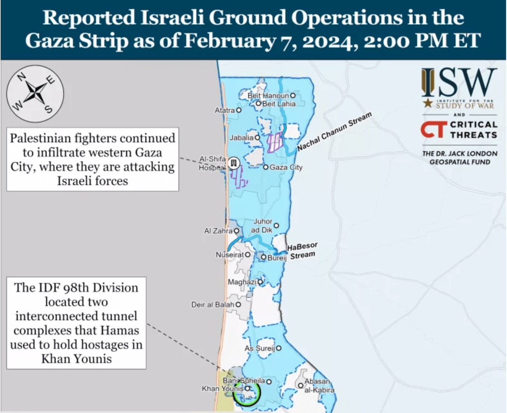
The Gaza War was explained in no uncertain terms as the destruction of this hidden network in which the terrorists who planned the attacks of October 7 could be extirpated from the region of the Gaza Strip, as if independent from the humanitarian needs of inhabitants of the Gaza Strip, in a sort inexorable logic that leads to no apologies, but exists as an imperative that is the only narrative frame for bringing the war to its conclusion. “Dismantling Hamas’s underground strongholds in the north, center, and south is a significant step in dismantling Hamas, and it takes time,” we were clearly warned by Israeli spokesman Rear Admiral Daniel Hagari, in late December, 2023–aware of the intensity of bombing of hidden “nerve centers” of Hamas, but unaware of the visible brutality wreaked by the tremendous–and perhaps truly incommensurate–destruction above the ground. If Israel has destroyed many “cross-border” attack tunnels that extended some two hundred meters into Israeli territory both in 2008, 2012, and in 2018, the extent of tunnels that were celebrated in Al Jazeera back in 2014 for their ability to store weapons and shield Hamas leaders from air attacks as well as link the Gaza Strip to Egypt–and long designed a site of resistance to Israeli sovereignty.
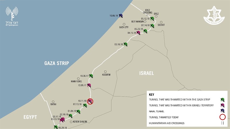
IDF demolishes Gaza attack tunnel that penetrated 200 meters into Israel |  The Times of Israel

Destruction of Tunnel Network Dug into Israeli Territory/October, 2018

For as the network has grown as the governance of the Gaza Strip has shifted, expanding as a form of hidden sovereignty able to endure attacks and escape Israeli vigilance and guarding of borders of the enclave. Although “mapping tunnels in Gaza right now is not going to happen,” the tunnels have become the elusive map of power in the Gaza Strip, a “big reveal” that has become the focus of the war, revealing the terror of porous borders that were echoed by the discovery of five Hezbollah tunnels on the Lebanon-Israeli border in 2018, in a military operation, that seems to seek to frustrate the Israeli Defense Forces’ charge to “defend Israel’s borders, since the formation of the Israeli Border Police in 1948, immediately after the foundation of the state of Israel–a Border Police who have long worn the Green Beret, signifying their status and crucial military role, symbolizing the “Green Line” drawn on the early maps of the Armistice of the first Arab-Israeli Wars of 1949, the pre-1967 border that have been taken as contravened by illegal sites of construction. If the Border Police have long imagined “peaceful borders,” the nearly 20,000 structures built along the border of the Green Line were viewed as a “ticking bomb” in the West Bank after October 7 invasion.

Years before the invasion, fears were raised by the scale of apparent bloom of illegal projects of Palestinian construction in Judea and Samaria, assembled by a combination of GIS mapping and aerial photography, as well as field work, that tracks the huge increase in “illegal” construction in 2022 in areas of Israeli jurisdiction by 80%–some 5535 new structures being built in 2022, an 80% increase over the construction in the same area in 2021, that are far from makeshift shacks.

Construction of “Illegal” Palestinian Housing in 2022/Regavim

The construction of what has been deemed strategically placed projects–and can be shown as such in maps of the region above–seem designed to hem in the settlements of Israelis around the so-called “Area C” of the Oslo Accords, if they might also be seen as overflowing the narrow areas allotted to Palestinians. But the huge construction project suggests an influx of cash, that might be seen as analogous to the creation of a costly network of tunnels by Hezbollah on the Lebanon border and in the Gaza Strip, as ways of challenging the stability of borders, and indeed the security of borders that has long been central to Israeli identity, and has become an accentuated topic of public concern in recent yeas–and least because off increased rocket attacks in Israeli territory.

In recent years, the ramping up of cross-border vulnerability of unforeseen proportions has placed the nation on tenterhooks that rendered most major Israeli cities vulnerable from the Gaza Strip with the rockets of Islamic Jihad capable to reach targets in Israel one hundred and fifty miles away, and escalated fears of the increasing proximity of the Gaza Strip to Israeli cities–long before the raid into Israeli territory concretized the fears of cross-border vulnerability in nightmarish ways.
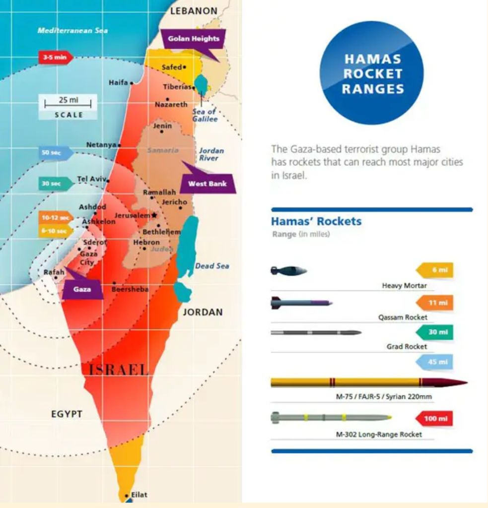
Rocket Ranges of Hamas from Gaza Strip, 2022/Jewish Virtual Library

The same alarmist catalogue of the weapons that were posed at Israel’s cities by a range of rockets from the international market–Qassam, Katyusha, GRAD, and Iranian M-302, M-75, and Fajr-5–were suddenly aimed by surrogates at ranges to reach m-and Israeli populations in Tel Aviv or Jerusalem–were mapped, of course, by the IDF itself, who are tasked to guard Israel’s borders. as an armory poised at most all of Israel’s cities, far from the Gaza Strip, a decade ago. But we had the illusion, or geographic imaginary, for a decade, that those dwelling near the Gaza Strip were as protected as anyone else in the nation, and did not suffer any special degree of vulnerability.

The Deadly Arsenal of Hamas,Israel Defense Force, 2014

map returned to tabloids and newspapers in Israel after October 7, questioning the ability to allow such intensive proximity was haunting the Middle East. The increasing density of the projects of technically “illegal” housing was not a proxy or basis for cross-border attacks, or for firing rockets. But the worry of destabilizing borders by occupying such “seam zones” on borders grew, as they seemed to reveal a long-term strategy after the invasion of October 7, not even twenty-five kilometers from Gaza, and was worried in the days after October 7. The fears Israelis would be hemmed in would be potentially explosive if Israeli military presence in Area C was withdrawn, as in Gaza Strip from 2005; any Peace Talks, it was feared, that would sanction a Palestinian State would have to lead to recognition of their legality and potentially set the stage for a similarly catastrophic invasion of borders, as the rhetoric of an imperative of securitization grew.

Construction of “Illegal” Palestinian Housing in 2022/Regavim

They deep fears that the invasion of October into Israeli territory triggered and made palpable fears of a violation of Israeli boundaries in ways not previously imagined–and could only imagine after October 7. The fears that such an invasion could be facilitated by an existent tunnel network in the Gaza Strip the have defined the “goals” and prerogatives of the Israeli army to destroy, even if their danger is contested and not readily seen. And if we project such tunnels as a “satellite map,” we are preserving the false illusion that we even know their scale, or can “map” the network as part of the landscape–even if they are indeed part of the geopolitical landscape of the Middle East.

For the underground Islamic Jihad tunnels, lying far beneath the ground, and not able to be “seen” or mapped in any actual manner, the tunnel network remains largely figurative, spectral, and assembled in partially from old surveys from previous invasions of the Israeli Defense Forces, offering a poor proxy for targeting, but providing a terrible image of a hidden enemy, unseen and impossible to measure. As the earth that as extracted to construct the tunnels was dumped offshore into the Mediterranean, making it difficult to quantify the scale of earth excavated by tunnel-makers, or the scale of a network that has offered a basis for the Palestinian terrorists in the Strip to survive aerial attack, and indeed to keep the civilian “hostages” taken from Israeli territory under concealment–even as the “tunnel network” is also widely mapped in international news.

The web of Gaza tunnels complicating Israel's possible ground invasion

If we are shown “Hamas’ Secret Tunnel Network,” “Hamas’ Tunnel System,” or “Gaza’s Underground Labyrinth” in respectable news sources, and “Hamas’ Huge Underground Network” in somewhat salacious terms of more popular news sources, the secret spaces of these underground caverns have a truly Alice in Wonderland-like quality of an underground storehouses, or hidden hideouts, worthy of evil comic book characters, and apartments, tied to shafts, elevators, and other concealed openings, existing under the street plans of the city, as a “city beneath a city,” and even imagined as a future terrain for military combat, hand-to-hand wars, or the future zone of conflict.
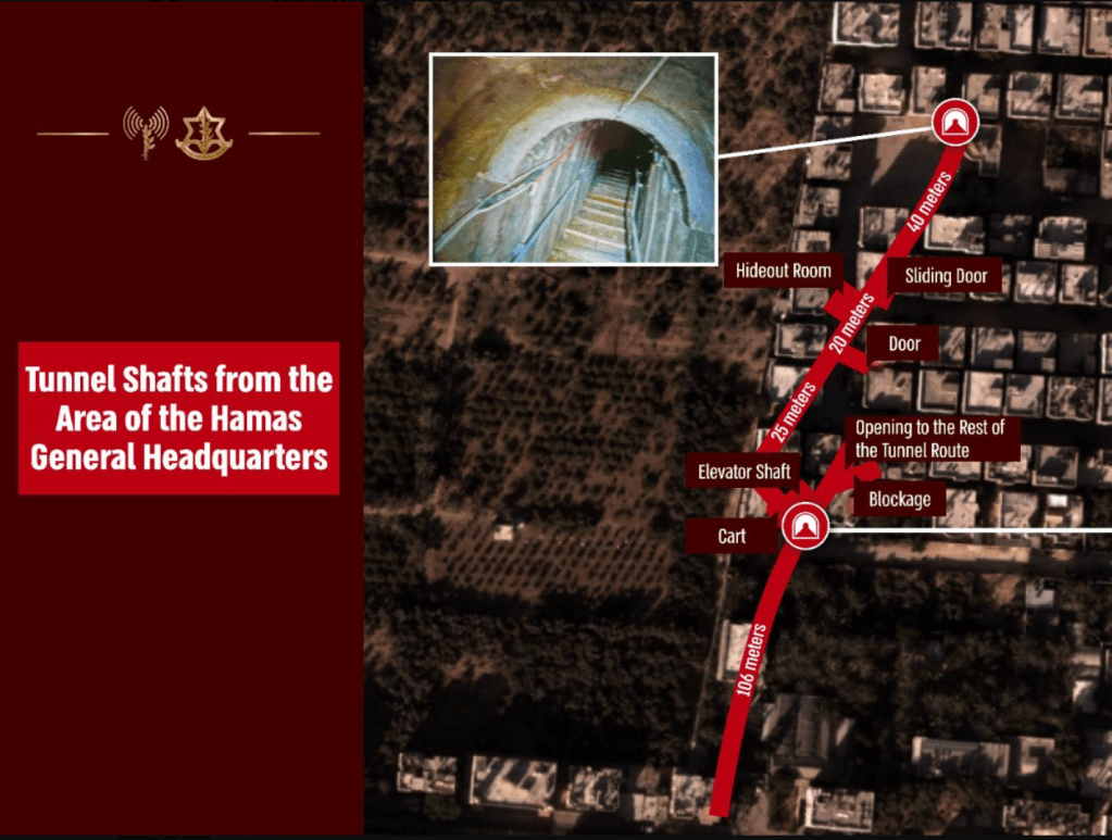
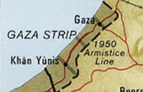
1. The tunnel network is a remapping of the boundaries that are formally imposed around Gaza Strip. Although it is odd to see them as a form of counter-mapping against the claims to sovereignty in Israel’s boundaries, they are just that. For the tunnel network, if begun as an economic necessity, has been expanded and exploited to as a basis to deny the limits formally imposed by the 1950 Armistice Line, which has perhaps provided the basis for the energetic chants heard in public spaces across the Western world, to Free, Fee Palestine, that invest a coherence in the currently occupied territories as an enslaved region that has been left at the mercy of a “terrorist state.”

The Armistice Line concluded after 1948 Arab-Israeli Wars did not invest territoriality in a region–

–but recorded a status quo of sorts later preserved in the Peace Accords and 1955 Armistice Agreements at the height of the Cold War, a stalemate of sorts between global powers, to be sure, understood and enshrined in maps along the original reference points of a historic Palestine Grid–

1950 Armistice Line and 1955 situation of Gaza, Mapped within Palestine Grid

–whose construction was, to be sure, the legacy of a colonial or quasi-colonial movement, drafted by the English on the model of their own OS maps as a way of preserving the spatial organization of archeological ruins, but that have created a framework to what is misconstrued as a religious war.

The provisional line that was drafted at the foundation of the State of Israel, and provided the orignary boundaries of the state that was guarded by the IDF, as the persevered the territory that was newly mapped in terms of a UTM projection that extended, as the timeless liturgy of the Prayer for the Israeli Defense Forces suggests, and increasingly patrolled by IDF forces in order to contain threats to the security of Israelis living near the region, as well as the increasing number of settlers near the border. The mapping of the expanded boundaries of the Gaza Strip to deny access to the outside world or to Egyptian neighbors is nothing less than a classic micro-macro point of tension in global geopolitics–“over our land and the cities of our God, from the border of the Lebanon to the desert of Egypt, and from the Great Sea unto the approach of the Aravah, on the land, in the air, and on the ground” in existential terms–even if the 1994 construction of a barrier between Gaza Strip and Israel was stated to be provisional, unlike the current claim to have created an “Iron Wall” that offers no clear basis for future discussion–and indeed seeks to force future negotiations from a position of power.

United Nations Palestine Map Showing Armistice Agreements between Israel& Lebanon, Syria, Jordan & Egypt, 1949-50

The current construction of a heavily fortified “Iron Wall” has provided the current crisis in which the framing of Israel as an occupying power has morphed into charging it as a terrorist state–a reflection of the very terms that Israel’s government charges Hamas, and given the events of October 7, seems to offer ample justification for doing so. The effective boundaries, however, provide the clearest basis for containing terrorist incursions has however not served the state.

The “Green” Line has been an internationally recognized boundary of the Gaza Strip, defended by the Israeli Defenses Forces as such, never intended to be designed or rendered as a border of sovereignty, but has been construed as a political or territorial boundary in local and global geopolitics. If drawn independently from claims to rights of Palestinians, a question kicked down the road to an unspecified date for future resolution by the global consensus, increased fortification defense of a militarized barrier that maps the Green Line as an actual border–

–that hinges on the perimeter fence. If it is design to limit global traffic it is unavoidably now treated as a border that demands protection to protect “our land and the cities of Our God,” as the prayer written in 1967 has it, that have perhaps enshrined the dating of the time-stamped “1967 borders” or “pre-1967 borders” as the basis for a “demilitarized” future, a fact that might be datable in terms of history of globalization–hearkening back to a time when the United States was an engine for almost half the global GDP, before the United States abandoned the gold standard, and before the waning of American global economic dominance of the postwar–the era in which the Universal Transverse Mercator was adopted as a model of a smooth global surface.

The network of tunnels that were dug under imagined border revealed its first porousness in 2005, with withdrawal of Israelis and Israeli troops from the Gaza enclave, and the expansion of a tunnel system that Israel had tried to contain. Increasingly seen as a threat to Israel’s sovereignty, the network has become a way of testing the borders that have emerged in an enclave once in 1955 tied to Israel by roads; the, contesting the so-called “Green Line” that divided Arab from Israeli sovereignty since 1950. If it is a sticking point in Palestinian peace accords, it is the stubborn site of the only survival of the old “Green Line,” the last line standing, that was set out in the 1949 Peace Accords, as a new “underground reality” emerged, not on most national maps, proved a way to erode–quite literally–a map seen as engraved in stone, contesting the original “demarcation line” seen and equated as an “original sin” of the “Palestinian Question.” While territories beyond the Green Line were not incorporated into Israeli sovereignty, the growth of robust tunnels along the contested “Philadelphi Route” running from the Gaza Strip to Egypt, was perhaps the original robust tunnel to smuggle weapons to evade Israeli surveillance, underneath the “security belt” Israel claims as a defensible border, as the tunnels appear to confirm an actual terrorist threat.

Hamas built tunnels to smuggle weapons under the Philadelphi Route from Egypt to the Gaza Strip. In recent years it has also dug attack tunnels from Gaza into Israel.

Robust Underground Tunnel of the Philadelphi Route from Egypt to the Gaza Strip

The “belt” is not a national border, or an international border, but has become defined as a “security border” analogous to the status of the Jordan Valley, by tactical terms first defined by the General who oversaw the victory in the 1967 War, critical to Israeli security–if not for its territorial identity. The bifurcation of the security border and national boundary at Gaza has grown as the boundary of the Gaza Strip become guarded as a border of Israeli territoriality, I argue in an earlier blog post, shifting understanding of Israel’s boundaries and their guarding. Guarding the Gaza “perimeter” is prioritized to securitize the borders of Israel for Jewish settlers who moved from the region beyond its walls, as new communities expanded beyond that perimeter, the tunnel systems have grown as an increasingly robust form of hidden governance, hidden from surveillance.

 If the network of tunnels first built to smuggle weapons in from Egypt in the 1990s before Israeli troops left, it expanded in depth and sophistication as Hamas gained control over the enclave and as it grew economically isolated, both as a network for importing goods and cross-border attack, extending five times below the depth of tunnels dug at the start of the new millennium, across a network claimed to extend over 500 km by 2021, according to propaganda videos of Yahya Sinwar, the length of the New York Subway, able to reach to Gaza City.  If the tunnels dug four to ten meters below ground seemed unstable beneath fifteen feet, the deeper tunnels are harder to sense by radar or to hurt by explosive force, as well as to detect from above ground–some over ten times as deep, if reports of 200 feet deep tunnel structures is true.  While the earlier smuggling tunnels of c. 2010 were closer to the surface and far more rudimentary in their framework and structural support–
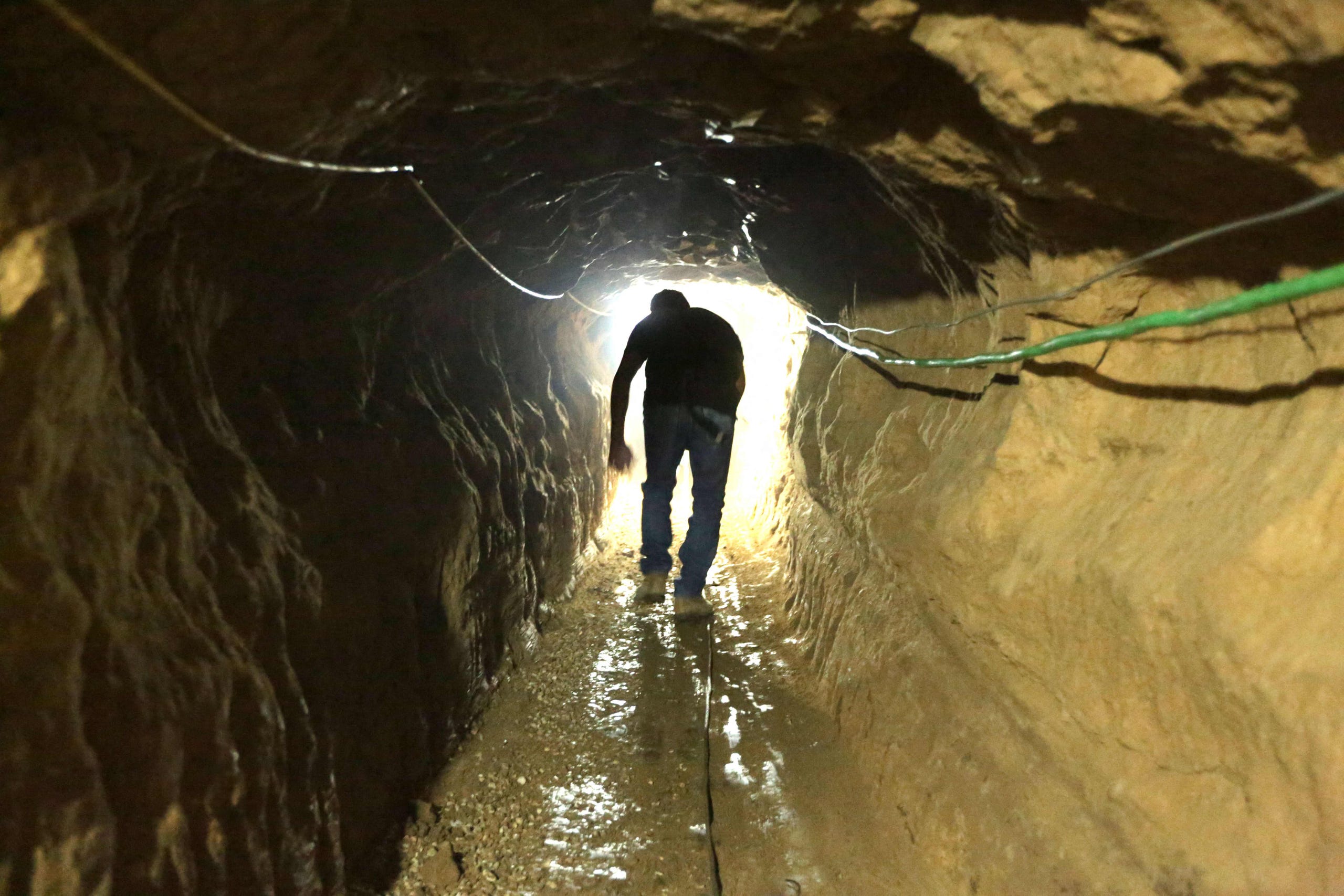
Palestinian Entering Reconstructed Bombed Smuggling Tunnel from Egypt, near Raffa, 2012/Patrick Bay, AFP

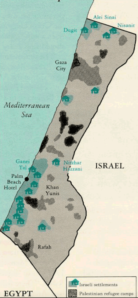
–the robust defensive and offensive functions that evolved of tunnel networks demand more careful discrimination in our maps, and are too often suggested as primitive networks imagined as able to be removed from the Gaza Strip–rather than forms of its current governance. The expertise in tunnel engineering by lego-like concrete blocks, ventilation shafts and soil compacters helped expand the engineering of an underground network tied to Hamas, and increasingly hoped by Israel to be able to be removed form the region, the offensive and defensive network has gained increased resilience. And as Israel’s right-wing government linked itself to the defense of adjacent communities near the wall, and tunnels targeting of Israeli forces or settlements near the border grew in response to a vision of sovereignty that exclusively defined the state for Jewish citizens-settlements mostly made for those Israelis who left the Gaza Strip in 2005, now lived in by a new generation of settlers, familiar with demanding protections for living outside a region composed of refugees before the current refugee crisis created by Israel’s invasion.

Israeli Settlements in the Coastal Regions of the “Gaza Strip” before 2005

Unlike the territory of Gaza or the Gaza Strip that is shown in surface maps of houses, buildings, roads and communities, the underground network of tunnels that extend across the Gaza Strip were long both the de facto network of Hamas sovereignty and the targets of Israeli invasion and air raids. The mapping of the tunnel network has shifted from a target of attack to its re-mapping embodying identification of the tunnel network as the underground nefarious form of negative-sovereignty by which Hamas has defined its presence in the Gaza Strip.  The metaphorical mapping of the tunnel network has served to embody an image of the “negative governance” of Gaza, and metaphorically mapped to delegitimize the authority of Hamas as a responsible governing entity.

2. The networks of underground tunnels that grew up to support Gaza’s literally “underground” economy as its borders were closed by Israeli Defense Forces in 2005 became, in 2012 and 2014, the targets of invasion and destruction–as airplanes targeted five hundred tunnels, some of hundred kilometers, as one that running from the South to Gaza City, by bombardment and ground operations–destroying 140 smuggling tunnels that evaded the Gaza blockade, including 66 tunnels used to target Israeli forces. The engineering of tunnels expanded to deeper and broader underground corridors to ferry cars of militants and reinforced by iron, with ventilation for larger mobilization, the network emerged in global consciousness as a new terrain of combat, and a new battleground lying far beneath the ground. Even if North Gaza has, as Israel insists, ceased to be under the sovereignty of Hamas from January 2024, the tunnel network dug beneath the territory has provided the firmest illustration of the survival and resilience of Hamas governance in Gaza.
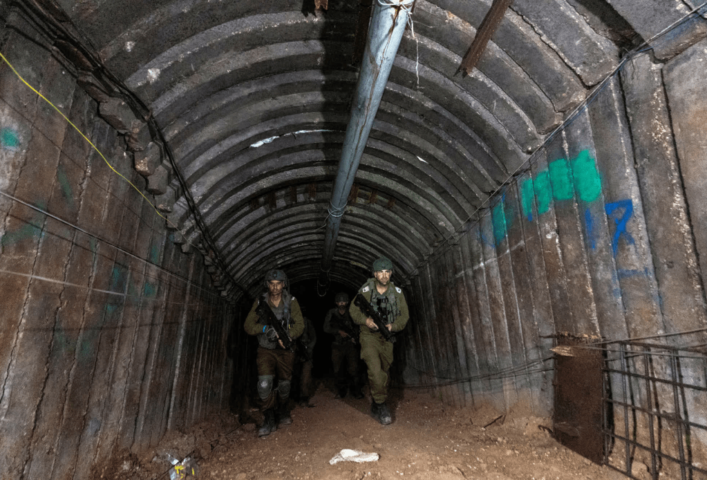
Israeli Soliders Patrolling Newly Discovered Tunnel at Erez Crossing, December 15 2023/Amir Cohen

Tunnel networks in the Gaza Strip have been long targeted as threats to Israeli sovereignty. From their beginning as cross-border passages designed to import weapons from Egypt into the Gaza Strip, the commercial network that Hamas encouraged since taking charge of the enclave in 2007 for incursion. The networks of underground tunnels that grew up to support Gaza’s literally “underground” economy as its borders were closed by Israeli Defense Forces in 2005 became, in 2012 and 2014, the targets of invasion and destruction–as airplanes targeted five hundred tunnels, some of hundred kilometers, by bombardment and ground operations–to cut the enclave off from external contact, destroying the excavation of 140 smuggling tunnels that evaded the Gaza blockade, including 66 tunnels used to target Israeli forces.

Yet if the underground network that has however grown as a dense network of resistance to Israel’s denial of the sovereign presence Hamas has created deep in the underground tunnels of the Gaza Strip, a difference not shown in many maps of tunnel routes–which show tunnels collectively, akin to surface roads of OSM maps, without distinguishing either the origins, depth, or status as a hidden infrastructure, equipped with electricity, internet access, and communications, that long served as a regional tax franchise. The elision of the different tunnels, and their different quality, flattens the history of the network, and indeeds elide its central importance in Gaza’s governance, by portraying it solely as a target of attack.

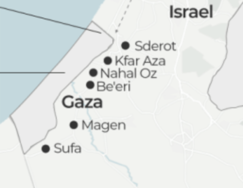
Gaza Strip in Maps/BBC/NPR

While these maps are entirely the product of Israeli Defense Forces, they flatten the emergence of the tunnel network, and flatten the entire process of constructing, funding, and using the network of underground tunnels demonized as a target of military attack. Since the rise of cross-border tunnels that have been sanctioned as targeting Israeli forces, contesting the sovereignty of Israeli forces beyond the Green Line, the tunnel network was targeted of a vision of sovereignty that was tied to the invasion of Israel, and increasingly responded to by defined the state of Israel as exclusively for Jewish citizens.

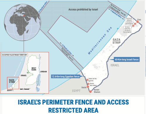
But as the tunnel network has become a target of Israeli attack, it has assumed figural status by cartographic logic both to undermine the symbolic identity of Gaza Strip. It has served to demonize the sovereign claims of Palestinians in the region, and an image of the negative sovereignty by which Hamas has defined its place in the Gaza Strip. To flush that presence from the enclave, or to attempt to remake the enclave separately from the enclave that was attempted to be isolated by the Israeli army as a threat–by a 60 km fence, Egyptian built fence, and patrolled harbor–

–whose destruction has been suffered by the Palestinians increasingly trapped between a map and a hard place indeed, as the specter of tunnel networks has come in a grotesque macabre of Grand Guignol to take precedence over their lives, a spectacle of destruction of homes, intent to define attacks on the neighborhoods of Gaza City by targeting attacks on an elusive underground network of tunnels independent of their habitation or of the cost to civilian lives.

Continue reading
1 Comment

Filed under Gaza Strip, Israel, national security, satellite surveillance, tunnel networks

The New Cold Warrior in the Triangle of Terror

When addressing the new Latin American policy in Miami’s Freedom Tower in late 2018, the new National Security Advisor John Bolton targeted Nicaragua and Venezuela in a striking geographic metaphor. He offered a new metaphor for described the dangers of a “triangle of terror stretching from Havana to Caracas to Managua,” in November 1, 2018, demonizing Latin America and the island of Cuba in terms that suggested possible plans for “taking direct action against all three regimes to defend the rule of law, liberty and basic human decency in our region.” As if to displace attention from the Northern Triangle from which so many asylum seekers have fled to the United States in recent years, including unaccompanied minors, and where civil society is overwhelmed by drug trafficking, gang violence, and police corruption, the new triangle Bolton seeks to shift attention is a target.

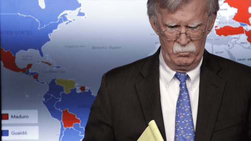
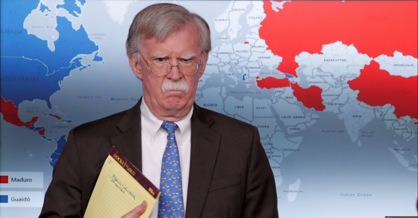
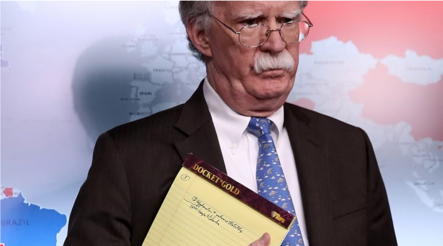
So it may have been no surprise that when attacking the legitimacy of Socialist Nicolás Maduro of Venezuela by imposing expansive sanctions ton Venezuelan oil and gas, Bolton seemed to tip the cards of power. Upping the ante from defining the Socialist regime of Venezuela as an apex in a triangle, in previous saber-rattling that committed the United States to striking a blow at a “triangle of terror” tied to the Socialist heritage of Hugo Chavez and to Raúl Castro, Bolton “appeared to disclose confidential notes written on a yellow pad” to reposition military troops to Venezuela’s border, standing before a global map the divided the globe in no uncertain terms, as if announcing a new configuration of power in his role as National Security Advisor for Donald J. Trump. The “triangle of terror” Bolton warned of in November 2018 seemed to essentialize the fundamentally dangerous notion a Latin American region ripe for instability. But it may have also been sheer coincidence that alliterative force of a rather pointless if powerful polygon was a powerful cartographic conjuring of a strategy of national defense, not located in the Northern Triangle, or the former Triangle of Terror where ISIS cultivated troops, but a new borderless triangle of even allegedly even greater danger–a triangle with a rich political genealogy from the Cold War.

Bolton’s adoption of the rare tired stock term of a triangle seemed to shift attention from the other Triangle of Terror, located when it was most recently in the news on the Afghan-Pakistan border, the very site from which negotiations have been announced to start to withdraw American troops. It may have been sheer coincidence, but Bolton seemed to shift attention from a triangle in the Middle East where American troops had been long stationed and that had been a hide-out of Osama bin Laden and Taliban fighters, as if by the powerful abilities of the friction-free nature of GPS–

–to a triangle that was closer to America’s own sphere of influence from the triangle of Peshawar, Quetta, and Kabul, from which the US was busy extricating itself. Bolton’s November speech was quickly taken, one might remember, as defining the intent of team Trump in relation to focus on a new Axis of Evil, adopting a hard line in Central America as sphere ripe for intervention–“This is not a time to look away. It’s a time to increase pressure, not reduce it,” Bolton announced–and the recent exercise of economic muscle to bolster American refusal to recognize the self-declared electoral victory of Nicolás Maduro, and to declare the legitimacy of Juan Guaidó as President of the nation, demanded a map to concretize the global geopolitical stakes that Bolton and Trump were ready to commit to Venezuela, although the map before with Bolton spoke revealed few of the roots for the focus on this new Triangle, but rooted confrontation with Maduro’s claims to legitimacy in the defense of democratic liberties.

Bolton cast the region as a geopolitical battleground for American interests in stark and rhetorically powerful alliterative terms. He openly opposed the United States to a “Troika of Tyranny”–a term that lexically hinted at a vehicle driven by Russia, but wasn’t the 2016 Presidential election–and almost openly evoked the chills or breezes of a new Cold War, with its division of the world to spheres of recognizing two possible Presidents in Venezuela in ways that expanded an electoral map of one nation to spheres of geopolitical influence–if not alliances–expanding in bizarre terms an electoral map to the world to show that it had global consequences–as if global power dynamics were as simple as an electoral map.

The infographic seems to advertise how much “other countries” had at stake in who was Venezuelan President, keeping mum as to why they did. It helped that Bolton looked the part of an inveterate Cold Warrior. And one could not but recall the openly proprietorial terms of last November, when he announced “Cuban military and intelligence agencies must not disproportionately profit from the United States, its people, its travelers, or its businesses” but pointedly attacked Venezuela by imposing sanctions on its gold, and attacking the “triangle of terror” or “troika of tyranny” perhaps metaphorically tied to a Bermuda Triangle, redolent with weirdly alchemical associations of unknown dangers near islands on the high seas–

–as if one could pretend that the declaration was about the rocky shoals of securing needed democratic reform and less to do with oil revenues and resources, as with the defense of democracy.

The transposition of the polygon of a triangle from Afghanistan to the hemisphere was close to a notion of hemispheric dominance, if it also turned attention from a long war in Afghanistan to a closer, seemingly more surgical, winnable military confrontation. The map affirmed the need for using economic muscle by seizing income from oil as a way to undermined as a Socialist dictator, however, whose socialist government was corrupt and based on cronyism, linked in the global map to authoritarian governments in Turkey, China, Russia, and Iran, and their allies, linking an argument of hemispheric dominance to broad geopolitical warning of the consequences of failing to recognize Guaidó as being Venezuela’s legitimate President in American eyes.

Bolton Declares Sanctions on Venezuela’s national oil and gas company at White House Press Briefing/january 28, 2019
Evan Vucci/AP

Maps often lie, as do infographics: but the international magnification of the lack of legitimacy Bolton had been preparing to declare for some time came not only with trappings of objectivity, but with a not so coded message, that might be the true legend of the global divisions in the infographic, and was the major social media take away: a proposed movement of US troops whose removal from the Syrian and Afghan military theaters was in the process of being negotiated by the Secretary of State: the image, unintentional or not, immediately raised fears and concerns about American military plans and sent a shudder in global media.

While it may have been sheer coincidence that the metaphorical migration of the triangle of terror from one theater of global confrontation to the next was occurring in Bolton’s rhetoric and was mirrored in the imagined frictionless switch in deployment of soldiers in the legal pad Bolton displayed to television cameras–

NSA Advisor Bolton’s Yellow Pad

The mobility of the metaphor and the military seemed to echo the new logic of the Universal Transverse Mercator map, where territorial boundaries and sovereignty have far less prominence than specific sites of dispersed geographic location, and imagined transfers of military power could be a frictionless motion in space.

The infographic provided a sort of parallel world carved up and divided by entrenched political interests but whose alliances helped sovereign boundaries to recede similarly. The global two-color map almost made it difficult to understand that he addressed Venezuela–the topic of his Press Briefing in January, 2019–save by the legend identifying red as “Maduro” and blue as “Guaidó”, elevating each man who had claimed the presidency as holding a global constituency, and dividing the globe to magnifying the geopolitical centrality of the Venezuelan election. In the early February State of the Union, Donald Trump elevated–behind the rubric “Abortion”–the pressing concern of Venezuela immediately after “National Security” and “North Korea,” in ways that similarly monumentalized the question of recognition of the future president of the nation, under the rubric of “never apologize for advancing America’s interest, moved from the Border to “National Security” and withdrawal from the Intermediate-Range Nuclear Forces Treaty, a historic arms control accord of forty years in standing–with the commitment to “outspend and out-innovate” all other nations in weaponry–to North Korea and Venezuela, regions that were almost designated as areas of future combat.

Trump’s pledged to the union in a mid-February address to “stand with the Venezuelan people in their quest for freedom” against unspecified enemies, but targeted dictators tinged with Socialism. The gripping evocation of a struggle against “the brutality of the Maduro regime, whose socialist policies have turned that nation . . . into a state of abject poverty” may have foregrounded the prominence of Trump’s interest in targeting Bernie Sanders and Alexandria Occasion-Cortez as Socialists, in order to taint the Democratic party. But it was also a crisis that recalled how John Bolton, his new National Security Advisor, had conjured a new danger for the United States’ geopolitical position, independently of nuclear disarmament treaties, but which evoked our historical need for intermediate-range missiles to protect domestic interests.

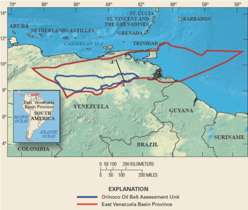
The role of Maduro in Venezuela has been disastrous for its citizens, to be sure, and mismanagement of natural resources by the state demands attention: But much as Trump distorted actual policies by targeting the “Socialist regime” of Venezuela in a speech marked by excessive flag-waving, patriotism, and rally-like chants of “USA, USA,” the prominent place of map before which Bolton spoke distorted the situation, by literally taking our eyes off of the ground. The map obscured the flows of refugees from Venezuela and the humanitarian crisis in South America, as well as access to the vast oil reserves lying beneath the Orinoco River basin’s Belt. The extensive reserves to which America has limited access is mapped by USGS, but was left tacit in the American declaration of sanctions, but motivating an abrupt change in returning attention to the Western hemisphere for the National Security Advisor. And the assumption of Venezuela as OPEC Presidency, as much as the defense of democratic principles, made the clear ties of National Security to the preservation of access to and production from the Orinoco Reserves–shown below by PDVSA–and the truly globalized investment in the fields shown below, estimated to include three hundred billion barrels of bitumen–the black, viscous, organic “sludge” that contains petroleum–in what are estimated to be the largest reserve on earth, involving multiple international players–from Statoil of Norway to ExxonMobil to Chevron to BP, but also CNPC of China and TOTAL of France, as well as even if the private ownership in the Orinoco Belt was ended in 2007 by Hugo Chávez, whose Presidency haunts the current crisis. But although nationalized in name, the project of oil extraction are only majority owned by he vast majority of bitumen remains too deeply buried for surface mining–some 88-92%–by Petróleos de Venezuela (PDVSA)–creating a site that was used by Chávez to finance social reforms and projects, and created revenues of $30 billion annually in 2011, making Venezuela a sort of bit of an economic bubble in a globalized world, tied to international markets for carbon and oil, and making Venezuela a “hidden” global petroleum power, estimated to have hundreds of billions of barrels of oil.

Petróleos de Venezuela (PDVSA)

The international ties to projects of extracting bitumen and refining oil in Venezuela–which produced about 2 millions of barrels a day in 2015–estimated to have far more technologically accessible reserves. The decision to amplify the level of rhetoric used to isolate Maduro and acknowledge Guaidó as President surely has close ties to the assumption of increasing attempts of national oil and gas company to reroute its oil supplies to Europe and Asia, as members of the Maduro regime told the Russian news agency Sputnik, not only responded to the sanctions, but undercut the Venezuelan crude that usually flowed to CITGO refineries in Texas, Louisiana, New Jersey, and Illinois which made access to crude that lay in Venezuelan territory a national security question–as Oil Minister Eulogio del Pino tweeted hopes to “continue consolidating strategic alliances between PDVSA and Rosneft” in November, disturbing images of hemispheric dominance, as well as undermining American energy security.

.

USGS has estimated 513 billion barrels lying in the Orinoco Oil Belt, without determining or publishing the proportion technologically or economically able to be extracted
Venezuela Oil Holdings – Deep Resource
CITGO’s Petroleum Terminals in USA/CITGO

Bolton’s–and Trump’s–description of Venezuela as an ideological struggle is all one sees in the two-color division of the globe that almost heralded hopes for a return to a Cold War where maps were understood primarily as a global battleground, recalling the days at which a vertiginous sense of power in postwar Europe led us to map exchanges of nuclear missiles, and imagine apocalyptic scenarios where the world was divided by global war–but a global war that seemed to really be about American interests on access to energy reserves, hiding behind the scrim of a ratcheted up rhetoric of democratic legitimacy.

The economic crisis in Venezuela is both tragic, and an acute crisis of humanitarian scope. But the global map seemed to reduce it into a global confrontation of two blocks, if not a crisis of global consensus about representation and political legitimacy, that seemed to hollow out the term of democracy of its content: despite national sovereign division in South American, the sharp divisions of the blue of North America and most South and Central American nations described inexistent international blocks of consensus. What seemed a legitimate record of global divisions about the crisis the legitimacy of the Venezuelan government to lay claims to Venezuela’s rich reserves of oil. Without acknowledging the political or economic actualities in the South American nation, the map hinted at a global crisis, its stark red v. blue color-scheme reflecting the offers of Russia to restructure the debt of Venezuela’s oil and gas companies, and China to lay claim to a stake in Venezuela’s oil, by asserting the reserves to lie within America’s hemispheric interests, and equating those interests as lying with America’s National Security.

As if to bolster Guaidó’s claim that he is backed by the democracies of the world–in ways that nothing better than an infogram can attest–

Just 25% of the world’s governments have publically recognised Guaido as President; the remainder recognise Maduro’s election
(Paul Dobson / Infogram.com/February 6, 2019

The map before which Bolton spoke has become a topic of recurrent interest, as the nature of the global divide has been parsed and examined. The divide, this post argues, was less an informative one–deisgned to generate debate–than to paper over the situation in Venezuela’s political crisis as a question of alternative candidates for President, treating the contest as an election, and using the colors of an electoral map to suggest that the election was conclusive, and the legitimacy of Guaidó reseted on clearly ideological foundations.

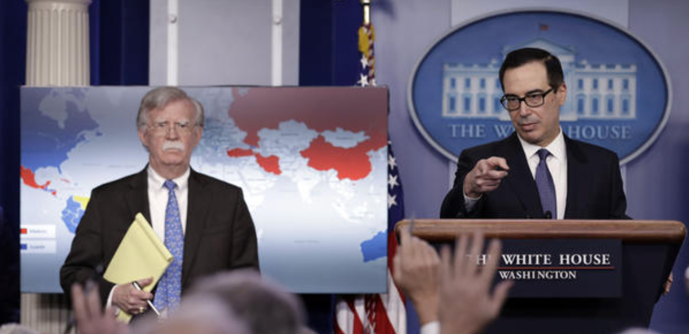
Bolton spoke at the White House briefing before a map revealing a broad global divide ostensibly about recognizing Maduro’s legitimacy as Venezuela’s President but that hauntingly recalled the geopolitical divide that was firmer than many since the Cold War. It provided an image of the Cold War as it was seen from Washington, in some way, as if ideological divides that are clearcut still maintain legitimacy in a globalized world. The infographic on two screens seemed to affirm the broad global consensus of questions of the legitimacy of Maduro’s government, as if this justified the decision to block access to all property located in the United States of the national oil and natural gas company, Petróleos de Venezuela, S.A. (PDVSA), place its assets in escrow, and prohibit American citizens from paying the company directly for access to unrefined or refined oil assets. But the “press briefing” was also a transformation of the White House into a new newsroom of sorts, that exposed the illegitimacy of the Maduro government through a map that tied the United States to the defense of democratic principles–coded in blue, with other democratic allies, in opposition to “reds” linked to Socialism or Communism–China, and Russia, even if it was not Soviet, but also some questionable allies–that reinstated the for-us or against-us global space to make a point. The disclosure before this map of a threat of sensitive statement that echoed a bespectacled Bolton’s assertion that “all options are on the table” provided a powerful infographic that tied Washington to an image of legitimacy, even if the awfully crude map lacked legitimacy to orient American viewers to global affairs.

The new global imaginary that Bolton promoted as he stood beside U.S. Treasury Secretary Steven Mnuchin painted a global schism as the consequence of Maduro’s declaration of his victory in a second term as President, as a violation of that nation’s constitution–and as standing in violation of the Venezuela’s constitutional elections–but was as much a response to the defense of a restatement of American economic sovereignty in the Western hemisphere, a phrase going back to the turn of the last century, if not the Monroe Doctrine, but which gained new currency in the Cold War as issuing from the Dept. of State, and as a question of national security rather foreign affairs, by tactically magnifying the geostrategic role of the Venezuelan election, rather than offering evidence of a constitutional argument about sovereign legitimacy. The question of sovereignty seemed intentionally blurred, as the Secretary of the U.S. Treasury took questions about sanctions against a foreign state-owned oil company, currently OPEC chair, whose assets were being frozen to promote democratic legitimacy, but in fact to strengthen America’s hemispheric dominance.

This time, the map–whose stark divisions into blue and red blocks suggested a map of American alliances, echoing an imaginary of detente, rather than legal rights–seemed to place the defense of denying the flow of economic goods from American territory as a globalist argument, by reframng the issue of constitutional rights or legality in globalist terms that preserved an image of American dominance within the color scheme that it divided the world.

And National Security Advisor John Bolton, who in less than a year in the Trump administration has become an advocate for military interventions in both Iraq and Iran, used the briefing before a map to raise rather openly the possibility of a military resolution of the crisis over the Venezuelan Presidency, as the Commander of US Southern Command, General Mark Stammer, is set to meet the Ministry of Defense of Venezuela’s neighbor Colombia, and Maduro has conjured fears of a “coup” driven from the United States. But the fear that the invitation of American oil companies to organize the refining and extraction of Venezuela’s abundant crude reserves after the January 23, 1958 Democratic uprising, just before the Cuban revolution, sent shock waves into the United States, pushing the Trump administration rather precipitously into a search for infographics that could substantiate dangers of infringement of its hemispheric interests and geopolitical dominance, and to convince the world of the danger of Maduro’s disenfranchisement of elected members of the Congress, and the lack of legitimacy of a regional vote that supported Maduro’s government against a fractured opposition–and led to the invitation from Russia to restructure the state-owned oil and gas company’s massive debt, recasting the struggle about the government’s legitimacy into new global terms.

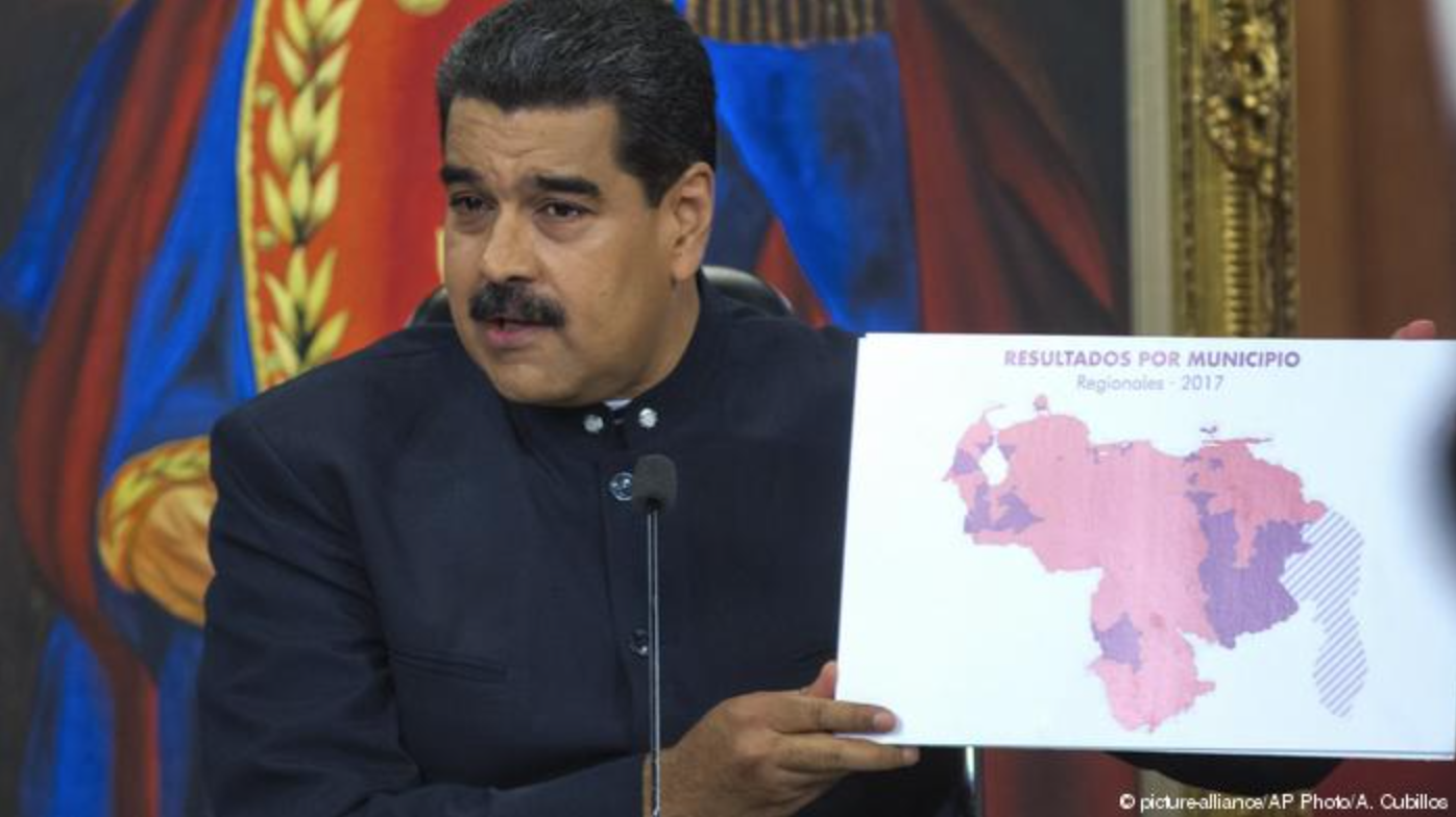
The colors on the global map reflect, to be sure, the contested results of elections in Venezuela, where compromised elections had produced the heavily disputed endorsement of Maduro’s Presidency just last May. After an offer from Russia to restructure the massive national debt in November, 2017, Maduro declared new elections in May 2018, which the opposition decided not to recognize, and which polls suggested he wouldn’t win, but in which he was victorious–coincidentally at the same time thatJohn Bolton gains the portfolio as director of the Trump NSA.

October, 2017 AP/A. Cubillos
2017 Regional Elections of State Governors in Argentina
Distribution of votes for Maduro in the election whose low turnout led its legitimacy to be quickly questioned by the EU, US, and OAS

Familiar blue v. red electoral maps were used to describe the votes of the Great Patriotic Pole and opposition  Coalition for Democratic Unity that were recast suddenly in global terms in late January in Washington. Socialist Maduro affirmed independence in his inauguration, and in rebuke Parliamentary President Guaidó won immediate support from Donald Trump after he declared himself Interim President and leader of the nation and of oil company, precipitating a powerful infographic to be devised in Washington that oriented audiences to an electoral map in global terms. But for Trump–and for Bolton, who cast the election as a question of National Security–the global divisions in globally strategic terms.

Trump’s segue in his February 7 State of the Union from the INF to Venezuela, included a transition about North Korea, but suggested global imbalances that any obscure the question of access to petroleum reserves in Venezuela, and the deep, implicit question of whether the American military should or would be used to guarantee access to Venezuelan oil. In ways that must have crossed Bolton’s radar, but have faded from most public comments, Maduro when he pledged to decouple the pricing of Venezuelan crude from the dollar, use of non-dollar currencies as the Chinese Yen for Venezuelan oil, and seeking to cut oil production to “stabilize” oil prices–and entertaining the cryptocurrency Petro, based on the five billion barrels of oil found in Field No. 1 of the Orinoco Oil Belt–possibly less than a quarter of Veneuela’s considerable total oil and gas reserves, whose accessibility to the American economy has suddenly become increasingly tenuous.

PDVSA

The events tied to the assumption of the Presidency of OPEC led to ‘slow coup’ of January 23–the anniversary of the overthrow of the Jiminez dictatorship by Venezuelans in 1958–as opposition politico Juan Guaido auto-invested himself with the presidency with broad American support, followed by a chorus of right-wing governments in Latin America, including Brazil’s Jair Bolsonaro.

The result was to pretend that the elections which the opposition party had boycotted last May could be cast again as an electoral map, this time not involving Venezuelan votes–or the self-determination of the nation–but symbolically recasting the election in terms of a global map. Even as Maduro offered to negotiate, he bristled “The presidential elections in Venezuela took place, and if the imperialists want new elections, let them wait until 2025,” perhaps reacting to the provocative recasting of the national elections, whose legitimacy has been questioned by observers, in ways that led Bolton to take to Twitter to threaten “serious consequences for those who attempt to subvert democracy and harm Guaidó”–as if he were the victor of an election. Bolton had escalated attacks on the “legitimacy” of Maduro from mid-January and the “illegitimate claims to power” of the Venezuelan “dictator” as abrogating the “a government duly elected by the Venezuelan people” and democratic practice. But the stark divide of the global map seemed to resist any discussion of negotiations and affirm the United States’ ability to shift troops from Afghanistan to Venezuela’s border immanently–while preserving something of the illusion that the “blue” votes for Guaidó would be affirmed by American muscle.

Win McNamee/Getty Images, off CBC

The gruff determination and stoniness that registers in Bolton’s face as he sought to communicate the divisions of the world that potentially lay in the failure to affirm America’s recognition of Guaidó bled far beyond the defense of democratic principles, and seems to have threatened to cast more than a shadow over Europe. Bolton’s slightly veiled message of national security seemed, in classic America First style, to cast a shadow over European allies, here symbolized by the actual shadow that his pensive head cast on the United States’ traditional NATO allies.

Was Bolton in the act of forging global divisions of a new Cold War, military detente and hemispheric dominance, sneakingly if all too familiarly tied to defense and affirmation of democratic principles?

Continue reading
Leave a comment

Filed under geopolitics, latin America, national security, news graphics, Venezuela

Specters along the Interstates: Mass Incarceration and the Geography of Fear

What seemed a terrible corrosion of public discourse before the mid-term elections is difficult to attribute to any single cause, person or a single election cycle.  The ominous staccato of alarms at the arrival of improvised pipe bombs sent by mail to prominent Democratic party figures and Trump critics were readily visualized across the nation as a disruption, the degree to which the man who had sent them, Cesar Sayoc, existed in a hermetic world of Trump slogans made the map of destinations less relevant in comparison to their relation to the toxic tweets our nation’s President has directed to immigration as  a threat to the national security.

Raising the specter of criminals and aliens–and profiling all refugees as criminals for crossing the border illegally–as an invasion of our territory, even if no members of the Caravan had approached the border, the Commander-in-Chief allowed it was not ‘conceivable’ the Caravan did not terrorists from the Middle East among their midst–and exposed the nation to a disconcerting word salad of apparent free associations in which “caravan after caravan” would be invited to enter the nation should Democrats gain majorities in mid-term elections, foretelling “a blue wave will equal a crime wave” in late October in clear attempts to disconcert and disorient in a haze of heightened paranoia in time for Halloween, not protect our national security.  But the specters that he provoked and elicited are not only empty charges, but permeate our society, fears of subjects that are often perhaps not cast in such openly political terms of oppositions between parties–“a blue wave will equal a crime wave; and a red wave will equal law and safety,” but exist in our landscape.

They exist in the huge diffusion of mug shots and Most Wanted images that jump outside of the confines of Reality TV as something like click bait–online images that have migrate to billboards or into the separate sections of small print newspapers–and instill a fear of the violence of those operating outside of the law, and are mirrored in how the us v. them categories existed in growing numbers of imprisoned within our borders, and the fears of fugitives stoked in billboards, and indeed in the growing epidemic of incarceration that feeds the idea of the criminal, and indeed of an expansive category of criminality, that has haunted the United States, and is perhaps magnified as an interactive spectacle both in the growth of Reality TV shows as “America’s Most Wanted” and the digitized billboards promoting the apprehension of fugitives along the interstates–and the fears that Donald Trump promotes of “murderers and rapists” at our borders, now with terrorists as well in the mix.


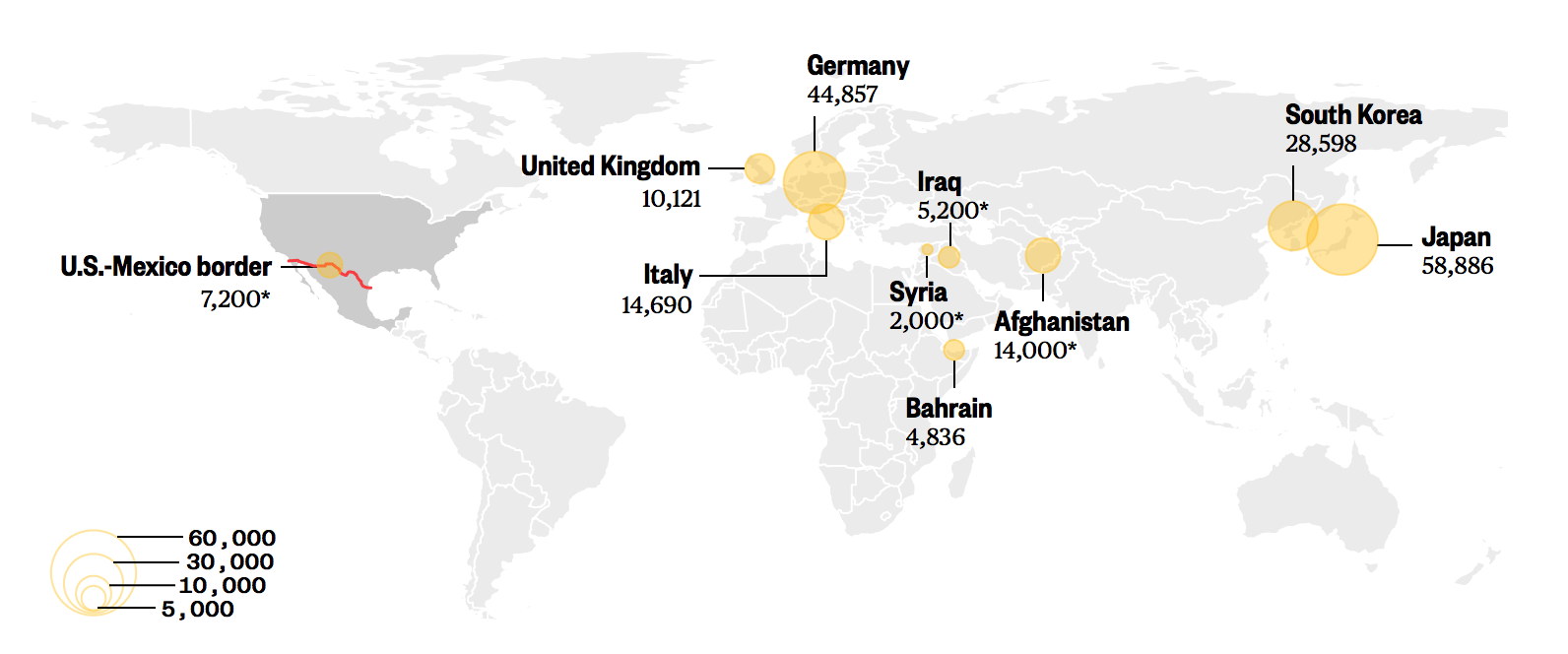
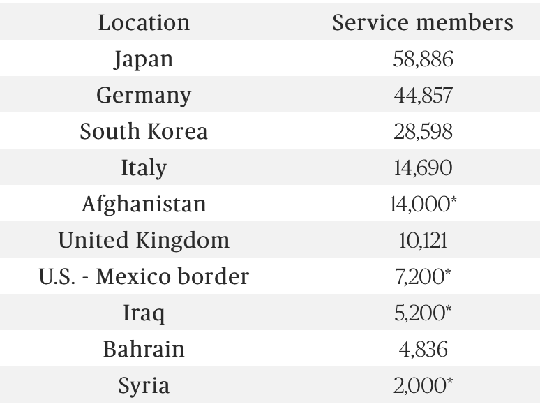
The repeated invocation of national security concerns, to argue those seeking asylum constitute threats to the nation, stand to change the United States from a place to seek sanctuary, ordering 5,000 troops–and perhaps up to 15,000–to the border with Mexico to bolster Border Patrol forces, and add more concertina wire, as he tweeted to refugees the “you will not be admitted into the United States unless you go through the legal process” and called their approach in no uncertain terms “an invasion of our Country” for which “our Military is waiting,” before Halloween, sending more troops to the borders than as are stationed in Syria and Iraq combined.  This military mobilization set the national atmosphere on edge on October 31, 2018, focussing our military presence on the border in a way no Commander-in-Chief has ever done.  The alarm that we should all feel at the bulking up of a military presence in a zone that lacks any actual combatants suggests a sick hollowing out of the value of military missions globally, not to mention military morale.


United States Troop Deployments on US-Mexico Border (expected) and in Afghanistan, Syria and Iraq on October 31, 2018; other numbers from June 30


The civil disruptions that had occurred within the country were taking up most of the media, but were hard to map, even though they were bound up so tightly in delusions and fears that spun from the border.  Cesar Sayoc was accused of mailing poorly improvised DIY pipe-bombs that were thankfully badly improvised, and found before they arrived in the hands of their destinations or exploded; but fears spurred by their arrival at multiple sites across the nation echoed maps of “sprees” of terrorizing pipe bombs in the past.  This time, they revealed the terrifyingly captivating nature of alt-right discourse even as they seemed destabilize the nation by attacking individuals.  Even if they didn’t explode, the sequence of bombs revealed tears in our political and civil space–and of a politics of demonization, targeted at how Trump had designated  dangers to the state, and of fear more than hope or civic involvement as we knew it.

The rash of violence that we couldn’t help but map to try to make sense of it, and it was viewed as a national wake-up call and emergency that it was–


image.png


–unfolding over a series of days in one week, either because of the vagaries of the U.S. Postal Service, or the actual intention of their maker–which seems beside the point–as the impression that they created of a plague of violence, tapping into the repeatedly foiled plots of terrorist attacks, ranging from teenage with contact to Al Qaeda to the twenty-one year old accused of planting twenty-four pipe bombs which would form, connecting their dots, a smiley face that would stare back at the viewer, whose smile was to arc from Colorado to North Texas to Tennessee.  If the latter used a map to plant pipe bombs in mailboxes that would create a giant “smiley face” so that the map would stare back at the nation, the map stared back as a staccato punctuation of the civil fabric, even if they did not explode or injure anyone.


Cesar's bombs map USA


Their progress raised alarms and confusion as to the uncertainty about what was to come, and if the illusion of civil peace could be sustained.  The planned set of attacks that seemed to destabilize public discourse was born out of Donald Trump’s head–who else links George Soros and Tom Steyer with Cory Booker, Eric Holder, Jr., Bill and Hillary Clinton, Joe Biden, Jr., Maxine Waters, Michael Moore, Kamala Harris and Robert DeNiro?–even as they seemed to tip an already uneasy nation over a brink of whatever decorum remained.  They seemed to threaten to rend the very fabric of the nation, on the eve of the midterm elections, as the arrival of  sent pipe-bombs planted alarmist messages and reminded us of the increased escalation of oppositional rhetoric in United States politics, as these anonymous acts of terror created a terrifying instability of our civic space.

There was twinned let-down of tensions and a terrifying realization as the man who sent them, holed up in a white van in Florida so covered with Trump-Pence stickers aptly characerized as a MAGAmobile–whose inhabitant seemed to have spent the last two years in the virtual world of an online campaign, drawing sustenance from the ideological slogans of Trump’s campaign.  Sayoc made bombs that failed to explode, probably from downloaded instructions, in a van with windows were so fully covered in garish divisive slogans they had effectively obscured any relation to a real world.  The pipe-bombs spun from the frenetic identity of an online discourse, allegedly used in the subsequent massacre of Jews, a mass-murder at a Pittsburgh synagogue, driven by fears of immigrants and the promotion of immigration as if both were dangers in danger of “suspected terrorists” destabilizing the state.   Trump has erased all integrity when with recognizable narcissism he described how both both of these tragic events served to “stop a certain momentum” going into the elections, as the acts of “two maniacs” he energetically disowned, as if they had shifted attention from the impact of GOP theatrics when they only shone a light on the dangers of Trumpets rhetoric and re-examination of his tweets  in relation to the nation’s psychological health.


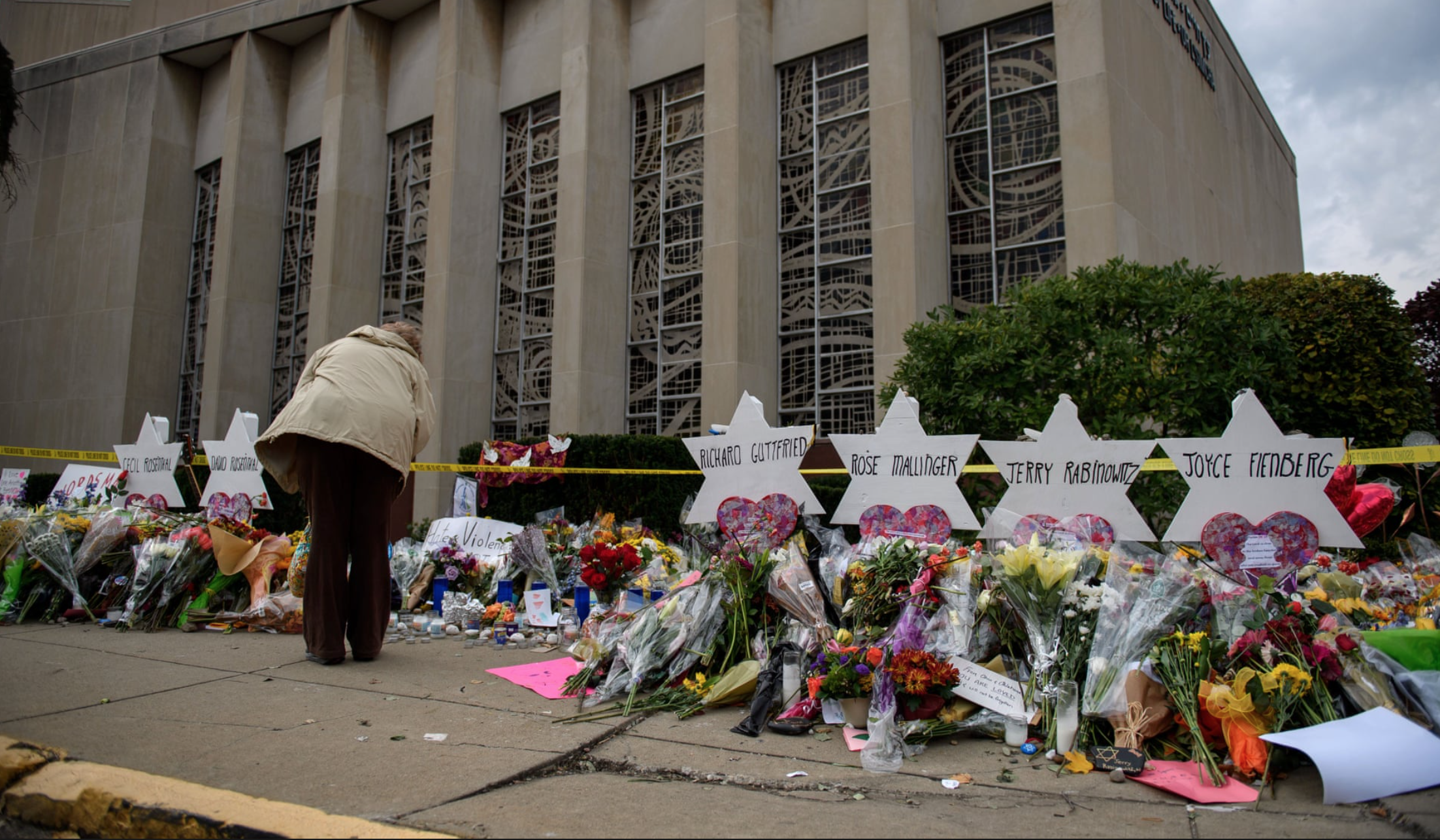
1. The bombs’ destinations may be a bit revealing, even if maps couldn’t capture the tragedy, or reach the violence Trump’s oppositional rhetoric plants in our civic space.  The pipe bombs were sent where media hubs of its coastal states, which President Trump has indulgently attacked as “elitist,” in an attack on cosmopolitanism and coastal elites–and the mapping of such regions to members of the Democratic party seen as especially dangerous to the nation.  The geography of the bombs was less striking than their destination for the coasts–the eastern seaboard, but also the western in California–coastal sites in “blue states” that Trumpists have distanced from the heartland, sewing divisions in the nation.  The sequence of a week of pipe bombs was terrifyingly followed by a terribly  violent attack killing and maiming members of a Pittsburgh Tree of Life Synagogue before Shabbat services, allegedly after crying “All Jews must die,” as if mainstreaming the need to defend the ‘nation’ against immigrants seen as terrorists.  Joseph Bowers’ social media post on his intentionally unmonitored Gab–“I can’t sit by and watch my people getting slaughtered”–used its alleged protection of “free speech” to ready himself to open fire upon innocent congregants.  The killings mapped the distortion of reason on a platform that wanted ideals of free speech, promising to “promote raw, rational, open, and authentic discourse online,” and would defend the best response to hate speech as more speech.  Even though the two men had never met–and didn’t know of one another–they were triggered and animated, as Noah Berlatsky notes, by a common manufactured fears of migrants, and an antisemitic attribution of assistance for immigration and animosity to globalist Jews, and left the a good part of the nation mourning or in shock.


Memorial outside the Tree of Life synagogue in Pittsburgh, where 11 people were killed. Jeff Swensen/Getty Images


Unmonitored platforms may create alternate worlds, but cannot radicalize, even though no platform for attention of such heinous attacks should exist.  No space should allow calling for violent acts or promote the fostering of violence.  And as I traveled outside Berkeley, CA, where the absence of civility in the nation is at times hard to map–I was struck by the proliferation on the side of freeways of strikingly analogous oppositional rhetoric is evident in the proliferation of specters of fugitives, frozen in mug shots placed in digitized billboards, as a broad expansion of our notions of criminality:  by advocating a public sort of retributive violence, the specters that increasingly haunt the interstate in such digitized billboards allow drivers to enter versions of “America’s Most Wanted,” the old television show FOX created and endured so long on air, while behind the wheel.  The direct engagement of such an oppositional rhetoric of danger seemed outside the political world–it was from a federal law enforcement agency, after all, but triggered a deep sense of unease that is echoed in the fear of outsiders and rampant criminality at our gates:  as Vice President Pence intoned quite surreally and without any proof that it was all but certain terrorists were among the Caravan of central American refugees and migrants approaching to seek asylum in racially charged terms–“It is inconceivable that there are not people of Middle Eastern descent” who would “not be in this large throng” approaching the border, in defense of Trump’s outrageous claim“Middle Eastern” people will emerge among the migrant caravan if you “look with cameras” and his instructions to the press to “take your cameras, go into the middle of the Caravan, and search” for MS-15 gang members, Middle Easterners.  In these ungrounded assertions, the danger of refugees was linked to those who the President, as Rebecca Solnit wrote, had pushed the nation, but also Bowers and Peyoc to focus on.

Driving to an airport in Newark, NJ, I couldn’t but think of the new means of civic involvement–based on fear–that has spread in the nation, as the face of a glassy-eyed fugitive from the law jumped out from other surrounding signage, as if the digital billboards of wanted criminals drew attention to targets of public wrath and danger,–their identities were obscured by their felonies, as the terror of their crimes seemed a means of striking fear into my heart, as it suddenly seemed as if the space through which I was driving outside Newark was considerably more dangerous than that of Manhattan, and that I had to escalate my guard as I had entered a new space. I was struck by the prominence of such haunting billboards of haunted men and women shortly before the spate of bombings prompted reflections on how such a corrosive political discourses began,–or could be blamed for the rise of such horrific acts of violence in  public life–and the odd relation they created to criminality and to the law, or the project of federal law enforcement and the role of the state.  The billboards stake out a notion of civic involvement and participation by identifying and apprehending federal criminals that eerily echoed the demonization of  dangers to the nation–the deepest “we” and the broadest “collective”–that the arrival of criminals, whether they be concealed in groups of refugees, or among those who sought asylum, or were those guilty of crossing the border “illegally” and were hence felons as a result–indeed, true national threats–that has been the logic of sending troops to the border, and protecting our frontiers.  But these posters invited citizens to search for similar dangerous faces in their memories, and to direct attention to the fearful presence of fugitives among us, and indeed likely to be seen in their own states, perhaps lurking right off of that very interstate.

The rhetoric of civic engagement was terrifying as the elevation of a new notion of national security.  Can one look at an origin point in the direction of a redefinition of criminality, outside the court of law, in the register of Reality TV as much as in reality.  The mug shots of most wanted and images haunt not only the freeways, but the mug shots that come to constitute entire sections of newspapers, as if to grab attention of audiences against their online competitors?  The emergence of set the scene for arrival of Donald J. Trump and the intensity of his almost baseless baiting by his personalized taunts about immigrants, ICE, and deportations, and the threats of gang violence, rapes, murders, human trafficking, and terrorism that have haunted his demonization of immigrants, refugees, and the approaching Caravan. For the images of fugitives that haunt the freeways seemed an invitation to participate in an ongoing form of Reality TV, as much as to invite citizen participation in law enforcement, expanding an elastic category of criminality as a sort of place-holder for all to see.


EastCoastRapist.com

It is comforting that it was at the borders, however, that we saw borders broke for Beto in Texas, even if he narrowly lost the state, and that the candidates spewing anti-immigrant pro-border platforms in Arizona failed to capture the sort of attention we had feared.


TX for beto?


But the prominence of the haunting images of faces of fugitives posted on the freeways, and the image of clear and present dangers that they personify and promote, seemed to create an eery reality at a remove from reality–a dram of Reality TV, in which the designer of a President who spent many years of thought dedicated to Reality TV ratings as a way he could better compete, seemed to haunt his own discourse of opposition, and his irrational obsessions with the dangers of criminality that needy hopeful immigrants in the Caravan are contaminated by, and indeed by the fears of contamination of the nation that Trump has so willfully sought to promote, as if to over-ride and obscure the choices that were at stake in the impending mid-term elections.


EastCoastRapist.com


Continue reading

Leave a comment

Filed under criminal fugitives, data visualization, hate speech, national security