
If the medium is the message, what happens when the medium is the assembly of interlocking pieces of Lego?
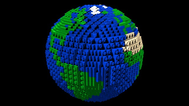
The expressive value of all maps reflect their material media, from printed single-line engravings to digital images. But plastic Lego pieces are rarely considered to have the definition or subtlety of line used in terrestrial map making. The below image seems a poorly pixellated jpeg, but the globe assembled from blocks of tan and blue bits that sits in Legoland, California is in fact a virtuosic assemblage of colored plastic pieces sure to catch your eye. While the globe is yet another display of the artifice of LEGO, there is a sense in which it stands as a p translation of an imperative to map, from how the disposition of continents situated on the globe foreground the exact assembly of LEGO and color choices it offers, it the material presence of the globe it offers in an age when we map the terraqueous surface in grids, and increasingly by layers, nodes, and rasters across national bounds.

For the assembly of LEGO tiles is a material translation of the mechanics of assembling less a picture of the world, than synthesizing datapoints in a new image which acknowledges its own mediations and assembly: the Lego figurines below look at the surface of a paper map somewhat studiously, as if ready to translate it into their own domain. Th citation to map new regions to allow assistance to reach them is a call, after all, to map places in more comprehensive map tiles, and make the “missing maps” that don’t yet exist for so many sectors that may face high needs.

Why assemble a map from Lego that is five feet in diameter? Perhaps the assembly of Lego globes and maps tells us something about our own relationships to mapped space, an area increasingly dependent on design?
The map is not the territory, but the ultimate simulacrum. The interest in fashioning Lego globes is also an indication of how mapping has provided a visual form to challenge new media, and several folks had been tempted to rise to the challenge of create terrestrial from Lego, even before they saw or visited Legoland. Lego aficionado Eric Harshbarger‘s 48 stud “model of the earth from plastic bricks” is based on rings around a north-south axis, which occupied its builder for some twelve hours, who copied an inflated globe made in China; beneath it, Darren Izzard’s more faithful replica of the Legoland structure seems to be kept in his back yard, as a treasured example of his virtuosity and skillfulness in assembling and planning the spherical design of pieces of rectangular form. The globe seems a bit of a jokey masterpiece of translating the three-dimensions of the terrestrial sphere to a two-dimensional surface and back again to a chunky three:


And self-styled “brick artist” Nathan Sawaya took clear pride at his alternative Lego globe, which expanded the two-color globalization e to a broader acknowledgment of topographic variety, extending to maps his demonstrated productivity in his chosen medium of brick art:

But something about the mapped terrestrial sphere makes it a natural subject of Lego as a medium, beyond just a challenge of snapping pieces of the right color together in a spherical body. W. W. Wally almost gushed when he credited Neil Armstrong for the inspiration for his 2012 prototype of three colors, which he based on the method of assembling a Lego sphere that he credited to Bruce Lowell. Is there some convergence between the idea and techniques of globe-making from plastic colored bricks, which Wally boasted he was able to expand to a version using 1500 pieces of plastic by a method he considered copyrighting?
In some sense, the assembly of Lego globes marks a recent resurgence of the DIY craft of globe-making, but also of the ornamentalization or trivialization of the globe as a legible map. Wally made his by employing a Google Earth overlay to design the globe’s surface in multiple colors, sort of projecting the image of the terrestrial sphere in a David Hockney-like technique or an early Chuck Close method, although Wally willingly accepted the constraints that the Lego palette of colors imposed on the completed version—which indeed seems to assemble tiles as so many Lego blocks:
There is something of the trivialization of the pattern of mapped space in all this, or a trivialization of maps as patterns. But there is also an echo of resistance to the dematerialization of maps in the globalized world, where we are more apt to speak of “nodes,” “tiles,” and “polygons” than regard the map as a piece of paper, and in which “maps” less increasingly embody a territorial unit or sense of sovereignty. In a world where the boundaries between nations mean less, and maps are more usefully constructed about wiring or online communities than by geographical proximity, the resurgence of the Lego globe is something like the last site of the map’s retreat or the last stand of the authority of the map as symbol, as well as the demand for new map designs, demonstrated in the huge and almost innate popularity for the use of more artisanal-feeling base-maps, as the palette used Stamen design’s rightly-praised Watercolor style.
For Watercolor restores the role of design to mapping to make it far less datacentrically designed, restoring an absent sense of materiality for which one increasingly longs to the surface of a map; even if its palette betray one stylistic color-changes not reflect the extent of paved land in San Francisco or capriciously introduce phantom green space in San Francisco Bay, it conceals the seams of map tiles in a way that restores the pictorial quality of a web map—
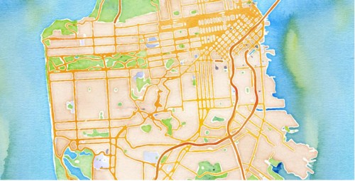
—in ways that reminds us of the romance of materiality of map design we have often lost. In other words, it restores pleasure to map-reading, by reminding our eyes of the materiality of the image of mapped space. It offers a relief to viewers’ eyes that is akin to the entertaining nature of the assembly of LEGO maps, which even if they are not used as guides of way-finding or spatial orientation, affirm a sense of human mastery over space of n the manner of an ancient map. Continue reading

