Tag Archives: human rights

Strongman on the Border

The border was closed and immigration authorities simply ‘at capacity,’ announced newspapers, after a Caravan of migrants from Central America arrived.  In rejecting the ability to process new arrivals who lacked necessary papers of transit, the papers parroted a an anti-immigrant line, revising the southwestern border from a line of passage, or space of transit, in what seemed a meme about the border as a threshold of legality-as if a line defines the legality of those who cross it. 
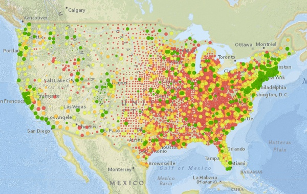
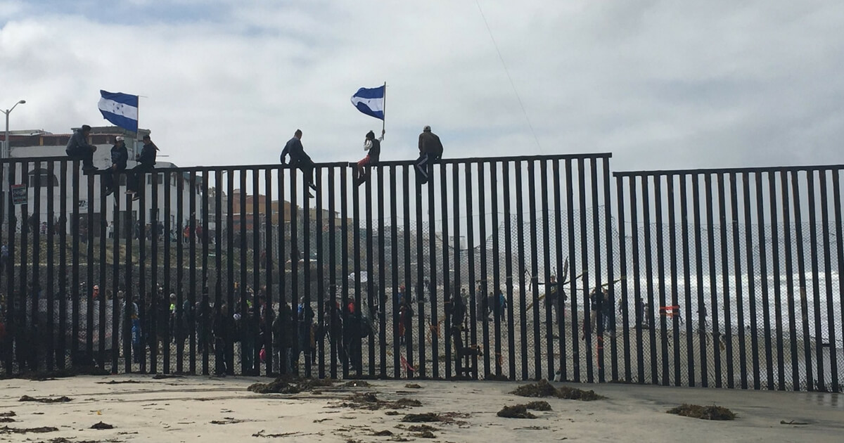
The image that suggested migrants atop the wall, or of others scaling a dilapidated section of slatted border fence near San Isidro–“through a dark, treacherous canyon, notorious for human trafficking and drug smuggling”–collapsed multiple tropes of border-crossing on the least likely of targets:  a peaceful procession through Mexico that began on Easter Sunday, crossing borders to call global attention to migrants’ rights.

_101103435_mexico_caravan_migrants_route_640-nc

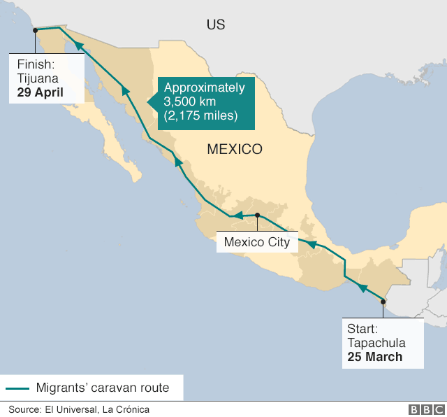
While the simple visualization of the course of the procession that wound through Mexico City from the southernmost border of Mexico cannot trace the mental geography on which the arrival of migrants was mapped in the United States, the progress of Central American migrants was viewed and mapped by Donald Trump and FOX in terms of the desire to see their arrival from behind the proposed $18 billion border wall that has become a contentious object of debate.  As the number of arrests along the border has grown above 50,000 for the third straight month in a row, and more children separated from parents in an attempt to broadcast cautionary warnings about the dangers of attempting to cross the border, or to appeal to existing immigration laws by asylum pleas, stories of migrants that the proposed wall would silence are increasingly difficult to silence or contain, and the human narratives of migrants are increasingly difficult to place behind the imaginary screen of an insurmountable border wall,–which of course does not exist, save as a mental construct–but is cherished as one and difficult for many to relinquish or deny.  
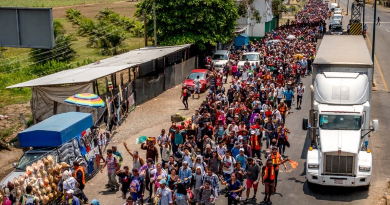
Even though there is no structure corresponding to the height, thickness, and architectural design that Trump had treated audiences during his campaign, the Caravan threatened to remind us that the wall didn’t exist, despite the attention that has been lavished on its proposed construction at a cost of an estimated $18 billion, far below what actual costs might in fact be.

The specter of the arriving migrants from Guatemala, El Salvador and Honduras–the triumvirate of “failing states” that Trump has demonized and sought to distance the nation–seemed cast as an oddly unstoppable “horde” that had defied Mexican immigration authorities who had not turned them back, and whose arrival was magnified as a threat to create a persuasive image that reminded the nation of the urgent need for the wall.  After months of dehumanizing migrants as faceless hordes, poised at the border, migrants seemed to have arrived at the border fencing, about to breach an inadequate barrier that is a relic dating from the era of the Vietnam War.  The news of the progression of the Caravan–and clouded interpretation of what their aims for crossing the United States’ southwestern border truly were–led them to become a poster child for the urgency with which Donald J. Trump has so stridently advocated the construction of a “real wall,” with an intransigence that almost embodies the physicality of an actual concrete wall, a month before the construction of the border wall began in San Diego and Calexico, CA, replacing some fourteen miles of improvised border fencing that was long ago made of scrap metal to “secure our border” as a way to “make America great again.”  The promotion of building the border wall was a way to ensure “public safety” followed repeated images of migrants attempting to scale or protest before existing improvised fencing–

image

-whose inadequacy to deal with the border threat Trump had relentless ridiculed as useless during his Presidential campaign.  The danger of cross-border traffic that Trump had repeatedly magnified circulated back to prominence within the national media with the arrival of the migrant Caravan.  The hope for the migrants to gain asylum in the United States was immediately questioned as their true agenda was assumed to be one of evading the border controls before the Wall was built–and the immigration laws that would permit their entry changed.

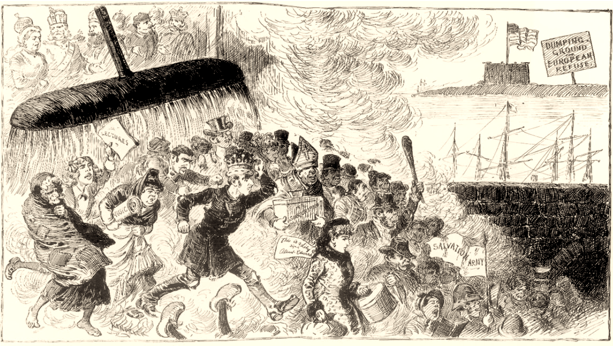
If the announcement of the construction was a feign of a a show of strength, and promoted as a basis for national pride, it was an insult to migrants petitioning for asylum, as the promotion of the border wall as a sign of national security debased the notion of the nation as one of laws and civil society.  The promotion of the wall as a slogan of nationalism remapped the nation in relation to the border, after all, in the Newspeak of social media and twitter–“Strong Borders are Security”, “Immigrants are Criminals”; “Refugees are Terrorists”–the border wall protected national security and projected the idea that all migrants were illegal.  The spatial imaginary of the border wall echoed the longstanding claim, made without evidence, that the immigrants at the border were “the worst” of their society, and for allowing an untold number of undesirables to enter the the nation.  As well as protesting the treatment of the United States”the dumping ground of European Refuse” as an insult to the nation, the insult was accepted by the nation.  The blame rests on citizens who are accept the very immigrants Europe does not want.  The image, which appeared just before Bartholdi’s “Statue of Liberty” was erected in New York Harbor, raised objections to accepting those rejected by Europe’s crowned heads, of dubious value to the nation that echoed Trump’s position.

European Refuse.pngKendrick, “And We Open Our Arms to Them” Life Magazine (July 12, 1885), 

The very chaotic narrative of depositing “human refuse”–a group of former colonials identified as “not like us” but being advanced by an invisible broom–was repeated in the image of the approaching Caravan, as the legitimacy of their requests for asylum from Central American nations were questioned, and suggested to be fundamentally an illustration of disrespect for the law.  The “Caravan” of over 1,000 migrants seeking a better life was widely mapped as a threat to sovereignty and law, recasting a protest march that promoted migrants’ rights as an invasion of sovereign space–and a grounds to deny migrants’ rights.  The  tweets of President Trump directed the attention of the country to the border to query the status of the migrants who were headed to the nation, as he announced instructions  “not to let these large Caravans of people into our country”–magnifying the migrants as a national threat through a dichotomy between “them” and “us.”   The anxieties about immigration policies that Kenrick’s cartoon registered panic at the caricatured faces of the new arrivals.

In announcing an intent of illegal entry across the border, Trump once again conjured the need for a border wall, as if trying to co-opt the message of migrants to create an image of a cross-border threat.  The construction of border walls against an “existential threat to the nation”–as did the former commander of the southern border who was named Trump’s director of Homeland Security and now his Chief of Staff—creates an urgency for protection that corrodes the possibility of an open society.  Kelly’s disparagement of migrants as “people who would not easily assimilate into the United States,” “overwhelmingly rural,” from countries where “fourth, fifth, and sixth grade education are the norm,” described them with the same disdain as Kendrick’s cartoon from the early Life of the 1880s protested the insult by which ex-colonials were sent to the United States as to Australia or India, which had indeed become “dumping grounds” for convicts, remittance men, and socially unwanted cast-offs, as well as seeing them as barbarians who threatening the social fabric of the United States.  The disparagement of migrants who are seeking asylum as uneducated, of rural origins, or indeed, as Kelly’s remarks must have reminded his audience, criminals.

ICE 2014 arrests gangs--ms13?
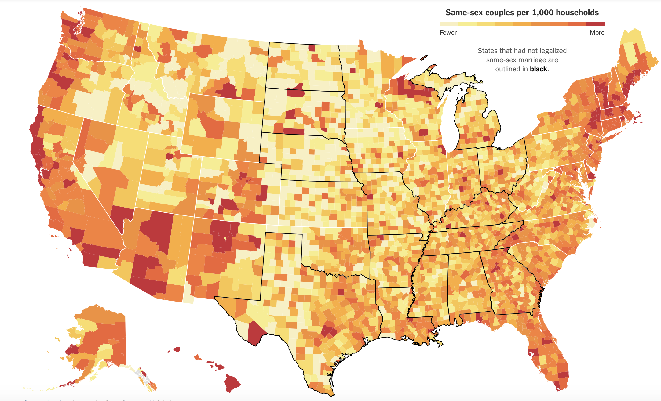
ICE Arrests of undocumented immigrants, 2014

The disproportionate warnings of a “border threat” or “trouble at the border”  telegraphed on Twitter was inserted in a narrative rooted in the plan to create a border barrier of cast concrete in August 2015, in the heat of the Presidential election–a mission that crystallized support behind Trump’s campaign.  Trump insisted that the border wall he advocated wasn’t rhetorical, symbolic, or virtual–a space defined by hi-tech monitoring–but an impervious barrier that would succeed where other poor-quality fencing had failed.

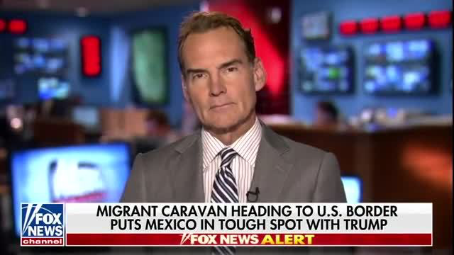
The build-up of the arrival of the migrant caravan ran against the disproportionate attention that Trump had drawn to the border.  As Trump pedaled the fiction that the wall had already been begun, newscasters on FOX mapped a showdown by the approach toward the border of “that scary migrant caravan” of Central Americans with American law enforcement as inevitable, placing the migrants in a narrative of unwieldly crisis of immigration management on the US-Mexico border.  In ways that intersect with a broad unease of increased immigration–often manifesting itself in extreme xenophobia, othering and racism–a vaguely masked anti-immigrant sentiment that has growth in the United States over the last four to five years which Trump has deftly exploited. For the ‘border wall’ was recognized code for a thinly disguised racism, captured in John Kelly’s characterization of the Caravan–and migrants–as “overwhelmingly rural people” not capable of assimilating, who “don’t have the [necessary] skills” to do so, and are “overwhelmingly rural people,” as if ignoring just how dependent U.S. farms are on immigrant labor.

The disproportionate attention the Trump and his planned border wall directed to the southwestern border made the region seem far more immediate to all Americans–and defined the Caravan’s approach as national news.  Although the formation of such “Caravans”–a name not coined by Americans, though it gained new spin in the mouth of President Donald J. Trump, who had grown frustrated with an uptick in U.S. Border Patrol metrics of illegal entry–the tactic that was long adopted by advocacy groups to foreground migration difficulties was used by the group Pueblos sin Fronteras, or Peoples without Borders, whose name was seen as revealing their opposition to the redefinition of the southwestern border of the United States, which has also been mapped onto the wall–creating a reflexive panic at the sight of large crowds of unidentified migrants marching toward the border.  The legal and physical obstacles that Trump promised to place on Mexicans or Central Americans seeking entry to the United States were always twinned, but the arrival of the migrant Caravan seemed to give it a new urgency, and to legitimize, as a suddenly mainstream demand of border management, the ability to control human cross-border flows.

image.png

The march was described disdainfully as a “political stunt” in media, as the Attorney General and Director of Homeland Security demonized the “Caravan of migrants.”  Trump had promised the nation a border wall unlike the reclaimed corrugated metal fencing in Tijuana, but made of  “precast [concrete] plank,” a protective barrier far more powerful and robust than the inadequate fencing he treated as “a joke” and a disgrace to the nation, and which the multitude of migrants were seen as able to cross, but in need of immediate arrest and detention in a fantasy of border enforcement.  If Trump had promised to be a strongman at the border, the old border wall seemed indeed flimsy obstacles, unable to stop even the crowd from the Caravan who arrived to petition for asylum at San Ysidro, CA.

Migrants arrive at Tijuana

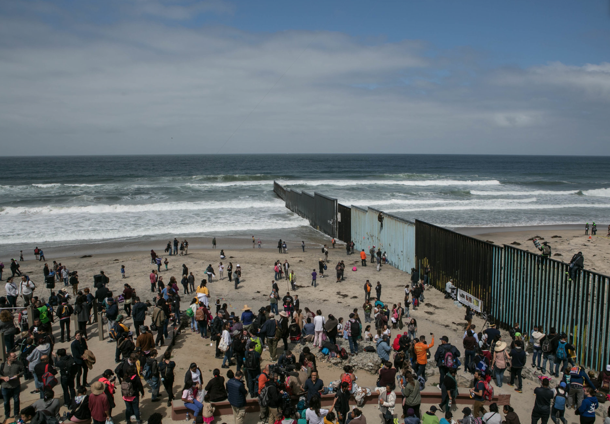
The peaceful protest of the Caravan de madres centroamericanas, to use their full name, was recast as a march of opposition to Trump’s border policy, while for Trump, as some three hundred odd members of the Caravan arrived at San Isidro, a recognized port of entry, in five busloads, and mounted on a fence made of repurposed scrap metal became for President Trump evidence of a crisis of sovereignty.  In response to a crisis he seemed to have created on Twitter, he ordered the Department of Homeland Security to “stop the caravan,” displaying his knack for sound bytes and slogans, and imagine that, searching for the right string of capital letters on his keyboard,  only “a strong, impenetrable WALL. . . will end this problem once and for all”–even if the problem lay with the places the migrants had fled.  The motion of “migrants,” now cast as “illegal aliens” in the right-wing press, even as they hoped for a miracle from god able to “touch the hearts of immigration agents,” was not able to be seen clearly by many, even if their course was carefully mapped over the previous month in increasingly colorful reportage.

image.png

Continue reading

Leave a comment

Filed under 2016 US Presidential Election, Donald Trump, immigration, mapping the US-Mexican border, undocumented migrants

Targeting Sites of Attack in Syria


Syria, for now, remains on the map.  But in the course of over two years civil war aged across Syria, the government of Bashar al-Assad has stock-piled chemical weapons as a last line of security in multiple sites.   President Barack Obama’s administration has made use of chemical weapons against Syria’s population a justification for military attacks against or intervention in the country.  But the prominence given to drawing this “red line” on the use of such weapons neglects to assess the pragmatic results of any intervention, and the nature of what form on-the-ground intervention in the relatively shifting state would take–or what ends such military actions would be able to serve.

The direction of the situation is not good, to be sure. The number of Syrians reported killed, abducted, gassed, or poisoned during the civil war over the past two and a half years, tabulated by Syriatracker, clearly centers the focus of violence around its capital city, Damascus, and is probably vastly under-reported:


Syria Tracker- Missing, Killed, Arrested

The on-the ground situation is more complex than this map of reported violence:  especially if one looks at the disparate groups that have independently continued (or sustained) the ongoing rebellion against the Syrian government, or, even more strikingly, at the huge number of internally displaced Syrians, a number greater than anywhere else in the world; and the  number of Internally Displaced People is difficult to count; estimates are 4.25 million–almost 1 in 5 Syrians.  The consequences of this displacement are impossible to map.


The situation on the ground has provoked this displacement through the fragmenting of the Rebellion into multiple fronts.    An important and informative interactive Al Jazeera map of groups in the Syrian rebellion provides a far more complex measure of divisions among rebellious groups that have attracted different financial and military backing to overthrow Assad also challenging to map:  rebels on different fronts include the large Northern Front near Damascus to Aleppo Front, Idlib Front, and Eastern Front, some in uneasy relations to one another, and is worth examining in depth at its website, in order to understand the mosaic of divisions in a landscape whose sectors are often pointlessly divided between “rebel-held” and those where Assad is dominant:

Mapping Interactive Map of Syrian Opposition
Al Jazeera English

The above image of the fragmented nature of local control, and the independence of each group from one another, suggests the difficulty of defining a clear point of entrance and reveals the nature of ‘proxy war’ that has expanded over two years since the Arab spring, as the response to the Arab Spring of April 2011 that challenged the Assad dictatorship were almost randomly attacked by a violent militaristic security forces that echoed the violent tactics of Bashar’s father, firing live bullets into crowds of protestors and unarmed civilians, killing many innocent children, in acts of carnage and terror documented by Human Rights Watch as killing 587 civilians and over 250 children that emulated the theatrical mass-assassinations orchestrated against Syrians by his father, Haifez al-Assad.  The repressive violence of these events, before civil war, increased the range of foreign bankrolling independent factions of rebellion, which is misleadingly cast as uniform by a map of anti-government forces as the below two-color map devised for Max Fisher of the Washington Post, which borders on intentional political disinformation:

syriaForMax-2


Despite using a uniform color to denote “rebel presence” as a single, uniform beige to mask divisions within “rebel presence” and the numerous individual deals that the Assad regime might make within them–and mask the actual of what David Brooks and others correctly identify as a “proxy war” between Russian planes flying from Iran over the nation, Hezbollah present in Syria, and with multiple “combustion point for further waves of violence.”   The war is, in fact, not properly “civil” at all, so much as a broader war for the realignment of Middle East politics–and despite the attempts of previous administrations to involve rebel groups within the negotiation, the readiness with which the Trump administration seems more ready to strike–or threaten to strike?–from the eastern Mediterranean, Persian Gulf, and Red Sea–with less attention to the ethnic composition of Syria, than its own show of strength.


image.png


We have been particularly ill-served to understand the nature of this “proxy war” by the reductionist attempt to map ethnic diversities in Syria as if they revealed an internal fragmentation of a nation that is being driven apart by exterior forces.  Such a map implies that the many sectarian divisions masked by the creation of the Syria’s borders account for instabilities among rebel groups, as if they are inherent in a multi-ethnic state as an amalgam of faiths destined to implode, regardless of the brutality of the two generations of the Assad regime:

Levant_Ethnicity_lg-smaller1-zoom

Yet the divided nature of the country lies in part in the improvised nature of resistance to a totalitarian regime, and the culture of violence that has been normalized within the Assad regime and within Assad’s security forces–the notorious Air Force Intelligence (إدارة المخابرات الجوية‎), whose ties to chemical weaponry have been substantiated in the recent past.

The drawing of stark divisions between areas controlled by different fronts and subject to government control obscure the near impossibility of drawing these lines of distinction along clear territorial boundary lines–and prepare a deceptively simple image of Syria’s future.  One BBC news-map helpfully re-dimensions the local conflict, mapping government positions toward the coast and eastern cities, around holdouts and temporary redoubts of rebel resistance–although clear mapping of their division is difficult given the shifting landscape of alliances and lines of territorial defence among highly mobile guerrilla forces, who often tactically withdraw, rather than face military engagement, but can’t map the shifting lines of opposition or control–or the relations between the fronts that are themselves supported by different constituencies in a patchwork of strongholds:

Mapping Syrian Conflict BBCBBC/Syria Needs Analysis Project


The map poses deep questions of what intervention would mean without a clear map even available to be read.  They also reveal how much the debate about war is being waged not only in words, but maps.  The focus of global attention is not only on the violence that has divided the country for over two years, to be sure, or the humanitarian disasters created by the many refugee camps on Syria’s borders, but allegations of the use of chemical weapons.  Yet the mapping of Syria’s disasters and composition are central to any discussion of military intervention.

And we now have a map of where strikes might be directed against air force bases and sites of chemical production, courtesy Foreign Policy magazine, which uses a Google Maps template to mark the storehouses of potential chemical factories and air bases targeted as primary sites of missile attack:

Air Bases and Chemical Sites in Syria


What sort of a vision of Syria as a country does it describe?  The visually striking deployment of skulls-and-crossbones icons to designate locations of plants that produce chemical weapons is scary, and so much so that it almost evokes incursions by pirates along the Mediterranean coast–as much as sites of chemical weapons.  (Of course, such sites would not in themselves be targeted, but the decision to avoid them depends on the accuracy of military intelligence; the decision to target all pharmaceutical factories also poses a  future crisis for already over-crowded Syrian hospitals.)  But it suggests a rather blunt map of the notion of military intervention, and reveals the difficulty of projecting a limited surgical strike against selective sites that are removed from the Syrian population.

In the light of the relative military success of the long-distance bombing strikes into Algeria, it seems tempting and morally compelling option to end the violence and self-evident terror of gas attacks by unseating the Assad tyranny, or by providing Syria with a clear warning–although what it would warn we are not sure–against purposefully deploying chemical agents against its citizens.

The map raises many questions by marking so many facilities along Syria’s Mediterranean coast.  It makes one wonder how such a map became so easy to reconstruct–and the wisdom of allowing such a plan of attack to be rendered public on the internet.  For the map suggests that strikes can be easily launched, in a sort of war conducted from aircraft carriers at a distance against Iran’s close ally, firing Tomahawk cruise missiles at them from American warships moved to the eastern Mediterranean–although it’s relatively easy construction has led many to openly wonder why such a detailed range of options would be publicly leaked by the White House in such detail, even indicating the targets of a strike of one to two days against fifty specific sites.  (Reuters found redeployment of many key army, air force, and security headquarters buildings in central Damascus that might attract U.S. cruise missiles, and poison storehouses, if not sites of production, could be moved.)  Would it be worth the potential danger of hitting a storehouse of sarin or FX?

Targeting chemical factories, moreover, does not address the likely existence of available chemical arms–although attacks render their release more likely. Every chemical plant is not the producer of sarin and mustard gas.  In imagining the raids on the air-bases and potential sites of chemical weapons, the map takes advantage of a registry compiled by the  Nuclear Threat Initiative locating where weapons are either manufactured or stored.  Yet despite the offensiveness of chemical gasses, their repellent nature, and their close historical association with threats or attacks of terrorism, what sort of counter-attack on the Syrian population the government would unleash as a response to the attack is not clear.  The attempt to paralyze Syrian aircraft who might attempt to deliver them seems worthy, but the bombing of potential plants risky at best. Bombing sites of chemical production doesn’t sound like that great an idea after all, however, since this would most likely disperse the very gasses that they contain–with more dangerous effects than the uses of Sarin or FX against the Syrian population–if such targeting would of course not be intentional.

The incommensurable relation between an air-raid or selective missile strike with storage-sites of chemical weapons has led several to question the value of such attacks, even after knowledge that the government may have intentionally used poison gas against its own citizens.  There is a small likelihood of eradicating more than a small portion of stockpiled chemical weapons in the country, since, unlike biological weapons, most probably will only be widely dispersed by such a blast–and conceivably hurt civilians as they more widely and rapidly disperse, considerably raising the bar for “collateral damage.”

How any such sort of attack will change “action on the ground”–and the questions of what military strike can alter the humanitarian and moral disaster that Syria has already become–remind us of the pressing need to have a clearer map of the action on the ground than a Google Map can reveal, as we examine consequences of a “limited air strike” beyond the hope to cripple the Syrian airforce or discourage the terrifying possibility of further use of poisonous gas against an opposition–and ask if a “limited air strike” is possible in this complex geopolitical microclimate.

Lastly, the mapping of clear targets and divisions within Syria’s boundaries obscures a hidden–but important–map of refugees on the borders of the country.  As well as having internally displaced millions, the fragmentation of fronts in the country have created a growing humanitarian crisis in camps on Syria’s borders, and the 3.5 million refugees who are estimated to leave the country by the end of 2013 for neighboring regions, further fragmenting and dispersing the country’s population:


map refugees Syria by 2013 3.5 mill


Color-coded according to the largest number of Syrian refugees received in each country, we range from deep purple in Lebanon (more than half a million refugees dwell), and just less than half a million are in Jordan and Turkey, and smaller numbers in Iraq and Egypt  – 161,879 and 75,456.  This alternative geopolitical map serves as a negative view of the strategic relations between he nations.  It also poses a problem of how each of these countries respond to the crisis:  such a data-visualization fails to render the different immediate challenges of each refugee family, their poverty, and their amassing on the borders of each region, rather than throughout the country.  For this is a humanitarian disaster waiting to be mapped.

Given the difficulty in mapping the multiple divisions within the country into rebel and government forces, and the crises of internal and external displacement of Syria’s population, we must resist seeing mapping clear targets of attack.  The maps of clear divisions in the country as a clear opposition of forces are distorting filters that are more distracting than they are informative, with overly neat and tidy boundary lines.  The complex conflicting rebel factions supported by backers, and the sort of power vacuum that would be created by significant and serious destablization of the country or desperate responses (or the shifting of responsibility) that strikes against the country’s remaining inhabitants might trigger.

Syria’s conflict of course exists not only as a map of frontiers and inhabitants.  Worldwide, it should be remembered, there remains significant opposition to military intervention, charted by Mona Chalabi and Charlotte Henry in the The Guardian’s datablog–not only because of longstanding alliances between Iran and Syria, or Syria and Russia, but exceedingly complex questions of what ends intervention would accomplish–and what outcomes it would produce, as well as how it would be sustained.


Condemnation of Intervention


Viewing the conflict in Syria not only through the lenses of national alliances, but by what can be best mapped on the ground, must become more central to US foreign policy objectives.  We cannot “chastise” or “wound” the Assad regime without realizing that we may wound the country, or erase it from the map.

All too easily, from the point of the United States, at least, we risk viewing the conflict either too much on the micro level, or at a remove of the capacity of bomb strikes, paying far less attention to the delicate nature of the situation on the ground.  Indeed, the faux apocalyptic tenor of some maps of imminent war that is tragically advanced by right-wing bloggers, that strip the power of cruise missile strikes from their context–


image


–suggests a removed image of the ability to launch air strikes against a nation at a remove from the ground, and an ability to “target” strikes–the illusion of GPS–at a single dot, without registering the huge impact such strikes would have on a country and is inhabitants.  In an era of shooting first and asking questions later, by 2017 we use maps to fire from the hundred and five missiles on Assad’s “chemical weapons facilities” as “surgical strikes” by tools able to pinpoint chemical weapons storage and research facilities outside Syrian cities, as if they have a fixed non-human target to eliminate.


APTOPIX_Syria_US_88463-cf2b5
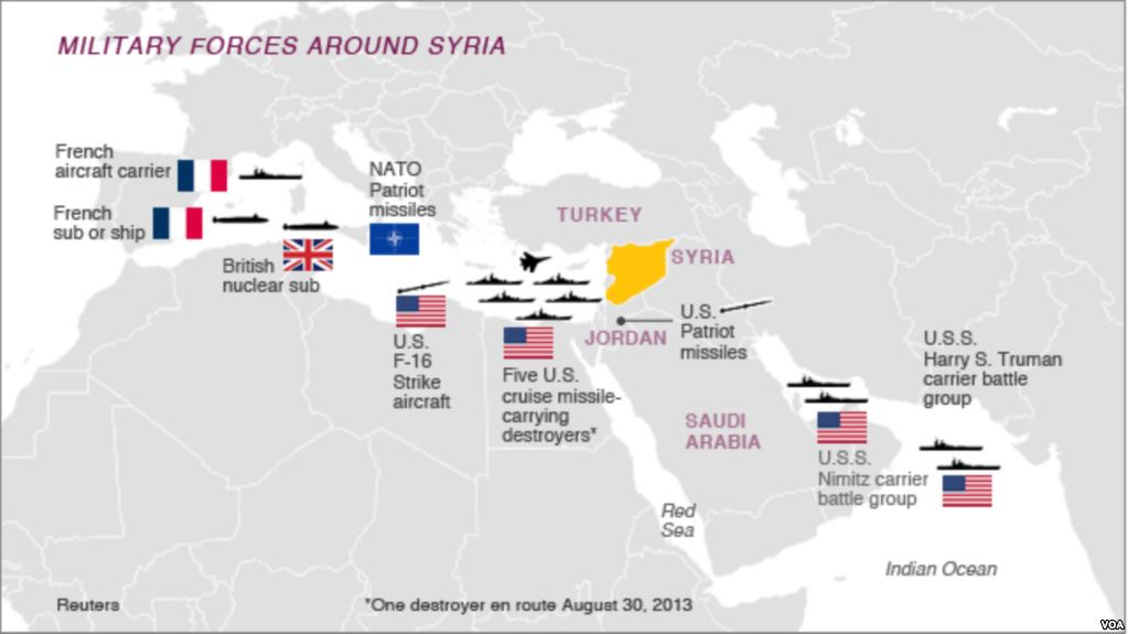
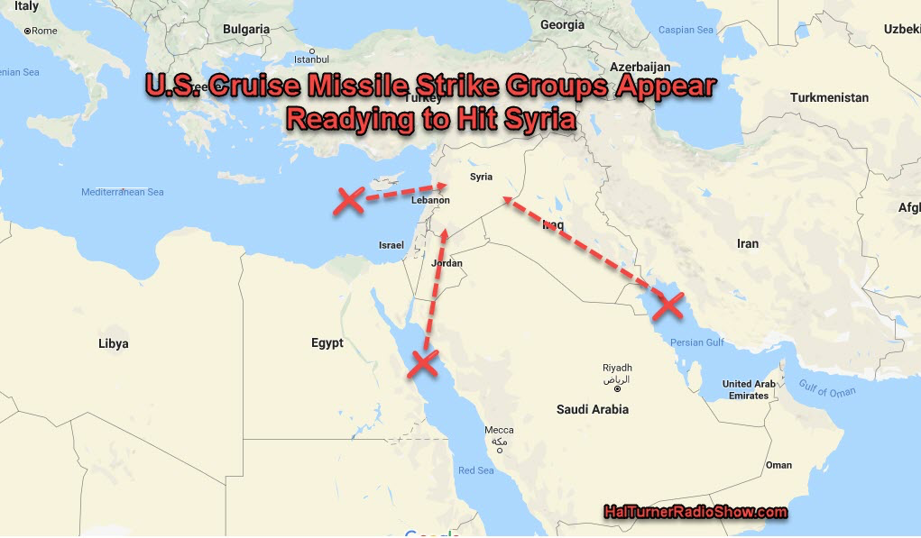
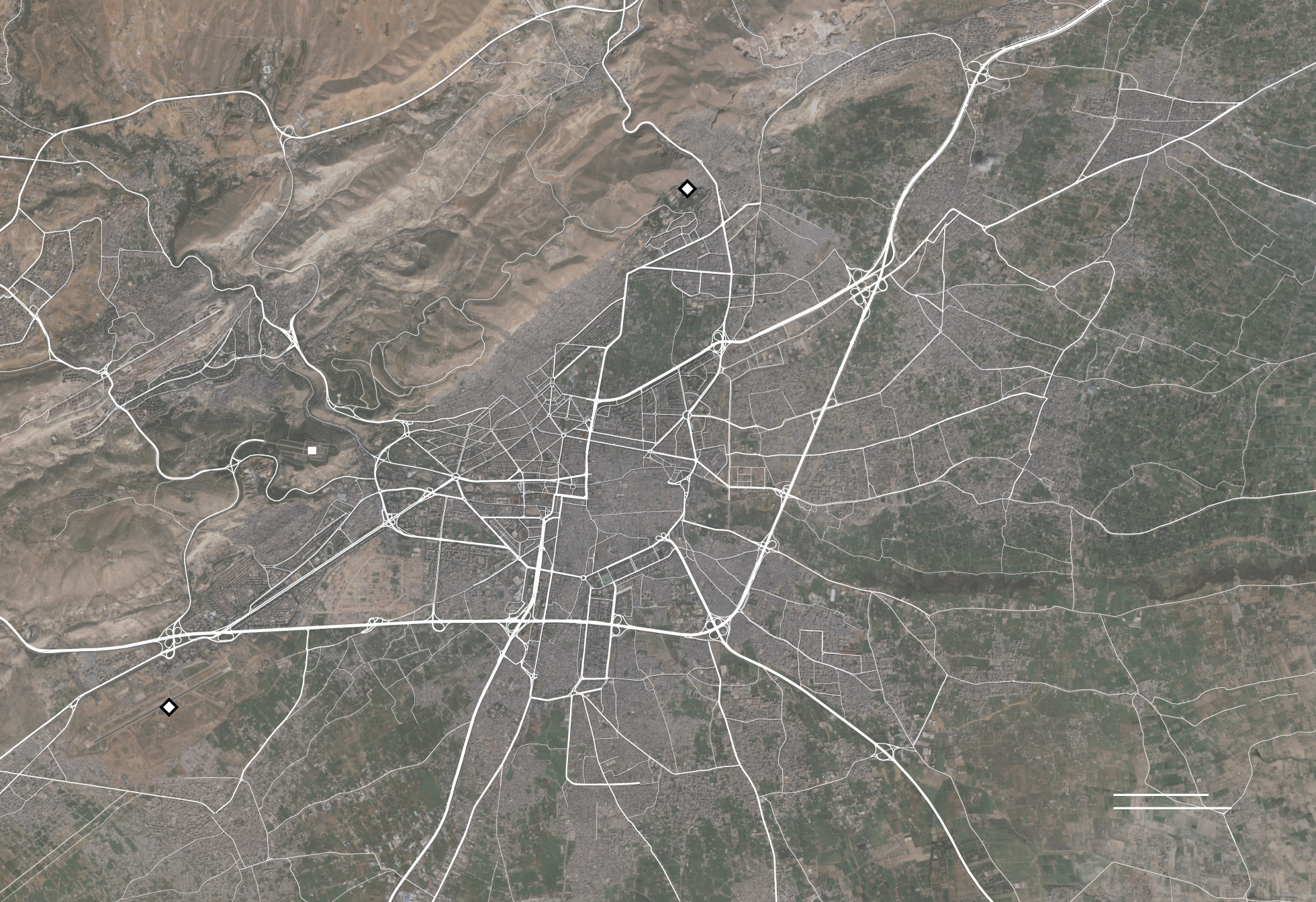
Targeting of Syrian Capital on April 14, 2018/Hassan Ammar/API


Can the promise of mapping with such precision inflate a sense of the ability to intervene from a remove, targeting targets outside Damascus as the Barzah Research and Development Center, or the Him Shinshar complex outside Homs, without terrorizing the Presidential Palace, and without worrying that such armed interventions will not eventually escalate, as they dramatically change the experience on the ground?


image.png

8 Comments

Filed under Mapping Chemical Weapons, mapping ethnic groups, newsmaps, Syrian Civil War

Mapping Reactions to Marriage Equity and Equality, at Home and in the World

The radical transformation over just ten years in the status of marriage equality in the United States–progressing from the first prohibition of rights to same-sex marriage and first licenses issued in the state of Massachusetts to the recognition of same-sex marriage nationwide–has “made our union a little more perfect” in 2015 no uncertain terms, as President Obama perceptively observed recognizing the recent decision of the U.S. Supreme Court.   The verdict has also brought us into line with recognition of a social order, and forcefully recognized marriage as a human right.

The ground seems to have changed beneath our feet.  In recent times, the United States was of course a relative outlier in the recognition of the sanctity and legality of same-sex marriage: both just two years ago, and indeed during the ten years when the issuance of same-sex marriage licenses first began.  Although there is continued reference to “insider” sorts of knowledge that may inform pronouncement and recognition by Justice Anthony Kennedy that “It would misunderstand these men and women to say they disrespect the idea of marriage,” and unconstitutional to deny a right permitted by the U.S. Constitution, the apparent rapid change in state policies of recognizing marriage equity-and sanctioning same-sex marriage licenses–did not only have its origins in the retrograde retrenchment of the “Defense of Marriage Act”–a piece of legal attempt to prevent the acceptance of same-sex marriage enacted in Utah twenty years ago back in 1995, which has however been subsequently overturned.

1.  A broader global map contrasting the criminalization of same-sex marriage against its sanctioning reveals that rather than about red- and blue- states, or even political affiliation, debates on marriage equity are actually about human rights and dignity–in the face of which state statutes restricting marriage were disputes about legal definitions of matrimony–and demanded that an accumulation of scores of local legal precedents struck them down.  For dismissing “traditional marriage laws” as both legally retrograde–see below–and of painful personal consequences, and the acknowledgment of civil and natural rights.

Mapping the Legality of Marriage to Death PenaltyMax Fisher/Washington Post

The ancient geographic concept of ecumene described the world inhabited by men–excluding torrid zones that did not permit life, and based the concept that one could circumscribe the limits of its inhabitability.  One could just as easily trace the world inhabited by gay marriage today, noting, however, not actual atmospheric variations in climate or temperature as the prime indices of livability, but mapping the distribution of legally recognized same-sex unions.

Despite the current evidence of ties between maps and surveillance, the maps visualization of the legal permissibility of gay marriage suggests a deep distortion on the appearance that the world’s surface is by and large inhabitable for all–red dots indicating place where gay unions are penalized, in this visualization created by OpenStreetMap contributors in Tableaux.

matrimonio legalizado

While a global visualization of different legal standards reveals that this is by no means a local issue, it does suggest the outlier status of the United States on a question of civil rights, already resolved in the jurisprudential thought as well as social practice in much of western Europe, Canada, Argentina, and Brazil, as well as South Africa.

2.   Such world maps offer valuable context for interpreting the recent reversal DOMA faced within the United States, and Justice Kennedy’s majority opinion on the constitutionality of same-sex marriage.  For they help us better map ourselves in a global context:  we seem more than a bit retardaire in our legal codes in the Anglophone tradition, if you didn’t notice, and perhaps the least cosmopolitan of all:  the 49th parallel cuts a pretty sharp line across North America for gay unions, and a deep break between the US and much of Central America.  (Let’s bet this wasn’t on the short-list of Obama’s conversations with his African allies–at least until he reaches South Africa, a rare case of the legality of gay marriage in that continent.)

Despite a huge change over the markedly a dramatic seachange in the legal definition of past fifty years across individual states of the union, the national policy about marriage inequality in our fragile union seems to make the United States something of an outlier across much of the world’s populations–and most especially in regards to most of its traditional allies.  Before the Supreme Court confirmed the right of marriage for all, the court moved to reject the a huge quantity of local legislation enacted at the state level in striking down the DOMA and Proposition 8 in June 2013.  The court’s decision explicitly reacted to and rejected the decisive progress in LGBT legislation recently charted in 50 Years of Changewhich was recognized by winning an award for the most successful dynamic narrative map.  Its attempting to map and measure local acceptance of marriage, civil unions and domestic partnerships across a starkly divided nation, and indeed the changed tapestry of the nation, ended up describing the changed landscape of marriage equality in recent years across our national union, in ways that effectively worked to map a salient cultural and sociological change over space.  For such a map is a description of a mutation of legal opinion over space, as much as it charts a broad cultural change or a shifting consensus about public speech.

3.  A map devised by Rashauna Mead, Erin Hamilton and Vanessa Wetzel from the University of Wisconsin, Madison, and tells a dramatic parallel political narratives of both the dramatic expanding limits for marriage equity and an intensified polarization among those states denying or legislatively banning civil unions (shaded orange or dark orange) and legal recognition of domestic partnerships, civil union or same-sex marriage (light blue; dark blue; black).  The 2013 map was awarded the NACIS prize for narrative map, and provides an illuminating narrative of legislative change that was so fundamental to Kennedy’s decision.  The piecemeal progression of individual changes toward legal recognition of cohabitation and marriage equality, if a very minority movement until the 1990s, have come to divide the nation within the last five years along increasingly stark lines:

1963 civil rights

1980 civil unions

1997 gay unions

civil unions 2010

Cibil RIghts Marriage Equality 2013

Maps created by: Erin HamiltonRashauna Mead, and Vanessa Knoppke-Wetzel, from Fifty Years of Change

Of course, the divisions defined by such chromatic contrasts are now relics of a past patchwork of legal customs that was primarily defined by local statutes, but which clear pronouncement of equity had to occur to change the map to one hue.

Same Sex Marriage 2015

The increased divisions over an issue that had hardly entered the national legal debate during much of the era of expanding civil rights had at first polarize the nation, but almost inevitably receded into the past as the strength of resistance to marriage equity was struck down.  Put in perspective by this animated info graphic, Fifty Years of Change, the difficulty of crafting consensus on a polarizing issue is apparent, particularly in an era of increased recognition of states’ rights when the assertion of anything like a national standard–even as a matter of human rights–threatens to smack of federal intervention for several of the current Supremes.

Justice Kennedy’s sentiment that human dignity must be respected in a global context, one could argue, even if the United States lags far behind our NATO allies in accepting LGBT civil rights.  Kennedy’s recent forceful (and more compelling) formulation that marriage is a right of self-fulfillment that “embodies the highest ideals of love, fidelity, devotion, sacrifice, and family” is a conservative notion of marriage–but the impassioned defense of equal rights to a union that “embodies a love that may endure even past death” enshrines the notion of equal rights in a powerfully forceful manner.  It essentially emphasizes the injustice of denying the possibility of its fulfillment and their full participation in society. The construal of the right to a marital union and the inability to preserve exclusion from marriage as an institution and ensure “equal dignity in the eyes of the law” reflects less a change in attitudes, but strictest rpreservation of individual rights.

It is striking that the debate about such social and institutional acceptance have become so clearly divided in different geographic locations, even as the world is increasingly globalized.  The widely differing responses that were provoked by the question “Should [your] society accept homosexuality?” showed French and Canadians only mildly supportive of legal recognition of same-sex sacraments, and even less positive response elsewhere, including Brazil, despite strong support in Spain and Germany, and similarly lukewarm support in Japan.  The provocative nature of marriage inequality may put us just barely ahead of the median, if far behind the cutting edge of judicial recognition of individual rights.  But it would be, one senses, for Justice Kennedy, an unwarranted position to deny that right or legally exclude anyone from its obligations and duties.

gay-tolerance-map_630

It is incumbent to try to imagine a future map of areas that hold same-sex marriage an inalienable human right.

4.  The question of social attitudes toward marriage, while often mapped, are not prominent in Kennedy’s stirring opinion.

Despite the uniform blocks used in the above maps, actual maps would require greater granularity of a complex issue–and an attempt to map the variations on the ground in different states’ populations has been increasingly attempted in recent years, as a change in attitudes has seemed to become increasingly diffused both in media and in public debate to a degree unprecedented twenty years ago.  In 2012, City Lab in The Atlantic created a static detailed palimpsest of a map fascinating in its progressive shading and detail of tracing competing attitudes to marriage equality, so rich with variations that it was taken up by Democratic Underground, and particularly popular because it punctured the notion that there was a dominant tendency to reject the social acceptance of marriage of gay couples in the United States–and seems to have registered a tipping point, suggesting as it does a shift in the probability of an eventual common social consensus about same-sex marriage, rather than a deep or irreversible social divide that had long been retained–perhaps reified in a perverse way by recent national elections–as a stubborn spatial imaginary of the limited social consensus about the universality of marriage rights across the United States.

The map, extrapolating from data in create an Esri tapestry segmentation to parse gradations of social acceptance of marriage equality.  Charting differences in intensity by green and yellow, and the strength of opposition in orange and red, the map of public opinions reveals a true tapestry of social attitudes across geographical divides, showing consensus across many states, and even marking far more consensus than ambivalence:

Esri Tapestry--Gay marriage support

City Lab (2012)

There is a bit of a lack of consensus, to say the least, yet a very deep density of apparent unease at gay marriage in specific swaths. The big news of giving greater local detail to these complex negotiations of our notions of marriage suggest the traditional coastal rapprochement in a political spectrum, but a broad shift in the most densely populated areas of the nation. But strict opposition to marriage equality seems too clearly stand in the minority–even in the electoral map–in ways that suggested the possibility of moving toward a more perfect union.   Of course, the question of public opinion is distinct from the question of law, but the accumulation of legal precedents that the granting of broad acceptance of same-sex marriage as a right brought opened a broad window for relatively rapid change.

Such a map of attitudes must be placed beside the changing geography of where spouses of the same sex reside.  Although the legal equality of a right to marriage was not couched in terms of a cultural change by its framers, the spectrum of attitudes revealed in the recent analysis based on county-by-county estimates using the 2010 Census that provides the basis for the map by Gary Gates at U.C.L.A. of where same-sex spouses live.  If undeniably a function of local jurisprudence, it clearly reveals considerable concentrations of such marriages even in areas where same-sex marriage was not itself legalized as well as suggesting a steep opposition of acceptance to same-sex coupling that suggest the long-term struggle the country will face.

Where Same-Sex Couples Live

2010 Census County-level estimates mapped by Gary Gates, Williams Institute (U.C.L.A.)

For all the mosaic of attitudes revealed in the City Lab map of 2012, in other words, that less precise map must be read side by side the contrasts that future Censuses will reveal.  However, the question of individual preferences–and reported data on household status–is not a predictor of legislative change.  By 2014, the accumulation of a range of local precedents and statutes that recognized the validity of marriage as a right attainable by any two individuals of either sex had been effectively recognized throughout the country, making it difficult to deny the right as an individual decision tied to the security of a family, home, and rights to insurance, inheritance or wages:  if a bifurcation existed in local statute legislation across the country, that has some interesting correlations to the above survey of opinions, if it also reveals a deep disconnect between the official policies of many states and their residents–including parts of Michigan and North and South Dakota, and indeed much of Texas.

2014 bifurcation

5.  The rapidity of this historical change is incredible, because it has been so rapid, and, in a sense, so much of a relief for much of the country. Although there exist few clear historical pointers able to be identified for such a widespread legislative embrace of the right to marriage, even if it’s acceptance have been long seen as akin to the racial hatred that are rooted in an even more explicitly odious practices of oppression, the overcoming of oppression seems undeniably healthy in creating a more perfect union in the nation.

For the acceptance of marriage as a right has become undeniable, and the differences in acceptance–if few were able to allow it earlier–decayed in the face of an attempt to deny marriage to all.

Leave a comment

Filed under civil rights, marriage equality, same-sex marriage