Tag Archives: oil speculation

Very Perilous Waters?

Urgent hopes to discover the five passengers tragically killed in the lost submersible off the shores of Newfoundland spread with compelling urgency across global media after the Titan Submersible lost contact with those on land. The disappearance of the crudely-designed submersible that Stockton Rush had claimed would offer a voyage to the ruins of the great tragedy of the twentieth century had exploded from the undersea pressure it endured as it descended to the wreck of the Titanic. The voyage had tempted fate as a disaster in the making. fell off of the global map, venturing deep, deep underseas. The craft’s tragic disappearance quickly dominated global media with an odd urgency of portentousness fed by the image of a renegade entrepreneur who seemed, despite his worldly wealth, to be courting disaster, in braving a new frontier of an improbably untouched wilderness. Although no bodies or skeletons remain on the Titanic’s undersea ruins, the loss of life that was itself transformed by newspapers into a traumatic site of global mourning and tragedy was eerily replicated. What Rush and his company, OceanGate, had promoted as an ability to transcend a classic icon of death, or at least carry paying observers to see at first hand, was a project he pushed even while making the deep diving sub out of experimental materials, without any third-party oversight, out of the robustt sounding materials as carbon fibre and titanium.

The wreck of the Titanic is an icon of unbearable loss, the scale of whose unexpected destruction is an icon of loss that continues to attract curiosity as it still fails comprehension for many as an epic tragedy. The promise to revisit the unspeakable pain of ruins long lying on the ocean’s floor was perhaps a form of triumphal return. It had been promised to a once-in-a-lifetime underwater voyage, by new technologies, if one with origins in the early twentieth century diving bell. For Rush’s small pod-like vessel several feet in diameter was fitted out as if inversely to a stratospheric balloon, promising take one to depths at which no humans had traveled, as if to a new frontier of utter darkness, removed from terrestrial light. But the hubris of visiting the technological disaster of the Titanic–a primal scene of the mid-twentieth century, which Rush now promoted as a disaster tourism with more than a bit of Jules Verne in it, to the confines of the known, equipped, with the self-assurance that spurred his confidence to try to push limits. Rush had assured his coworkers and subordinates that he would undergo a safety assessment of the craft–he was aboard it, after all, and claimed in board meetings about safety concerns had proclaimed “I have no desire to die,” arguing the deeps dive was “one of the safest things I will ever do,” that suggests a deep self-deception terrific in its determination to escape outside oversight. As much as the name of the Titanic promised to face the “titanic features of the wild” in the manner of the American naturalist Thoreau argued met our “needs to witness our own limits transgressed,” every schoolboy’s dream, and Rush seemed so convinced “I understand this kind of risk.” Yet although the vessel he piloted had made the trip down to the deep-sea ruins some thirteen times before, the degraded state of the hull caused it to implode suddenly at 3,000 feet depth suggested “sustained efforts to misrepresent the Titan as indestructible” animated Rush, driven not only to explore the deep sea ruins, but resist registering the craft to any nation to erase regulatory oversight: the dive in international waters evaded all governmental oversight, suggesting the fault lay not only in a “bad actor” possessed by delusions, but abilities to elude government agencies in a hot market for deep-sea exploration.

Indeed, the picture provided by a whistleblower who was far more trained in underseas missions suggest that the degraded nature of the hull that was not only exposed to deepsea pressures, but to face the winter conditions that could have compromised the composite hull, was prominent tin the number of safety concerns many felt in the submersible community, but which Rush tried to shirk off. While not diabolic or nefarious, a desire to achieve not only the insurmountable dangers of deep-sea exploration, or to “touch death” by visiting the deepsea ruins of the Titanic at first hand were animating Rush’s apparent obliviousness to oversight, and intense silencing of executives and employees to raise concern about the absence of inspectors but insistence to dive to unprecedented depths for financial gain led Rush to silence the experts that he employed, and retain the “experts” h needed for window-dressing to add public luster (rather than real oversight) to the mission.

Over the four days of panic that rescue forces and underseas divers searched to map traces or survivors of the imploded submersible, hoping that the children at least might be living, somehow, trapped in safety compartments beneath the sea, as we wondered how legal parameters on deepsea travel were avoided, we rarely heard from or about whistle-blowers who had long raised questions bout Musk’s overeager plans, trying to alert the very workplace safety regulators–OSHA; –that Donald Trump is, with eager encouragement from the business world–trying to limit and erode. For OceanGate’s quite sturdy Director of Marine Operations, sea-going Glaswegian David Lochbridge, who had worked with a range of submersibles for the Royal Navy and then as a pilot of submersibles in the North Sea, was shut out of the launch of the Titan: he was indeed silenced, and forced to watch the arrival of the titanium caps on the ends of the lost submersible as they returned to shore with everyone else. or if Lochbridge had promptly alerted to the design dangers of the tiny submersible oddly named the Titan,-as if it were the lesser cousin destined to meet the Titanic. The underseas engineer wrote promptly to the Occupational Safety and Health Administration–OSHA–in the United States, who themselves had alerted the U.S. Coast Guard. Yet OceanGate lawyers were set like attack dogs: they insisted that he pay $10,000 for compromising their project, and asked he drop his complaint immediately, charging theft of intellectual property. It got only worse: “From the initial design, to the build, to the operations, people were told a lie,” the expert pilot ruefully remembered. The charge of a theft of Intellectual Property that OceanGate was ready to lodge was, of course, entirely bogus–the IP was nonexistent, as the submersible was not able to endure such high pressure, and the problem was poor engineering rather than theft of trade secrets.

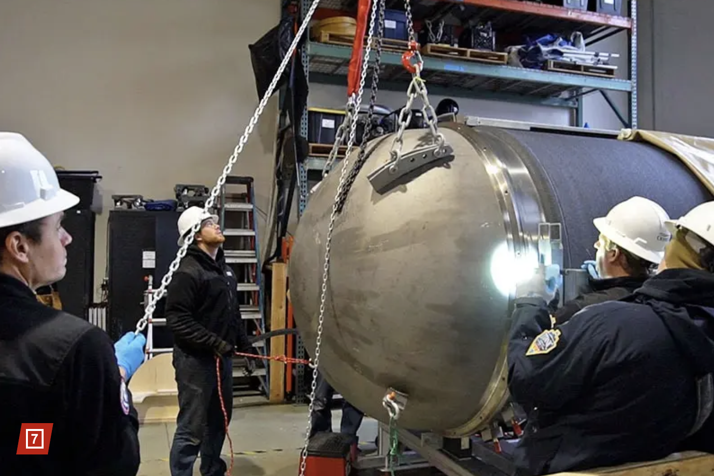
The carbon fibre hull built by the University of Washington Applied Physics from 2019, however for a hull designed for constructing “the shallow-water vessel” called Cyclops 1, made from different entirely materials–steel instead of the carbon fiber as was the case of the hull of the Titan–for diving 500 meters or 1,640 feet, not the 12,500 feet the Titanic lay (“APL-UW expertise involved only shallow water implementation, [and] the Laboratory was not involved in the design, engineering or testing of the TITAN submersible used in the RMS TITANIC expedition,” wrote the executive director of the UW Applied Physics Laboratory in a June 20, 2023 to distance himself from the OceanGate disaster into which he feared his laboratory was implicated, claiming it only offered its services for “shallow water implementation.” Yet Rush was explicit in noting that the college’s broad background in ocean engineering to develop “fixed and mobile ocean systems” for “deep ocean exploration” was always OceanGate’s final goal, and the laboratory claimed experience conducting research on the deep ocean floor that no doubt attracted Rush in the first place, as he sought help for OceanGate to build a submersible that in “the development, construction, launch, recovery, test and analysis of a deep-ocean, manned under-water vehicle.”   Rather than rooted in trade secrets that defined the enterprise of deepsea exploration, the carbon fiber hull, designed as if it were indeed a voyage to another planet and inexperienced space, recalls the Carl Sagan image sent to outer space for extraterrestrials, more than the ability to withstand tons of pressure, and multiple flaws in its assembly to withstand the pressures most engineers would quickly realize.

The confidence game that Rush was able to While David Lochbridge and his wife called OSHA every few weeks to alert them to the cracks, pops, and delimitation of the carbon-fibre hull that had been specially built for the submersible’s descent and the glue that bonded it to the titanium rings, by December 2018, Oceangate legal team demanded Lochbridge and his wife drop their complaints and the observations they offered on the plans for descending in the submersible. The legal team successfully delayed investigation of the craft that had never been certified by any third-party organization, as Lloyd’s Register or the American Bureau of Shipping, but was allowed to descend in international waters: the lawyers deflected any investigation by OSHA by charging Lochbridge with appropriating trade secrets, fraud, and theft; he had sought in vain the whistleblower protections from OSHA that never arrived-even as experts at the Marine Technology Society joined the DMO in raising safety concerns about the safety standards for the titanium hubs, evading the industry standards in March, 2018, ways likely to set back the entire industry of underseas exploration by “negative outcomes (from minor to catastrophic) that would have serious consequences for everyone in the industry.” While the cute submersible was promoted as able to navigate safely in any aquatic environment–but little intellectual property or “trade secrets” worthy of the name.

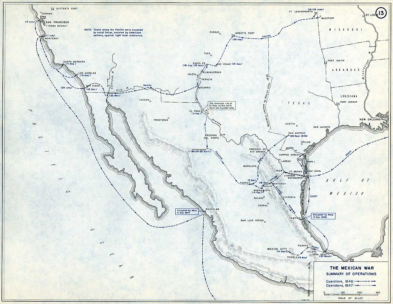
The questions that had been raised about its joins of tail cone or porthole and the degradation of the lamination of the carbon-fibre material, not used in arctic conditions, in winter weather of the waters off Newfoundland evaded the regulatory frameworks in place for national or international rates. Did Rush realize that the lack of oversight in international waters off of Newfoundland where the Titanic had previously sunk allowed the escape hatch he needed to press full speed ahead with plans that many doubted would be able to sustain deep-ocean pressures, let alone those on the ocean floor? The Titan, of course, never reached that ocean floor destination, as it had advertised.

Experts Worried the Laminated Carbon Fiber Hull would not Withstand Pressures on Ocean Floor

This was not under the radar. Ocean Governance was evaded as Rush was working without any oversight to fabricate a submersible he claimed was able to withstand underseas pressure based on his own engineering training alone, and his zeal to conduct underseas missions at the ocean floor. By insulating himself with pseudo-experts–from Pierre Nageolet, working outside of deepsea protocols in place for some time in engineering communities, and silencing his whistblower by intimidatory tactics of actual or threatened lawsuits, who he quickly sacked without grounds, And while the U.S. Coast Guard has determined that the almost instantaneous explosion of The Titan, the submersible Rush helped design and whose construction he single-handedly supervised and oversaw resulted from a failure in the glue joining the hull and titanium ring, or the carbon fiber hull’s delimitation as a result of wintering in the north seas, the simulation of how the submersible en route to carry passengers to the ruins of the HMS Titanic after an hour and forty-five minutes may have been a “painless death,” the four days of panic as to its fate conceal the deep dangers of lack of safety oversight or regulations in an almost unregulated search for underseas minerals that seems to have driven Rush’s rather single-minded pursuit of a way to explore underwater canyons on the ocean floor and deepsea territories long hidden to the human observer.

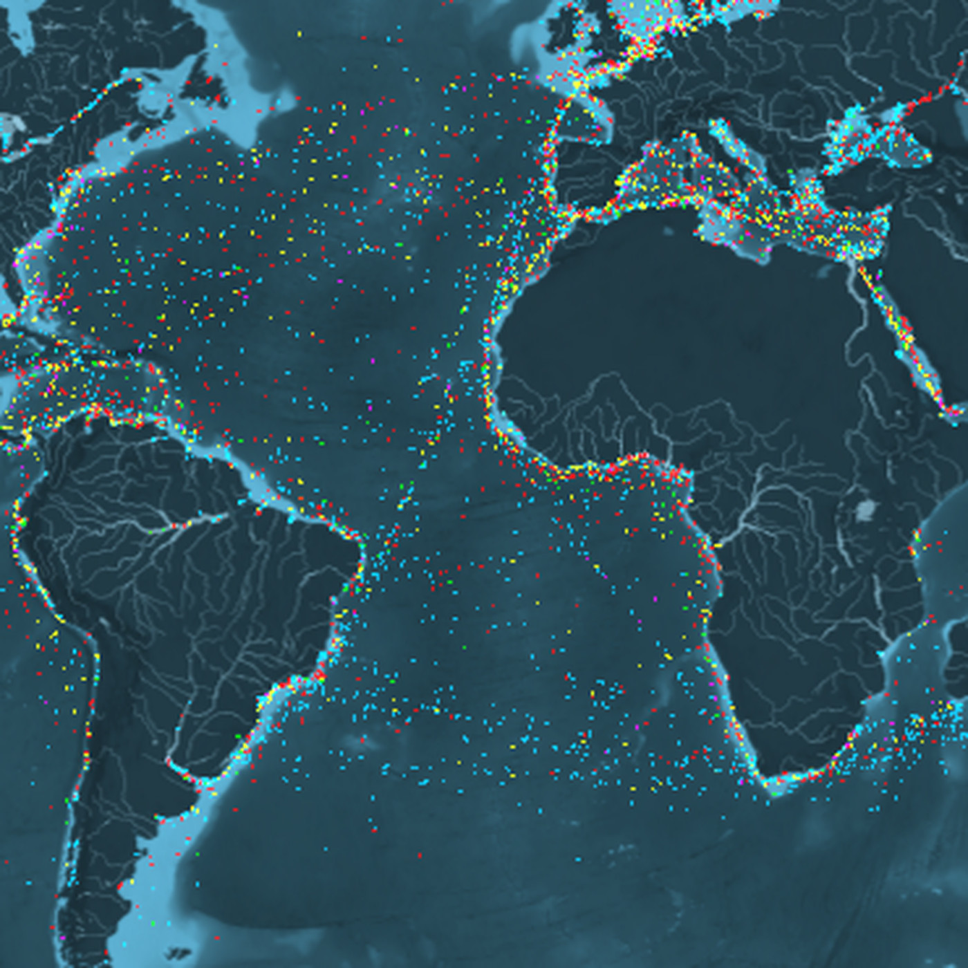
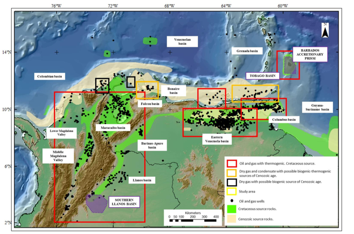
The exploration of the underseas, as much as following Jules Verne’s nineteenth century adventure books, was driven by a growing market for mineral and energy speculation as much as personal glory. If the truly catastrophic implosion of the submersible lasted but milliseconds–too quick of the mind to process, per YouTube sensation Dr. Chris Rayner, who has most recently piggybacked on the global catastrophe, asserts. If the hull collapse may have been preceded by squeaks and pops that inspired panic,  the possible site of collapse and structural failure—the viewport, the adhesive seal between the titanium end-caps and the collapse of the cylindrical hull–resulted from evading oversight of nautical regulatory bodies, perhaps steeped in the ethos of American individualism, but driven by a market for offering new platforms of first-hand underseas oil exploration to oil companies and engineers in search of deep sea minerals–the very community of engineers Rush hoped to win over for the benefits of the submersible as a mode of underseas mapping. The need to evade the law of the seas, and situate the site of exploration in international waters, was situated at the ruins of the Titanic to attract worldwide media attention, and pull other outsiders into Rush’s outsider project, evading any regulatory commissions or guidelines on passenger safety. All of Rush’s passengers had of course signed release forms prior to boarding the Titan, and the pressures to which it was exposed that reached 5,000 pounds of pressure per square inch. Carbon fibre was an “unpredictable material” all along for such depths of 3,000 feet, if not an impractical one, raising questions of why Rush was so committed to allowing multiple untested features to remain before performing the dive, advertising the ride to passengers he would take to their deaths as entirely safe.

1. The romance of the underseas exploration was clearly intensified–and made attractive to financial backers–by the nature of its destination: the ruins of the Titanic–and, however paradoxically, the ability to transcend death. The expression of a desire to transcend perceived boundaries was communicated to Stockton Rush as a boy in Walden, or Maine Woods, where Thoreau waxed ecstatic at an almost mythic awareness of something “vast, Titanic, such as man never inhabits”–channeled by the original transatlantic transatlantic voyage that mirrored the telegraph to the Newfoundland coast, before hitting an iceberg, to the search of the steel ruins still lying submerged undersea. Rush sought to break new boundaries of the globalized world by the venture of OceanGate, as if breaching new frontier of exploration, if not an affirmation of personal vitality and renewal by traveling to a space “such as man never inhabits,” where “inhuman Nature has got him alone.” It is impossible to read the ecstatic revery of how Nature moves man and “pilfers him of some of his divine faculty” as an open invitation to descend into the deep of the ruins of the Titanic, to relive the massive tragedy of the first decades of the twentieth century, as attempting to reconquer time.)

Stockton Rush had recuperated a narrative of canasta with deep roots, if one that was promoted in the recent films that had become museum shows and even adventure rids at amusement parks–but this, as if in contrast to studio recreations, was promised as the utmost exhilaration of the real thing. But was it ever reality, so entangled was Rush’s promise with beliefs in transcendence that trained generations of readers of Thoreau to search for sites of transcendence beyond our abilities? Or is the fiction of transcendence that Rush promised to paying customers, and that Thoreau had so memorably inspired, gained new meanings in a world defined by globalization, where the voyage of Stockton Rush into the depth of international waters, outside legal oversight, been tainted by the map of globalization, and indeed inspired by the abilities to transcend our own known limits were newly conflated with the transcendence of legal regimes, and indeed the transcendence of limits of deepwater exploration for energy reserves that oil and gas multinationals hoped to extract from the deep seas, but lacked the requisite technology to survey? For the voyage in the modern diving bell was indeed a trial balloon to industries eager for tools of underseas mapping promising greater precision, that it isn’t unlikely to think Ocean’s Gate was eager to market, for far more money than offering exerting underseas joy rides of disaster tourism. And a very different if related sense of “Titanic’ that Thoreau used in Maine Woods, of something that “was vast, Titanic, and such as man never inhabits” where “Nature has got him at a disadvantage” might better describe the deep seas.

The bravura of descending by a diving bell had been memorably used in the mid-century novel Dr. Faustus by Thomas Mann as an aesthetic experiencetragically tainted by hubris from the start. Mann seeks to express the Faustian goals of his hero, Adrian Leverkühn by the diving bell he travels undresea to witness unknown monsters in perfect submarine darkness, far from humanity, in the diving bell that prefigure the ecstatic aspirations to symphonies he hopes to create. The trips with Dr. Capercale to the underseas world with a fictional scientist, as pushing the limits of human understanding. Leverkühn claims to have experienced new limits when he descended in the waters off Bermuda, only several sea miles from St. George, in the company of a man who claims to “have set a new record for depth” underwater. Mann’s memorable hero descended in a “bullet-shaped diving-bell” that transcended human limits, descending a if in inverse to the stratospheric balloon it resembled, promised to be “absolutely watertight, . . . capable of withstanding the immense pressures and came equipped with plenty of oxygen, a telephone, high-powered searchlights, and quartz windows for viewing on every side.” If ‘anything but comfortable” they were secure in their descent, “by the knowledge of their safety . . . beneath he surface of the ocean” behind four-hundred pound door, as descending to perfect darkness at 2,000 and then 2,500 feet, bearing 500,000 tons of pressure.

Leverkühn somewhat cozily entertained his friends with gusto of the descent to underseas depths, smoking a cigarette. The voyage was a metaphor for the modern Faustian bargain he made with the Devil, sacrificing human love for his skills of composition. For in the descent to the inhuman realm, he described having gained “glimpses afforded onto a world whose silent, alien madness was justified–and explained, so to speak–by its inherent lack of contact with our own” in the descending chamber, in three hours that “passed like a dream, thanks to the . . . glimpses into a world whose soundless, frantic foreignness was explained . . . by its [absolute and] utter lack of contact with our own:” “all around reigned perfect blackness” akin to “darkness of interstellar space.” Diving bells not only provided visits to witness sunken wrecks off Bermuda’s coast on the ocean floor, but conjured a transcendence of the human, in an unmapped region beyond the limits of the known, traveling 3600 feet below the seas surface in a two-and-a-half ton hollow ball for a half an hour, looking through quartz windows “into a blue-blackness hard to describe, . . . eternally still . . . not quite allayed by the feeling science must be allowed to press just as far forwards as the intelligence of scientists is given license to go.”

Else Bostelmann, Dragonfish or “Bathysphere Intact” off Bermuda (1934)

The images Else Bostelmann offered in scientific periodicals captured the fascination of underseas that colonized the imagination; “the incredible oddities that nature and life had managed here, these forms and physiognomies that seemed to bear scarcely any kinship with those on earth above and to belong to some other planet, . . . hidden in eternal darkness.” The deep sea hid “these abstruse creatures of the abyss” that seem “to have no tie to humanity” provided the first ken of the pleasure Leverkühn takes in flaunting familiarity “his experiences in regions monstrously above and beyond us humans,” plunging with diabolic relish and ease among the “deep-sea’s life grottesquely alien life-forms, which did not seem to belong to our planet.” His friend thinks that the indulgence of these memories seemed “a devilish prank” of “the horridities of creation” able spur him to a new form of composition of the “cosmic music, with which he had become preoccupied,” before World War I, in compositions the narrator condemns as a “sardonic lampoon apparently aimed not only at the dreadful clockwork of the universe, but also at the medium in which it is painted . . . at music” of “a nearly thirty-minute orchestral portrait of the world is mockery–a mockery that confirms only too well the opinion I expressed in our conversation that the pursuit of what is immeasurably beyond man can provide no piety or nourishment.”

The sense of an infernal voyage was amplified in the disaster on the way to visit the Titanic’s ruins. For that voyage was akin to the blasphemic nature of what Mann’s narrator calls aLuciferian travesty” and blasphemy against the elevated medium of music expressed–or mapped?–by artistic ambitions to transcend the human world. For Mann, writing in global war during the 1940s, the desire of Leverkühn seems one of technology and modernity that might be captured by Adorno, whose music criticism he had pillaged in the novel–deeply human problems of alienation that plagued the mid-twentieth century and Nazi period. These musical compositions, after all, confirm Leverkühn’s own diabolic pact, only hinted at or foreshadowed in the book’s earlier chapters. The imagined underseas voyage was a voyage to the unknown depths of the ocean provides the basis for describing his imagined trips to outer space; the orchestral fantasia suggest horror in the ears of his admiring friend, for a Godless vision to dethrone all religious humanism of a search for music able to describe the terrible marvels of outer-space or grotesqueries of the deep.

The Faustian nature of Stockton Rush’s quest was nothing if not a Faust-like underbelly of globalization, this post argues, piggy-backing on Mann’s shoulders for a bit, from the perspective of globalization and deregulation that open up the deep with even more terror. While Mann will be less a focus of the post, I will follow him in examining and descending into the terror opening up of ideas and imaginations of prospecting the ocean’s floor multinational firms of opened by hopes of prospecting. For the huge bonanzas of extraction have opened up new deepwater spaces, as access to the deepwater reserves of energy or rare metals provide secret promises to an eternal ability of extraction, a search for energy sources that is a broader Faustian problem by Big Oil we can only see, but is almost engraved in the desperation on his face as he readies to plunge to the ocean floor.

The Faustian nature of the deepwater voyage within the curved steel walls of a cast iron Bathysphere had been devised to protect the biologist William Bebe and his assistant from the dark, boasted to guarantee against the heightened pressures of ocean depths few had experienced or would survive. The thrill of the deep seas plunge that exposed the vessel to such enormous atmospheric pressure left in the composer the sense of risk in his skin–a “prickly sensation that came with realizing one was exposing to sight what had never been seen, was not to be seen, and had never expected to be seen” whose unavoidable “sense of indiscretion, indeed of sinfulness, could not be fully mitigated and neutralized [even] by the exhilaration of science.” Ocean scientist and engineer Bebe gained nearly global attention for his exploration of deep ocean life behind two fused eight-inch quartz portholes in 1934,–a new horizon on uninhabited worlds electric light was able to reveal to human sight as a technological wonder of observation, a new sort of scope regime. The biologist reported observations be telephone to a nearby boat–for Mann, a bestiary of “mad grotesqueries, organic nature’s secret faces: predatory mouths, shameless teeth, telescopic eyes; paper nautiluses, hatchetfish with goggles aimed upward, heteropods and sea butterflies up to six feet long.” The descriptive relish of revealing this hidden bestiary cannot capture the strangeness Else Bostelmann imagined for National Geographic of the deep sea life illuminated in the Bathysphere she never participated. But thirty-five pioneering dives were conducted, many years after the Titanic sunk in the far colder waters off Newfoundland, its starboard air chambers shattered as they hit an iceberg.

The transport Adrian Leverkühn imagined might be conveyed in Bebe’s ambitions to view “here, under a pressure which, if loosened, would make amorphous tissue of a human being . . . here I was privileged to sit and crystallize something useful.” The sturdy Bathysphere set records descending to 1,200 feet; diving spheres soon plunged to 4,500 ft., if only a third of the way to the 12, 500 feet at which the Titanic had sunk. The deepwater voyages became the subject of a popular film by 1938,–perhaps as popular as the recent blockbuster of Titanic’s sinking–and a spectacle of the revelation of the uncanny creatures of the Deep Sea, capturing the excessive hope that in part animated Stockton Rush in his own fantasia–if it didn’t hint that he wasn’t driven only by science or exploration, but monetary profit, revealing the huge financial benefits of surveying the underseas world in an age of globalization that threatens to expose more and more underseas minerals to hopes of extraction, in a Faustian bargain we have not yet come to contemplate fully but is increasingly waged in maps, and cartographic precision to map sites of extraction underseas.

The absolute alien nature of the darkest reaches of undersea life must have epitomized the Faustian bargain of Leverkühn, eager to court danger of the inhumane for renown. Thomas Mann was in fact describing the underseas as an inevitable attraction for the composer who made a deal with Satan in Dr. Faustus (1946), one imagines akin to the compulsive attraction with which Stockton Rush persued th e deep. The plunge below 4,000 feet was sufficient other-worldly to recall a pact with the devil, as the idea of descending and returning to the underseas graveyard of the Titanic’s ruins.

Yet the attempt to market underseas heroism of tempting fate that Stockton Rush offered the passengers of the submersible he called ‘Titan’ never did reveal “what genuine underseas exploration looks like;” its passengers all met with death. Mann described the eery inhumanity of a descent below 2,400 and 2,500 feet, opening “an interstellar space unvisited for eternities by even the weakest ray of sun,” to be “examined under a brutal artificial beam, . . . brought down from the world above” as a bridging of life and death. Rush’s unwarranted promise of survival in such a transit to the deepsea ruins is however akin to how Leverkühn courting exhilaration before “forms and physiognomies that seemed to bear scarcely any kinship with those on the earth above and to belong to some other planet,” unveiling not “products of concealment . . . hidden in eternal darkness” compared only to “the arrival of a human space-craft on Mars.” But what Rush promised was underwritten and sponsored by a deeper diabolic pact of hoping to sell the submersible to multinationals after its media success for use prospecting oil and precious metals below the sea we are unable to map.

Continue reading

Leave a comment

Filed under deregulation, maritime safety, ocean mapping, Titanic, undersea exploration

Venezuela’s Terribly Slippery Sovereignty

Almost unnoticed in the current crisis of who is the real sovereign of Venezuela is that national maps fail to show the remove of sovereign power from territorial bounds. Even as blockades obstruct borders, closing points of entry and ports from entering Venezuela, the pressure that push the Venezuelan people into dire economic straits underlie the map of its population, lying deep, deep within the ground beneath their feet. The ties of this underground offshore sovereignty, lying deep in oil deposits located in sandy regions or in sandstone basins, suggest the scale of redrawing sovereignty in an age of globalization–when the nature of what lies offshore can becomes a rational for globalized conflict.

The precarious claims of petrosovereignty are hard to map, but as the reserves in the Orinoco Basin and offshore on the continental shelf are leveraged against a global energy market, the real sovereignty of Venezuela–and the tensions manifested on Venezuela’s national boundaries–have become a touchstone and trigger point of global attention as the nation’s huge oil reserves held by Petroleos de Venezuela SA (PdVSA) have made the legitimacy of the nation’s Presidential election a topic of global divides.

The infographic that has gained such wide circulation in differing forms transposes the red/blue divide of the election of Venezuela’s President, as I noted in an earlier post, on a global map, in ways that barely skim the surface in suggesting the truly global consequences in which the election is understood as less by geopolitics–the ostensible reason for America’s increasing attention to its results, according to John Bolton, in a policy that extends back to the Monroe Doctrine, of preserving democracy’s expanse across our own hemisphere, but global energy markets.

The Venezuelan tragedy is local, but crises of immigration, economy, and public health seems undergirded by the corollaries of globalization–and how globalization both erases boundaries, and puts pressures on defining them, and invests huge significance on defining the “boundary” even if it has become something of an empty fetish in maps. If oil and gas were made central to Venezuelan sovereignty by Simon Bolivar, it is increasingly linked to global webs of oil exports and ties of international commerce–visible in the petroleum tankers marked by red dots in a visualization of global shipping routes–that have refracted and become a basis to interpret the question of Venezuela’s sovereignty, and in which the future of its economy and the future of its sovereignty are unavoidably entangled and enmeshed.

 Red dots are oil rigs in interactive map, courtesy UCL Energy Institute/Map: KILN

For the crisis that is unfolding against the economic backdrop of a precipitous drop of wages, goods, and basic human and health services suggests one tied to ripples in a global energy market. For as much as Venezuelan sovereignty was long based in the “bituminous belt” of the Orinoco Basin, whose expanse exceeds the oil in all of Saudi Arabia–

–located in the Eastern Venezuela Basin in the Orinoco Belt, surveyed as recently as 2010 by USGS as the Venezuelan government of Maduro’s predecessor Hugo Chávez took bids from Chevron and others to help finance exploration projects in the Orinoco Belt, seat of the world’s largest reserves, in a basin extending quite far offshore, in quite dense jungle.

USGS, 2010

Venezuela has long seen its petroleum sovereignty as the source of its regional independence, and of needed cash influx from multi-national corporations with whom its nationalized Petroleos de Venezuela SA–PdVSA–undertakes strategic partnerships, including Exxon and Gazprom (Russia), Sincor (China), and Belarusneft, as American multinationals were pushed out of the heavy oil-rich Orinoco Valley during the Chávez regime. The evolution of multiple “strategic alliances” in mining and oil and gas speculation with over a hundred and fifty companies from thirty-five nations led to an expansion of foreign involvement in oil extraction and gold and mineral mining that has created a lamination over the region–

–that provides a complex lens to examine the refraction of its sovereign status, and the global geostrategic importance of the region to the globalized world.

Venezuela’s sovereignty is viewed as so closely tied to global energy markets that invocation of hemispheric dominance and the American “Monroe doctrine” truly seem only so much lip service–if it weren’t for the huge access to oil reserves that the sovereignty of Venezuela will determine who has access to these reserves. And much as the earliest mapping of the same region of South America combined the rich natural hydrogeography of the curving river basin that snaked through the territory with missions who had colonized the land, to convert its inhabitants, in the region of Granada–note the jesuit presence above the equatorial line–

Libarary of Congress, Map of the Province and Missions of the Company of Jesus in the New Kingdom of Granada

–the new presence on the Orinoco Basin are transnational oil companies, and repossession of their extractive wealth has provided a basis for not only nationalism, but Although their stewardship of the delicate ecosystem of the Orinoco may be doubted, as charges of a crude oil spill in the region that would be so disastrous to its ecosystem has created a specter of ecological disaster for several years that PdVSA has steadfastly denied, despite the threats of accelerated deforestation, pollution, and extinction that mining and oil accidents portend in the Guyana highlands: Maduro has claimed mining and oil extraction are now “environmentally friendly,” but satellite images have shown the extent of deforestation into once-protected areas. Little of the protected regions are actually protected as the economy has fallen into free-fall and pressure to extract gold from the region brought increasing use of mercury in mineral mills, despite a Presidential ban, and the erosion of legal enforcement on workers in the region. Although PdVSA has asserted that leaking of over 100,000 barrels of oil from local pipelines did not enter the Orinoco, but was contained in the Anzoategui province in 2016, the extent of environmental devastation may only be understood in future years across the “Strategic Mining Belt” south of the Orinoco, where the Orinoco’s major watersheds lie, where gold, iron, copper, and bauxite feed the cash reserves of the government as well as oil.

Indeed, as we consider

Virginia Behm, ESRI Story Map: The Orinoco Mineral Arc and Mega-Mining in the Amazon

In an age when we increasingly form interactive maps in terms of the information we desire at the moment–and the needs that this information can provide–perhaps Trump is the sort of executive we deserve, framing information by infographics he can grasp on demand, rather than motivated by universal ideals. After the Venezuelan “economic miracle” grew by oil from 2004-2008, Maduro had declared his own state of emergency in Venezuela, back in 2016, when American intelligence predicted his time in office was only a matter of time, as inflation neared 180% and GDP fell to levels before 2004. But increasing exports to China and Russia sent a lifeline, despite shrinking foreign exchange reserves, of which Trump and Bolton are no doubt extremely attentive observers–even before PdVSA moved its European offices to Moscow in early March.

While cast to reach 100,000%, the peaking of vertiginous levels of hyperinflation near 41,838% led economic data to be closed to the public, as all revenue sources dwindle or vanish, and all foreign aid is refused by the Maduro government, as all question of a coup increasingly uncertain as most of the country is living in poverty, and a fifth of PdVSA is laid off–raising questions about the fate of extractive industries and the continued safety of existing oil reserves that are inseparable from state sovereignty.

Venezuela’s sovereign wealth extends globally, if it is located deep underground. But the long-cultivated dependence of the United States, where heavy crude flows to three refineries, which supply over 5,000 retail stations in twenty seven states, has created a question of linked economies which our ADD-afflicted President is now doubt attentive: CITGO plants along the Gulf Coast and eastern seaboard run against according independence to sovereign state in a globalized economy–a tie that President Trump would want to keep alive, and indeed that the impact of a sudden shock an absence of oil flowing in its nine pipelines would create.

The flows of oil have blurred Venezuelan sovereignty, and allegedly led Donald Trump to ask advisors repeatedly why American couldn’t invade the nation in August, 2017, stunning former Secretary of State Rex Tillerson and former National Security Advisor Clapper, as American sanctions against the nation were discussed, and then again to float the question with Latin American leaders, including the President of Colombia, after addressing the U.N.’s General Assembly, to make sure none wanted to oust Maduro as President. Global energy supplies have created a lens by which the “legitimacy” of Venezuela’s government and Presidency is questioned that has overriden constitutional practices sanctioned by Venezuelan law.

The crisis of immigration on our southern border notwithstanding, the fear of a crisis in oil important have encouraged the United States to invoke the arrival of a “crisis situation” in Venezuelan internal politics, that allows action outside the rule of established Venezuelan law of due process Trump’s eagerness to recognize Guaidó as “interim President of Venezuela” on January 23, shortly after Maduro assume the and declaration, before any other nation, of readiness to use “the full weight of United States economic and diplomatic power to press for the restoration of Venezuelan democracy,” as he encouraged other governments to follow suit. As Bolton works to distill Presidential Daily Briefings on global intelligence into a form that is more amenable to his chief executive–“big points and, wherever possible, graphics,” as James Clapper put it–energy markets are the basic map on which he seems to be informing himself about global politics. Mike Pompeo noted that President Trump is said to “dig deeper” into his President’s Daily Briefing about Venezuela to assess the “real layout” of “what was really taking place” there–who had the money? where was the debt?  who stood to loose and gain?–led to open questioning of the legitimacy of Nicolás Maduro.

At a time when 8.36 million barrels of heavy crude managed by PdVSA–the state-owned oil and gas conglomerate, Petroleos de Venezuela SA–which is worth half a billion American dollars lay off in tankers nation’s shoreline, in national waters, ready to ship to refineries to be processed by Chevron, Valero Energy Corp. and Rosneft, but with no place to ship the heavy oil, the local and global seem to intersect in globalized energy markets.

Tankers Holding Venezuelan Oil off Venezuela’s shoreline

As Clapper remembered Trump’s preference in Daily Briefings for charts and data visualizations quite early on, the distilling of the Presidential Daily Briefings by John Bolton into America’s bottom-line interests may compel re-examination of the place of the nation in a global energy market, and his sense of the value of the region’s geography to American national interests. Mike Pompeo, current secretary of state, has similarly described the need to reduce global conflict to the bottom-line of America’s economic interests for Trump, given his dislike for distilling the PDB to American interests, the Venezuelan crisis may more easily be understood by infographics or “mapped” as a global calculus of oil exports, rather than a defense of democratic principles. Trump has increasingly asked, Pompeo remembered, with interest for “more clarity” on financial issues–“Who had the money, where was the debt, what was the timing of that?”–aware, as the self-proclaimed “King of Debt,” of how debt, too, structures sovereignty, and deeply aware of the US$60 billion in foreign debt the nation carried–a massive amount that has grown almost six-fold in recent years, as oil exports from the nation increasingly grow, and Russia and China invested increasing sums in its oil exports as the debt grew.

Of public sector debt above $184.5 billion, $60 billion is foreign debt, though smaller numbers are claimed by the Venezuelan Central Bank 

–no doubt fascinated that the submerged collateral of such huge oil and gas deposits allowed the debt to grow to unprecedented height, as the exodus of refugees leaving Venezuela’s borders grew. Indeed, we focus on the fate of refugees, and cross-border flows, as a humanitarian crisis, but on which we focus more than the flow of extracted minerals, oil, and gas that have spread out to the world, and the arrival of capital from global sources as energy exports grow.

The sovereignty of the state was long tied to the concentration of oil and gas fields in sedimentary basins of northern Venezuela and South America–and which are the understory of the global attention to results of the election. As much as they are rooted in ideological debates of socialism and free market advocates, one needs to made sense of what “what was really taking place” in much of the Eastern Venezuela Basin and Columbus Basin to parse the deep interest in Venezuela’s sovereignty–and indeed to drill down, literally, into what Venezuelan sovereignty meant for the United States.

For the protection of those reserves led U.S. Secretary of State Pompeo-former director of the CIA–to try to entice Venezuela’s own armed forces to remove Maduro as President on January 28, 2019, as Trump helped assemble hemispheric powers to deny Maduro’s legitimacy. And it has led Donald Trump to advocate gunboat diplomacy by asking aides about benefits of a “military option” they openly called analogous to the 1989 Invasion of Panama when 9,000 troops toppled dictator Manuel Noriega, with 12,000 military already stationed in the nation, after Noriega had annulled a popular election, denying foreign sovereignty in the Panama Canal Zone with little military resistance of Panamanian Defense Forces. If America seeks to achieve a similar shift of sovereignty, hoping to echo the use of military force to topple Noriega–years after he was installed as leader of Panama to stop a feared spread of Communism in 1970—due to charges of Cuban collaboration, rather than money laundering and long involvement in the drug trade, such arrogant denial of sovereignty of other states in the hemisphere would not be so lopsided an engagement of force, or so smooth.

“Soberana” or “sovereign” is somewhat ironically the now-obsolete brand-name for a beer popular in Panama, now updated, which hung from the store-front of a Panama street American forces occupied back in 1989–

–the questions of the legitimacy of Venezuelan sovereignty are deeply intertwined with the offshore drilling rights that American oil companies are eager to acquire–or repossess–and underlie the denials of the legitimate sovereignty of elected leader Nicolás Maduro. The powerful evocation of the map

The American demonization of Mauro as military dictator erases the basis of Venezuelan sovereignty and a patrimony of petroleum, from Bolivarian models of sovereign economic independence; if oil is the source of 95% of the currency provided to the government, and was long seen as a gift from God to the Venezuelan independence at the heart of Socialist prosperity–

–the ties between the oil company and oil extraction and the nation grew hen Maduro declared personal leadership of PDVSA before the National Assembly in January, 2019, on the eve of his country’s assumption of OPEC presidency, as General Manuel Quevedo–a man without oil industry experience but a close Maduro military ally from the National Guard–assumes presidency of the global cartel OPEC, with ambitions of using OPEC to affirm Maduro’s swearing in as President, and his status as a defender of retro-sovereignty as counter-weight to the United States on a global stage–as the leader of sustaining the global prices of oil, offsetting the fall in prices with the increased production of shale-derived oil in the United States from 2014 that had caused a problem for Venezuela’s national wealth, and removing oil from the hegemony of dollar prices by cryptocurrencies as Venezuela’s own oil and mineral-backed Petro,

as well as by tying them to Chinese Yuan, in the face of growing US sanctions that Trump announced as Maduro heralded the digital currency as a way to affirm his nation’s “monetary sovereignty, to make [global] financial transactions, and overcome the financial blockade” imposed by the United States on investors, which led Trump to impose further sanctions on electronic transfers from by Americans in 2018, after the Petro netted $5 billion from American investors. The hope of decoupling from the US dollar was allowed by the transfer of the 30,000 million barrels of oil in the Orinoco Belt to the Venezuelan Central Bank as collateral for the hoped-for cryptocurrency–itself a proclamation of the national ownership of oil reserves that the current struggle for Presidential legitimacy would contest.

The map of national sovereignty onto the petroleum reserves was engraved in the public’s mind on oil and gas tanks that dot the coast and interior–

–even if may of the drilling projects are in fact joint ventures of PdVSA with other nations, from multinational based in Russia (Gazprom) to China (Sincor) to Belarus to Brazil (Petrobras) to Argentina (Repsol-YPF) to Uruguay (ANCAP & ENSARA)–and image of the deep-seated globalism of the Venezuelan oil economy, whose extraction of heavy underground oil is to be piped from the Orinoco Basin to ships waiting off the coast to be refined.

As Maduro tries to reaffirm the notion of petroleum sovereignty–the slogan of Bolivarian socialism is soberania petrolera–rooted in fashioning Venezuela as a global energy power, is there a logic of the staking of war for the offshore? The alleged fear Noriega collaborated with Cuba was voiced from 1986, and offered a rational for the “Christmas-time” invasion of December 20-24, 1989, as much as Noriega’s indictment for drug trafficking, although this was the reason for his eventual arrest by the DEA. The spectacularly lopsided and unrisky military deployment of 26,000 U.S. troops in “Operation Just Cause” against the Panamanian police force is a scenario, of course, quite unlike the threat of American invasion of Venezuela, a larger sovereign nation, not without its own armed forces–an invasion of which would provide far more expansive hemispheric consequences, as the scale of targeting Chávez’ appropriation of economic property. Yet Trump thirty years later in mid-February 2019 invoked the need to end Venezuela’s “humanitarian disaster” in Florida, beside Venezuelan refugees beside an American and Venezuelan flag, to inveigh against “Dictator Maduro” as being–hear the echo–a “Cuban puppet” for blocking the arrival of aid, and describing “our neighbor” Venezuela in ways that recall Panama.

In Florida, Trump threateningly observed that “we have troops all over the world in places that are very, very far away [and] Venezuela is not that far away,” while privately asking advisors if invasion wouldn’t resolve threat of Venezuela’s economic collapse. As FOXTV states that the refugee crisis in Venezuela–a political, humanitarian, and economic crisis, to be sure–could “match the scale of Syria’s catastrophe,” and as sanctions imposed on Venezuela have helped precipitate an exodus that unfolded over the previous years, he was quite eager to suggest military options, in ways that give his declarations of geographical proximity particularly disquieting.

The impromptu geography lesson had huge implications: “The people of Venezuela are standing for freedom and democracy and America is right by their side,” announced the American President in Miami, before flags of Venezuela and the United States and nationalist chants of “USA! USA!”

Maduro rightly feared coup, as Trump invited Venezuelan citizens in the “Maduro regime” to “end this nightmare of poverty, hunger and death” by a peaceful transition of power as Senator Marco Rubio tweeted images of Noriega on social media–as a specter of the bombast of Quadaffi and the criminality of Noriega, that “thug of a different era,” brought down by American troops.

Rubio’s tweet of head-shots of two thugs helped recall his creation of a niche of helping to design American foreign policy toward Venezuela: the echoes of the offshore in both Venezuela and Panama were perhaps the only element that might link them, for all the similarity of a Cuban connection Trump–who seems to have little familiarity with the region–supplied. The fear that “war for the offshore” may underlie Trump’s eagerness to entertain military options. Gen. Manuel Noriega had not only been on CIA rolls, but preserved access to a notion of the offshore-banking system about which we have learned in the Panama papers; the preservation of the offshore oil derricks that Exxon and Conoco had left in Venezuela in 2007, as well as in the Orinoco Belt, which PdVSA has presumably used new international partners to maintain since to pump viscous heavy oil for international use. Trump’s familiarity with Panama and its President may mostly be through hotels–the Trump International Panama was planned from 2005 opened in 2011, and is the tallest building in Latin America–but the invasion must have provided a point of entry for inaugurating the “fantastic building in a fantastic location” on beachfront property with then-president Ricardo Martinelli, who later fled to Miami, Florida to escape charges of embezzling public funds, and has only recently returned.

The local political dynamics are vastly different, despite some similarity in American eagerness to secure offshore sites: Maduro had won his Presidential election, whereas Noriega had annulled one, but the suggestion of toppling his regime undercut all sense of sovereign boundaries, was a clear parallel assertion of hemispheric dominance, to protect offshore assets. For all the lip service to Democracy and the Will of th People–Guadió was not really elected, although as head of the “Voluntad Popular” (Popular Will) party, and has declared himself as leader of opposition to Maduro in the National Assembly, with American blessings: after trying to direct the arrival of humanitarian aid into Venezuela, he met with Mike Pence in Bogota and President Lenin Moreno in Ecuador, but his success would open the offshore waters to American interests, and has been anointed President in one theater of public opinion–but in ways that break the world in ways that reflect continued accessibility to Venezuelan oil.


\

But the offshore benefits of a Guaidó Presidency to the United States may be as great as any benefits that he might be able to bring, at this point, to the Venezuelan people: they transcend surely ideology, economic prosperity–save in US aid–btu would be a viable way to reopen offshore Venezuelan oil reserves, and secure assets of ExxonMobil and ConocoPhilips that had been nationalized in the Chávez Socialist regime. With the Orinoco Belt resources, which transformed a marginal area of oil extraction into a particularly lucrative one in a short time, complemented the drive of Houston-based Conoco to retrieve $2B of assets of lost Venezuelan oil projects, only partly reimbursed as Conoco seized some offshore PdVSA rigs in the Dutch island of Curacoa, in May 2018; ExxonMobil and Hess were poised in 2017 to start drilling projects offshore of Guyana–including several regions Maduro has claimed as Venezuela’s sovereignty, if ones identified, in public maps show, to ExxonMobil’s and Shell’s ambitions for offshore drilling and exploration.

Oil Rig Reclaimed by Conoco in Curacao
6.6 Million Acres offshore Guyana being Explored by ExxonMobil/Hess Guyana/CNOOC in 2017/ ExxonMobil

Claims of Shell, Canadian Oil Company CGX and ExxonMobil Claims off Venezuelan Coast (April, 2017)

CGX Energy INterative Map

If there is a connection between Panama and Venezuela, is it in the prospect of invasion to protect role of the offshore assets so dominant in an age of globalization? If the comparison of invading Panama was widely entertained by military, U.S. bases not only lay in Panama, unlike Venezuela, but Venezuelan troops are loyal to the Maduro government, and any asymmetrical invasion with support from neighbors is unlikely. The attempts to delegitimize the election of Maduro, and his sovereign claims to offshore oil, with such finality have been an increasing goal of ensuring global claims to its petroleum sovereignty. Yet in an American administration that encouraged the expansion of offshore drilling, the arrogance of regarding sovereignty over offshore and inland black dots denoting oil and gas wells in the below map reveals the slipperiness of Venezuelan sovereignty, no doubt tied to the readiness of regarding them as an extension of our own energy security.


Based on A. Escalona and P Mann, Marine and Sedimentary Geology, v 28, 1 (2011)

And despite the heralding of waters offshore of Guyana as “the next big beast of global oil”–medium-light crude that is closer to major Middle East grades than United States shale-based oils, hoped to be rich in diesel when refined, the championing of Guyana as a next new site for oil extraction in late 2018, lies in a region that Venezuela has proclaimed as it sown, in a proclamation of uncertain enforcement, from 2015: ExxonMobil announced Stabroek blocks in 2015 and 2016 as a “world-class discovery” of up to a billion barrels of oil, as the Venezuelan government asserted it sovereignty over some of the exploration block, and has demanded that all exploration and development work be ceased until the international resolution of territorial boundaries.

ExxonMobil Oil Platform offshore of Guayana/Reuters

The continued dispute of the “offshore” and the state of Venezuelan sovereignty only increase the importance and significance of dismissing the legitimacy of the Maduro government in Trump’s America. The confusion of sovereign claims over the reserves sadly may underly full-throated blaming of other nations for “protecting” Maduro, as much as concerns for the Venezuelan people. Maduro in November, 2017, appointed his own National Guard major general—Manuel Quevedo, who lacked expertise in the oil industry—to run the national Oil Ministry and PdVSA, gathered with oil ministers in the Caracas headquarters to pray “for the recovery of the production of the industry,” the beleaguered company come under American attention, as the petroleum-technologies that remain in the region. Quevedo’s almost surreal level of inexperience in the oil industry has decreased oil production; and the decline of an established oil industry became seen as a question of American National Security, as army officials without familiarity with oil production meant that military managers have purged the industry of former executives, arresting former leaders, and appointed former military aides to supervisory positions.

National oil production plummeted by over half a million barrels from 2016-18, as maritime units entered critical mismanagement, more practiced executives and engineers left, many fleeing the country among three million displaced refugees, and oil production fell daily, as the National Guard assumed leadership positions–and foreigners invited to fill needed roles as infrastructure went unprepared, creating a time bomb dramatically reducing oil production by a million barrels per day from previous years–


BODI

–and reducing exports even far more severely, as far as an be gleaned from available PDVSA and OPEC records–

–but has created steepening anxiety about the futures of its oil exports.

How to map their decline against the increasingly slipperiness of sovereignty in Venezuela–undermined by economic catastrophe and lack of goods, as well as mismanagement–and on a global stage?

Deep confusion of sovereign claims over the reserves may underly full-throated blaming other nations for “protecting” Maduro–as much as concerns for the Venezuelan people. Although such calls for the legitimacy of Juan Guaidó’s self-declared Presidency present themselves as rooted in international consensus, Guaidó’s “Presidency” would pave the road for an increased access of American multinational companies to refine and extract oil from Venezuelan. The nationalization of oil has marginalized joint ventures with American companies and stands to diminish investment and servicing of rigs. Exxon has been barred from extraction by Maduro and its assets nationalized, and its exploratory ships confronted by Venezuela’s navy off Guyana’s coast; Shell has been trying to unload its stake in joint ventures on oil and gas with PdVSA; CITGO will cease to ship oil to America as American sanctions have struck the Venezuelan economy–the massive decline of venezuelan oil production stands to impact American gas prices.

The result is a scarily liquid sense of Venezuelan sovereignty. America entertained possibilities of a military coup openly from early 2018, and since the summer of 2017, seems to have led him to assemble pressure from Brazil, Peru, Guatemala and Honduras–leaders themselves not elected democratically–to endorse and call for regime change in Venezuela. The pressures created on Maduro’s claims to presidential sovereignty, and a national vision rooting sovereignty in mineral deposits and wealth have grown, as the nationalized oil and gas company has seemed close to collapsing.

Such a dated geopolitical spatial imaginary runs, however, directly against the longstanding centrality of Petróleos de Venezuela, S.A. (PDVSA) to national sovereignty of the state in exporting, manufacturing, and transporting crude oil and other hydrocarbons, and its central place in the sustainable and indeed “organic” development of Venezuela’s economy–and the longstanding celebration of the three hundred billion barrels of confirmed oil reserves verified in 2015 by Petroleum Intelligence Weekly, whose location is currently trumpeted on all holding tanks in maps of a natural resource fundamental to plans for the nation’s economic growth–and indeed a proclamation of their national ownership.

Map of Orinoco Belt Owned by PdVSA and Venezuelan Central Bank

Although the laminations of sovereignty reveal the problems of Venezuelan sovereignty or its legitimacy that are so evident in maps of border conflicts, cross-border migrations, or humanitarian crises across borders, the problems of sovereignty in a globalized oil market, whose prices are upset by Venezuela’s shrinking exports, but which have long focussed global attention on Venezuela’s sovereignty on a global scale, at the risk of eliding and omitting the crises of regional displacement, economic disruption, and human suffering that “humanitarian aid” can’t resolve.

A crisis of global proportions rooted in the circulation of underground and offshore goods of oil and gas offshore has created a crisis that has spilled over the nation’s borders, and undermined Venezuelan sovereignty and borders–and even created a state of exception that threatens to undermine the legitimacy of its political government. The sustained undermining of Maduro’s claims to authority as illegitimate, and as allowing the very “state of exception” that would allow the leader of the elected National Assembly to oversee the transition to a new government, and constitutional order, by calling for new elections, the need for a new sovereign power to control the rich oil deposits offshore and underground with speed and expedience by the hemispheric global energy conglomerates that have contracts with PdVSA–Shell; ExxonMobil; CITGO–to resolves cascading economic troubles in Venezuela by ending Maduro’s presidency as expediently as possible. The stakes of doing so would, as Tony Wood argued, run against Venezuelan law and overturn long-established procedures of political process.

As one is struggling by attempts to imagine the crises faced on the ground by refugees and displaced on Venezuela’s boundaries–many of who provide a quite different image of refugees than we have seen from the ravages of globalization–crossing bridges and fleeing frontier with down jackets and backpacks and water bottles, if without jobs, livelihoods, or residence–

Indeed, it may be that problems of the gears of global capital, less clearly visualized, despite a mastery of multiple scales of global mapping, has pushed the nation of Venezuela to such international prominence. Despite ever-increasing facility with switching between local, regional, and global scales of mapping, we however are less able to register the increased impact of shifts of global economic changes that manifest in the fetishization of the border, and its closure. It is as if despite the omniscient promises of Google Earth to take us to any site in a globalized world, we lack an ability to map global shifts that provoke displacement onto local crises. And as much as globalization creates renewed tensions around borders that are defended and redefined against global pressures, in which the question of Venezuelan sovereignty over offshore areas where many derricks are located, and where Venezuelan oil fields are located with easier access for global markets–

Continental Shelf of Venezuela (in blue-green cyan hue)

–the sovereignty of Venezuela stands to be upset for emergency reasons–in a “state of exception” or of emergency that is able to invest legitimacy in the very young leader of a very small minority political party, Juan Guaidó, who was trained in the United States in Washington, D.C., after opposition parties have subtracted themselves from the democratic process and boycotted recent elections, and the oil reserves in Venezuelan waters and the pipelines able to move heavy crude reserves lying under the Orinoco River into global energy markets or to refineries in the United States. Even as Venezuela has failed to create functioning cross-border pipelines to Colombia, or to Aruba, or even to meet its citizens’ needs in gas, the national oil and gas company, PdVSA, to place hopes on exporting gas for needed capital to an imagined market for exports from that same offshore region that sadly reflects the flow of displaced persons from its borders.

Gas Exports Planned by PdVSA, 2018

–that would link Venezuela through both gas pipelines (shown in red) and oil pipelines to Trinidad and Tobago, Brazil or to port towns, but are now inactive. Guaidó was quick to congratulate Bolsonaro on his victory in Brazil,


Synthesis of varied sources on pipless connecting Venezuela to Trinidad and Tobago and Brazil, planned oil pipelines in dotted green and gas pipelines in dotted red

The failure to use petroleum products to provide needed agrofertilizers that the nation once provided and exported with plastics and other mineral fuels that made up a substantial share of its GDP and national wealth, and the problems of integrating such offshore or inland projects of extraction to the “resto del mondo” in an efficient manner have created a deep cyclical crisis of economic hardships that we register now on its borders,–tied to the increased migration from Venezuela’s frontiers. But might these pressure be more accurately mapped as lying in the deep attachments of the nation’s sovereignty to reserves both offshore and underground? Even if support accorded either Maduro or Guaidó are described in most news markets and by the American President Donald J. Trump in ideological terms of socialism and populism, the underlying pressures of controlling Venezuela’s large oil reserves–and returning its productivity of oil and exports–created huge permeability of its borders, as oil output suddenly drastically declined.

The recent attempt to view the crisis as at the border where refugees and displaced have fled Venezuela at such a staggering rate–over three million Venezuelans have left its borders for other Latin American nations, leaving a million Venezuelans now residing in Colombia, among that nation’s eight displaced, as 5,000 left the nation daily during 2018—a boggling scale seen only as the result of war or huge natural disasters. The cascading numbers of displaced Venezuelans mirror the collapse of oil prices and oil industry–both of which have transformed the state’s boundaries, and transformed national borders into regions overcrowded with displaced refugees–

April 2018

–in ways that recent discussions of the “sovereignty” of Venezula have difficulty including in any discussion of the nation’s economic crisis or current future political uncertainty.

In response to these crises of migration, displacement, and economic decline, many frontiers have been closed to Venezuelans, and anger at Venezuelans has grown in many host countries, creating a humanitarian crisis far beyond Venezuela’s own frontiers. The promise of energy nationalization to provide a vision of “La Gran Venezuela” since 2007 rooted in an image of national autonomy has paradoxically led its national bounds to become more porous than ever, and threatened the national economy in ways that have destabilized its national borders, opening them to humanitarian crises and economic collapse, creating odd out-migrations, quite distinctive from most images of other global refugees or displaced.

Despite invocations of the sovereign desires of the Venezuelan people, symbolized by banner-like display of territorial maps, the struggles for sovereignty in Venezuela are more removed from ideology than one might believe, following most news media. For rather than the crisis being about cross-border flows, or the barriers to needed humanitarian aid poised to cross the border into Venezuela, the global attention to the crisis of sovereignty responds less to any on the ground situation, but rather about what is mapped offshore, under the ocean, and underneath the Orinoco Petroleum Belt and Basin. For in sites of potential extraction where most of Venezuela’s nearly three hundred billion barrels of heavy oil reserves lie sequestered deep underground in sandstone, in the largest in the world, and levels of petroleum extraction–long the basis for Venezuelan national wealth–which have currently fallen to levels not heard of since the 1940s, with disastrous results of paralyzing the national economy and affecting the global oil market.

Even as Venezuela finds itself increasingly subject to global pressures even as it assumes the presidency of OPEC, the Organization of Petroleum Exporting Countries. As current President Nicolás Maduro threatens to defend his nation’s place on a globalized international energy market, threatening to “substitute the United States with other countries,” to undermine the American economy and the stability of Donald Trump’s presidency, and American energy markets, the sovereignty of Venezuela is again threatened by an increasingly protectionist American government, eager to take action to keep energy prices down–keeping Venezuelan oil, long shipped to and refined in the United States by its North American subsidiary CITGO, providing tens of billions of gallons of crude oil flowing into American national energy pipelines and refineries.

As the infrastructure of oil production have either collapsed or vailed to be invested in and maintained in the nation, they have become an object of eager attention in the petroleum industry as reserves once easily able to be shipped to a global energy market have been remapped for nations that offering to provide new extractive technologies: since oil prices collapsed in 2014, the state-run oil company PdVSA without a plan or ability to invest in necessary infrastructure,–tragically echoing, perhaps, how Chavista policies hurt agrarian and agrochemical industries by short-sighted collectivization and appropriation without an effective working plan. As the rural regions often returned to something similar to subsistence farming, and uncertain future, the lack of maintaining many PdVSA rigs and derricks have created a crisis of sovereignty and capital in the nation, that demands to be better visualized and mapped.

Continue reading

Leave a comment

Filed under borders, energy independence, energy markets, national borders, Venezuela

Arctic Circles

On our annual northward migration to Ottawa this December, we gathered around the unused fireplace in an unheated living room during the warmest Canadian Christmas in personal experience–as well as in the public record for Atlantic Canada, where local records for rainfall have surpassed all earlier recorded years.  Perhaps because of this, discussion turned to ownership of the North Pole for the first time for some time, as what was formerly a featureless area of arctic ice has become, as a receding polar ice-sheet exposes possible sites of petroleum mining, to become an area of renewed land grabs and claims of territoriality, as their value for nations is primarily understood in a global market of energy prospecting.  

The story of the new mapping of territorial claims around the arctic ice cap goes back decades, to the exploration of offshore polar drilling, but the exposure of land raises new questions for mapping because boundaries of polar sovereignty are contested, even as oil companies have speculated by modeling sites of future exploration for petroleum deposits. In sharp contrast to the clear lines of sovereignty that were drawn along Antarctica, the ongoing disputes of the Arctic have become protracted indeed, only more contested as global warming and polar melting open the long-frozen shipping routes that have long been imagined across polar regions, opening up new fantasies and geographic imaginaries of globalization. While Antarctica remains sectorized with clear stability in the geopolitical maps per the C.I.A.’s World Factbook, the stability seven claims to ownership far less contested or open to international debate as no petroleum has been detected under the ice shelf, the southern lands that host McMurdo Station host stations occupied by sixteen governments, in a sort of tacit comity for goals of research, distributing rights but with both Russia and the United States refusing so far to recognize any as valid. And so although Argentina, Australia, Chile, France, New Zealand, Norway, and UK are eager to claim regions as their own, as if everyone can have a slice of the frozen pie, the lack of contestation and minimal interest in the sector between 90 degrees west and 150 degrees west stands in contrast to the intense mapping and remapping of the North Pole.

Maps are long primarily used as strategic tools to assert land claims and sovereign bounds. But this may seem increasingly foolhardy in an age that is defined by globalization, and where global warming seems to threaten to further blur the staking out of sovereign divides. Is this only another reason to the multiplication of assertions of arctic claims to melting lands? Although one assumption circulated that the place was Canadian by birthright—birthright to the Arctic?–since it is so central to national mythistory.  

But there’s as much validity for its claims as the more strident claim the explorer Artur Chilingarov made to justify his planting of a Russian tricolor in the murky ocean bed 2.5 miles below the North Pole, during the 2007 polar expedition of the Mir submarine, with the timeless claim of Soviet-era bluntness, “The Arctic has always been Russian.”  Canadian PM Steven Harper did not hesitate a bit before decrying these claims to territoriality, warning his nation of the danger of Russian plans for incursions into the arctic in his tour of Canada’s North, thumping his chest and professing ongoing vigilance against Russia’s “imperial” arctic “imperial” as a national affront in addressing troops participating in military maneuvers off Baffin island as recently as in 2014.

Harper’s speech might have recalled the first proposal to carve pie-shaped regions in a sectorization of the North Pole first made by the early twentieth-century Canadian senator, the honorable Pascal Poirier, when he full-throatedly proposed to stake Canada’s sovereign claims to land “right up to the pole” and transform what had been a terra nullius into an image of objective territory seemed once again at stake.  Poirier claimed jurisdictional contiguity in declaring “possession of all lands and islands situated in the north of the Dominion.”  Poirier’s project of sectorizing the frozen arctic sea and its islands, first launched shortly after Peary’s polar expedition, has regained its relevance in an age of global warming, arctic melting and climate change.  But the reaction to the expanding Arctic Ocean in a language of access to a market of commodities has inflected and infected his discussion of the rights of territoriality, in ways that have obscured the deeper collective problems and dilemmas that the eventuality of global warming–and arctic melting–broadly pose.

Arctic Teritorial Claims

Encyclopedia Brittanica

The question of exactly where the arctic lies, and how it can be bounded within a territory, or, one supposes, how such an economically beneficial “good” that was part of how parts of the north pole might get away from Canada, has its roots in global warming–rather than in conquest.  The dramatically rapid shrinkage of ice in the Arctic Sea has raised newly pressing issues of sovereignty; the widespread melting of arctic ice has made questions of the exploitation of its natural resources and potential routes of trade has made questions of the ownership of the Arctic ocean–the mapping of the territorial rights to the seas–increasingly pressing, as some 14 million square kilometers of Arctic Ocean have emerged not only as open for exploration, but as covering what has been estimated as 13% or more of total reserves of oil remaining to be discovered world wide.

20141220_IRM937

 The Economist

While it seemed unrelated to the ice melting from nearby roofs, or large puddles on the streets of Ottawa, conflicting and contested territorial claims that have recolored most maps of the Arctic so that its sectors recall the geopolitical boardgame RISK, that wonderful material artifact of the late Cold War.  Rather than map the icy topography of the region as a suitably frosty blue, as Rand McNally would long have it, we now see contested sectors of the polar regions whose borderlands lie along the Lomonosov Ridge (which runs across the true pole itself).  The division of the pole so that it looks like post-war Berlin is an inevitable outcome of the fact that the arctic is warming at twice the rate of the rest of the planet, resulting in the opening of an area that was for so long rarely mapped, and almost always colored white with shades of picturesque light blue to suggest its iciness.

The lands newly revealed in the northern climes have however led territorial claims of sovereignty to be staked by a four-color scheme of mapping.  The uncovering of arctic lands–in addition to new technologies for underwater oil extraction and sensing–have complicated the existing maps of ocean waters premised upon expanding existing territorial waters an additional 278 kilometers beyond what can be proven to be an extension of a landmasses’ continental shelf–expanding since 1984 the rights to Arctic waters of the United States, Denmark, and Canada, according to consent to the United Nation’s Law of the Sea Convention (UNICLOS) which sought to stabilize on scientific grounds competing claims to arctic sovereignty.

Arctic Boudnary Disputes

The issues have grown in complex ways as the melting of Arctic ice has so dramatically expanded in recent years, exposing new lands to territorial claims that can be newly staked on a map that unfortunately seems more and more to resemble the surface of a board games.  Even more than revealing areas that were historically not clearly mapped for centuries, the melting of the polar cap’s ice in the early twenty-first century has precipitated access to the untapped oil and gas reserves—one eight of global supplies—and the attendant promise of economic gains.  Due to the extreme rapidity with which polar temperatures have recently risen in particular, the promises of economic extraction have given new urgency to mapping the poles and the ownership of what holes will be drilled there for oil exploration:  instead of being open to definition by the allegedly benevolent forces of the free market, the carving up of the arctic territories and disputes over who “owns” the North Pole are the nature follow-through of a calculus of national interests.  The recent opening up of new possibilities of cross-arctic trade that didn’t involve harnessed Alaskan Huskies drawing dog sleds.  But the decline in the ice-cover of the arctic, as it was measured several years ago, already by 2011 had opened trade routes like the Northwest Passage that were long figures of explorers’ spatial imaginaries, but are all of a sudden being redrawn on maps that raise prospects of new commercial routes.   New regions assume names long considered but the figments of the overly active imaginations of early modern European arctic explorers and navigators in search of the discovery of sea routes to reach the Far East.

20120616_SRM980
The Expanded Shipping Routes of Global Warming: The Melting North,” The Economist

On the one hand, these maps are the end-product of the merchant-marine wish-fulfillment of the eighteenth-century wishful mapping of the French Admiral Bartholomew de Fonte, whose maps promised that he had personally discovered several possible courses of overcoming a trade-deficit caused by British domination of the Atlantic waters, allowing easy access to the South Seas.  The imagination of such routes proliferated in a set of hopeful geographies of trade which weren’t there in the late eighteenth century, of which de Fonte’s General Map of the Discoveries is an elegant mixture of fact and fiction, and imagined polar nautical expeditions of a fairly creative sort, presenting illusory open pathways as new discoveries to an audience easily persuaded by mapping pathways ocean travel, even if impassable, and eager to expand opportunities for trade by staking early areas of nautical sovereignty to promise the potential navigational itineraries from Hudson Bay or across the Tartarian nation of the polar pygmies:

arctic1772-full-1

Open-ended geographies of land-masses were given greater credibility by the dotted lines of nautical itineraries from a West Sea above California to Kamchatka, a peninsula now best-known to practiced players of the board-game RISK:

0078em

As well as imagine the increase potential shipping routes that can speed existing pathways of globalization, in fact, the meteorological phenomenon of global warming has also brought a global swarming to annex parts of the pole in confrontational strategies reminiscent of the Cold War that tear a page out of the maps, which give a similar prominence to Kamchatka, of the board game ‘RISK!’  Will their growth lead to the naming of regions that we might be tempted to codify in a similarly creatively improvised manner–even though the polar cap was not itself ever included in the imaginative maps made for successive iterations of the popular game of global domination made for generations of American boys–and indeed provided a basis for a subconscious naturalization of the Cold War–even while rooting it in the age of discoveries and large, long antiquated sailing ships, for the benefit of boys.

pic324841

RISK (1968)  

Following versions took a less clearly vectorized approach, imagining a new constellation of states, but also, for the first time, including animals, and updating those schooners to one sleeker ship!

1 living room, dining room, kitchen IMG_1319

Risk!, undated  

The more updated current gameboard is curiously more attentive to the globe’s shorelines, as if foregrounding their new sense of threatened in-between areas, on some subconscious areas, that are increasingly prone to flooding, and less inviolable, but also suggesting an increasingly sectorized world of geopolitics, less rooted in individual. nation-states..

risk-1

Risk–current board

Will future editions expand to include the poles as well, before they melt in entirety, as the ways that they become contested among countries percolate in the popular imagination?

We must await to see what future shorelines codified in the special ‘Global Warming Edition’ of RISK–in addition to those many already in existence in the gaming marketplace.

If the game boards suggest Christmas activities of time past, the ongoing present-day game of polar domination seems to be leading to an interesting combination of piece-moving and remapping with less coordinated actions on the parts of its players.  We saw it first with Russia’s sending the Mir up to the North, which precipitated how Norway claimed territoriality of a sizable chunk of Arctic waters around the island of Svalbard; then Denmark on December 15 restocked its own claims, no doubt with a bit of jealousy for Norwegian and Swedish oil drilling, to controlling some 900,000 square kilometers of arctic ocean north of Greenland, arguing that they in fact belong to its sovereign territories, and that geology reveals the roots of the so-called Lomonosov Ridge itself as an appendage of Greenland–itself a semi-autonomous region of Denmark, upping up the ante its claims to the pole.

While the Russians were happy to know that their flag was strategically but not so prominently placed deep, deep underwater in the seabed below the poles, the problem of defining the territorial waters of the fast-melting poles upped the ante for increasing cartographical creativity.   Recognized limits of 200 nautical miles defines the territorial waters where economic claims can be made, but the melting of much of the Arctic Ocean lays outside the claims of Canada (although it, too, hopes to stake sovereignty to a considerable part of the polar continental shelf), by extending sovereign claims northward from current jurisdictional limits to divide the mineral wealth.  Were the Lomosonov Ridge–which isn’t moving, and lies above Greenland–to become a new frontier of the Russian state, Russian territory would come to include the pole itself.

LOMOSONOV RIDGE.png

Bill Rankin/National Geographic

The actual lines of territorial division aside, the diversity of names of the single region indicate the competing claims of sovereignty that exist, as if a historical palimpsest, within an actual map of the polar region:  from the Amundsen Basin lies beside the Makarov Basin, the Yermak Plateau beside the Lena Trough and Barents Plain, suggesting the multiple claims of naming and possession as one approached the North Pole, without even mentioning Franz Josef Land.

LOMOSONOV RIDGE
amundsen basin dotted lines of contestation?.png
Contestation of the Pole

While the free market isn’t able to create an exactly equanimous or impartial division of land-claims, the new levels of Denmark’s irrational exuberance over mineral wealth led the country to advance new claims for owning the north pole, and oil-rich Norway eager to assert its rights to at least a sixth of the polar cap, given its continued hold on the definition of the northern lands.  The increasing claims on proprietary rights of polar ownership among nations has lead international bodies such as the United Nations Conventions on the Law of the Seas (UNICLOS) to hope to codify the area peaceably by shared legal accords–presumably before the ice-cover all melts.

The maps of speculation of the “Arctic Land Grab” is economically driven and suggests an extension of offshore speculation for oil and gas that has long roots, but which never imagined that these claims would be able to be so readily concretized in terms of a territorial map as the melting of the ice cap now suggests.  But as technical maps of prospecting are converted into maps with explicit territorial claims, planned or lain lines of pipe are erased, and the regions newly incorporated as sites of territoriality in ways that earlier cartographers would never have ventured.

rankin polar maps
Bill Rankin/Radical Cartography

The existence of laid or planned pipeline by which to pump and stream oil across much of Upper Canada from the Chukchi Sea, North Slope, and MacKenzie Delta have long been planned by Canadians.  Similarly, the Russian government, echoing earlier claims of Russian stars to straddle the European and Asian continents, have claimed the underwater Lomosonov Ridge as part of the country’s continental shelf, even if it lies outside the offshore Exclusive Economic Zone, as is permitted by UNICLOS–so long as the edge of the shelf is defined.

Canada has taken the liberty to remap its own territory this April, in ways that seem to up the ante in claims to arctic sovereignty.  In updating the existing map of 2006 to make it appear more ice exists in the Arctic than it had in the past,  the Atlas of Canada Reference Map seems to augment its own sovereign claims to a region in ways clothed in objectivity:  even as arctic ice-cover undeniably rapidly melts in a decades-long trend, the ice-cover in the region is greatly expanded in this map, in comparison to that of 2006, and the northern parts of Canada are given a polemic prominence in subtle ways by the use of a Lambert conformal conic projection and a greatly expanded use of aboriginal toponymy to identify lands that even belong to different sovereignty–as Greenland, here Kalaalit Nunaat–in terms that link them to indigenous Canadians, and by extension to the nation.  Both tools of mapping appear to naturalize Canadian claims to the Arctic in a not so subtle fashion.  Moreover, the map stakes out exclusive economic zones around Arctic regions:  even as the Arctic rapidly melts, for example, disputed islands near Greenland, like Hans Island, are shown clearly as lying in Canadian waters.

Canada with Polar Claims, Parks

Perhaps what exists on paper trumps reality, creating an authoritative image of an expanded Arctic–a white plume that expands the amount of Arctic ice beyond the rendering of the Arctic Sea in its earlier if now outdated predecessor.

It is instructive to look backwards, to grasp the earlier strategic sense invested in the Kamchatka Sea, before it migrated into Risk! The earlier pre-fifty-states rendering of this Russian area as an independent sea, fed by the Kamchatka River, was seen as an area apart from the Pacific, bound by the archipelagos of a future Alaska that were imagined to bound the region, as if to create an oceanic theater of entirely Russian dominance, above the “eastern ocean” of the Pacific, and almost entirely ringed by what must have seemed to have been essentially Russian lands.

The above map has, of course, nary a reference to a pole, but an expanded sea remaining fully open to navigation with charts.

What exists on paper, once officially sanctioned, seems to stand as if it will continue to trump the rapidly shrinking extent of arctic ice.  The map trumps reality by blinding the viewer, ostrich-like fashion, or keeping their head deeply buried in the proverbial sand.  The decision to show the thirty-year median of sea-ice extent in September in the years between 1981 to 2010 brings the map into line with the way that Environment Canada computes sea-ice extent.  And the augmentation of Inuit toponymy for regions near the Arctic recognizes the indigenous role in shaping Canada’s toponym.  But it would be hard to say that either would be advanced if they did not have the effect of expanding Canadian sovereignty to the arctic.  The reality it maps clearly mirrors the shifting interests of the state at a time of the shrinking of Arctic ice due to climate change, more closely than it shows the effects of global warming on the ice-cover of the northern regions, let alone in the Arctic itself.  With more maps that diminish the effects of global warming, the orienting functions of the map seem to be called into question in themselves.

Merry Christmas indeed!

3 Comments

Filed under arctic, arctic melting, Climate Change, climate monitoring, global warming