The forced monotone of Donald Trump’s public address to the nation on March 12 was a striking contrast from his most recent State of the Union address. He sought to calm the nation as it faced the pandemic of the novel coronavirus COVID-19 in what was perhaps his most important public address. On the verge of breaking beneath the gravity of circumstances that spun far out of his control, however, rather than show his customary confidence, Trump seemed a President scrambling and in panic mode trying to rehearse stale tropes, but immobilized by events.
President Trump tried to look as presidential as possible, re-inhabiting a role of authority that he had long disdained, as he was forced to address a nation whose well-being he was not in control. The national narrative, as it was begun by WHO’s declaration of a pandemic, was perhaps seen as a narrative which seemed to spin out of his control, below his eyes, as he tried to calm markets by addressing the nation in what he must have imagined to have been as reassuring tones as he could summon. With his hands grasped but thumbs flickering, as if they were a fire under which he sat, as if he were wriggling like a kid strapped in the back seat of a car where he was a passenger to God-knows-where, wrestling with the increasing urgency that his aides demanded he address the outbreak of the virus in the United States that he had long tried to deny. Serial flag-waving continued to fuel President Trump’s attacks on China and the World Health Organization, as if trying to toe the line of adherence to America First policies of nationalism before a global catastrophe, that did not compute. If America First as a doctrine allows little room for empathy, affirming national greatness and the importance of a logic of border closures was all he could offer, and would be predictably lacking reassurance or empathy as he attempted to create a connection at a defining moment of his Presidency, but looked particularly pained.
March 11, 2020
If Trump rarely trusted himself to make hand gestures as he plighted through the speech, thumbs flickering, hands clasped, he every so often seemed distinctly out of synch with his austere surroundings, gold curtains drawn to reveal two flags, barely aware, perhaps, that the eyes of the world were very much on his performance in this new sound studio to which he was not fully accustomed, trying to explain that he had undertaken measures that had made us safe, even if he must have been worrying that the lack of worry he had been projecting and urging in previous weeks had risen across the nation, and his performance was not calming them at all. He was tasked with describing the vulnerability of the nation to the novel coronavirus whose effects he had downplayed repeatedly, but was no longer able to dismiss, and no longer able to concede posed a far greater threat to the American economy than the danger of “illegal” migrants he had so often pointed to as a cause of national decline: the virus that had already crossed our borders repeatedly, since the first cases of COVID-19 were diagnosed in San Jose and Seattle, would potentially bring down his presidency, and he lacked any ability to explain the scale of the effects of the virus that he had effectively helped release by ignoring warning signs.
Oval Office address of Wednesday, March, 11, 2020. Doug Mills / The New York Times)
The link of America to the world defined in his America First candidacy–even made the very identification of a pandemic difficult to process. And he did so in the starkest national backdrop possible, vaunting his closing of borders, suspension of “flights” from China, and ties to Europe–even as he encouraged Americans to return from abroad, and had allowed unmonitored entrance of Europeans and world travelers into New York that would make it the site of the entrance of the disease to the majority of American cities where the viral load arrived, with over 900 people entering America through New York daily for months after China suspended travel from Wuhan on January 23–after China called the outbreak “controllable” on New Year’s Eve. The declaration that echoed the concerns of the World Health Organization may have been buried in global celebrations, even as Trump blamed it for starting a sense of false complacence before undeniably “real” news that he feared would come to define his Presidency.
Trump was unable to accept declarations of the World Health Organization had just called the coronavirus outbreak–an outbreak which, we now know, he had in fact been hearing alerts from American intelligence as early as November 17, about the outbreak of cases of the novel coronavirus in Hubei province, rather than January, when initial infections in the United States were reported. As much as Trump found it difficult to admit the vulnerability of the United States to a global pandemic–or to the recommendations issued by WHO–who set the caduceus that symbolized medical ethics authority over the North American continent–at which he bristled at the notion of a global scope of edicts across boundaries, as if a map where national divides were erased as if it compromised national authority for a disease the President has been uncannily persistent in localizing in China, even before an increasing preponderance of evidence of its global circulation and transmission over a series of months.
Fabric Coffrini, AFP
As cascading fears grew in markets across the world, Trump was perhaps forced to realize his new relation to the world, even as the German stock exchanges plummeted as the measures he announced seem either difficult to process, or failing to address the importance of maintaining trade ties–or of taking adequately prudent steps of public health.
Slumping in his seat at the Resolute Desk, perhaps contemplating how no predecessor had ever delivered on air unprepared remarks from the desk, and visibly discomfited in doing so. He must have hoped to make up for his televised performance by sending surrogates scrambling to social media, issuing clarifications for misstatements–as the exemption offered U.S. citizens to return from China, or the exemption of Ireland, as well as England, and an assurance that trade would “in no way be affected” by the ban, as markets had reacted poorly to his performance. While it seemed that Trump was cognitively unable to process the possibility of a crumbling American economy–and a decline of America’s place in a global economy–under his watch, a prospect faced since he had met with airline executives with whom he discussed the effects of stopping flights of foreign nationals from China in a March 4 meeting, offering them a bailout that limited the impact economic effects of heightened travel advisories, is it possible he had no sense of the massive fallout on the national economy?
March 11 Address/Ralph Orlowski/Reuters
As Trump spoke, global markets not only failed to register confidence–but plummeted, as he revealed no clear plans to to call for social distancing to contain the spread of the virus, and revealed that lack of national preparation for confronting an infectious disease that had no vaccine. He may have remembered that he had outright fired a former cabinet member, barely remembered in the rogue’s gallery of administration, Tom Bossert, who had demanded preparedness “against pandemics” and a “comprehensive biodefence strategy” of the sort the previous administration of Pres. Barack Obama had tried to institute, or that a simulation of a pandemic that could devastate the American economy and kill up to half a million revealed in October 2019 “just how underfunded, underprepared and uncoordinated the federal government would be for a life-or-death battle with a virus for which no treatment existed.”
It seems likely he was rather trying to conceal the massive scale of lying to the nation about the effects of an economic downturn unprecedented in scale, but which the increased lines at Wuhan’s Tianyou Hospital the previous November had already indicated had a problem of infectious diseases on their hands that would have a potentially global consequence. Trump tried to spin the consequences as purely local, in an unprecedented wishful thinking whose scale of deception far exceeded the pathological deceits he had long taken to perpetrate on investors, business partners, and even on family members–from hiding his older brother’s treasured trucks that were a Christmas gift and then admonishing him not to cry, or he would destroy them before his eyes. Even as satellite imagery showed a clear rush to hospital emergency rooms in Wuhan in November, as clusters of cars marked in red crowded the emergency rooms that revealed “a steep increase in volume starting in August 2019 and culminating in a peak in December 2019,” when China began epidemiological investigations that led to identifying and sequence of the novel coronavirus by January 12, ten days before the city went on lockdown to contain its spread.
Annotated Satellite Photographs of Wuhan’s Tianyou Hospital in September 2019
While Trump registered no alarm at the arrival of the very pandemic whose global impact American simulations feared would cripple the national economy, he tried to offer spin on having closed borders to the virus, as if it were not already diffused within the country, in a mind over matter sort of exercise that suggested limits purchase on reality, as if he was able to recognize the risk earlier administrations had identified as a national priority.
Almost unnoticed in the current crisis of who is the real sovereign of Venezuela is that national maps fail to show the remove of sovereign power from territorial bounds. Even as blockades obstruct borders, closing points of entry and ports from entering Venezuela, the pressure that push the Venezuelan people into dire economic straits underlie the map of its population, lying deep, deep within the ground beneath their feet. The ties of this underground offshore sovereignty, lying deep in oil deposits located in sandy regions or in sandstone basins, suggest the scale of redrawing sovereignty in an age of globalization–when the nature of what lies offshore can becomes a rational for the brewing of global conflict around its offshore lands. While the oilfields and gas fields of the Venezuelan Gas industry are treated as a central gift that keeps on giving for the nation, as the nation is dependent on its export ports to enter the global energy market–after traveling form the deep reserves of the Orinoco and other inland reserves to the refineries on the coast of the deep ocean–
–the possibilities of augmenting the flow of the slick oils of Venezuelan waters to national markets lie in the leased offshore areas, deep below the sea. The lots that are leased primarily to Exxon and Shell provide a stable cash influx for the nation, and a means of supplying oil to the national market that Venezuela may be stressed to completely refine. And the contestation of these offshore sites has forced a new notion of petrosovereignty to be examined and placed in the spotlight, that has effectively provided an opening to challenge Venezuela’s sovereignty, long before President Trump came to office for a second time, promising that the United States would for now “run the country” for an undefined period of time, without even looking the nation directly in the eye.
The offshore reserves provided both a temptation to foreign nations to define their proximity to Venezuelan reserves, and to link the companies to the continued future of the state, so that both leaders as Madras and companies like Exxon saw themselves as jointed at the hip, and critical to one another’s future, and indeed a possible source of expanding the flow of oils to international waters and other nations.
The precarious claims of petrosovereignty are hard to map, but as the reserves in the Orinoco Basin and offshore on the continental shelf are leveraged against a global energy market, the real sovereignty of Venezuela–and the tensions manifested on Venezuela’s national boundaries–have become a touchstone and trigger point of global attention as the nation’s huge oil reserves held by Petroleos de Venezuela SA (PdVSA) have made the legitimacy of the nation’s Presidential election a topic of global divides. The emergence of the wealth of offshore oil that had been not long it the past been divided by American and American-tied companies Exxon, Shell, Amoco, and Total were an odd compromise and challenge to the sovereign status of the state.
The offshore waters of Venezuela were sectored–reflecting the colonial inheritance of the division of the South American rim by France, Holland, England, and, more recently, also the United States–beyond Venezuelan sovereignty. The legacy of access to oil in the western hemisphere was a target for American desire in the Age of Trump, who tried to force the hand of Nicolás Maduro, no friend of American governments and a thorn in the side of foreign policy, in a series of telephone calls in mid-December, hoping to force his hand and perhaps leading to some frustration at the pieces of a puzzle that members of the Trump administration including Marco Rubio were trying to fit together. At a time when the national economy was tethered to oil and low prices of energy use, as much as liberty, the demand Nicolás Maduro step down as leader seemed bolstered by the huge ramping up of U.S> presence across the Caribbean in ways unseen in recent history, redefining the offshore waters of Venezuela as a part of hemispheric dominance orchestrated by the military presence in which Trump hoped to alter the geopolitical map by sending an estimated 10,000 troops and 6,000 sailors to the arena that seemed to position it as a theater of combat of the sort Trump romanced as a kid, straight out of the Military Academy strategic maps he might well have studied, or an infographic of forces arrayed in a theater of combat.
While the sovereign boundaries of Venezuela were nominally recognized in the map below, the show of force and display of strength seemed a show of power worthy of an arm-wrestler who wanted to convince the leader of his geopolitical advantage, that America ‘held all the cards,’ and he might be compelled to move aside–
U.S. Military Build-Up in Caribbean as of December 1, 2025
–and that the future maps of raids that progressed incredibly smoothly to extract the foreign leader from his compound in Caracas would effectively erase, but we must surely know and remember they were enabled by. The arrival of USS Gerald R. Ford, USS Bainbridge, USS Mahon, USS Winston S. Churchill, and USS San Antonio created a platform of launching air strikes across the region to force Maduro to realize the vulnerability of his nation on a military stage, to be coordinated with permanent bases in Puerto Rico and Haiti. The American military raid on Caracas, evading Russian-made radar and defenses, not only suggested this was a proxy war of its own variety in the western hemisphere, but a far smoother one than existed in Ukraine, and a show of disproportionate force that lent American hemispheric dominance an inevitability that was truly terrifying when it unfolded suddenly isolating the puzzle-piece of Venezuela in a global energy map from twenty different American bases in the region, as over eighty American commandos piled out of helicopters in Caracas to extract Maduro from his compound, and within two hour return with him in handcuffs to New York, hoping or probably just presuming that the future extraction of oil in offshore fields–the corporate infrastructure that had not been planned in nearly as clear detail–would proceed as smoothly in the slippery sovereignty of offshore waters. The Delta Force had arrived in 150 planes and helicopters, who swarmed the capital in a show of overwhelming airpower that imagined itself as a future illustration of historic campaigns in military textbooks of the future.
The astounding open bald-faced presumption with which Donald Trump, the very many who used the American Presidency to launch the renaming of the Gulf of Mexico as Gulf of America, in a blurring of sovereignty, protectionism, and silencing of international law of the seas, engineered the staging of a military invasion to illustrate the disproportionate power of the United States over its neighbors, watched by the pale white President from the safety of a remove within his personal property at Mar a Lago in Florida, with the leader of his Department of War and Secretary of State, Marco Rubio–
–gloating about the ‘professional’ nature and ‘amazing job’ of the military forces that entered Venezuelan airspace without announcement in the utter stealth of night, to abduct its head of state, ostensibly acting on the need to arrest the socialist leader for seeking to ‘enrich themselves through drug trafficking and the protection of drug traffickers’ who encouraged the flow of ‘thousands of tons of cocaine’ to American consumers, and not offering, presumably, oil at prices that were sufficiently low. Trump was of course seeking to burnish his own image of governing his own country, where energy costs were climbing through the roof and destined to rise far more, by declaring he was ‘going to run the country’ of Venezuela for an indefinite period until offshore oil reserves could be sold at discounted rates to American markets–thick crude from the Orinoco and offshore regions that might be refined in the United States, to revitalize the lagging refining industries on what he had renamed the Gulf of America, as if its territorial waters extended as far south in the hemisphere as he wanted. One might even consider the ‘successes’ mapped in the 1960s textbooks of ‘historic’ campaigns of Zachary Taylor in the Mexican War, in which port cities were easily occupied in those military maps of the ‘summary of operations’ in the war as if operations of strategic genius, based on the simple entry into operational ports by American forces of a dominant military campaign, now enabled by amphibious troops that would evade disabled radar by flying low into the Venezuelan air space.
–that affirmed continental dominance of the Untied States in brilliantly orchestrated moves of the 1845-46, capturing without resistance the territory that the Mexicans had claimed to expand American boundaries by smoothly orchestrated attacks that exploited points of operational vulnerability on smooth lines, undermining territorial claims at a single strike of American force.
The maps that were developed for the Department of History at the United States Military Academy and New York Military Academy were for a textbooks were developed as instructional aides from 1938, designed for students and printed by the United States Defense Printing Agency, offer a template to undermine national sovereignty by land on the dawn of the globalized world. But the question of local sovereignty that the maps seem to frame in terms of military might were framed in an American-centric point of view, that perhaps undergirds the global remapping of Making America Great Again–a new rehabilitation of the tired narratives of Manifest Destiny that do not require any appreciation of global geopolitics, as they date from the period when the United States was safely looking at the world from behind its own boundaries, and entrenched in its own national perspective–offering a tragic case in which maps provide something akin to blinders to fail to understand the global complexities of events, and retrospectively to root oneself in a national narrative of war and conquest, rather than the upsetting of geopolitical precedent, or the multiple actors in a globalized world.
The ‘overview’ of The Mexican War was a foray into the southern frontier of the United States, an expansion of the nation that was accomplished by hasty and dextrous strikes from New Orleans in the Gulf of Mexico, redrawing the frontier between Mexico and the United States in a massive military operation of coordinated attack to fill out the current frontiers of the nation–an act of sovereign claims over space that was unilateral in its strategic design. The quick and perhaps unfounded promotion of the strategic success of the planes that flew past disabled radar and anti-airplane defenses into Caracas to apprehend Nicolás Maduro from a guarded compound was an exercise in violating sovereign space that as a cross-boundary foray, not a kidnapping. The raid and incursion was an act of policing, and cast as one of policing the frontier, that claimed the authority of right in utter disregard of international law or even of American law of declarations of war and violations of sovereign space. This precedent for the violation of sovereign space was one Trump would have studied at the New York Military Academy, sanctioning the taking of territory and violation of sovereign space, but the violation is more pronounced today, where the target of Trump’s attack is clearly not the territorial region of Venezuela, but its underground mineral reserves–both offshore and in the Orinoco.
Venezuela lay, after all, America’s hemisphere, and America had by virtue of its dominance first dibs on petroleum buried in its untapped deepsea reserves–this was an infrastructure, Trump claimed, American corporations had in fact built. The link of the drug trade to Venezuela was openly mocked in Caracas, where a new map of the actual state of play of the transit of drugs was revealed with a tired recitation of the falsity of Trump’s much ballyhooed claims, as the Venezuelan leader played elementary school teacher, trying to educate the globe and the Americans on the actual origins of the massive imports of how cocaine flowed, lest the American president be a bee to convince his nation the Venezuelan government the primary profiteer.
This new understanding of ‘America First’ to ignore the sovereign independence of other nations, no matter why, progressed from not only military power, but from the geopolitical stranglehold that Trump was convinced he might count, in a world where Maduro was effectively isolated in the continent–save in Nicaragua and Bolivia–and Cuba together with his own neighboring states of the Guyanas–and he might count on the silence of the world. Whether this will be the case has yet to be seen, but the bald-faced act of aggression masquerading as a search for a stability of international markets was a power grab of proportions unseen in modern geopolitical military history, as the President sent in armed forces to capture its sitting President and his Chavista wife. As Maduro had become more isolated than ever, hopes to seize offshore oilfields exclusively for American petrocorporations–Chevron and others–seemed low-hanging fruit for a President in whose second term has aggressively styled himself as a wartime president, bit lacked a war. In a tempting move, Trump having tired of backdoor diplomacy and ready to hand the whole matter to the private sphere, in a terrifying twist on neoliberalism. The figleaf of the curtailing of the drug trade–not a bad thing, to be sure, if the flows of drugs into American markets is notoriously difficult to staunch from a single source–
–if Columbian drug trade surely sent much cocaine through Venezuelan territory in ways the government would love to stop. But identifying the state as a foreign terrorist organization that invited drug traffickers and criminal organizations to thrive and allowed a ghost fleet of stateless vessels to sell oil to global markets, the American military had begun to seize oil tankers off Venezuela, to control a flow of over 300 billion barrels buried in oilfields off Venezuelan shores.
The decision to amputate sovereign leaders of the state derived not only from frustration,. It cast American dominance in theatrical terms as the least possible loss of life, hoping that the costs of energy would suddenly plummet for Americans to make affordability a new slogan for the wartime President who had finally claimed a military operation to call his own, and to pretend to lead, and a platform for being Commander-In-Chief in possession of full military power, just in time for Trump 2028. But the relation of the possibility of a further term may be more of a red herring–even though the expanded Presidential powers Trump’s latest violation of constitutional limits and precedent make the specter of a third term a plausible reality.
The multiple fields subject to national jurisdiction of Venezuela had provided a tempting target. The invasion of Venezuelan was less about oilfields and gas fields in the country’s habitable land, as it turns out, than the possible desire to start extracting oil from offshore gas fields and oilfields that Maduro had started to concede rights to non-American tankers who sold the oil to markets America did not want oil to reach–and to redirect those tankers to the American economy, making the nation a banana republic whose energy industry would have the appearance of the United Fruit Company, and not a modernized nation, hoping that the ability to return fields for future speculation to Guyana, Suriname, and indeed other multinational tankers would become a bargaining chip to buy the silence of the global community and keep energy prices down at home, sending more energy to the United States to keep the economy afloat in an age of declining prosperity. An end-run to open up access to waters in Guyana’s and Venezuela’s territorial waters seems to have provoked an attempt to pry the reserves from nationality, loosening them from recognized sovereign control, as if to grant them to Chevron–the company of longest standing in the nation and region–as a corporate proxy for America.
The infographic that has gained such wide circulation in differing forms transposes the red/blue divide of the election of Venezuela’s President, as I noted in an earlier post, on a global map, in ways that barely skim the surface in suggesting the truly global consequences in which the election is understood as less by geopolitics–the ostensible reason for America’s increasing attention to its results, according to John Bolton, in a policy that extends back to the Monroe Doctrine, of preserving democracy’s expanse across our own hemisphere, but global energy markets.
The Venezuelan tragedy is local, but crises of immigration, economy, and public health seems undergirded by the corollaries of globalization–and how globalization both erases boundaries, and puts pressures on defining them, and invests huge significance on defining the “boundary” even if it has become something of an empty fetish in maps. If oil and gas were made central to Venezuelan sovereignty by Simon Bolivar, it is increasingly linked to global webs of oil exports and ties of international commerce–visible in the petroleum tankers marked by red dots in a visualization of global shipping routes–that have refracted and become a basis to interpret the question of Venezuela’s sovereignty, and in which the future of its economy and the future of its sovereignty are unavoidably entangled and enmeshed.
Red dots are oil rigs in interactive map, courtesy UCL Energy Institute/Map: KILN
For the crisis that is unfolding against the economic backdrop of a precipitous drop of wages, goods, and basic human and health services suggests one tied to ripples in a global energy market. For as much as Venezuelan sovereignty was long based in the “bituminous belt” of the Orinoco Basin, whose expanse exceeds the oil in all of Saudi Arabia–
–located in the Eastern Venezuela Basin in the Orinoco Belt, surveyed as recently as 2010 by USGS as the Venezuelan government of Maduro’s predecessor Hugo Chávez took bids from Chevron and others to help finance exploration projects in the Orinoco Belt, seat of the world’s largest reserves, in a basin extending quite far offshore, in quite dense jungle.
USGS, 2010
Venezuela has long seen its petroleum sovereignty as the source of its regional independence, and of needed cash influx from multi-national corporations with whom its nationalized Petroleos de Venezuela SA–PdVSA–undertakes strategic partnerships, including Exxon and Gazprom (Russia), Sincor (China), and Belarusneft, as American multinationals were pushed out of the heavy oil-rich Orinoco Valley during the Chávez regime. The evolution of multiple “strategic alliances” in mining and oil and gas speculation with over a hundred and fifty companies from thirty-five nations led to an expansion of foreign involvement in oil extraction and gold and mineral mining that has created a lamination over the region–
–that provides a complex lens to examine the refraction of its sovereign status, and the global geostrategic importance of the region to the globalized world.
Venezuela’s sovereignty is viewed as so closely tied to global energy markets that invocation of hemispheric dominance and the American “Monroe doctrine” truly seem only so much lip service–if it weren’t for the huge access to oil reserves that the sovereignty of Venezuela will determine who has access to these reserves. And much as the earliest mapping of the same region of South America combined the rich natural hydrogeography of the curving river basin that snaked through the territory with missions who had colonized the land, to convert its inhabitants, in the region of Granada–note the jesuit presence above the equatorial line–
Libarary of Congress, Map of the Province and Missions of the Company of Jesus in the New Kingdom of Granada
–the new presence on the Orinoco Basin are transnational oil companies, and repossession of their extractive wealth has provided a basis for not only nationalism, but Although their stewardship of the delicate ecosystem of the Orinoco may be doubted, as charges of a crude oil spill in the region that would be so disastrous to its ecosystem has created a specter of ecological disaster for several years that PdVSA has steadfastly denied, despite the threats of accelerated deforestation, pollution, and extinction that mining and oil accidents portend in the Guyana highlands: Maduro has claimed mining and oil extraction are now “environmentally friendly,” but satellite images have shown the extent of deforestation into once-protected areas. Little of the protected regions are actually protected as the economy has fallen into free-fall and pressure to extract gold from the region brought increasing use of mercury in mineral mills, despite a Presidential ban, and the erosion of legal enforcement on workers in the region. Although PdVSA has asserted that leaking of over 100,000 barrels of oil from local pipelines did not enter the Orinoco, but was contained in the Anzoategui province in 2016, the extent of environmental devastation may only be understood in future years across the “Strategic Mining Belt” south of the Orinoco, where the Orinoco’s major watersheds lie, where gold, iron, copper, and bauxite feed the cash reserves of the government as well as oil.
In an age when we increasingly form interactive maps in terms of the information we desire at the moment–and the needs that this information can provide–perhaps Trump is the sort of executive we deserve, framing information by infographics he can grasp on demand, rather than motivated by universal ideals. After the Venezuelan “economic miracle” grew by oil from 2004-2008, Maduro had declared his own state of emergency in Venezuela, back in 2016, when American intelligence predicted his time in office was only a matter of time, as inflation neared 180% and GDP fell to levels before 2004. But increasing exports to China and Russia sent a lifeline, despite shrinking foreign exchange reserves, of which Trump and Bolton are no doubt extremely attentive observers–even before PdVSA moved its European offices to Moscow in early March.
While cast to reach 100,000%, the peaking of vertiginous levels of hyperinflation near 41,838% led economic data to be closed to the public, as all revenue sources dwindle or vanish, and all foreign aid is refused by the Maduro government, as all question of a coup increasingly uncertain as most of the country is living in poverty, and a fifth of PdVSA is laid off–raising questions about the fate of extractive industries and the continued safety of existing oil reserves that are inseparable from state sovereignty.
Venezuela’s sovereign wealth extends globally, if it is located deep underground. But the long-cultivated dependence of the United States, where heavy crude flows to three refineries, which supply over 5,000 retail stations in twenty seven states, has created a question of linked economies which our ADD-afflicted President is now doubt attentive: CITGO plants along the Gulf Coast and eastern seaboard run against according independence to sovereign state in a globalized economy–a tie that President Trump would want to keep alive, and indeed that the impact of a sudden shock an absence of oil flowing in its nine pipelines would create.
The flows of oil have blurred Venezuelan sovereignty, and allegedly led Donald Trump to ask advisors repeatedly why American couldn’t invade the nation in August, 2017, stunning former Secretary of State Rex Tillerson and former National Security Advisor Clapper, as American sanctions against the nation were discussed, and then again to float the question with Latin American leaders, including the President of Colombia, after addressing the U.N.’s General Assembly, to make sure none wanted to oust Maduro as President. Global energy supplies have created a lens by which the “legitimacy” of Venezuela’s government and Presidency is questioned that has overriden constitutional practices sanctioned by Venezuelan law.
The crisis of immigration on our southern border notwithstanding, the fear of a crisis in oil important have encouraged the United States to invoke the arrival of a “crisis situation” in Venezuelan internal politics, that allows action outside the rule of established Venezuelan law of due process Trump’s eagerness to recognize Guaidó as “interim President of Venezuela” on January 23, shortly after Maduro assume the and declaration, before any other nation, of readiness to use “the full weight of United States economic and diplomatic power to press for the restoration of Venezuelan democracy,” as he encouraged other governments to follow suit. As Bolton works to distill Presidential Daily Briefings on global intelligence into a form that is more amenable to his chief executive–“big points and, wherever possible, graphics,” as James Clapper put it–energy markets are the basic map on which he seems to be informing himself about global politics. Mike Pompeo noted that President Trump is said to “dig deeper” into his President’s Daily Briefing about Venezuela to assess the “real layout” of “what was really taking place” there–who had the money? where was the debt?who stood to loose and gain?–led to open questioning of the legitimacy of Nicolás Maduro.
At a time when 8.36 million barrels of heavy crude managed by PdVSA–the state-owned oil and gas conglomerate, Petroleos de Venezuela SA–which is worth half a billion American dollars lay off in tankers nation’s shoreline, in national waters, ready to ship to refineries to be processed by Chevron, Valero Energy Corp. and Rosneft, but with no place to ship the heavy oil, the local and global seem to intersect in globalized energy markets.
Tankers Holding Venezuelan Oil off Venezuela’s shoreline
As Clapper remembered Trump’s preference in Daily Briefings for charts and data visualizations quite early on, the distilling of the Presidential Daily Briefings by John Bolton into America’s bottom-line interests may compel re-examination of the place of the nation in a global energy market, and his sense of the value of the region’s geography to American national interests. Mike Pompeo, current secretary of state, has similarly described the need to reduce global conflict to the bottom-line of America’s economic interests for Trump, given his dislike for distilling the PDB to American interests, the Venezuelan crisis may more easily be understood by infographics or “mapped” as a global calculus of oil exports, rather than a defense of democratic principles. Trump has increasingly asked, Pompeo remembered, with interest for “more clarity” on financial issues–“Who had the money, where was the debt, what was the timing of that?”–aware, as the self-proclaimed “King of Debt,” of how debt, too, structures sovereignty, and deeply aware of the US$60 billion in foreign debt the nation carried–a massive amount that has grown almost six-fold in recent years, as oil exports from the nation increasingly grow, and Russia and China invested increasing sums in its oil exports as the debt grew.
Of public sector debt above $184.5 billion, $60 billion is foreign debt, though smaller numbers are claimed by the Venezuelan Central Bank
–no doubt fascinated that the submerged collateral of such huge oil and gas deposits allowed the debt to grow to unprecedented height, as the exodus of refugees leaving Venezuela’s borders grew. Indeed, we focus on the fate of refugees, and cross-border flows, as a humanitarian crisis, but on which we focus more than the flow of extracted minerals, oil, and gas that have spread out to the world, and the arrival of capital from global sources as energy exports grow.
The sovereignty of the state was long tied to the concentration of oil and gas fields in sedimentary basins of northern Venezuela and South America–and which are the understory of the global attention to results of the election. As much as they are rooted in ideological debates of socialism and free market advocates, one needs to made sense of what “what was really taking place” in much of the Eastern Venezuela Basin and Columbus Basin to parse the deep interest in Venezuela’s sovereignty–and indeed to drill down, literally, into what Venezuelan sovereignty meant for the United States.
For the protection of those reserves led U.S. Secretary of State Pompeo-former director of the CIA–to try to entice Venezuela’s own armed forces to remove Maduro as President on January 28, 2019, as Trump helped assemble hemispheric powers to deny Maduro’s legitimacy. And it has led Donald Trump to advocate gunboat diplomacy by asking aides about benefits of a “military option” they openly called analogous to the 1989 Invasion of Panama when 9,000 troops toppled dictator Manuel Noriega, with 12,000 military already stationed in the nation, after Noriega had annulled a popular election, denying foreign sovereignty in the Panama Canal Zone with little military resistance of Panamanian Defense Forces. If America seeks to achieve a similar shift of sovereignty, hoping to echo the use of military force to topple Noriega–years after he was installed as leader of Panama to stop a feared spread of Communism in 1970—due to charges of Cuban collaboration, rather than money laundering and long involvement in the drug trade, such arrogant denial of sovereignty of other states in the hemisphere would not be so lopsided an engagement of force, or so smooth.
“Soberana” or “sovereign” is somewhat ironically the now-obsolete brand-name for a beer popular in Panama, now updated, which hung from the store-front of a Panama street American forces occupied back in 1989–
–the questions of the legitimacy of Venezuelan sovereignty are deeply intertwined with the offshore drilling rights that American oil companies are eager to acquire–or repossess–and underlie the denials of the legitimate sovereignty of elected leader Nicolás Maduro. The powerful evocation of the map
The American demonization of Mauro as military dictator erases the basis of Venezuelan sovereignty and a patrimony of petroleum, from Bolivarian models of sovereign economic independence; if oil is the source of 95% of the currency provided to the government, and was long seen as a gift from God to the Venezuelan independence at the heart of Socialist prosperity–
–the ties between the oil company and oil extraction and the nation grew hen Maduro declared personal leadership of PDVSA before the National Assembly in January, 2019, on the eve of his country’s assumption of OPEC presidency, as General Manuel Quevedo–a man without oil industry experience but a close Maduro military ally from the National Guard–assumes presidency of the global cartel OPEC, with ambitions of using OPEC to affirm Maduro’s swearing in as President, and his status as a defender of retro-sovereignty as counter-weight to the United States on a global stage–as the leader of sustaining the global prices of oil, offsetting the fall in prices with the increased production of shale-derived oil in the United States from 2014 that had caused a problem for Venezuela’s national wealth, and removing oil from the hegemony of dollar prices by cryptocurrencies as Venezuela’s own oil and mineral-backed Petro,
as well as by tying them to Chinese Yuan, in the face of growing US sanctions that Trump announced as Maduro heralded the digital currency as a way to affirm his nation’s “monetary sovereignty, to make [global] financial transactions, and overcome the financial blockade” imposed by the United States on investors, which led Trump to impose further sanctions on electronic transfers from by Americans in 2018, after the Petro netted $5 billion from American investors. The hope of decoupling from the US dollar was allowed by the transfer of the 30,000 million barrels of oil in the Orinoco Belt to the Venezuelan Central Bank as collateral for the hoped-for cryptocurrency–itself a proclamation of the national ownership of oil reserves that the current struggle for Presidential legitimacy would contest.
The map of national sovereignty onto the petroleum reserves was engraved in the public’s mind on oil and gas tanks that dot the coast and interior–
–even if may of the drilling projects are in fact joint ventures of PdVSA with other nations, from multinational based in Russia (Gazprom) to China (Sincor) to Belarus to Brazil (Petrobras) to Argentina (Repsol-YPF) to Uruguay (ANCAP & ENSARA)–and image of the deep-seated globalism of the Venezuelan oil economy, whose extraction of heavy underground oil is to be piped from the Orinoco Basin to ships waiting off the coast to be refined.
As Maduro tries to reaffirm the notion of petroleum sovereignty–the slogan of Bolivarian socialism is soberania petrolera–rooted in fashioning Venezuela as a global energy power, is there a logic of the staking of war for the offshore? The alleged fear Noriega collaborated with Cuba was voiced from 1986, and offered a rational for the “Christmas-time” invasion of December 20-24, 1989, as much as Noriega’s indictment for drug trafficking, although this was the reason for his eventual arrest by the DEA. The spectacularly lopsided and unrisky military deployment of 26,000 U.S. troops in “Operation Just Cause” against the Panamanian police force is a scenario, of course, quite unlike the threat of American invasion of Venezuela, a larger sovereign nation, not without its own armed forces–an invasion of which would provide far more expansive hemispheric consequences, as the scale of targeting Chávez’ appropriation of economic property. Yet Trump thirty years later in mid-February 2019 invoked the need to end Venezuela’s “humanitarian disaster” in Florida, beside Venezuelan refugees beside an American and Venezuelan flag, to inveigh against “Dictator Maduro” as being–hear the echo–a “Cuban puppet” for blocking the arrival of aid, and describing “our neighbor” Venezuela in ways that recall Panama.
In Florida, Trump threateningly observed that “we have troops all over the world in places that are very, very far away [and] Venezuela is not that far away,” while privately asking advisors if invasion wouldn’t resolve threat of Venezuela’s economic collapse. As FOXTV states that the refugee crisis in Venezuela–a political, humanitarian, and economic crisis, to be sure–could “match the scale of Syria’s catastrophe,” and as sanctions imposed on Venezuela have helped precipitate an exodus that unfolded over the previous years, he was quite eager to suggest military options, in ways that give his declarations of geographical proximity particularly disquieting.
The impromptu geography lesson had huge implications: “The people of Venezuela are standing for freedom and democracy and America is right by their side,” announced the American President in Miami, before flags of Venezuela and the United States and nationalist chants of “USA! USA!”
Maduro rightly feared coup, as Trump invited Venezuelan citizens in the “Maduro regime” to “end this nightmare of poverty, hunger and death” by a peaceful transition of power as Senator Marco Rubio tweeted images of Noriega on social media–as a specter of the bombast of Quadaffi and the criminality of Noriega, that “thug of a different era,” brought down by American troops.
Rubio’s tweet of head-shots of two thugs helped recall his creation of a niche of helping to design American foreign policy toward Venezuela: the echoes of the offshore in both Venezuela and Panama were perhaps the only element that might link them, for all the similarity of a Cuban connection Trump–who seems to have little familiarity with the region–supplied. The fear that “war for the offshore” may underlie Trump’s eagerness to entertain military options. Gen. Manuel Noriega had not only been on CIA rolls, but preserved access to a notion of the offshore-banking system about which we have learned in the Panama papers; the preservation of the offshore oil derricks that Exxon and Conoco had left in Venezuela in 2007, as well as in the Orinoco Belt, which PdVSA has presumably used new international partners to maintain since to pump viscous heavy oil for international use. Trump’s familiarity with Panama and its President may mostly be through hotels–the Trump International Panama was planned from 2005 opened in 2011, and is the tallest building in Latin America–but the invasion must have provided a point of entry for inaugurating the “fantastic building in a fantastic location” on beachfront property with then-president Ricardo Martinelli, who later fled to Miami, Florida to escape charges of embezzling public funds, and has only recently returned.
The local political dynamics are vastly different, despite some similarity in American eagerness to secure offshore sites: Maduro had won his Presidential election, whereas Noriega had annulled one, but the suggestion of toppling his regime undercut all sense of sovereign boundaries, was a clear parallel assertion of hemispheric dominance, to protect offshore assets. For all the lip service to Democracy and the Will of th People–Guadió was not really elected, although as head of the “Voluntad Popular” (Popular Will) party, and has declared himself as leader of opposition to Maduro in the National Assembly, with American blessings: after trying to direct the arrival of humanitarian aid into Venezuela, he met with Mike Pence in Bogota and President Lenin Moreno in Ecuador, but his success would open the offshore waters to American interests, and has been anointed President in one theater of public opinion–but in ways that break the world in ways that reflect continued accessibility to Venezuelan oil.
\
But the offshore benefits of a Guaidó Presidency to the United States may be as great as any benefits that he might be able to bring, at this point, to the Venezuelan people: they transcend surely ideology, economic prosperity–save in US aid–btu would be a viable way to reopen offshore Venezuelan oil reserves, and secure assets of ExxonMobil and ConocoPhilips that had been nationalized in the Chávez Socialist regime. With the Orinoco Belt resources, which transformed a marginal area of oil extraction into a particularly lucrative one in a short time, complemented the drive of Houston-based Conoco to retrieve $2B of assets of lost Venezuelan oil projects, only partly reimbursed as Conoco seized some offshore PdVSA rigs in the Dutch island of Curacoa, in May 2018; ExxonMobil and Hess were poised in 2017 to start drilling projects offshore of Guyana–including several regions Maduro has claimed as Venezuela’s sovereignty, if ones identified, in public maps show, to ExxonMobil’s and Shell’s ambitions for offshore drilling and exploration.
Oil Rig Reclaimed by Conoco in Curacao 6.6 Million Acres offshore Guyana being Explored by ExxonMobil/Hess Guyana/CNOOC in 2017/ ExxonMobil
Claims of Shell, Canadian Oil Company CGX and ExxonMobil Claims off Venezuelan Coast (April, 2017)CGX Energy INterative Map
If there is a connection between Panama and Venezuela, is it in the prospect of invasion to protect role of the offshore assets so dominant in an age of globalization? If the comparison of invading Panama was widely entertained by military, U.S. bases not only lay in Panama, unlike Venezuela, but Venezuelan troops are loyal to the Maduro government, and any asymmetrical invasion with support from neighbors is unlikely. The attempts to delegitimize the election of Maduro, and his sovereign claims to offshore oil, with such finality have been an increasing goal of ensuring global claims to its petroleum sovereignty. Yet in an American administration that encouraged the expansion of offshore drilling, the arrogance of regarding sovereignty over offshore and inland black dots denoting oil and gas wells in the below map reveals the slipperiness of Venezuelan sovereignty, no doubt tied to the readiness of regarding them as an extension of our own energy security.
Based on A. Escalona and P Mann, Marine and Sedimentary Geology, v 28, 1 (2011)
And despite the heralding of waters offshore of Guyana as “the next big beast of global oil”–medium-light crude that is closer to major Middle East grades than United States shale-based oils, hoped to be rich in diesel when refined, the championing of Guyana as a next new site for oil extraction in late 2018, lies in a region that Venezuela has proclaimed as it sown, in a proclamation of uncertain enforcement, from 2015: ExxonMobil announced Stabroek blocks in 2015 and 2016 as a “world-class discovery” of up to a billion barrels of oil, as the Venezuelan government asserted it sovereignty over some of the exploration block, and has demanded that all exploration and development work be ceased until the international resolution of territorial boundaries.
ExxonMobil Oil Platform offshore of Guayana/Reuters
The continued dispute of the “offshore” and the state of Venezuelan sovereignty only increase the importance and significance of dismissing the legitimacy of the Maduro government in Trump’s America. The confusion of sovereign claims over the reserves sadly may underly full-throated blaming of other nations for “protecting” Maduro, as much as concerns for the Venezuelan people. Maduro in November, 2017, appointed his own National Guard major general—Manuel Quevedo, who lacked expertise in the oil industry—to run the national Oil Ministry and PdVSA, gathered with oil ministers in the Caracas headquarters to pray “for the recovery of the production of the industry,” the beleaguered company come under American attention, as the petroleum-technologies that remain in the region. Quevedo’s almost surreal level of inexperience in the oil industry has decreased oil production; and the decline of an established oil industry became seen as a question of American National Security, as army officials without familiarity with oil production meant that military managers have purged the industry of former executives, arresting former leaders, and appointed former military aides to supervisory positions.
National oil production plummeted by over half a million barrels from 2016-18, as maritime units entered critical mismanagement, more practiced executives and engineers left, many fleeing the country among three million displaced refugees, and oil production fell daily, as the National Guard assumed leadership positions–and foreigners invited to fill needed roles as infrastructure went unprepared, creating a time bomb dramatically reducing oil production by a million barrels per day from previous years–
BODI
–and reducing exports even far more severely, as far as an be gleaned from available PDVSA and OPEC records–
–but has created steepening anxiety about the futures of its oil exports.
How to map their decline against the increasingly slipperiness of sovereignty in Venezuela–undermined by economic catastrophe and lack of goods, as well as mismanagement–and on a global stage?
Deep confusion of sovereign claims over the reserves may underly full-throated blaming other nations for “protecting” Maduro–as much as concerns for the Venezuelan people. Although such calls for the legitimacy of Juan Guaidó’s self-declared Presidency present themselves as rooted in international consensus, Guaidó’s “Presidency” would pave the road for an increased access of American multinational companies to refine and extract oil from Venezuelan. The nationalization of oil has marginalized joint ventures with American companies and stands to diminish investment and servicing of rigs. Exxon has been barred from extraction by Maduro and its assets nationalized, and its exploratory ships confronted by Venezuela’s navy off Guyana’s coast; Shell has been trying to unload its stake in joint ventures on oil and gas with PdVSA; CITGO will cease to ship oil to America as American sanctions have struck the Venezuelan economy–the massive decline of venezuelan oil production stands to impact American gas prices.
The result is a scarily liquid sense of Venezuelan sovereignty. America entertained possibilities of a military coup openly from early 2018, and since the summer of 2017, seems to have led him to assemble pressure from Brazil, Peru, Guatemala and Honduras–leaders themselves not elected democratically–to endorse and call for regime change in Venezuela. The pressures created on Maduro’s claims to presidential sovereignty, and a national vision rooting sovereignty in mineral deposits and wealth have grown, as the nationalized oil and gas company has seemed close to collapsing.
Such a dated geopolitical spatial imaginary runs, however, directly against the longstanding centrality of Petróleos de Venezuela, S.A. (PDVSA) to national sovereignty of the state in exporting, manufacturing, and transporting crude oil and other hydrocarbons, and its central place in the sustainable and indeed “organic” development of Venezuela’s economy–and the longstanding celebration of the three hundred billion barrels of confirmed oil reserves verified in 2015 by Petroleum Intelligence Weekly, whose location is currently trumpeted on all holding tanks in maps of a natural resource fundamental to plans for the nation’s economic growth–and indeed a proclamation of their national ownership.
Map of Orinoco Belt Owned by PdVSA and Venezuelan Central Bank
Although the laminations of sovereignty reveal the problems of Venezuelan sovereignty or its legitimacy that are so evident in maps of border conflicts, cross-border migrations, or humanitarian crises across borders, the problems of sovereignty in a globalized oil market, whose prices are upset by Venezuela’s shrinking exports, but which have long focussed global attention on Venezuela’s sovereignty on a global scale, at the risk of eliding and omitting the crises of regional displacement, economic disruption, and human suffering that “humanitarian aid” can’t resolve.
A crisis of global proportions rooted in the circulation of underground and offshore goods of oil and gas offshore has created a crisis that has spilled over the nation’s borders, and undermined Venezuelan sovereignty and borders–and even created a state of exception that threatens to undermine the legitimacy of its political government. The sustained undermining of Maduro’s claims to authority as illegitimate, and as allowing the very “state of exception” that would allow the leader of the elected National Assembly to oversee the transition to a new government, and constitutional order, by calling for new elections, the need for a new sovereign power to control the rich oil deposits offshore and underground with speed and expedience by the hemispheric global energy conglomerates that have contracts with PdVSA–Shell; ExxonMobil; CITGO–to resolves cascading economic troubles in Venezuela by ending Maduro’s presidency as expediently as possible. The stakes of doing so would, as Tony Wood argued, run against Venezuelan law and overturn long-established procedures of political process.
As one is struggling by attempts to imagine the crises faced on the ground by refugees and displaced on Venezuela’s boundaries–many of who provide a quite different image of refugees than we have seen from the ravages of globalization–crossing bridges and fleeing frontier with down jackets and backpacks and water bottles, if without jobs, livelihoods, or residence–
Indeed, it may be that problems of the gears of global capital, less clearly visualized, despite a mastery of multiple scales of global mapping, has pushed the nation of Venezuela to such international prominence. Despite ever-increasing facility with switching between local, regional, and global scales of mapping, we however are less able to register the increased impact of shifts of global economic changes that manifest in the fetishization of the border, and its closure. It is as if despite the omniscient promises of Google Earth to take us to any site in a globalized world, we lack an ability to map global shifts that provoke displacement onto local crises. And as much as globalization creates renewed tensions around borders that are defended and redefined against global pressures, in which the question of Venezuelan sovereignty over offshore areas where many derricks are located, and where Venezuelan oil fields are located with easier access for global markets–
Continental Shelf of Venezuela (in blue-green cyan hue)
–the sovereignty of Venezuela stands to be upset for emergency reasons–in a “state of exception” or of emergency that is able to invest legitimacy in the very young leader of a very small minority political party, Juan Guaidó, who was trained in the United States in Washington, D.C., after opposition parties have subtracted themselves from the democratic process and boycotted recent elections, and the oil reserves in Venezuelan waters and the pipelines able to move heavy crude reserves lying under the Orinoco River into global energy markets or to refineries in the United States. Even as Venezuela has failed to create functioning cross-border pipelines to Colombia, or to Aruba, or even to meet its citizens’ needs in gas, the national oil and gas company, PdVSA, to place hopes on exporting gas for needed capital to an imagined market for exports from that same offshore region that sadly reflects the flow of displaced persons from its borders.
Gas Exports Planned by PdVSA, 2018
–that would link Venezuela through both gas pipelines (shown in red) and oil pipelines to Trinidad and Tobago, Brazil or to port towns, but are now inactive. Guaidó was quick to congratulate Bolsonaro on his victory in Brazil,
The failure to use petroleum products to provide needed agrofertilizers that the nation once provided and exported with plastics and other mineral fuels that made up a substantial share of its GDP and national wealth, and the problems of integrating such offshore or inland projects of extraction to the “resto del mondo” in an efficient manner have created a deep cyclical crisis of economic hardships that we register now on its borders,–tied to the increased migration from Venezuela’s frontiers. But might these pressure be more accurately mapped as lying in the deep attachments of the nation’s sovereignty to reserves both offshore and underground? Even if support accorded either Maduro or Guaidó are described in most news markets and by the American President Donald J. Trump in ideological terms of socialism and populism, the underlying pressures of controlling Venezuela’s large oil reserves–and returning its productivity of oil and exports–created huge permeability of its borders, as oil output suddenly drastically declined.
The recent attempt to view the crisis as at the border where refugees and displaced have fled Venezuela at such a staggering rate–over three million Venezuelans have left its borders for other Latin American nations, leaving a million Venezuelans now residing in Colombia, among that nation’s eight displaced, as 5,000 left the nation daily during 2018—a boggling scale seen only as the result of war or huge natural disasters. The cascading numbers of displaced Venezuelans mirror the collapse of oil prices and oil industry–both of which have transformed the state’s boundaries, and transformed national borders into regions overcrowded with displaced refugees–
April 2018
–in ways that recent discussions of the “sovereignty” of Venezula have difficulty including in any discussion of the nation’s economic crisis or current future political uncertainty.
In response to these crises of migration, displacement, and economic decline, many frontiers have been closed to Venezuelans, and anger at Venezuelans has grown in many host countries, creating a humanitarian crisis far beyond Venezuela’s own frontiers. The promise of energy nationalization to provide a vision of “La Gran Venezuela” since 2007 rooted in an image of national autonomy has paradoxically led its national bounds to become more porous than ever, and threatened the national economy in ways that have destabilized its national borders, opening them to humanitarian crises and economic collapse, creating odd out-migrations, quite distinctive from most images of other global refugees or displaced.
Despite invocations of the sovereign desires of the Venezuelan people, symbolized by banner-like display of territorial maps, the struggles for sovereignty in Venezuela are more removed from ideology than one might believe, following most news media. For rather than the crisis being about cross-border flows, or the barriers to needed humanitarian aid poised to cross the border into Venezuela, the global attention to the crisis of sovereignty responds less to any on the ground situation, but rather about what is mapped offshore, under the ocean, and underneath the Orinoco Petroleum Belt and Basin. For in sites of potential extraction where most of Venezuela’s nearly three hundred billion barrels of heavy oil reserves lie sequestered deep underground in sandstone, in the largest in the world, and levels of petroleum extraction–long the basis for Venezuelan national wealth–which have currently fallen to levels not heard of since the 1940s, with disastrous results of paralyzing the national economy and affecting the global oil market.
Even as Venezuela finds itself increasingly subject to global pressures even as it assumes the presidency of OPEC, the Organization of Petroleum Exporting Countries. As current President Nicolás Maduro threatens to defend his nation’s place on a globalized international energy market, threatening to “substitute the United States with other countries,” to undermine the American economy and the stability of Donald Trump’s presidency, and American energy markets, the sovereignty of Venezuela is again threatened by an increasingly protectionist American government, eager to take action to keep energy prices down–keeping Venezuelan oil, long shipped to and refined in the United States by its North American subsidiary CITGO, providing tens of billions of gallons of crude oil flowing into American national energy pipelines and refineries.
As the infrastructure of oil production have either collapsed or vailed to be invested in and maintained in the nation, they have become an object of eager attention in the petroleum industry as reserves once easily able to be shipped to a global energy market have been remapped for nations that offering to provide new extractive technologies: since oil prices collapsed in 2014, the state-run oil company PdVSA without a plan or ability to invest in necessary infrastructure,–tragically echoing, perhaps, how Chavista policies hurt agrarian and agrochemical industries by short-sighted collectivization and appropriation without an effective working plan. As the rural regions often returned to something similar to subsistence farming, and uncertain future, the lack of maintaining many PdVSA rigs and derricks have created a crisis of sovereignty and capital in the nation, that demands to be better visualized and mapped.
“Our jobs are being sucked out of our economy by the deal her husband signed,” bellowed Trump pompously during the final Presidential Debate of 2016. If he didn’t provide much evidence for the departed jobs that he conjured to suggest his opponent had encouraged the decline of the American economy, he conjured fear from the audience with apparent desparation. Despite prominently referencing the bad trade deals made by the United States government from the 1990s, Trump wanted to lay blame at the feet of Hillary Clinton for a treaty that has become quite a symbol of the danger open borders pose to the conservative media as well as to Trump supporters. Trump evoked NAFTA in a terrifyingly effective way, even if the sort of association Trump was trying to make ignored the benefits of NAFTA brought to both states–but he linked the signing of the treaty to an “open borders” policy as if it were pegged to a narrative of national economic decline. Calling NAFTA “the worst trade deal ever signed” was no mean feat of exaggeration, but conjured a geographic imaginary of fear more effectively than might be realized–given its quite unfirm grounding in fact–only less than a month before the Presidential election.
Trump’s rhetoric rehabilitated the call a fence along the Mexico-United States border proposed by Pat Buchanan of the Reform Party. The Donald, in Trumpian fashion, amplified the fantasy of an expansive 2,000 mile fence, into a “beautiful wall,” towering forty to fifty feet height, rather than the six-eight foot tall pyramids of rolled barbed wire long ago favored by Buchanan and conservative Sir John Templeton. Trump imagined the structure designed to “control our borders,” at over ten billion dollars, as a promise to the electorate of which NAFTA was something of an inversion. For the spectacle of wall-building transcended questions of policy, transforming a slogan and a promise to take action on the image of departing jobs into a geographical imaginary, able to do triple duty by responding to departing jobs, rising crime, and being left behind by the currents of global trade.
Karl Marx long ago prophesied consumer goods would move seamlessly across borders in the mid-nineteenth century, the fears of jobs moving across the border and Mexicans entering the country played well to the electorate, even possibly including Latinos, over a third of whom supported the candidate in the 2016 Presidential race, against all predictions.
Trump’s ominous evocation of NAFTA was a figure of speech similar to his promise to build the border wall, signifying a staunching of impending economic deflation. For by blaming NAFTA for breaching the boundaries of the nation, exposing it to the rages of globalism in ways Trump promised to exorcise, NAFTA decidedly resonated with his voting base: after all, the map in this header shows imagined corridors of trade that move from the lower forty-eight states to the light turquoise land of Mexico. But the spatial imaginary of NAFTA that he sought to communicate to television audiences during the final Presidential debate of 2016 was of an undue burden on our economy, destined to prevent true economic growth, and a terrible deal inflicted on the United States from which he presented himself as able to liberate the nation. Opposition to NAFTA provided a talisman of Trump’s commitment America First commitment, and his unwavering defense of the danger of leaving national borders open. If the idea that border security led the notion of a “giant wall across our borders” to be something of a fetish for far-right groups as WeNeedaFence.com, which tied its necessity to terrorist threats, the image of NAFTA is something like the negative of such an expansion of border patrol, meant to evoke feared gaps in our national borders.
For the fear of NAFTA seems to have haunted the election in ways that Trump sought to perpetuate. Karl Marx so famously argued that capital rendered national frontiers artifacts of the past, swept away by the flow of trade move across national borders rendered antiquated artifacts , as industrial products are consumed across the globe across borders: yet the fears of NAFTA seems to haunt the current Presidential election with a vigor Marx could never have imagined. For if the circulation of goods may have rendered border lines obsolete, trade protectionism and advocacy of punitive tariffs have helped to resurrect the specter of NAFTA that has continued to haunt the current Presidential election, and has become a mantra that has infected Trump rallies–to the point where, dislodged of any actual truth, it has come to signify among supporters a point that cannot be disputed. Yet as the place of the treaty in Trump’s campaign rhetoric went virtually unchallenged by Clinton’s campaign, and its place in the spatial geography of Trump voters only grew.
To nourish our economy, runs this line of thought, we must reinstitute border lines to prevent “our” jobs leaching, factories relocating, and trade imbalances growing–yet treaties threaten the local economy in what Trump has painted as if it were only a zero-sum game, predicting that the same harm would be the result of the TPP. Marx argued that the “instability of life” of the bourgeoisie meant that “the need of a constantly expanding market for its products chases the bourgeoisie over the entire surface of the globe . . . [and expanding markets] must nestle everywhere, settle everywhere, establish connections everywhere.” As if deeply uncomfortable with that image, Trump argued repealing the treaty would keep commodities and jobs in the United States.
Trump pointed evoked NAFTA for the benefit of his audience, in ways that recalled the construction of a border boundary wall–a wall that already exists for Mexican migrants–as a talisman of his protection of this frontier, by describing NAFTA as a treaty that pushed capital and jobs south of the border, or as if by a vacuum sucked them south of the border. Indeed, Trump may have performed a crucial pivot to gain appeal across many midwestern states by presenting NAFTA as “the worst thing that ever happened,” he takes “the worst trade deal signed anywhere” as if it were a synecdoche for the globalization that has actually seemed to suck jobs out of the United States. Trump has represented the trade treaty as a way to explain the economic shocks of the new dominance of China–and Chinese imports–in the manufacturing industries, according to the recent study by David Dorn of MIT and Gordon Hanson of UCSD, which mapped regional vulnerability of job markets in manufactures to the growth of Chinese imports to the United States from 1990 to 2007–changes that occurred long before Obama’s Presidency, but are still deeply felt and cast a shadow over the nation from Wisconsin and Iowa to Texas and New Mexico.
The specter of economic deflation is again haunting our Presidential debates, thanks to Trump, who re-introduced it into the 2016 election as a way to redraw the constituency he might best assemble beyond the Republican party–even if this means pivoting from Republican dogma on Free Trade.
Despite Trump’s very limited sense of national geography, the image of NAFTA created a blueprint for something like a national policy. The liposuction-like prospect of jobs being sucked out of the country was coined by Ross Perot back in 1992, when he contributed a memorable metaphorical onomatopoeia to the political lexicon in a Presidential debate with Bill Clinton and George Bush, leaving the legacy of a much-viewed meme Trump has resurrected and made his own. Without mentioning the legacy of the claim from the late Reform Party, Trump has used it as a convenient shorthand for impending economic ruin, and a rudimentary spatial imaginary that sounded something like an executive function.
When Trump evoked fears of another unwanted breaching of borders, he adopted Perot’s inimitable evocation of a “giant sucking sound” to conjure factories and jobs shifting en masse south of the border when he ran for president against Bill Clinton and George Bush. For Perot, the sound of vacuuming presented the cross-border migration of jobs to Mexico as inevitable–if in ways that evoked the scenario of a low-budget horror film as much as macroeconomic theory–and the image of loosing economic vitality across the border was long recycled in Trump’s 2016 Presidential campaign. But Trump’s suggestion that the similar inevitability of a breaching of founds of an economic frontiers as a form of national betrayal lies, eliminating national tariffs–one of Trump’s own most favored economic punitive policies of retaliation–seemed like an instance of Clintons caving on leverage in trade imbalances, but also a betrayal of workers, adopting the charge voiced by the AFL-CIO to assume a populist mantle. (When Pat Buchanan took the Reform Party torch, he also argued that such surrender of border tariffs was a surrender of Congressional authority on trade.)
Trump’s accusation of intentionally exposing the American economy to job-deflation resurrected a lost or largely forgotten charge of national betrayal that he wants to lay at the feet of the Clinton family. The fears of losing jobs are proven to resonate, but has this occurred? NAFTA has helped expand a third of our trade exports. The numbers of jobs exported to plants in Mexico since 1992 does seem cumulatively significant to many. Indeed, the increase in jobs moving south of the border seems as if it might provide new evidence Ross Perot was right about the inevitability that that “giant sucking sound” of jobs going south, drawn by cheap labor markets in Mexico, altering the American economy forever–
Yet NAFTA has also led to a growth in corporate profits, with many of the jobs moving to Mexico being for American-owned factories. And the departure of manufacturing jobs is difficult to lay at NAFTA’s door: in comparison to the enormous trade deficits with China and the European Union, rising trade deficits with Mexico since NAFTA are miniscule–and most “trade deficits” with Mexico include goods produced by American firms relocated to Mexico–roughly 3,000 factories have drawn jobs just barely across the border, but outside the American workforce, that have grown the American GDP. NAFTA’s passage created significant growth of GDP, as growth in exports to Mexico rose 218%, helping manufacturing–improving GDP all around for all three countries, if not producing the “level playing field” Bill Clinton had once earnestly guaranteed.
NAFTA has produced, it can actually be argued, an expansion of American manufacturing and trade in ways that have helped not only US manufactures, but allowed an economic decentralization in Mexico that led to a tripling of trade between US and Mexico, and the creation of a North American economic behemoth that expanded possibilities of economic competition south of the border and changed the political dynamic of that country in important ways.
And yet, the metaphorical power of NAFTA has created a very deep fear of national compromise, as many see NAFTA as embodying a fundamental erosion of national protections and identity, locating an abandonment of American jobs and a compromise of American independence in the NAFTA flag–often imaged as a threatening compromise not only as of American economic independence, but of national sovereignty for the alt-right, who saw the treaty as concealing a far-flung plan from multiple governments to destroy American liberties in an integrated North American Union, about which Ron Paul had already warned an increasingly credulous electorate back in 2006.
The same slippery borders that whose dissolution and departure Marx had prophecied as a natureal result of capitalist markets became cast as a loss of national integrity, evidenced symbolically in fears of the abondonment of the stars and stripes.
The metaphorical power of NAFTA grew in ways less easily measured in charts than in the geographical imaginaries that fed and nourished fears of economic decline, in ways no data visualization can adequately reveal. The fears haunt the minds of Trump’s constituents and haunt his oratory, linked to right-wing conspiracy theories that long evoked NAFTA as a question of national betrayal far, far beyond issues of trade–and ignoring the five million new jobs NAFTA has created in America or that jobs the treaty with Mexico has created increased revenues by billions of dollars in all of the fifty states.
NaftaMexico/Segretaria de Economia/@MxUSTrade (September, 2016)
Trump has rather relentlessly portrayed “jobs are being sucked out of our [national] economy” as a violation of an almost embodied integrity in order to evoke fears of a loss of sovereign power, and the belief of a national catastrophe that NAFTA has perpetrated on the United States economy, echoing Trump’s assertion that American industries “packed up and left en masse” since NAFTA was approved. The longstanding fear of weakening America, launched with increasing eagerness by opposition parties but reaching a crescendo in the Age of Obama, has shifted from wrong-headedness to deliberate perpetration in ways that suggest that the map is being destabilized, as it has migrated from the AFL-CIO to an issue of national integrity to become a pillar of the Reform Party platform.
Shortly before the NAFTA treaty negotiated by then-President George Bush went into effect, Reform Party candidate Ross Perot conjured the unwanted effects that would be the result of the as-yet unsigned treaty as one of “jobs being sucked out of the United States“ back in 1992, inviting viewers of the 1992 Presidential Debates to imagine the effects on their pocket books of the trade treaty in strikingly concrete terms as a “giant sucking sound going south” whereby jobs funneled south of the border as a mass migration–a cartoonish sound. The auditory effects were no doubt intended to be commensurate with the massive migration of as much as 5.9 million American jobs–as factory owners were compelled by lower wages. While his appearance on television reduced his popularity, Perot launched an early memes of the early age of digital memory–officially transcribed as “job-sucking sound“–in a haunting spatial imaginary driven by fears of unwanted inexorable economic deflation, and Trump couldn’t let it go.
If Perot’s figure of speech went viral, as many were left scratching their heads at an expression somewhat ill-suited to describe job displacement or to concretely render economic fears, the ugly onomatopoeic simile conjured a departure of jobs in effective ways. The sound-bite was meant to distinguish Perot from either candidate from the two major parties against which he ran–Bill Clinton and George H.W. Bush. Although the expression mostly struck audiences as funny because of Perot’s largely dry delivery of the line, it lingered in political discourse with a long afterlife, and was repeated by Pat Buchanan during his subsequent run for President, has reappeared as a rhetorical figure of speech in discourse on free trade in the European Union, and was used often to express the departure of jobs from wealthier nations before being adopted by Donald Trump as a rallying cry of economic protectionism.
The sense of suction mapped economic fears of geographic displacement in many ways, but the fear was embodied in new ways as it was used by Trump to evoke a national betrayal in ways that were inflected by paranoia of the far right. Indeed, the departure of jobs has not occurred as they shifted south of the border, despite the broad economic displacement in manufactures as a result of globalization. The migration of jobs was not mapped by Trump by the maquiladora industry that thrives on the border-region, but as a massive movement of industry. NAFTA stood for a growing fear of jobs being reassigned to Mexican workers, especially in the auto industry–with Mexico slated to be building a quarter of North American vehicles by 2020, according to the Detroit Free Press–
This is particularly impressive over a longue durée: from but four automobile assembly plants located in Mexico in 1980, the blossoming post-NAFTA of an “auto alley” of light vehicle production, aided by low production costs that compensate for the costs of export, have encouraged the expansion of assembly plants in Mexico, even if the sites of parts suppliers are clearly centered in North America–and indeed, the spatial distribution of parts production is clearly centered around Detroit, also a center for assemblers, although some assembly plants of electronics parts that are most labor intensive were pulled south of the border to maquiladora plants just inside Mexico’s northern frontier.
Trump mapped his adoption of a vaguely onomatopoeic description of job displacement onto a narrative of national decline with a decidedly new twist, in the sense that it promised a return to a never quite existent past and a basis to work against globalization. For Trump co-opted the image of suction to bemoan the impending deflation of our national economy, and suggest his hopes for returning to a status quo ante that is not likely within reach. For Trump seems to have sought to remind constituents of his promises to protect “our” borders and “our” jobs he used shorthand for globalization, claiming to protect our interests within a transformational process transcending national frontiers.
The trade deficit with Mexico has indeed grown: it has quintupled to $107 billion from 1992 to 2004. But US exports elsewhere also declined at the same time by two percent. The decline of manufacturing jobs in America in broad terms during the first decade of the new millennium don’t suggest a clearly determining link to the signing of NAFTA–if it does suggest a measure of “voter anger” that might be placed at the doorstep of broader trends of offshoring, globalization, and automation since 1980 that have in tandem led the US economy to shed 7 million manufacturing jobs over just twenty-four years, with a rapidity that was more impacted by more far-reaching changes than can be mapped onto NAFTA–however compelling NAFTA appears as a target that might be in our control, and a basis to turn back the tide of globalization within a President’s control.
Candidate Trump evoked NAFTA as a basis for geographical over-generalization, as a somewhat clumsy synecdoche for globalization: by presenting the treaty as a part of a whole, he mapped the state of the economy to embody the notion of a departure, localizing fears of a funneling of jobs at one site as a focus for orienting audiences’ attention to globalization: whereas institutions as the World Bank might be more properly as a synecdoche for global finance, which in turn might be taken to stand in for the world economic system, NAFTA is located in the sense that it stands as a synecdoche for globalization from an American perspective: rather than disembodied, it is a sound of trans-border movement of capital, jobs, and employment, emptying out a closed system of economic goods and benefits, and mapping the downside of globalization for Americans, and manages to label that on actors who are allegedly working against American interests.
This is most probably not consciously done. But Candidate Trump presents NAFTA as a symptom of a government committed to a logic of globalization rather than American interests, raising a specter of national betrayal long cultivated by the Alt Right, and to which he tries as hard as he can to oppose himself and to which he presents an imagined alternative: Trump’s conflation of an economic treaty with globalization, and suggests his ability to work, single-handedly, to achieve a Deal that will resist globalization and undo its wrongs. When Trump invoked the old sucking sound, without acknowledging its role in the Reform Party, he used it to raise fears of a spatial imaginary of jobs going south. Trump wanted to lend currency and concreteness to the image of involuntary deflation to conjure fears by casting Hillary Clinton as a job-slayer, and link the deflationary trade accord to Bill Clinton, who signed the treaty–if he of course did not negotiate it–by treating “[Hillary’s] husband” as red meat for red states.
Although NAFTA was a product of George H.W. Bush’s presidency and in 1992 was no longer really on the table, Bill Clinton had celebrated its arrival after it went into effect on January 1, 1994. But NAFTA stood as bogeyman and surrogate for the greater evil of “globalization,” loosely defined as the system of worldwide integration by which goods, capital, and labor travel frictionlessly across national border-lines, and the consequent ceding of control over the paths of global capital, and a consequent decline in state sovereignty–even if Mexico is not “offshore” of the continent, it seems visually emblematic of a permeability of cross-border traffic that Trump believes it lies within the power of the President to re-negotiate, largely as he sees the office as an expansion of that of the CEO, and understands all treaties as open to more advantageous renegotiation to recoup national interests.
Donald J. Trump for President Ad, “Deals” (October 18, 2016)
For NAFTA has become emblematic of the fear of erasing borders haunts much of the spatial imaginary of the alt-Right, and presented as a decline of manufacturing that seems something of an undercurrent to how American needs to be Made Great again, or what it once was–even if the net effect of the treaty has been widely judged negligible, despite the growing trade deficit. (After all, NAFTA remains hard to disentangle from the overall rise in employment in the United States.) Yet “open borders” are so linked to illegal immigrants in his mind, and “amnesty,” as well as to the danger of open borders that failed to keep out all those “bad hombres,” themselves in turn linked to accusing Hillary Clinton of welcoming into our borders the “ISIS-aligned” Syrian refugees.
Trump casts all as targets of his wrath and threats to the nation, in a Mad Libs style of debating usually works, even when it is ad-libbed, although he soon strayed into the realm of free association. “Building a wall against Free Trade” has almost become a platform of Trump’s candidacy, as if safety lies in disaggregation–to repurpose an older cartoon poking fun at Canadian national claims–
Patrick Corrigan, Toronto Star (10/28/2009)
or a more recent one that suggests the security that Trump argues the wall would bring to civil society–and it indeed seems the only concrete proposal that Trump has offered to increase safety, save the scary policies of mass-deportation of migrant workers:
The peculiar after-life of Ross Perot’s unlikely figure of speech had been transformed by a world where borders and border walls seem symbols meant to staunch the flow of jobs in a globalized world seems like a new mercantilist project, lest they be sucked out as Perot, and later Pat Buchanan, sought to make the electorate increasingly fear. But real wages have steadily grown in all three countries, and few jobs have migrated to Mexico, and if the US employment rate started to rise by 2008, the predicted inevitable giant sucking sound was never heard, despite a trade deficit, as imports markedly did as well, jobs grew, and free trade also raised living standards across both borders, despite Trump’s claim of having personally visited sites in recently on his campaign, including Pennsylvania, Ohio, and Florida–badly concealed shout-outs to the residents of swing states, cast as mapping sites from which “jobs have fled” across the border, promising that the author of The Art of the Deal could renegotiate the deal or “terminate” it in favor of making new “great” trade deals–both echoing his earlier promises to auto workers to “break NAFTA” and the image of Trump’s Reality TV successor in the wings on The Apprentice, Arnold Schwarzenegger.
Current memory of Perot’s sound bite may be somewhat dim, and the genealogy of Trump’s language in the Reform Party faded, but the echo of the party of which Trump once aspired to be Presidential candidate, before he discovered Reality TV, stuck in some heads, even as Trump packed his sentence with claims to repatriate jobs and money, even if Hillary Clinton didn’t start smiling until Mike Wallace cut him off. Trump almost created a new meme of his own about NAFTA’s proposed termination, but evoked the suction of jobs “out of our economy” as if a feared deflation had already occurred. The fear of suction extracting jobs from the southern border was resurrected in all its onomatopoeic glory to promote a deflation of the economy that fit the themes of deflation to which Trump has returned repeatedly when banging his drum about the dire state of the nation, if with a post-Perot twist: the loss of jobs unveiled a new campaign strategy, aired soon after the third Presidential Debate in the Trump campaign’s “Deals” ad, asserting that the Clintons collectively have been involved in “every bad trade deal over the last twenty plus years” with the promise to “renegotiate every bad Clinton trade deal in order to put American workers first,” as if to rally midwestern states behind his candidacy.
Donald J. Trump for President Ad, “Deals” (October 18, 2016)
The Donald’s demonizing of “The Clintons” is rooted in labelling NAFTA a Bad Trade Deal–evidence of the involvement of “The Clintons [as having] Influenced Every Bad Trade Deal Over the Past 20+ Years,” in an economic fear-mongering intended to make folks wary of potential economic losses, while Trump boasts his ability to “Renegotiate NAFTA” as a response to Clinton’s arrogance in “shipping our jobs offshore,” wherever that is, forgetting that “our economy once dominated the world” and borders were more hermetically sealed: the renegotiation of the weakness as the border seems to be at attempt to find new focus for a flailing campaign.
Although free trade was long considered the best benefit to a nation’s economy, the renewed insularity evident in Trump’s open embrace of America First as his slogan and doctrine, and the spatial imaginary he has promoted. Trump has actively cultivated fears of the danger of movement of manufacturing from our shores and beyond our national borders; images of corporate relocation seem the most pernicious ways government is doing bad to its people, and promoting an economic weakening against national interests: the absence of sealed borders seem to be a way to cast the United States, a huge beneficiary of economic growth brought by globalization, as in fact afflicted by its ill–rather than developing economies who are most likely suffer from the costs of the frictionless circulation of global capital, and a global economy that increasingly immobilizes cheap labor in foreign manufacturing centers.
Economic integration have provoked a new economic protectionism, reconstitution the frontier, echoed by the actual “crises” of globalization, as a symbolic front of defense to protect local economies, fed by streamed images of refugees moving across borders in search of work, as the relations of stronger developed countries to developing countries are comparably understood as biologically inflected invasions of outsiders–which “we” no longer can unilaterally prevent or contain. The notion of jobs going south of the border is laughable–the presence of Mexican migrants have a large place in the US urban economy, most concentrated in the nation’s south, but the contribution of Mexican immigrants to the American economy is all but erased, and all too conveniently so.
Moreover, the mutual benefits of NAFTA considerable–and not clearly linked in any way to the symbolic magnification of the border as a site of illegal immigration–an image of cross-border permeability that Trump has perpetuated and rendered as a terrifying object of national concern.
New York Times
Fears of NAFTA were recently inflated by Democrat Bernie Sanders, if reducing the loss of jobs south of the border to 800,000, and “tens of thousands” in the Midwest, where he was when he spoke, in Michigan, labelling it a disastrous trade agreement for corporate America, boosting the trade deficit, although the analysis by the Economic Policy Institute, although others differ, and the greatest change seems to have undeniably been the normalization of trade with China–and the expansion of auto making in Asia. In comparison, the notion of job losses tied to NAFTA seem exaggerated at best, even if AFL-CIO calls NAFTA’s “job killing” trade accord the basis for displacing some 700.000 jobs–although maps this in a way that is deeply out of skew with its color-choices–
–and a more grim image that Trump meant to evoke was more like the following, grim totaling of jobs that seem difficult to identify as “NAFTA-related” with any precision, but creates a wonderfully gloomy image of the national economy at the same time as it has in fact grown.
Yet is the alleged displacement of jobs related to NAFTA alone, or its consequence?
Yet the loss of jobs aren’t clearly tied to NAFTA, as much as it seems to make tacit sense that they are, in comparison to the expansion of trade deficits with China, and the WTO, which create a data visualization that tells quite a different sort of story, expanding to a broad level of jobs lost in many eastern and midwestern states, if the mapping of such losses date roughly to the start of Obama’s first presidency, or the economy he inherited from George W. Bush.
The question phrased in micro-economic rather than macro-economic terms may, however, play to some states well–and may indeed describe the Trump/Clinton divide. For the factories making cars moving south of the border aren’t Ford, Chevrolet, or General Motors, but Toyota, BMW, Audi and KIA, who weren’t driven there by NAFTA, but by globalization writ large: foreign automobile companies have invested some $13.3 billion in Mexico since 2010, and few American car makers have voiced plans to relocate–Ford’s assembly plant is the only one of the $23.4 billion in passenger cars Americans buy that are built in Mexico exceeds the entire $42.2 billion US-Mexico trade deficit.
In fact, Mexico’s low tariffs with most South American countries and Europe encourages the deal, not the microeconomics of wages, despite Mexico’s car-manufacturing workforce growing to 675,000 and rising employment by car makers in the United States, whose presence in the United Stats largely depends on the ability to shift ‘low-paying jobs’ to Mexico over the last two decades, essentially protecting the 800,000 jobs of car making that remained in the United States, including engineers. There may be some difficulty, however, as well as little comfort, for those out of work to thinking in macroeconomic terms among the very audience that the current Republican party considers the base which it most wants to get out to vote or that it considers its most dependable rallying cry.
The recurrent Republican demand to shore up our borders and boundaries to keep jobs at home is an illusion in a globalized world, where jobs are lost to sites far further overseas. Along the northern border, the renewed fear of border-breaching has created one of the weirdest manifestations of a surveillance state to our northern borders, with the clearing of trees on the US-Canada border, known locally and colloquially as the “Border Slash.”
As the border barrier that Donald Trump has proposed, but already underway, the “Border Slash” would materialize the boundary through 1349 miles of forested land in the forest along the 5525-mile border between the Canada and the United States, in part running along the 45th Parallel, and plans to extend from Houlton, Maine, to Arctic Village, Alaska–to leave no one unsure of a boundary line that exists only on a map, even if its existence on maps since 1783 has been rarely altered, and was better defined in 1872-4.
Fear of jobs fleeing to Canada are not yet articulated, but creating an area for potential surveillance and apprehension that may have started out of concern for forgetting overgrown monuments on the border needing to be cleared has blossomed into the performance of the boundary line is an odd exercise is isolationism. The Slash, running ten feet into US territory and three meters into Canadian territory, created by the International Boundary Commission, concretized a cartographical divide quite similarly to how Trump has proposed “beautiful” barrier on the US-Mexico border, if markedly less obstructive in its appearance or design.
Carolyn Cuskey/Creative Commons
Perhaps the lack of clear borderlines mirrors the suspicion of the actuality that mapped borders continue to have, as pressures of economic migration have combined with state security apparatuses to refashion the border as a site of national interest. The fear of border-leaching jobs has grown in a world where walls seem designed to keep out job-seekers has led to the expansion of so many multiple projects of national self-definition that the notion of protecting jobs by “terminating” NAFTA seems to make sense. The mounting attacks on free trade, presented as the prime obstruction to economic growth in the US in this most recent Presidential campaign, has been incarnated in a variety of maps that fly in the face of accepted economic consensus that free trade benefits jobs by increasing trade, and cultivate ungrounded if existing fears of the breaching of economic border-lines as an act of national danger.
But the specter raised in cartographical imbalances that have been described as the unexpected if inevitable by-products of trade agreements waged by a political class who took their eye off the interests of the country suggest the monstrosities of free trade has created range from widespread unemployment to a trade deficit of untold proportions that have leached the nation’s virility and emptied its future hopes. Current maps of trade corridors, presented as leaked documents worthy of Wikileaks or the Panama Papers that are to be perpetrated on an unknowing nation, have been widely re-presented as evidence of the hopes to drain the country of jobs, by a measure of deceit almost analogous to the Protocols of Zion, as if jobs ran south with the pull of the gravity exerted by lower wages south of the border, echoing old fears that images of trade corridors were in fact intended as superhighways, begun as a reporter at Fox News described “NAFTA Superhighways” as if similar violations of the national integrity of our economy.
The globalism fears of the introduction to the national highways of a secret “NAFTA Superhighway” has been widely described online as a scam perpetrated by George Bush to dismantle the nation, and create a North American Union, with the maps provided to prove plans for public-private partnerships the would use Texas as the grounds to lease the highways out to toll highways whose funds would be exported from the United States, allowing Chinese goods to be distributed from the “inland port” of Winnipeg, combining three nations into a transport web for a North American Union which would be but a step toward global government, conjuring the geography of a secret highway system as the infrastructure of a network of corridors of transport replete with inland ports and systems of water redistribution, even if they might also as easily recall oil pipelines, and conceal an attempt to convert the United States into a North American Union that will betray the nation’s constitutional ideals:
Although the corridors of trade may provide a basis for the interconnected economies of North America, they suggest a breaching of the interior–and a potential erasure of economic dominance for those who see our future as in manufacturing jobs: for presented in slightly different terms, the corridors suggest an “offshoring” of industry that mirrors a relocation of factories outside of our territorial bounds, and outside our jurisdiction.
June 2006 NASCO website image of I-35 Corridor
The affirmation of effective transport routes runs against the image of national Autarky–the flawed economic ideal of nations who suspected banks and big business–in favor of dangerously open trade flows, which seem to overwhelm the symbolic uniqueness of American exceptionalism, effectively re-dimensioning the nation in a global context and signaling an active eroding of national integrity.
Striking at the heart of the American economy, others connected the “NAFTA land-grab” to the closure of Wal-Marts, as if it offered evidence of the destruction of local jobs in small towns as a result of the growing “NAFTA super-highway” by lowering property values through the closings of War-Marts and K-Marts on which small towns depend, from Wal-Mart Express stores (blue icons) to Wall-Mart stores (red), Supercenter stores (purple), and Neighborhood Market stores (green) suspiciously mapping onto “red states”: the bizarre paranoia that seems to have begun from mapping the closure of a string of 154 Wall-Marts–affecting 10, 000 workers, but giving rise to a bizarre conspiracy theories mapping closed stores onto Red and Blue states or secret government plans that takes the distribution of store closures as revealing foreboding patterns of potential political import from planned conversions to FEMA training grounds or underground military tunnels.
If the distribution of War-Mart closures was tied to hidden NAFTA plans, the expansion of fears quickly found cartographical grounding for a range of deep-set economic unease, that necessitates a new sense of security which economic policies alone can’t provide, and that only a “wall” blocking transnational movement is able to provide reassurance.
The alleged uncovering of the globalist conspiracy of a “Port-to-Plains” corridor was demonized as prefacing a dismantling of the integrity of the nation, and heralding an inter-continental union that would in fact lead to the re-writing of the Constitution,as the map is presented as if it provided a crazed confirmation of American identity under renewed attack.
Dots can be easily connected to the worsening of the local economy and disappearance of jobs as factories head south of the border and the trade deficit starts expands, reducing employment in those very areas where corridors of trade seem to exist–after we had gotten comfortable with billions of trade surpluses, which steadily shrunk from $5 billion in 1960 to just $607 million in 1969. Those days are long over, but the institution of reciprocity brought with it record numbers of job displacement, on the heals of growing trade deficits: the image of “jobs displaced” called for a recipe for their repatriation that has provided a significant source of steam to the Trump train, even if it now seems more likely to crash. Indeed, the image of jobs “displaced” since NAFTA seems to have led to the notion of a motion of jobs to Mexico, even if more have been shifted to India and China than remained in this hemisphere.
The result, for Melanie Taub, is a state-by-state emptying of the workforce by shifts in employment that confirms that the national government was just not provident when it signed those trade accords, exposing the US to a rush of outsourcing by the very same companies–NABISCO; Ford; Pfizer; even Wal-Mart–that Trump claims led “millions and millions of jobs, thousands and thousands and thousands of plants,” in somewhat inexact economics, to depart the nation that once nurtured them as 680,000 job displacements occurred across the country by 2010. Blaming many of the displaced jobs on trade deficits that “decimated” the American workforce and led “good jobs” to vanish ignores a record expansion of deficits, before NAFTA encouraged a small if significant trade surplus:
Encouraging fears of the outsourcing of American labor, as well as the fearsome byproduct of globalization, threaten to cut at the source of American ingenuity and capital, and are depicted as poised to threaten to eviscerate American wealth and economic resourcefulness: jobs have crossed borders to unprecedented degrees, and trade deficits expand to the incalculable of $400 to $500 billion that seem impossible to sustain. But the attempts to forestall their departure–Chris Christie and Donald J. Trump forego Oreos, for one, until Nabisco brings back its cookie factories to the continental United States. For the jobs that we need to create in the country are not jobs in cookie plants, although any and all jobs are to be valued, but more highly paying jobs for trained workers.
While numbers of guest-workers in America, often not documented, have surely risen steadily in recent years–
NAFTA trade corridors will increase the traffic of goods between both countries in undeniably productive ways, significantly helpful for the infrastructures of both countries.
For Trump, the sound remains one of some sort of unsightly evacuation, or just a painful blood-letting, that the spectacle of a wall–as if one doesn’t already exist–conjures an onomatopoeic simile seen as likely to be staved off, ominously indicating an impending deflation of absolute economic value. By the end of the debate, he somewhat fittingly seemed most spent, the energy sucked out of his face as he was able only to assemble some vague closing remarks of recycled triumphalism after gloating that he would “keep us in suspense” about his intentions to respect the election’s outcome–the response he seemed happiest to deliver all night, remembering how he had started the campaign “very strongly,” before descending into conjuring fears of folks disrespect, inner cities that are a disaster, and words for people with “no education and no jobs,” before pivoting to the specter of four more years of Barak Obama and the concluding and not that rousing the ad feminam taunt of final and utter exasperation, “that’s what you get when you get her.”
We read more maps than ever before, and rely on maps to process and embody information that seems increasingly intangible by nature. But we define coherence in maps all too readily, without the skepticism that might be offered by an ethics of reading maps that we all to readily consult and devour. Paradoxically, the map, which long established a centering means to understand geographical information, has become regarded uncritically. As we rely on maps to organize our changing relation to space, do we need to be more conscious of how they preset information? While it is meant to be entertaining, this blog examines the construction of map as an argument, and proposition, to explore what the ethics of mapping might be. It's a labor of love; any support readers can offer is appreciated!

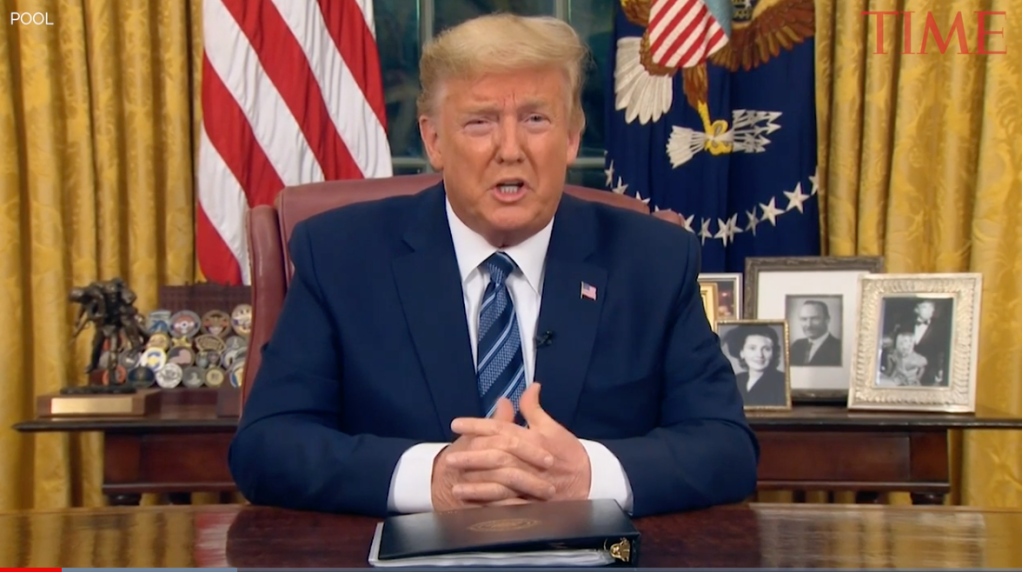
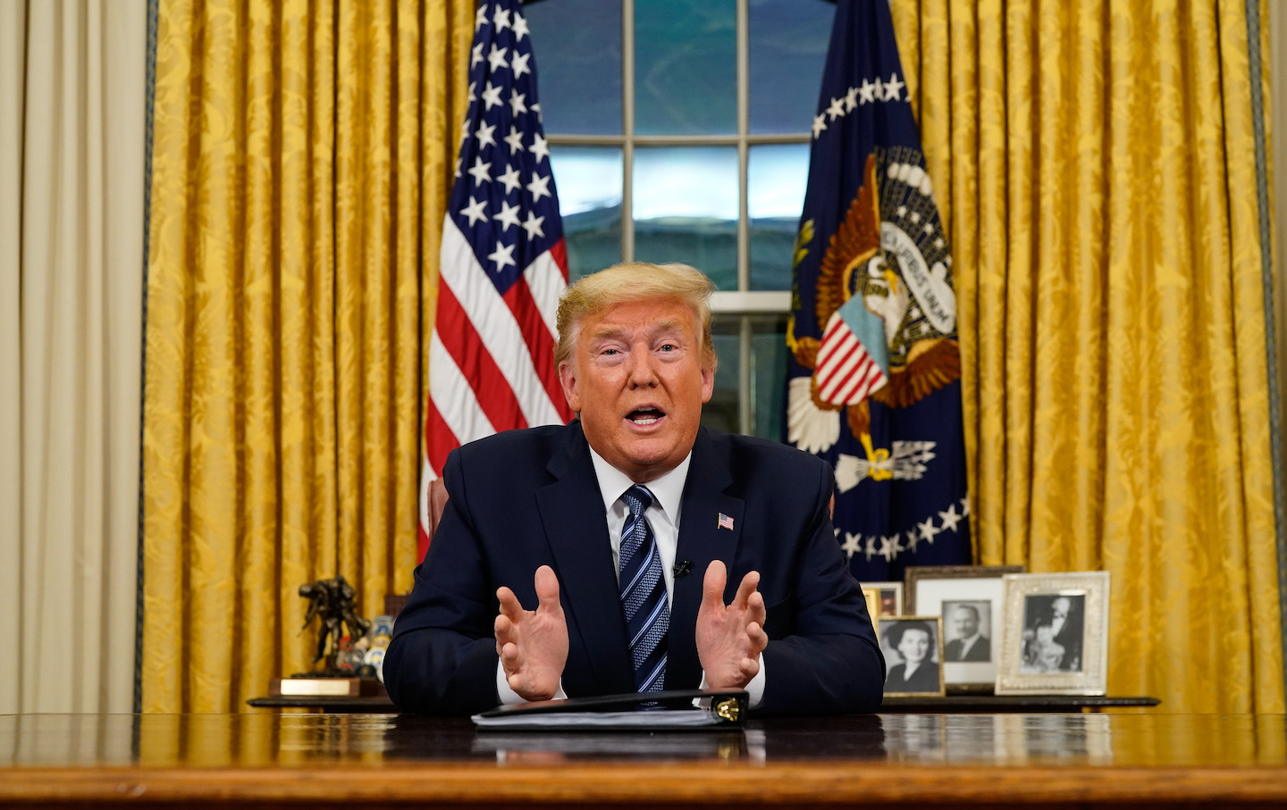

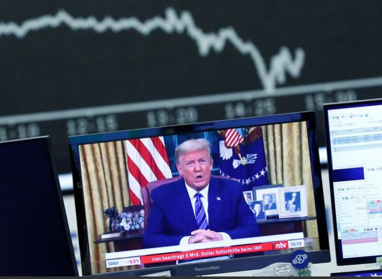
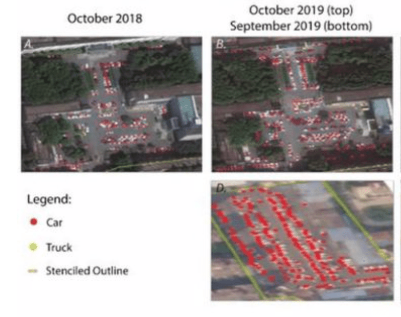
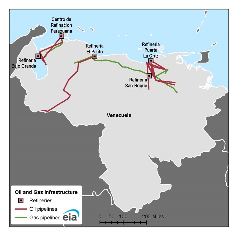
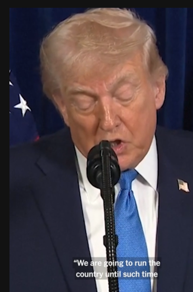

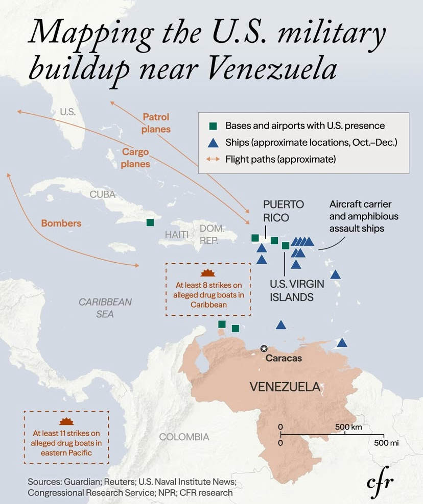
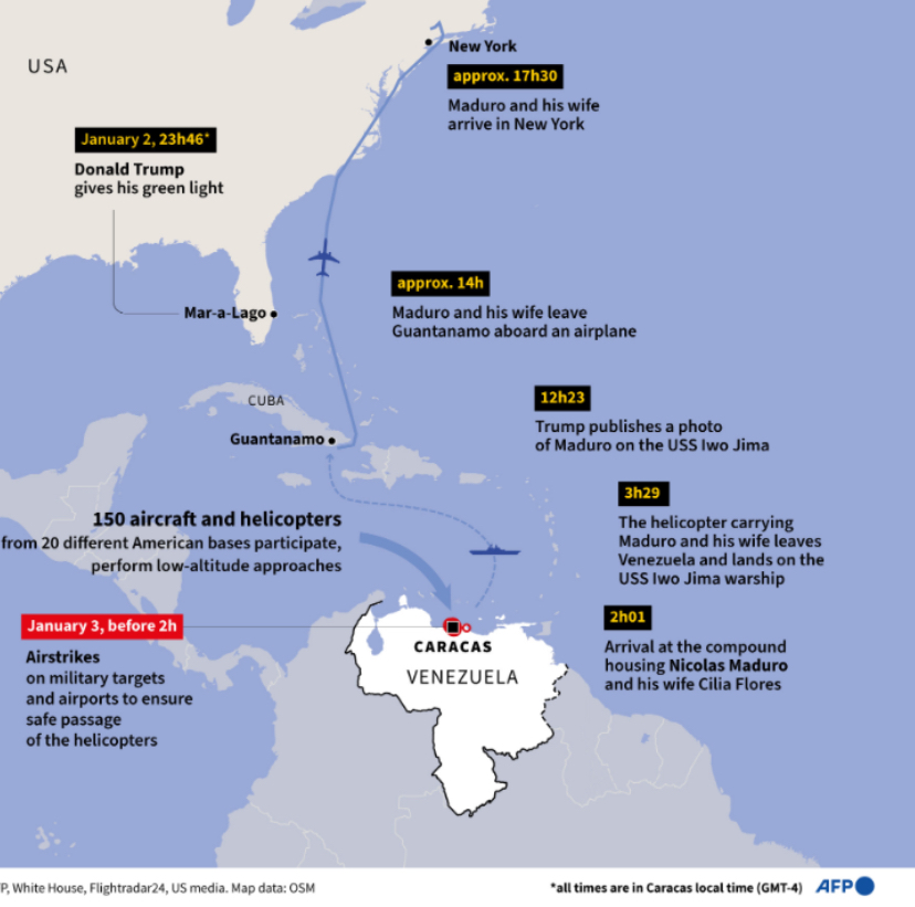
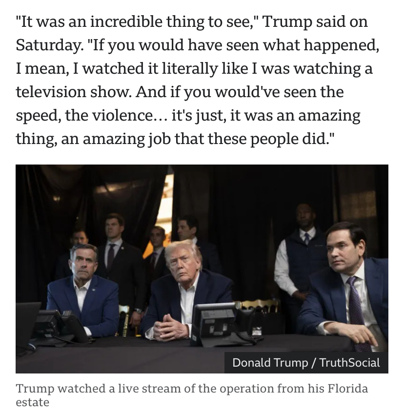
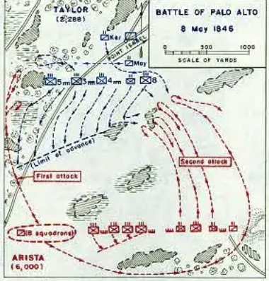

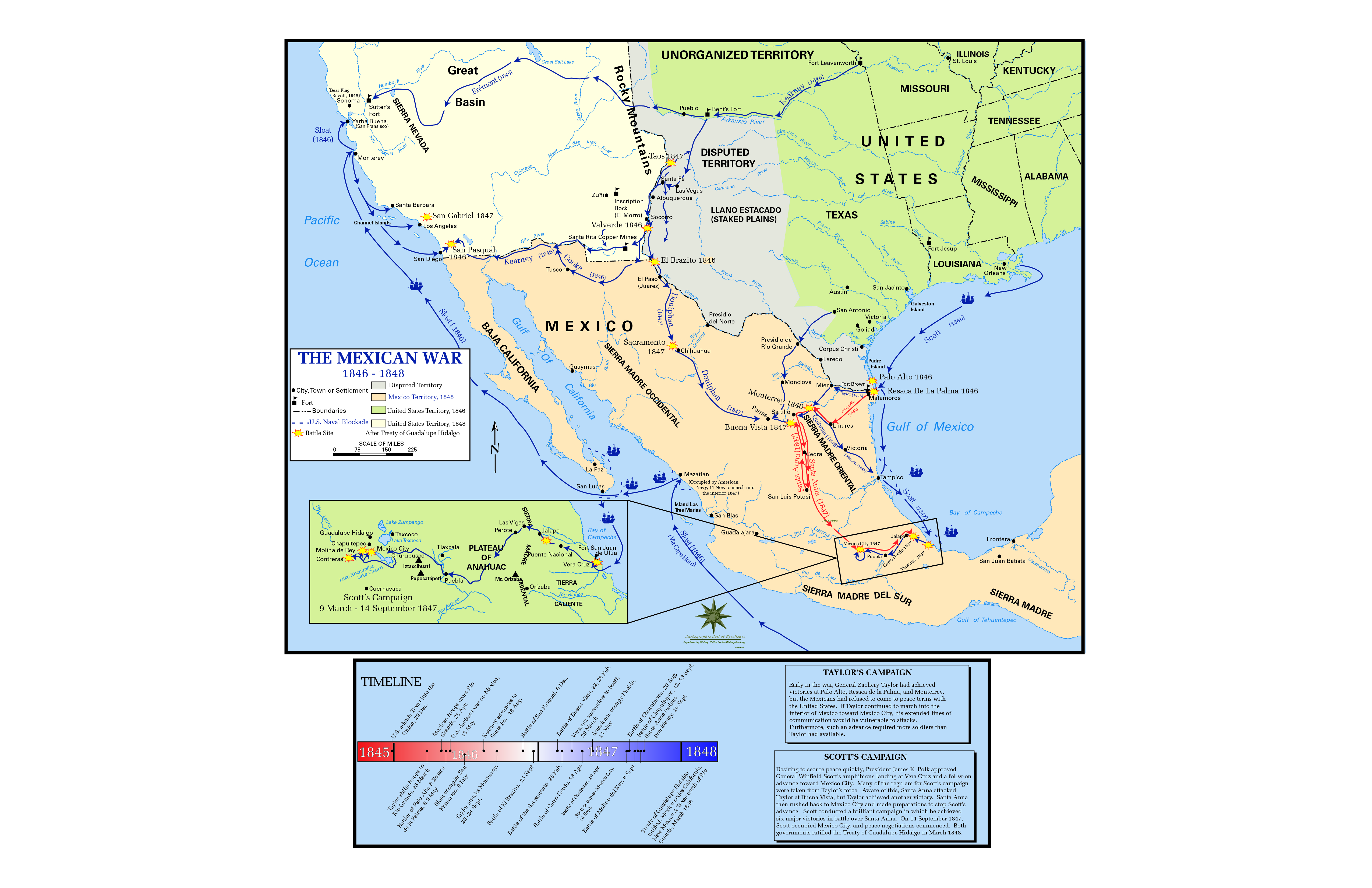

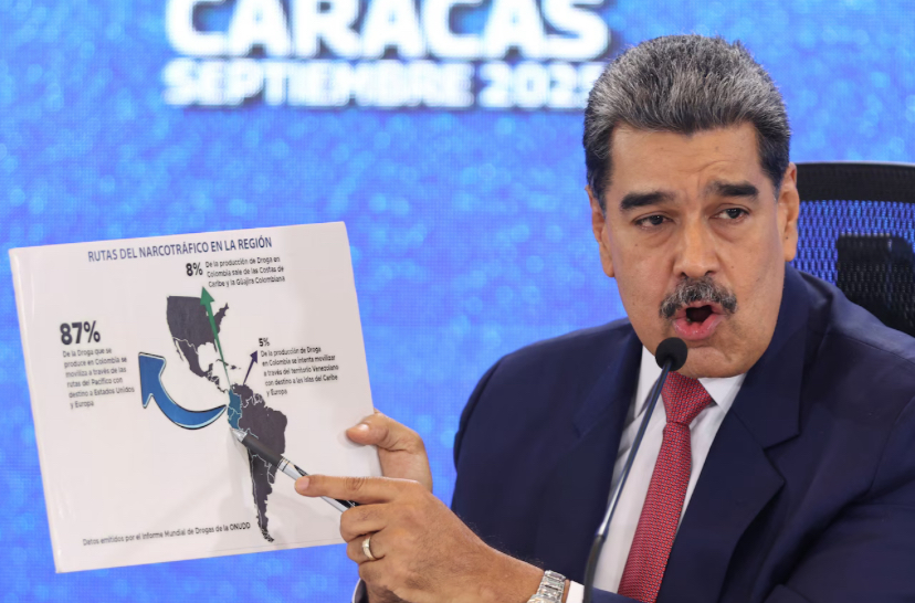
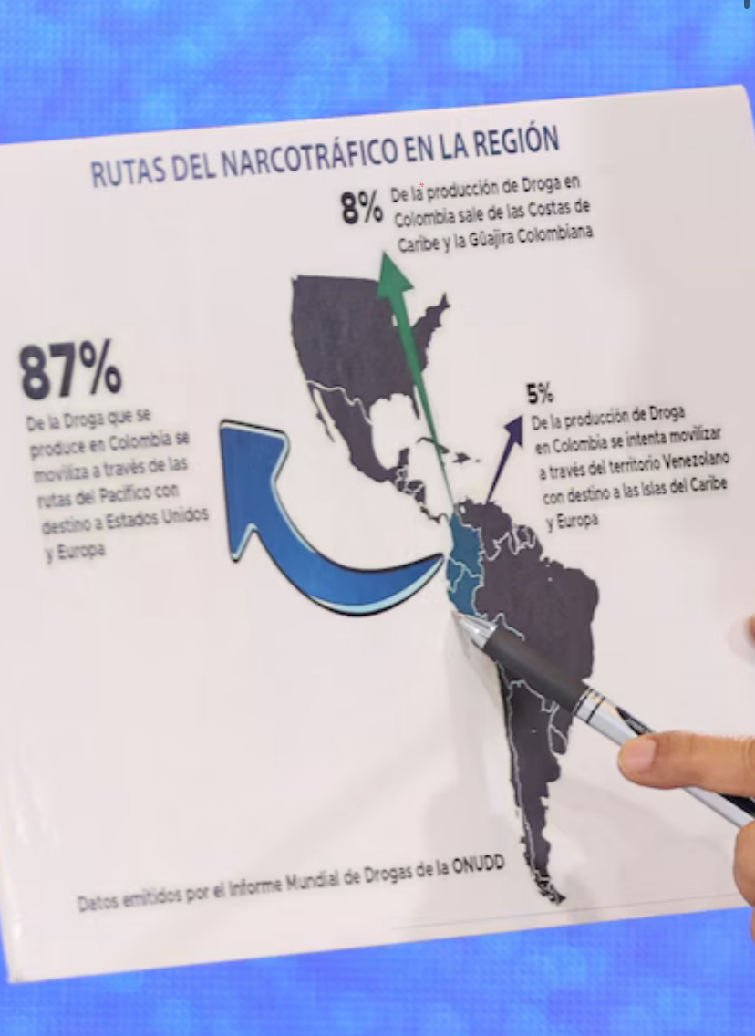
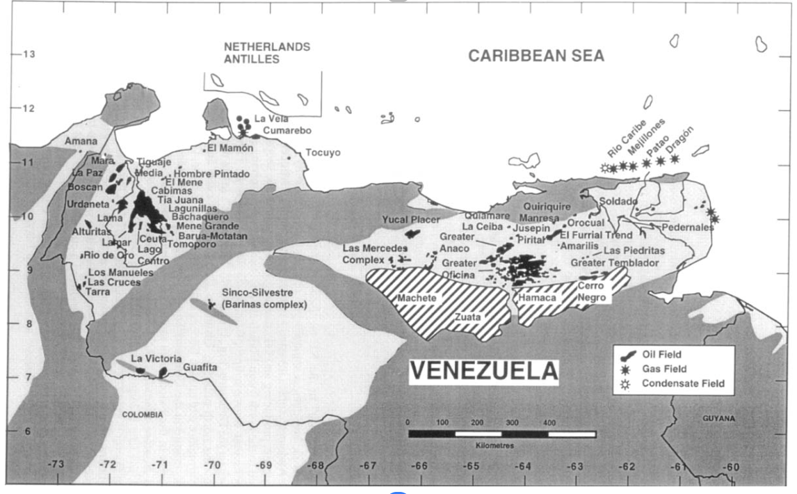
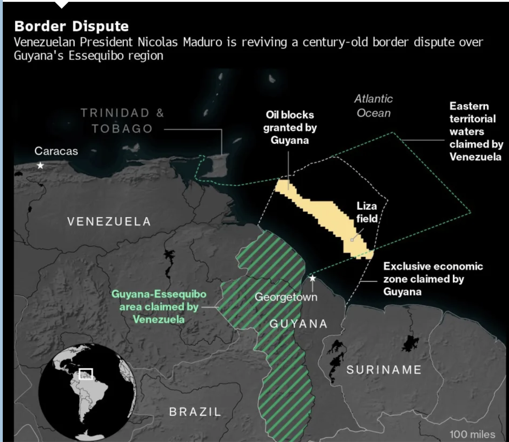
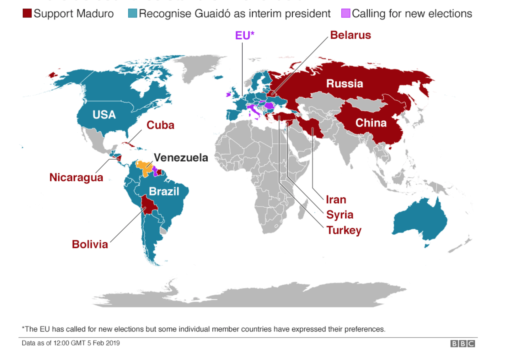
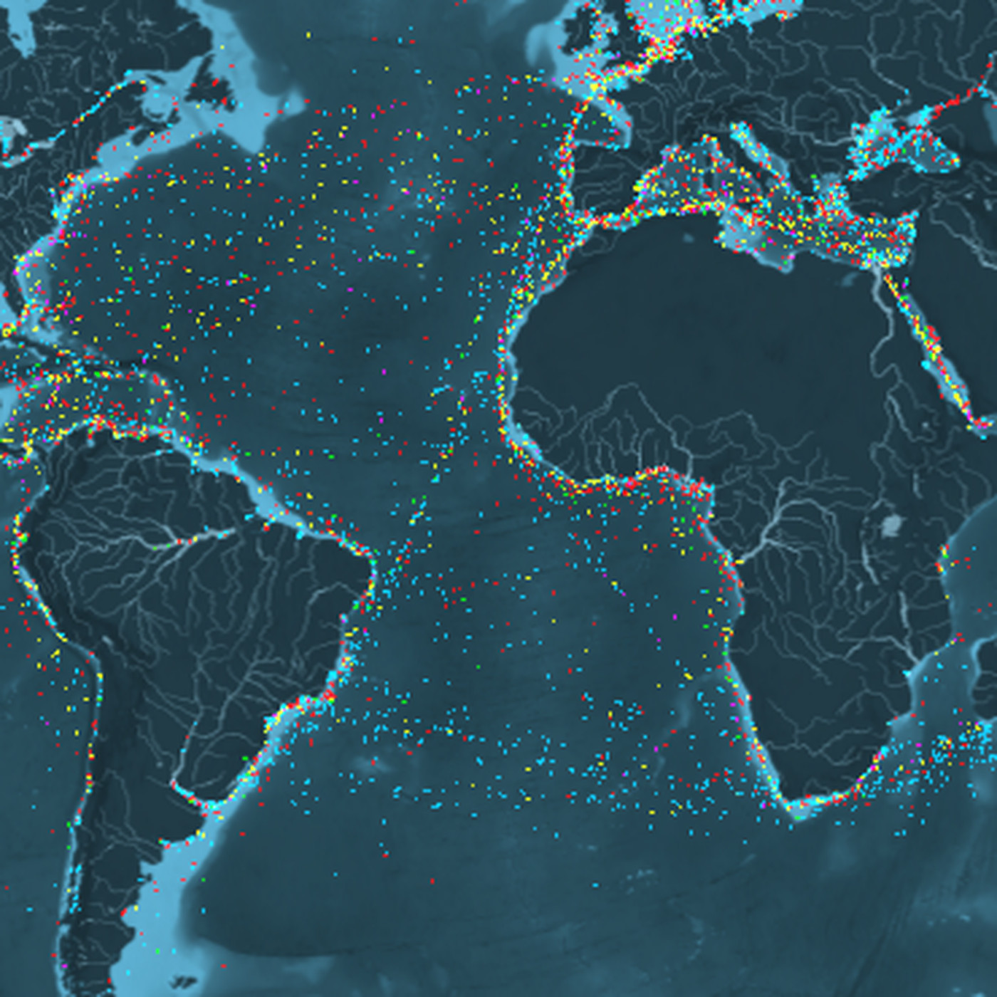

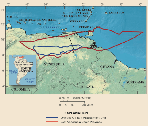
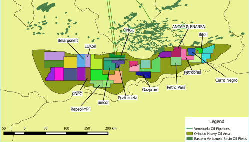
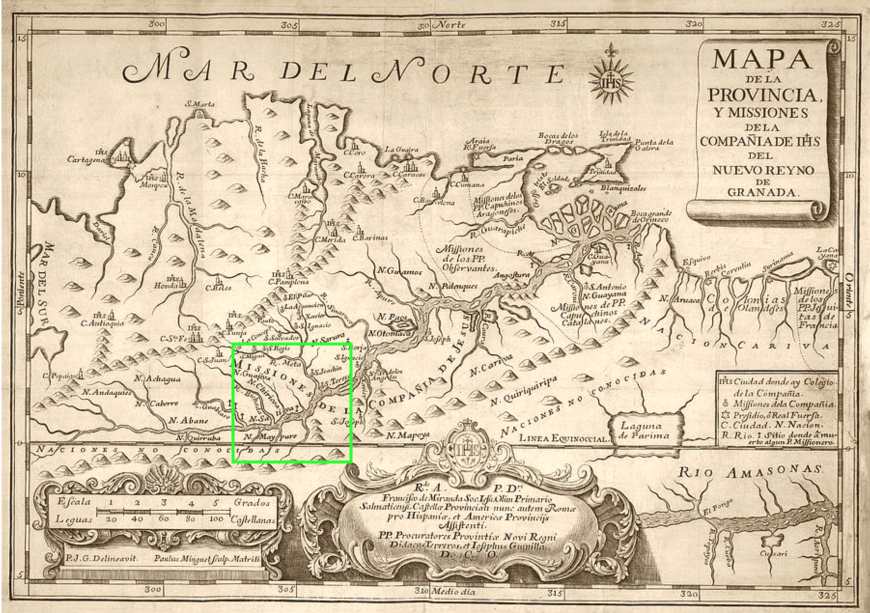
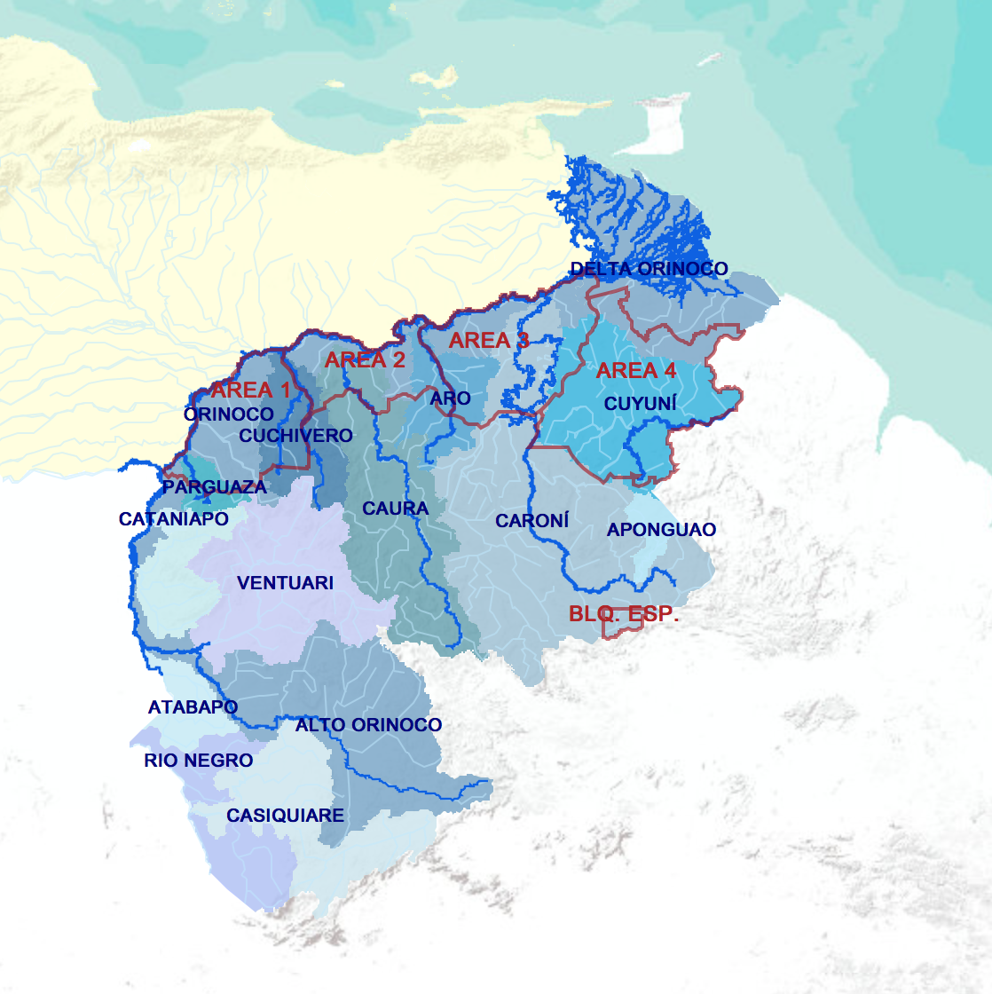
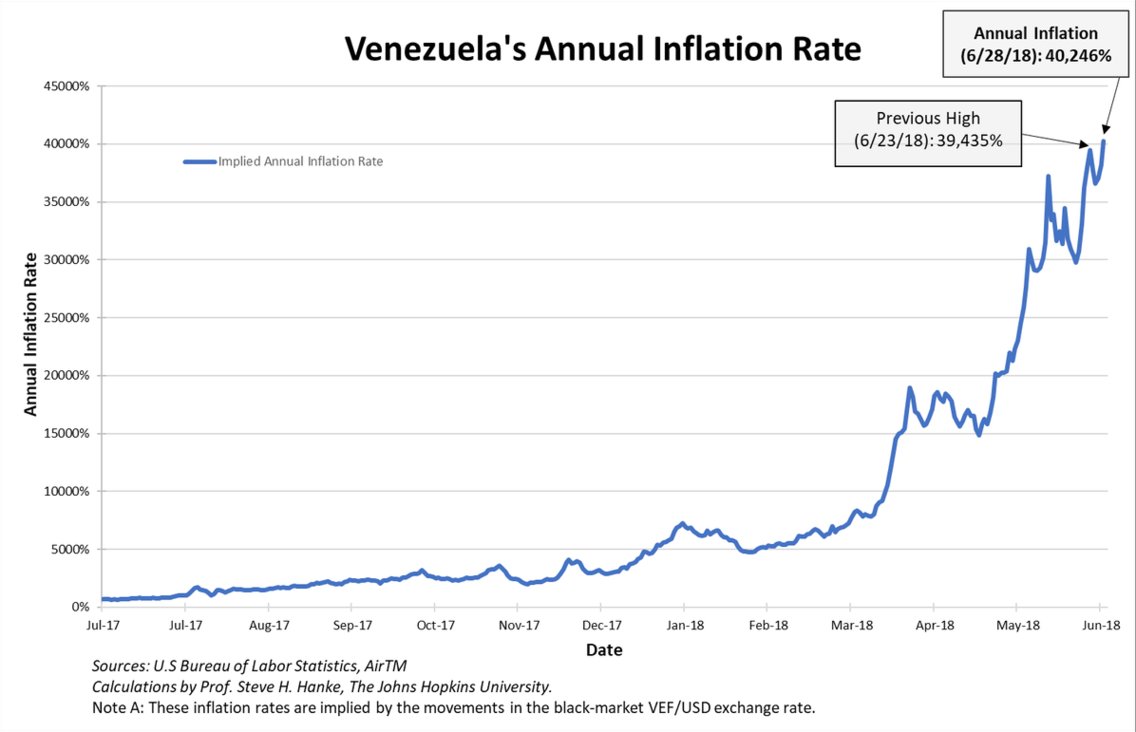
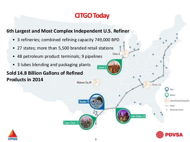
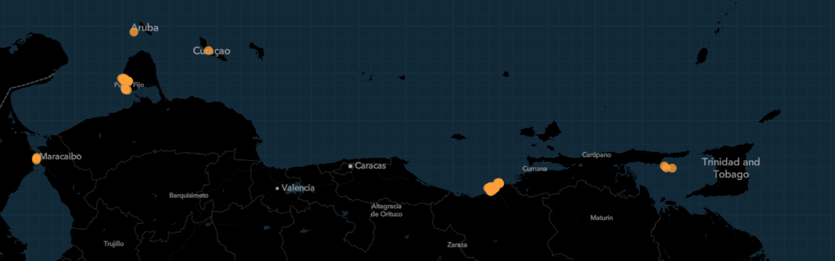
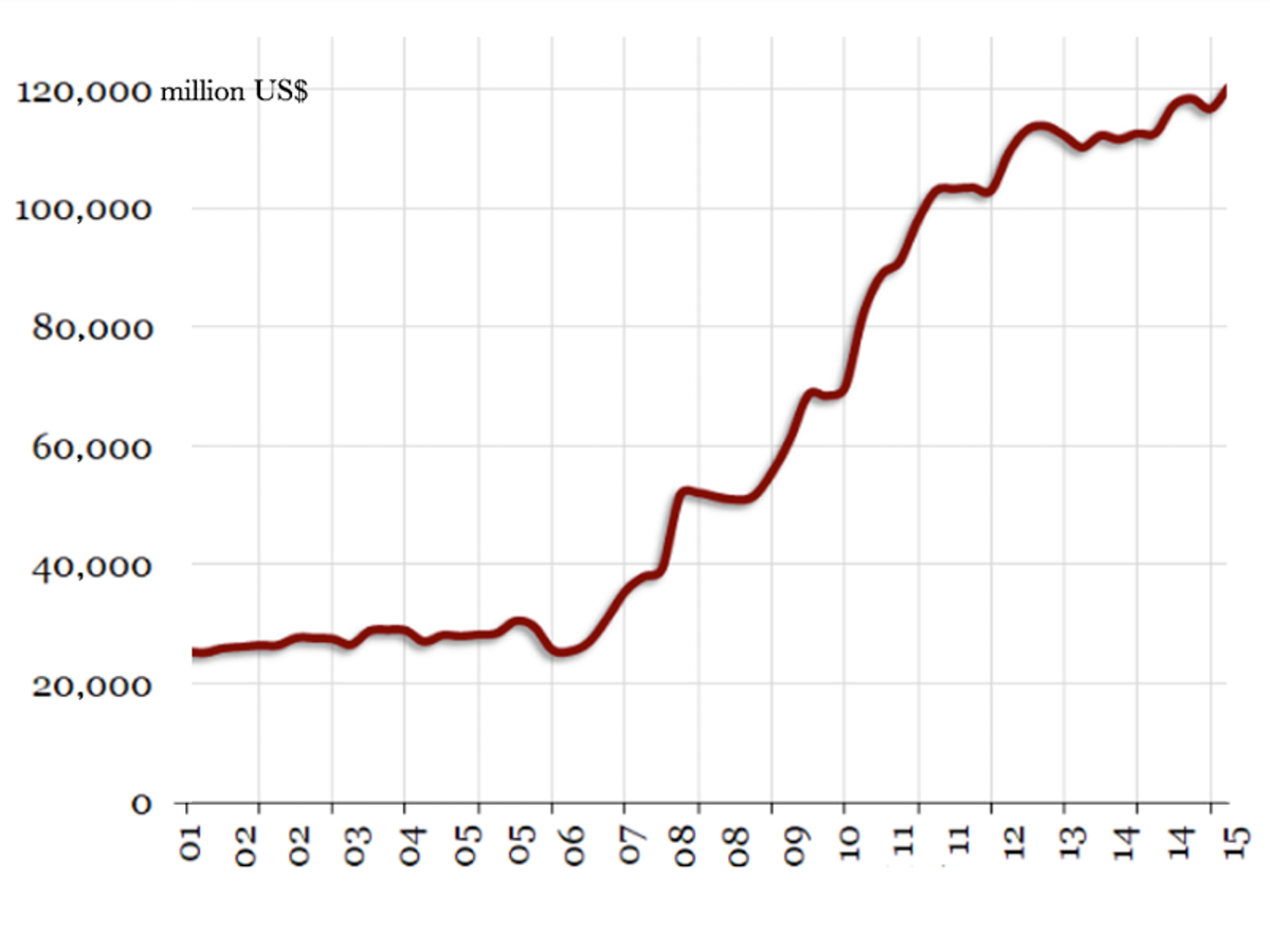
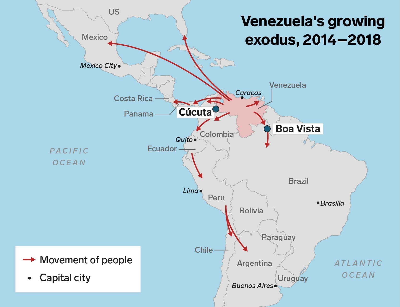
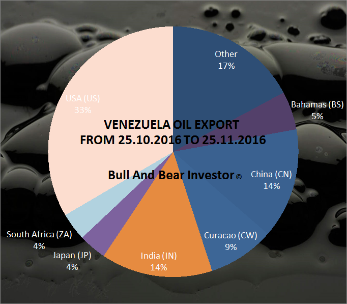
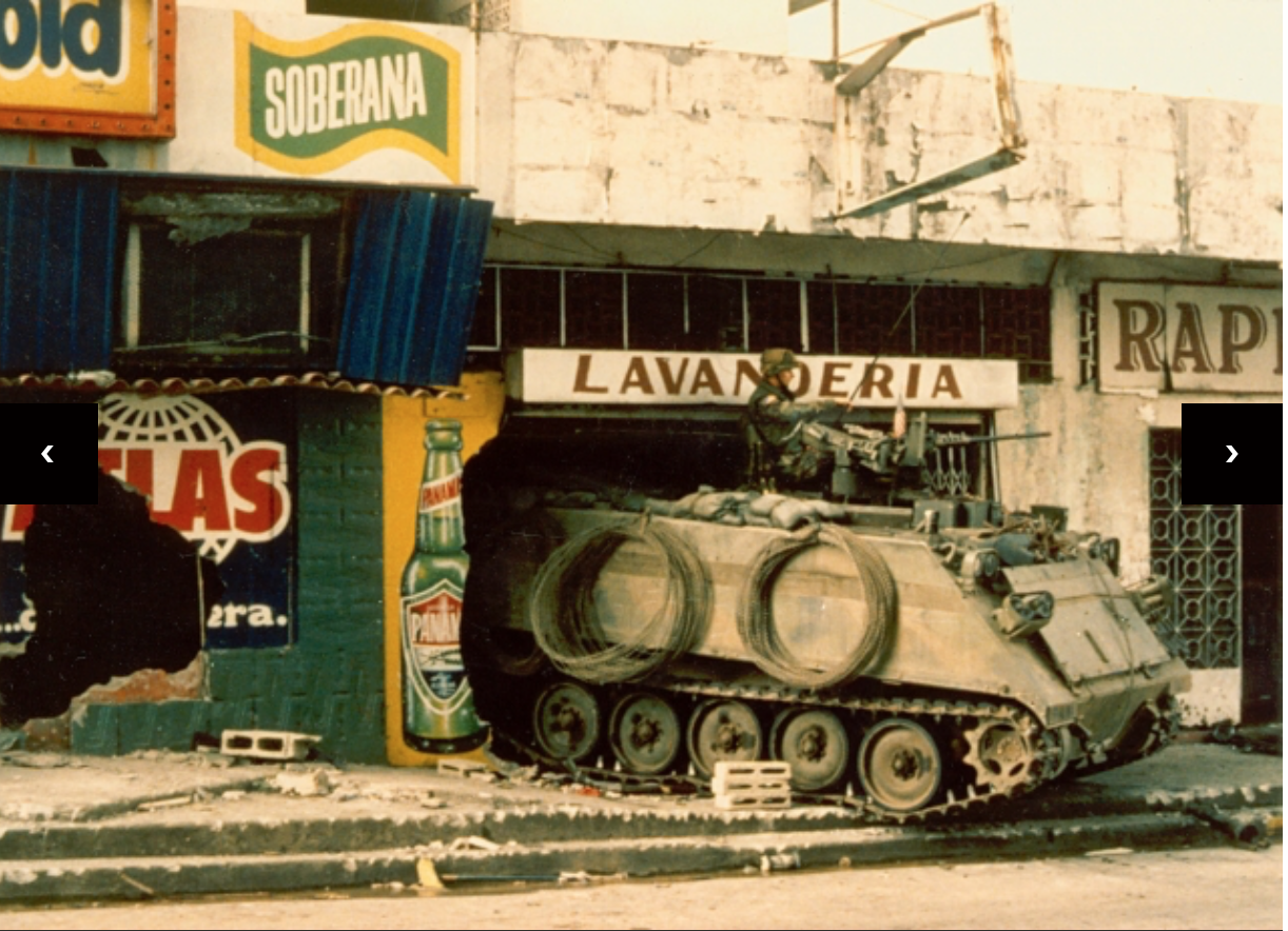


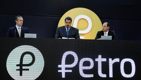
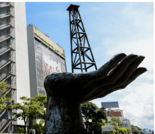

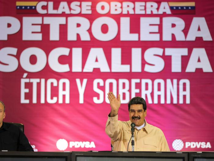


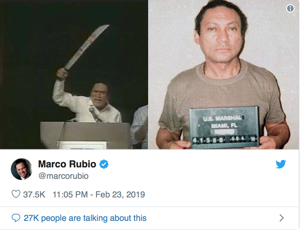

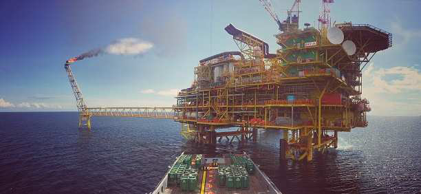

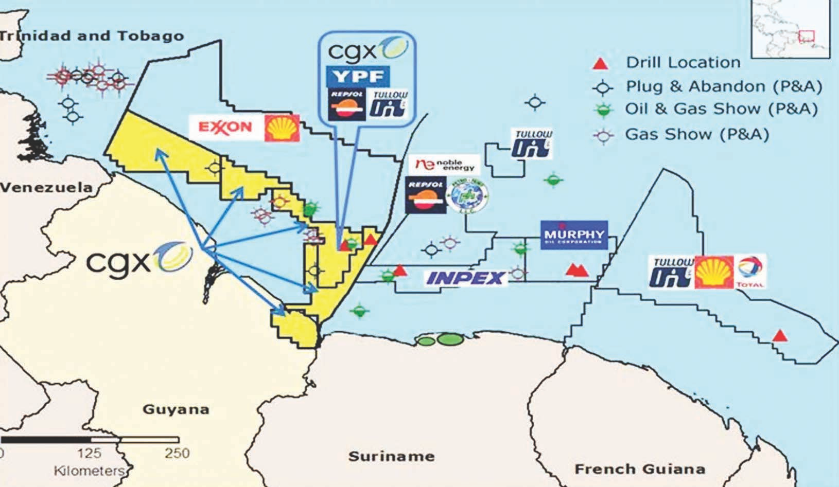
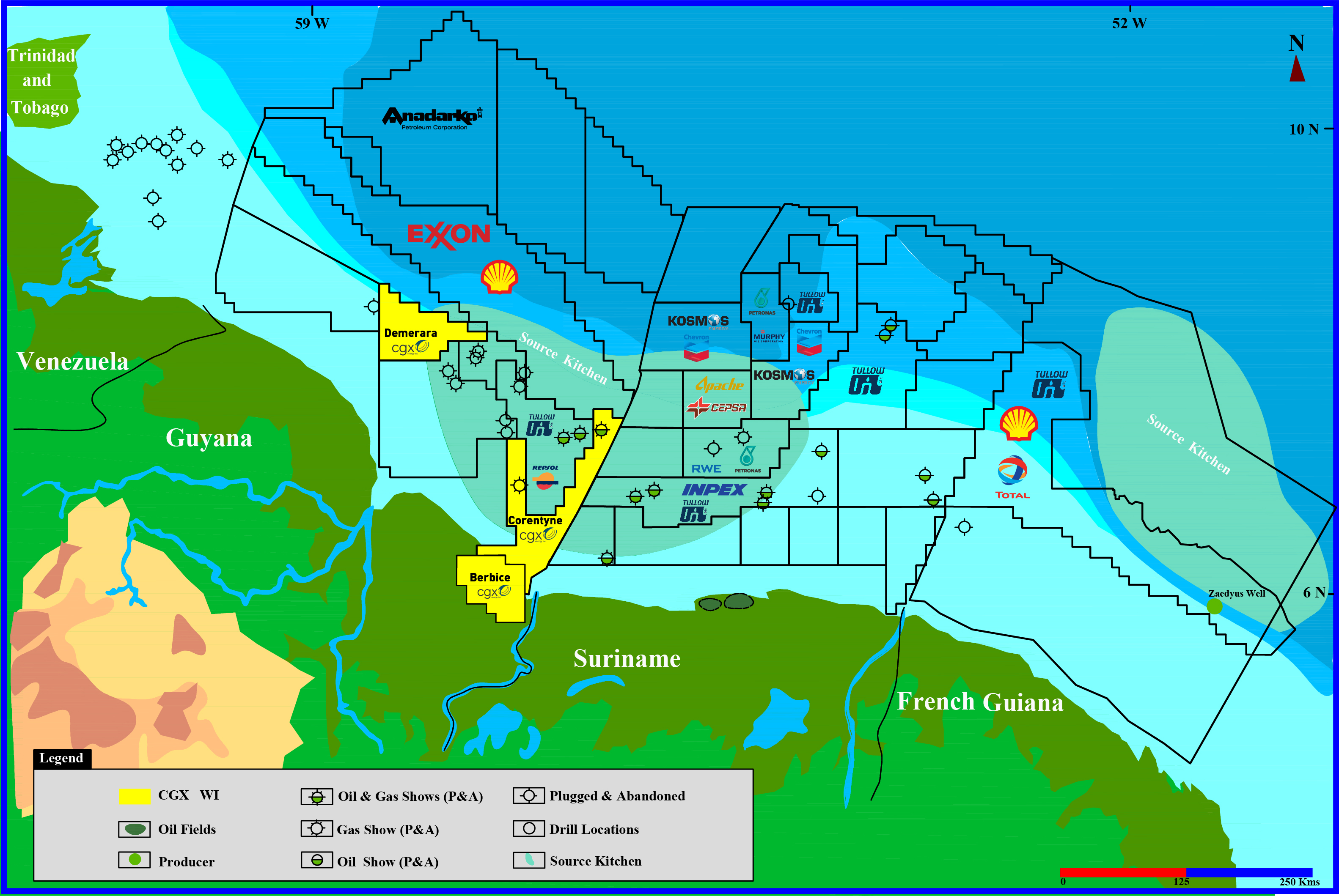
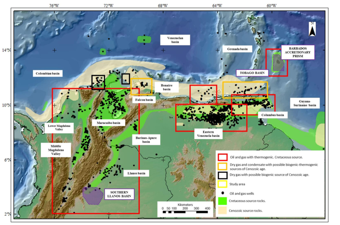

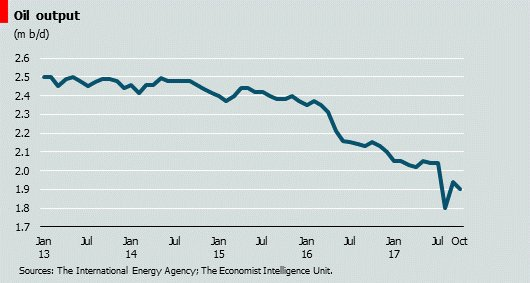

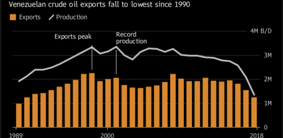
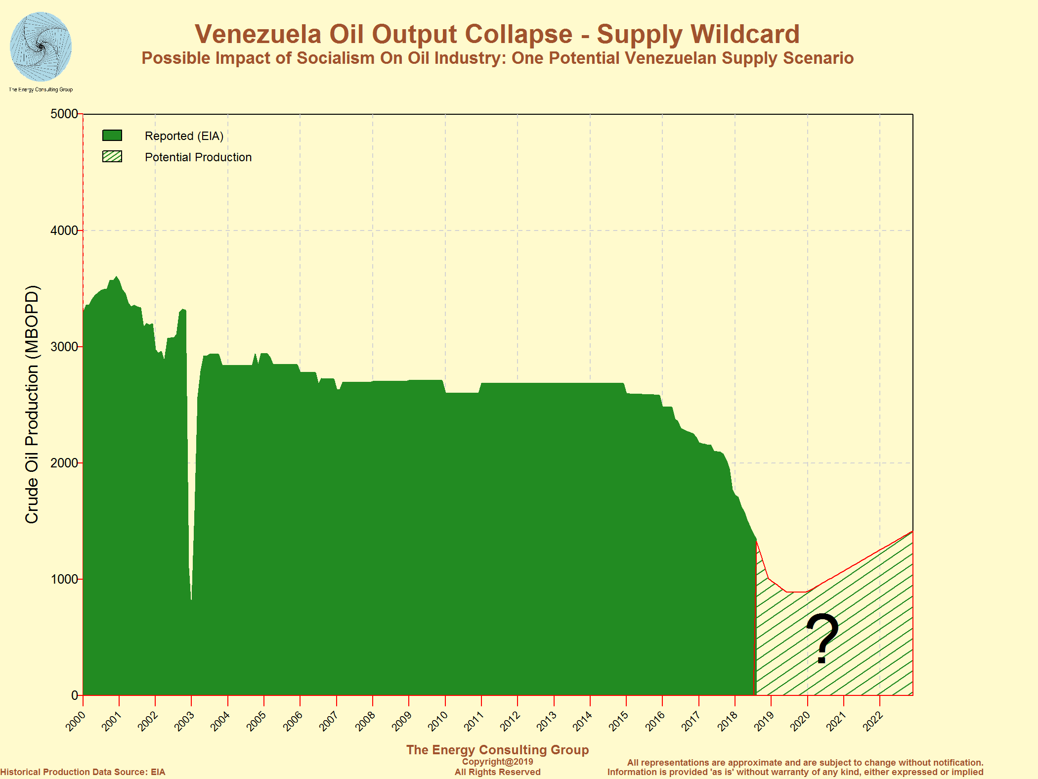
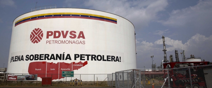
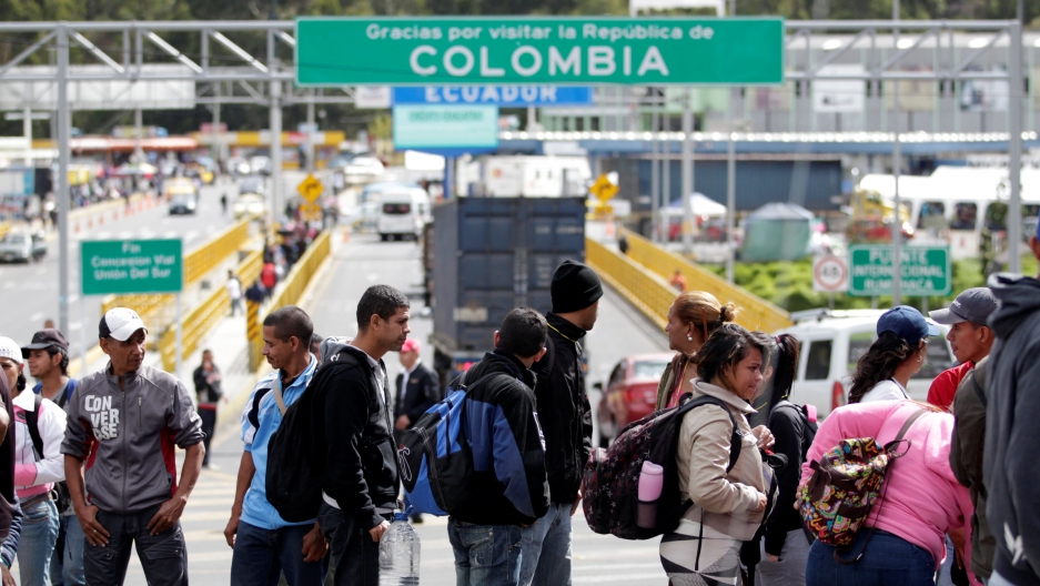
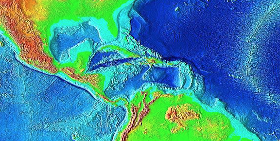
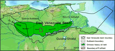
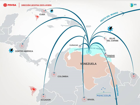
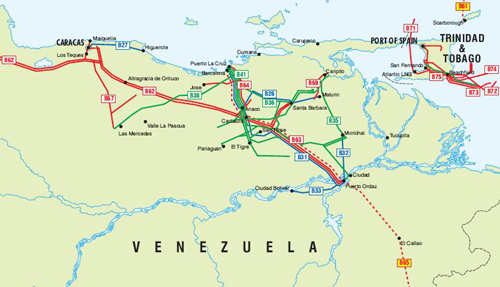
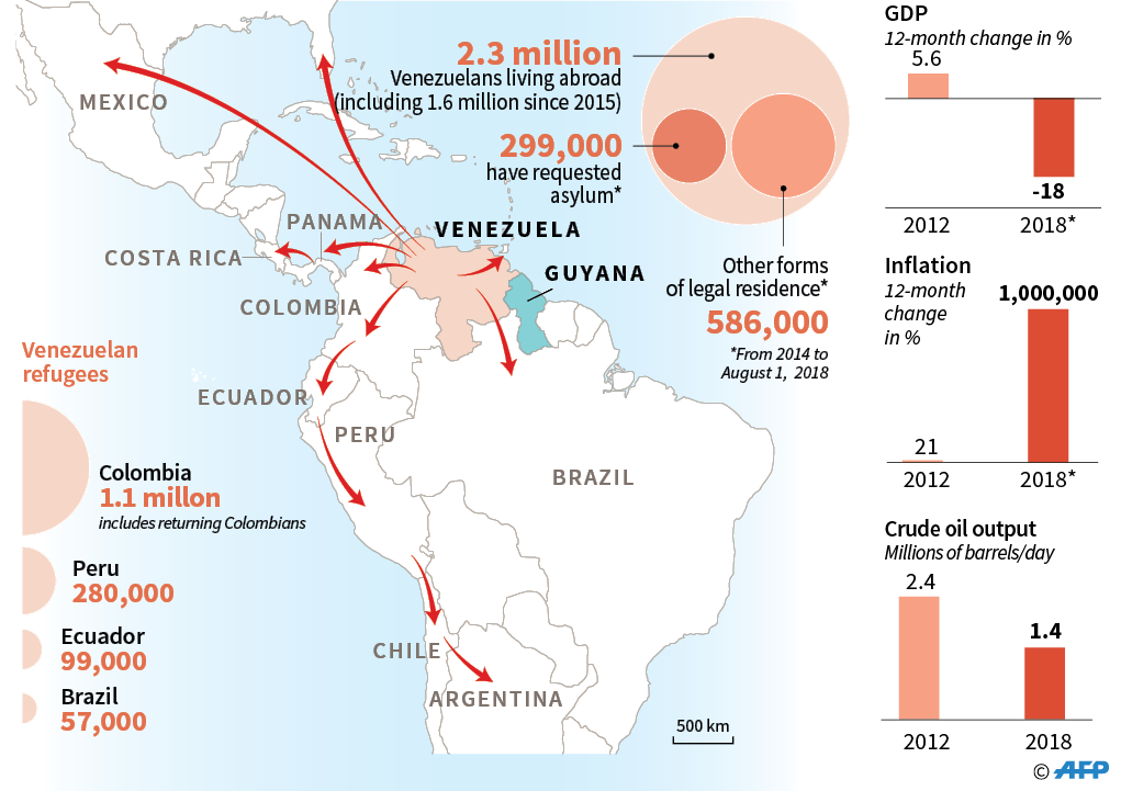
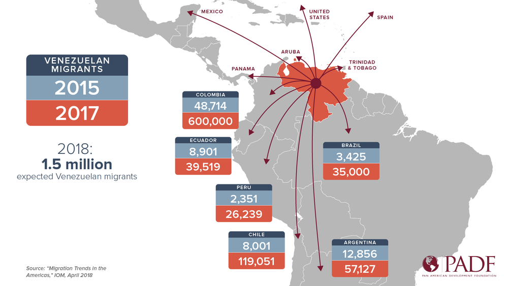

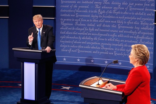
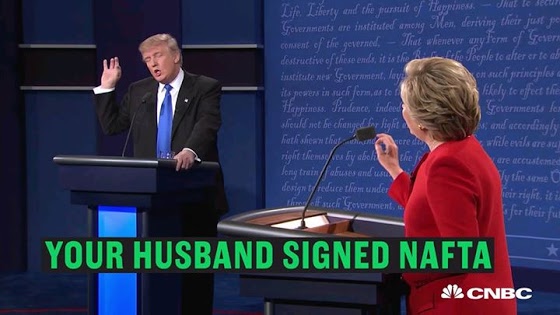
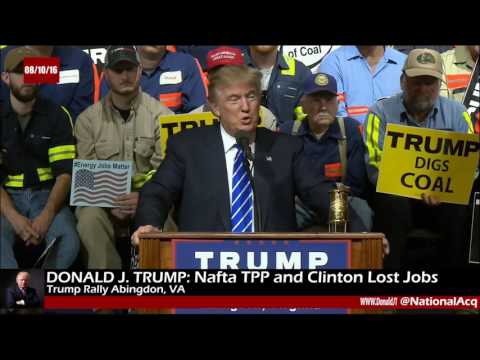
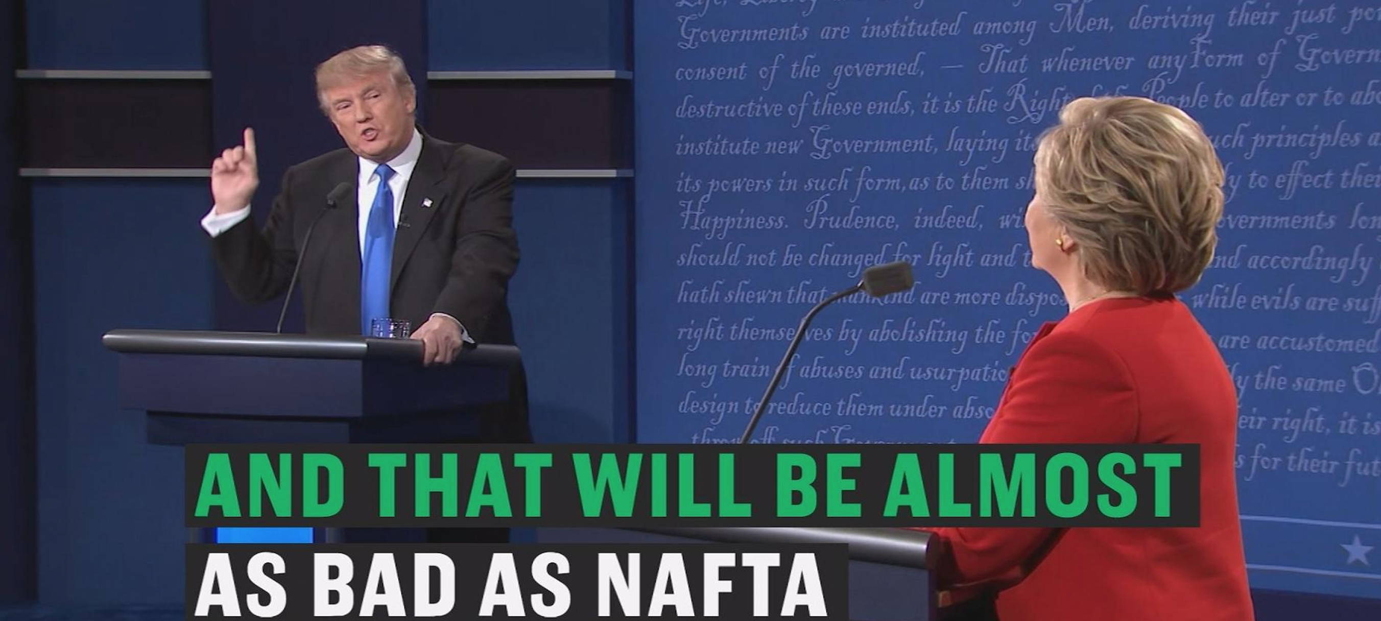
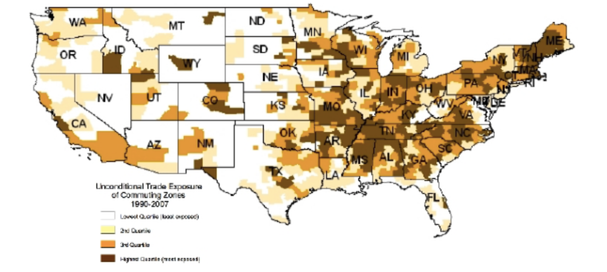
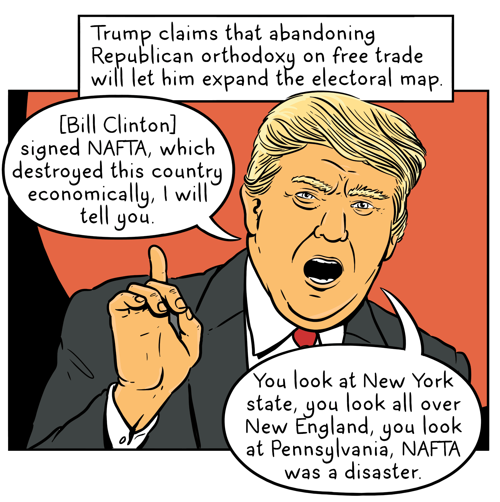
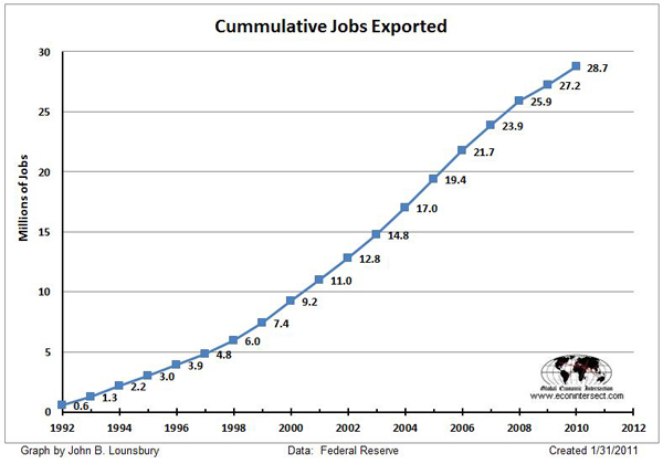
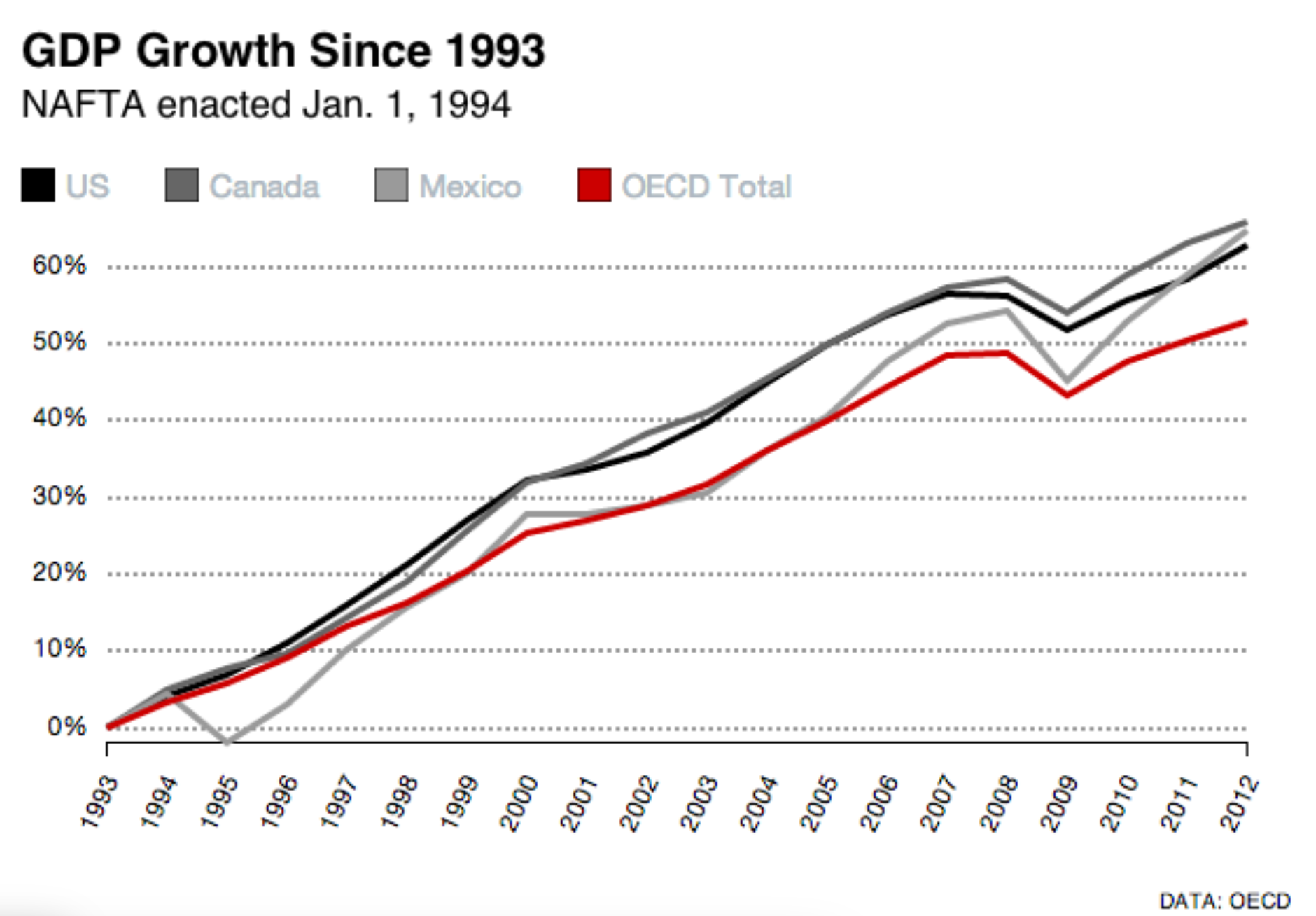
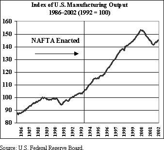

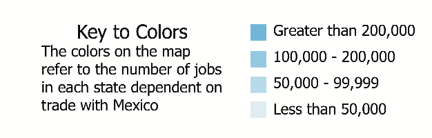
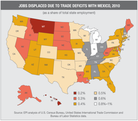

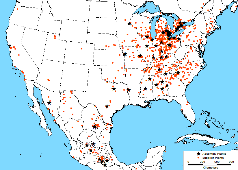
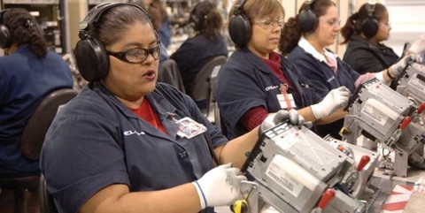
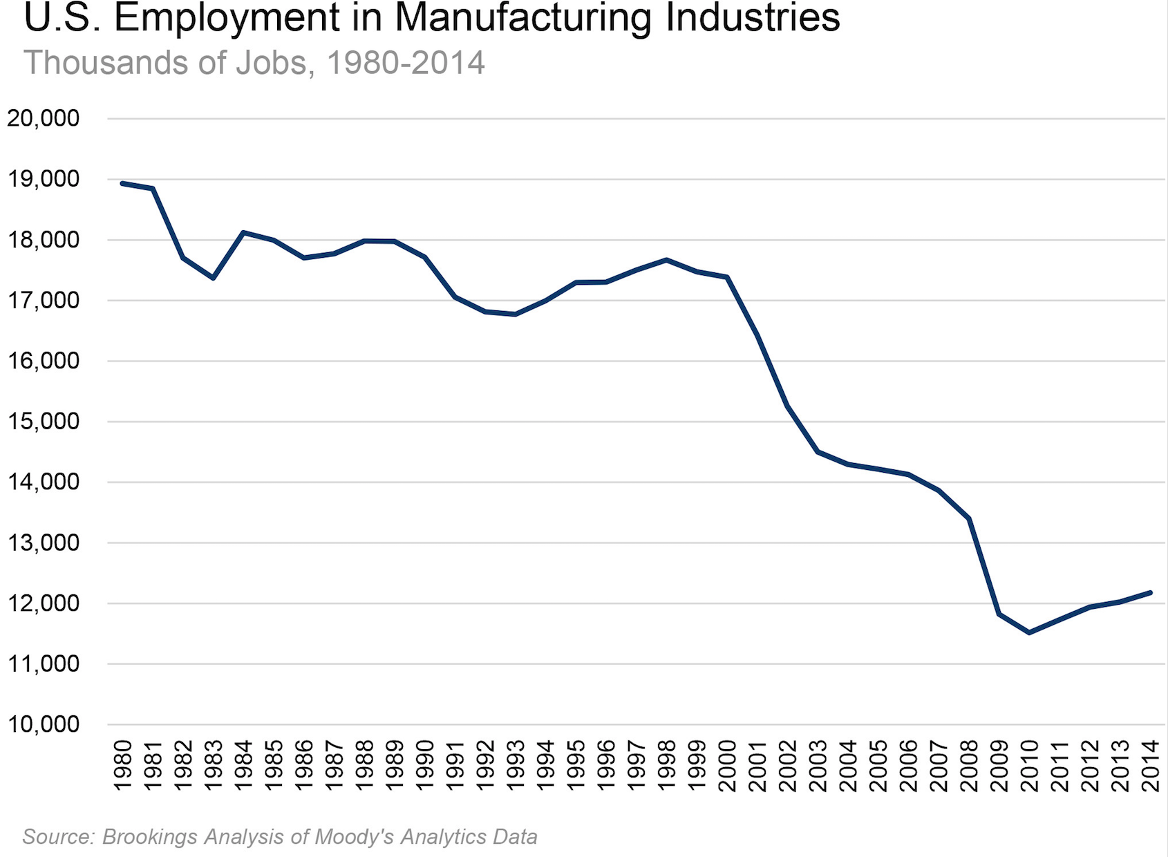
 Donald J. Trump for President Ad, “
 Patrick Corrigan, Toronto Star (10/28/2009)
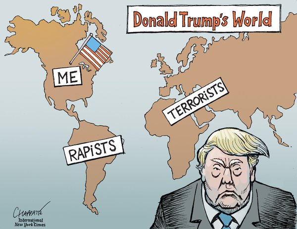
 Donald J. Trump for President Ad, “
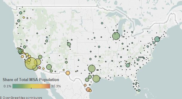
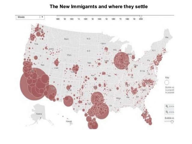
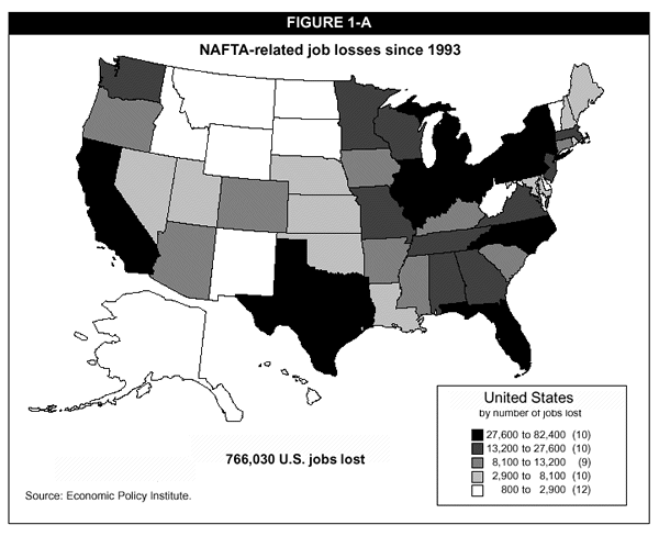
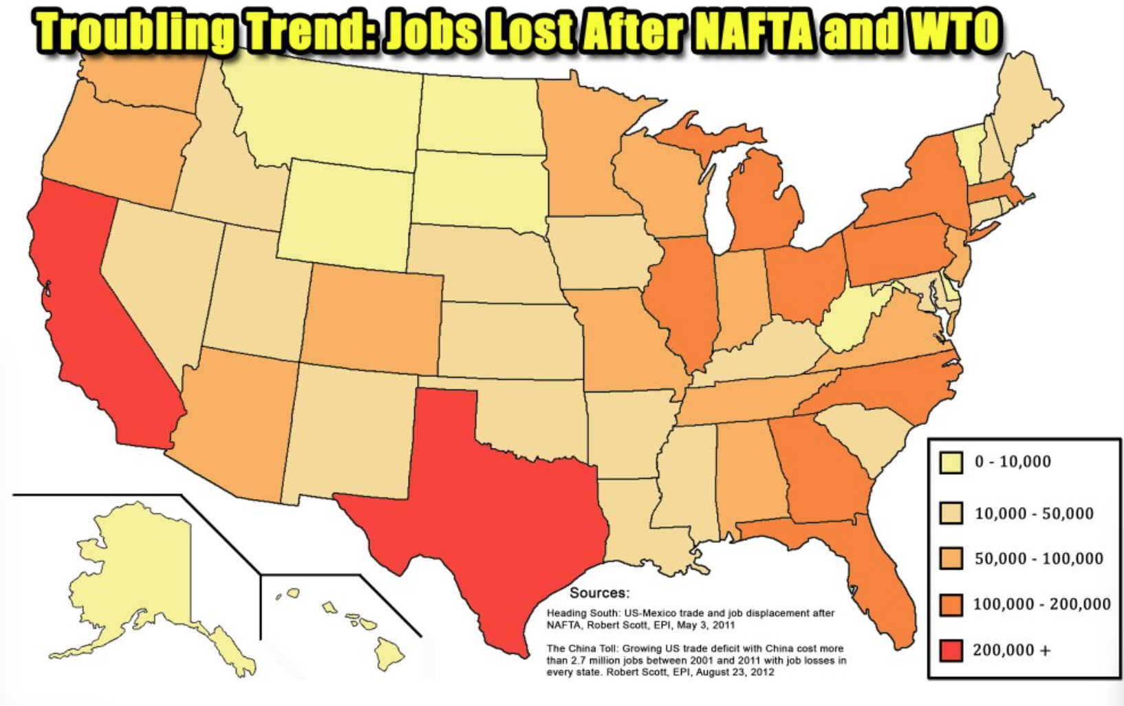
 US-Canada Border Slash/Google Map Data © 2016–Creative Commons
 Carolyn Cuskey/Creative Commons
 June 2006 NASCO website image of I-35 Corridor

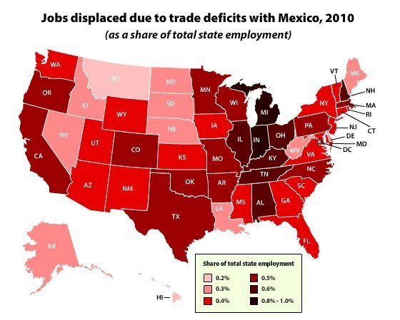
 Melanie Taub,
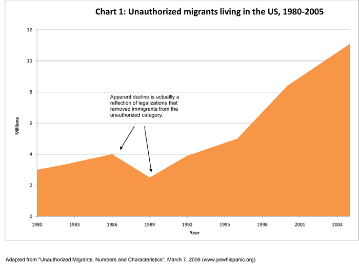
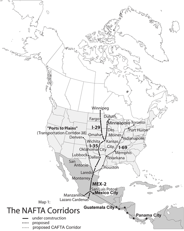


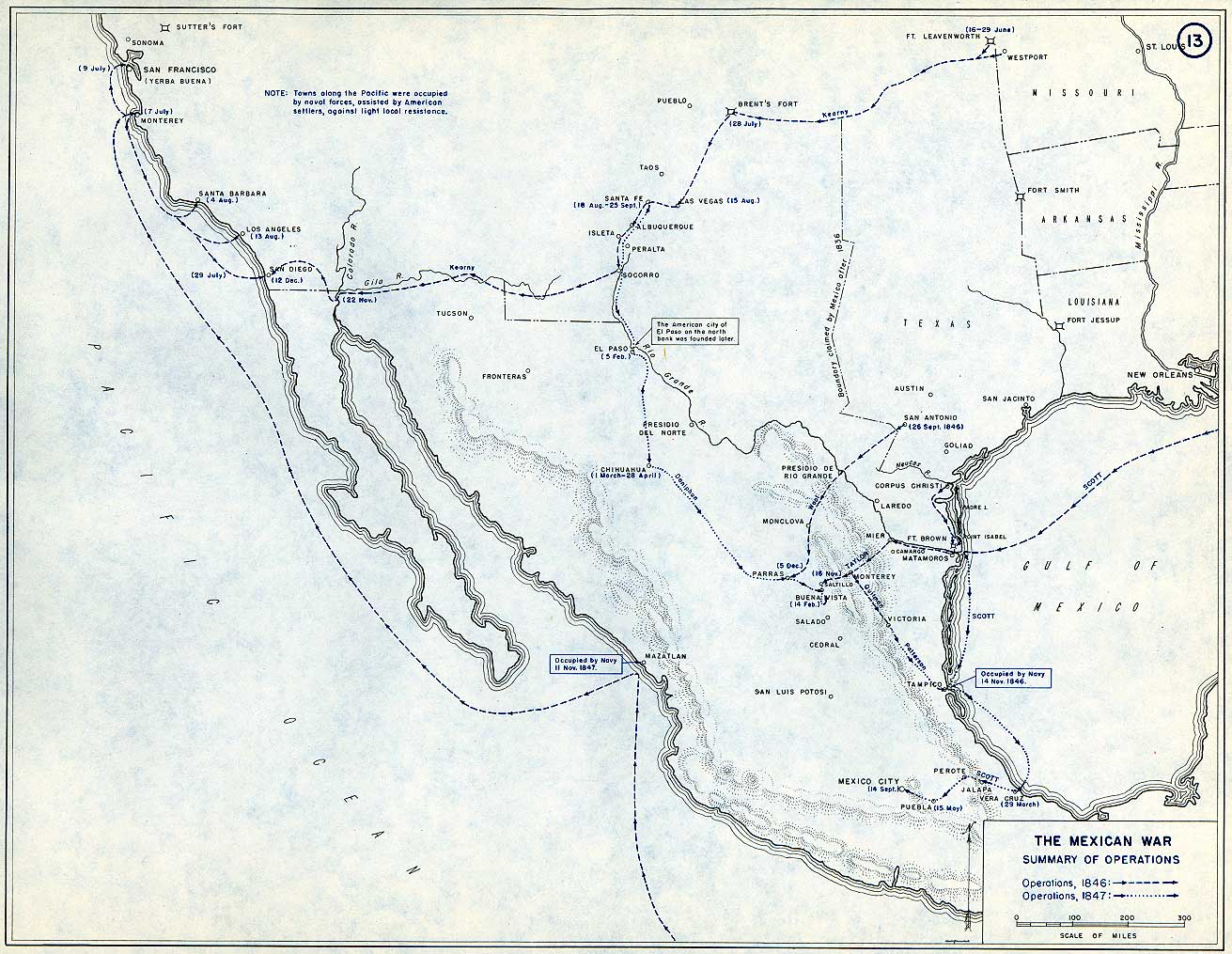