
We have learned to expect to pause as Google Maps draw boundary lines, extending to new tiles which soon take forms bounded by in clearcut lines across uniformly flatly colored quite static blocks, as data streams materialize forms from blurs that delineate highways, city blocks, state boundaries, and mountains in gray, green, tan, or light blue–a poor surrogate reality that strongly contrasts to the vivid ways we experience space in early modern maps and globes.
The convincing nature of the watery globe was far more pronounced in an era when the ocean provided the only medium for global travel, to be sure, and the immediacy of rendering oceanic space far more of a concern of global mapmaking. (Indeed, for a more extensive consideration of map authorship and the concerns of its representation of oceans, see my post on its mapping of ocean waters.) The medium of the woodcut presented unique challenges of mapping the circumambient oceans, not defined by clear routes or itineraries, but as a unique medium of travel. The curving lines that lapped the shores of inhabited lands in an early map of northern Europe, reprinted as the endpaper to a universal history, the Liber chronicarum, ad derived from a map of northern Europe before the “discovery” of the New World, that set places and regions in northern Europe apart from a wavy sea–
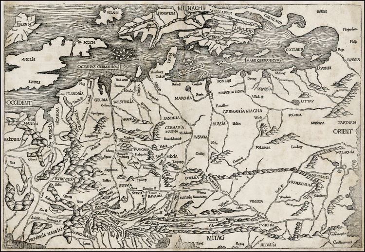
The northern seas are denoted by individual lines echo a global bifold map the same 1491 Liber Chronicarum, just predating the discovery of the New World, a detail of a crudely engraved world map in which one sees swirling waters that encircle the island of England and indeed all of Europe–and make one think of the difficulties of reconciling and bridging different registers of mapping land and sea for readers in the late fifteenth century.

Unlike the on-screen conjuring of a demarcated space, the design of early modern maps invites detailed examination. This undated miniature globe, engraved with considerable care on a two conjoined halves of two ostrich eggs, the size of a grapefruit, invites viewers to sail on the seas that swirl around a record global totality as something like a surrogate for actual world travel, its carefully worked details leave a clear trace of the hand, if not betraying the new phenomenological properties of the surface of engraved maps.
Although maps are often though of as paper constructions, the new properties of synthesizing land and sea in Ptolemaic maps are quite similarly approached in the very unique surface of this strikingly tactile engraved map–joining rounded halves of ostrich eggs–

–invites a distinctive attention to similar circumambient waters, which flow about the continents on whose surface we can see clearly engraved and legible toponyms: the seas are far more murky, as if they land had been the only legible area that was raised from their depth. The raised nature of the terrestrial surfaces on this globe–where the oceans are literally scratched away form its surface, as are the chains of mountains, coastlines, capital letters indicating terrestrial regions, and limited toponymy, suggest a marvel as much as a terrestrial map, and remind us of the interlinked discourses of maps and marvels, and the collection of curios as vehicles and mediums of geographic knowledge.
The engraving of a newly imagined expanse reported in marine charts created quite distinct operations of visualizing a newly materialized space–it displays one of the first maps to be printed that showed the New World’s form and recalls the earliest printed images of North America. The islands of “Spagnola [Hispaniola]” and “Isabella”, barely balanced with the huge area that it assigns to the Land of Brazil, or “Terra Sanctae Crucis” in something like an antipodal balancing act of continents around the equator, opposed in counterpoint to the Eurasian expanse. The coverage of the watery surface in the globe–which is in fact mostly covered by water–is even more pronounced in this apparently unique globe, composed of joined shell-like structures, treating the durable surface of the shell to create a luxury globe, which cannot, in its own way, but recall the famous apocryphal story of Christopher Columbus displaying the invention that was widely associated with cartographic modes for displaying the New World in flat maps, by challenging “lay a wager with any of you, that you will not make this egg stand up as I will, naked and without anything at all,” related in Girolamo Benzoni’s 1565 Historia del Mondo Nuovo [History of the New World], to compare the achievement of his discovery of the New World from “great men clever in cosmography and literature,” by the act of forcing the egg to stand on a table by allowing one end to be placed on a table as a support.
The eggshell map has no broken ends, but in its newly discovered form indeed stands on a table, allowing the observer to view to ponder the entire spherical surface of a globe, engraved on two ends of an ostrich eggshell, perhaps originating from a princely zoo, that lent itself to offer an exotic surface of cartographic demonstration to its privileged owners, quite unlike the manuscript or printed maps that are associated with early maps o the New World in the materiality with which it suggests the long voyage across oceanic expanse to reach a geographically enlarged (and now clearly out of scale) image of the New World islands, north of a creative rendition of a newly discovered South American coast, identified as the Terra Sancta Crucis, as if to retain the Christian eschatology even in the revelation of a world whose form seems foreign to whatever geographic knowledge is revealed in the Bible: the new islands of Isabel and Spagnuola are themselves court creations of Columbus’ royal patrons, and inscribe claims to sovereignty to these new lands, but the invention of the ostrich globe, recently discovered over four centuries after the discovery of the Americas,
Did the discovery of this inventive form of globe-making, unprecedented in the literature, link inventively, artifice, mapping and eggs that afforded a basis for Benzoni’s apocryphal claim?
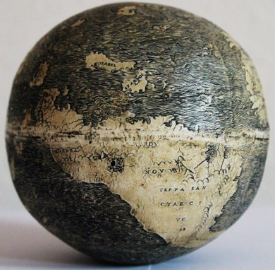
If the opposition of these continents in the ostrich-egg globe betrays significant cosmographical learning, the map itself reflects curiosity in the first mapped images of the New World, and a particular care to the definition of the coastlines of the newly found land masses we now call continents. The exquisite care and delicate relief of the globe’s surface in this delicate construction made from two ostrich eggs has been recently dated to 1504 by its shell-density, based on a CT-Scan. If the date can be ever established conclusively, the globe is one of the first images of the New World to have migrated from Portuguese marine charts to a particularly skilled level of craftsmanship, predating some of the known bronze globes of terrestrial expanse it resembles; the image of Europe, Asia, Africa and the Land of Brazil could be scanned in analogously crisp detail to known early sixteenth-century globes and printed map-gores. Indeed, the range of graphic tools engravers developed for embellishing the surface of maps set something of a standard for scanning land and sea, as their exquisite tones of shading increased the persuasive range of graphic forms that the anonymous artisan who made this eggshell map exploited to delineate the inhabited world.
Continue reading
