
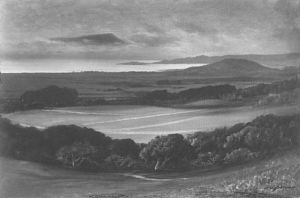
This rendering of the future site of a University in Berkeley by R. D. Yelland imitates the genre of a real estate ad and bucolic fantasy amidst rolling hills: after the foundation of great land-grant universities in the middle west, the painting suggests the existence of basic walkways and streets for the university that are framed by banks of local vegetation and trees. It is not a map of the area, but suggests a prospect of a future map of the region, rendering the vision of a spiritual site for education that inspired Samuel Hopkins Willey when he purchased the land “for the dream of a college.” It is a place that was not yet defined, but was ready to be mapped and settled as a seat of learning and formation.
(For more images of the site of the university and roads that bounded the area: http://www.sfgate.com/bayarea/article/Eccentrics-Heroes-and-Cutthroats-of-Old-Berkeley-2523725.php#ixzz2KScJDa30.)
The historical remove of this scene is striking, but a sort of agricultural archeology exists today in Oakland and the East Bay that has just begun to be mapped. This map of urban farms and farming,while of different cartographic form and far more based on actual statistics, suggests how from a number of school gardens in the Oakland Unified School District, at least seven “community gardens” can be identified in the region as well as some neighborhood farms. Rather than point to a project of ‘regreening’ Oakland, a city without much arable land–and more notorious than other cities in Northern California for large range of paved areas and highway routes–the map reveals not only renewed attention to urban farming, but a new attitude toward urban space that the expansion of urban gardens has directed attention. And the map suggests the future prospect for the city as an inhabitable space.
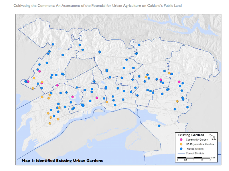
In the wake of farmers’ markets and the rise of Berkeley’s Edible Schoolyard project, the question of access to fresh vegetables and produce has become a social justice question in Oakland, as in the rest of the nation. Not only is there a conscious desire to restore active gardens and gardening to urban space, but a large educational role of the garden is evident in how with the help of the California Department of Education’s Garden in Every School program and the University of California Cooperative Extension‘s school garden program, in Oakland nearly 100 childhood development centers and elementary, middle, and high schools have active school gardens to teach science and nutrition. The network designated by blue dots in the above map of Nathan McClintock reveal an expanding network of city gardens, which may have laid seeds for the City of Oakland’s Community Garden Program, the gardens of City Slicker Farms and the People’s Grocery, and other programs focussing on rooftop gardens, gardening for kids, and urban urban gardening workshops or centers.
The expansion of these farms do more than try to restore the tie of urban space to local agriculture, or remind us of the farming lands that used to border cities up to the mid-twentieth century, and still border some towns as Madison WI. Despite the fact that few cows moo in Berkeley, the image of Berkeley as an agricultural region survives in Berkeley Farms, McClintock mapped the city’s gardens to assess the potential that exists for projects of urban agriculture in Oakland’s large number of public lands. To be sure, McClintock and his team see limited viability for a regreening project on a large scale in Oakland–not only is this less in need in a place where agricultural produce is available nearby, but the expense of repatriating and cleaning soils of many public lands, including the Alameda airstrip or the vast number of underground oil storage tanks near the harbor and old train lines (who can imagine urban homesteading near Livermore?). But as any urban map presents an image of the city, the shift suggests a deeper change in how the city is seen. And despite the hazards of old house paint, new models of “phytoremediation” use plants to leech metals from the soil, as intense addition of compost may immobilize existing hazardous levels of lead.
But the map draws attention to or adumbrates a shifting attitude to urban space that asks us to reconsider the nature of Oakland’s urban space. The smaller blue dots that designate school gardens and dot the landscape have in the past decade set the basis for a flourishing of smaller farming areas and several sizable community gardens, most built and cultivated to serve the communities where they exist; a recent push toward the local sourcing of agricultural produce in the city has given impetus to a broad, if focussed, rise of clusters of local farming, most prominently associated with City Slicker Farms. Although a large number of plots were zoned for heavy industry in Oakland and modern Emeryville, much of East Oakland is both available and ready for agricultural use. The goal of using local sources for food was embraced by the Oakland City Council in 2006, when it established the goal of 30 percent local sourcing, and the attention to the benefits of urban agriculture as a source for local jobs and growth encouraged subsequent creation of the Oakland Food Policy Council. (For more on the formation of Urban Agriculture movements in the city see http://www.foodfirst.org; McClintock’s study is a model of mapping of the viability of local food sources: http://www.oaklandfood.org/media/AA/AD/oaklandfood-org/downloads/27621/Cultivating_the_Commons_COMPLETE.pdf
McClintock’s map of the relative sizes of these farms reveals that despite the small numbers of urban farms of substantial size, the considerable number (and clustering) of farms above 5 acres in East Oakland in 45 ‘urban farms’ that have changed the landscape of the city in recent years.
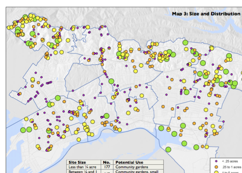
These farms could never meet Oakland’s demand for greens, despite the hope for a significant production of food from local sources. They do not return to a vision of the city as garden, but have changed what McClintock calls the “ecological footprint” of the city: these two maps provide a basis to understand how, if on a lesser level than farming in Detroit and elsewhere, residents have used urban farming to transform the city’s landscape and, by selling to local residents after the model of farmer’s markets, changed those residents’ relation to the land together with their access to fresh food.

