
The relation between land, sea, marsh, and landfill provided something of a dilemma of cartographical rendering in the Bay Area, mirroring the fluid relationship that has long existed between land and sea. But if fluidity of the shoreline of the San Francisco Bay was less understood in terms of erosion, global warming, coastal flooding, and king tides back in the 1950s, the human fiction–and graphical statement–of the map of expanded bay fill provided a potent image to engage the shifting contours of land and sea.
The grassroots community activists reacted to it to protest plans for a radical narrowing of the Bay, whose success created the first inter-city compact for shoreline preservation with broad consequence for habitat conservation in the Bay Area–preserving tidal flats, coastal marshes, and wetlands that stand as a living model for conservationists, in close proximity to the city and coastal highway–as well as a legacy of the protection of open waters.

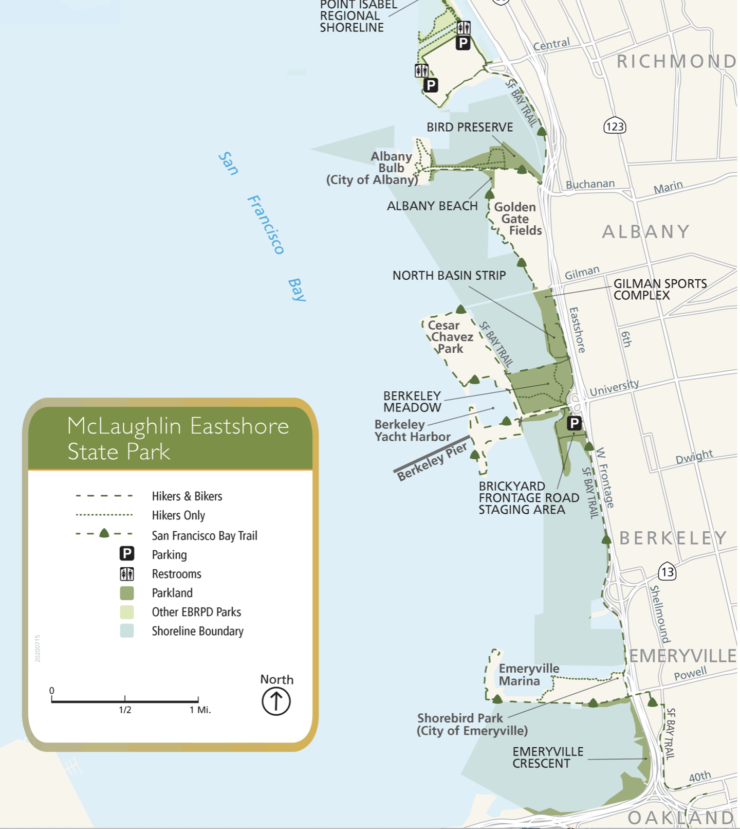
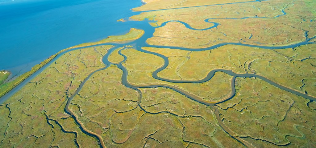
The subsequent designation of a large strip of coastal lands as a margin including Regional Protected Areas would later cover 1,833 acres of coastal lands and tidelands from the Bay Bridge to Richmond, along eight and a half miles of coast; the removal of all hazardous chemicals and garbage from 1998 restored the seasonal wetlands that were developing atop landfill in the seventy-two acre meadow, which was restored for $6 million over five years in a model to protect habitat and open space, as well as restoring a protective barrier of coastal wetlands that has long helped to protect the shoreline and bay. But the buy-in of 4,000 stakeholders in the multi-year project of habitat restoration and native habitat types however began from a protest map.

The complex bayshore that bridges four to five individual cities in the East Bay presents a complex picture of landscape and shoreline preservation and conservation, one whose sense of wonder and interest was in fact fought out in maps: if the mosaic of shoreline restoration, habitat preserves, parks, and greenspace that dot the coastline of San Francisco Bay between Oakland and Richmond offers a unique way of respecting open space on the margins of developed land, offering a landmark constraint for building out into the bay, the battle of visions for bay conservation were very much waged out through how mapping redefined the individual’s relation to local space and the world.
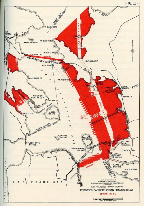
The story of coastal preservation that has often been cited as a model of a broad range of stakeholders began from a map. When the Save the Bay organization was formed by an improbably interested Berkeley patricians and Sierra Club members to prevent the waters from development and city housing that proposed building out into the bay in the post-war period. The military engineer John Reber drafted a plan that would reduce the bay dramatically, eliminating wetlands by adding landfill West Berkeley into the San Francisco Bay, in a monument of post-war engineering. The project of landscape modification bore all the hallmarks of modernity, and would have dramatically shrunk the bay’s open water, as much as open space, narrowing them by a massive fill to dramatically shrunken size, as well as the expansion of shipping lanes in Marin and Sausalito, that would have altered the Bay Area.

The triumphalism of the Army Engineers seemed almost to unite the U.S. Army bases in Alameda as a guideline to shape a modernistically sleek shoreline, punctuated by shipping corridors the open waters would accommodate. The expanded plan identified with Reber and the Department of Public works was announced quickly in the postwar era, as a massive project of infilling tidelands for a deepwater port, airports, and military bases by 1949, that would imagine an expansion of greater pierspace and nautical traffic in a Bay Area that seemed poise for financial growth as a hub of trade, as well as military outpost, expanding an “industrial site” in the smaller cities of Berkeley and Richmond, now equipping them with a airport terminals and a permanent Naval Base, and a Torpedo base in Hunter’s Point, expanding the military presence in northern California far beyond the military base in Alameda.
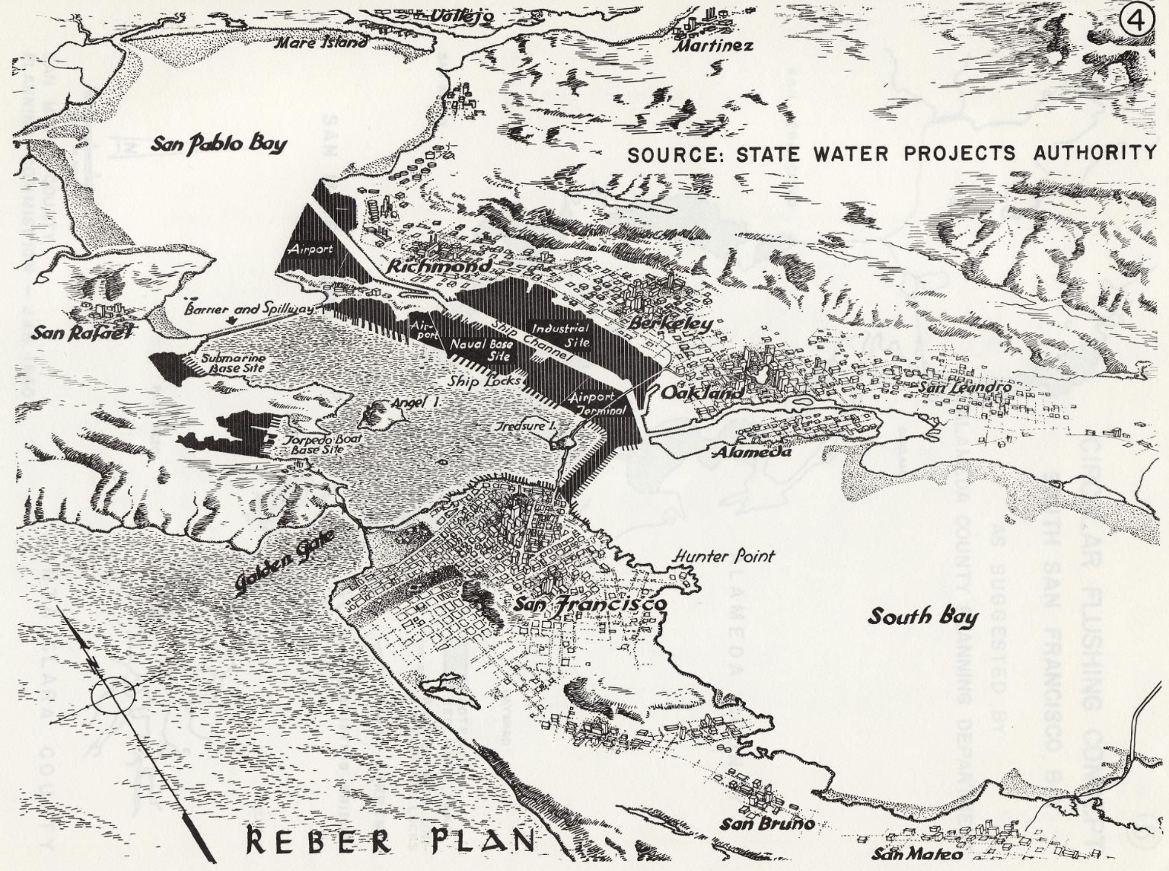
Although the proposal for a contraction of the open waters was set as a landscape view, as if to naturalize it within the scenery, the 1949 proposal attracted heightened possibilities of greater infill that led to the reduction of the San Pablo Bay after its development of a massive landscape intervention for ten years that is rightly included among possible destructions of San Francisco by overdevelopment, even if it would have impacted the entire Bay. But the proposal for subdividing and radically reinventing the San Francisco Bay and bayshore as a basis for further development came to a rather sudden halt after over ten years of expansion, stopping in its tracks the promotion of a a modernistic streamlining of bayshore and bay waters as sites of economic development, as the plans were adopted to proposae an alternative model of conservation.
The questions about conservation that were posed at the local level on the East Bay mounted a staunch opposition, applying pressure as it coalesced through the compelling rendering of an alternative map, questioning the public commitment to a new level of landscape change and leading to a sense of reckoning about bay waters. The logic of remapping the plans of development, and the effectiveness with which a map that posited the problems and dangers development posed, however won buy-in from multiple stake-holders–now exceeding 4,000–of huge consequence.
1. What allowed the revisioning of the Bay’s open waters to be preserved? The Reber Plan would famously attract condemnation as an artificial reduction of the open waters to a shipping land, the power of the map in mobilizing resistance suggests an episode of cartographic creativity as much as public mobilization.
But the very possibility of local resistance to such rebuilding preservation of greenspace in Tilden Park had no doubt provided a stunning achievement for the Works Progress administration, allowing land procured from East Bay Municipal Water District to be converted into the East Bay Regional Parks, in one of the great New Deal projects of land conservation, leading to a decade of landscape transformation across 4,300 acres, the potential of converting lands by the precedent that invited residents to explore the local greenspace must have provided an encouragement to the preserving the bay. And the cartographic celebration of the conservation of lands and expansion of East Bay parks was able to provide a powerful, and indeed liberating way to contemplate and engage the material landscape.
The luxurious relief maps created by the Civil Conservation Corps who had administered the East Bay parks through 1942, since restored, invitingly celebrated pathways to explore and navigate the greenspace in plastic form–made during the 1930s–that preserved an image of a sense of rural versus urban space, back in the days when the hills were far more green.
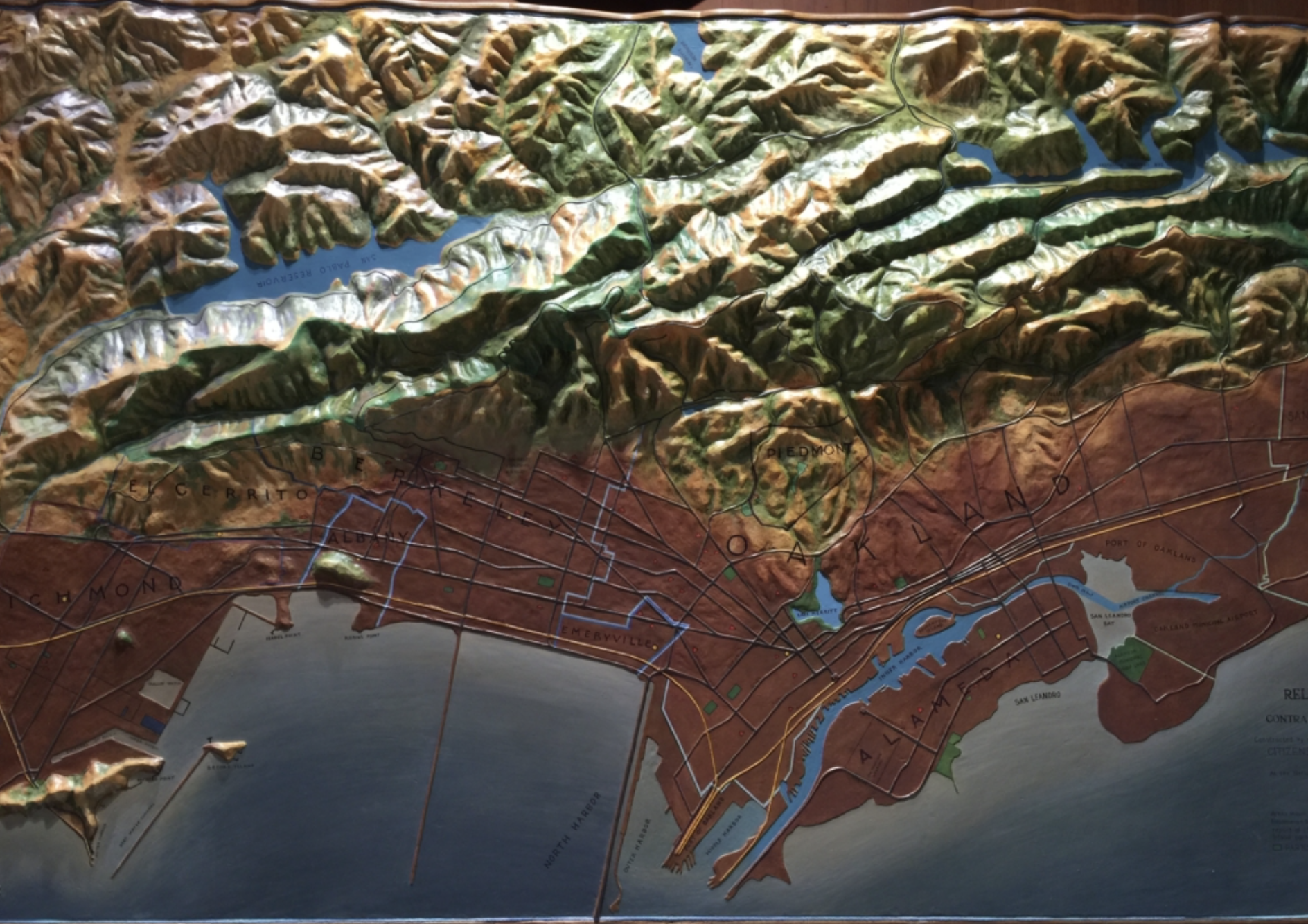
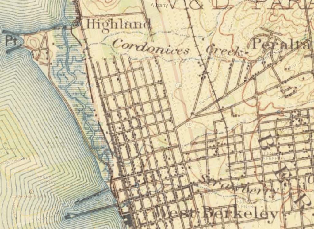
While the relation between the shore and bay is hardly the focus of the relief map made in the early 1930s for the East Bay Regional Parks–perhaps as a working model to demonstrate the easy linkage of city to open space that the acquisition of lands from the Water District allowed–the careful shading of the bay waters in a gradation from deep blue to the shore provided a quite detailed sense of the sensitive of land and sea that the detailing of several creeks underscores. The aesthetic contemplation of landscape was a consideration of land and bay–or demanded one, offering a rendering of the complex of open space, lakes, creeks, and estuaries as a unified whole, and aesthetic unity, that the transformation of the bay to a shipping channel–or “river,” as polemic maps of the Save the Bay project would affirm. The old piers of Berkeley’s marina was not clearly landscaped, but the shore was defined by the tracks of the railroad, in the restored East Bay Parks relief map in a model of conservation and what land conservation might achieve, and indeed the possibility of securing land against over-development, a plan accentuated by the addition of rustic architecture and monuments in Tilden, Lake Temescal, Sibley, and Redwood Parks. The monument to conservation that had become part of the sense of place contrasted in their ethos with the stark shipping lands that would have altered not only the shoreline, but the bay waters as well.
The counter-map of the Bay waters was inspired by the subsequent brutality of adding infill in the Reber Plan.
Designed with the apparent abandon of a crayon coloring book, in order to maximize the piers for arriving container ships in the postwar boom, the Reber Plan suggested a startlingly bold intervention in natural space to accommodate economic growth, crudely imposing economic infrastructure as if saddling it on the bay. For the Army Engineering Corps, the shallow East Bay coast, and large tidal lands, beckoned re-engineering provided a plan to envision the region in terms of “areas susceptible of reclamation” by the year 2020, back in 1957; years before the Bay Bridge, the bay’s low waters seemed ideal for a long-term plan of engineering a shipping corridor from Richmond to Oakland, domesticating the bayshore to maximize its economic utility and shipping locks would contracted San Francisco Bay, in a vision of development imagined in Washington, DC, with the endorsement of the US Chamber of Commerce.

For the project of land reclamation that the Army Corps of Engineers envisioned in the postwar era were a program to transform the settlement of the Bay Area in ways that extended pathways of marine communication by shipping industries as well as the U.S. navy in areas that were long predominantly marshland, imposing a dualistic opposition between “land” and “sea” in an area where the barriers between land and sea were blurred and fluid, and indeed on which local ecosytems were dependent: the eclipse of the regions of the Sacramento River’s expansive estuary were defined by marshland, tidal flats, wetlands, and in the East Bay shoreline, especially in Berkeley, seep or wet soil that the Plan did not register or accommodate, in its premium on economic expansion and strategic development. The coastal mapping projects that the United States Coastal Service had long engaged were put aside, and the stark land/sea duality proposed a limited way of seeing or imagining ‘development’ that seemed a logic of urban expansion that ran against the ways that the conservation ofEast Bay parks ha provided an important precedent to to manage, indeed taking it in different directions than the mapping of open space had set a powerful precedent by the 1940s–and a future that they would want to resist. If a full third of the bay had been diked off, infilled and built out that radically shrunk its open waters, Save The Bay was founded in 1961 to stop the acceleration of projected infill that would severely compromise the Bay, and has survived as an ecological monitor on infrastructure expansion and one-sided plans for development that would adversely affect the integrity of the Bay. The proposed reduction of wetlands and wetsoil along the Berkeley shore became a precedent for the ecological vulnerability of wetlands and bayshore to expansion, at a time when only a small fraction–but a tenth–of the Bay Area’s wetlands remained, and almost none of its shores were publicly accessible to residents, in the manner that the preservation of parks in the hillls provided such an important precedent that led directly to the 1965 foundation of The Bay Conservation and Development Commission (BCDC) to restrict or limit future projects of adding infill to reduce its open waters.
The relative murkiness of the areas the Army Corps of Engineers projected as ripe for infill envisioned a narrowed body of water without coastal access, in sharp contrast to conservation of greenspace around the expanding city:
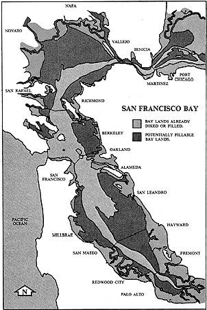

The vision of the massive constriction of wetlands, tidal marsh, intertidal plains, and shallow sea or seep soil marked 325 square miles a “potentially fillable bay” as if it was an area for potential economic expansion, as much as urban growth, developing the port city as a set of functional shipping channels, seeking to crystallize a notion of functionality that offered no space for conservation. While the infill would have doubled Berkeley in size, the dramatic disappearance of San Pablo Bay by a hundred miles, even if it wouldn’t have obviated need for the Richmond-San Rafael bridge, already opened in 1956, would have been a development project of San Francisco’s coast that expanded the considerable growth of San Francisco by landfill to the entire Bay Area.
The logic of development that the vision of the Army Corps of Engineers promoted publicly in 1961 Save the Bay crystallized around a cartographic revision of Reber’s map was, in a sense, a critical turning point, or crossroads–suggested by the etymology of the word “crisis”–in how the bay could be actively remapped in the face of development, more recently culminating in how San Francisco Estuary Institute has mapped past against present landscape to orient us to historical ecology of the man-made nature of the shoreline we have inherited.

Viewed a bit differently, in materials that were provided by Save the Bay, to situate the organic place of the bay within the western landscape, the rivers whose confluence runs into the Bay join waters from the Sacramento to San Joaquin rivers run to the San Francisco Bay as a delivery of sediment from the landscape, uniting the Sierra Nevada and Coastal Range in its waters.
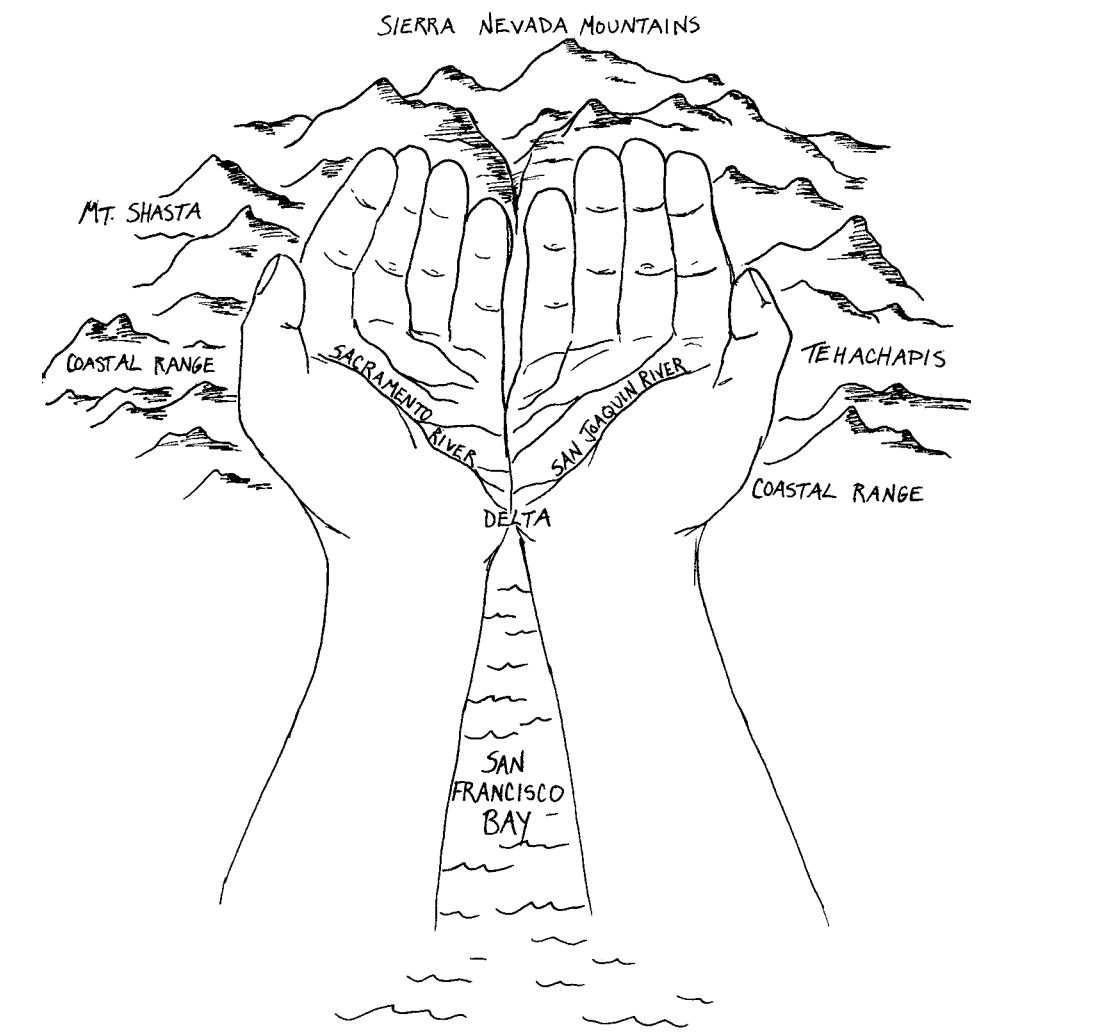
If the bottom topography of the Bay had been dramatically altered by the flushing of sediment downstream rivers as the Sacramento, sending sludge into the Pacific Ocean, the arrival of sediment may have set a precedent for the proposed addition of infill that would deliver unprecedented sediment to the San Francisco Bay’s seabed.

But the “green shoreline” of the East Bay suggested a unique biophilic resistance to the addition of landfill, preserving the sense of open waters with which this post began.

So radical was the scale of the transformation of the Bay that Reber drafted to provoke a catalyst for the collective buy-in for opposition at the start of the environmental movement. The counter-map became a rallying cry of the defense of the bay’s open water against development by the shipping industry that affirmed the defense of a privileged relation to place for Berkeley residents, shocked by the alienating nature of the expansion of the lines of old wooden docks that dotted much of Richmond and Oakland, the two largest harbors in the East Bay. The plan would have both promised economic development, and expanded housing, into the Bay, eliminating open waters by amalgamating harbors to a straight manmade shoreline that would have connected the San Rafael Bridge and Alameda Naval Station, imposing expanded shipping lanes over the bay waters, that, as its effects were mapped, were realized to radically threaten habitat. The remapping of the preservation of bayshore helped radically change the perception of the water from the land, that helped to create a place where, when one walks today, the city and San Francisco indeed recede across the tidal flats.


2. The plans for developing the coastline by the addition of bayfill that would create either a vibrant port for pacific shipping industry were stayed as a rallying cry to mobilize opinion around the planned bayfill that would contract the East Bay, erasing wetlands that would be landfilled, dike or leveed for development, as growth of the Bay Area in the postwar period had already brought the filling in of entrance of the Sacramento River and five other rivers to the unique wetlands complex of the Bay Area–a lost environment that has been contracted by urban expansion and the reshaping of the shoreline ecosystem of so much of the bay, from the south Bay to the north bay to the estuary complex that framers of the contracted image of the San Francisco Bay to shipping channels that Reber envisioned took for granted as an inevitable process of development–but which we are now far more liable to map in terms of loss.
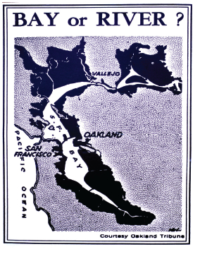
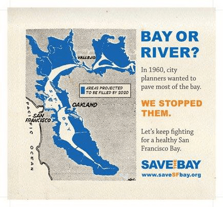
The protest to “Save the Bay” was animated by a counter-map that animated resistance that asked residents what sort of bay they wanted to live beyond. The abstract map of a landfill project of 1961 came to concretize the costs of development, and served–perhaps for the very reason that it was not detailed–to generate a broad coalition of protest against the imagined expansion of housing and shipping development in the East Bay. The printed map delineated how much was at stake in proposed coastal transformation so persuasively it became a powerful logo and rallying cry for the Save the Bay project from a new alliance of environmental groups and other stakeholders: if the military engineer’s map documented the modernistic redesign of the natural shoreline, in ways that extended the compromised habitat loss in other areas of the Delta and estuary, the convincing contrast between two visions of the bay–“Bay or River?” the map’s legend directly framed the future of the San Francisco Bay–put breaks on the continued development of much of East and South Bay. The map helped pose a simple question that asking readers to consider themselves stakeholders in a bulwark against massive environmental change in suggesting the near-apocalyptic scale of added landfill in dark black. While the story has been often told, the vital role an engineering map played in pushing back against vested propertied and industrial interests is arresting.
It was begun by a realization prompted from seeing a map announcing the future re-engineering of the San Francisco Bay, reprinted in the Oakland Tribune, and contemplating the possible extent of changes that would reconfigure the shore of an area that drains up to 40% of the land of the entire state, that prompted the preservation of its open waters. The prospect of such a radical remapping of the region’s open water–more than its shores alone–invested the planning map drawn up by the Army Corps of Engineers triggered the attention among three women over tea, contemplating the reduction o the Bay–and the beauty of vistas from their windows–against the areas up for potential expansion, that encapsulated and condensed the areas the Army Corps identified as susceptible for landfill.
The simple two-tone graphic generated a broad awareness of the region at a significant time in urban development, and helped to brakes on the inertia behind the radical reengineering of the bay as a shipping lane. The Save San Francisco Bay project that was the contribution of three women tied to educational groups and educators at the local university by marriage mobilized public opinion around the preservation as the wife of the past University President, Kay Kerr, herself “very disturbed about the filing of the bay” assembled a group disturbed by how “ongoing filling of the edges of the bay for airports, harbors, subdivisions, freeways, industrial sites and garbage dumps,” threatened to transform its open waters to a biological desert. Aptly, she calling an assembled group of conservationists and neighbors to order a meeting in a home overlooking the bay by a map of a produced by the Army Corps of Engineers calling for adding landfill that would leave “little more than a ship channel down the middle,” as she put it.
The City of Berkeley eager to expand to provide more housing, sought to double in size by filling in 2,000 acres of the bay shallows. Indeed, as late as 1980, the City of Berkeley hoped to expand the bay waterfront into a shopping center, resulting in the public trust over tidelands of the East Bay that preserved them from bay fill almost two decades later, in a suit that one of the first legal advisors of the Save the Bay Association directed as amicus curiae, in City of Berkeley v. Superior Court (1980) 26 Cal.3d 515, continuing to defend the bay wetlands’ integry against a defined shoreline.
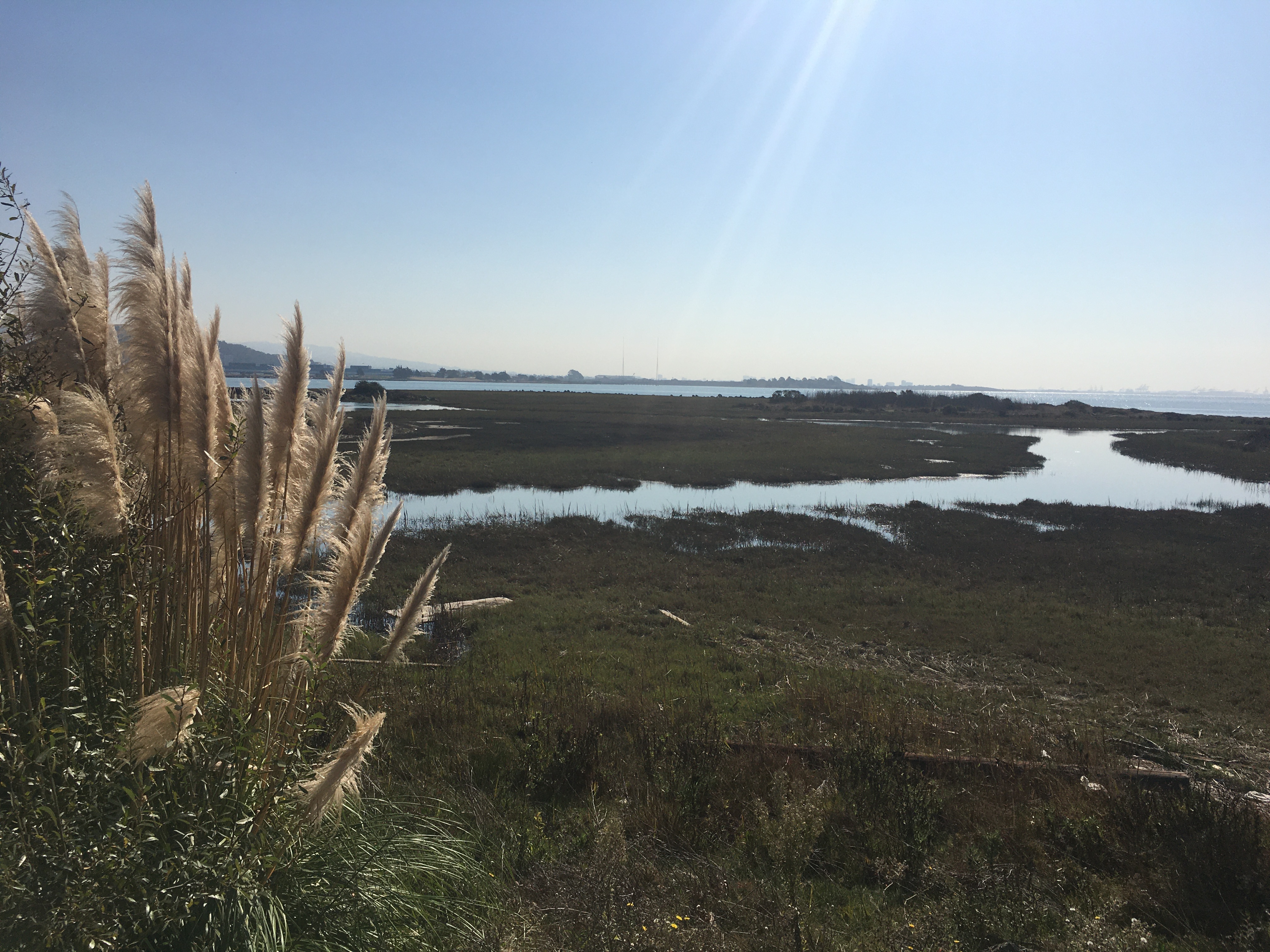
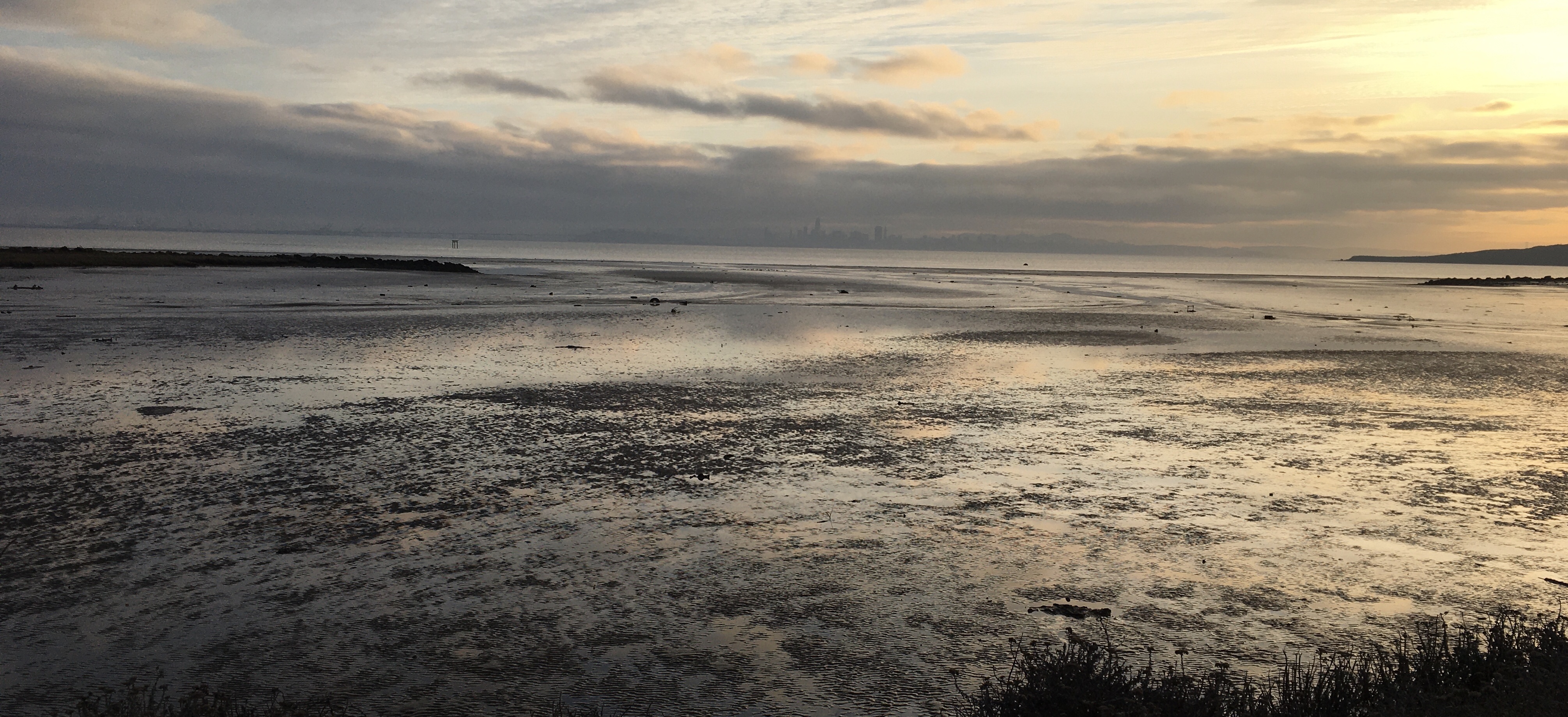
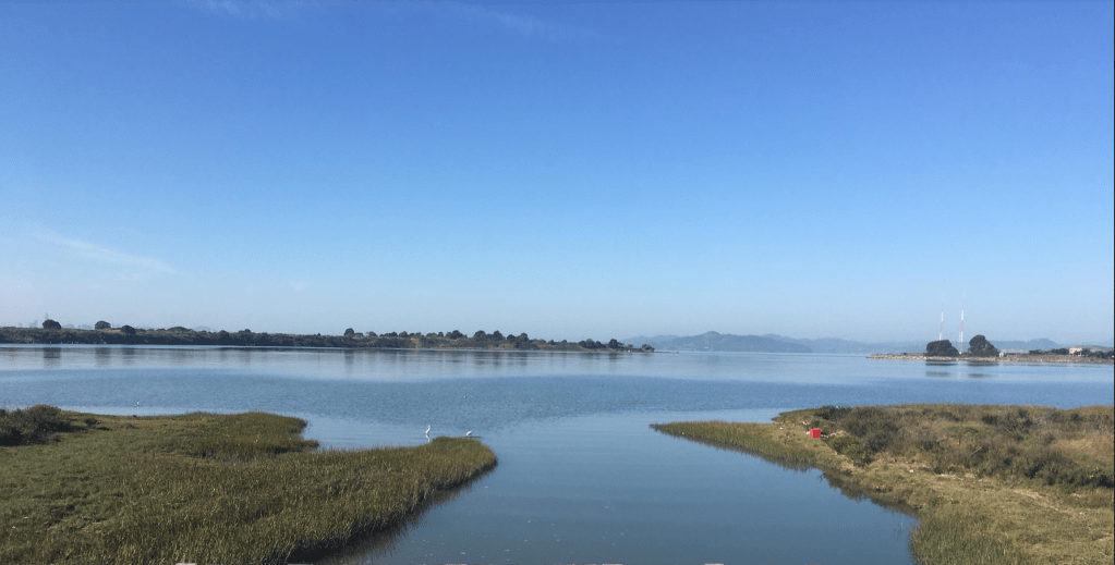
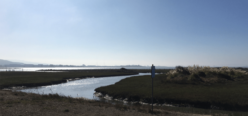
The ability to stop the projected bayfill set a precedent that altered the relation of citizen groups and ecologists to the preservation of coastal habitat and parkland. The power of the rhetorical contrast between two maps of the future framed a vision of the local environment and access to a coast in an effective manner that one can forget looking out over the living landscape of the Bayshore Trail, but that provides a powerful reminders of how maps mobilize consensus and embodied the wetlands and tidelands as a features we have only more recently detected in the Bay as a wetlands ecosystem, truly far from built space.
While we appreciate the restoration of the complex estuary along the Bayshore, as a fluid ecotone whose wetlands provide a rich habitat that is a success of land reclamation, the near-transformation of the eastern seashore of San Francisco Bay to a large development for housing may have eased the housing crunch afflicting the Bay Area, but would have erased that seashore, without public intervention, and prepared the restoration of the wetlands as a habitat, rebuilding the sinuous streams entering marshes as a delicate membrane of freshwater and saltwater.
Yet the master-narrative of land-reclamation along the San Francisco Bay had gained an increased inevitability of infill that only increased and augmented the sense of what open waters were “potentially fillable” in the future, for the U.S. Army Corps of Engineers, as the expansion of massive land-changing practices developed in wartime took advantage of new mapping expertise to map development at home.

The expansion of areas that were long know to be low-lying waters, filled with centuries of sediment, led Army engineers to plan contracting the San Francisco Bay to a narrow shipping channel by 2020. In response, the movement was laid for the eventual moratorium on future addition of landfill to the Bay, and agreement in a precedent-setting permanent agency overseeing all shoreline development–that called off expanding housing to the low-lying waters of the Eastern Bayshore.
Increased addition of landfill that had already reduced by the low-lying estuary of San Francisco Bay by a third, with the elimination of wetlands, and set a model for coastal zone managment that would be a model for ecological preservation.
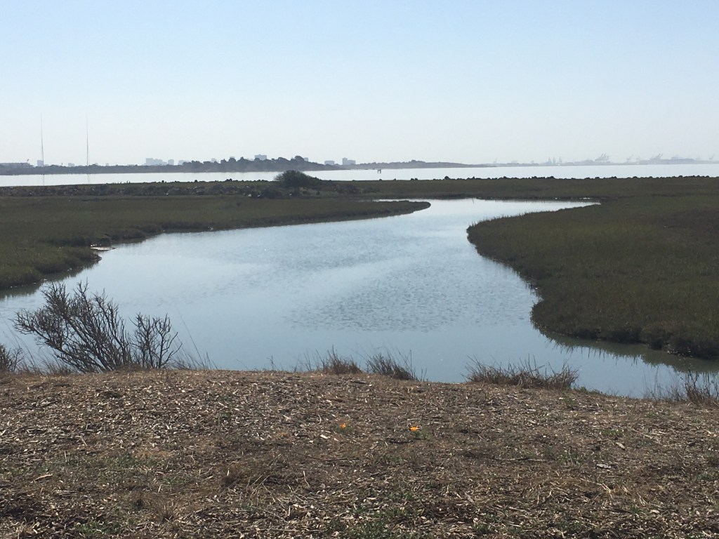
And the ability to restore much of the saltwater marshlands around the current Bay Trail and McLaughlin Park has helped to preserve the delicate ecotonal balance that is an ecosystem for shorebirds, owls, and other animals that a comparison between older and more recent maps of shoreline development of the old wetlands of the East Bay in the late nineteenth century, where freshwater creeks fed into salt marshes that provided a delicate shoreline coastal habitat.
The project for offshore expansion was only stopped by the Bay Conservation & Development Commission (BCDC), if the overlay of maps suggest the delicate nature of the loss of wetlands at risk.
Despite the complexity of a bay whose shore includes over forty cities on its waters and in at 550 miles is about half the coastline of the entire state, the reclamation map simplified the massive reconfiguration of the region in ways that omitted questions of habitat or preservation entirely absent in 1960. The extent of coastal reconfiguration of the South Bay that had already proceeded, redefining its sloughs and estuaries, were in a sene extended in the proposed land reclamation project that can be seen as a huge expansion of the early expansion of Marin near Tiburon, on a scale scarcely imaginable before the postwar period. If reclaimed land had begun in wharfs and piers that extended into the San Francisco Bay’s waters in Marin, Tiburon, San Francisco and to some extent the East Bay, the cancellation of cross-bay transit was expanded in the hopes to expand land reclamation far beyond imagined, beyond southern Marin, to transform the Bay into a functional waterway tied to transport terminals.
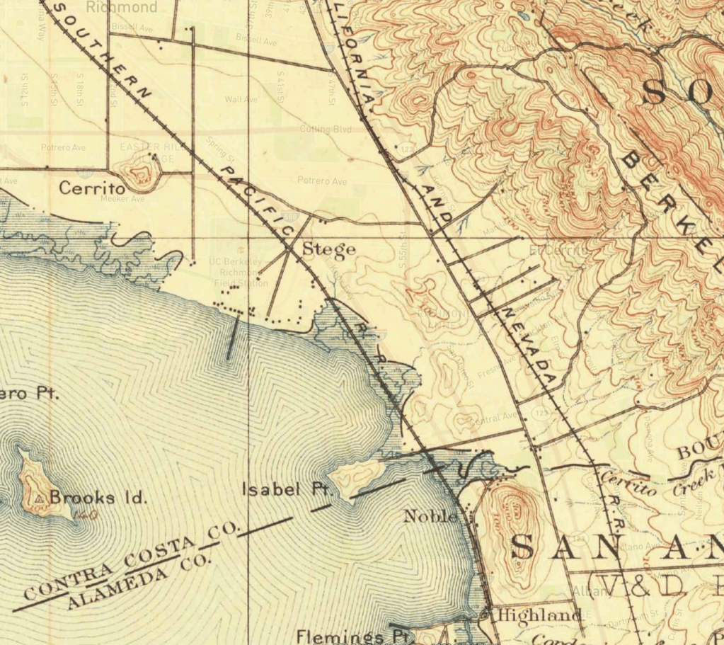
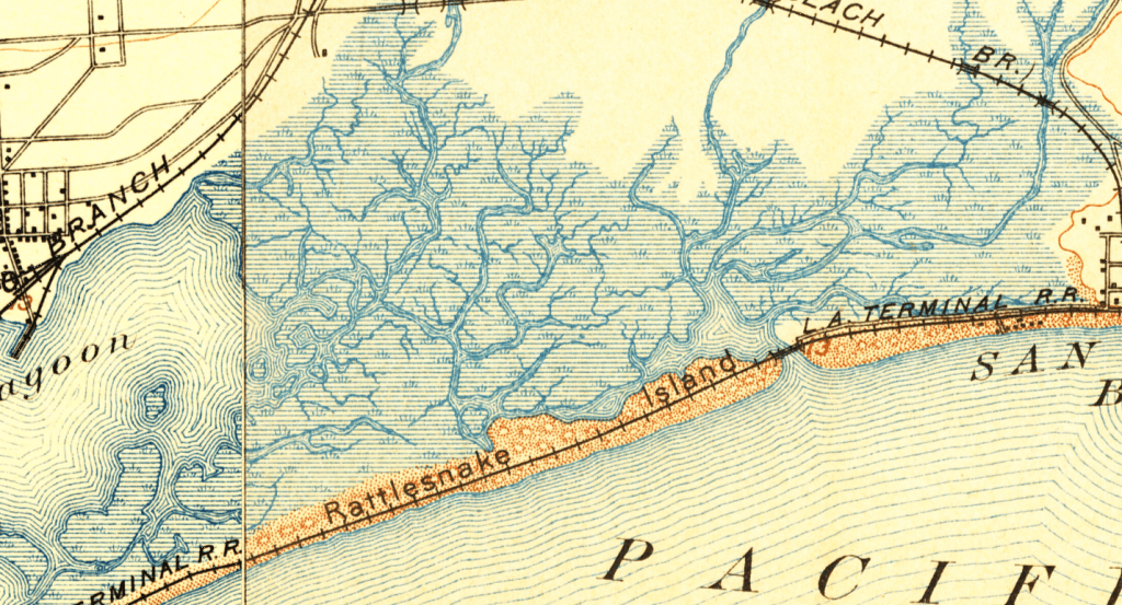
Early USGS maps reveal the cartographic care to the sinuous paths of water running through wetland marshes on the edge of the Southern Pacific line, near Pt. Isabel and El Cerrito, where the Cerrito Creek enters the bay, in many other smaller streams that sculpt the ecotone of the bayside shore.
Can we try to recuperate these strategies of mapping a complex continuity of shoreline less as a fixed line? The interest in adding landfill to expand the shore over these wetlands would have been a huge reshaping of shoreline that imagined the line as able to be crisp, and cut across the very habitat that the National Park would recreate as habitat and open space, but which twas built out in the mid-century as a a linear shore for more railroad line, as is revealed in the above superimposition of two USGS maps.
Perhaps the most authoritative and influential assessment of filling the Bay was the reaction to the project that the Civil Engineer’s map provided after it was diffused in the local press, and readily extrapolated by East Bay readers. If the logic of reclaiming the tidal zone of much of the South Bay and Marin had developed in the post-war period, filling almost nine hundred acres at the hope of housing over 10,000, had led to the Marin Conservation League after it was proposed in 1956, by raising funds to buy back the tidelands, with help from Marin County and the California Highway Department, and Belvedere, the bayshore had less clear alliances of mutual support and advantage to depend on, but redirected opinion through a very successful map to envision the almost dystopian consequences of transforming the lung-like bay into a shipping terminal the would expand the postwar growth of the old Kaiser Shipyards–but treat the shoreline as a corridor for shipping lanes.

U.S. Army Corp of Engineers. © Corps of Engineers
3. As we try to recuperate the mapping strategies to show the relation of by to water, we might revisit the reworking of the shoreline and its mapping in the local imagination, because the remapping of shores crystallized one of the most important early ecological movements of land preservation.
While the image of the proposed project for narrowing the San Francisco Bay with landfill has been long forgotten, it marked a striking rhetorical redeployment of an engineering plan to stir up public opposition to the narrowing of the harbor with bay fill that John Weber had enthusiastically advocated since the late 1950s into a movement protecting the open waters as a unique open environmental space. The transformation of a harbor that had been designed by the predominantly commercial mandates of a harbor was transformed into an ideal the aesthetic protection of open waters through the unexpected power of how the image of a lost landscape was evoked by the proposed augmentation of landfill additions that would allow the expansion of San Francisco and Berkeley as cities that could be traversed by cars; if Weber believed that the project he long championed would correct the “geographic mistake” by which the bay fragmented a master-plan for the region, seeking to shrink saltwater influx that had interrupted the expansion of a metropolis that would link Oakland and San Francisco. Reber may have compensated for his lack of formal education by his adherence to maps in his persistent promoting and continued evangelism of his vision of urban modernization of the Bay, relying on the plan as a theatrical device to accommodate the “geographic mistake” by the expansion of paved areas, locks, roads, and viaducts Robert Moses-style.
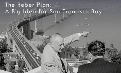
Reber gestures to the proposed area to be filled in San Francisco Bay
But the ultimate rejection of his plan came as the very image that proposed the effects of bay fill-reduced open waters was re-presented to invite viewers to consider the definitively changed relation to place that such a massive public works construction would create. For the map, reprinted beneath the three words “Bay or River?,” linked text and image to trigger resistance to the new relation to space that the disappearance of the Bay’s open waters would have implied. It prompted resistance to crystallize against the proposed public works projects to add bay fill to replace the saltwater active harbor with that would promote the expansion of urban spread and forever change the lived setting of the region. The addition of a simple interrogative invited viewers to imagine the landscape that they desired, “Bay or River?” not only attracted more immediate attention than any of REber’s maps but mobilized opposition to the effects of encroachment with the force of a public polemic of preserving an aesthetic–rather than only commercial–landscape.
At the same time as growing public awareness was directed to the mitigation of water pollution as discharging raw sewage and pollution into harbors and rivers diminished as a common practice with passage of the first water quality laws that led to the 1960 Clean Water Act, and five years later created the Land and Water Conservation Fund for recreational spaces. But the resistance to Reber’s plans for the closing of the open waters of the Sacramento Delta led to a collective topophilic rendering to the preservation of wetlands and estuary that prevented the impending additional of landfill to contract the San Francisco Bay that would have erased the estuary and bay alike, so resonant to lead the Save the Bay grassroots citizens’ movement to preserve and protect its open waters against the constriction of the Delta and estuary, and erasure of open spaces of wetlands.
The legend transformed a plan into a polemic: the legend made the map powerfully intersect with readers’s mental geographies; by inviting viewers to map which of two futures they wanted against their experience, the image became a lodestone for preserving the open space of the bay, as well as a powerful icon of regional topohilia and an emblem of resistance to the over-engineered landscape that we identify with the proposed shrinkage of the Bay to a canal whose space would have been dominated by barriers and ship locks.
4. The more complex relation of shoreline, wetlands, and creeks that feed the bay, so typical of the South Bay as well, and some of the most important sources of sediment delivery into the Bay–
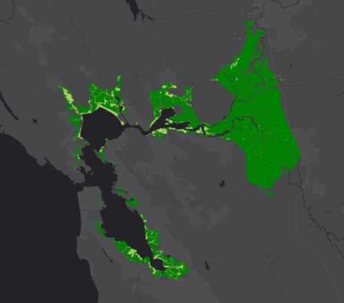
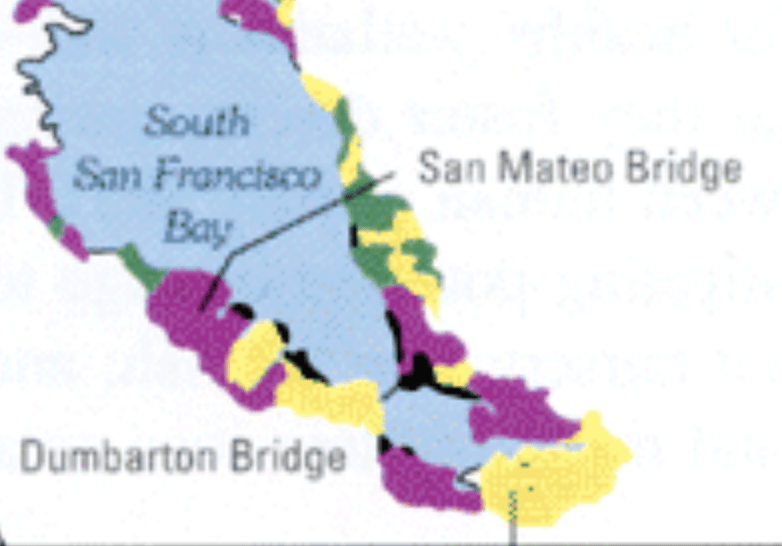
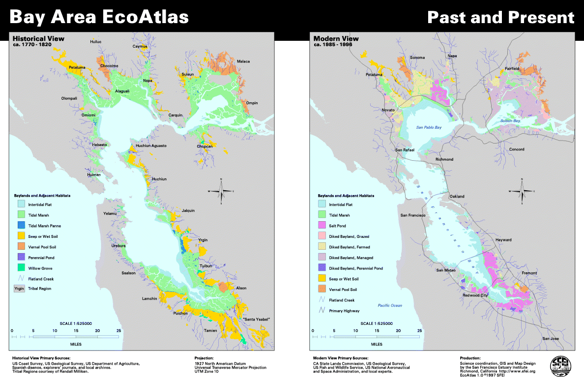
–and the many wetlands of the South Bay that were filled in during the postwar period from the 1940s, shown below in yellow, and the early areas of wetlands that were filled in or leveed 1900-1940, shown in purple, reducing some of the tidal marshes that were major areas of sediment accumulation and rich coastal wetlands.
Can we find a model of greater painstaking attention to the delineation of coastal areas that foregrounded now lost ecotones in older USGS maps that trace the definition of creeks and tidal marshes in lost historic wetlands later redefined and often obscured form maps by development and property claims? The historical tidal marshes around the Bay Area, from Albany and Richmond to Oakland, San Francisco, and Redwood City and Palo Alto, much as in Los Angeles or Green Bay, WI and New York survive in historical maps of wetlands, if they are now largely overwritten by property claims in urbanized areas by redrawing a definition of land and sea.


But the resistance and redefinition of the bay waters in Berkeley and the East Bay offered a counter-mapping of the shorelines that resisted the addition of landfill and set a stage for environmental preservation of shoreline habitat often lost to land reclamation projects.
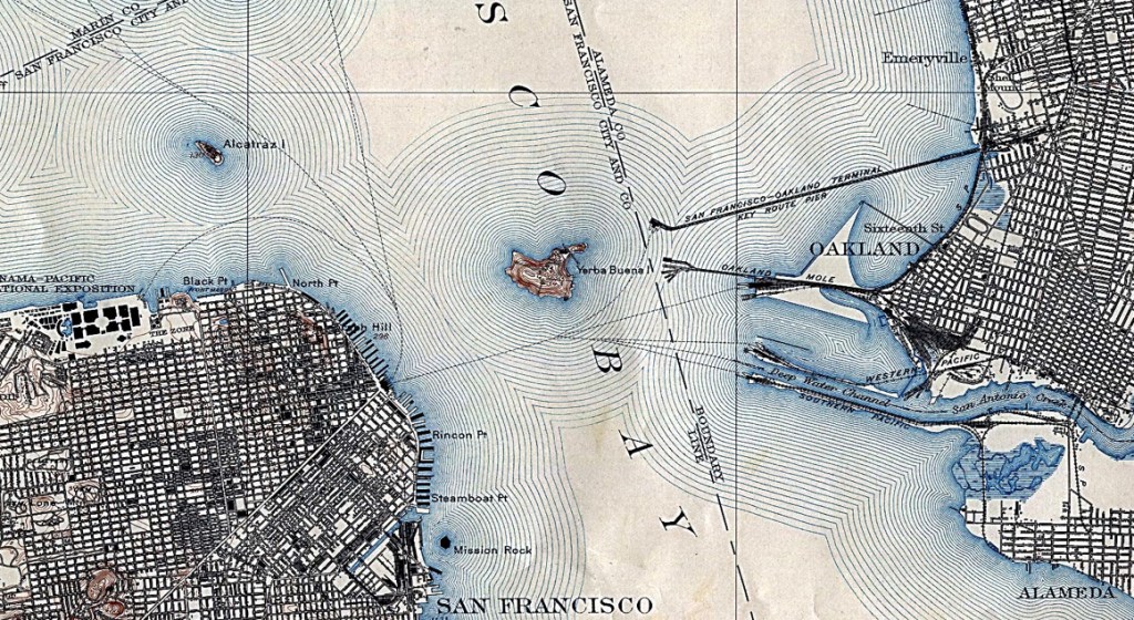
The map made and distributed by the Save the Bay movement showed land schedueld to be built out into the Bay Area by a delicate stippling of the sort that once might have indicated marine expanse in early modern engraved maps. But stippling is used to call attention to the projected landfill that would reduce the size of the San Francisco Bay considerably in the above newsmap. Indeed, the maps so alarmingly suggested the loss of open waters to landfill through the subsequent redefinition of the familiar shorelines into a set of what were clearly artificially narrow estuaries to be a cause for public alarm. The arrival of such an expanse of landfill could be described as achieved according to an artificial delivery of sediment that would be a massive feat of engineering. But the map, derived from an engineering proposal that sought to describe the extent of housing lots that might be created by the full expansion of landfill to fill the East Bay, in the model that had already erased Mission Bay and defined the Embarcadero in San Francisco, was less readily interpreted as an advancement of the march of progress as it met readers who were alarmed by the appearance of the reduced Bay’s shoreline.
The image of the shoreline that might have been still shocks–though it is easy to be understood also as a continuity with the increased amounts of landfill that defined the city as a peninsula. Rather than provide an illustration of triumphalist progress, however, the map became adopted as an icon of local resistance to engineering that redefined the ecological movement around 1962 and gave it a focus on the preservation of open waters that still exist. Mapping is deeply tied to cognitive modeling, as much as to precision, and the historical role that was played by the map that projected the expansion of levels of landfill across the East and South Bay were no exception. The map first designed for the project of the drastic reduction of San Francisco Bay that was first publicly floated around 1959 in the popular press provided a rallying cry for maintaining the current configuration of wetlands, before the idea of making the San Francisco Bay a habitat for birds and wildlife could have been even foreseen.
The land reclamation map produced in newspapers, portended helped to energize an unlikely movement, and provided a basis mobilize a rather unlikely coalition in favor of the preservation of the unique ecosystem–and indeed ensure the overlapping of environments of land and sea that are described as “ecotones”–in the Bay Area. The map, as it was adopted by Sylvia McLaughlin, Kay Kerr, and Esther Gulick of the fledgling “Save the Bay” movement, came to concretize and effectively embody deeply resonant and evocative relation to the liminal areas of its wetlands and its open space, at a time when some 30% of the San Francisco Bay had already been lost to landfill or diking. Maps provided a way to visualize the constantly shrinking space of the wetlands, without an eye to either environmental consequences or the potential loss of habitat, as the advance of reclaimed land seemed inevitably associated with the drumbeat of progress, pictured below in three relief maps that foresaw the expansion of landfill expected to steadily reduce the bay’s once watery expanse over the next fifty-five years, which seemed to create new acreage for housing or farming, enclosing once open waters by river banks, building upon the massive reclamation and redefining of the South Bay shores in the 1950s.

Those reluctant to encounter this almost inevitable expansion of landfill were not only undaunted by the map of the prospective shrinkage of the San Francisco Bay, and progress of the US Army Corps of Civil Engineers, which, according to a map that first appeared in the Oakland Tribune, envisioned a massive reduction by 70% of the Bay’s size by 2020 as part of the region’s modernization. While the future seemed inevitable, somewhat surprisingly, the same map was adopted and reprinted with the new legend “Bay or River?”, inviting readers to reflect on the very inevitability of the shrinkage of open waters with such force that it became a potent symbol and rallying cry.
The suasive force of the map marked a victory of self-determination for most residents–enlisting interested citizens, fearful of the map that the future showed, led three women to invite for coffee the directors of the Save the Redwoods League, Audubon Society, and Sierra Club, to describe the possibility of reversing the steady drip of garbage, sewage, and growing shoreline stench that must have encouraged the logic of extending landfill to an area where garbage was regularly dumped and set on fire, at night, fell on deaf ears, only with the growth of the Free Speech Movement, and as 90% of Bay wetlands were lost and the Bay already reduced by a third due to dumping garbage and land reclamation, the appearance of the map, “Bay or River?,” electrified resistance to redevelopment projects, and the creation of the Save San Francisco Bay Association.
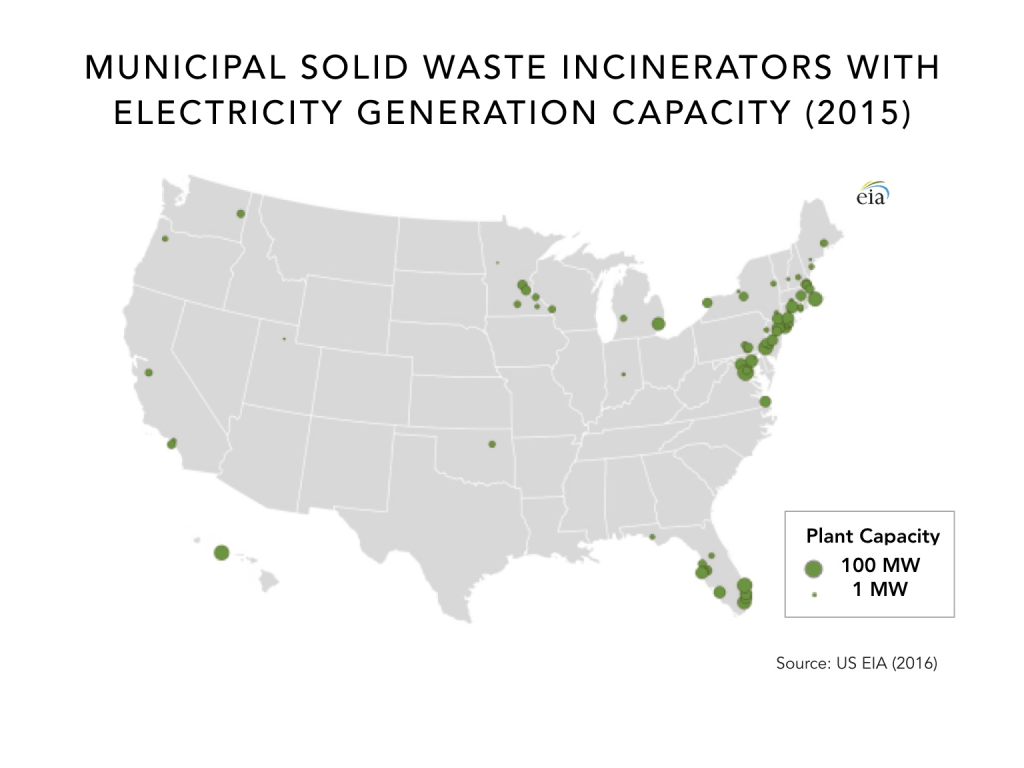
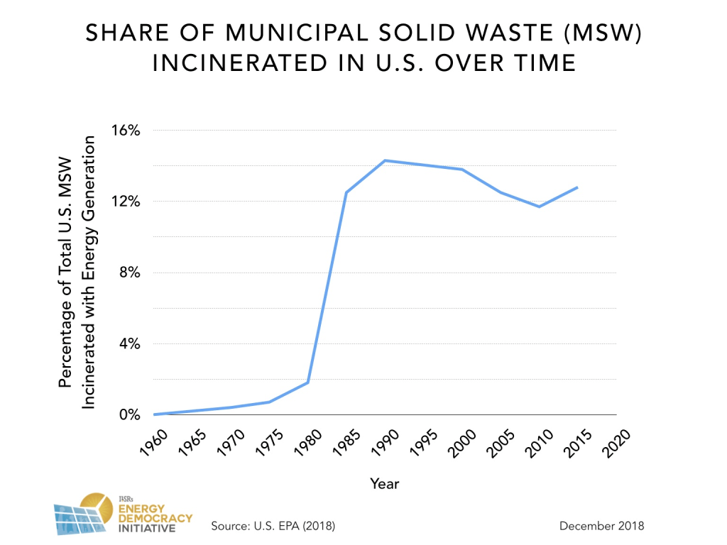
While the number of urban waste incinerators has grown massively in the United States in ways that have been quite misleadingly, and deceptively, been classified as “renewable” since the 1980s, in a public deception that has transformed waste management, and the energy sector, in a set of “trade-offs” that have led to the multiplication of Solid Waste Incinerators along the eastern seaboard, the relatively limited number of coastal incineration plants has become a pillar of coastal protection in western states, offering a distinctly different relation to the environment in which the resistance to anthropogenic land reclamation projects like the Save the Bay movements played no small part. The massive disposal of an average 30 million tons of municipal solid waste is sent to incinerators in recent years in the United States, far greater collectively than the 22 million tons composted, just below half the 67 million tons recycled, and a quarter of the 136 million tons landfilled, often posing health risks to disproportionately affecting people of color and low income, suggest a map of coastal pollution and incineration that the western states have resisted.
And for the group that approached the Berkeley City Council to turn back the fill project, the iconic emblem became a rallying cry of resistance for the “Save the Bay” movement–then “Save San Francisco Bay”–from 1962.
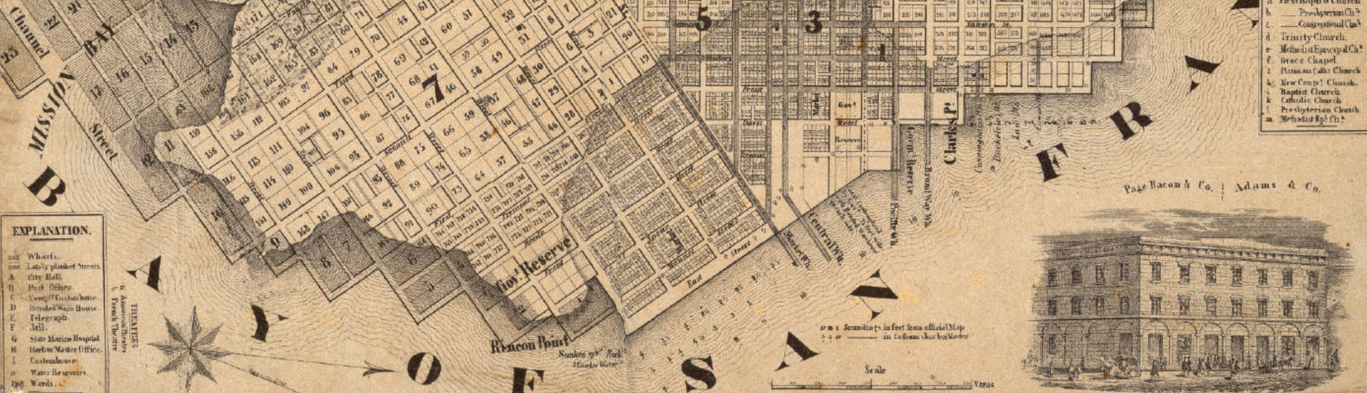
5. The expansion of San Francisco was closely tied to landfill, to be sure. Early maps of the city pointed out to builders when mapping out additions to the city as building lots, as rewriting its shoreline even as the historical shore remains a ghostly presence under the street grid in the nineteenth century, that suggests the scale of wetlands already lost or overbuilt: the expansion of the short of the city into the Bay of San Francisco was a gradual practice of urban expansion, even if the ghostly outline of the former shore remained encoded in maps as the 1852 Britton and Rey map “compiled from the latest Surveys & containing all late extension” that showed the “lately planket [sic] streets” atop landfill, and the considerable size of what might now be called a liquefaction zone that redefined what had been a harbor and would later become a set of piers, and reconfiguring a once undulating coast as a streamlined shore around a dense downtown.
 Britton and Rey, “Map of San Francisco, Compiled from the Latest Surveys . . . ” (1852) Courtesy the David Rumsey Map Collection
So complicated was the rendering of the proposed expansion of the additions of the mid-nineteenth century that the new additions to San Francisco seem to float above renderings of the current of the Bay, and the original coastline of the peninsula seem more prominent than the ghostly buildings and newly planked streets that lay atop.
 Britton and Rey, “Map of San Francisco, Compiled from the Latest Surveys . . . ” (1852) Courtesy the David Rumsey Map Collection
Rather than view the expansion of further landfill as inevitable, the redefinition of the shoreline of the city of San Francisco was more acceptable to prospectors than that of the Bay Area to East Bay residents, who were quick to see the dangers of the dramatic shrinking of the estuary as changing the experience of the Bay, and indeed removing Berkeley from the sea. The printing of an effective counter-map countered the project, which would be financially encouraged by David Rockefeller, of filling a full 60% of the shallowest bay waters with housing billed as a “New Manhattan”–and reduce the Bay, already surrounded by some thirty garbage dumps at that time, with a narrow shipping channel to serve Oakland’s port. The idea of reducing the waters of the Bay by a full 70%, which were deemed to serve no real “use” or function, aimed to transform it into what was deemed “usable” land, both for the expansion of public housing, and for an expanding of the East Bay some three miles into the ocean–somewhat improbably imagined by plowing the top off the San Bruno mountain and moving the future fill to the West.
There was little basis to understand the coherence of the water, or indeed its function, even as it was disappearing before the eyes of local inhabitants. The symbolic success of the map however not only mobilized public opinion behind the rejection of the continued landfill of the bay’s shallower areas, but the rejection of the continued dumping of waste into the Bay Area waters, and according to Richard Walker helped transform the ecology movement into a popular, rather than only an elite, cause. The image of filling some 2200 acres of watery expanse, reduced now to but a slender channel, provoked the project of saving the estuary, although most of the region was at that time closed off to public access, let alone ringed by a Coastal Trail as it is now: of the Bay’s 276-mile shoreline below the entrance of the Sacramento-San Joaquin Delta, less than 5 miles of shore were in fact open to public access.
The image of the destruction of the Bay was not focussed on the shoreline, of course, but rather on imagining the consequences of the potential loss of the open waters of the Bay that would change the relation of land to water in an irrevocable fashion. But the scale of the increasing anthropogenic moderation of the shoreline, in the name of land reclamation, has since led to a historical archeology of the habitats along the creeks and old coastal meanders of Mission Bay and much of the city of San Francisco, from the old U.S. Coastal Survey of 1859. That project seems to have no small tie to the cartographical revision of the vision for halting and stopping the land reclamation project of 1960, that would have remade much of Marin, the East Bay, and shrunk the South Bay in definitive terms.

Although the actual size of wetlands in the Bay had dramatically decreased since 1850, when land reclamation recast the undulating shoreline as an expansion of a rectilinear complex of streets, trumpeting the steady expansion of the city’s downtown area, and forming a newly rectilinear coast from Telegraph Hill to Market Street encompassing 800 sq miles, in a business section and erased the curving shoreline whose contours are since removed from public memory.
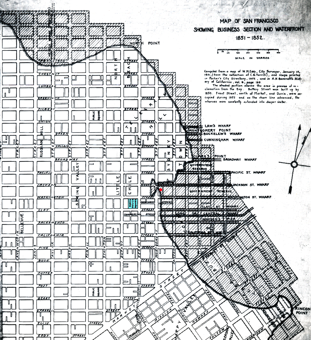
Indeed, the project rapidly accelerated the filling of marshland with landfill and residential and commercial construction that had already rapidly progressed since the turn of the century; the complex relationship between shoreline and bay in San Francisco was clear in the superimposition of an old coastline in the 1852 Britton & Rey survey, when a clear memory of the city’s earlier more restricted shape inhabits the urban grid, much as landfill expansion into Mission Bay were noted in contemporary engraved maps as one for the 1854 Exposition, which celebrates the expansion of the city by the Bay–even as it symbolically appears to wrestle with the newly configured street plan and lost wetlands by conspicuously indicating the earlier shoreline, as if to habituate its viewers to the shifting shorelines of the city–it extends the two grids of streets that extend from the central seam of Market Street so that they go off of the coastlines of the city, in a brave imagination of the expanding city whose shorelines will indeed grow outwards with future landfill dumps–obscuring the uneven shore of Ocean Beach or Mission Bay, or the run of piers that now reach out to San Francisco Bay.

Britton and Rey, “Map of San Francisco, Compiled from the Latest Surveys . . . ” (1852) Courtesy the David Rumsey Map Collection

Mechanics Library
The expansion of San Francisco from North Beach to the current Ocean Beach was prominently noted in 1854, tracing the expansion of city blocks landfill allowed and noting the fluid relation of the shore to the bathymetry of San Francisco Bay–in ways that make one realize the degree to which San Francisco was a precursor of Alameda.
The ghostly inhabitation of the landscape by past shores weren’t prominent in the spatial imaginations of city-dwellers by 1959, when the erasure of existing landscape of the industrialized city accustomed most to the prospect of extending the amount of landfill by which the San Francisco Bay had already been reduced, and redrawing the lines of its contours in a far more restricted form that would only allow entry of boats to its harbor.
 Britton and Rey, “Map of San Francisco, Compiled from the Latest Surveys . . . ” (1852) Courtesy the David Rumsey Map Collection


The first accurate cartographic depiction of San Francisco Bay was the chart executed by Frederick W. Beechey, who surveyed it’s waters in 1827 and ’28. It was published by the British Admiralty office in March,1833. All other charts and maps of this body of water were very distorted affairs prior to the Beechey map.