Blog Archives

The Imagined and Actual Geography of Brexit: Topologies of Social Anxiety

What sort of precedent did the Brexit vote sent for the validity of the demonization of immigration, and the growth of a firmly anti-globalist impulse?  The combination of a growing state security apparatus and economic insecurity on European boarders has created a fear of hordes and the arrival of migrants moving on foot that has created the now-dismantled migrant camp known as the “Jungle” near the port of Calais, not far from the Ferry Terminal for ships leaving for England.  This settlement became a site emblematic of the proximity of migrants to Britain in the summer of 2016, and helped to embody the fears of immigration close to the shores of England, giving a concreteness to the fears of immigration that deeply divided Britain on the need to protect its borders, and the dangers of doing so.  It was a debate about what being British meant, and where we draw our borders, which the Calais encampment, as the posters of refugees from Eastern Europe and Syria, illustrated with increased proximity.

Crossing to Calais on the Eurostar this summer, I looked out intently out of the rapidly moving train window for migrant camps who had been so central to the “Brexit” referendum by which  England recently left the European Union, that has held up to 6-8,000 refugees hoping to move to England–and some suggest the number reached as high as 10,000.  Indeed, as “Leave” seemed so successfully cast as an imperative, and “Remain” as the honest commitment to “Remain” seemed to have decidedly less media presence and staying power, the haunting residents of the camps, filled with refugees and migrants from Syria, Eritrea, Sudan and Afghanistan, if often left out of most maps of the election, provided a compelling if faceless specter for many.


f-calais-a-20160119.jpgReuters

_83530338_83530337.jpgBBC


The haphazard and improvised constellation of lean-tos, make-shift huts, and tents were ordered in streets beside orderly rows of fenced-off white metal shipping containers relocated to Calais to provide temporary forms of housing after their arrival.  Although there were not any migrant camps in evidence from my position in the train, the camps were in the past few weeks increasingly in the news, as the UKIP party that predicted an England inundated by refugee influx that social services and health could not accommodate, all because of England’s membership in the European Union, on the eve of Britain’s vote on the European Union Referendum–as “Leave” parties conjured fears of what belonging in the European Union would mean for the everyday Englishman in an age of increasing global displacement of refugees and cross-border traffic of men and women seeking work, education, and safety.  When the rapid train suddenly paused for unforeseen difficulties due to people on the tracks, one couldn’t but wonder how the halt related to those risking lives to enter the tunnel running beneath the Channel, whom local police quarantined in semi-permanent “homes” of converted shipping containers.

While the Eurostar connected two railway stations, and half of London and Paris was glued to the European Cup, the “Brexit” vote revealed a hiving off of about a third of Britain similarly eager to separate itself from the European Union–as voters voted, probably unaware of the consequences, in a plebiscite that trumped parliamentary politics in anti-democratic ways.  For Brexit became a performative mapping of a severance from Europe, in ways to manufacture an imaginary boundary between England and a refugee crisis.  The precarity of living in shipping containers now seems to be about as great as that of the European Union.  What was Jungle is largely destroyed, rendered uninhabitable save for the 1,200 unaccompanied minors who reside in the complex of huts, tents, and containers, as 4,403 migrants bussed to refugee centers across the country, to seek asylum, the settlement provided an effective threat of migration and effective specter of fear in the EU Referendum.  Indeed, it helped to ensure the surprising and unexpected success of a referendum designed to keep refugees at bay and finally withdraw the country –at significant national monetary cost–from the European Union for the foreseeable future.  As multiple fires began to burn in the Jungle after workers moved in to begin dismantling the camp, while some pointed the finger to refugees seeking to dismantle and erase the structures where they lived others pointed to British anarchists, even with the clearance began, so strong was the fear of migrants that the fate of 1,000 children seeking entrance to the UK is unknown, suspended by the post-BREXIT government of Theresa May.

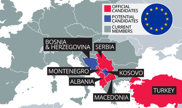
English voters on the Referendum were presented with almost dizzying fears of immigration and declining social services that were impossible to visualize adequately.  In an onslaught that dominated the news and challenged voters’ attention spans and moral compass, “Leave” flyers used fear to mobilize against remaining in the European Union.  In a canny onslaught and bid for attention, reminiscent of right-wing politicians, flyers of  “Leave” raised the specter of fears of immigration policies out of control  and wrested away by a European Union whose member states stood only to escalate.  The eventuality of remaining in the EU was seen as an abdication of responsibilities, and a misplaced trust in Brussels to control the entry of refugees and Eastern Europeans seeking jobs into the UK:  if migration to the UK had grown to above a quarter of a million–“the equivalent of a city the size of Newcastle“–the arrival of two million over the coming decade mandated by “free movement of people”  conjured a suitably dystopian future.  Voting to Remain in the European Union was to accept this lack of control, and the subordination of British law to an over-reaching European Court; expanding the myth of foreign oversight of Britain, Leave claimed to offer the opportunity to check the flow of migrants to restore control to British hands.  The argument of empowerment may have been deluded.  But the powerful promise to return £350 million in taxes flowing to Brussels, and the prospect of immigration growth once such “candidate countries” as Turkey, Serbia, Macedonia, and Montenegro joined Romania, Bulgaria, and Croatia, to the tune of a cost of nearly £1.8 billion, provided a compelling rationale to vote “Leave” and to identify interests with the possibility of controlling the fair of the expanded borders of globalization alone, and rather than in the European Union.  As a movement of “faux populism,” carefully orchestrated to be effective at the ballot, the Brexit supporters stirred up fear into a central role in the election that attracted a growing range of supporters to the ballot.

The dizzying expansion of a region without frontiers was joined by a cry “to take back control” of England’s future.  The Referendum was presented as “our last chance to take back control,” a virtual mantra of the Leave campaign, and control “our borders” and international “influence” lest the nation be filled with immigrants against who one can draw no clear border.  With the Turkey, Serbia, and Macedonia joining the EU, ran the implicit message, Syrian refugees were bound to be waiting at the gates as well, without a compelling way to turn them back.


EU-523932.jpgDaily Express


Such a compelling framing of the debate about the nation’s compromised future in a landscape of expanding “rights” fostered fears of an end of public futures, “without handing our permanent control to people we cannot vote out”–as if the vote presented the last attempt at independence, ignoring the special relation of the UK had long insisted to the EU.  To be sure, the Leave campaign also increased regulations that the EU introduced, without suggesting other financial benefits.

The mapping of the response to the Referendum released a new plethora of maps in hopes better to explain the final vote of the plebiscite that precipitated the break from the EU.  Can these maps–and the mapping of social divides in England’s complicated tapestry of islands which integrate immigrants and regions where they still remain unknown, provide any insight in the difficulty to create consensus about the growing population flows that globalization has produced?  The question is important, because it suggests a new problem of political consensus not only in Britain and the European Union, but also in the United States.  For the unprecedented misinformed plebiscite gave voice to a deep unease with parliamentary deals that brokered the terms of England’s membership in the European Union, and with globalization, that dangerously undermined the responsibilities that the EU has gained to respond to the global threats of refugee crises–a role that has been foisted upon it by the economic promise Europe continues to offer as a zone without apparent national frontiers.  While we’ve been told by informed voices that the EU “had it coming,” whatever that means, or that the current European Union compromised British demands, or warned that the creation of social and political affinities could ever follow from enforced economic union, or give rise to public confidence, rejection by plebiscite of membership in the European Union subverted democracy, by a campaign bred from xenophobic fears and assertions the EU “has failed Britain” as a whole.

The recourse to demographic polling, hex bin maps sought to go beyond easy dichotomies, and unpack what seem deep-running fault lines within the country, and the difficulty of reconciling the nation given the increased political fault-lines attempted to process and reconcile divides in political parties that plagued the land.  But rather than suggest the complex lines of fracturing between the political mosaic of Conservatives, Liberals, Labourites, UKIP and Greens in England’s new political landscape, the Leave/Stay dichotomy revealed new divides in the body politic.

.

independent.png


Despite the many tired dichotomies that have been extracted ad nauseam from data visualizations of the EU Referendum–from old v. young, north v. south, working class v. metropolitan elites; educated v. non-graduates; identifying as “English” v. cosmopolites–the complexion that has redefined the country reflects a growing retrograde tendency of rejecting the status quo and belief in the benefits of hiving off that was undemocratic and displayed  a perverse nostalgia of deeply conservative roots.


Queen Backs Brexit!.png


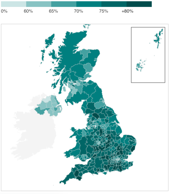
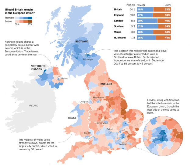
The referendum that former Prime Minister David Cameron presented as a panacea or safety valve to staunch opposition to the EU in Great Britain encouraged one of the most badly informed electorates in memory to protest the entrance of eastern Europeans into the country, and the perception of economic malaise and overburdened public services, and erase the benefit of free trade accords and that led to considerable economic growth.  The economic amnesia Brexit provoked led to a massive rejection of the national government and indeed political elites, even when undermining their economic interests, producing the increasing likelihood that many wish to leave Britain even among working class groups in England and Wales, and many voters more angry about the EU government than aware of the actual impact on trade relations to Europe or manufacturing and health standards.  Although turnout was in general quite high, with 30 million expressing their opinion at the ballot box, or some 72%, the vote was predicted to be determined by turn-out, and the distribution of votes varied.  If most in Scotland turned out, many in London and in northern Ireland voting less, and many of the regions who voted to “Leave” turned out to vote intensely–and turnout markedly lower in areas with greater numbers of younger voters–who tended to vote to Remain in reflection of their economic futures, especially in areas with greater student populations in relative to their size.  But the appeal to the nation and national independence deeply obscured the issues on the table.


TurnoutBBC

brexit-map-1-1371x1200


What was Cameron thinking in opening up this question to a plebiscite that gave greater voice to those with stronger opinions, and indeed in opening up a question of particular complexity to a public yea or nay vote that hinged on turn-out?  Democratic “consent” to membership in the EU was long been “wafer thin” in much of Britain, and low turnout among the young gave a greater share of the vote to Brexit.  But the opportunity that the vote offered many the chance to decamp from the EU in ways few intended.  For during a refugee crisis, the cards were steeply stacked the party reduced to take “Remain” as its slogan, although the very passivity of whose construction suggested an absence of cogent arguments to respond to false promises of helping England’s shaky economy, persistent low wages, growing waiting times at National Health Service, and rising rents–all of which were represented as stretched thin by serving migrant workers and their families, and rising rents.

Partisans of “Leave” tapped such concerns so effectively that despite the value of data visualizations in anatomizing and describing the broad distribution of adherents mobilized behind a “Leave” mandate, the vote seems little understood or analyzed for its appeal as in its ramifications, and has created an ongoing puzzle about what place of England will now occupy in relation to the EU–or how the EU will look.


Brexit?.png


Continue reading

4 Comments

June 28, 2016 · 11:26 pm

Urban Modernity, RIP: Mapping Marshall Berman Mapping Modernism

The meaning of place seems especially difficult to retain in an age of increased mobility, when information flows are increasingly removed from any site, and offer multiplying perspectives.  The work of cultural critic Marshall Berman (1940-2013) provides a clear eyed way to recuperate modernism through the inhabitation of place.  Berman, a long-time New York City resident and echt urbanite, created rich qualitative maps of literary modernism that rhapsodized cities as places–as privileged and vital sites of generating meanings that were rooted in place.  Even after his recent death, it’s hard not to be struck by the vitality that he mapped as rooted in cities, and whose existence he never stopped reminding us about and celebrating.  A native New Yorker, Berman wrote from committed engagement in New York’s space and shifting fluidity, and in his works mapped the sense of fluidity or perpetual permutability of urban life.  He showed us, in so doing, that maps are not only imposition from above, or Olympian views, but can map daily encounters best registered on city streets.  Even when I best knew Marshall in the 1970s and 1980s, he was one of the inveterate street-walker of the Upper West Side and Broadway who exulted in most everything he noticed on the street.  Marshall maybe increasingly became an inveterate street-walker who took pleasure in public space, and enjoyed claiming for himself a spot on the street, finding a sort of release and liberation on the night-time sidewalks, in Times Square, or at the diners where he so loved to sit.

In retrospect, I imagine his championing of the street’s energy came from the magnum opus he was then completing, All That is Solid Melts into Air (1982)–but that his love of street-life also shaped his voracious exploration of the space of literary modernism through the act of being in public.  For Berman quickly recognized that the depersonalization of urban life was not only the trauma and drama of modernity, but, transfigured by literary expression, also a privileged site for individuality.  In ways that are still resonant, his generous mapping of the modernity among cities extended from the city that he loved to the modern urbanism.  R.I.P., Marshall.

Berman’s sudden and unexpected death in a booth at the Metro Diner, at the heart of the Manhattan Upper West Side, can’t but provoke a reflection on his relation to the concept of urban space, from the sense of public space he lived and explored relentlessly as an observer and city-dweller to that which he read so very widely to excavate and explore with a canny sense of the personalized human geography.  For Marshall loved the lived urban environments and continued a life-long fascination he had with the living nature of a streetscape illuminated by electric lights, as if an ecosystem of the Great Barrier Reef, whose deeply modern possibilities he always felt beckoned and invited and which he was eager to explore.  Marshall’s recent death has prompted several emotional reflections that note the inescapably autobiographical aspects of his work, some of which he would himself, surely, be the first not to hesitate to note.  Marshall’s work was, first and foremost, that of a public intellectual who bridged personal criticism with urbanism.  For Berman often described his engaged writing on modernism and modernist projects of urban space as part of the creative projects of his life.

Continue reading

Leave a comment

November 22, 2013 · 4:02 pm

Mapping Open Waters: Bay or River?

The relation between land, sea, marsh, and landfill provided something of a dilemma of cartographical rendering in the Bay Area, mirroring the fluid relationship that has long existed between land and sea.  But if fluidity of the shoreline of the San Francisco Bay was less understood in terms of erosion, global warming, coastal flooding, and king tides back in the 1950s, the human fiction–and graphical statement–of the map of expanded bay fill provided a potent image to engage the shifting contours of land and sea.

The grassroots community activists reacted to it to protest plans for a radical narrowing of the Bay, whose success created the first inter-city compact for shoreline preservation with broad consequence for habitat conservation in the Bay Area–preserving tidal flats, coastal marshes, and wetlands that stand as a living model for conservationists, in close proximity to the city and coastal highway–as well as a legacy of the protection of open waters.

The subsequent designation of a large strip of coastal lands as a margin including Regional Protected Areas would later cover 1,833 acres of coastal lands and tidelands from the Bay Bridge to Richmond, along eight and a half miles of coast; the removal of all hazardous chemicals and garbage from 1998 restored the seasonal wetlands that were developing atop landfill in the seventy-two acre meadow, which was restored for $6 million over five years in a model to protect habitat and open space, as well as restoring a protective barrier of coastal wetlands that has long helped to protect the shoreline and bay. But the buy-in of 4,000 stakeholders in the multi-year project of habitat restoration and native habitat types however began from a protest map.

The complex bayshore that bridges four to five individual cities in the East Bay presents a complex picture of landscape and shoreline preservation and conservation, one whose sense of wonder and interest was in fact fought out in maps: if the mosaic of shoreline restoration, habitat preserves, parks, and greenspace that dot the coastline of San Francisco Bay between Oakland and Richmond offers a unique way of respecting open space on the margins of developed land, offering a landmark constraint for building out into the bay, the battle of visions for bay conservation were very much waged out through how mapping redefined the individual’s relation to local space and the world.

The story of coastal preservation that has often been cited as a model of a broad range of stakeholders began from a map. When the Save the Bay organization was formed by an improbably interested Berkeley patricians and Sierra Club members to prevent the waters from development and city housing that proposed building out into the bay in the post-war period. The military engineer John Reber drafted a plan that would reduce the bay dramatically, eliminating wetlands by adding landfill West Berkeley into the San Francisco Bay, in a monument of post-war engineering. The project of landscape modification bore all the hallmarks of modernity, and would have dramatically shrunk the bay’s open water, as much as open space, narrowing them by a massive fill to dramatically shrunken size, as well as the expansion of shipping lanes in Marin and Sausalito, that would have altered the Bay Area.

Proposed Barriers in San Francisco Bay (Reber Plan)

The triumphalism of the Army Engineers seemed almost to unite the U.S. Army bases in Alameda as a guideline to shape a modernistically sleek shoreline, punctuated by shipping corridors the open waters would accommodate. The expanded plan identified with Reber and the Department of Public works was announced quickly in the postwar era, as a massive project of infilling tidelands for a deepwater port, airports, and military bases by 1949, that would imagine an expansion of greater pierspace and nautical traffic in a Bay Area that seemed poise for financial growth as a hub of trade, as well as military outpost, expanding an “industrial site” in the smaller cities of Berkeley and Richmond, now equipping them with a airport terminals and a permanent Naval Base, and a Torpedo base in Hunter’s Point, expanding the military presence in northern California far beyond the military base in Alameda.

Reber Plane for a deepwater port, airports, and military bases (1949)[1580 x 1224]

Although the proposal for a contraction of the open waters was set as a landscape view, as if to naturalize it within the scenery, the 1949 proposal attracted heightened possibilities of greater infill that led to the reduction of the San Pablo Bay after its development of a massive landscape intervention for ten years that is rightly included among possible destructions of San Francisco by overdevelopment, even if it would have impacted the entire Bay. But the proposal for subdividing and radically reinventing the San Francisco Bay and bayshore as a basis for further development came to a rather sudden halt after over ten years of expansion, stopping in its tracks the promotion of a a modernistic streamlining of bayshore and bay waters as sites of economic development, as the plans were adopted to proposae an alternative model of conservation.

The questions about conservation that were posed at the local level on the East Bay mounted a staunch opposition, applying pressure as it coalesced through the compelling rendering of an alternative map, questioning the public commitment to a new level of landscape change and leading to a sense of reckoning about bay waters. The logic of remapping the plans of development, and the effectiveness with which a map that posited the problems and dangers development posed, however won buy-in from multiple stake-holders–now exceeding 4,000–of huge consequence.

1. What allowed the revisioning of the Bay’s open waters to be preserved? The Reber Plan would famously attract condemnation as an artificial reduction of the open waters to a shipping land, the power of the map in mobilizing resistance suggests an episode of cartographic creativity as much as public mobilization.

But the very possibility of local resistance to such rebuilding preservation of greenspace in Tilden Park had no doubt provided a stunning achievement for the Works Progress administration, allowing land procured from East Bay Municipal Water District to be converted into the East Bay Regional Parks, in one of the great New Deal projects of land conservation, leading to a decade of landscape transformation across 4,300 acres, the potential of converting lands by the precedent that invited residents to explore the local greenspace must have provided an encouragement to the preserving the bay. And the cartographic celebration of the conservation of lands and expansion of East Bay parks was able to provide a powerful, and indeed liberating way to contemplate and engage the material landscape.

The luxurious relief maps created by the Civil Conservation Corps who had administered the East Bay parks through 1942, since restored, invitingly celebrated pathways to explore and navigate the greenspace in plastic form–made during the 1930s–that preserved an image of a sense of rural versus urban space, back in the days when the hills were far more green.

While the relation between the shore and bay is hardly the focus of the relief map made in the early 1930s for the East Bay Regional Parks–perhaps as a working model to demonstrate the easy linkage of city to open space that the acquisition of lands from the Water District allowed–the careful shading of the bay waters in a gradation from deep blue to the shore provided a quite detailed sense of the sensitive of land and sea that the detailing of several creeks underscores. The aesthetic contemplation of landscape was a consideration of land and bay–or demanded one, offering a rendering of the complex of open space, lakes, creeks, and estuaries as a unified whole, and aesthetic unity, that the transformation of the bay to a shipping channel–or “river,” as polemic maps of the Save the Bay project would affirm. The old piers of Berkeley’s marina was not clearly landscaped, but the shore was defined by the tracks of the railroad, in the restored East Bay Parks relief map in a model of conservation and what land conservation might achieve, and indeed the possibility of securing land against over-development, a plan accentuated by the addition of rustic architecture and monuments in Tilden, Lake Temescal, Sibley, and Redwood Parks. The monument to conservation that had become part of the sense of place contrasted in their ethos with the stark shipping lands that would have altered not only the shoreline, but the bay waters as well.

The counter-map of the Bay waters was inspired by the subsequent brutality of adding infill in the Reber Plan.

Reber Plan: Proposed Barriers in San Francisco Bay (1959)

Designed with the apparent abandon of a crayon coloring book, in order to maximize the piers for arriving container ships in the postwar boom, the Reber Plan suggested a startlingly bold intervention in natural space to accommodate economic growth, crudely imposing economic infrastructure as if saddling it on the bay. For the Army Engineering Corps, the shallow East Bay coast, and large tidal lands, beckoned re-engineering provided a plan to envision the region in terms of “areas susceptible of reclamation” by the year 2020, back in 1957; years before the Bay Bridge, the bay’s low waters seemed ideal for a long-term plan of engineering a shipping corridor from Richmond to Oakland, domesticating the bayshore to maximize its economic utility and shipping locks would contracted San Francisco Bay, in a vision of development imagined in Washington, DC, with the endorsement of the US Chamber of Commerce.

For the project of land reclamation that the Army Corps of Engineers envisioned in the postwar era were a program to transform the settlement of the Bay Area in ways that extended pathways of marine communication by shipping industries as well as the U.S. navy in areas that were long predominantly marshland, imposing a dualistic opposition between “land” and “sea” in an area where the barriers between land and sea were blurred and fluid, and indeed on which local ecosytems were dependent: the eclipse of the regions of the Sacramento River’s expansive estuary were defined by marshland, tidal flats, wetlands, and in the East Bay shoreline, especially in Berkeley, seep or wet soil that the Plan did not register or accommodate, in its premium on economic expansion and strategic development. The coastal mapping projects that the United States Coastal Service had long engaged were put aside, and the stark land/sea duality proposed a limited way of seeing or imagining ‘development’ that seemed a logic of urban expansion that ran against the ways that the conservation ofEast Bay parks ha provided an important precedent to to manage, indeed taking it in different directions than the mapping of open space had set a powerful precedent by the 1940s–and a future that they would want to resist. If a full third of the bay had been diked off, infilled and built out that radically shrunk its open waters, Save The Bay was founded in 1961 to stop the acceleration of projected infill that would severely compromise the Bay, and has survived as an ecological monitor on infrastructure expansion and one-sided plans for development that would adversely affect the integrity of the Bay. The proposed reduction of wetlands and wetsoil along the Berkeley shore became a precedent for the ecological vulnerability of wetlands and bayshore to expansion, at a time when only a small fraction–but a tenth–of the Bay Area’s wetlands remained, and almost none of its shores were publicly accessible to residents, in the manner that the preservation of parks in the hillls provided such an important precedent that led directly to the 1965 foundation of The Bay Conservation and Development Commission (BCDC) to restrict or limit future projects of adding infill to reduce its open waters.

The relative murkiness of the areas the Army Corps of Engineers projected as ripe for infill envisioned a narrowed body of water without coastal access, in sharp contrast to conservation of greenspace around the expanding city:

The vision of the massive constriction of wetlands, tidal marsh, intertidal plains, and shallow sea or seep soil marked 325 square miles a “potentially fillable bay” as if it was an area for potential economic expansion, as much as urban growth, developing the port city as a set of functional shipping channels, seeking to crystallize a notion of functionality that offered no space for conservation. While the infill would have doubled Berkeley in size, the dramatic disappearance of San Pablo Bay by a hundred miles, even if it wouldn’t have obviated need for the Richmond-San Rafael bridge, already opened in 1956, would have been a development project of San Francisco’s coast that expanded the considerable growth of San Francisco by landfill to the entire Bay Area.

The logic of development that the vision of the Army Corps of Engineers promoted publicly in 1961 Save the Bay crystallized around a cartographic revision of Reber’s map was, in a sense, a critical turning point, or crossroads–suggested by the etymology of the word “crisis”–in how the bay could be actively remapped in the face of development, more recently culminating in how San Francisco Estuary Institute has mapped past against present landscape to orient us to historical ecology of the man-made nature of the shoreline we have inherited.

Viewed a bit differently, in materials that were provided by Save the Bay, to situate the organic place of the bay within the western landscape, the rivers whose confluence runs into the Bay join waters from the Sacramento to San Joaquin rivers run to the San Francisco Bay as a delivery of sediment from the landscape, uniting the Sierra Nevada and Coastal Range in its waters.

Save the Bay

If the bottom topography of the Bay had been dramatically altered by the flushing of sediment downstream rivers as the Sacramento, sending sludge into the Pacific Ocean, the arrival of sediment may have set a precedent for the proposed addition of infill that would deliver unprecedented sediment to the San Francisco Bay’s seabed.

But the “green shoreline” of the East Bay suggested a unique biophilic resistance to the addition of landfill, preserving the sense of open waters with which this post began.

So radical was the scale of the transformation of the Bay that Reber drafted to provoke a catalyst for the collective buy-in for opposition at the start of the environmental movement. The counter-map became a rallying cry of the defense of the bay’s open water against development by the shipping industry that affirmed the defense of a privileged relation to place for Berkeley residents, shocked by the alienating nature of the expansion of the lines of old wooden docks that dotted much of Richmond and Oakland, the two largest harbors in the East Bay. The plan would have both promised economic development, and expanded housing, into the Bay, eliminating open waters by amalgamating harbors to a straight manmade shoreline that would have connected the San Rafael Bridge and Alameda Naval Station, imposing expanded shipping lanes over the bay waters, that, as its effects were mapped, were realized to radically threaten habitat. The remapping of the preservation of bayshore helped radically change the perception of the water from the land, that helped to create a place where, when one walks today, the city and San Francisco indeed recede across the tidal flats.

2. The plans for developing the coastline by the addition of bayfill that would create either a vibrant port for pacific shipping industry were stayed as a rallying cry to mobilize opinion around the planned bayfill that would contract the East Bay, erasing wetlands that would be landfilled, dike or leveed for development, as growth of the Bay Area in the postwar period had already brought the filling in of entrance of the Sacramento River and five other rivers to the unique wetlands complex of the Bay Area–a lost environment that has been contracted by urban expansion and the reshaping of the shoreline ecosystem of so much of the bay, from the south Bay to the north bay to the estuary complex that framers of the contracted image of the San Francisco Bay to shipping channels that Reber envisioned took for granted as an inevitable process of development–but which we are now far more liable to map in terms of loss.

The protest to “Save the Bay” was animated by a counter-map that animated resistance that asked residents what sort of bay they wanted to live beyond. The abstract map of a landfill project of 1961 came to concretize the costs of development, and served–perhaps for the very reason that it was not detailed–to generate a broad coalition of protest against the imagined expansion of housing and shipping development in the East Bay. The printed map delineated how much was at stake in proposed coastal transformation so persuasively it became a powerful logo and rallying cry for the Save the Bay project from a new alliance of environmental groups and other stakeholders: if the military engineer’s map documented the modernistic redesign of the natural shoreline, in ways that extended the compromised habitat loss in other areas of the Delta and estuary, the convincing contrast between two visions of the bay–“Bay or River?” the map’s legend directly framed the future of the San Francisco Bay–put breaks on the continued development of much of East and South Bay. The map helped pose a simple question that asking readers to consider themselves stakeholders in a bulwark against massive environmental change in suggesting the near-apocalyptic scale of added landfill in dark black. While the story has been often told, the vital role an engineering map played in pushing back against vested propertied and industrial interests is arresting.

It was begun by a realization prompted from seeing a map announcing the future re-engineering of the San Francisco Bay, reprinted in the Oakland Tribune, and contemplating the possible extent of changes that would reconfigure the shore of an area that drains up to 40% of the land of the entire state, that prompted the preservation of its open waters. The prospect of such a radical remapping of the region’s open water–more than its shores alone–invested the planning map drawn up by the Army Corps of Engineers triggered the attention among three women over tea, contemplating the reduction o the Bay–and the beauty of vistas from their windows–against the areas up for potential expansion, that encapsulated and condensed the areas the Army Corps identified as susceptible for landfill.

The simple two-tone graphic generated a broad awareness of the region at a significant time in urban development, and helped to brakes on the inertia behind the radical reengineering of the bay as a shipping lane. The Save San Francisco Bay project that was the contribution of three women tied to educational groups and educators at the local university by marriage mobilized public opinion around the preservation as the wife of the past University President, Kay Kerr, herself “very disturbed about the filing of the bay” assembled a group disturbed by how “ongoing filling of the edges of the bay for airports, harbors, subdivisions, freeways, industrial sites and garbage dumps,” threatened to transform its open waters to a biological desert. Aptly, she calling an assembled group of conservationists and neighbors to order a meeting in a home overlooking the bay by a map of a produced by the Army Corps of Engineers calling for adding landfill that would leave “little more than a ship channel down the middle,” as she put it.

Proposed 1959 “Reber Plan” for Barriers Expanding East Bay Piers as Shipping Corridor

The City of Berkeley eager to expand to provide more housing, sought to double in size by filling in 2,000 acres of the bay shallows. Indeed, as late as 1980, the City of Berkeley hoped to expand the bay waterfront into a shopping center, resulting in the public trust over tidelands of the East Bay that preserved them from bay fill almost two decades later, in a suit that one of the first legal advisors of the Save the Bay Association directed as amicus curiae, in City of Berkeley v. Superior Court (1980) 26 Cal.3d 515, continuing to defend the bay wetlands’ integry against a defined shoreline.

The ability to stop the projected bayfill set a precedent that altered the relation of citizen groups and ecologists to the preservation of coastal habitat and parkland. The power of the rhetorical contrast between two maps of the future framed a vision of the local environment and access to a coast in an effective manner that one can forget looking out over the living landscape of the Bayshore Trail, but that provides a powerful reminders of how maps mobilize consensus and embodied the wetlands and tidelands as a features we have only more recently detected in the Bay as a wetlands ecosystem, truly far from built space.

Continue reading

1 Comment

March 4, 2013 · 11:02 am