
New markets of maps are always emerging, and we seem to have our own interest in making maps for an growingly de-centered globalized world. But perhaps one of the oddest markets is for the rehabilitation of the itinerary in a globalized age, a rehabilitation that seems not only against the grain but designed to bequeath greater familiarity to a space often felt to shift beneath one’s feet: where one is as one watches the landscape unfold in the most current flight maps almost undermines the position of the viewer as if to reinforce whatever queasiness one might feel while suspended high above the earth in a crowded flight cabin.
In an attempt to create a sense of individuality in the in-flight experience that seems safely guided by a captain piloting the plane, the in-flight maps omit the range of other planes crowding the airspace of the world, and indeed the possibility that the plane is steered remotely or by an automated program, giving a sense of collective participation in mapping the steady course of the airplane’s flight-path in a proliferating variety of formats. Whereas airline-based in-flight tracking maps are generated for paying passengers for apparently utilitarian ends, the fairly antiquated medium of spatial representation is compellingly abstract–and often can prove as disorienting as much as orienting. Increasingly, the tools for envisioning the path of your plane on a Mercator projection–serendipitously fitting in the frames of video screens inset above most tray-tables in Economy flights–which allow us to imagine the global context of airplane flight paths in unique ways.
Wildly out of scale and based on estimated representations of flight paths, the maps displayed behind tray-tables on the backs of seats claim an odd sense of exactitude designed to increase confidence, the maps convince us that we are in good hands, and suggest that once we have entered on our course of air travel we have entered into a unique relation to the land but also a position of safety, in which we will be safely guided to our eventual destinations.

Is it any coincidence that the map is viewed as one has little sensation of moving, and needs to be reminded of progressive trajectory of global motion across it? The inclusion of a directional set of arrows, resembling an early modern wind rose, atop the rather detailed bathymetry of the ocean floor suggests a reminder of global travel. If there is a superfluity of detail in mapping the ocean in a ramp of bright iridescent blues, the map also serves somewhat as an invitation to future destinations–
–that reflect the increased expansion of air travel from a time when plane rides seemed to sketch something like a single transcontinental highway in the air with a few turn-offs:

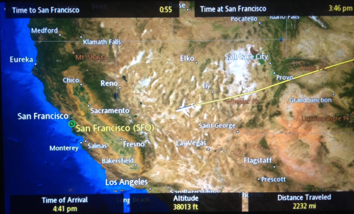
The proliferation of airspace in recent times is well-known. But less scrutinized or contemplated is the value of retaining or communicating a personalized map of the travel of the individual plane across an empty cloud-free sky, as a distillation of the personal experience of flight. The disorientation of these personalized maps consulted above tray tables provides the clearest reminder between snatches of sleep or airplane reading that we are indeed in motion at that very moment, providing a register of distance travelled, height, and arrival time as well, in the upper left-hand corner, time remaining in flight–and the depiction of the magnified presence of a plane over the land that lies contracted below, wildly out of scale with the perspective of the plane that moves across its surface.
Edward St. Aubyn nicely described the odd nature offered by the constant counterpoint of the disembodied relation to maps for passengers faced with the cartographical options of geolocation in rapid-fire succession. If the provision of data seems to revel in informative abundance, the information overload easily loses coherence for many viewers, so carefully crafted are the maps to command attention over the short-term, as if to compensated for the limited attention-spans that is assumed of most airplane passengers. The dizzying disorientation with which the shifting scale of the map, showing a child “their plane hovering near the Irish coast, south of Cork,” suddenly “expanded to show London and Paris and the Bay of Biscay,” only to morph yet again to an “informational feast” that “[at] the next scale included Casablanca and Djibouti and Warsaw” in ways that immediately undermined any comfort of its color-saturated informational content. If airline companies may hope to present to its passengers a form of reassurance, the abundance of maps, apparently exulting in the possibilities of representing a course of transit, and as a result communicated “told you everything except the local time on the plane.” If St. Aubyn sees the superabundance of information on the map as deeply alienating, it is also a reminder of the alienated nature of the in-between space of transit. For one is in an intermediate place in the plane, which remains outrageously magnified on the map, but also outside of it, moving across time zones with the apparent potential of moving to any place on the map, and indeed eventually moving outside its frame, as one shifts among maps that seem to lack any indices, but hurriedly create or improvise a sense of place as long as we are in the air.
With the crowding of the paths of the airways, the itineraries overhead are not only an “informational feast,” but a progressive sense of the unfolding of the flight path that one can watch, while seated, from an empyrean point of view, that is truly satisfying to frame not one’s sense of where one is, but of how much flight time remains. For if the seated passenger is removed from any sense of place, during the course of transit, the map allows one to be a spectator of where one is flying and enlists the most recent mapping graphics to do so, foregrounding the varieties of visual entertainments of map reading while we are in the air compounding the iconography of the cloud cover of a weather map, the remove of the plane from the ground foregrounded by the ridiculously out of scale rendering of the aircraft.

The plane is in a sense part of but not part of the map, a sort of talisman that gives us a sense of direction and markers of distance as we are removed from the earth.

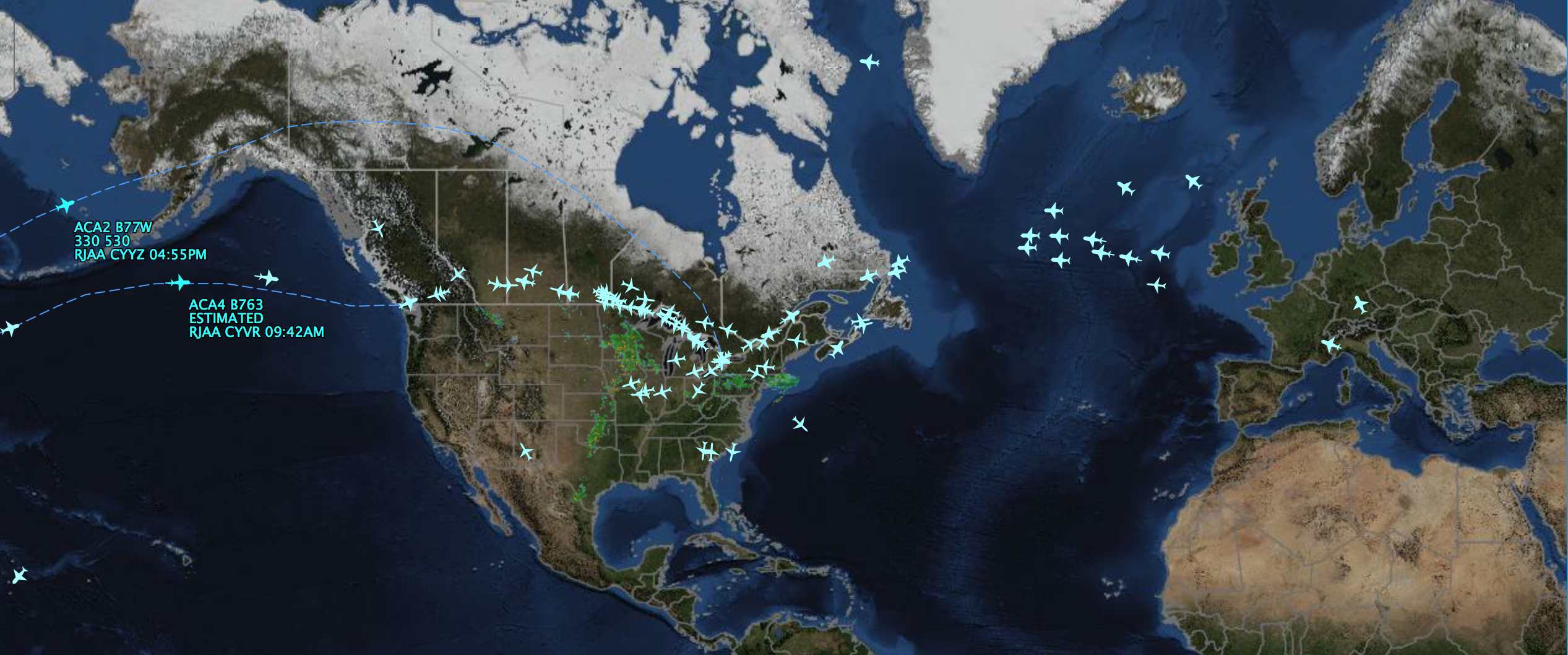
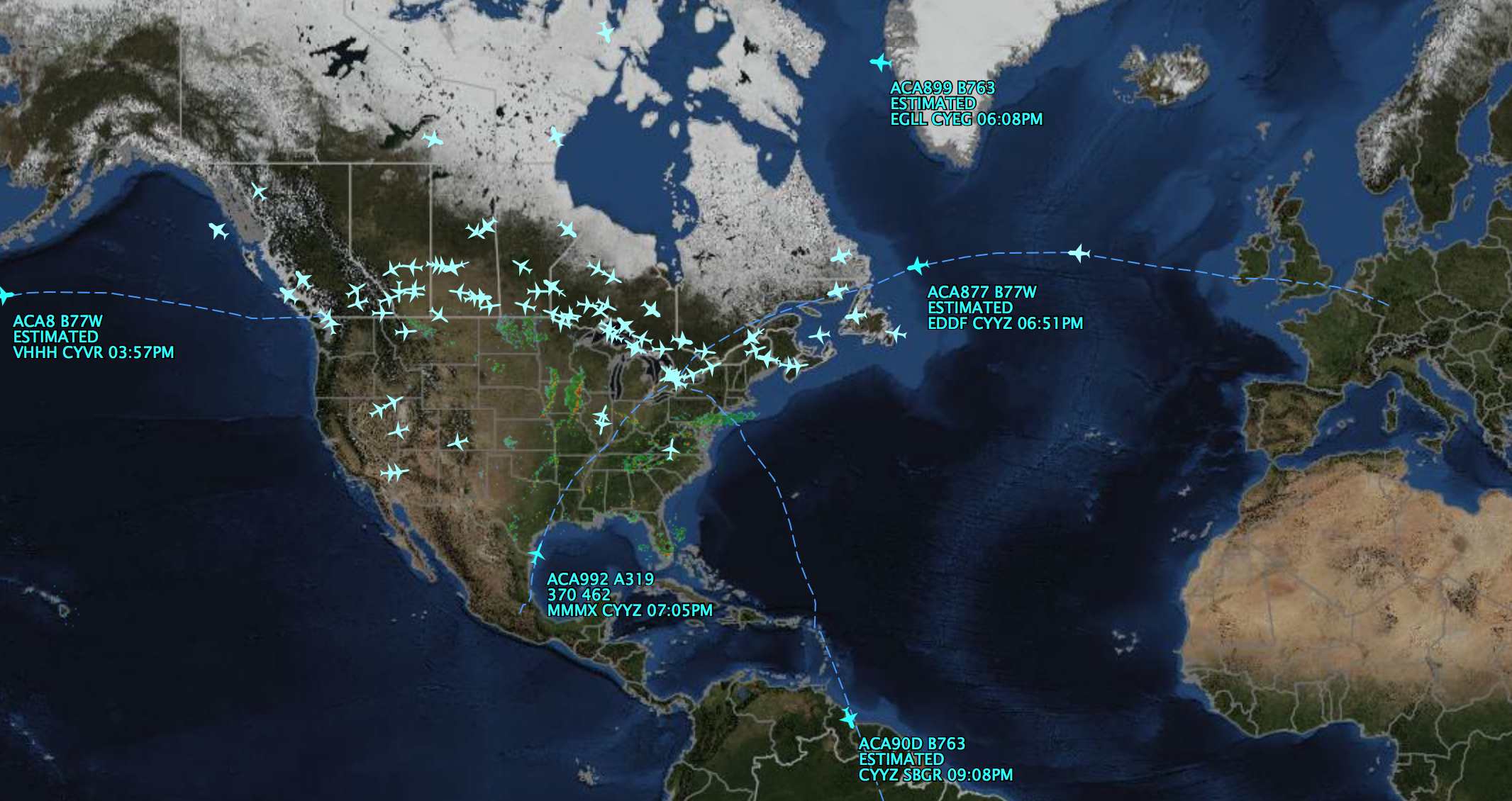
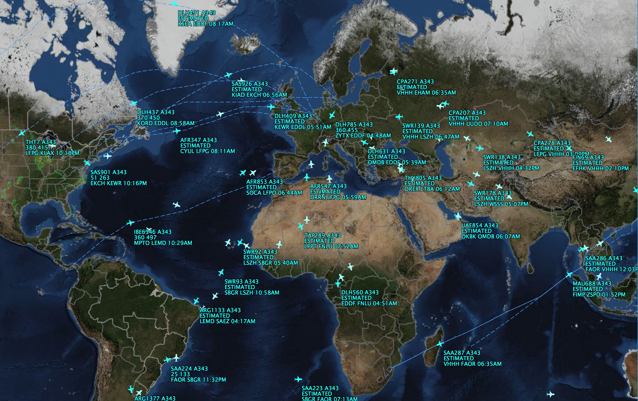
Among the most familiar insistence of the maps we encounter while strapped behind waist-high restraining seat belts, they have been recently marketed as interesting items for home display, as if mementoes for flights taken. We’re far more used to watch them in airports, pondering the possible times of delay or the weather patterns that could scotch a trip or one’s best hopes for one of those multi-airport itineraries. But since 2013–almost an oxymoron–one can not only access on a handheld a worldwide map of all flight delays, or a Flight Aware Misery Map of weather, flight delays, and cancellations across the continental United States, but purchase a personalized printed and beautifully framed 26″ x 29″ one-of-a-kind map of flight itineraries, through a partnership with Sporty’s Pilot Shop, “ideal for office or hangar,” to relive the flights by a sort of symbolic retracing from above of flight paths once taken:
‘
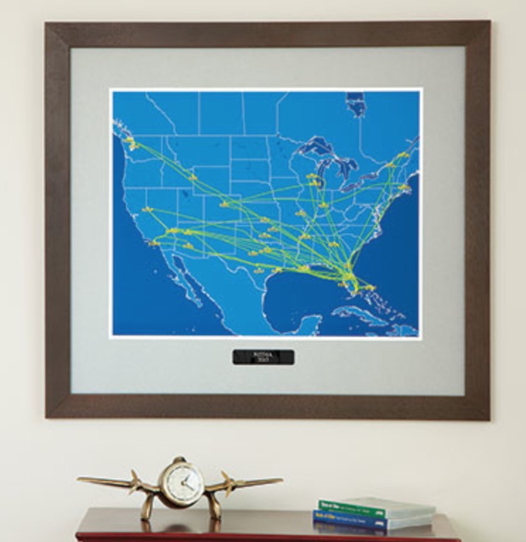
The translation of the iconography of in-flight panels to the framed pictures addresses a select audience. It suggests a new permutation in the work of art in the age of digital reproduction. Its very online availability suggests the expansion of in-flight diagrams and FlightTracker programs as acknowledged areas of graphic design and data visualization, as much as a search for new outlets for our augmented abilities of cartographical transcription. (Perhaps the prime market for such framed mementoes would be airplane pilots, but they are available for the general public.)
The marketing gambit should not be so surprising, given that FlightAware now boasts, as of June 2014, some 4 million registered members, and with its own real-time FlightAware TV, features live maps for HDTV that have inscribed the routes of airplanes onto one’s central nervous system, if not one’s spatial imagination. Indeed, the purchase of the elegantly framed map is perhaps a memento of the in-flight monitor one watched on the trip, or, better yet, of a spree of business trips between January and June of 2013, say, associated with the marketing of a special new product or an investigation of potential shooting locations or trips of birdwatching, in either case providing a neat memento of the miles one clocked that allowed one to gain enough points for that trip to Java. One wonders how many of these maps are sold, or where they are displayed. But the flight-path map is wonderful rehabilitation of that pre-Ptolemaic genre, the itinerary, despite the illusion of the global coverage of in-flight maps: for these maps are charts of an itinerary, that are meant to be read without any needed consultation of the superfluity of accompanying detail they offer. What, if any, is their metageography, save the recursive itineraries across a geographic imaginary? It is hard to say, but it seems to erase or suspend knowledge of learned geography. True, the AirShow maps used by Air Canada include a degree of topographic detail and bathymetric outlines that suggest the importance of geography in school and university curriculum. But the chief end of the mapping is to erase the sort of first-hand knowledge characteristic of classical itineraries, and rehabilitate the itinerary in an abstractly Olympian form that fits the sense-deprived medium of air-travel. One is traveling over, not through, across, around, or beside–not an to show an itinerary of known way posts or recognized landscape markers.
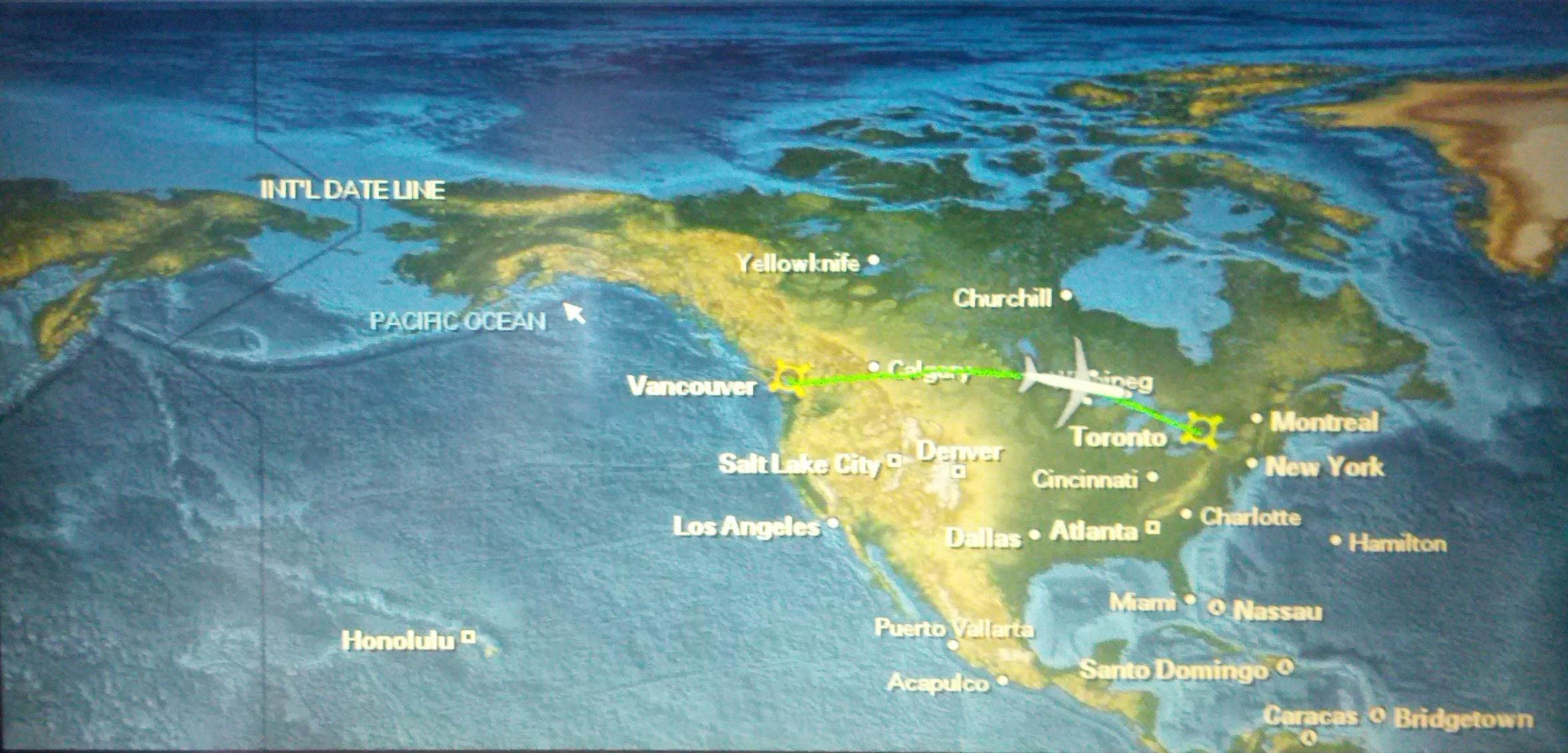
In-flight maps are best responding to the anxiety of “are we there yet?” in an knowingly globalized world, however, and marking a known geography while making little demand for geographic familiarity. The tracking of flights has been greatly improved by Garmin GPS systems, which allow a readily calculated position of the airplane in which one travels above the land. Rather than trace the motion of the plane across a map, however, as one might by reading such framed mementos of flight-paths, the in-flight map on one’s personal monitor. Needless to say, the template of the map most often shifts below the plane–itself stationary as a projected map moves beneath the symbolic glyph–in these maps, which allows the plane to be centered in the visual field of the displayed map, simulating a purely schematic but sufficiently convincing view of the plane’s progress: moving map devices were widely employed before the advent of GPS, based on other methods of determining location; they allowed the option of showing the plane in motion to represent its distance traversed and even elevation. But as the intersecting position lines of a hyperbolic navigation system, GPS allows greater determination of location to represent simulated overhead views of a slew of planes over stationary or moving maps.
But the expansion of versatile in-flight itineraries clearly seems to be in part technologically driven–as, indeed, are much of the return of GPS-based way finding systems–to counter a sense of disorientation with a graphic based on instrumentally measured knowledge. The very certitude of tracking a flight path runs in the face of, and replaces, the maps we hold in our heads of global flows or economic and demographic instability, or social unrest. The expansion of backgrounds to “read” flight itineraries have made huge progress in their relative truth-claims, in a way that often keeps up with the options allowed to be selected on Google Earth, to mimic the LandSat images that provide an illusion of real-time photography of the arcs of flight paths of Air Canada jets, each posed in individual itineraries, like schools of migrating birds or skeins of migrating northern geese, whose routes are readily removed from the terrain, as they in fact positioned in the airspace above it. We are mapping relations not of proximity, indeed, but relations to a fixed destination–at an abstract remove from geography, but reliant on the map to augment its reality effect. We are mapping the reassurance of proximity, and the triumph of aircraft technologies over space, rather than mapping lived space.

Flight Aware’s software designers recognize that there are folks who will continue to appreciate the “Classic” viewing mode to picture flight paths within weather systems, for those habituated to a stark background of aerial flights that recall the rather static monochrome monitors or preferring their stark selectivity, as removed from reality as an airline cabin–this is the very mode illustrated in the map featured as a framed keepsake. There is an undeniable allure o the simplicity and the Olympian supremacy of the in-flight tracing map, if it is not easily understood as an aesthetic marvel.
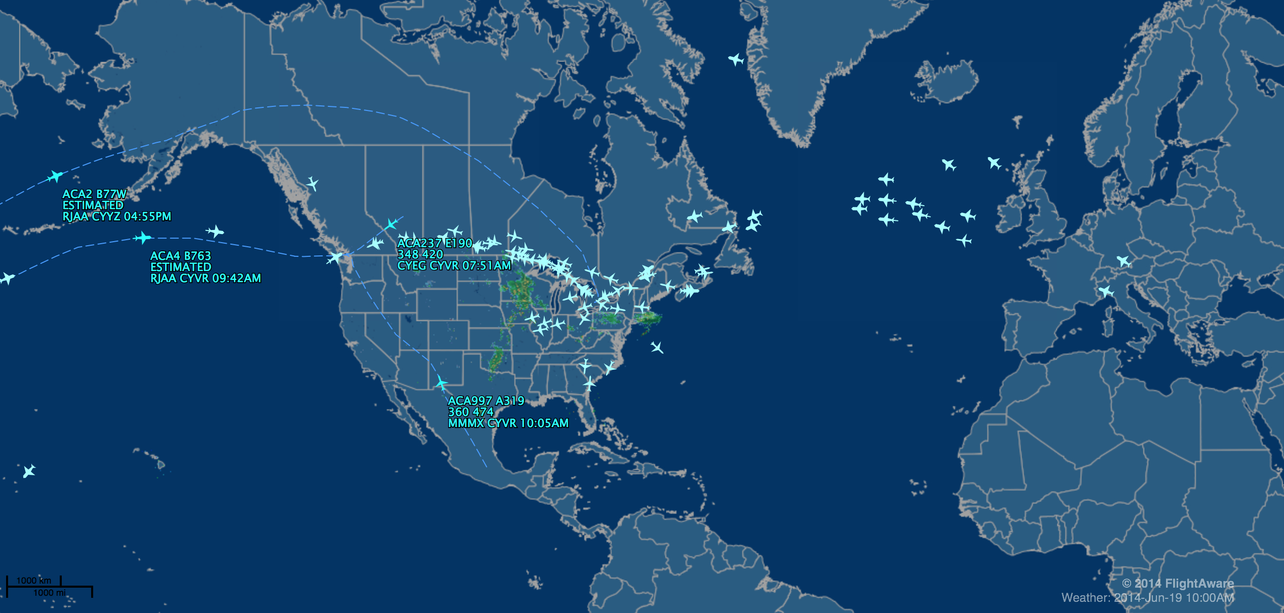
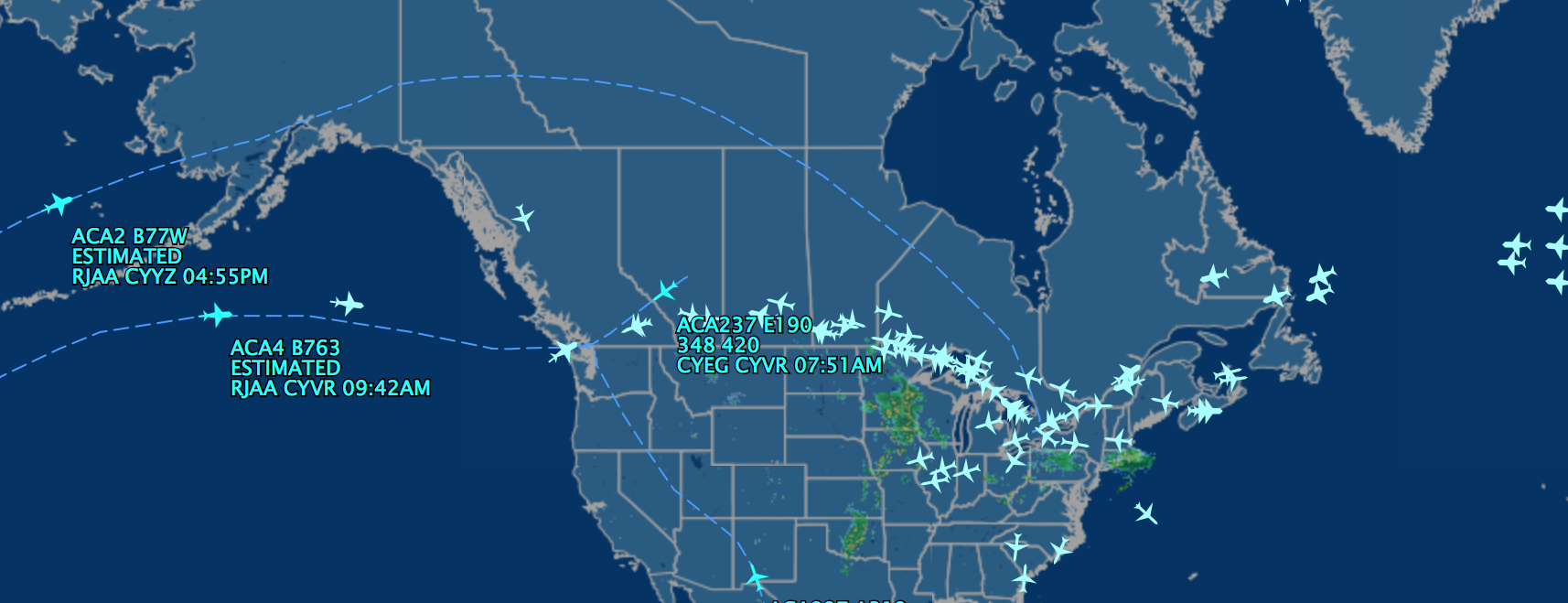
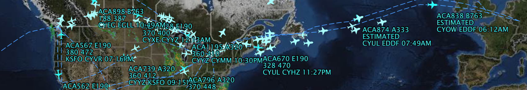
For a company like Air Canada caters to a flight belt between the larger cities above the northern 48, illustrated by the dense trajectories headed to and from Toronto of pixellated air craft so wildly out of scale to the point individual airplanes overlap with each other–but seem convincing to the viewer as an image of individually tracked flights, whose specific itineraries suddenly become apparent as one hovers over each individual aircraft:
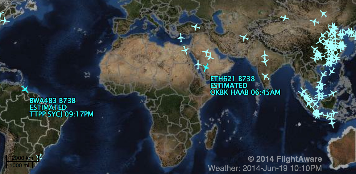
The web of these itineraries are the true subjects beneath the cartographical field–or scrim–on which the planes’ georeferenced global position is projected, and is given the sense of tangible reality that it would otherwise lack. Despite the availability of two viewing modes, the optative mode of viewing in Earth Mode, transcribed in real time, placed against a glorious Google Earth-type view, features a superfluity of cartographical detail in its suggestion of oceanic depths and the mapping the fastly receding polar ice-sheets, saturated with far more detail than their users would need, complete with weather conditions and cloud fronts:

There is a clear attempt to create a more meaningful connection to the image in the map by increasing the amount of local detail in its surface. What else can explain the pleasure afforded by the super-abundance of cartographical data included in the in-flight map one sees on a flight over Thunder Bay, beyond the increased geographical literacy of many Canadian passengers? There is something suspect in the bucolic view of the landscape over which we travel.
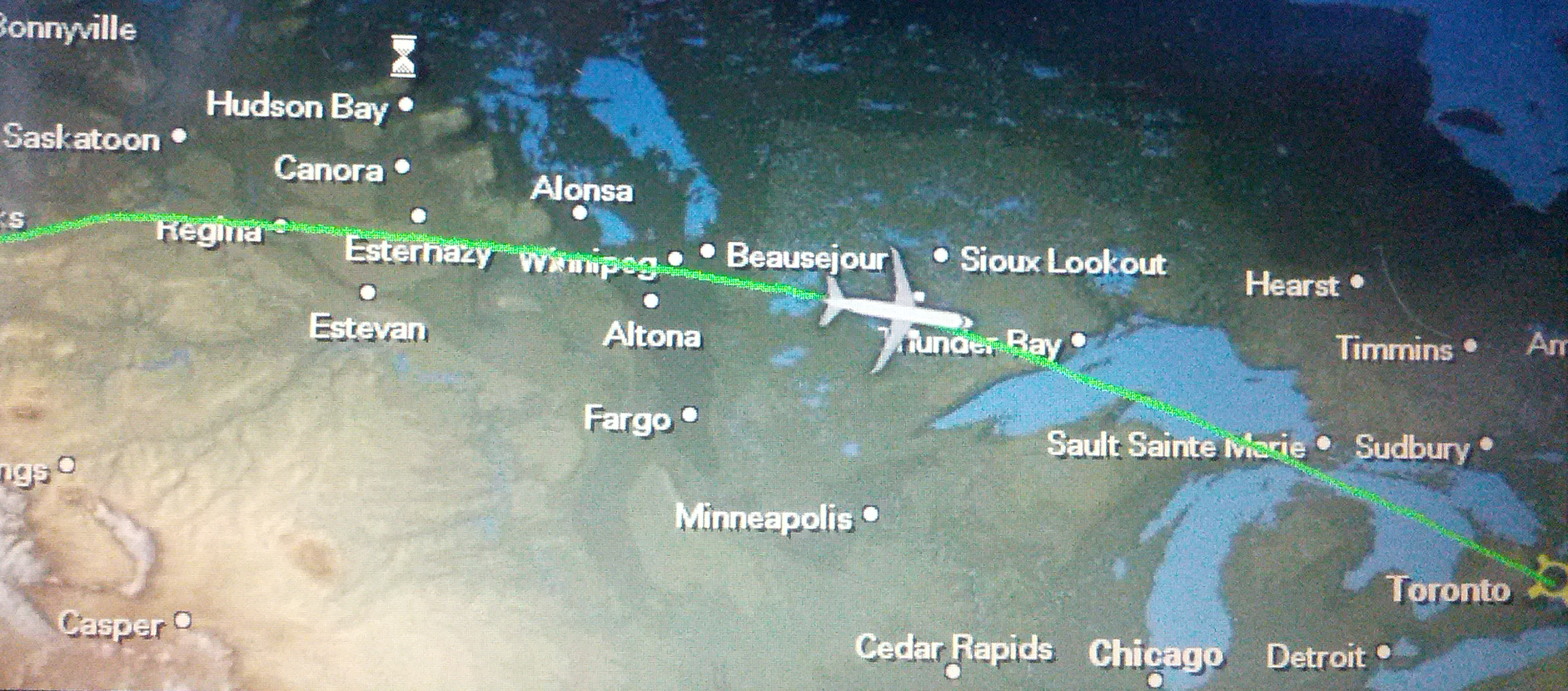
What can explain the huge interest in innovating new coverage in this genre of map, if not the ubiquity of charting locations on a smart phone, that pocket-sized pathfinder that seems designed to purify our personal relations to the messy processes of globalization, and the need to offer an even more detailed and compelling view of one’s flight en route to one’s destination? With the increased ease of creating and tracking global positions in such maps of airplane flights, some “moving map” devices even include an option for allowing the chart to remain stationary, and position the progress of the individual airplane within the map, and even, in some versions, note specific changes in altitude. When hovering over the tracking map, estimated times of arrival materialize beside each flight path. When viewing the in-flight map en route, there is even a greater abundance of landscape, detailed as if to convey a sense of awe at the arcing over the continental in a truly transcendent voyage:
The wildly out-of-scale iconography can sometimes get messy in flight-tracking maps: the problems of overcrowding of flights that may result from the software–or reduced screen size of the monitor–are slightly absurd, due to the density of the sine curve of flight paths used by Air Canada.
oir the density of Boeing 737-800s in one part of the world, where they seemed parked for refueling–all rendered all the more meaningless given the lack of their individual flight paths:
But they also can suggest a map of something like a counter-map of global interconnectivity, if we look at the FlightAware map of flying Airbus 340-300’s across the globe, weaving a web of the virtual trajectories of the Airbus flight paths that link (or wrap) the pristine world below, one that triumphantly heralds the achievement and onward march of globalization in its not-so hidden narrative:
Surely part of the pleasure of these maps from imagined high altitudes is how they take our eyes off the divisions on the ground below, and ask us to focus on the itineraries in the skies and on the airborne destinations to which they carry us. Part of their pleasure lies in how decontextualized and how stripped of specific meanings they actually are. Part of the personal appeal that these maps have lies in how their infinite itineraries run against (or cut across) the notions of embodiment we associate with maps.
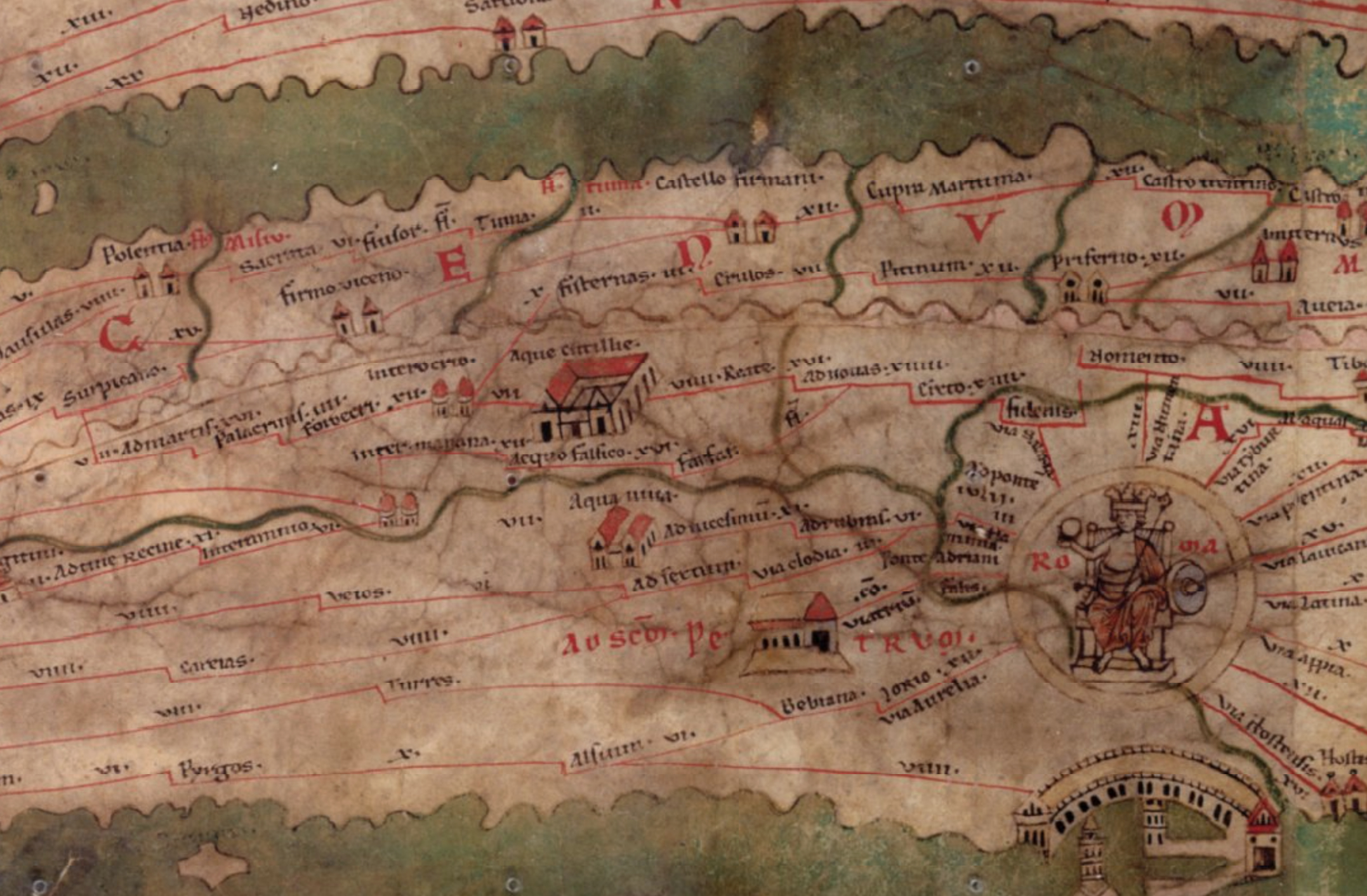
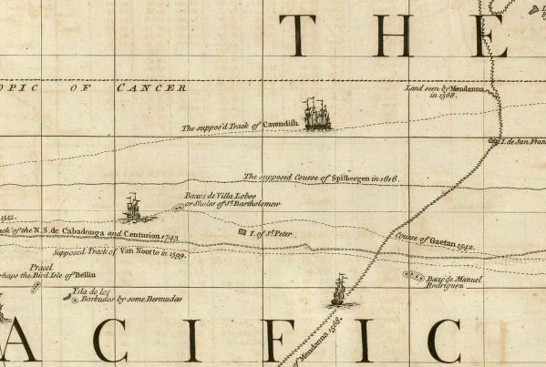
In so doing, they take our eyes off of the costs of gas consumption or air pollution of multiple flights, tracing a course above the surface of the map itself, somewhat in the manner of an eighteenth-century chart of navigational routes noted the timetables of Pacific and Atlantic travel–where courses of the instances of known travel of remembered expeditions were rendered and recounted in short textual vignettes beside frigates’ courses.
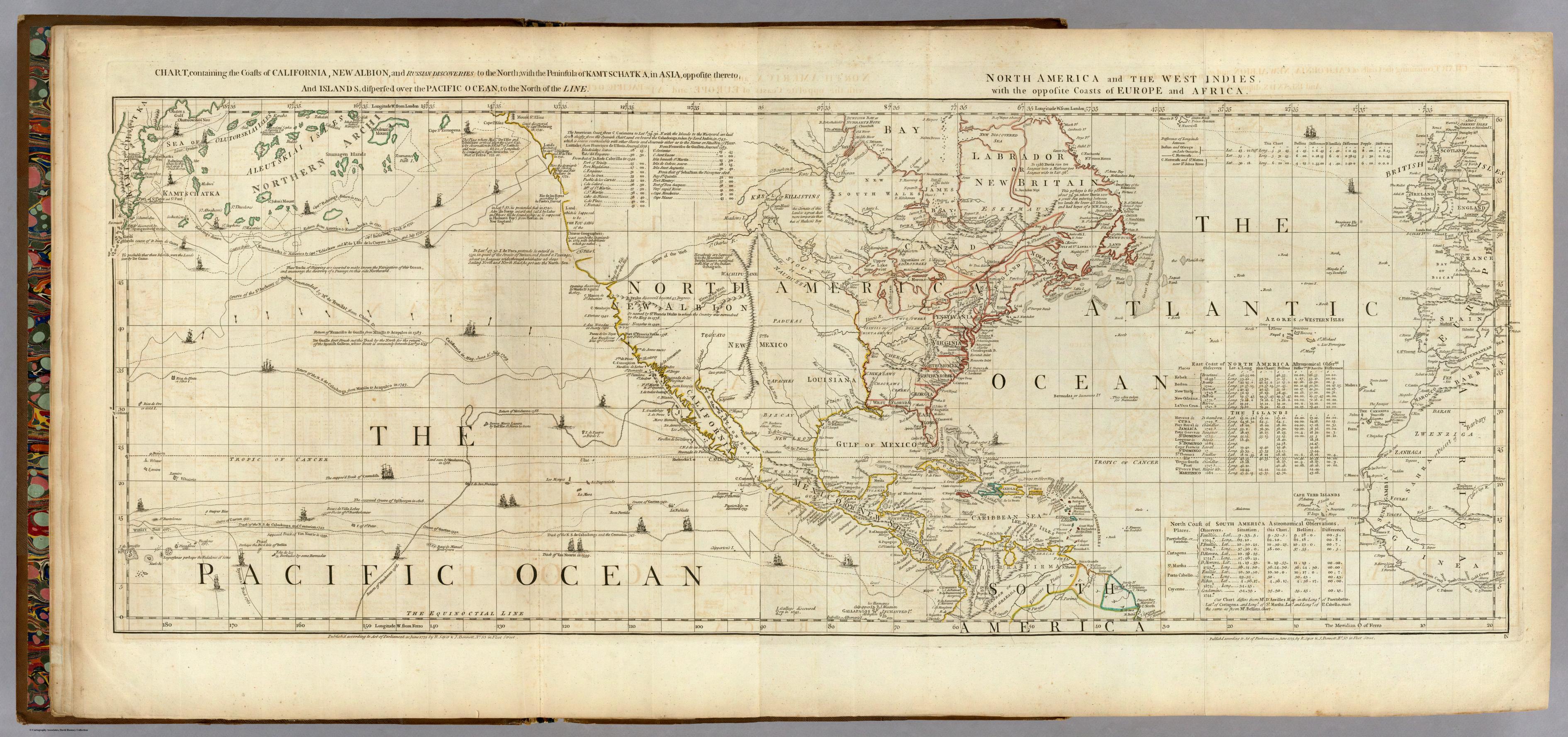
Unlike this 1775 sailing chart, engraved in London just prior to the Declaration of Independence, privileging paths of nautical navigation to the Americas far above the landmass’ interior, as if for future speculators, the in-flight maps made for airline corporations bear analogous traces of their commercial provenance by what they shift our attention from: we almost forget that these flight-tracking maps, if admittedly made for one demonstrative or persuasive end of showing time to arrival, omit and mask the continued atmospheric costs of continuing such an access of multiple destinations by air travel–or the gasses and pollution emitted from said flights. The Institute of Public Policy Research has found that airplane flights–including military and commercial travel–are not only “the least environmentally sustainable way to travel and transport goods” but one of the most dangerous, given. Our airports are the largest polluters of nitrous oxide of whatever city in which they are located, and, more to the point, flights deposit dangerously concentrate greenhouse gases in the upper atmosphere–and air traffic is predicted to grow ten times by 2050.
For the aircraft that travel on these itineraries pump out carbon dioxide and other greenhouse gases, of which they already constitute some 4% of global greenhouse gasses, according to the Intergovernmental Panel on Climate Change, and emit toxic gases deposited at the highest elevations in the stratosphere, leaving greatest damage because they will remain twice as long in the atmosphere, and be far more destructive of the earth’s ozone layer. What isn’t mapped in the itineraries, oddly, is precisely the known costs of making the flights, or the deeper impact the proliferation of apparently innocent lines of air travel on our planet’s atmosphere–revealed in part in the map of NO2 tropospheric density pictured below.


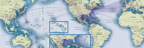
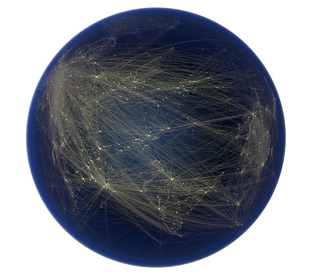
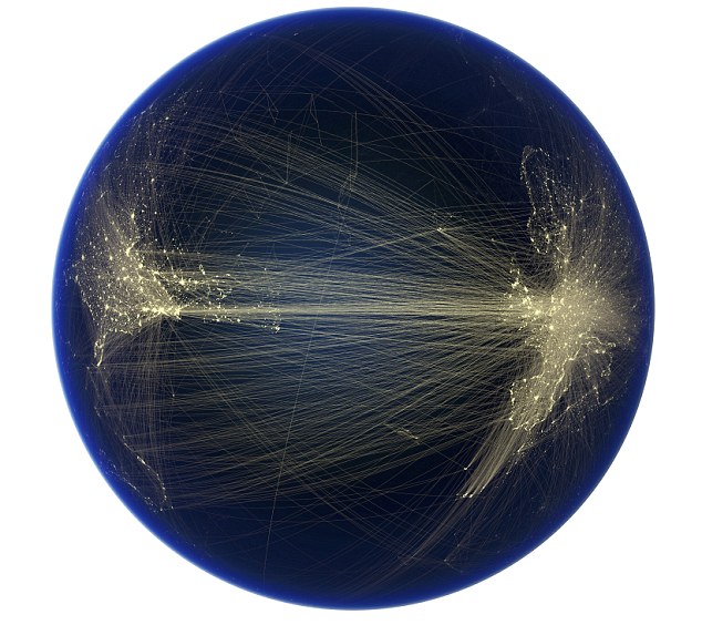
As of only 2011, the global traffic of planes both parked, taxiing and in flight appears as numerous flies crowding around our centers of population, almost as if to crowd out the idea of embodying a record of inhabited land. Is this a metaphor to the international fostering of a proliferation of airports on the ground that define our new sense of destinations (and networks) and the crowded color-coded traffic of airplanes in the skies, shown one mid-afternoon, as if buzzing over the prime points of arrival and departure in our new “known” world:

Felix Pharand Duchesnes, director of Globaia, more recently used his desktop computer to map a global web of flight data available online by links hubs of air travel. Duchesnes sought to market a clear graphic of the shifting knowledge about the world, and one of the most striking of his dozen “maps” of how humans have changed or created new knowledge about the world was to map the density of air travel in order better to visualize the extent to which we are impacting our planet on a global scale. The abstractly rendered lines of air travel traced between illuminated dots not only connect destinations and points of arrival, but offer a purified sort of spatial imaginary: they are an icon of a process of globalization that denies borders or boundary lines, tariffs, and other impediments to interconnectedness such s economic zones of protection. The image performs the reverse operation of embodiment that one is habituated to gain from a map: rather than embodying regions, crisscrossed routes disembody knowledge from an embodied ecumene: one sees only destinations and starting points and entrepôt, rather than territorial or terrestrial continuity.
Is this model of inscription the sort of mapping that an increasingly airborne economy has come to deserve?


Mercator Projection, indeed all “rectangular” map projections are a poor choice for mapping a flight path in real time. For a more correct spacial representation of distances and directions, a half globe orthographic view centred on the aircraft is much preferred. This is even more so the further away from the equator a flight path goes.