
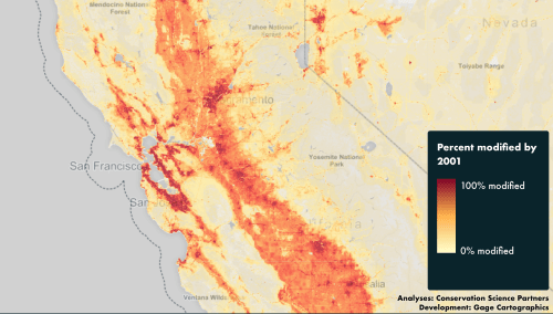
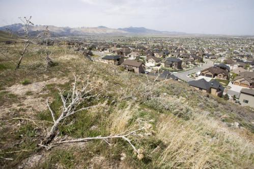
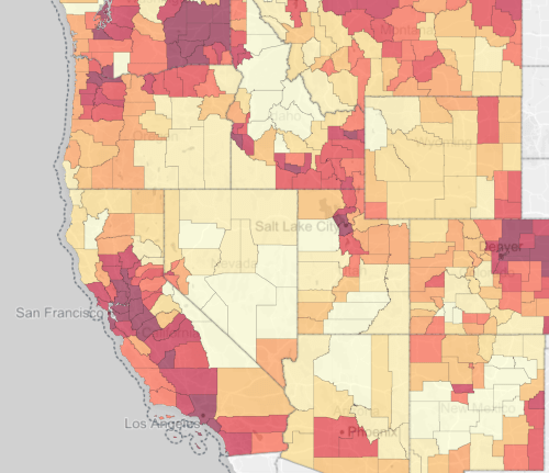
In the visualization of land conversion map in the header to this post, cities like Denver, San Francisco, and Salt Lake City haunt the transformation of landcover across the western United States, as the place-names haunt the five-color map that denote the scope of an absence of open space. From each city, expanses of red leach into the landscape, spreading outwards along patterns of settlement in ways that seem to infect the adjoining counties to register how development cascades to surrounding regions. The image shows the reduction of once-open spaces with the dramatic pace of extra-urban expansion in most western states, whose absence seems to haunt the region that we once knew as the American West, and are departed from it.
The dynamic maps suggest a poetics of loss, both qualitatively objective and evocative of the disappearance of a landscape that no longer exists. Increasingly elegant interactive data visualizations help orient viewers to a changed relation to the landscape of the west over the past twenty years, and the disappearance of what was once a notion of wilderness that have so dramatically retreated over increasingly active real estate markets and dynamics of expansion that allowed such pronounced extra-urban growth over a short period of time. The subject of the maps is not only difficult to process, but complex to navigate over time: if the use of a slider bar helps orient oneself, it also raises question of the historical implications of such a broad retreat of open spaces across western states. If the Old West seems a fixed chronotype to some, it may be that mapping the retreat of open spaces can provide a lens to chose our Romantics, or map the nature of our Romantic tie to the retreating spaces of the past and its landscapes.
But how best to read the landscape that lies beneath them, and the changed experience of the landscape they seek to describe? The stark colors of the data visualization cannot but suggest a romantic relation to place, marked by the disappearance of formerly open lands, and suggestive of a deep change over few years. The multiple levels of time that the maps of The Disappearing West, a web-based map offering ultiple datasets of different sorts of human activity presented by Conservation Science Partners and the Center for American Progress. The elegantly interactive website of land use, showing incursions of open spaces in alarmist red, provide a way to take stock of existing changes and the dizzying pace of the disappearance of opens spaces that may even be cognitively helpful, as the scale of such changes are so difficult to process. The opportunity to examine change on different scales and over time, by use of a slider bar, provide a basis for coming to terms with the increasingly irrevocable rapidity of such changes, and indeed with the inevitable melancholy of the departure of the known world of the past, but provide a deep and irrevocable sense of how our own ability to observe the western landscape is in the process of irrevocable change.
1. Such a sense of irrevocable change was quite violently tried to be stopped when the self-designated cowboy when the out-of-state vigilante Ammon Bundy summoned like-minded ranchers who inhabit another region of the same landscape in Nevada. He summoned the ranchers who viewed themselves as rightful residents of a faded land so that they could seize public lands in Oregon’s Malheur Wildlife Refuge, without justification, but to assert their imagined rights to open lands. In garrisoning one outpost of the wildlife sanctuary, without much regards to its use, they sought to stake claims to their rights to a rapidly departing map. Their reaction–but one of many to the disappearing west–suggest a point of beginning to see how we might better come to terms with the acceleration of the loss of open spaces over time, and the problems of mapping them onto the region’s powerful spatial imaginary.
For in misguidedly hoping to occupy the refuge’s offices until the United States government “release” any claims to the public lands it has long administered, they seemed to act in hopes to reclaim a landscape increasingly fragmented by overdevelopment and forever altered. As open spaces of the Old West disappear, the staying power of the mental imaginary of open lands have created a tension palpable enough for Bundy and his followers to view federal protection of pubic lands as unjust, and armed with a sense of reclaiming a lost landscape for hunting, they aggressively reclaimed a myth of a sacred relation to the land that they might experience to use firearms freely without impunity in open spaces, and eager to recast protections of public lands as if they were primarily individual restrains.
As if to stage claims to a disappearing west, Bundy sought to reclaim them for ranching and hunting from a very local point of view, resisting a disappearance of the fabled “open lands” that once defined the imaginary of the West for Ammon Bundy, the son of a Nevada rancher. Bundy and his fellows railed against the government, invoking hopes to restore the conditions of the west, as if removing governmental presence would let a wilderness reserve to revert to wilderness by liberating it from alleged government control: his anti-government animus was evident in his earlier defense of the right of his father, Nevada rancher Cliven, to refuse to pay grazing fees of federal lands. Ammon encouraged a 41-day armed occupation of Oregon’s Malheur National Wildlife Refuge in January, 2016 to defend local claims on a national stage–although his anti-government stance was more apparent than his appreciation for the historical loss of open lands across the extent of the western states.
The outpouring of sympathy of resistance of a range of militia to Bundy’s elaborately staged reclaiming the West was a response to a shifting mental geography of the west. But the bizarrely misplaced response of such extreme violence among the Bundy and their followers in the name of reclaiming western lands seemed to act as if it was possible to restore it to a lost landscape of hunting, trapping, cattle ranching seems a geographic dream. If the maps were in their heads, it was so remote from realization to be self-indulgent. Might the interactive format of a web-based map provide a more clear-eyed way of taking account of the rapid decline of open lands across the western United States? Can interactive data mapping of California’s rapid loss of open lands in an interactive format provide a more clear-eyed ability to track their disappearance?
A recent set of two-decade old change in The Disappearing West offer an opportunity to assemble and investigate data on the drastic reduction of public lands and extent of extra-urban growth across the west that seems particularly timely as a way to chart the rapid pace of landcover change in the West in relation to the Bundy brothers’ ill-conceived attempt to the back a mythic relation to the land. The graphic tools it offers call attention to the loss of open lands in our national interior. Indeed, the increased current dangers of dismantling the public custody of remaining open lands may make the website a valuable tool of visualizing and taking stock of the extent of their reduction in recent years–and raise questions about the best ways for preventing their disappearance.
For the dangers to the western lands lie in fact less with the invasiveness of public governments or the extent of government land-holding in western states than the true value of their custodial role in preserving needed habitat and open spaces–the commons of the wilderness, if you will–that are increasingly endangered or lost. The imagined spatial geography that the Bundy clan sought to defend has long vanished, but Ammon and his brother Ryan held a spatial imaginary nourished in a landscape where federal policy, rather than local development, threatens the landscape of the west. Much as their father, Cliven, had evoked the former freedom of a once open lands of the western states once known as the “public domain,” the retaking of a federal wildlife reserve seemed a theatrical reenactment of federal lands as if a wildlife refuge constituted a last stand for defending his family’s rights.
The vigilante group illegally occupied offices of a preserve for birds for month, after intending to remain for a year. They did so in their desire to affirm a departed west, but acted somewhere between a costume party and organized terrorism in a poorly conceived defense of the Second Amendment, dressed in cowboy hats and attracting the support of anti-government militias at whose rallies Ammon Bundy and his brother Ryan announced plans to occupy the refuge’s unoccupied offices on the first days of 2016, inviting armed men to sieze them to defend the idea of access to an idea of wilderness long vanished for most. The range of objects sent to them–many including sex toys that made fun of staging claims to masculinity in an isolated cabin–underscored the futility of hoping for a restoration of a rancher’s sense of the wild, by hopes to “open’ 1.4 million acres of the National Forest for logging, conjuring specters of governmental presence in untarnished lands to protest the government’s role in the US West. Their bid to renew the old rules of the western lands by exposing an undeveloped forest to forestry, challenging how the National Parks have preserved remaining isolated areas of a once-forested expanse of wilderness, suggest the need to gain purchase on the scale of the expansion of paved landcover and property development across the western United States.
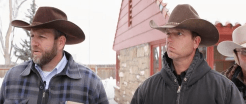 Ammon and Ryan Bundy/Oregon Public Broadcasting
While their protests were misguided, the Bundy brothers seized state facilities as if they were their natural rights, bulldozing new roads in the refuge, and attracting the attention and support of local libertarian militia until they were arrested as if protesting the death of an earlier rural America and of the once-open west through the issue of federal land-ownership. But the problems of public management of lands have little to do with the disappearance of open spaces across the western United States, if the Bundys sought to defend their ability to graze animals, hunt, camp and live in open lands increasingly curtailed in most of the United States, and even in the western states where few opens spaces remain, but where residents were long attracted to the freedom of their open space and ready to defend what they saw as the impending encroachment on common lands, and lacked much objective relation to the deep exclusion that they felt.
 Rick Bowmer/AP
2. The loss of open spaces from Arizona to Oregon are far less the result of government policies than the rapid overdevelopment of western lands, and although the spatial imaginary of the Bundy and his followers directed much of their animus to the United States government, they responded to the rapid contraction of the notion of “public lands” that have changed the very image of open space across the western states, which Bundy seems only to understand–quite misguidedly–in terms of the federal policies of land management. If the notion of “the commons” has long departed from the American West, the image of those commons and rolling plains has been far more compromised and challenged by the rapidity of land conversion due to public development and the rapidity of extra-urban growth, which Bundy from the perspective of his father’s ranch may not see–and may even only be able to be entertained from a site such as the Wildlife Refuge where he and his followers holed up and presented the demand that the “federal government will relinquish such control” of the national forest it maintains in a role of stewardship, and allow “ranchers . . . kicked out of the area [to] come back and reclaim their land.”
The imagined intergenerational transmission of property rights in regions never open for ranching could be alleged to be “in accordance with the [U.S.] Constitution, which is the supreme law of the land,” but the desperate vigilante action was a power-play for national attention with little sustainable logic–especially given the scale at which open lands were lost to private development across the west. Whether the image of the “Oregon Territory” inspired Bundy and his crew, privately held lands (light blue) dominate Oregon far more than the small bits of National Wildlife Refuge (brown) lying in Eastern Oregon–yet Bundy alleged his case lies outside of government jurisdiction, summoning a misguided notion of natural rights to defend his personal right to the land.
 Land Ownership in Oregon/Mark Green
3. The accelerated diminishing of green space across much of the Western United States has rapidly rewritten a landscape of once-open lands. Such rapid curtailing of open spaces, as much as revealing a change in land cover, has deeply altered the local experience of the very landscape and fragmented wildlife habitat in ways challenging to map-so radically have deep changes altered our experience of its landscape on the once-virgin west through the rapid change of once-rural lands. With over a hundred million acres lost to modification by humans, a decade of satellite imagery of land cover over eleven western states, the interactive maps The Disappearing West offer a starting point to explore, survey and take stock of the scale of massive environmental changes created by an ongoing collective redefinition of how we have come to inhabit the new landscape of the American west. Indeed the interactive timeline tracking urban expansion and landcover change offers a different ethic relation to how land ownership has led to the dramatic curtailment of formerly open space.
The progressive development of the landscape over a decade is difficult to comprehend. But the streaming of this data into multiple layers, superimposed on each state, counties, and urban areas allows foregrounded layers of the map to jump out at viewers in particularly effective ways. They help parse the eleven western states that fills 165,000 square miles of landscape–a change in land cover equal to the construction of parking lots for six million superstores, and at an annual rate of an area almost as great as the footprint of the entire metropolitan area of Los Angeles–and far greater than the footprint of New York City, according to US Census records of the loss of natural lands used by Conservation Science Partners–to create a virtual profile of land conversion in an area that is increasingly fragmented by road, as once roadless areas are exposed to development. The rapid nature of such anthropogenic change has been to some overshadowed by intensity of drought and of global warming, but distances the land in a terrifyingly definitive way as the region’s open spaces are increasingly segmented by roads and transportation routes. But it has brought a fragmentation of open landscapes, driven by the expansion of roadways, overdevelopment and competition for limited resources, that have parcellized whatever protected open lands indeed remain.
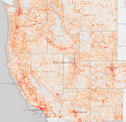
The web maps focus on a uniquely revealing index of the human footprint, rather than cities, or jurisdictional lines, to suggest the extent of how we are re-writing a relation to the land. They aim to comprehend the loss of land over time a region that is reduced by a football field of uninhabited lands every 2.5 minutes. The map is an attempt to depict the scale of this vanishing landscape, by a detailed record of the scale of the contraction of open lands that one can zoom to local levels, against which cities and regional names float in ghostly way, as if it describes the changes that underly a simple road map of place-names and individual states.
How can we read this record of disappearing space, save as the emergence of a new set of attitudes to the land? Its flexibility helps take stock of accelerated changes in ways that we have only begun to take stock collectively; the maps force us to come to terms with the scale of recent “development” of open lands in ways that have been rarely so effectively or dramatically synthesized in one site, and our increased power to comprehend and try to come to terms with the disappearance of an older landscape that was the focus of such romantic attachment,–and the rate of the recession of that imagined past.
The visualization that can be examined over time and in such striking local detail affords a basis for imagining the terrifying scale of anthropogenic change across the west, with all its attendant problems of wildlife conservation.
The idolized aspect of a map as a “world/ not of this world” was described by Polish poet Wisława Szymborska, The poem evokes the world as it was once inhabited, if not providing a space to preserve that sense of loss that the human mind retains. If the map can “give no access to the vicious truth,” for Szymborska, the web maps in The Disappearing West try to provide an access to the sheer truth of the speed of land transformation and groundcover change. The interactive maps expose the degradation created by the scale of its inhabitation–and the vanishing of once open space at a pace equal to the construction of six million superstores in once-Virgin land. Is the Bundy case of the Malheur Refuge a misguided reaction to the disappearance of such once-public lands from the map? How to map or take measure of the alarmingly rapid shrinking of open lands is difficult and challenging to render. In part, this is only because the scale and rate of their disappearance has been so rapid: the disappearance of the open west has, however, become something of a paradigm for the loss of space.
The loss of open lands in the region is especially important to map in comparison to the rest of the United States in an era of increased severity of drought–if only to take stock of the shifting patterns of land management that have led to such a massive transformation of the lived landscape. The multiple scales and avenues for exploring and assessing the contraction of open space across the western United States. In the Disappearing West, interactive maps trace the changed landscape from 2001 to 2011 that invite observation at multiple scales. The richly-colored web maps try to grasp and appreciate the vast scale at which the conversion of once-open spaces across the western United States over a decade, and the stark remove of the past. The interactive synthesis of levels of development and extra-urban growth help take stock of the tremendous loss of open lands in states, counties, and localities over a decade, each now trackable over time by an interactive slider bar for easy investigation.
The interface with the disappearance of public lands puts one in touch with the departure of the very sort of landscape which motivated Bundy and his friends to imagine they might recover or restore by occupying a wilderness refuge with their guns: sense of navigating an accelerated virtual record of the changing landscape of the west communicates the rapid loss of lands to development traces the extent of lost open spaces difficult to imagine at any scale. They focus not only on land cover, but the disappearance of the open spaces that were once thought of as open lands. Although we can map multiple indices of human impact as being predominantly agricultural, the disappearance of lands to private land development paints a picture of the curtailing of landscapes once thought as innate to the region. The dramatic scope of anthropogenic change is as immense as in the expansion of intrusive sound-levels of human-made noise across lived environment and national parks, or the diminution of sounds of species that remain in undeveloped western lands.
The loss of such open spaces are the natural corollary to these anthropogenic shifts–but offer an even more acute register of the loss of once-“natural” habitats in which a range of birds, grazing animals, and insects dwelled, and the transformation of land cover that development has wrought. While strictly analytic as a parsing of a large datasets, the striking color schemes of these web maps raise multiple alarms about the changing land cover of the west and the new landscapes that we increasingly have come to inhabit in a formerly Virgin West. The change in land cover across the West is challenging to map comprehensively and in adequate detail to convey the change in landscape that has occurred. A compelling visual synthesis of the massive contraction of open spaces over a large area maps the loss of wilderness due to increasing development–largely on private lands–by directing attention to the changing of the landscape of the west, by synthesizing a range of data on the conversion of open lands.
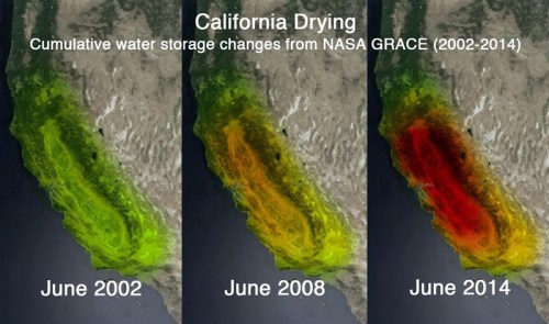
The role of the accelerated pace of human impact on the lands of western states has so rewritten the landscape that maps are useful to take stock of the incredible pace of loss: i the map below, the percentages of lost lands are projected on the landscape over a third of the country, as the fragmenting of open spaces proceeded from 2001 to 2011, and the drastic diminution of open lands grew with the expansion on and development of private lands. This development of once-open spaces across the West has mapped a deep transformation present across the memory of a generation. At the same time as much of the region was altered by drought, the transformation by construction of private homes outweighs the changes caused by agriculture. Sadly, the pace of development of open spaces over the past two decades is especially tragic since in much of California’s regions and especially its Central Valley they parallel the decline of water storage in due to drought, as declining groundwater availability–California’s Central Valley alone has swiftly lost some 4 trillion gallons of water annually in recent years, dramatically changing the distribution of water storage since 2002 made clear by color-enhanced composite pictures, based on data registered by NASA’s Gravity Recover and Climate Experiment Satellites–
Mapping drought may offer as compelling and arresting picture than the increased overbuilding of the landscape’s open spaces, but the conversion of open landscape create a particularly unforeseen and tragic combination of circumstances. There have been many attempts to map the transformation of the west at adequate scale, but rarely with such neatness in delineating the change in landscape over time. The decline of the “commons” or of public spaces of wilderness maps register a changed place over ten years has redefined the twelve states we know as the American West, where building has grown at such a massive clip. In an iconography that recalls climate change, the increasing loss of open spaces suggests not only a landscape of increased fragmentation, but a decrease in carbon sequestration, and a contrasting image to the 2007 Western Land Cover Database‘s far more restricted image of developed lands–colored below in bright red, in a landscape that is dominated by deciduous forests (light green) and evergreen (dark green)–and presents a verdant landscape of pines, albeit in a frozen PDF that prevents close-up observation. The above map, based on satellite-based remote sensing of the spatial boundaries of ecosystems, notes disturbances by carbon production, rather than agricultural modification, to assess future potentials of carbon storage and sequestration in a period of climate change.
Most land-cover maps barely succeed at registering the scale of such change or its pace–they far less dextrously render so great a range of datasets into easily legible terms.
 National Land Cover Database (2007)/Zhu, Sleeter, Griffith, Stackpoole, Hawker and Bergamaschi
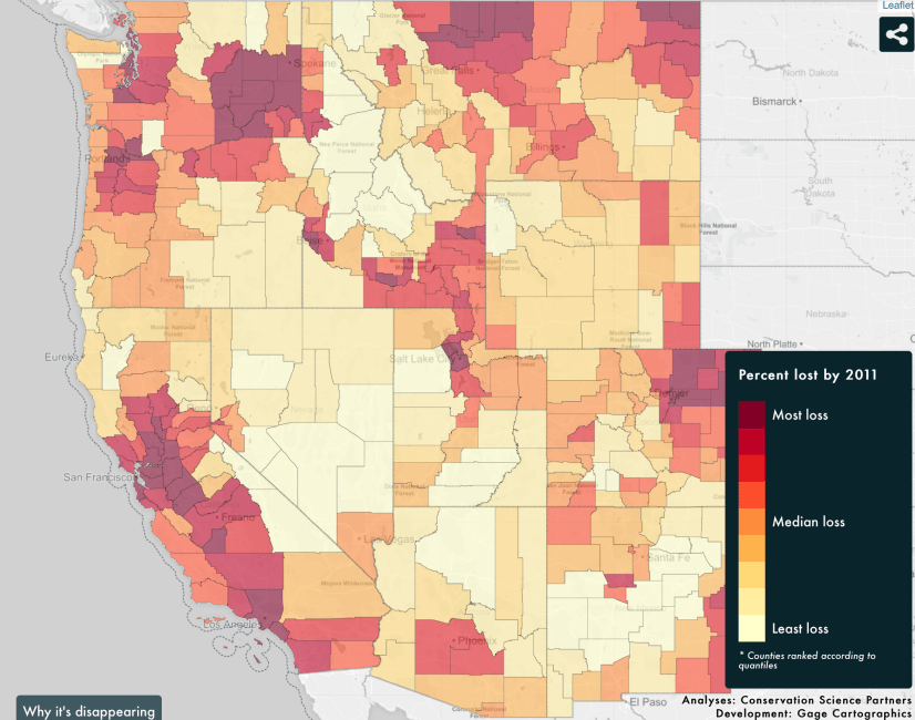
The accelerating reduction of open space across the West over generational memory can now be examined and evaluated in striking detail in the layers of the interactive map of relative losses of lands across the eleven western states from 2001 to 2011. The web maps, synthesized data on the loss of open spaces over time at multiple scales, offer a basis to place oneself in the changing landscape of the western states over time; interactive viewing almost simulates an ability to enter the landscape that it maps. Viewed county-by-county, it reveals regions of sharp degradation, and a concentration of a loss of lands around regions of extra-urban growth, from which one can also examine at significantly higher resolution to look at local impact at a scale of up to thirty meters–providing a neat register to toggle between three datasets. When paired with a slider bars to examine the contraction of open spaces and land conversion over years, the map parses data on different scales to chart a contraction of open spaces that help one come to terms with a massive level of landscape change and the scope of widespread degradation–and force us to terms with its consequences by inviting us to drill deep into real indices of actual landscape change.

By shifting scales to view regions of increased loss of open lands provides a snapshot of development across the west–based, for sure, in California, but equally afflicting Washington, Utah, New Mexico and Colorado in a spate of conversion of what were once open lands, we drill into new layers of data on the loss of open lands that is so difficult to be objectively seen.
4. The changing nature of the human landscape many have received far less attention than climate change and rising temperatures, but has long proved especially difficult to grapple, as the combination of increasing construction of suburban plots to create rapidly expanding extra-urban areas conspires with the search for new energy sources to radically transform what once was considered wilderness, or the open spaces that defined the western United States. Private development of land across the west suggests not only the dangers of the decline of “public lands” across the west–at odds with mappings of the myth of the dangers of federal land ownership in western states, which a neat map argues define the region, condensing the total federally owned acreage to stretches of bright red, symbolically rendered not too subtly as calls for attention or as parasites incubating within each state. A chart that sought to privilege the intrusion of the federal government in the landscape actually actively conceals the huge shift in land management policies over the previous decades that have facilitated the loss of open spaces in the same region.
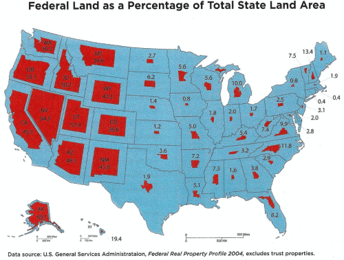 Share of Federal Ownership of Land per State (2008)
If he aggregation of such lands, often desert, conceals the rapid rates of buildings in much of the west, the datasets that inform the heavily researched The Disappearing West offer a set of countertops that reveal the reduced landscape of the American west to private development. If the above map taunts viewers by describing the over-protection of western lands, it both distorts and omits the huge impact that private land ownership has made on the lived landscape of most western states. In doing so, moreover, it creates a deeply ahistorical contrast between the amount of lands protected in the western third of the United States from their actual integrity as open space.
The mandate to map the actual dismemberment of once-open spaces on the margins of federally owned lands is the mandate of The Disappearing West–and the ability to drill down into finer grained landscape changes across the western states is one of the huge benefits of the new website sponsored by the Center for American Progress. The far greater datasets that the web maps distill direct attention to a degradation of open lands in ways that questions of “ownership” or “federal management” almost intentionally obscure. The Polish poet Czeslaw Miłosz, a poet who both interrogated the limits of his own ability to understand his experiences and the scale of the change of landscape that he saw in his life. While foreign, and an unlikely observer of the California landscape, Miłosz was also an admirer of the American west not only in fictions he had read as a child but who had, in his childhood, been deeply affected by the figure of the cowboy, remembered the rough land of Lithuania that he remained so attached, and the region of Szetejnie in which he grew up as a child: “You were my beginning, and again I am with you, here, where I learned the four quarters of the globe,” a late poem apostrophizes the region; “Wherever I wandered through whatever continents, my face was always turned to the River.” And the richness of Miłosz’s work as a poet of the landscape of loss, and of the human tie to the disappearance of once-known lands, makes his work a compelling foil to consider the poetics of the interactive maps of the Disappering West that he probably would have loved to explore.
Miłosz spent his childhood as evidence of the survival of a past life–and landscape–whose departure he was particularly sensitive, and long tried to remap. Milosz was also an especially keen observer of borders and boundaries–“I was born and grew up on the very borderline between Rome and Byzantium“–and brought this sense of himself as a witness both to the departure of the lost landscape of the Lithuanian forests of his childhood and the landscape of much of northern California and the area around Berkeley, which he both ridiculed at first as remarkably rural and backwards, but which, while he remained alienated from it, provided an intriguing landscape–a Magic Mountain–whose Eucalypts and fog he felt sensed, admired, and felt himself at times giddily surrounded if not immersed, but against whose change he also came to measure the survival and loss of the landscape of the greenery of the past.
But the open landscape of northern California had contracted so rapidly since his arrival in 1960 that it increasingly provided a set of prompts of reflection on the lost landscape of his past, despite its geographical remove–a Miłoszian topos of one’s own inability to comprehend one’s own experiences and the recession of the past experiences that grew further away. Indeed, if the landscape in which Miłosz lived was one of exile, it was rich with recurrent memories of the remove from the land of his childhood, Lithuania, and its rich forests. He studied its landscape not only in the map of Lithuania that he had in his rooms in Paris in the 1950s, and which he carried with him as he moved, but in the pleasant discovery that he described of the older German maps of the regions where he and his family lived, and his grandmother did laundry, which he so often observed, absorbing memories from them, in UC Berkeley’s Map Room in the Bancroft Library when he lived in northern California.
The remove of looking at these maps of Poland and Lithuania in a ways echoed the Romantic Polish poet Adam Mickiewicz’s celebration of Lithuania by his place of exile from it–the Lithuanian landscape–“Lithuania! My homeland! whose worth is only truly appreciated by he who has lost you,” Mickiewicz began his nationalistic Pan Tadeusz. Miłosz described the lost commonwealth of Lithuania as having disappeared from maps, but survived as a multi-ethnic unit over the longue durée, and as such analogous to Transylvannia or Languedoc. He had returned to the loss Lithuanian landscape in old maps that rematerialized a tactile sense of the past, in ways that partly mirror the sort of access to the disappearance of western open landscapes. If this relation to the landscape was to be rematerialized in his poetics, where he invited readers to examine the removed landscape or his youth, he also explored maps of the lost landscape in the map room in UC Berkeley’s Doe library as an aide de memoir, and an opportunity to look with some longing his native Lithuania, and trace buildings and estates on which he grew up in the German wartime maps, and discover in them a new poetic relation to their space.
Miłosz defined himself increasingly as a poet of the disappearing past, and of the human relation to landscapes haunted by the past and the materialization of its vanished past. “I did not choose California,” wrote the poet declared in the stunningly palimpsestic The Separate Notebooks (1981), with some defiance in a reflection on his itinerary of cultural migration; “It was given to me. What can the wet north say to this scorched emptiness?” But if “the landscapes–and perhaps sprites- of Lithuania . . . never abandoned” him, and he wrote in the 1950s with a map of Lithuania on his study’s wall, the vision of the San Francisco Bay provided a basis for a new testimony by the exiled poet that, if it must have in some ways seemed a landscape removed from time, Miłosz became increasingly attentive to how changes in the “scorched emptiness” of northern California was subject to the effects of a passage of time, at odds with the sense of eternity that he often evoked of its woods: the same sense of being a poet of witness that long filled the poetry of Miłosz about the Warsaw ghetto, most famously, and the Lithuanian landscapes of his childhood, gained new meaning as the potential of landscape change struck him so powerfully when he returned to the Issa Valley in 1989, after he had lived in California for some thirty years. Lithuania returned, magisterially, in his later poems, reciting the name of each and every tree on the old estates he had inhabited–apple trees and pear trees bowed under the weights of fruits; the primeval oak forest; adders; black grouse; black loam–and the violence that had been done to that landscape since his youth. For Miłosz remained a poet of resistance to the disappearing past. (“I asked the director of the collective farm to show me that village;/ he took me to fields empty to the edge of the forest, stopping/ the car before a huge boulder./ ‘Here was the village Peiksva,’ he said, not without triumph/ in his voice, as is usual with those on the winning side./ I noticed that one side of the boulder was hacked away,/ somebody had tried to smash the stone with a hammer/ so that not even that trace would remain.”)
The survival of traces became something of a theme animating many of his poems. Miłosz’s poetry had long remained particularly sensitive to the effects of the passage of time in the landscape that might be paired with the maps of dramatic landcover change in the decade after he left Berkeley, and roughly up to the year of his death, which themselves testify to the rather sudden historical transformation of its formerly open lands. Famously, Miłosz had lived through and wrote on the departure from these once open lands and the forests of Lithuania where he grew up, and which he associated with youth, much as for the poet Adam Mickiewicz, Lithuania was remembered as a private homeland, situated at a remove from his present, but within an idyllic chronotope of his childhood and youth,–“Bear my grief-struck soul to those wooded hills, to those green meadows . . .“–bearing something of a remove from the country he loved, with the effect of poetically transforming its landscape to a removed locus amoenus. Miłosz seemed to value the “untamed” Northern California landscape by analogy to the Lithuanian landscape the Romantic poet Mickiewicz had viewed and valued as a basis for national uniqueness as a Lithuanian poet–and which he had preserved in his mind, as an oeneric landscape caught in the tension between the historical eras; even as a land of exile, Miłosz may have sensed a similar bridge internal to the changed landscape of the Bay Area. Milosz may have at times come to view the Bay Area’s transforming landscape via something like an analogy to the lost Lithuanian past, whose absence the dry hills of California must have rather cruelly reminded himself, but readily recast himself as a witness to the changing of the local landscape of the East Bay, when turning from the Bay which he contemplated from his house on Grizzly Peak Blvd, to the witness of its loss of open wild spaces as a metaphor to recall the landscape of his youth kept alive in his poetry. Few were as sensitive to how the nature of observation is time-bound and as sharply and keenly felt as the past, or as preoccupied with the loss of the reference points that his poems and fiction seem to provide a space to preserve.
4. The question of how to confront this new landscape that made such an impression on the recently defected Pole who felt so isolated in Paris is captured in the thirteenth page of the Notebooks, suggesting his careful observation of the dryness of the new unknown terrain: “What can the wet north say to this scorched emptiness?/ Grayish clay, dried-up creek beds,/ Hills the color of straw, and the rocks assembled/Like Jurassic reptiles: for me this/ The spirit of the place.” If Ammon and Cliven Bundy were motivated by their ill-considered attempts to act on a sense of place, with “the fog from the ocean creeping over it all,/ incubating the green in the arroyos,” Miłosz meditated quite fiercely on the changing landscape in which he lived, drawn to poetry of Robinson Jeffers, and its histories. The poet Milosz treated the act of writing as a necessary attempt to preserve the relation to the moment, and an image of space, even if he was sensitive to the value of the role of the witness to mark the passage of time: Miłosz wrote in a deeply ethical way to capture as if to redeem a relation to space, using the precision of writing as a personal ethics to capture a relation to images of place against the inevitable passage of time, and after having long been a witness to the passage of history, by the time he had arrived in California, wrote with urgency to preserve a personal passage of time, and indeed mark the transformation of a relation to space with a sense of historical urgency that unexpectedly resonates with the attempt to track the rapidity of the changes in landcover and shrinking of open wilderness across the American west. For an observer of the close of the nineteenth century and historical passage of time in the Warsaw ghetto, and the “dark black and red world” of the destruction of its cities by Nazi soldiers, and the lost landscapes of Lithuanian huge pine forests and old estates he invites his readers to enter. For the problem of the apprehension of a receding past was only able to be recreated in his poetry.
The poetic balancing act of capturing a moment against the passage of time echoes the temporal tracking in the of the degree of loss of open spaces in the dramatic Disappearing West tracks in stark red colors the intensity and nature of the penetration of human development across the western lands of the Bay Area at a vividly granular level that had already occurred by 2001, due to the very consumerism and expansion of residential development that Milosz, a lover of open spaces, disdained, in the area that he worked hard to make home, only to witness the change of its open spaces on even greater scale that the slider bar captures in indelible red.
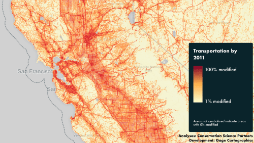
The maps help to preserve a sense of the particular urgency of preserving a clear-headed relation to the collective transformation of place, and indeed a habituation to how an ideology of development has resulted in the changed configuration of open lands. For the transformation of the region over a decade with the land modification that resulted from increasing transportation corridors quickly and intensively redefined the same space, and the possibility of an observer’s relation to open space, and indeed of noting the effects of a historical passage of time in only a decade of intensely rapid change.
One cannot but think of his mapping of the changing landscape as informed by a deep sense of the passage of time, Defining his personal relation to the landscape as historical was almost second hand for Miłosz, deeply engaged with the history of its transformations over time as he was with the compulsion to preserve, note, record, and map the changing relation to this new landscape, as well as to the past of his Lithuanian childhood, and perhaps see both through a similar lends of departure, melding estate conversion to residences in the Grand Duchy of Warsaw or Lithuanian forests with the expansive conversion to private real estate of the wilderness that surrounded the Grizzly Peak street on which he lived. When he returned to Szetejnie, Miłosz even described the open spaces, now lost, of an arbor in the “greenery gone wild” where “you first forced me to draw my first awkward letters,” even as he retreated to wild “hideouts, for I was certain I would never learn to write”: the space provided the impulsion to write, and writing the only means to preserve it.
The attention to physical detail with which Milosz, who arrived in northern California only after observing the transformation of late nineteenth century Lithuanian landscape and the destruction of buildings in Warsaw by soldiers, observed with disquiet the transience of shifting relation to landscape even in the new California wilderness and San Francisco Bay which he newly made his home seem something of a counterpart to the balance of specific details and historical scale of changes in the landcover of the rapidly developing west. Milosz felt with apprehension the changed northern California landscape against the remembered landscape of his youth, sensing a perpetual sense of loss of tactile presence. “The spirit of this place must be contained in my work,” he wrote in the late collection Facing the River (1995), in a melancholy tone of reconciliation, “just as it is contained by you who were led by it since childhood.”
The rapid pace of development suggest a quite objective sense of the transience of the present in the loss of a recently tactilely present, impossible not to read as charting a detailed record of the loss of a tactile landscape and its former presence. The Disappearing West suggests a similar transience of the past, even if it is removed from a perception, but might have provoked the poet as a charting of the removal of an open past.
Miłosz remained deeply affected by the rural upbringing that he described in much of his literature and long meditated upon in his extremely productive writing, from a meditation on the metaphysical devastation of the modern landscape in the Land of Ulro to California. Although the Polish émigré poet may seem an odd witness of local landscape change, Miłosz was closely tied to the the forested rural landscape where he was raised, a landscape “on the scale of the human” that was still “thickly wooded by oaks,” that his observations of the changes in Walnut Creek in a 1987 entry in The Year of the Hunter, a diary of the year in California from the summer of 1987 to1988, the temporal and eternal become the topic of consideration between the newly modernized landscape of the once open spaces of Walnut Creek. In an especially acute as a record of the modern landscape, Miłosz described the shock of revisiting the changed landscape beyond the Berkeley Hills, in other direction from the Bay, which he remembered as he first visited it in 1960, and as being forcibly struck by its recent sudden contraction of wilderness as emblematic of a greater loss of access to a natural world, and the value of its immediacy.
An outsider like Miłosz may indeed seem quite an unlikely observer of the western landscape, but long understood his rootedness in relation to the land, and the old sense of an inhabited world that could be recuperated through maps, as the maps of the German military that he consulted in Doe Library in the University of California, to observe the rivers, farmhouses, and villages where he grew up, from the odd remove of the empaneled room under flourescent lighting, in a vault Milosz compared tot he vault of trees that once extended above his head. The poet’s sense of witness of its change grasped their consequence in ways impossible to map objectively. Miłosz had matured in rural areas of Lithuania, which long provided a basis for his orientation to the world; and commemorated the loss of open lands with the increased parcelization of its dense woodlands during his early childhood. If the forested landscape of the Issa Valley in his early novel of the same name resurrected a lost relation to a past landscape and its sounds by the thick descriptions worthy of a naturalist, in which he had evoked a time of immediate contact with the “safety of the tall forest” and the broad use of woodlands as a commons where timber was harvested carefully for common needs. In his early romantic novel, The Issa Valley, Miłosz had sought to recuperate the proximity of perceptions of forested land: written long before he came to America or California, the composition of the evocative narrative set in a seemingly timeless landscape and its disappearance.
Miłosz wrote his novel long after he had left Poland and lived in Paris. He wrote it in hopes to preserve or recover what he felt was the lostt human scale of the relation to the land of his youth: much as he consulted maps of Poland regularly when he taught at the University of California, in evoking the Lithuanian landscape of his youth, the Polish poet wrote most sympathetically about the Manor on the Polish-Lithuanian border which he had regularly visited from the eyes of the child protagonist Thomas, a thinly disguised version of his youth. Thomas is closely tied to the forest and its inhabitants, and is so distraught by any disruption in a wooded landscape for which he felt such “reverential awe” he “would have made plowing a criminal offense,” that he drew a map to preserve the intact ground, in response to the deep changes in a landscape that is about to be parceled by the apportionment of late nineteenth-century Land Reform. The experience of Land Reform may have provided Miłosz with a unique sense of restoring the landscape of the Estate he visited in his youth, now preserved in Krasnogruda, to preserve its forests in an act of heroic cartography. Young Thomas maps this lost landscape in colored paper strips, as a “virgin forest” as a landscape with some meadows, “laced with blue strips of canals and lakes as [its] only arteries,” mapping the entirety of its expanse in a map of green strips of paper, crisscrossed by rivers. The soon to be fragmented forest is for Thomas the site of “all the Kingdom’s inhabitants–. . . the bison, the elk, and the bear [who] lived exclusively off the land,” and as the novel lovingly recorded insects, birds, and animals, Thomas seeks to catalogue the birds that lived in its birch, pine, and conifers in an attempt to comprehend their immensity to try to capture being embedded in its sensory detail and the lush woody environment, rich with birds and burgeoning with insects, that Miłosz so successfully evoked in The Issa Valley.
In his prose masterpiece, The Issa Valley, Miłosz created a deeply ethical relation to the landscape he later discovered the western landscape, exploring the California landscape at first hand and in the work of the poet Robinson Jeffers he so admired. While in Berkeley, he would make pilgrimage to the Rare Books Room to return to maps of Poland and Lithuania in a cartographical fantasy, as if to revisit and inhabit these wooded landscapes lost with time, and if he long viewed the northern Californian landscape as foreign during the four decades he lived there, he observed its history analogously to his memorable hero in The Issa Valley to testify to a human relation to space, during a time of Land Reform in the late nineteenth century that had altered the personal relation to its forested landscaped. Much as Thomas constructs a “paper kingdom . . . that could be assembled and reassembled at will” during the winter months when he lived indoors, and outside of its living landscape, Miłosz’ prose mirrors Thomas’ cartographical fantasy of multi-colored map out of strip of paper by “sheets embellished with watercolor designs, rectangles of all sizes, and boundary lines making up the property map of Gine,” dexterously using or improvising an alternative cartography to recreate his personal relation to the lands he senses are increasingly out of reach–not just seasonally, but due to the impending parcelization and fragmentation of an aristocratic estate. Thomas used cartography when weather confined him indoors to recreate his sense of communion to its lived experience and totality, at the moment when he most felt the land’s absence.
If Thomas’ map clearly creates a child’s perspective on the Land Reforms in the imaginary relation to the forested landscape, and a counter-cartography to the parcelization of the forest, the map is also a figure for how Miłosz’s novel recreated his childhood relation to Lithuania’s forested landscape and the proximity in which its residents lived to its woods. Thomas was inspired to map the forests he loved. After noticing “the rolls of paper with Grandfather and Aunt Helen . . . periodically unrolled on the table” of their manor, which he was unable to read, he created on similar rolls of paper a “kingdom” of its own that provided a refuge in a time of change in response to the Land Reforms, Thomas employed vividly expressive colors of the paper map to preserve a pristine landscape out of “sheet embellished with watercolor designs, rectangles of all sizes, and boundary lines,” to give the forest new integrity as Land Reform facilitated its eventual parcelization; in Thomas’ map, “no roads cut through the forest–[for] how could a virgin forest be traversed by a road?–leaving the riverways, laced with blue strips of canals, and lakes as the only arteries.” The woodlands existed once more in the paper map Thomas crafted as a “kingdom, ringed by quagmires inhabited by the red-hooded snake, was absolutely impenetrable”–as if in a counter-map in contrast to the parcelization of forested lands. The young Thomas was “big enough and bright enough to grasp what was happening” in Land Reform in Lithuania, “but his heart wasn’t in it,” and he turned to maps and Linnean taxonomy in hopes better to preserve what he sense would face impending loss, as if in hopes to capture “impressions of forest spring, whose beauty derived not from any one thing in particular but from a myriad of voices comprising a chorus of promise” from its treetops.
In response to how during “various family conferences held around the [same] table, people huddled over maps and the word ‘reform’ was a constant refrain,” Thomas’ maps seek to order the landscape–as similarly, in a scrapbook a register of the taxonomy of birds who dwelled in coniferous forests, pine, or birch, “concentrating on things that excited him,” he sought to capture adequately the “the endless multiplicity of colors, shadings, mating calls, trills, wing sounds . . . [how] light modulated their feathers in flight,” by “affecting and ordering the plenitude of things that were”–as if to retain a relation to the landscape which “neither ‘reform’ nor any ‘business matters’ could compete. While map are as symbolic forms of distancing, in other words, by Szymborska, in which only “a few trees stand for ancient forests,/ [and] you couldn’t lose your way among them,” the forests are for Thomas living entities and ecosystems. The map Thomas improvised described immersion in an imagined landscape by “sheets embellished with watercolor designs” offer a metaphor to recuperate an imagined relation to the landscape and describe the landscape in which he matured–and indeed as a vehicle for lamenting a lost contact to nature, where Thomas lived as if in sacred communion, in the manner of a young John Muir.
For young Thomas, the construction of his imagined map responded to the confusion and lamentation of the transformation of the lands in which he lived. It also prefigured the poet’s own relation to the formerly Virgin Land of the far western United States when he arrived in California. For Miłosz seems to have struggled with how Land Reforms converted all forested timberland in Lithuania to state property, as state assessors apportioned lands that altered Thomas’–and Miłosz’–relation to a sense of the commons of the forest and its inhabitants. Miłosz would similarly lamented the lost world of children who had lived in the forested lands by Walnut Creek in a manner that led him to recall his own childhood, described in his touching novel The Issa Valley, evoking the tenuous relation to the land that Thomas’ map provided, and the attempt to restore a lost sense of the forested land in which he had immersed himself by making it present to his senses even in wintertime. Who can deny that the The Disappearing West traces a similar counter-cartography of even broader scale, mapping the transformation of environmental change and processing the consequences of recent development to multiple layers for viewers to investigate.
Miłosz similarly mourned this loss of virgin landscape in the West. It’s not much of a surprise if the changed presence of woods and vegetation in the open spaces of California provided Miłosz with an occasion for meditating on the loss of landscapes which he felt so directly tied–if not landscapes “on the scale of the human” of his youth but of a more monumental grandeur. The changed landscape of the region offered a powerful invitation to reflect on the vanished Lithuanian forests of his childhood in his prose masterpiece The Issa Valley, as if a melancholy witness of the changed landscape over time. “I did not choose California,” Miłosz famously declared; “It was given to me.” Miłosz valued poetry as a form of bearing witness, and moving from the individual to broad ethical questions of universal character, and wrote not only of his personal experiences: California’s landscape was not only a center of meditation for both its beauty and the species that populated it–and defined its distinct historically made nature–but a landscape for which he was particularly grateful. For the California landscape accommodated the moral voice in which Miłosz wrote that was not only personal, but had an urgency that transcended his own experiences. As he described his birthplace on the “outer edge of Europe” as the best place to witness European-ness, he witnessed the California landscape not only in gratitude for its existence but with a shock of loss for what was taken away that day in 1987.
Miłosz had come to reorient himself to the California landscape in his life in quite dynamic ways, even as he imaginarily shuttled between Lithuania and California in idiosyncratic ways as landscapes to whose changes he bore witness: he had assimilated the landscape of California from the view from its hills above the San Francisco Bay, even if he decried its “scorched emptiness” of “hills the color of straw,” and the same “straw-colored slopes” he revisited in Walnut Creek. He tersely lamented the loss of chestnut orchards that once filled an uninhabited valley east of the Berkeley Hills where he lived–“straw-colored slopes punctuated by black oaks throughout most of the year” and “chestnuts in the valley,” which he saw as landscape that registered the loss of its past, if not a changed relation to the natural world. What had once been countryside, if “quite desolate landscapes, with their dry grass and wiry oaks” were no longer by 1987, replaced what had once been “a land, empty and vast” with developments whose artificial irrigation allowed them to be occupied “streets and houses covered with green foliage, lawns, tennis courts, swimming pools, parks”–where, Miłosz marveled, a metro now extended “all the way from San Francisco” to a region whose countryside had been removed from urban life of the Bay Area.
What Miłosz witnessed as a microcosm of the disappearance of open space in the countryside that had begun east of the hills where he lived was a microcosm of the fragmentation of open space, surviving now only in “relics” within developments artificially maintained by irrigation projects. Miłosz felt in 1989 that the place environmental pollution occupies in “universal attention” to the neglect of the growing “pollution of the mind by the image of the world imposed by advertisements”–but the poet bemoaned the loss of the expanses of wiry oaks and dry grass relegated to a lost past in a specific lament against urban expansion as a departure of a lost world of sensations. That same region is today far more developed, as roads, lined by houses with expansive paved driveways and gardens extend into the former farm fields now dotted with shopping malls. For Miłosz, the diminishing open landscape of northern California became a site to reflect on another lost landscapes of his youth; the disappearance of the oaks of Walnut Creek presented an invitation for a late in life reflection on the past landscape of the “swarming world” of the Lithuanian forests, in which “crickets hoped in the grass, beetles raced around, red ants (the ones that bite the worst) and black ants of various sizes swarmed, caterpillars of many colors and shapes were found on the leaves.” In California, insects are today reduced chemical methods, he reflected, and farmlands segregated; the nature of his childhood seemed so distant from today’s childhood spaces, which seemed increasingly, and not only in Walnut Creek, experienced in extra-urban housing tracts clearly set apart from land dedicated to farming. “Now the city is everywhere.”
When Miłosz has arrived in Berkeley, he turned to geographical maps of Poland to gain access to traces history left in the lost landscapes of his youth, tracing arable landscapes shaped by human work that he valued for how they existed on the scale of the human. If he often felt removed or alienated from a modern landscape–Miłosz claimed to have “lived through rebellion against California landscape” for some twenty years–he admired the chain of parks in the Berkeley Hills and its open space of trees, from its eucalyptus forests . He long viewed landscape as bearing the tragedy of the imprint of the human, even evoking something close to how the maps in The Disappearing West trace a broad scale of loss in describing the danger with which “the Universal is devouring the Particular, . . . places which not long ago were celebrated as homelands under oaks trees are now no more than States on a map.”
Miłosz, who spent his youth drawing maps of imaginary forests in a Virgin Land without signs of human habitation, and returned to maps to capture the Lithuanian landscape of his youth with a sense of loss, might have found maps in The Disappearing West particularly poignant tools trace a broader scale of loss; the poet, who spent his youth drawing maps of imaginary forests without signs of human habitation, both used maps to orient his American students to landscapes of Polish and Russian literature–even compiling a set of historical maps for National Geographic of Poland in 1982 after winning the Nobel Prize–to expand their world as he loved inhabiting old maps of his native Issa Valley; he recognized the rapid change of the late twentieth century as changing his tie to the California landscape to which he had reoriented himself. It’s hard to tell the story of the transformation of the Western United States where Miłosz lived, but the interactive web maps in The Disappearing West help to encompass the scale of a too often overlooked massive collective transformation of the landscape, and the departure of its open spaces, detailing the levels of acreage lost to human development across the transformed landscape of what were once open lands. “A sensible computer,” wrote Miłosz elsewhere, “would not neglect climate and landscape,” or land cover.

6. The hugely expanding “human footprint” across the western states has been mapped in the past, most recently to represent the concentration of the human impact on the same landscape that is so distinguished by protected public lands, areas of which can still be called the most untrammeled areas in the country. Based on work of the USGS already reported in 2008, the board human impact on the region–from urbanized areas to farms, roads and transport networks, power lines, energy prospecting and man-made wildfires revealed minimal human impact on only 5.5% of the region in the same area, which showed undeveloped lands as increasingly vulnerable.

Indeed, areas designated protected wilderness or maintained as such across the west are both closely proximate to “developed” areas–and the most significant collective human impact mapped on the landscape was due to agriculture that often border wilderness areas, as what was measured was not the loss of open lands, but human impact on lands.

The expanse of a low human imprint is apparently large–magnified by the broad consideration of an only 19-25% human impact on the landscape as cause for rendering in green, without considering the loss of open lands. In the interactive website, the degree of lost landscape is pared in ways that viewers can explore to examine the scale of degrees of modifications and development on open lands that have affected each of the eleven western states, rendering the scale of changes of lost open lands as seared into local landscapes. Deep red inroads mark the extent of land modification and betray an intense regional population growth, and suggest the increased dangers of the fragmentation of open areas across the west–as well as in the vert same area Miłosz had described as becoming part of what we now know as the growing extra-urban areas that have so radically changed the American West as a region to start to ken the broad scope of collective changes that have occurred on what was once virgin land over just a decade.

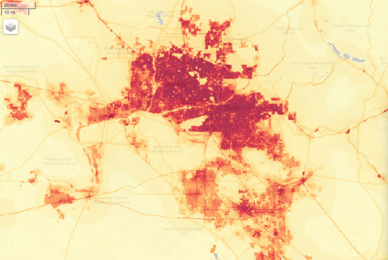
The dramatic expansion of land modification is fed by population growth, and a thirst for subdivision of real estate. While it is hard to map the consequences of the change of landscape that the loss of open spaces has brought, and how their loss qualitatively changes understandings of place, the increasing absence of open spaces revealed in largely quantitative brushstrokes Disappearing West, a richly interactive project that has been funded by the Center for American Progress, based on the analysts of Conservation Science Partners, measuring some 105,000,000 acres transformed or “modified” by human development since 2001, using both satellite images over ten years, and multiple datasets available for ready downloading as well as zooming in to scrutinize in stunning visual rendering of deep chromatic variations.
Without providing anything like a quantitatively based assessment of the landscape’s loss, Miłosz poetically remembered the loss of the archetypical landscape of the west in Walnut Creek as a departure, noting “What happened here is a pattern for the entire planet, not that it has to look the same everywhere, but a clear pattern is developing, if only with regard to population density,” Miłosz wrote in elegiac terms. Miłosz poetically evoked his own relation to the alien land in which he had arrived, shifting from his role as external observer or tourist to witness at the turn of the millennium, and suggest the parallel of the loss of contact with the land that occurred in his life. “It has been given to me to see in one lifetime the end of the countryside,” he wrote with some darkness, describing how that landscape of the west he loved vanished: “So, housing tracts are scattered over a great distance, preserving relics of the countryside, but only maintained artificially: irrigation, trees, spaces set aside for sports.” The California landscape had grown on the poet, who felt increasing gratitude for its open spaces he increasingly discovered there, where he could repeat the projects of canoeing and river-exploration of his youth. As the inhabitation of California came with a cannibalistic conversion to the needs of suburban livability, the erasure of the natural landscape seemed to reflect the loss of the rural area in which he spent part of his childhood–another landscape now irrevocably past, the scale of development of which Disappearing West starts to map. When in Berkeley, Miłosz regularly turned to old maps of Lithuania and its forests as if to search for traces of its past inhabitants and vegetation by an imaginary magnifying glass, and compiled a set of historical maps for National Geographic of Poland in 1982, as he had regularly used maps to orient his American students to Polish and Russian literature. The Disappearing West invites its users to navigate the traces of land modification over time.
While it is hard to map the scale of changes in a landscape across time, even equipped with a slider bar, the county-by-county mapping show the removal of open spaces–spaces for wandering or roaming, without built environment–in particularly compelling graphic terms by parsing the once-virgin west by the degrees of the loss of open spaces, shading the most severe losses in the darkest red, and creating a surface one might hover over and explore in local detail, to try to take stock of the extensive anthropogenic change that the landscape suffered before and during the decade 2001-11. We can trace the expansion of built housing on a macro-level and zoom into areas to look at it up close to try to tell the complicated narrative of the increasingly significant losses of open lands in ways that viewers might scan and drill deeper to better visualize and comprehend.
7. The accelerated loss of open lands across the west to a combination of urban sprawl and development–both of which advance at far greater pace than forestry or agriculture–is the subject of the interactive website we are invited to explore by the nonprofit Conservation Science Partners. In The Disappearing West, data visualizations on several scales show a landscape that invites us to scratch beneath their surface, and invites us to explore the extent of that loss, suggesting its particular concentration in California but mapping the scale of lost landscape across the western states. The maps we can explore and expand raise a level of percentages of open land that disappeared as the primary layer over the landscape, registering towns and monuments in a typeface of light opacity, as if one can process the changes over time, although the shifting landscape can’t ever be so clearly mapped: despite a slider bar suggesting the loss of lands in western counties, and an interesting interactive map of the penetration of paved roads into roadless areas, the scope of the experiential transformation can only be considered in relation to these maps.
However, the deep reds of disappearance challenge us to take reckon with the scale of the transformation of the landscape and the reasons for the disappearance of its open spaces, rendering the scale of the loss of lands over during that decade, and helping parse urban sprawl in visually arresting terms. The website invites us to explore the extent of that loss, suggesting its particular concentration in California but mapping the scale of lost landscape across the western states, in ways particularly of interest to relate to National Parks. The subtraction of open lands is oddly quantified in the interactive website by percentages of loss and loss of open lands–we can, while scrolling over each county, parse the relative intensity of the subtracting 2,343 square miles from western wilderness–over 1,500 square miles for energy development. But the atmosphere of place that this seems to erase even more deeply is hard to represent.
Miłosz had evoked the lost landscape of Walnut Creek as a point of departure or entry to a reverie of the spaces of his own rural childhood and his exploration of the world of insects, forests, and rural areas. The vast transformations which he was describing occurred with such quickness that the lost of open spaces was not charted. But the pace of the change in space and shrinking of diminished spaces across the west–of which Walnut Creek might be an odd microcosm of the western wilderness the poet might have expected to encounter–have now been charted, county-by-county, overlaying cumulative lost natural area on a lightly etched terrain, whose contours and place-names peaks through the polygons of colored in varying degrees of emergency, from yellow to deep red, as if to alert us to the changing nature of the former countryside that they describe, revealing a changing repeopling and repurposing of open lands, and suggesting the regions where a past sense of place most prominently receded, and where the loss of open lands and natural spaces was most intense–without giving us, except in condensed description, why the loss of open spaces occurred or where they did occur at the greatest pace on the broadest of scales.
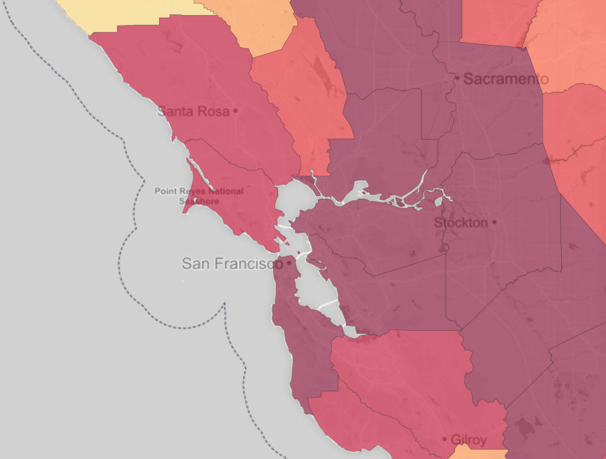
The Disappearing West depicts the severity of losses in a landscape in particularly vivid tones, and not only quantifies the loss of natural lands in California (785 sq miles), Colorado (525 sq miles), Wyoming (496 sq miles) and Washington (456 sq miles)–but it allows us to zoom in where it renders the losses as a scarring of the surface of the map, and maps the greatest losses of space on private land. While described as lost “natural” areas, many are so abstract to only lead us to conjure the scale of losses they describe, but the thousands of acres lost to development in Contra Costa County from 2001 to 2011–10,661, making its rate of loss of land to development some 555.7% higher than the rates of loss of open spaces across the West, and lost “natural” areas 341% higher than the rest of California–reveals a massive collective conversion of open spaces driven by real estate and population rise. In neighboring Solano County, the portion of natural areas lost each year from 2001 to 2011 were 259.3% higher than elsewhere in California, and 434.4% higher than across the West; in San Joaquin County, the loss of 8,086 acres to development in the same period were just over 100% higher than for California and 206.4% higher than the West as a whole. All are colored carmine to note the severe degree of their loss of open space.
The transformation or conversion of open spaces to extra-urban sprawl suggests the vast concentrated loss of open lands–a loss with considerable consequences for urban areas.

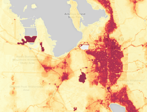
It is hard to process or comprehend the scale of a departing western landscape of natural lands before a two-dimensional map, the expansion of urbanized and extra-urban areas across the west finds its inverse in the disappearance of open areas across western states. The loss of open areas, warned Interior Secretary Sally Jewell, has proceeded in much of the west at a rate of a football field just over every two minutes, disrupting ecosystems and effectively creating one of the largest anthropogenic changes in our open spaces to have been witnessed in a generation: Jewell expressed her fears that, continuing on the current trajectory, within the century “national parks and wildlife refuges will be like postage stamps of nature on a map,” and “isolated islands of conservation” visited by crowds “to catch a glimpse of our nation’s remaining wildlife and undeveloped patches of land.” One can see as much happening, however, in the development around cities that border State and National Parks, such as Salt Lake City, in Utah–the second fastest rate of growth of urban sprawl in the nation from 2002-10–
 Deseret News (2014)
or the concentration of lands lost around former wilderness, as the “urban sprawl in the forest” in North Lake Tahoe, near the Tahoe National Forest and nearby Wilderness Areas,

 Land Parcels near Lake Tahoe/Lake Tahoe News
–or the massive transformation of the region around I-5, running up the Central Valley of California, and bordering the Ventana Wilderness, and loss of land from Fresno to Visalia encroaching the John Muir Wilderness and Sequoia National Park that lie farther East.

The expansion of Phoenix, Arizona, is particularly evident on the map–
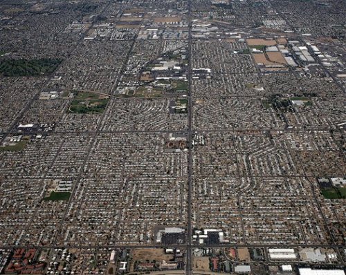 Doc Searls
 Scottsdale/Wikimedia
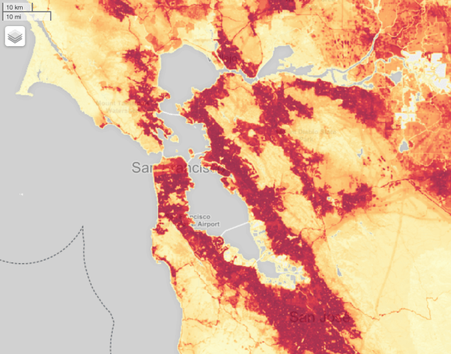
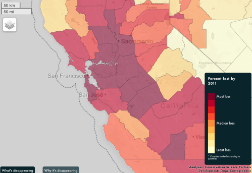
8. At the same time as we are mapping and debating huge global processes of increasing complexity–climate change and warming; sea-level rise; polar melting; glacial retreat; soil subsidence–in hopes to grasp their intensity and complexity, the localization of the loss of open lands in the American West can translate to our immediate sense of landscape. In far more concrete senses than anthropogenic changes in air quality or CO2 emissions can be depicted , much as the retreat of forested lands, the end of open spaces hits home as a massive collective change of relations to the natural world. And if the disappearance of open spaces across the west, viewed county-by-county with apparent ease, such zooming into the local level of mapping has an inherent curiosity difficult to ignore, as if examining a wound inflicted on the region and its ecosystem, by cataloguing the overwhelming extent of overbuilding to accommodate population growth of new real estate. If the percentages of “modified” lands are viewed in closer detail, the deep red intensity of overbuilding between 2001 and 2011 appears etched in quite indelible detail around the shores of the Bay Area, down to San Jose, and as well in areas east.
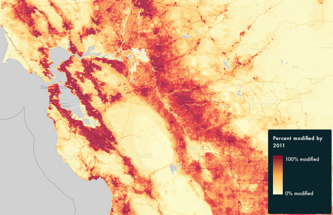
The collective scope and scale of modifications remains difficult to grasp or understand in full, but we can start to appreciate its scale in all its gory detail of the collective intrusion into what were once open spaces: the landscape almost seems to bleed. The calibration of the disappearance of open spaces across the region, cast in deepest red around Silicon Valley, reveals, a decade subsequent to when Miłosz wrote, helps one appreciate the large-scale loss of open space in one region of urban expansion from 2001 to 2011. Disappearing West challenges us to process the scale of changes that have altered the landscape that peaks through an overlay that transitions from light yellow to deep red levels of loss that signal dire levels of emergency, and to imagine the changes in the ecosystem–along the shores, near Half Moon Bay, or in the valley–and for non-human inhabitants at which we can only guess. The range of reasons can only be started to be explored in a website, or the rapidity of disappearance, but the darkening of many counties on the map shows just how drastic that loss of open space had already been and the extent of its expanse.
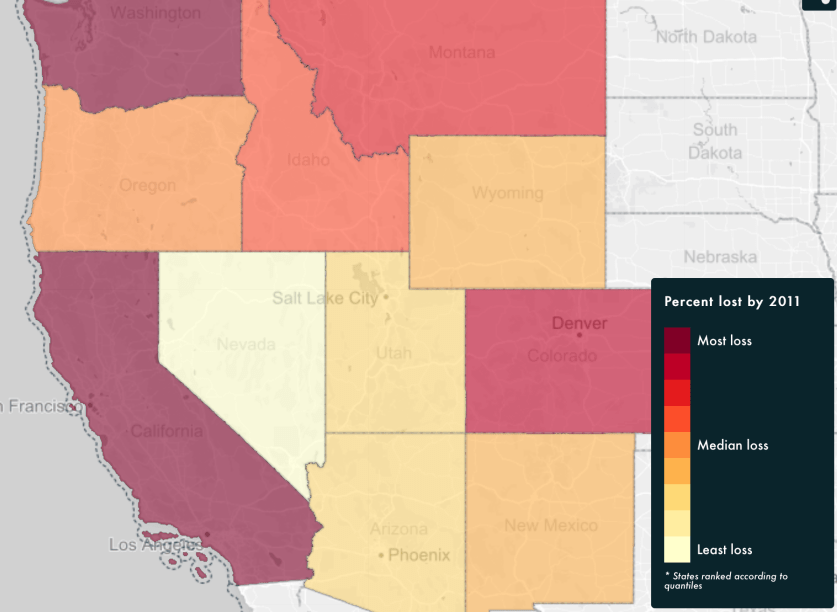
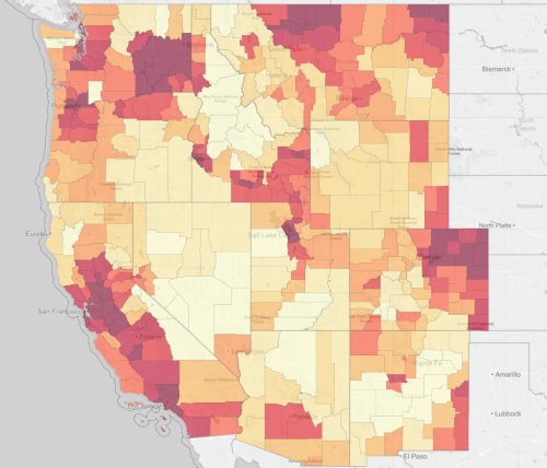
The success of showing the destruction of lands over time by means of a slider bar is only partly successful-in part because of the relatively late starting date of 2001, when so much change had already occurred, and the similar compromises of many regions in the western states. But the decisively deeper reddening of the pacific northwest, the plains areas of Colorado and Utah, and much of Oregon suggests the broad scale at which the west has begun to disappear–and how the rarity and remove of unsettled spaces–or spaces only sparingly settled with human marks–has only continued to grow.
Comparison of the Loss of Western Lands, 2001 and 2011; Disappearing West
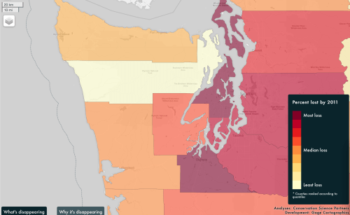
The webmaps might spur a romantic relation to the lost spaces of the past, as Milosz felt, even as he remained unsure whether he was a conservationist against development of the parched land near where he once lived–but these visualizations offers a quite hard-headed assessment of the scale of the collective remaking a landscape, from which only open spaces of the desert seem untouched, at the same time as visible changes occur with the loss of lands around cities–from Portland and Spokane to Denver, Salt Lake City, Denver, Phoenix and Fresno. The loss of land in each area around a city is particularly pronounced, as the incursions of developers into open spaces near the city shade the terrain from crimson to carmine. If one zooms into the map, the loss of green space in each is even more striking.
The underlying causes for the redefining of the local landscape, which can be partly examined in terrain-view as well, range from extra-urban expansion to land explored for energy development and the impact of the growth of private forestry, whose collective footprint can only partly be quantified by the layers of loss. A glance at the interactive map suggests a radical transformation of the West, where the departure of open and wild spaces over ten years often appears limited to National Forests or areas of actual desert.
9. Czeslaw Miłosz’s perspective may provide us with a way to place people in these dramatically changing maps. Some of the areas that Miłosz visited in the Bay Area are among the most diminished and changed–far beyond Walnut Creek and extending all the way to Sacramento, largely because of the growth of Silicon Valley, driven by ever-rising property values. The loss of open spaces in these ten years reveals a huge acceleration of spatial change Milosz had observed over thirty-five years ago. Yet the loss of detail must in part be conjured in the mind–although the interactive map includes not only county-by-county comparisons but more extended discussions of what is being lost in each. It prompts the thought experiment this means for the entire Delta region will be particularly striking over the next ten–and raises questions of its sustainability. The relative ecological opacity of the overlays of counties’ relative loss of open land is not nearly as subtle as the poet’s descriptions of the local landscape, or its fauna, but it provides a starting point to take stock of the widespread effects of such an expansion of the built landscape.
The loss in much of the regions near to urban areas was particularly drastic, if the loss of open spaces across the state suggests a radically shrinking sense of unsettled areas of wildlife, with deep consequences. The contraction of open spaces around Seattle from Bainbridge Island to Spokane suggests a huge rise of settlement of its open areas–
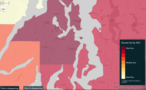
and the boundaries of the overbuilding around Lake Washington makes it seem as if they define the frontiers of future loss of land, but suggests significant effects on the estuary–
much as the loss of land to development that stretches to extend to Bakersfield and Irvine, with concentrations that can’t be captured by the opaque choropleths drawn on county lines, mirrors the dramatic overbuilding of the state with an expanding exurban growth in the areas lying just beyond the cities, where the loss of land seems to have brought increasing incursions into the countryside, creating a loss of open land at a rapid pace.

Such broad changes in the American West suggest a loss of open spaces of long-lasting effects, with a rapid pace of extra-urban growth that has changed many areas abutting national parks. And despite some clamor as to the protection of an increasing amount of western lands in the designation of new National Monuments in the California desert, from the San Bernardino National Forest to the Mojave Trails National Monument along Route 66 to land near Joshua Tree National Park, and despite opposition to “unwarranted” executive actions, the use of the Antiquities Act to link lands already protected creates something of bulwark against the almost inevitable expansion of extra-urban areas.
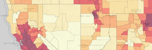
But the deep ways in which local projects of energy development impact the environment of many western states such as Colorado and Wyoming, as highlighted in a recent article from High Country Times, can be more immediately viewed by contrasting what seem Google Earth views of the terrain over the decade–in a split view feature–that reveal the increased number of roads, exploratory settlements, and other developments that have so impacted the very landscape of the American West to increase calls from radical groups such as the Sagebrush rebels demand for a local transfer of federal lands.
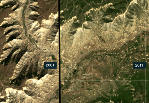 Energy Development around Rifle, Colorado, from split-screen view in Disappearing West
Undergirding this huge change in space is not only ever-accelerating projects of housing construction and development. The loss of landscape seems driven by increased access what was virgin wilderness that a growing network of transportation allowed, as greatly modified transit networks encouraged expansion of extra-urban areas with few gaps–and encouraged an expansion of infrastructure on the edges of cities’ expanding metropolitan areas, from Phoenix to Boulder to Denver, increasing the loss of open areas by a third in Colorado and Wyoming over the same period of ten years–indeed a comparative viewing or urban areas and led formerly low-density areas, like Colorado Springs or Rifle, Colorado to be redefined by rapidly expanding urban sprawl, as timber harvests on private lands in Oregon have changed the forested landscape near the Willamette National Forest.
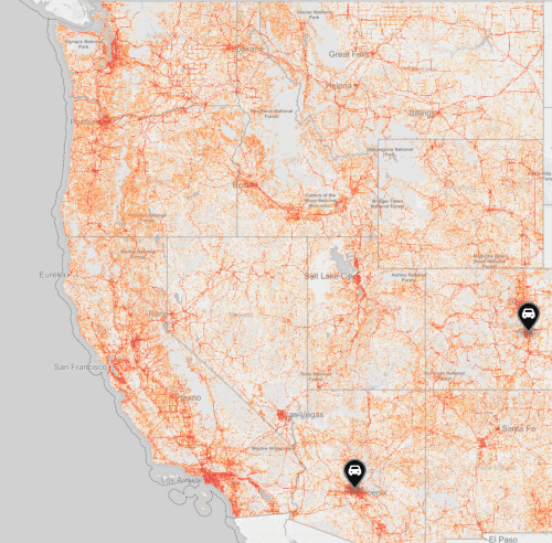
The web maps most distinctively allows strikingly, to view individual regions split-screen, to compare the impact of extra-urban growth near cities, forestry in the north-west on private lands, and even the decline of urban parks. The maps can only partly comprehend the fragmentation created by a growing network of roads where none existed previously, roads that increasingly reach across the landscape to create a sense of the ubiquity of human development.
The broad purview of the Disappearing West website are limited by their time scale–much devastation of the landscapes preceded 2000. But the data is not there with such precision, and the map without the data would lack ability to examine its detailed layers. The county-by-county layering of data is not sufficiently finely-defined grains for appreciating the damaging effects of such expansive building on watersheds, rivers, creeks, watersheds, arroyos, and specific environments or delicate ecologies. The expansion of the network of roads and electric energy is not able to be navigated by a slider bar. But the maps help us to take stock of rapid changes in its built environment, taking a stab at visualizing the scale of expanding extra-urban areas across the west and the landscape rapidly receding from memory, and surviving only as an imaginary of the west, no longer able to be actually occupied.


Another important, telling post, close to home this time and my own recollections long before Milosz’s. Of course what he saw as virgin land wasn’t, ever, if you take into account the depredations of the Gold Rush, the railroad boom, lumbering, dams and water projects, Agribusiness.
Milosz is an odd (and a late) observer of the area–he must have seen found the landscape a remnant of mythical west–and his contrast of 1960s/1986 marked a period of building that was soon surpassed.