
We have long considered man’s impact on the world, but are only starting to be able to chart the vastness of the scope of anthropogenic change. And wen it comes to the contraction of shores and beaches that has been forecast in current climate scenarios, the oldest of human environments, the shoreline and coast, seems in danger of drastic reduction at a scale we have rarely considered. The shifting littoral landscapse of the world have ben long neglected, if they are turned to each Earth Day for coastal cleanups and have been the site of intense preoccupations as a result of sea-level rise, as we have protected much of our national seashore.

But the prospect of an accelerated global erosion of coastal landscapes, and the loss of beaches, have only begun to be processed as triggering cascading consequences from disturbing ecological niches and coastal economies to the human relation to the natural world–a new relation to global ecology that we may well lack the vocabulary and structures to map on adequate scale to process, let alone discuss.
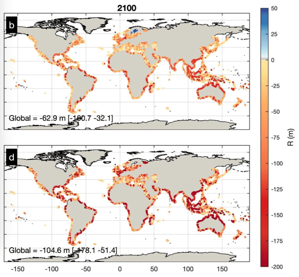
But the mapping of coastal retreat that is projected for the coming century charts the magnitude of the scale of impact of human-created modification of a global environment in NOAA’s Fluid Dynamics Project calls for a broader reckoning of the impact on the global environment that stands to be created by coastal retreat akin to a global pandemic like SARS-CoV-2, and a remapping of the global shorelines that we have a very limited chance to come to terms with in any active context; terms like East and West don’t work in a climate catastrophe that does not differentiate not only nation states but that we lack the narrative categories to come to terms with in terms of economic inequalities, but suggest a crisis of global proportions that contrast with the delicate organization of space on shorelines near our home in their brute redrawing of the increasingly impermanent sandy shore projected for 2100, according to a rather modest climate change scenario.
The discovery of margin of the shoreline in the middle of the twentieth century as a privileged site of intense biodiversity risks obliteration as a particularly fragile ecosystem. Yet the shoreline habitat is now a site of unprecedented vulnerability. (The same stretch of sensitive shoreline habitat was quickly closed to comply with shelter-at-place directive, given the range of urban residents who drove to flood its trails, beaches, and shoreline as a way to find balance, many standing transfixed before the waves in a particularly stressful time, seeking purchase on a moment few could really grasp.)
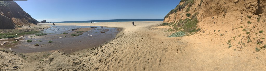
The seashore seemed a natural place of reflection. But it was hard to imagine the sensitivity of these littoral lands. While the national seashore at Point Reyes is a unique preserved coastal environment, where eroding cliffs meet sands along broad strips of beach whose low grade offers habitat to coastal birds, grasses, and shellfish, in a meeting point of fresh and salt water, the beauty of the coast seemed a perfect refuge in a time of disorientation.
This blog has long discussed the specter of anthropogenic change, but in the panic of COVID-19, it seemed clear that we lack the mode to talk about the scale, continuities, and complexity at which such world-changing processes will occur. The future loss of shores would be quite difficult to imagine, even if one stares at the remote sensing maps that predict the effects of sea-level rise.. So many had voyaged to the shores as if by instinct during the COVID-19 coronavirus outbreak in 2020, from Long Island to Marin, to the extent of disturbing many coastal residents, who read searching for break from anxiety by acts of coastal distancing as an unwelcome promotion of the danger of importing viral spread.
In England and elsewhere, many departed from the city, in search of a new environment, by traveling to the coasts–where they were greeted, similarly, by protests by those who saw their arrival as a harbinger of infection. Many public beaches, concerned about close contact, have outright closed, as coastal communities do their best to dissuade visitors seeking to escape infection in Hawaii, Moab, Alabama, North Carolina or the Gulf Coast–in ways that cut us off from the shore as a place of reflection and rumination.
If undue media attention may be directed to bemoaning college students on Florida Spring Break, we must remember that Florida’s Governor, Ron DeSantis, ostensibly encharged with securing the state’s well-being and public welfare, stubbornly insisted on keeping beaches open in the state the shore until Easter, to allow “students to party” on Miami Beach, Fort Lauderdale, Clearwater Beach, and other “hotspots” of pleasure into hot spots of viral infection: DeSantis, never one to stop claiming higher ground, hypocritically or not, only turned his wrath on the partiers after facing a lawsuit from the state Attorney General, and even as communities closed beaches, refused to shutter state beaches to limit the spread of the Coronavirus that were a vital parts of the state’s economy–reluctant to close them until local municipalities intervened.

Shifting the blame to foreign travelers–and insisting on self-quarantining visitors from New York state or New Jersey–he sought to keep them open for business, by casting them as more vital than viral. DeSantis refused to accept the national scope of the problem, defending an economy that depended on tourism, elevating the economy over national health–and keeping them open a week after the closure of Disney World, after trying to keep a “six feet distance rule” to “stop large crowds from congregating,” as if the crowding was an issue, more than human proximity and contact–and refusing to take leadership on the issue by “deferring” to local government and causing confusion.
As fhe Florida Governor reflected on the large number of elders in the state population, and their potential hindering of his own chances for re-election, it seems, did he alter his stance entirely, and beg the President to declare a national emergency, as the spread of the virus led to thousands of layoffs, with all non-essential businesses closed in coastal communities, as De Santis issued a state of emergency March 9, 2020.

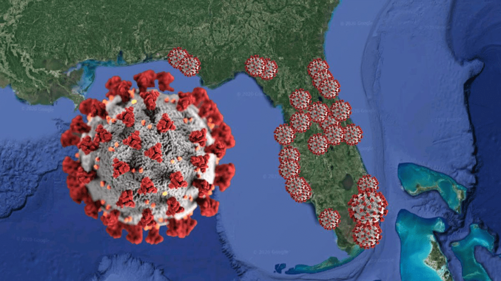
Meanwhile the COVID-19 data timeline by mid-March had spread across Central Florida, with cases of infection clustering on the shores. While the map that sizes the isolated pathogen as its symbol of COVID spread seems freakish, the telling newspaper graphic captures well the problem of coming to terms with the transmission of infections along the beach–superimposing the specter of an overlay of the COVID-19 pathogen as if colonizing or as blossoming along Floridian shores.
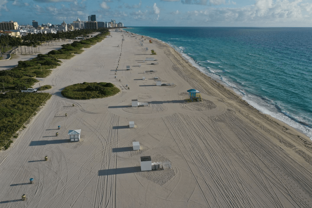
The abandonment of the closed Miami Beach–one of several citie that refused to keep its beaches open, as infection spread, as they knew what was really best for them–seemed to confirm the shore’s status as a natural site of reflection. The scope of projected reconfiguration of future shorelines would effect a deep change in the human relation to the shoreline, as much as the shoreline as a site of shelter and habitat.
For environmental geographer Clarence Glacken, the “traces on the Rhodian shore” were signs of civilization and the human modification of the environment that were fundamental to historical processes of change. The reference of the title of his survey of the modification of land through the industrial revolution took its reference point as antiquity–the image of the philosopher taking geometric figures drawn on the shores of Rhodes where he was shipwrecked as evidence of human habitation. The anecdote was prized by Vitruvius as evidence of the ability of geometry to frame the environment, and respond to it; Glacken took the image of the shores as a leitmotif for a magisterial survey of relations to the natural world that we now observe expanded and refracted in the remote sensing that tracks the broad impact of how industrialization has inscribed human relations to the environment far beyond Glacken’s four on the environmental influences on human history and man’s remaking of the environment. And the problem of the continued access to shores, and future of the shores, makes us go back to some of the early work of Glacken to recover its new relevance, if only because of our failure of models to come to terms with such massive anthropogenic change.
For the extent of this remaking of the environment now goes far beyond intentionality, and the sedimentary nature of Glacken’s history seems quaintly outdated in its scope. The global learning Glacken wore led him to value the apparently odd title as a reference recognizable to the Enlightened of the prominence that Roman architect Vitruvius gave to the happiness of encountering “human” traces of these geometric figures on Rhodes’ shore: geometry was for Vitruvius the basic proof of man’s relation to nature, and a basis for the harmonious models of building structures for human habitation. The increased concentration of carbon dioxide in the environment had barely been assessed by the time the American Petroleum Society organized the American Chemical Society meeting when Edward Teller sought to redeem himself in the public eye when predicting in 1957 the “appreciable melting” of polar ice caps on the centenary of the American oil industry. Teller, noting the “strange property” by which increasing carbon dioxide emissions absorb the infrared radiation emitted from earth, so that a 10% rise of CO2 would be “sufficient to melt the icecap and submerge New York,” and submerged coastal cities where the human race lives, called attention to the threat CO2 levels at the “Energy and Man” symposium, calling them “more serious than most people tend to believe,” suggesting that the melting of icecaps perhaps thousands of feet thick might well submerge the Empire State Building itself.
Teller added a local and tangible illustration of the global payload that atmospheric warming could release for added power: the map predicting shoreline erosion that could cascade may better suggest the global scale of the continued CO2 emissions whose local use has had no perceived local effect. Teller’s warning may have led the American Petroleum Institute to commission the Stanford Research Institute report on air pollution which in 1968 expected a rise in atmospheric concentration of CO2, based on 1968 levels of fuel consumption, to 400ppm concentration by 2000, just recently surpassed, to wreck worldwide environmental damage, the submerging of the Empire State Building Teller conjured at the centennary was less striking than the absent of ability to contain the very levels of CO2 emission of CO2 in smoke and fumes destined to alter environmental equilibrium.
The erosion of shores modeled in different scenarios of global shoreline retreat by remote sensing models suggest the global scale of the importance of technologies to contain the rising of sea levels hundreds of time beyond those currently observed.
The far more spectral geometries of retraced shorelines remote sensing reveals expanded human impacts on the environment unimaginable for Glacken or his readers; remote sensing reveals the scale of impact of human modification of the global environment by coastal erosion in NOAA’s Fluid Dynamics Project of earth as a way of coming to terms with the reckoning of global impact of human life, from the scale of such coastal retreat to a global pandemic like SARS-CoV-2. If Glacken’s history of the improvements of world-making preceded the growth of atmospheric alteration–but use a broad lettered tradition of the globe to survey draining swamps, fixing dunes (undertaken in 1325!), soil fertility, and climactic influence is beneficial in scope, if he wrote from deep awareness of the precarious relation to the land, it was affirming a sense of positive intention
While Glacken was not dedicating energy to describing the American landscape in the manner of his colleague, cultural geographer J. B. Jackson, saw in the sublime of geography, as a broader account of the “full imprint of human societies on the land,” neither man would have imagined that imprint would extend to the rewriting of the coast. While landscape was for Jackson “that which we have daily contact,” and that reveals a sense of “human participation,” the human impact on coastal erosion could not be cherished as a sign of “human presence” that was inscribed in a landscape. Yet Jackson, far more committed to technology than most other geographers and eager to the new perspectives that technology would offer, alerted his readers, unlike the sombre Glacken, in trustful ways to the very perspective remote earth sensing can offer, promising the impending arrival of a means to “discover a new environment and a new relationship between that environment and man and, I dare say, discover a new definition of man.” While Jackson was never a fan of the wilderness–rather, he was a booster of the perspective of technologies of speed, preferring the Pueblo villages and the highways running through the desert on which he motorcycled his custom BMW cross-country from Berkeley to Harvard, his claims are eerily prescient to chart or conjure an embrace of the anthropocene in more totalistic ways than the austere Glacken’s hopes for a rebuilt landscape.
Did these Berkeley geographers reflect on the global role of coasts as they lived in a site where they witnessed a momentous change in shoreline whose wetlands were curtailed from the early twentieth century?
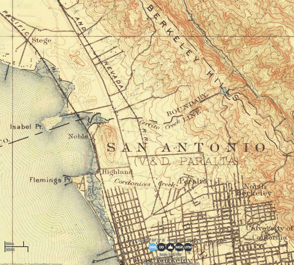

Can we imagine the new spaces on humanity that the erosion of the shores would produce, and the cascading effects of the elimination of habitats? What sort of fate for the human would lie there? Beyond the erosion of shores that we can trace in these maps, the broad scope of cascading changes in shores are, in a Glackenesque manner, the product of unseen structures that will shape human experience of the land, as much as a coherent landscape we can image. Although Glacken provided an essentially optimistic dazzling historical panorama of the human relation to nature, optimism seems undone by the scope of the rising level of global oceans and the new relation to an environment that they would necessitate. The transformation of the shoreline of the East Bay while Glacken taught at Berkeley, or from his arrival as an undergraduate, c. 1920 to the 1990s, was profoundly alienating, as if a place and region had disappeared on its shores–a history of landfill, to be sure, typical of the San Francisco Bay.
In 1967, Glacken’s magnum opus on environmental modification set a basis for world systems studies, from thought on the environments most suited to human life to human shaping of the environment; the historicization of human modification of the landscape and environment beyond intentional form that is forecast in remote sensing models suggest an outcome far more pessimistic than Glacken considered: it is hard to imagine the cascading effects of sea-level covering the shores where the Socratic Aristippus urged shipwrecked companions to “be of good cheer, as I see the traces of men!” Glacken turned to the image preserved as a frontispiece to Enlightenment editions of Euclidean geometry at the same time that the offshore discovery of a famous ancient technology near Rhode’s shores–the mechanisms for hand powered tools of calendrical calculation were found off the coast of the Greek island Antikythera, on a cargo ship with vases in a Rhodian style, that suggested a precise model for planetary calculation based on epicyclic calendar of complex gears for marine steering, and relations of culture and nature in the antique wworld. If the geometric figures had been cited by Vitruvius’ classic architectural treatise in discussing the value of geometric learning, among a broader discussion of relation of culture and environments, and the architecture of landscape modification, it suggested a focus on shores and shoreline development as a telling history of human modification of the environment.
We can see traces of the presence of men today in the projected geometry of coastal retreat. These geometries of global change are removed from any environmental models or human narrative Glacken considered, but their global scale stands to altered the shores much as, for now, the pandemic has interrupted global commerce, travel, and, indeed, for now, migration. But the focus on place that was shared with Yi-Fu Tuan, who studied at Berkeley with Sauer, and on the “built landscape” that intrigued J.B. Jackson respond to the early shift of the architecture of coastal settlement in the Bay Area in the postwar period, in plans to be transformed to a a global hub of commerce. A huge portion of baylands had been reclaimed, redefined, by infill, coastal modification, loss of bays and filing in of wetlands to redefine the Bay Area around highways, before pioneering coastal zone management brought a moratorium on landfill regulation in the early 1960s, hugely significant as a model for local oversight of coastal development. For if the shoreline had been being altered since the mid-1800s–from the effects of hydraulic mining for gold that sent massive sediment to bay waters, to be sure, but remapping the experience of its shorelines, the planning of a shifting relation to the beach and the bay emerged in the postwar period in existential ways.

Was there a deeper meaning of reflection of a historical longue durée in Glacken’s idiosyncratic but deeply meaningful concentration on the scope of landscape modification that had occurred from when he had first arrived in Berkeley to begin his undergraduate education in the 1920s, deeply attracted by the historical study of political institutions and landscape, to when he returned to campus to teach in the 1960s?

Aristippus indicated with a finger the figures denoting Euclidean theorems that link humanity and geometry: the pleasure-loving philosopher made but a small cameo in a treatise on architectural sciences, but the “geometrical “schemata” evidence human habitation made them deep signs of habitation, and indeed of man’s effect on the natural world.
The geometries on the shores of Rhodes today prefigures how remote sensing renders global shorelines. Unmoored from any philosophical orientation, they are emblematic of the reconfiguration of nature and culture far beyond the eighteenth century, as shoreline change is beyond humans’ ability to change and beyond human ability to manage: Glacken used the eighteenth century woodcut as cover of a monumental treatise to affirm the centrality of geometry in nature, it is a bitter bookend to the new geometries of coastal retreat stand that redraw the blackboard where Aristippus divined the man-made nature of apothegms, triangles, and areas of squares.

The shoreline scene staged in the Euclid edition established the common currency of geometry in the civilized world of geometric designs in a new version of an Aristotelian recognition scene of anagnoresis. Without any other possessions able to survive the unjust storms of bad fortune after shipwreck, with only geometric logic carried in the survivor of fortune’s tempests in their mind, geometric precepts were the intangibles that made them human, and that, Vitruvius implied, allowed trained architects to weather unexpected storms. But the geometries of coastal retreat seem to overpower the human subjects: they abandon Euclidean form, and can hardly be imagined, save as a future dystopia.
But like the quantum physics of the twentieth century depart from the equations of nineteenth century physics, the geometries of shoreline change generated by remote sensing reveal dangers of shorelines’ disappearance as sites of sociability and habitation we will find hard to process. The forecast geometries of shoreline remote sensing traces and projects sketch a future world that would critically submerge habitat and all traces of habitation on shores, and indeed the very possibility of the shores’ habitation. In a major reversal of landscape protection, the very foreignness of these maps of shoreline loss makes us fall back on the narratives of the very first world systems models–to take stock of the scale of their loss. While they continue the shifting world of the bay that Glacken and Jackson experienced, the shoreline landscapes they will reveal are not modified by human agency with any intentionality, but as sea-level rise will end the remaining sloughs and creeks of the south bay’s remaining wetlands, the areas that now appear htat risk of flooding, according to sea-level rise (indicated in yellow) or local lands’ soil subsidence (contributing to areas in red) stand to reshape a historical coastline into a shoreline difficult to imagine. as the compacting of areas that were defined by landfill stand to return to the sea.

The extent of coastal inundation and submerging of lands that a changing climate will contribute to the San Francisco Bay stand to redraw the bayshore entirely, Mark Stacey of UC Berkeley’s Civil and Engineering Sciences fears, leading to a broad rewriting of traffic, transportation systems, and public housing that will need to be part of a Climate Readiness Institute’s work, as we work to consider what the scope of future shoreline change may be, and how humans can respond to them.

We should remember that considerable shoreline change was occurring in the very intensive period of landscape modification that the Civil Engineering Department colleagues of Clarence Glacken and J.B. Jackson were engaged. Considerable shoreline change was occurring outside of the office windows where Glacken and Jackson wrote, as well as on the beaches of The Atlantic coast–if without much integration into world-systems models.

Was there an impact of such extensive modification in the turn to consider changing attitudes toward place, considered by many Berkeley-based geographers who had written on the places of sites as the shore as places, from Carl Sauer to Glacken himself, or the role of places as sites of human comfort, as Yi-Fu Tuan, whose pioneering work of humanistic geography seek to suggest the human nature of place as a reassuring site. The power of such geographers’ work may well be closely connected to their witnessing of a deep change and erosion of place in the changing shoreline landscape. If the shore was critical for the work of Sauer and his students, and indeed to his cultural history of human development–it’s no surprise that Sauer’s daughter was an early member of the Save The Bay organization, which effected the first coherent coastal zone management policy, achieving a pioneering moratorium to be placed on landfill expansion, landfill regulation and secured public oversight of future coastal development in the Bay Conservation and Development Commission?

One wonders how the massive reshaping of the coast of the South Bay, once fed by streams, creeks, and slough, had been pronounced, changing the coastal meander that Glacken would have known when studying human interactions with the natural world at U.C. Berkeley in 1923-4. Surely they must have influenced the attention he gave to the shores, and the awfully obscure if haunting image of Aristippus featured on its cover so prominently. If Glacken was a great friend of the library, he must have been familiar with the riparian site of Berkeley, and, even if his office faced the other direction, the balcony of the seventh floor of McCone that overlooked the Bay as itt was in the process of being redefined, and the old drainage of wetlands, where much water from 40% of California ran. The redrawing of these shores–a loss here pictured by a USGS overlay of maps of old and new shorelines in Redwood City, where now the 101 runs between San Mateo and Menlo Park in the South Bay, north of Palo Alto.

