
Locke’s arguments about annexation of lands to a Dominion outside the “State of Nature” was born out of the imposition of a new society on what he saw as a “state of nature.” He did not frame this dominion and the rise of a civil state as a basis to disenfranchise native populations. But his works returned to the figure of the indigenous inhabitants of the Americas, as if to find compelling rationales to do exactly that by redefining worked land as property of those who worked outside of the state of nature in which it had existed–much, Locke argued, as what “makes the Deer, [the property of] that Indian’s who hath killed it”–but by taking the “fruitful soil” of the Americas” that remained resources, “for want of improving it by labour,” untapped resources that were not defined as property in ways that benefitted the Commonwealth Locke extolled. For all the existence of title to royalty, indigenous were not imagined as living outside the State of Nature in the cartouche–even as they were omitted from the map itself.
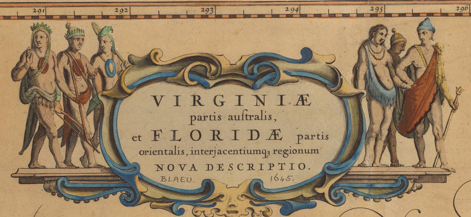
Blaue, 1648
The bounding of property in the New World plantations For European viewers, the riverine lands of the Carolinas would beckon planters and expanded trade in trans-Atlantic markets, and created a “justness” of the appropriation of property of lands waiting to be tilled, planted, and cultivated by the expenditure of labor that indigenous inhabitants hadn’t performed, but whose new inhabitants might enter into civil society and the conventions of property ownership that of “earned property” and the accumulation of property that seems strikingly akin to the plantation system–and occurs as an accumulation from the indigenous inhabitants of the Carolinas who are reduced to a cartouche. The absence in Blaue’s map of any cartographic recognition of land claims or signs of inhabitation are conveniently omitted in ways that Locke echoes, given the “lack” laws that affirm property in the State of Nature, or, it seems, any conceptions of property at all.

Locke’s liberalism left us a problem of early modernity with which to wrestle. How we map prior land claims has been revisited in the twenty-first century as our maps call into question a collective relation to the land, propelled by the increased loss and destruction of native lands.
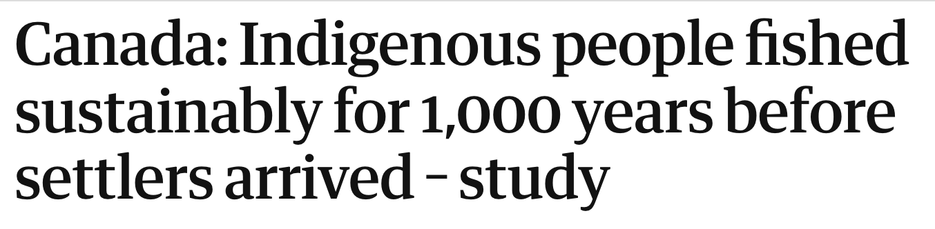
Increasingly, and as if all of a sudden, we are facing headlines on the news that would have been commonly accepted as likely if not obvious–“Indigenous people fished sustainably for 1,000 years before settlers arrived!”–remind us how First Nations community as the Tseleil-Waututh harvested wild salmon by returning female salmons to the river, based on archeological examination of fishbones from 400 BC-1200 AD, confirming earlier sustainable practices of river populations, practices of river management and selective fishing that might allow populations of such Pacific salmon as the sockeye and Chinook that have been threatened by overfishing. The revaluation of a relation to forest management, river rights, and indigenous remedies has suggested a broad shift that has served to extricate us from private property claims.
The revaluation of indigenous rights in the twenty-first century responds to a crisis in the defense of land claims of indigenous peoples, and has also marked the first involvement of indigenous voices in affirming land-claims It is odd to identify the expansion of mapping tools of geolocation that have served prospecting as a basis to affirm land claims that the pictorial map all but omits. But the extension of an invitation of indigenous populations to be stake-holders with the expansion of tools of mineral extraction in recent prospecting projects in Canada has encouraged what might be called a counter-mapping of resources, land claims, and ancestral lands.
If we can accept the technologies of extraction and engines of economics as an a logic that is destined to redefine our ecosystems, remapping the habitation of the land and its resources offers a sense of insight into the collective memory of a lived past, now receded, to be sure, as the prospect of their destruction seem impending as armies of trained professionals, armed with intelligence of petrochemical stores and tools for organizing a geography of natural disaster of untold proportions and scale, as if an impending catastrophe before which it is difficult to counter by a renewed sense of shared ethical responsibility. It is in this context of an attempt to come to terms with the violent displacement of the past that blurred boundaries have become important tools of the active decolonization of how we see space and inhabit it.
For the adoption in many crowd-sourced reparative atlases of indigenous land claims of blurred boundaries, rather than a landscape of land grants and ranchos, present a different landscape able to trigger new land claims or prompt decolonization for staking acknowledgement of the continued presence of lost lands: the overlapping boundary lines in online and static mapping tools provide a knowledge-base for a counter-mapping of digital sovereignty in an era where digital technologies ares used in extraction. Indeed, the possibility digital sovereignty presented in online maps offer may be necessary tools to combat claims of extraction that are altering the landscapes of many indigenous people, and the animals in the rivers and watersheds that they have long stewarded and used, as active sites whose preservation demands to be regarded as something we have a responsibility to preserve: Happy Thanksgiving, indeed.
The fraught ethical status of recuperating the presence of old landholders or inhabitants in lands that seem unoccupied open spaces have historically denied indigenous cartographies with which early cartographers were so often in dialogue–and indeed benefitted. Increased legal agreements that recognize the “personhood” of rivers that have been advocated by indigenous people from the Maori in New Zealand, who have reached accords with the Aotearoa government to recognize the Whanganui River and its rights, or the Innu in Quebec, whose accord with Canada’s government gives the recognition of the personhood of the Magpie River and its right to flow free from industrial effluents and human waste, much as the sex selection in rivers of British Columbia long kept them stocked with salmon that allowed their ecosystem to survive. What sort of cartographic tools are required for staking legal claims by indigenous populations that have long been denied are not clear. But cartographic practices might offer tools for staking land claims not only in inhabited regions, but to reconsider our relations to land, either by conferring legal status to indigenous who settle river banks they have been long denied, or granting legal standing to press suit on their behalf, creating a document able to respond to how GIS offered cartographic tools exposed native territories to a new logic of extraction and plunder.
4. Since Walt Whitman declared his origins “starting from Paumanok“–“sea beauty! stretched and baskin! . . . isle of sweet brooks of drinking-water”–to Malcolm Margolin’s exploration of California’s indigenous landscape, there has been pushback on Locke’s claims by those who want to peel back the layers of property claims in maps. For Whitman, native place-names help orient us to a place we have renamed as we have settled, and given new names that created a new geography of land ownership. We find clear sense of remediation and reparative hopes in the acknowledgement of the complexity of place in the recent work of mapping the hundred indigenous Tongva villages that filled the current Los Angeles Basin, home of the Tongva People, revealed in early maps of Tovaangar, a sequence of villages once housing at least 5,000, connected by commercial trading routes, now obscured or converted into freeways, even if a early maps cannot grant the villages legal standing–or act as a land acknowledgement for a tribe not recognized by the Bureau of Indian Affairs.

While the memory of habitation has long been deeply emotional accessing of the ancestral lands that preserve a common ties to the vanished sacred landscapes that genocide so cruelly erased, the prestige of GPS in accessing minerals and defining place has led to a an increased precision of place that helps apprehend the scale of genocide, and indeed stake out a “war of memory” about older but not always lost homelands. While such a memory of place was long emotional, the state of play revealed in the Los Angeles Basin by the pictorial Kirkman-Harriman pictorial map of Los Angles County. The pictorial map creates an image recording the intense habitation of the region but simultaneously defines it as a reality that was in the process of being actively relegated to past, and marginalized in the current landscape in which indigenous water rights were being denied. Although compiled and made in 1937, it offers a compellingly terrifying map of the state of play in the extermination of the residents of Yangna, ancestral home of the Tongva people, circa 1850, that demands greater attention, detailing the wars and engagements that drove Tongva from the villages that once dotted the Basin and its rivers, from the Santa Monica shore to what is now the San Fernando Valley, across the current Beverly Hills and far past the Santa Ana River, a dense network of indigenous villages linked and tied by trading routes.
These sites have long been erased, and repaved after being systematically displaced and obliterated from c. 1850, the memories of displacement from a web of rivers hardly visible in contemporary Los Angeles reactivates a deep landscape, beneath the geography of missions from the mid-eighteenth century, long since replaced by a new map from Santa Monica Bay to Riverside, CA, and invites question of the ongoing contestations of land, the placement of indigenous presence in California–site of the largest number of indigenous descent of any state–and what it would mean to “re-indigenous” or recognize the scale of loss on California land, or make the past present in the current densely populated landscapes of California. Already, by the 1937, the city of Los Angeles had begun to trade the land where Paiutes had received in exchange for their land with a growing city that sought to obtain water rights of the lands they owned in the Central Valley, reducing the claims Owens Valley Paiutes had on their ancestral homelands, in exchange for resettlement to the planned Bishop, Big Pine and Lone Pine reservations, to allow the city to draw an increased water, where the city promised it would provide needed water that was never to arrive, as Los Angeles Department of Water and Power sent the water that lay on ancestral lands south in an aqueduct to feed the burgeoning needs of an urban population, draining Owens Lake.


The battles detailed in this historical map by crossed swords–LaBrea, August 1770 near the current Hollywood, or by gold mines as late as 1856–create a canvas of the range of battlefields and skirmishes (“Indian fights”) that by about 1860 had erased the villages of which little trace is left in the current freeway systems, and the lost geography that is, as it were, buried beneath pavement and concrete. But the sequence of battles of lost land claims and settlements near missions, valleys and rivers only echoed the ongoing erasure of the indigenous landscape as water was redirected to a new urban infrastructure.
Despite the value of these seemingly careful stories of Angeleno History, the rise of cartographic tools of open source origin has encouraged a reprocessing of this old territory in compelling creative ways. The mapping in Open Street Map or by open source tools of the past landscape of the despoiled urban present is a reminder of our fraught relation to place, and indeed the habitation of past landscapes, in a sort of Open Historical Map–a project currently underway–that might have important consequences for changing our relations to ecosystems and for acknowledging the rights of inhabitants to the land whose voices have been most marginalized–the indigenous–but are perhaps now most important to be heard.

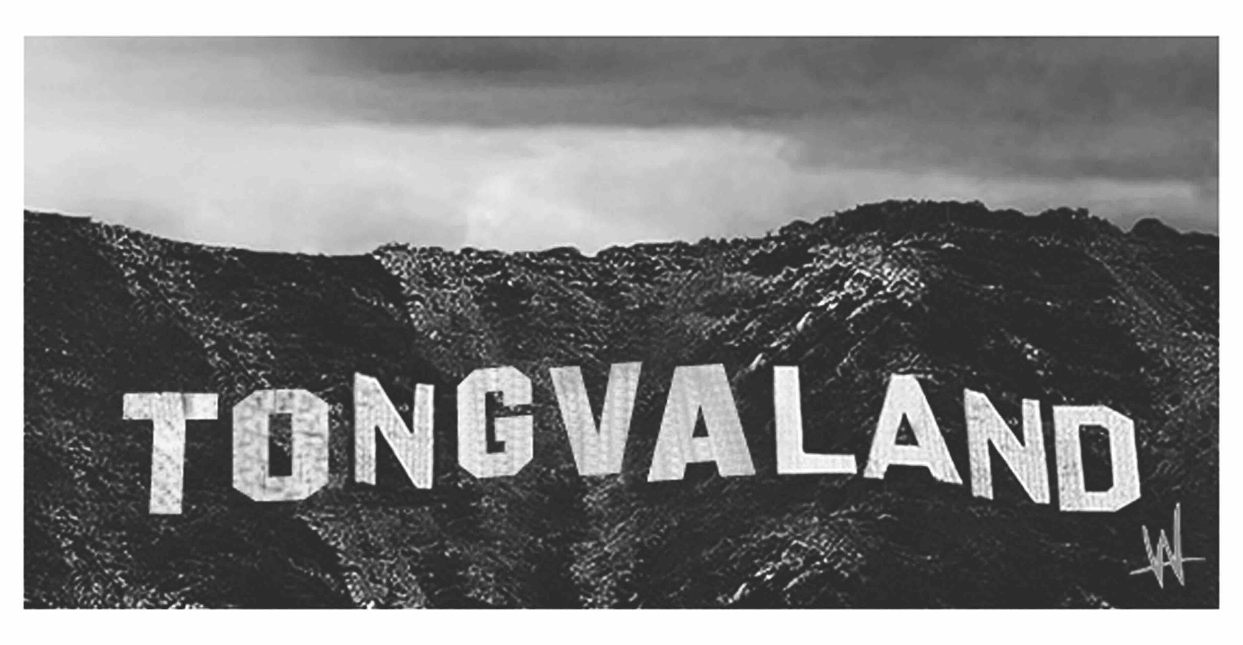
Recent efforts to call attention to a loss of place has been more common in public art projects seeking to expose the losses inherent in renaming, by remediating a relation to place in public consciousness, as much as by staking land claims. A radical artistic collaborative has placed billboards situated to call attention within Los Angeles’ automotive space on the arteries of the 10 and 5 to acknowledge the status of Tongvaland as an identity that demands to be known by Angelenos, the remapping of the state–and indeed of the globe–provides the possibility of articulating the sort of legal standing to mount redress or claim consciousness of impending ecological challenges or impending catastrophes, if by remapping our past, to better wrestle with questions of the ownership and collective responsibility to the land.

We might well see the gaudily reflective letters as inverting the lost presence of indigenous erased in early maps, the gaudily upright capitol letters of reflective metal placed in canyons east of Beverly Hills quite theatrically reflect the absent acknowledgement of land claims in maps of indigenous presence. The most famous California maps of the presence of indigenous, perhaps, the extremely detailed map of indigenous language groups of anthropologist Alfred Kroeber, for his Handbook of California (1925). Kroeber personally publicly acknowledged and supported indigenous land rights by telling the Indian Claims Commission that the entire state, and not only land since identified for bands and tribes, belonged to Native Californians. But if the Berkeley-based anthropologist who had gained fame in the Bay Area for bringing Ishi, “the last known [fluent] Yahi speaker” to the UC campus, where his language was preserved on some 148 wax cylinders made between 1911 and 1914, before he died in 1916, now housed in the National Archives, although Kroeber’s efforts led to his legacy being commemorated on the building housing the Dept. of Anthropology at the University of California, the reckoning of 2021 led the building name to be removed with little fanfare, as a formal review process decided his name evoked the physical removal and removal of land claims of Native Californians who long resided in the state.
")

The un-naming of the building long known by this early student of Franz Boas from a family of German descent who had long studied with an immigrant was sensitive to American racism, and the renaming has been described as more skewed than shrewd. But the renaming of the hall was no doubt an act of resistance to the renaming of the map of California in Kroeber’s life, and the history of expunging indigenous presence from the California map, usurped by claims to legal title and other land claims, increasingly confining indigenous inhabitants to those lands deemed less desirable, and “mapping” their presence in ghostly terms as an artifact of the removed past.
5. Kroeber’s linguistic map is often inaccurate. But his hope to document “Native Tribes, Groups, Dialects and Families of California in 1770,” was revolutionary in 1955, its boundaries drawn to redress a loss of land claims. The map was conceptual, but any map is a territory: and this one, sadly, seemed to relegate the indigenous inhabitants of California to a removed past. Kroeber’s map did real work in showing that indigenous language groups that had been insistently relegated to California’s past still existed, and might even be recorded on a map, as they were registered for posterity in some 3,000 wax cylinders. The map is the territory, however, and Kroeber’s often inaccurate divisions of language groups is seen as implicitly–and tragically–conceding the absence of claims of indigenous inhabitants in California.
But the tabulation–if often incorrect–became iconic as a representation of native families at a time in the very time when an indigenous landscape was irrevocably pushed into the past–after 1928, it could only be seen as a ghost-landscape of language groups that had existed as claims to land ownership had been effectively denied: the academic imprimatur with which Kroeber mapped “language families” in 1922 also made it seem an anthropological curiosity as a project of historical conservation which few really wanted to hear. The “new boundaries” Kroeber appeared to demarcate native peoples left Paiute, Shoshone, Yuma, Mohave and Chemehuevi confined to a reduced rump, far from California’s settled land. But if to a modern eye they elide “language groups” and an all too real record of confinement to arid lands, Kroeber’s mission to define existing languages in use might, for all its faults and inaccuracies, be a resistance of its own to the consignment of indigenous presence in California to a remote past. He was mapping, or trying to map, linguistic presence, and if the concept of one man mapping the entire state before computer databases with any accuracy seems foolhardy, the window to detect living (lost) languages was contracting, and became an obsession for Kroeber, armed with microphones to register the riches of languages of California that already in the mid-1920s had been consigned to the past.

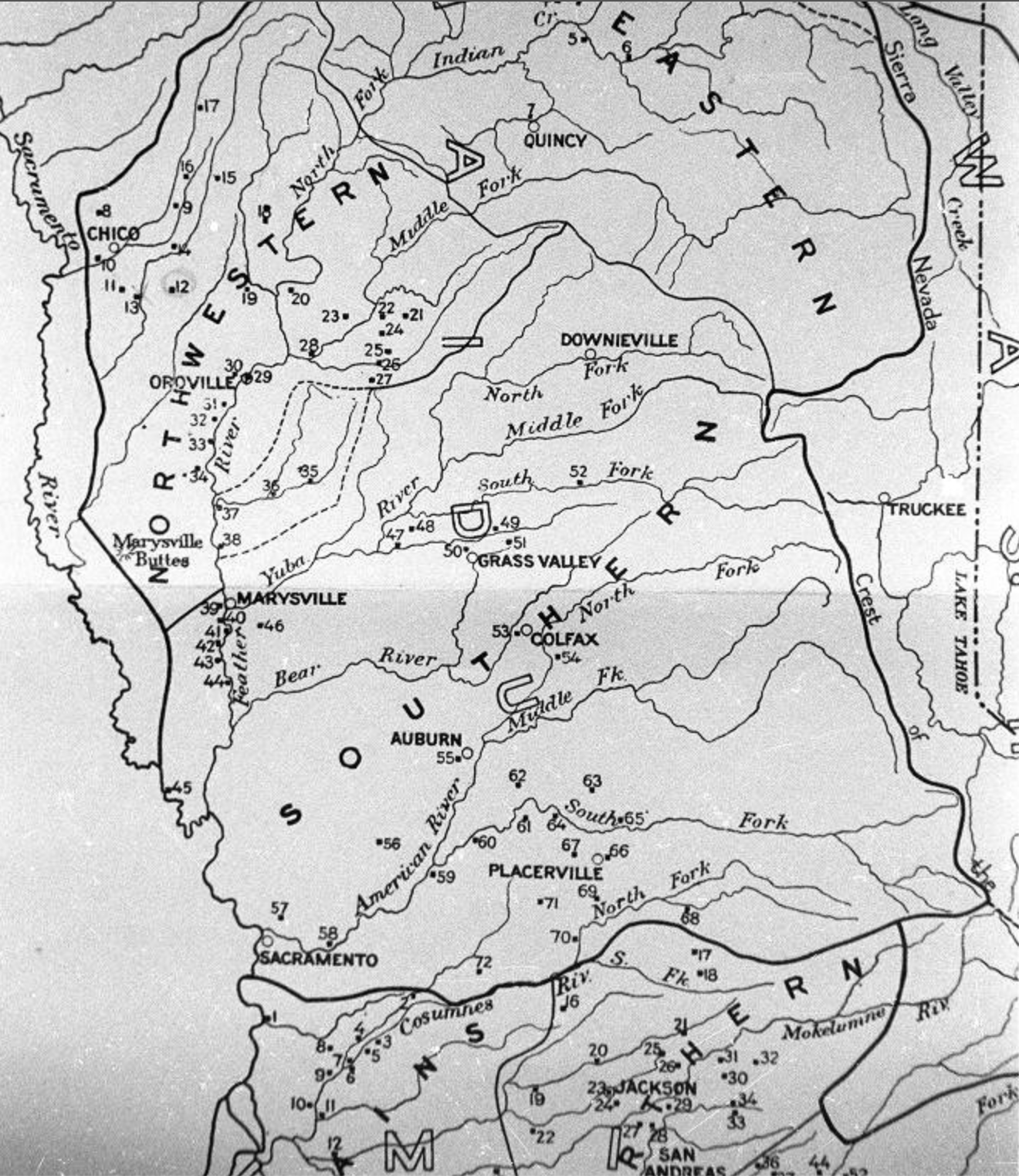
–as the different careful recording of native villages and sites of Miwok and Maidu in the north, where he long lived and worked–a rather brutal geography suggesting a smattering of residual settlements on rivers, as the Feather, removed from the larger cities of Sacramento and San Francisco; if it alleges to describe “territories,” the towns inland from the Sacramento river suggests a continuation of active presence, pushed far inland from northern California’s coastal lands into more mountainous terrain.
To be sure, Kroeber’s map could also be read as a distinctive counter map of sorts, affirming Indigenous presence, even if it did so in historical terms: if it pushed back against the notion of Manifest Destiny, it was a historical record that contrasted to the national map of “Indian reservations” issued by the Bureau of Indian Affairs, back in 1888, that marginalized native presence in California. This “base map” of current reservations where indigenous were confined dates before Kroeber studied with Franz Boas at Columbia University; when he was a ten year old in Hoboken, New Jersey, actual territorial confines had all but vacated indigenous land claims in the entire state of California, far from rivers or arable lands.

Office of Indian Affairs, 1888 (Library of Congress)
Even as Kroeber made his linguistic map, the United States Congress was eager to prevent “Indians of California” from truing to sue for the loss of land in unratified treaties to which individual tribes or groups had been compelled to sign during the Gold Rush, in 1851-2, and to prevent any suit or action by limiting legal standing in 1928, when “California Indians” were a historical people, needing to demonstrate descent from “Indians who were residing in the State of California on June 1, 1852, and [were]now living in said state,” as a collective. The tenuous legal existence of such a group reflected a lack ny existing map of land claims, or evidence of an indigenous landscape. These “California Indians” were all absent from the 1888 map, in which reservations, were distanced from urban areas and effectively displaced to removed rivers–many of which were, sadly, later dammed.

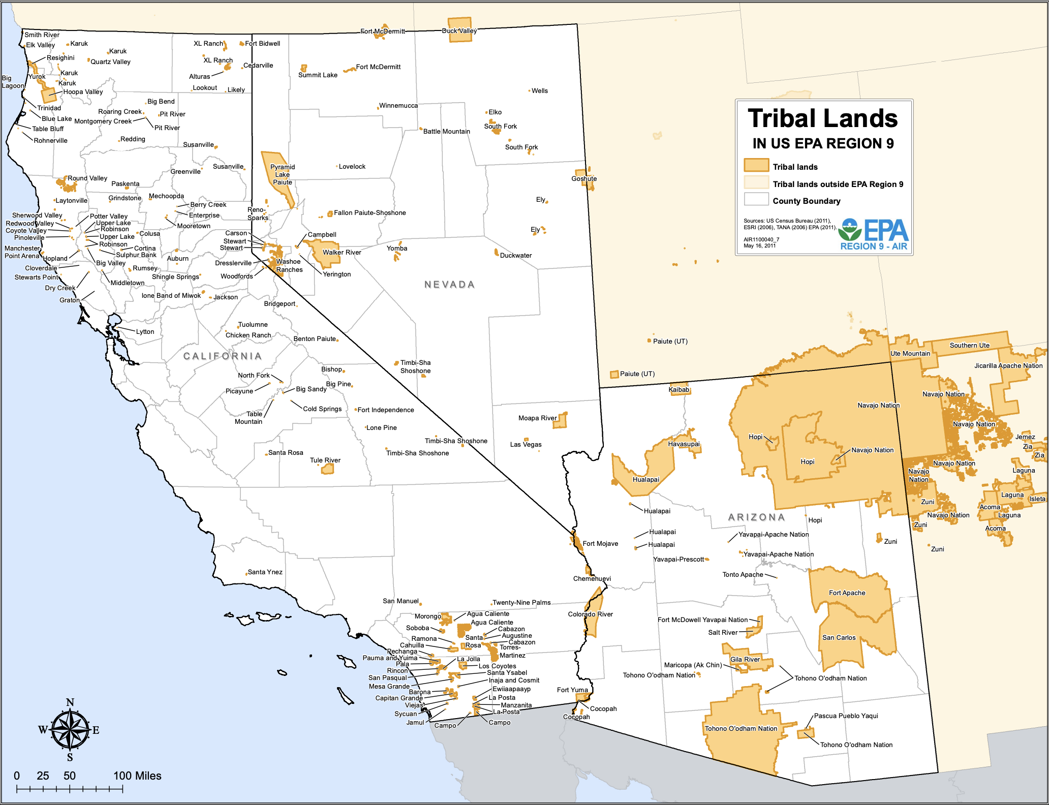
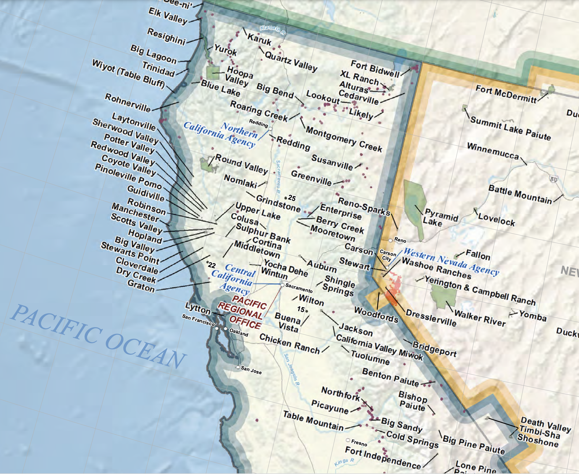
6. It only makes sense, ethically, to carry this narrative through the current map of isolated areas of recognition and land acknowledgements in the current state, against the multiple tribal communities of Bureau of Indian Affairs’ Pacific Region against “Tribal Lands” in the interstate area of “Region Nine.” The distancing of the notion of “tribal” land as a relegation to a state of nature is implicit in the push to recognize indigenous land claims as “native”–not “tribal.”


7. The current practices of remapping indigenous land claims by the early twenty-first century have shifted as satellite mapping and remote sensing of underground oil deposits gave renewed currency and to Lockean claims for the public good–and have done so with some urgency, across North America. Locke had argued property reflected the wealth able to be extracted for global markets from the fields of plantations–as sugar had become a global commodity in the Barbados for planters who lived there, to such an extent by the 1660s that they pressed King Charles II to arrange that they might purchase land in the Carolinas with their newfound wealth–the increased projection of millions of dollars in underground oil (as well as gas) reserves across the Canadian provides a turbo-charged rationalization for the public good trumping indigenous claims. The currently estimated 71 billion barrels of oil in Canadian territories–$166.3 billion in Alberta’s oil sands and 4.7 billion offshore–define a landscape of extraction whose increasing value of extraction was elided with “labor” benefits.

Minerals are present in every territory of Canada, north of the border, but have been increasingly pinpointed with precision as their value has grown as a national good. Valued “heavy metals” or minerals, especially scarce metals as cadmium, uranium, titanium, and platinum used in rechargeable batteries, plating, as well “rare earths” like lithium and graphite, lie in native lands.
Canada seems to promote the map of minerals’ location to promote the increasing importance of indigenous economic cooperation; extractive industries indeed employ 16,500 indigenous in the labor sector, who constitute a disproportionate 12.5% of the upstream economy’s labor force in Canada, and led to over five hundred and twenty five legal agreements or concessions signed by extractive industries and indigenous communities and governments, many still active, since 1974, 356 about exploration and mining. Of the 430 of these agreements of exploration or mining active in 2019, over half lie underground in Upper Canada in Ontario–141– or British Columbia–91–by 2019, and agreements of “exploration” or “development” or other accords multiplied so quickly to double 2006-19. These accords are based on mapping sites of extraction, and the speculation on oil-rich territories or beds of minerals on specific lots. The geolocation of such deposits, now able to be known by the government with relative precision from remote sensing, suggests a knowledge of underground energy reserves lying in native lands that has made them far more vulnerable to prospecting, and more attractive to contractual leasing by extractive industries, leaving native communities vulnerable without access to comparably pinpointed geographical knowledge of oil- and mineral-rich sites.

Red Circle–Impact and Benefits Agreements
Tan–Socio-Economic Agreements
Blue–Exploration Agreements
Temprano’s map, sensitive to the flexibility to boundaries, seems a relation to the lines among states in the United States, which have seemed political and ideological divides in electoral maps, but the problem of mapping the Canadian treaties and cessions limiting “Algonquin” (Omàmìwininì) lands that allowed the placement of the capitol of Canada to be placed at their center.

8. While quite clearly being explicit about its ability to “represent or intend to represent official or legal boundaries of any Indigenous nations,” and directing all interested in determining exact boundaries to consult the nations it maps, is there not a bit of an abdication of responsibility in putting such an admittedly glorious bouquet of pastels online as if they suggest a vision of comity, as much as there is something deeply valuable in having such an easily compiled online resource for mapping North America, and a clear reluctance to not hesitate to indicate the ways boundaries often overlap.
The blurred borders on this image of North America, for example, suggests a potent tool for decolonizing North America, and indeed to establish a knowledge-base in its toponymy for educating and building community about a new sense of land and land claims in an app, empowering individuals by the very accessibility of online tools on screens and mobiles we are all, in an age of globalization, relying upon.

The map is not intended to help adjudicate official boundaries with currency in a court of law, and disclaims up front representing “legal boundaries of any Indigenous nation,” deferring authorship and responsibility of such boundaries to the nation, rather than claiming to synthesize a statement of objective truth. Nor does it claim any status of perfection, but rather an extended work in progress to think better through maps–which makes it so attractive as an alternative text, accepting any “fixes” from local tribes or peoples who have input their approximate boundaries for a public record after they have been omitted from most maps.
Yet the palimpsest of seasonally overlapping claims are especially clear in California, where I live, and provide a measure of responding to the rather tortured history of land theft and competing claims on the official map. The complexly overlapping claims, settlements and jurisdictions of what Bureau of Indian affairs continues to classify among federally recognized Tribes as an independent “Pacific Region” and remains the home of more people of Native American/Alaskan Native Heritage than any other state, ruled by special rules as a jurisdiction, often of federal origin. The land claims are far more blurred and historically complex–
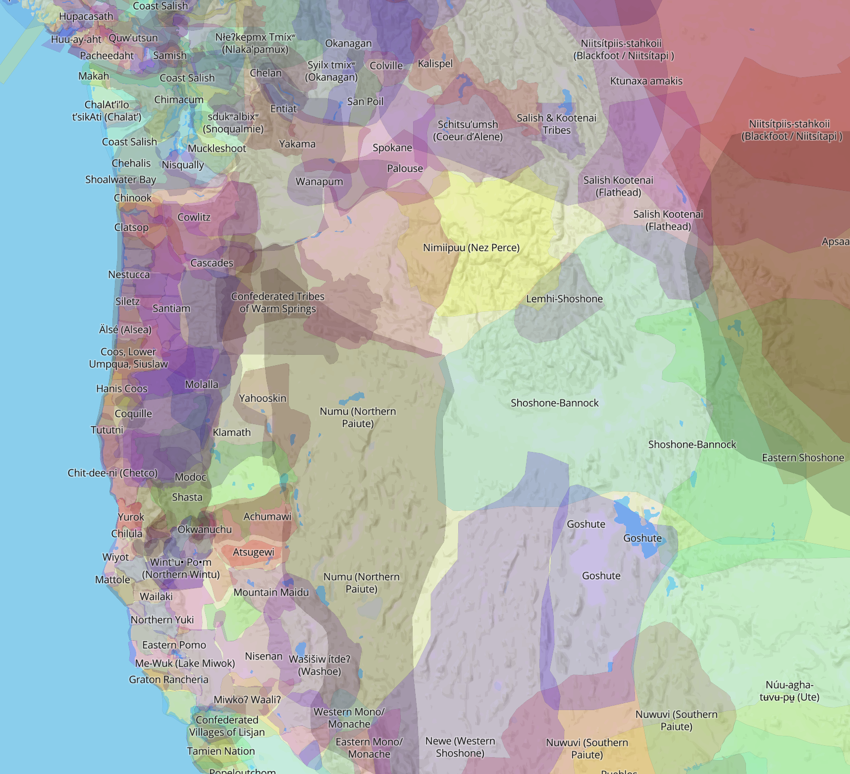
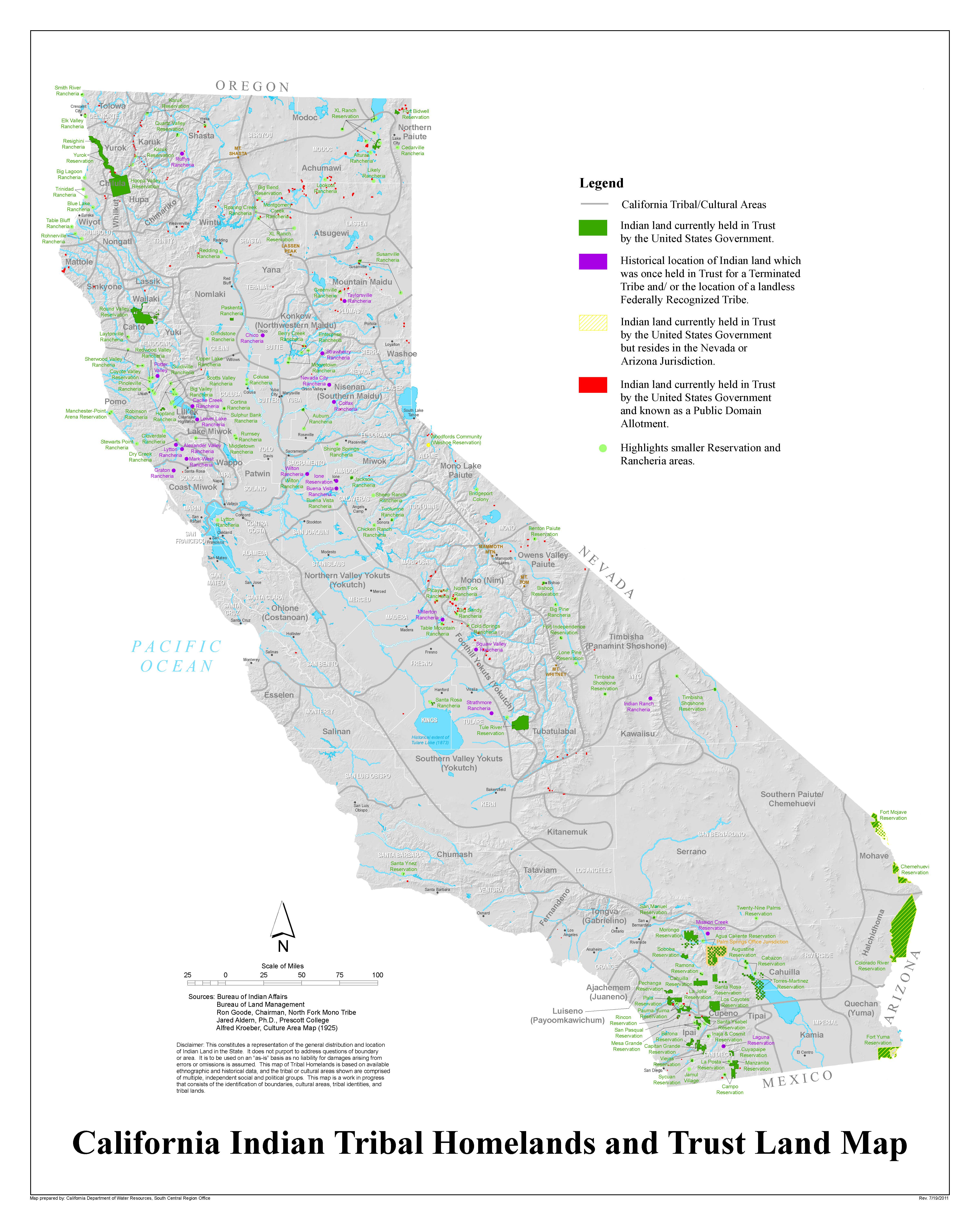
–if the federally recognized areas to which actual indigenous residency has been shrunk “Indian coutnry” to a rump presence that disperse one hundred and nine federally recognized “tribes” across nearly a hundred separate Rancherias, allotments and reservations in a geographic marginalization that the Native Land map constructively emends.
9. The crowd-sourced map of course offers nations’ members of ways of staking claims to the land that they still continue to inhabit–if not rarely on current mobile or static maps. An overlap between nations and land claims are especially prominent, for several reasons, one has to notice, in the many smaller tribes and “tribe-lets” of the west coast, often lacking federal recognition, especially along the California coast, in specific, currently valuable coastal property. The problem of the cartographic marginalization of many tribes lacking recognition as tribes leave them without claims to territory in ancestral lands. Other tribes simply neither have native speakers or land set aside, placing them in a cartographic limbo of lack of land recognition without legal precedent.
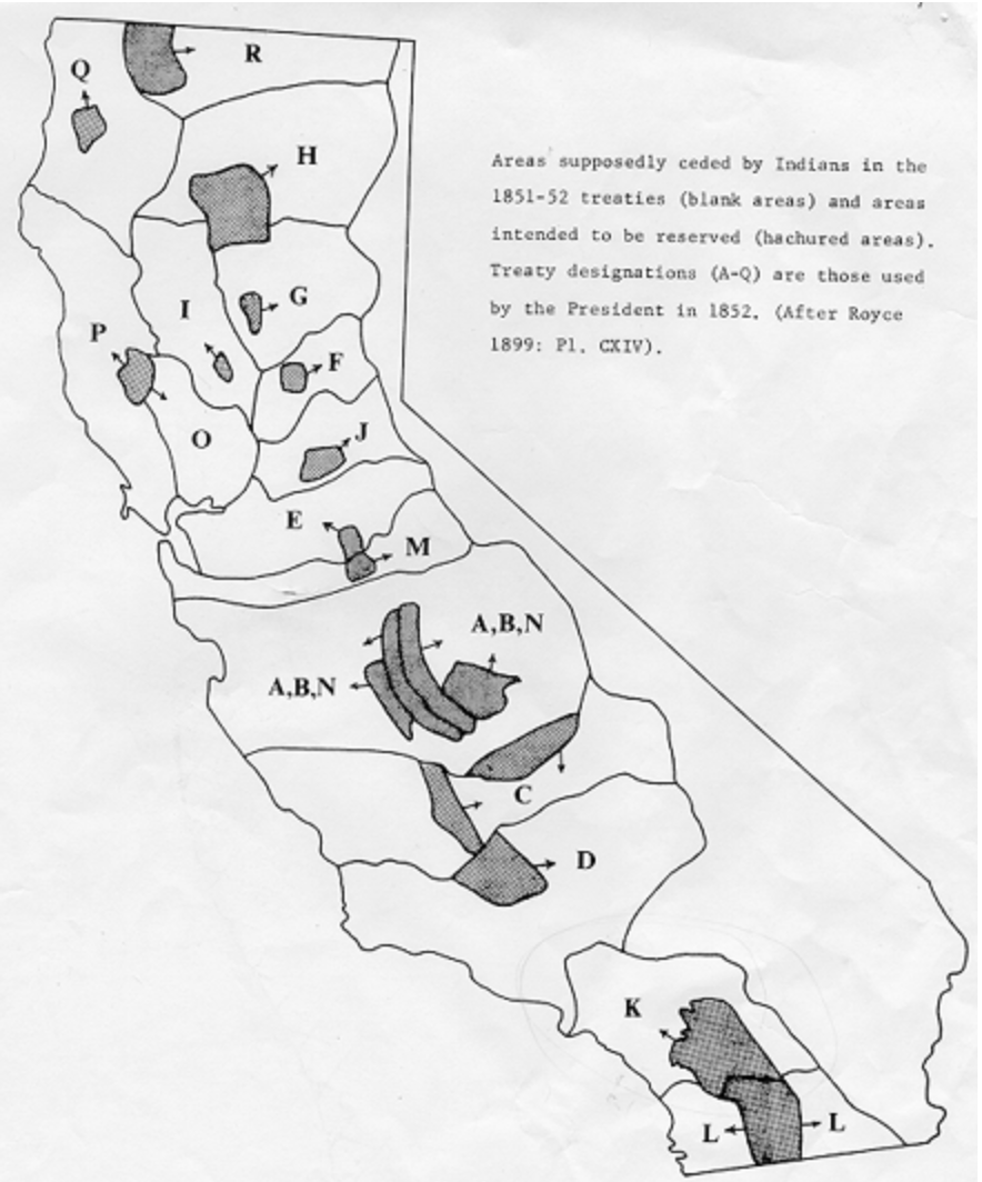
From the arrival of miners in California from the Gold Rush in the 1840s, land encroachments had forced indigenous inhabitants from most of their subsistence lands in California pushing them to the mountains; they entered into many unratified treaties with native inhabitants, ceding water rights and allocating limited fishing rights to indigenous inhabitants of the land; as California settlers seized native lands, Congress acted to confine tribal presence to”reservations” July 31, 1851, and March 3, 1855 on plots of no more than 10,000 acres, a number reduced to five by 1857, Fresno Farm, Klamath, Nome Lackie, Mendocino, and Tehon, and by 1864 relocated those resettled in Fresno Farm and Tejon valley to the Tule River reservation and sent those relocated to Nome Lackie and Mendocino to Round valley. Others from northern California and southern Oregon were sent to Hoopa valley, as all relation to former lands was erased by the growth of private property. The result was redrew the lands ceded to the government as “public lands,” radically reducing the lands supposedly ceded in 1851-52.

The marginalization of land ownership claims has a long history, but occurred as such claims were drastically rewritten during the Gold Rush, the first land grab for extracting minerals in western states. While estimates of a reduction of indigenous populations due to infectious diseases alone by a third from pre-settlement times in California, the pastels map of NativeLands eases one into the erasure of land-claims and ownership in the region from the systematic land theft sanctioned in California, where indigenous were killed between 1849 to 1870 with intensity of localized massacres by armed squads of vigilantes and groups of armed gold prospectors who expanded claims of private property in the region.
As much as being diffuse cases of land claims, the state issued bonds for militias to sieze “tribal” lands, as local governments placed bounties on Califronia indigenous, adopting a language of dehumanization and “extermination” and the recapture of lands, sanctioning the enslavement of “Indians” across the state, in the midst of the Civil War as an Act for the Government and Protection of Indians legalized slavery across the region as California was recognized as a state, creating at least 20,000 slaves at a stroke of the pen before the Civil War, by affirming “in no case shall a white man be convicted on any offense upon the testimony of an Indian” denied indigenous populations standing in any court of law.
Involuntary servitude or enslavement of “Indian” populations became state policy west of the Sierra Nevada, fostering the internalization and projection by prospectors of race-based categories of classification that helped defend and define whiteness on the western frontier state. This was soon evident in the stark reduction of the lands aAs prospectors entered the San Joaquin Valley and Sierra Nevada foothills long inhabited by the Miwok and Yokut, leading to state-sanctioned militia to protect miners’ claims, in “battles” as the Mariposa Indian War and El Dorado county campaign that was openly fought over staking recognizing the legitimacy of land seizures as claims. In the course of the Mariposa War, settlers signed a “treaty” with six tribes on March 19, 1851, ceding the Gold Country. as land grant universities collected some 10.7 million acres taken from nearly 250 tribes, bands and communities through over 160 cessions brokered under threats of armed violence, the University of California amassed its endowment from some 2,395 parcels of over 150,000 acres of land, by 34 cessions and treaties, as well as outright seizures, from across the state before World War I.
The Gold Rush has been situated in both an environmental transformation of the state, and an institution of new lands of rationalization of race-based extermination as Benjamin Madley details in An American Genocide: The United States and the California Indian Catastrophe, 1846–1873. California’s first Governor, Peter H. Burnett, predicted in January, 1851, “a war of extermination will continue to be waged between the two races until the Indian race becomes extinct.” as a “war of extermination” was demanded in local press “until the last redskin of these tribes has been killed,” as a Eureka paper in 1853 adopted a language of racial extermination while casting any proponents of treaties of land cessation as traitors to an Anglo cause. An early War of Terror might be mapped from the Sacramento River Massacre in Shasta Valley in 1846 to the Clear Lake Bloody Island Massacre in 1850 by a U.S. Army detachment in Lake County, or local militia in Mariposa County in the Mariposa War of 1851, as the meeting houses of Wintu were destroyed by miners in Shasta County, as Anglos collectively terrorized native populations conveniently classified as “ceded” as if in a rush to erase all memory of indigenous land claims from the map.
Difficulties to process this flat-out denial of land claims across the state contains one of the more relevant “under-maps” for blurring the boundaries of land claims as re-rendered in NativeLands. But the limits of land ceded for reservations was quickly reduced.
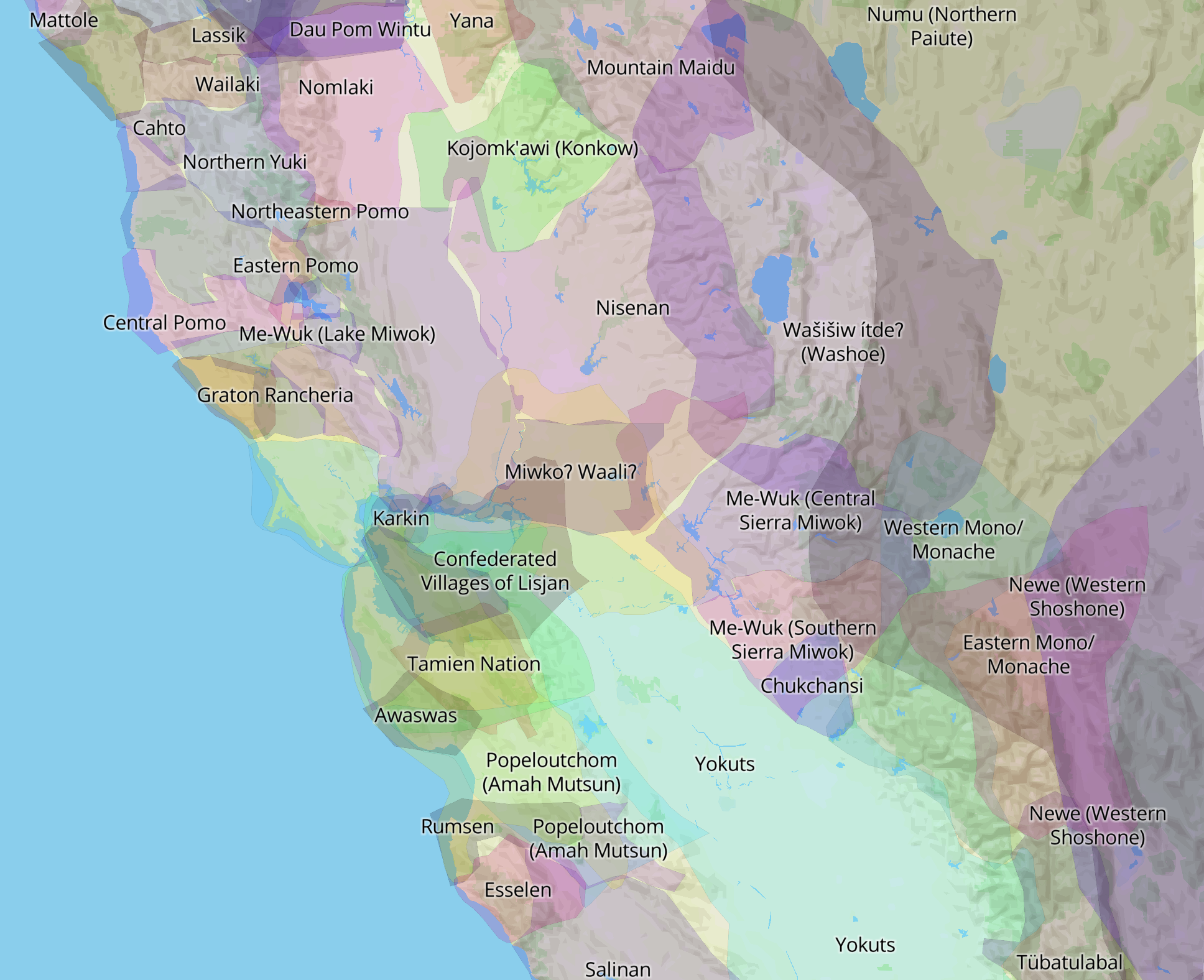
The maps striking overlap of blurred boundaries in these crowd-sourced maps immediately caught my eye as a place they might more peacefully rest,–and not only because it was so nicely aestheticized in ways that left me thinking this was a map I could enjoy reading more. The chromatic overlap of clusters of colors seemed so artful to urge one to zoom in, reveling in how regions overlap to pose parallel and quite alternative claims in the same frame of reference, rejecting the notion of a clear border as the nation seems to be haunted by one: the overlapping claims of migrating boundaries indicated the possible overlap of seasonal migration or parallel land claims. I questioned what relation this had to crowd-sourcing, but detected an intentionally approximate and slightly obscure removal of blurred boundaries from the coordinate system of colonizers, even as its crowd-soured nature affirmed the continuity of indigenous presence across the state, in contrast to mapping a landscape of genocide.
While some eighteen treaties were negotiated by the United States government before the Civil War with Indian “nations” to secure title to public land and create lands reserved for Indian nations, the alternative between “domestication” and “extermination” framed public debate. But the “treaties” were rarely signed with anything like clear knowledge of bounding ‘protected reservations’ or the denial of access to newly titled “public lands” from which tribes were displaced. The Decolonial Atlas continue to challenge viewers to synthesize the extent of dispossession over a longue durée that can barely be processed or grasped by snapshots of the grinding process of the wheels of disenfranchisment–

–we have struggle to tally the erasure of claims to land that were lost in anything like an ordered way as an “impact of California history on Native Lands,” a “replacement map” that can only suggest the difficulty of totaling the extent of rampant genocide across the state that in many ways distinguished and defined California state politics and property law in the nineteenth century, and may demand attention as a laboratory for the future campaigns of extermination by which the twentieth century was defined.
Even if the map is by no means complete–many indigenous were exterminated without treaties brokered to be broken, and the extent of land theft is difficult to map on clear lines, if the cumulative effects and scale of such widespread dispossession of lands is difficult to chart across the state in meaningful ways.


The eliminating of boundary lines Native Land features prominently are key to replacing our current maps, and our historical awareness of loss of sovereignty across the state. The have been left quite intentionally approximate but evolving–acknowledging how many displaced communities may be present in regions of other ancestral homes. Blurring boundaries, the Native Land maps say, will not seek to re-establish or perpetuate grounds of sovereignty analogous to other maps of sovereign states, but to better tell stories about the territory and our relation to it, and to question if any definite boundaries should exist in our maps. While geolocation is a bit anathema to many indigenous maps, lest they disclose information that might invite in others to sacred or historical lands, and in so doing undermine the struggle to preserve local knowledge of forested lands still used, these maps are sensitive to not wanting to encourage searches for artifacts, and ruins or artifacts, already often despoiled.
10. The cultural patrimony of the landscape and forests also needs defending, and the re-mapping of California and the West suggests a re-placing of prominence of native presence in the landscape that make it a far more living one than the current California, despoiled by pollution, paving, and increasingly fires. As the increasing urbanization of California in the twentieth century pushed the search for drinking water for growing cities into the interior and Sierra Nevada, once allocated native lands were pushed to the center of water disputes across the state, as Damon Aikens and William Bauer have noted, among others, and the demand for urban and industrial water alike came at the direct expense of what were once native settlements and lands: indigenous communities as the Sierra Miwok living in Hetch Hetchy and the Owens Lake were flooded to allocate a supply of drinking water for populations of San Francisco and Los Angeles respectively, as well as the agricultural expansion of the Central Valley, again the big losers in the calculus for diverting and reapportioning rainfall across the state by redirecting surface water flow; Owens Lake was outright drained as if it were a reserve for public use, and the flooding of the Capitan Grande supplied San Diego hydroelectric power as the city grew.
This is almost a secret chapter of the state’s environmental history. Both the Ahwahnechee and Tuolomne Miwok had shared the region of Hetch Hetchy Valley that John Muir praised as an “acorn orchard” of natural beauty, if it had long been managed by both Miwok bands through controlled burns to boost the output of seeds of black oaks across the valley. The Paiutes who had built irrigation system across much of the Owens Valley to grow tubers and seed grasses as a basis of settlement only became arid as ranchers appropriated its water. But the submerging of the “orchard” in Hetch Hetchy and the arid void of Owens Lake were cascading effects of how demand for urban electricity and water cast long shadows across the state’s interior that boosted collective amnesia of native land claims and the repossession of both valleys and erasure of long developed ecosystems beneficial to both lands.
The massive give-away of public lands was a windfall for creating reservoirs and dams, a bonanza that stimulated “public” building projects across the state of California before and after the New Deal to feed growing cities, in a reshuffling of environmental resources and assets that set the basis for its boom in projects of earth-moving in which indigenous populations were decidedly short-changed. The environmental transformation of much of California began from the expropriation of indigenous lands, in a circularity of laying claim to native land that boosted private property. “A map of reservoirs in California follows the contours of Indigenous land,” Damon B. Akins and William J. Bauer observe in their award-wining history of Native California, We Are the Land. The rather systematic flooding of Indian Country hand in glove with the Bureau of Indian Affairs may not even be needed to be mapped: despite opposition of indigenous communities to dam-building projects from the San Diego to Sacramento to Tuolumne Rivers, the first achieved through the negotiations between the city of San Diego and Bureau of Indian Affairs; the flooding of native lands and reservations in California for the “greater good” led to the construction of concrete dams 1923-61 across California, many now aging and rated in poor to fair condition, for urban growth: the damming of the Feather, Colorado, Merced, Sacramento, San Joaquin, Stanislaus, Trinity, and Tuolumne Rivers flooded ancestral lands of the Chemehuevi, Hupa, Maidu, Miwok, Paiute, Wintun, Yokuts and Yoruks. Rivers across the state were tapped for energy at indigenous cost, displacing each from ancestral lands rarely fully acknowledged: Bauer and Akins ask us to see the “hydrological map of the state is a map of Indian dispossession,” and one might push on their insistence that the map of surface water diversion is a “map outlining theft and erasure of Indian land” by casting it as a ghost map of lost or evacuated land claims that NativeLands tries to resurrect.
Ghosts in the machine of the long history of state building? It’s incumbent to preserve these parallel geographies of place, parallel geographies at the same time, and the theft or appropriation of lands for dam building reflect a reclassification of public lands that were in fact inhabited, as much as wilderness. We might note the presence of these dams against the claims rendered of land in apps such as “native.” We are, however, perhaps only become aware of them again as the dams are themselves age–as we debate an infrastructure bill, in San Diego County, Hodges, El Capitan, and Lower Otay are in “poor” condition and dams in Morena, Barrett and Lake Murray are in “fair” condition; after the 2015 disastrous collapse of the Oroville dam spillway, an audit determined more than half to be of “high or extremely high hazard;” three major dams in Southern California–on the Whittier, Prado and Mojave Rivers–could collapse in the flooding produced by the atmospheric rivers due to the surplus water created by arctic melting, endangering millions downstream and deflating property values.


Are we able to look at the map in greater detail, our attention challenged as we limp through an era of natural disasters? The divergence in how we map the state suggests an alternative history that eerily suggest the different realities in which many residents of the United States have come to dwell even before the Trump Era; it was the Trump era when maps became both far less meaningful as accurate tools, but far more powerful as persuasive forms of mobilizing opinion, this blog has argued and tried to show in recent years.
But rather than only asserting alternate realties, these maps are affirming a continuity across time that is deeply reassuring or restorative. For the presence of parallel worlds across the state, suggested in this map of the expanded Bay Area region I live, a region that has recouped unity due to highway systems that it once had in networks of trade, tracks the actually radically reduced landscape of habitation against the regions of past settlement.
I didn’t grow up bicoastal, but if I might have pretended to be Lenape on the shores of the Hudson in earlier years, the Native Land website offered a broader image of the lost land claims that echoed into the present topography of Long Island and along the Hudson River, a division of lands of Montauken and Merrick and Manhansets, Massapequas, and Hamonassets suggested a deeply reparative relation to reading the land, and reminding one of the wealth of the eastern lands from which indigenous claims were also purged as peoples were forcibly relocated and the rich waters of the Long Island sound ceased to be areas of indigenous settlement–or almost ceased–unlike the territorial divisions imagined among “thirteen tribes” that divided the Island and its waters in the popular imagination.


Is there any surprise Walt Whitman of Paumanok celebrated the sound of native place-names as of spiritual resonance, almost romantically, as more evocative as indigenous lands systematically marginalized from the map in California? Whitman in his geographic poetics insistently returned to land names of indigenous origins as a toponymy fare more rich with meaning of place than the settler names of jurisdictions. Yet indigenous were omitted and excluded from the nation and national census, and considered “foreign” to the nation-state, in 1850, the poet self-described as from the fish-shaped island of Paumanok celebrated his national song of transcendence as “starting from Paumonok,” “Isle of the salty shore and breeze and brine.” It is indeed as the site from which his poem starts, and he boasted to join the nation as a whole, from miners in California to the Dakota woods to the southern savannas or Manahatta, “my city,” and its “populous pavements.” As populous as the pavements in which he discussed his companions as “surging Manhattan’s crowds,” the island was far from uncrowded with inhabitants as readers might imagine.
Whitman’s own abundant toponymy in his national poetic geography barely broaches the range of places and settlements in the crowd-sourced regions, even of those noted in the very valuable map of Long Island in Native Land, charting the shared boundaries in which fourteen groups of Indigenous have lived and continue to live among the densely populated island, where several soverign nations also exist. The blurred boundaries of inhabitant on the island from Canarsies to the Shinnecock, include not only th Manhansets, Massapequas, Nissequoques, Rockaways, but the Matinecock, Montaukett, Setlacott and Unkechaug still sovereign nations on the Island, as, on or near the broader waters of what we call the Hudnson and Long Island Sound, the Shinnecock, Manhattans (Lenape), Linni Lenapes, Delawares, Pequots, Quinnipiacs, and other groups. Faced by a lack of information or organizational guides of existing records, local Long Island archivists have fulsomely praised the revisionary interactive maps for valuably providing “one of the very few sources that accurately depict fluid border lines” in the Island led recommendations from the Director of Special Collections and University Archivist of Stony Brook University to submit requests for land acknowledgements to the Library of Congress, as part of a reparations process, in 2021, emphasizing the value of boundaries of the interactive map as an alternative guideline to organize works difficult to organize or locate in existing university collections.

Such place- and regional-names are often officially unrecognized, or lost due to forced migrations and consolidations, and the requests for land acknowledgements and finding aides are precisely what the founder and administrations of the crowed-sourced if adjudicated website NativeLands.ca desire to see.
11. A lack of definitive boundaries serve to deepen our understandings of place on the map, in the words of Christine Luckasavitch-McRae, “to engage critically with colonial boundaries” and influence of settler colonialism on a global scale as we come to terms collectively to complexify of a relation to territoriality that includes an interactive component of indigenous voices too often marginalized. The question of staking land acknowledgements may be only a first step of sorts to reckon with the landscapes of colonization that are preserved and perpetuated in maps; by enabling students and all to use GIS in new ways to claim the idea of digital sovereignty by the format and style of online maps, and indeed to create an educational moment of reflection, in which the process of map-reading offers a base to rebuild community relations: they suggest the real interest of providing a gazetteer of Native Land able to be eventually recognized, one hopes, by states and sovereign entities as place-names of authority.
The illusion of a distinct set of native or indigenous cartographic competencies is an odd cartographic iconography to display ancestral lands. The claims of using open-source tools to illustrate places that were historically occupied are not indigenous map per se, using different modern cartographic vernacular that open source allows, but renders a sense that seems to convey an inescapable of the sense of occupying and moving through space–a sort of virtual recognition of spatial mobility–absent from traditional cartographic tools and forms. Or does the iconography erase a senes of indigenous contribution to shaping cartographic records of place and its inhabitation?

However, the map, in which one can drill down, conveys a sense amenable to the performative relation to place, and indeed the progression through space, that is organized and oriented around fixed toponyms, but rooted in inhabiting and moving through spaces, rather than fixed bounds.
Despite the value of open access and familiar processing of sites of belonging, the value of place-names on the map is to a large sent erasing the different cartographic competencies that indigenous had to the land, and the different ways that time mapped on to space for them. This map is, we are reminded, not far at all from the iconography of conquest. The definition of “treaties” or concessions on the same map enriches its content if crowds its narrative, a topography of “secession” or “ceding” lands by strong-arming or gunpoint which seems to be on questionable grounds as a tallying of precedent–if the cessions may be a bit of static on the appreciation of ancestral lands currently inhabited, they illuminate the range of tribelets or communities often given a seriously short shrift in cessions ceding land on the west coast.


12. The definition of Traditional Territories in Canada has deep traditions, as ancestral lands claimed by first nations. In British Columbia, whose capitol is Vancouver, 95% of the province is unceded First Nations territory–“unceded” to remind us that none of the traditional territory was ever legally signed away to the Crown or Canadian government–as “traditional” lands. The blurred boundaries of the map created in Open Text BC includes use a pixelated boundary to clever effect to suggest that the boundaries were never clearly drawn in a map that maps onto space and time in ways that we want to think of as a straight edge.
The blurred boundaries of British Columbia, from an indigenous perspective, map not onto a territorial mindset, but a riverine network, and a relation to the ocean on which the riverine network opens. Rather than existing in relation to the place-names of Canadians, the ancestral people, family lineage, and past names of the land are given new vitality and presence in this educational textbook, as a way of learning a different relation to the land, a project at heart of decolonization but also of re-appropriation and a work of not only making strange, but reorientation, to a network of roads and rivers that were not primarily understood in terms of transit among cities like Vancouver or Prince George or across property or boundary lines. This re-education bridges multiple cultures, and allows the diversity of perspectives on place to be held within the map’s edges, rather than ask edges to be internalized by the viewer.
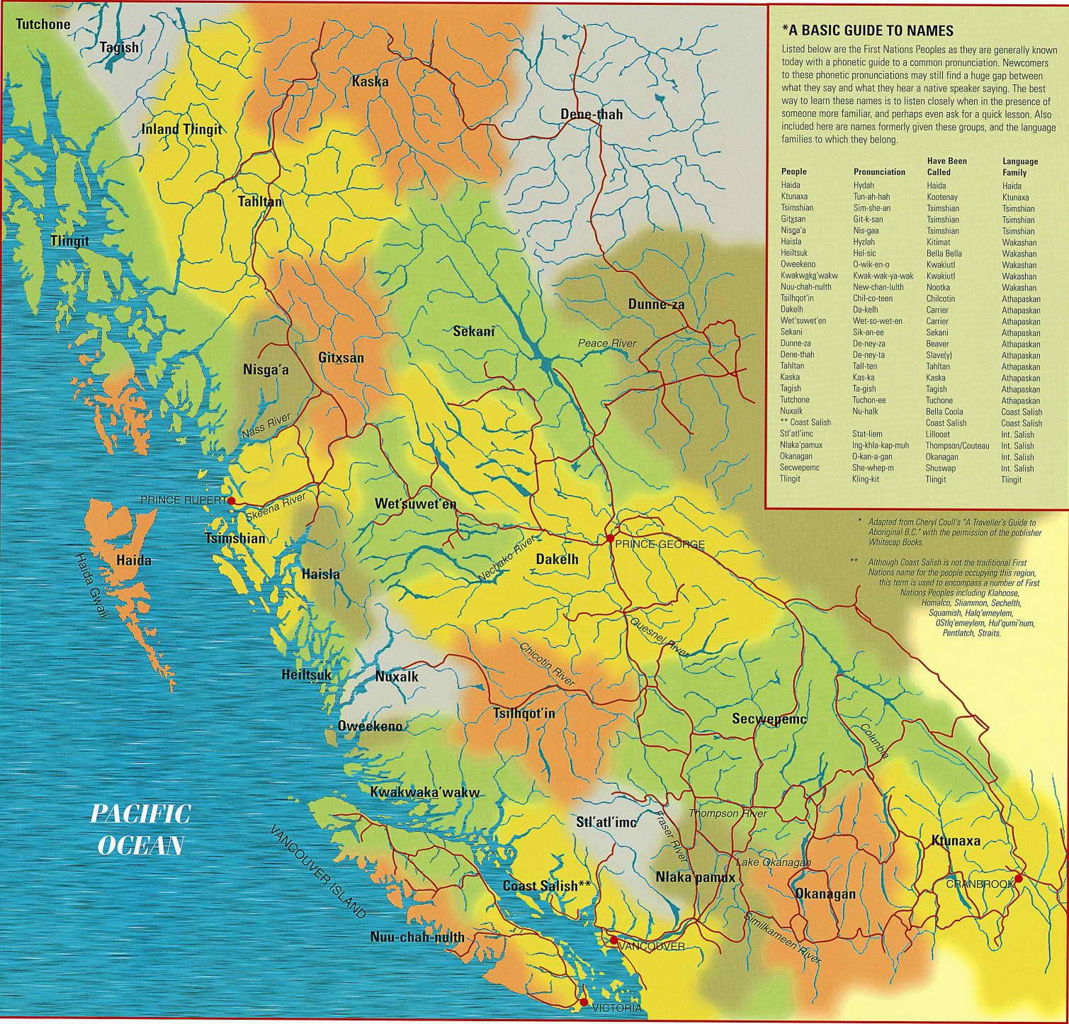
The value of these blurred boundaries are corrective here, but may suggest a blurred sense of occupying space or of preserving a sense of the crucial role of movement through space: while we are tempted to see the tribal presence as localized, or rooted in place, the removed from the senses of mobility, enabled by road-building and a paved environment of transit, the motion of indigenous presence across a region may be unduly rendered static as it is localized.
This is not the mapmakers’ intent, however, far from it.
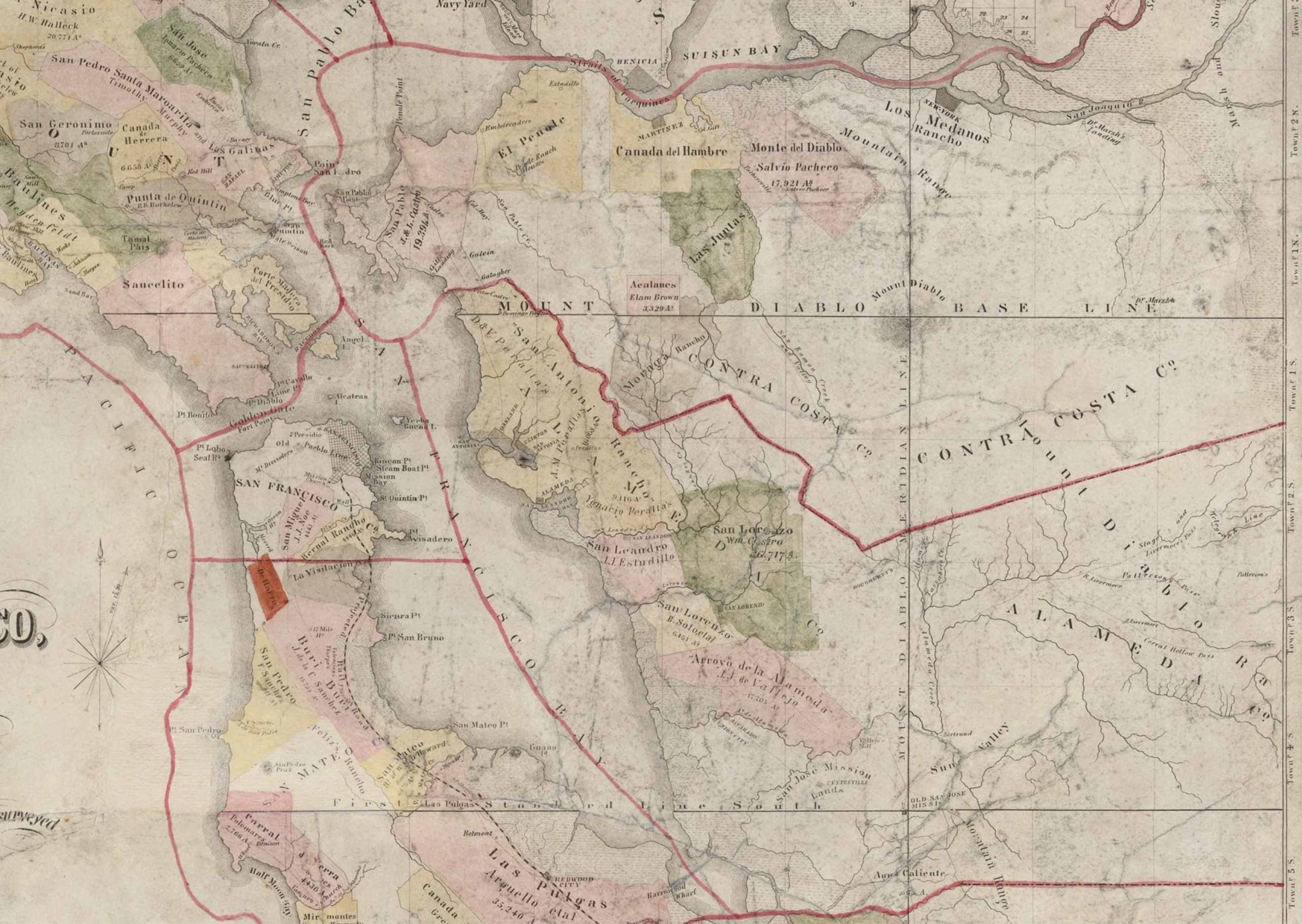
13. Where I live, in Northern California, the Gold Rush was in fact the first scene of the crime, an early scramble for mineral extraction that provoked a sanctioned if mad rush for land seizures, privatization, and despoliation of the terrain. The state of California famously legally ceded of multiple land grants have preserved title for Christian owners from its founding in 1851, bolstered by the legal conceit of a “doctrine of discovery” the title to lands of the old ranchos and missions as a territorial mosaic that was transmitted to Anglo owners along relatively set lines. Despite a relative pastiche of Spanish and indigenous names to title in these pastel-hued land grants and counties around the Bay Area, c. 1851, the maps lay claim to fixed boundaries and edges of what has come to be known as settler colonialism–
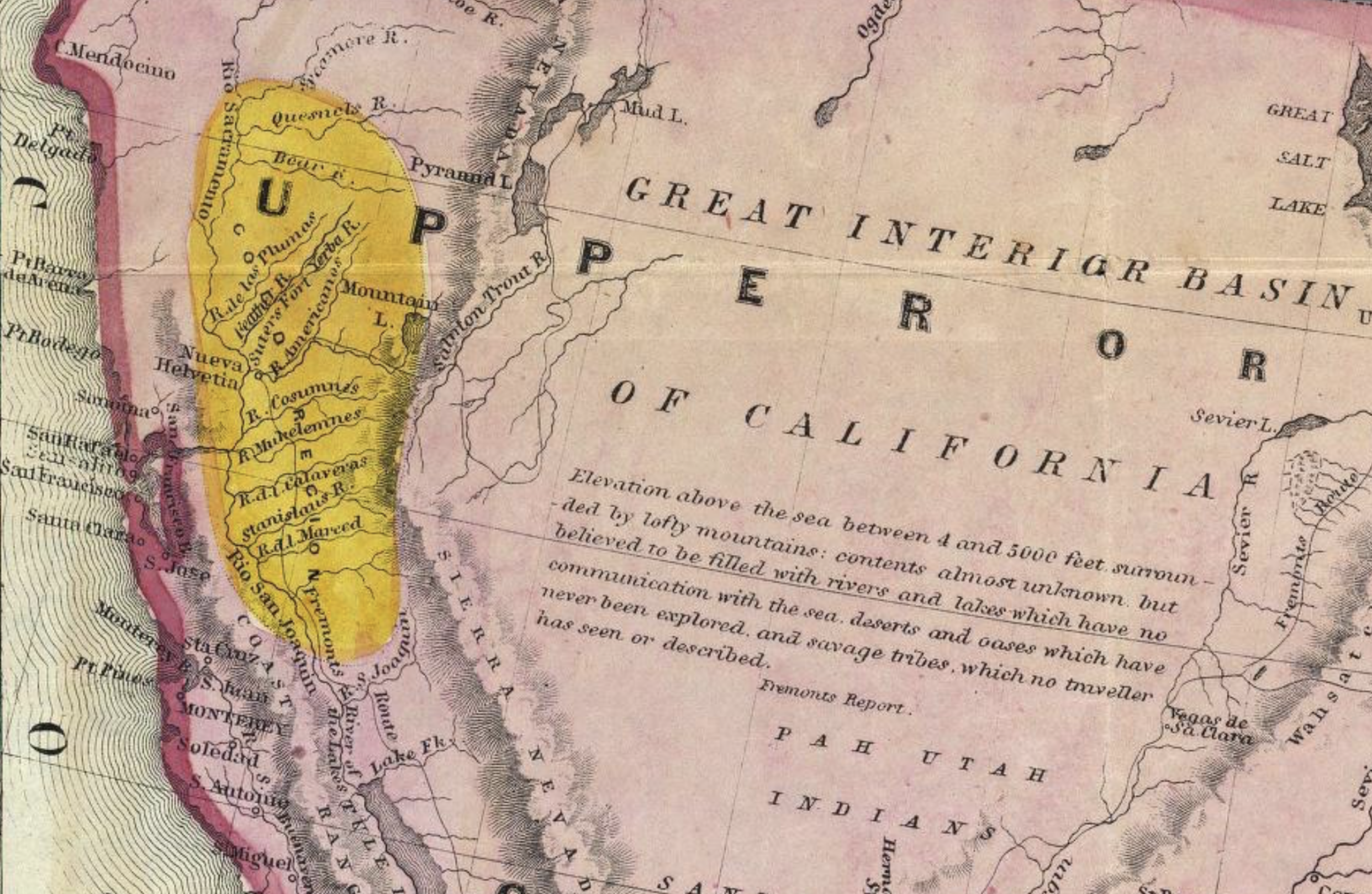
–and maps for those considering “emigrating to California” either as settlers or for business, in 1848 depicted the necessary sea routes to a land where a region indicated by a golden ochre lay inland from Santa Cruz, approximating a northward shifted Central Valley, in a mythos of acquisition that pushed all indigenous residents of Upper California into the interior, beyond the Sierra Nevada mountains, the sole province of Utah Indians, Mohauks, and other nomadic peoples, who had no title to the land.
The re-placement of Indians east of the Sierra Nevada in this 1849 preceded California statehood,, but would be reflected in the enslavement of all “Indian Lands” west of the Sierra Nevada in one of the new state’s first public decrees.

The location of the “Gold Country” wonderfully elides the four-color map with the color of value to be extracted form the land on which indigenous tribes lived, imagined as a relatively loosely bounded region on the map, intelligence of which dates back to 1578, but if reported by Spanish explorers never reached the Spanish court, but was now an open destination that is open to emigrants to claim as their own, in a region filled west of the Sierra by “savage tribes which no traveller has seen or described.” The “open kill” policy on those who lived in lands were seized and settlements destroyed in the Gold Country led to disparagement of native peoples who ate tubers, roots, and potatoes as “diggers,” evoking the seventeenth century English diggers who had preached the abolition of property and commerce. Was the derisive and false denigration of indigenous tribes as lacking private ownership an implicit denial of their rights or interest in holding private property or land? (When that term was openly reclaimed by the anarchist theatrical collective in San Francisco’s Haight-Ashbury about a century later more prominent was the seventeenth-century vision of a society without need for private property, boasting free association and free food distribution networks and rejecting private property.)
The absence of land ownership made disenfranchisement self-evident in the cartographic marginalization of indigenous living east of the Sierra Nevada. The sole location of indigenous populations in California outside the Gold Mining Region where settlers were directed was strategic and not accidental: as “savage tribes which no travelers has seen or described” were far from the region that promised value and prospecting in its golden glow, the tribes were in apparently deserted lands.
In fact, populations of native tribes by rangers and militia led to violent expropriation of lands. Long protected by the terrain of mountain ranges, from which they were not displaced or attacked by Spanish or Mexican colonists, tribes were violently forcibly relocated from villages and lands claimed for mining, removed in almost systematic fashion by privately organized groups of rangers to defend and protect Anglo claims to valued land. By shifting all tribes east of the Sierra Nevada, the map directed migrants seeking the Gold Region had emptied it of the indigenous inhabitants who had previously lived their undisturbed, voiding land claims and displacing them to the desert from the glittering Gold Region around the Sacramento River.
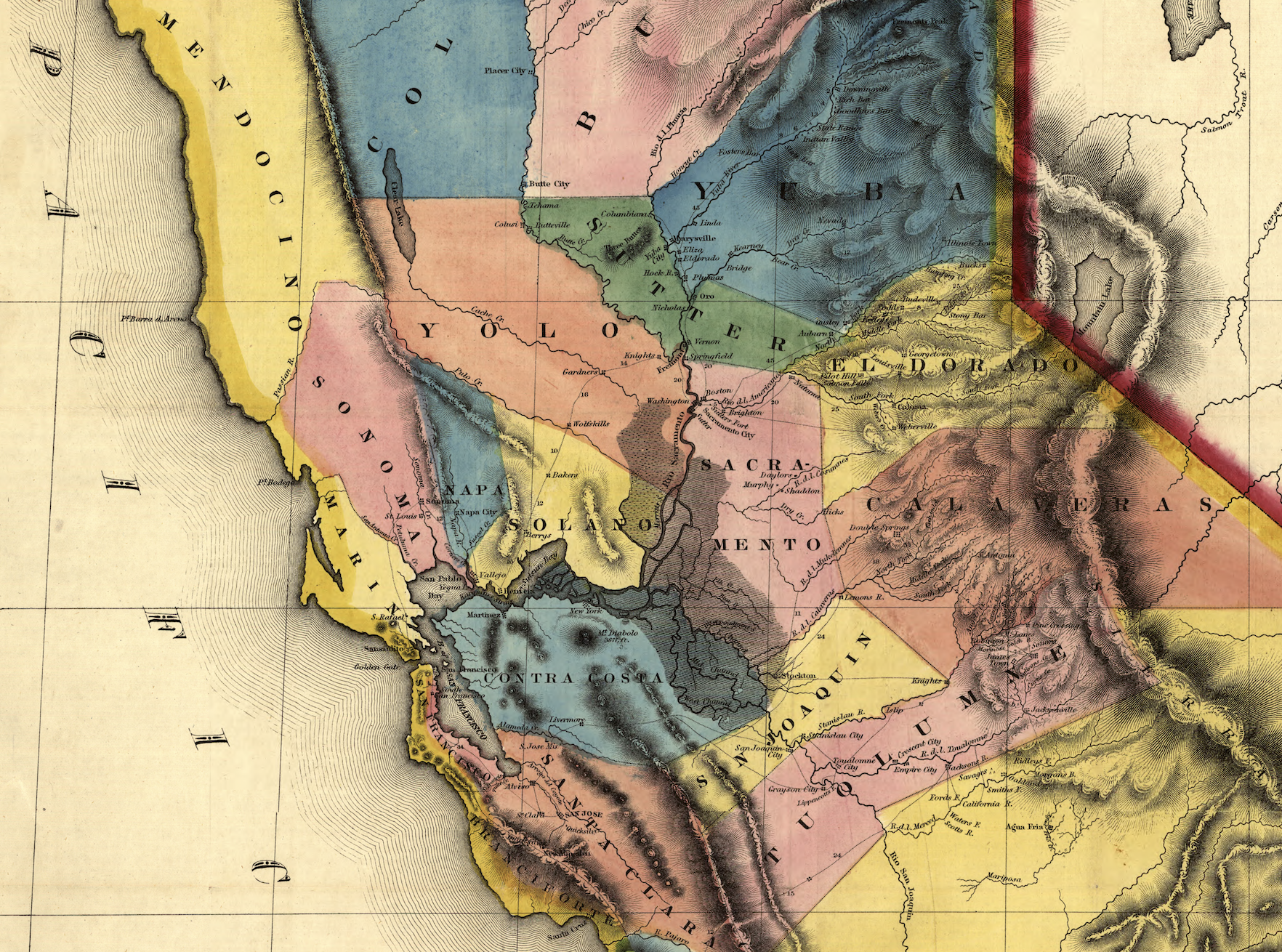
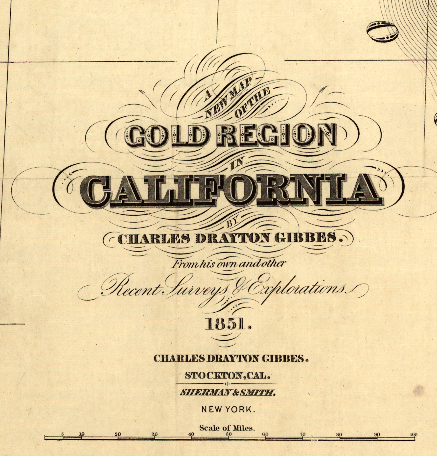
The link of extraction to the omission of land claims indigenous peoples is abundantly evident in 1849. Preserved by the “Doctrine of Discovery,” the county lines that combined, as if seamlessly, native indigenous sounding and Spanish names melded the geography of ranchos and missions to the property claims, casting indigenous as without title on the map, and omitting those nations without property rights from the map, save in as evocative place names–“Yolo” or “Tuolomne”–now converted to areas of future land settlement by farming communities and vineyards, often, as “Sonoma” and “Mendocino,” named by Spanish navigators in honor or Antonio de Mendoza, Viceroy of New Spain, all but expunging indigenous presence from the territorial map. Many counties are bright yellow, but in this New Map of the Gold Country, the “Gold Country” announced with decorative fanfare in its title is not bound as a destination, but implicit in the logic of extracting capital form the new borders of the surveyed land.
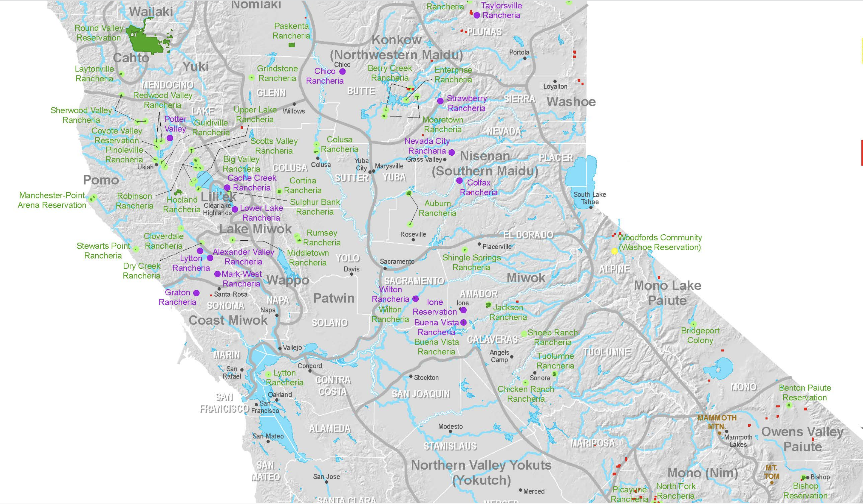
14. Over the past few years, California’s Native Heritage Commission digital-atlas was designed to help students to “visualize California before, during, and after European occupation” describes the state of California as a site of “colonization” by both Spanish missions, Mexican land grants, and American Genocide, trying to grasp the increased confinement of indigenous by a range of settler acts, a complex project of tallying the reservations and cessions of land within the area of California to help process the problem and clarify the perspective of current indigenous inhabitants to the state.
Indigenous communities are marginalized in lands often separated from agriculture desirability across rancherias, reservations, and allotments of different legal status and recognition, assembled by the California Native Heritage Commission as a way of tallying effects of cartographic marginalization of land claims in a compelling educational resource, explicitly not for drawing boundaries with legal status or for legal ends, but an attempt to process a double-edged narrative of loss and survival of ancestral lands–themselves of course long literally obscured from the map, of course, long before the state.

The Arc-GIS base map provides a middle ground to negotiate this history, sifting among treaties, lands of confinement, and currently recognized lands, against a base map of ancestral claims, a basis for orienting viewers to heritage and history that seeks to be ethically sound as a way of processing a terrible genocidal past, as if to create a sense of common ground, using an optimistic light green to describe lands promised to tribal entities as reservations, linked to founding documents and treaties as a valuable educational resource.
But is the format of GIS layers the best way to orient one to further exploration of the indigenous presence in the state, or is it describing space in the categories “California” and the United States government bequeathed on the historically “tribal” indigenous entities that it recognized,–
–often suggesting the scale of lands bequeathed in the Central Valley that are far more expansive than the lands of current reservations and rancheria, and indeed only in sharp contrast with the current allotment of recognized “native lands”?


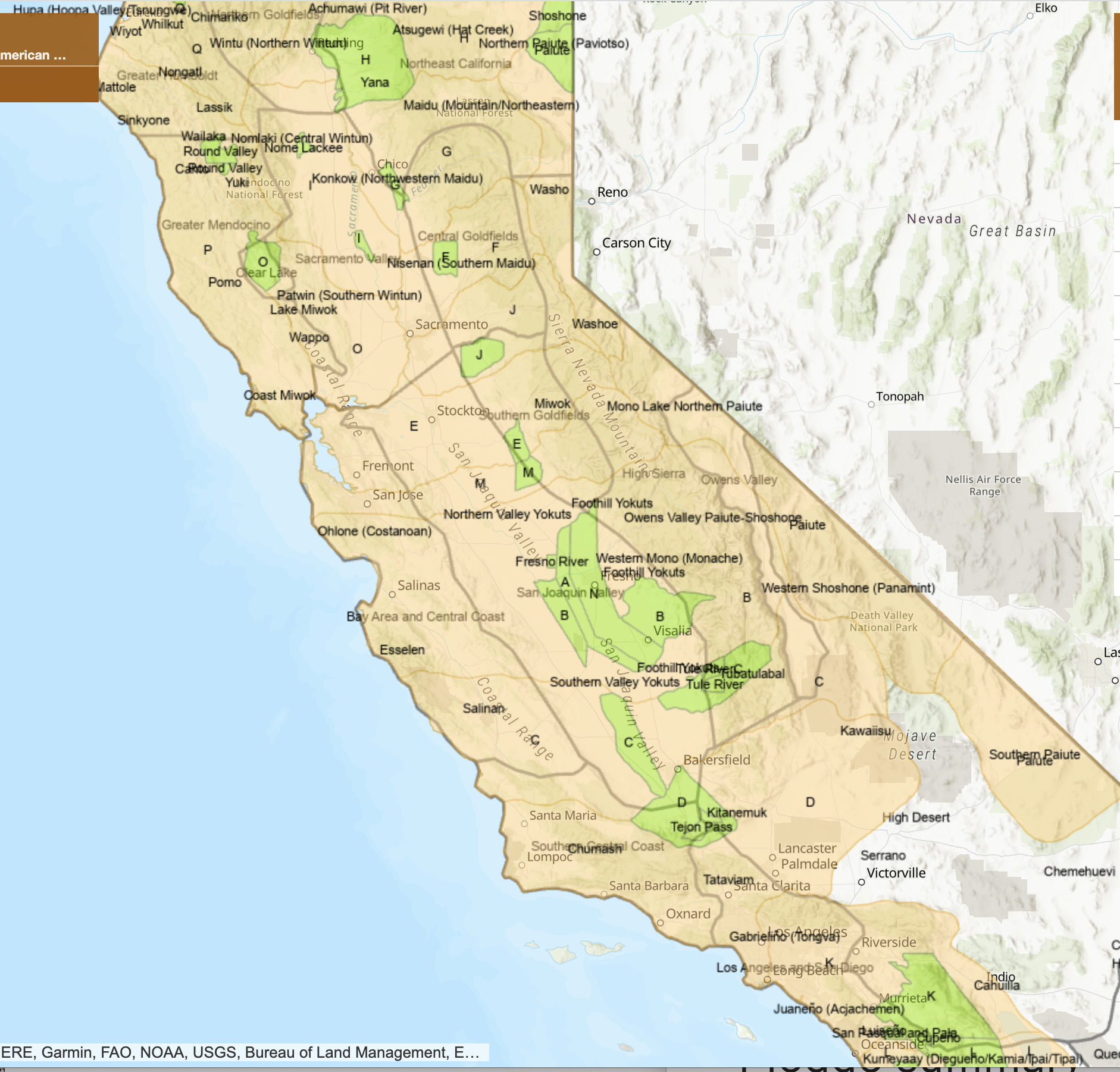
In the “Tribal Homelands” map is in a western cartographic idiom, the overlapping place-names, borders and boundaries around the state capitol of Sacramento and Bay Area are confusing, hard to process, and downright unclear to the viewer eager to read them. Dense rancheria of local “tribe-lets” that were unrecognized in the past, suggesting a sense of dense settlement that might only exist on the map–if it is refreshing to see the ancestral lands assume new precedence in a familiar map. One returns to the local value of the view on the current map, announcing the presence that has been so long marginalized, and indeed emphasizing the fragmented isolation of rancheria, isolated in points of limited access to the ancestral lands that have been so drastically transformed.

Is crowd-sourcing a better way to achieve buy-in to a sense of stakeholding in a regional map? Or is this sense of DIY boundary-drawing not really the point, as much as the fluidity of the boundaries, which pop out for each region, lending an integrity to Coast Miwok, Oholone, Southern Pomo, Plains Miwok, Sierra Miwok, Northern Yuki and Patewan, among others, as a click, invests a far greater sense of presence and agency on the map, and indeed raises the question of how it might demand to be translated, if possible, to paper form, and to be taken off-line.
15. As much as renaming buildings, schools, and universities, this might be better cast as a deeper project of re-placing California. The re-placing that such maps would offer seem more of a rectification, symbolic but powerful, as we are haunted in the nation by the recent import of the nationalist myth of a Great Replacement, a trick of recasting mass-migration due to globalization as a conspiracy of elites in France from 2010, and designed to dilute if not erase French culture: appealing to the sense of entitlement to the lands they live in, and see as their right to preserve in echoes of a heimat or homeland, a concept that is rich in German Romantic poetry but was translated from the poetical to the political as response to industrialization and a loss of social status if not of homeland.
If the roots of heimat in an early modern sense of the German nation and vaterland gained new purchase as a form of patriotic defense in the industrial era, and a rejection of alienation of one’s relation to the land in industry, the Great Replacement replaced such emotional ties with an apocalyptic vision of the humanitarian crisis of mass-migration in a globalizing world: removed from open associations with Genocide, the theat to a racial order has been dignified as a theory of the “Great Replacement” in France, in ways that deployed many of the terms of the French Resistance–one speaks of elite “collaborators,” and elsewhere, seeing immigrants as “occupiers” thT channel the luddite xenophobic calls of the right-wing. ONE THINGS OF English Conservative Enoch Powell’s retrograde call for the repatriation of immigrants in 1968 to dis-enfranchised Midlanders threatened by the arrival of those Indian, Pakistani, African, and Caribbean migrants blamed for disrupting an economic status quo. Such alarmingly increased currency of Powell’s derogatory terms gained new currency in Replacement “Theory”–in America, among White Supremacists in America–in a mirror image of globalization.
This has, of course, more than conveniently ignored the Genocide already occurred in California, from the mid-nineteenth century. The recasting of global migration patterns as the agency of elite capitalists aiming to disrupt an economic status quo adopted imagery of fear attacking “collaborationists” of complicity in cultural and racial substitution to inspire reflexive repulsion. The apocalyptic vision of the future of race relations as a national apocalypse were embraced by white supremacists readily, as if finding agency in defending a racial order as a response to global mass migration.
Yet perhaps “homelands” would be well to be remapped, and contemplated at large. The cartographic project of remediation by recognition of the scale of a genocide that set a model for others in the twentieth century would instead provides better tools to remember a genocide that has already happened. As much as Replacement “Theory” has been fueled by truly toxic questions of whether the “superiority of the white stock will persist in the future,” and what Ludwig van Mises, an immigrant Austrian-born economist, the “civilizatory achievements . . . of the white Caucasian race.” Von Mises critique of open borders has become central to libertarianism: he contrasted immigrants “who adopted the English language and American ways” as an economic disaster of open borders, fearing immigration without assimilation, used to tag debates about immigrants in the age of mass-immigration, and led many to advocate rapid assimilation of migrants in small–“not . . . too great”–numbers as a way of preserving the racial or cultural identity of the nation.
The maps that might unmoor us from a narrative focussed in the nation that had displaced and disenfranchised past inhabitants, in the guise ownership and property claims, might help us asks us to attend to the tragic consequences of displacement and private property rights, if only to process the ethical qualities of historical processes that have for too long remained unmapped and in the dark shadows of the state, or in a conveniently obliterated past.


Having finally disposed of the metonymous turkey, am digesting this (unmediated) feast of historical greed and epic hypocrisy, notably in California and the Carolinas.