
HU–“Huster’s University”–is an “educational platform that teaches you skills and strategies and encourages you to achieve financial freedom and live your dream.” Moving between reality and dream in the fuzzy space of the internet, it allows you to assume the identity that you always wanted, if you are a man: it has taken to promote itself in its recent incarnation as “The Real World” as the only real access to a world of Money Makers where they can lead a fulfilling life. It promises to lead all who enter to an alternative reality, mentoring users who are able to click on a button to reach “the portal to escape the matrix.” Billing itself as an online portal for those who are making six figures every month, it is a creation of the internet that offers no certificate, but a fast-track entrance into the gateways of an alternative world that escapes one of increasing wealth imbalances in a world where one only needs to learn the skill of “making money,” in a modern updating of Trump University–a sort of precedent for these new influencer’s successful outfit, if the life skills that Trump University offered were never specifically explicitly tied to the sex trade.
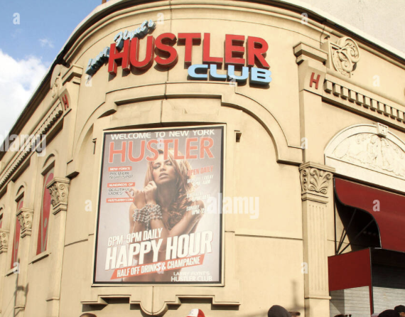
If the Hustler Club was a sign of the ascendance of the porno industry and trade in New York, an actual destination and marketplace of its own marginal sort of seediness, the gutsy appropriation of a marketable good once imagined on the fringes of urban life have gained a new online currency as an actual hustle, a form of work that exists only and fully online, but in its online form erases and elides its true and increasingly dangerous human cost, as a space through which bodies move and identities are masked and marketed in something like a perpetual Happy Hour. If the tongue-in-cheek debasement of the term ‘university’ seems to grasp a newfound status and sleek sense of enterprise among true businessmen, the hustle of Hustler’s University is a specifically toxic creation of the online world of men and boys, a promise of satisfaction and attainment that Larry Flynt could hardly have foreseen.
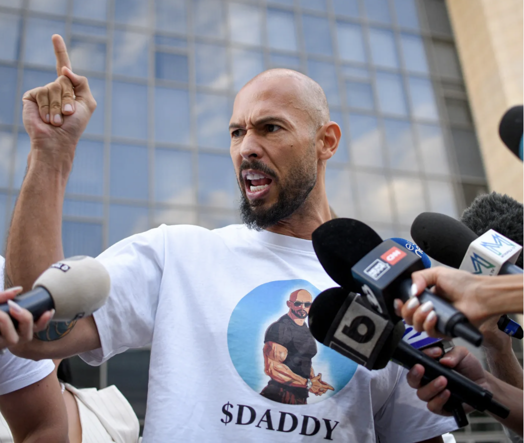
The toxic masculinity that the Tates long purveyed–what might be called “hegemonic masculinity”–was the core of their charlatanry, encouraging exploitation of the most vulnerable underage women, often displaced refugees, even as prominent figures of the American alt right news, from Ben Shapiro to Megan Kelly to David Portnoy have tried to distance themselves from the dropping the criminal charges the Tates faced in Romania of trafficking and money laundering. Cigar-smoking Andrew Tate, his feet perched in luxurious leather loafers atop a veneered desk, puffing on a cigar and looking out from this alternate world that he has mastered and you can too. The promise of being fast-tracked by having access to real-world entrepreneurs, to celebrate their achievements, rather than going through life as a wage-slave prole. And as he cultivated the persona he gained on social media in ranting about women and feminism on the dark internet, a gleeful misogyny, singing the praises of “alpha men” suppressed by a society they are failed to be understood. The online avatar styled himself as “Top G[entleman]” or “$Daddy$” has continued to curry attention from Donald Trump, in a search for attention danced with The Donald, for whom he claimed he joined Twitter in 2017, and met with his son, Donald, Jr., in True Tower, soon after. Tweet suggest the chemistry of their online egos: “Do you understand that trump is the last hope of the western world? A literal hero against our destruction?”; “@realDonaldTrump Great job mr president! #maga”; “When I’m on a date if the girl says she doesn’t like trump I ask ‘why?’ She never has a reason. I correct her. She apologizes. We Fu**.” Soon attending CPAC in 2019, as a commodity on the Right Wing internet.
This was indeed an actual bromance, rooted in the kinship of scamming customers and casting oneself as a defender of hypermasculine values from the other end of the age spectrum. Tates’ relentless objectification and demeaning of women as a practice of self-fashioning became tools of trade, benefitting from real-life resentments via AI algorithms directing droves of young men to internalize from their misogynist websites abusive language and techniques of physical coercion as tools of the trade to turn their bad luck into skills to monetize. For Tate, the looking glass of a nexus of economic and actual porn that made up a Hustler’s life– Romania is not the hub of porn it was in 2015 or the start of the century, when high def webcams compromised the capital of porn by allowing a new adult entertainment landscape of streaming, the reservoir of desperate camgirls had offered a pool for the Tates to exploit in their new site of residence, fed by the growth of human trafficking on the border of Ukraine on a new scale difficult to monitor. If the porn industry is a global purview nourished by online services, providing a wide range of services for clients that are increasingly able to be mapped by anonymized data, the recent growth of the 18-24 year old users has been striking–even as the over thirty five group continues to drop.
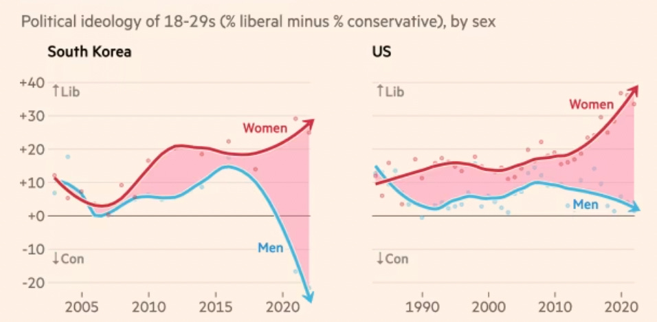
Tate became an online puppet or avatar for making millions, as pumped up as the suntanned face of Donald Trump became an icon of patriotism. Lifestyles of the Rich and Famous was on steroids at Hustler’s University. For the Tates both embraced the endemic wealth inequalities of the present-day world, and promised a ticket to the gold-plated world that lay beneath a heightened map of wealth inequalities, a ticket to a world in plane sight, only waiting to be hustled by those ready to swallow its red pill. The algorithms that have directed more and more young boys aged eleven to fourteen that promote misogyny have only grown with the rise of AI platforms–some 69% of English teens being exposed, per Vodafone, to misogynist website from unrelated searches, exposing over half to misogynistic online platforms of the “manosphere” that the Tates occupy the marquee, who have absorbed sexist language that schoolteachers and parents have both noticed. Almost 40% of boys between sixteen and thirty believe that feminism has done more harm to society than good, and 21% of the same cohort have a favorable opinion of Andrew Tate–a third of men arguing that he raised important points about the threats that feminism has created to male identity. The result is that they benefit from nothing less than a polarization of attitudes to young men and women to gender equality that maps onto the split in political beliefs–in which the isolation of the online life of surfing the web terrifyingly mapped onto a political divide in the UK and Unites States alike. This was the world of the Tate Brothers, targeted to lonely males and determined to protect the world from gender ideology.
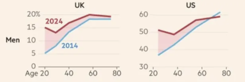
Young Men and the Populist Right in the United Kingdom and United States/John Burn-Murdoch 2024
Untethered from the economic world of payment processors like credit cards, it offers alternative banking systems as a pathway to personal responsibility, a “way out” of depression,–promoting easy entrance to a lifestyle of tech millionaires, a dumbing down, one might say, of the real university, for those who disdain them. The smooth entrance to a world of wealth in a frictionless world of the web is born of globalization, granting the Tate brothers–38 and 36 years old– the mobility of online life that made them seem robust digital nomads The influencers who champion their unrooted status are a creation of a rootlessness the internet allows, the holders not really of credible opinions, but constituencies that have allowed them to enter the circuit of the Alt Right as useful tools to corral followers, moving across boundaries in possession of seven passports.
When Andrew Tate returned back to Romania, head hardly between his tail, he appeared for cameras outside the Bucharest Tribunal, a Miami Beach version of Steve Jobs, back to Romania again, boasting he was “happy” to be back, as Romania lost its status of visa-free travel to the US–and as Andrew faced a civil case threatening to reveal how she had been coerced into sex work that the Tates didn’t want to go public. Despite their large following in the alt right circles in the United States, the Tates walked back to Romania, allegedly to “prove our innocence” as victims of a “coordinated attack” that had led to their house arrest over two years in Romania, where they fled an investigations of abuse in the UK–claiming they were “never going to leave” the new home they had successfully redefined themselves as self-made millionaires from a social media empire, and posed as useful icons of masculinity for an online empire that fed political divides in the US and UK.

Andrew Tate Confronts Media after Leaving Police Station in Romania, 24 March 2025/Vadim Ghirdă/AP
We have trouble connecting the role that broadcasts to his 10.7 million social media followers and the fragmentation of politics with the victims of sexual violence he advocates, but the it rests on the geography of resentment that social media fuels, in which Tate can pose as a hero of the alt right’s ideals of masculinity, evading national laws but benefitting from human trafficking to trump up hyper-masculine images of resistance that so verges on cosplay to challenge mapping.
Is this not the image of a self-made man, or is Tate’s enactment of resistance so slickly staged for a manosphere as a response to political vendettas staged by USAID organizations, DEI initiatives, and men so sadly weakened by feminist orthodoxy to be mindless tools fostered by an internet that recasts allows human trafficking crimes as a Galahad-like quest for virtue? Tate evaded the law in an eery miniature counterpart to Donald Trump’s evasion of the law, a sort of cameo that confirms the need for hyper-masculine vigilance social media helps internalize among a growing section of young men in our society. Having won fame from the emergence of a beating of a contestant on a social media show that he claimed entirely consensual, the Tates use truly pornographic references to discard all legal notions of consent, offering an app “Real World” to purvey instruction to teenage boys seeking to become “real men” as a question of claiming their own rights to resist gender roles of “socially induced incarceration” they promise to free their paying clients, casting himself at the center of an international web of enrichment outside legal authority or social norms.
The victims of Andrew and Tristan Tate were terrified at the prospect of the brothers’ release from house arrest in Romania. Even if they had been banned from social media platforms, the platforms allowed their work to flourish, and they continued to purview their hard core misogyny online. Andrew Tate returned to a location where he was had successfully run an empire of global streaming as a lifestyle guru and social influencer–a pernicious position to the rest of the world but from a position as removed as the unregulated economy of the offshore. While Romania offers a high speed internet, the expansive “cam girl” industry in Romania emerged from the ashes of the porn industry of recent years, mutated out of the exploitative services that were a casualty of streaming, but has provided a new niche from which Tate can claim status in purvey8ing a Returning to the area where he claimed to have employed 75 women at his cam girl business, in a country that claims to have a corner on “40% of the market in the world” for cam girl studios, per Anastasia, a 33-year-old manager of another studio, Models4Models; Tate holds but one of the 500 studios in the nation that benefits from the speed of the Internet connection, a site where more and more victims of human trafficking “are being recruited around the world to work behind a screen,” in studios featuring intimate décor, large beds covered with silk sheets and pillows, and a camera.
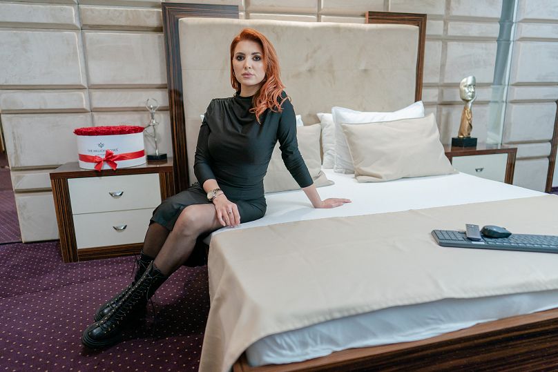
Cam Girl in Video Chat Studio, January 2023/Andrei Pungovschi, AFP
The platform that has provided Tate with his bread and butter are a stream of willing girls, entrepreneurs of their own, perhaps, who help provide a basis for his platform to flourish in an unregulated way that would not be so available in Ft. Lauderdale or even Miami. The platform pushes the limits of “Free Speech” but offers Tate a rich online persona that he has been able to cultivate and perpetuate online, indeed boosting his position even in a country where sexually explicit activity is a teeny share–but 5%–of the range of work women are able to earn when keeping their clothes on: the visages of the chat girl have offered a way to boost Tate’s reputation for his uniquely misogynist brand that has gained broad credibility online, providing a rich resource to which algorithms are able to steer his economic base of male clients of “Hustlers.”
But no one had exploited the internet like Tate from Romania, or gained the global following that won wide support on right-wing social media after he had thrown support bend Trump during the US election campaign. The fame that Tate one as an influencer had made him that strangest of animals of the internet, a hero of CPAC boys whose alienated isolated users saw him as giving voice to a resentment in his misogynistic rhetoric too over-the-top to be voiced by a right wing Republican Party, but whose followers were able to be brought into the fold of the Trump tent, and become a constitutive support for the team, fed by a close friendship with Donald Trump, Jr., whose condemnation of Tate’s detention as the “insanity” of politics echoed his father’s condemnation of a “witch hunt” paralleled his discussions with Tucker Carlson in 2023, endorsement by Elon Musk as a future candidate for the British politics, and support form J.D. Vance–a follower of both Tates on X–on pro-Tate podcasts. Tate has long condemned the compliance of conformity to DEI as a loss of soul and spirit; shortly after Trump’s electoral victory, Tate was poised for transactional gain, hinging at the coming dismissal of all charges against him. He had long been a social media imitator of Trump in attacking the politically motivated “witch hunt” against him, plotted by USAID programs weaponized against targets who were not woke, and verged from an influencer to a priest against the degeneracy that threatened straight, white males in a society where “if you’re a weak man . . . and you don’t have the strength and resilience to resist the trials and tribulations of being a man, and you’re constantly hurt by everything,” depression and isolation is a norm that needs to find refuge in the ethos of masculinity that Tate embodies but the radical left has marginalized.
The margins of the law–and of protection of individual women against predators–were pushed as Tate was offered entrance into the United States, before the admission was reversed on the technical suspension of Romania from the Visa Waiver Program granting admission without a visa for ninety days. But Tate had already become a poster boy for the very sexual predator that Trump has increasingly championed, and allowed to evade the law, whose hypermasculinity seems tied to his prominence on the manosphere, more than any credible rights of free speech. The Tates returned to the trappings of their international prominence–their multimillion-dollar supercar – no longer leaking oil on the streets of Bucharest, ostensibly to meet legal obligations to face trial without having to remain under house arrest, as the annulment of Romanian elections that were discredited after the revelation of Russian interference online campaign for the far-right candidate won–even. if J.D. Vance, fresh off experience with bankrolling right-wing candidates in allegedly open elections, crowed, “If your democracy can be destroyed with a few hundred thousand dollars of digital advertising from a foreign country, then it wasn’t very strong to begin with.”
Tate’s uncanny ability to monetize his omnipresence in the media manosphere may seem an eery reflection of that of Donald Trump, he has become a puppet of the alt right and Right Wing CPAC crew–Tucker Carlson; Elon Musk; Donald Trump, Jr.; Paul Ingrassia–that may well mirror the brew of False Populism espoused by each and the attack on the autonomy of a judicial system, or society of laws, that led UltraViolet Action to demand that Trump’s Attorney General, Florida native Pam Bondi, to extradite Andrew Tate to the United Kingdom from the Miami Beach mansion he rented to face charges against him, compiling testimonies of survivors of Tate’s violent abuse as a rapist able to exploit violence against women, as much as a poster child for free speech who was framed.


Despite Trump’s rhetoric of seeking to “protect women” in maintaining a clear division of sex roles, Donald Trump, Jr., J.D. Vance, and Tucker Carlson promoted Tate on social media, and appeared on pro-Tate podcasts that made social media circuits, during the election, leading Don, Jr. to attack Tate’s confinement as “absolutely insanity” and a politically motivated “witch hunt” from September 2023, aping Trump’s oft-repeated defense of his ties to Russia in the 2016 Presidential Campaign. Even as the Romanian court seized $3.9 million in cash and goods–fifteen luxury cars, fourteen designer watches, and cash in multiple currencies–he long insisted “there’s not a single video of an abused girl or one single statement against us,” promoting himself “one of the most important people on the planet,” the charges and accusations from multiple ex-girlfriends of sexual violence, coercion, and battery aside. Tate has remained a poster-child for absence of guilt, distracting from his unhesitating peddling pornography for self-enrichment on a global scale, with ties to trafficking, reveling outside of social norms or sanctioned codes of conduct in a social contract–his cultivation of misogynistic hate-speech in online forums have provided balm to the socially isolated men of the twenty-first century, the influencer in a hoodie who is professionally angry and aggrieved. This is increasingly a “real world” that young men increasingly live, and Tate sees himself as a totem of the aggrieved victim who is nonethlesss successful at making it.
But he is particularly distrusting as an emblem of a false populism, cultivated in the currency of the online where he continues to emerge unscathed from legal charges. The changes aside, the Tates seem free to cross borders, as denizens of a shady internet. If the two Tates possess three citizenship, British, American, and as naturalized Romanians, Andrew Tate was a global creation and seems a global trendsetter–storing profits from business ventures offshore in Dubai, an in Bitcoin, and other cryptocurrencies, given far fewer financial regulations in Romania than in the UK or United States, and to invest in a large portfolio of Central European real estate, vastly boosting his net worth, and evade regulatory oversight. The features made him the product of the slippery frictionless world of the internet, able to appeal to lonely disgruntled men across boundaries who turn to social media in an attempt to get ahead, and seek affirmation in worlds that are removed from actual human interaction, are overwhelmingly attracted to the targeting of women as at fault for their own sense grievances at an imagined loss of status, eager to turn to the internet into the platform of new identity as Andrew Tate so proudly has, flaunting his own sense of fame before cameras proudly, in violation of all social norms, an incarnation of pure testosterone.
Was his decampment to Florida a way to gain ready access to the “offshore” Caribbean countries whose passports he also held? They are also the new entrepreneurs, not real people, per se, but icons of hatred and resentment, promising new worlds outside the social reality of the many, an exclusive utopia of hatred and free from gatekeepers, where the non-person who cultivates online followings may promise an escape demanding little attention or reflection, but a reflexive thinking and action alternate worlds, existing entirely online, and far removed from he world of education.
Is Tate’s career something of a reflection of the scissors of an educated public, in which men have increasingly removed themselves from critical thought or education, rather terrifyingly dropping in their attainment of college degrees? The hunting comfort with which the Tates perpetrate attacks on women and champion toxic masculinity cater to the AI algorithms of the internet that offer a self-righteous claims that demand attention, attracting male audiences from the growing margins of wealth inequality and a society that cannot care for itself where more fall through the cracks, offering the worst convictions of unremitting passionate intensity among the lonely online, appearing as an answer to the bankrupt nature of an academic world dominated by women.
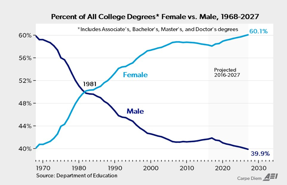
Declining Numbers of Men Attaining College Degrees in United States, 1970-2016/Dept. of Education
Indeed, the Tates have ably navigated the slippery sovereignty of a globalized world, evading any jurisdictions that set up laws that potentially restricted his trade. Tate modeled the personal freedom of holders of multiple passports–“passport bros”–among those disillusioned with the limited prospects in domestic market, to court economic investment opportunities or relationships outside legal oversight, cultivating “global citizenship” by purchasing citizenship in such offshore sites as St Kitts and Nevis ($250,000), St. Lucia ($100,000), or Antigua and Barbuda ($100,000), all for sale to attract real estate investment–and is a model for a future notion of post-citizenship, freed from national legal or economic regimes by a program of “Citizenship by Investment.”

Andrew and Tristan Tate on Release from Bucharest Jail on January 9, 2025/Vadim Girda, AP
The release of the Tates from house arrest in Bucharest arrived as they faced charges with the support of their followers. But the support of Don Trump, Jr., Alex Jones, and Elon Musk had improbably made them darlings of the alt right, even at the recent CPAC meeting. The celebrity of these notorious internet “gurus” or celebrity influencers extended beyond frequent media posts featuring sexist slurs and misogynist homophobic slurs to demean Trump’s political opponent–or the supporters of Kamala Harris, as if her political career was due to sexual favors.
These slurs were broadcast to his over fourteen million online (most likely entirely male) followers that had given him prominence in the MAGA universe. By promising to promote techniques of self-discipline, confidence and motivation common to talented and powerful men. Hustler’s University is a modern Machiavellian ticket to power, in a world where most all feel disenfranchised, promoting professionalism rather than credentials and confidence of self-determination in place of the slippery alternative of self-examination–promising confronting issues of “personal responsibility and accountability,” that promises as its very own “PhD”–the “Pimpin’ Hoes Degree” reflecting skills of grooming women for sexual work. The unfunny equation of wealth with skills of isolating and manipulatively persuading women to perform sex acts before webcams–transforming people into puppets–constituted the highest life skills the Tates promised at Hustler’s University. And if an investigation in Florida has begun into the Tates, who “publicly admitted to participating in what very much appears to be soliciting, trafficking, preying upon women around the world,” the question of whether they will continue to evade legal prosecution may be on the front burner of local and world news.
Tate’s debasing of education (even online education) in this alternative reality degree melds worlds of porno, bitcoin, and a smooth global surface of financial transactions that easily intersected with one of emotional neediness. It promised to smooth out your future by the psychological warfare tactics of ‘gradual steps to remove her entire support structure from her life” to create one for yourself. Proclaiming himself “one of the most dangerous men on this planet” in his own cultivated online persona, in eerily Elon Muskian ways, the Tates’ recent move to Florida may have been boosted by the lack of regulation in the state its governor, Ron de Santis, celebrated as a “freedom state” in the pandemic, but was easier something of a hub for alt right influencers who took up the Tates’ perverse cause. (Musk himself had long urged the Romanian government to drop the legal charges Tate faced.). Is it a surprise to hear Musk vouch to Joe Rogan that A.I. technology will bring “sex robots” to the market in “less than five years,” sex puppets if far more “realistic” than an inflatable dolls, allowing customers to “have whatever you want” from “a furry lady”to an alien Aurora out of the movie Avatar? The Avatar sex doll with blue skin on the market in 2025 is promoted as the “most realistic love doll” money can buy, with the “furry sex doll” made of “superior silicone and TPE materials” promising to “satisfy your fantasy” in harmony with nature. (These sex dolls, beside anime sex dolls of rather grotesque features, make up a market in alien sex dolls, a crude skimming of the internet reveals, are a rather rich niche market, featuring “unique non-human physical features, from green or red skin, large eyes, antennae and tails; the Pandora doll promising to be in harmony with nature features stylized beautiful blue skin, golden eyes, and pointed ears, with a truly “authentic feel” that boggles the mind about standards of authenticity as much as new horizons of pleasure–and simulated rape?–that Artificial Intelligence is promising.)
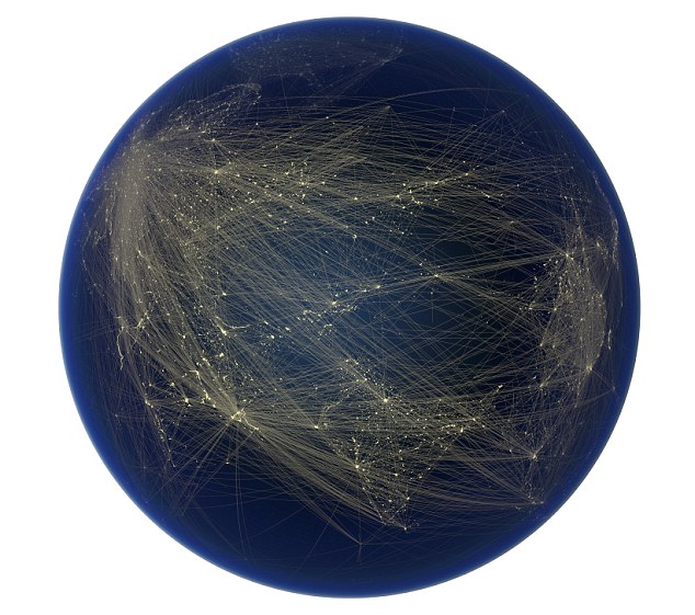
Andrew Tate promised his followers unfettered entry to a global community with access to tapping abundant wealth, a sort of Land of Cockaigne of untold abundance via sex videos flourishing on a virtual platform, promising a long-dreamed pathway to upward social mobility. Promising a way to beat the system, it is the ultimate red-pill entry to a “Real World” where “you’re part of an elite circle, receiving first-class training directly from seasoned millionaires,” allowing you to “elevate your game to levels you never imagined,” for those without much imagination of how to better their lives. You can be part of a globe-trotting world of men wearing sunglasses on airplanes, no longer “chained to mediocrity, laziness, and arrogance” that will take you to “true prosperity” in a pathway that has weird echoes of personal enlightenment and a financial scam, so blatant that it doesn’t might calling itself Hustlers University, that teaches you how to be a hustler on a global chessboard only superficially opaque, without any actual location, but converts the continents into a smooth gold surface of a gold-paved world that promises a generation of income through sexual subjection. If the Rook was a token of a global chessboard, the globe, for all its vaguely illuminated ghost-like grid, was a gateway to prosperity, or toolset for deception that would allow you to get ahead as they navigated the gold-plated manosphere that lay present in any map, so long as you could detect it.

The Real World AI by Andrew Tate Official ©️
The world glimmers beneath a rook that conveys domination, as if one merely need to learn rules of a game long concealed from you, but provides you with a sense of a deep game outside the deep state in exchange for a rapid payment of $8,000 that is a cheap ticket to life-long prosperity. The all-male club rests on the subjection of women to demanding tasks, often including physical violence, rooted in communicating a sense of total control over the vulnerable for personal gain. While rooted in cult-like brainwashing, the chatroom that incubates this access to a new world of wealth by the “life-changing positive force” of social media influencer Andrew Tate, a self-identified misogynist who rose to fame on the television show Big Brother in 2016 he had sought to model his violent lifestyle to 7.6 million Twitter followers–he now boasts 10 million on X–and recalls Don DeLillo’s prophecy that the future in crowds as much as Donald Trump himself.
The globe that Tate uses to describe his “university” is an eery reflection of global sex-trafficking, but it only highlights the money to be made in all places for the Knight–a horse-like figure that is arbitrary, and not clearly assigned a gender or sex, and defined by its motion on the chessboard more than gender, but which the Tates imagine a figure of martial conquest and an emblem of they role in the world. Tate has emerged from the world of kickboxing to cultivate an image and role as a global citizen, not confined by nationality, and espousing his creed and credo online–the very medium for his game. He boasts he is not subject to jurisdiction or national laws. In quite eery similarity to President Trump, Tate has openly boasted “I’m living in a society where my money, my influence, and my power mean that I’m not below or beholden” to the law–if women, he famously argued, should “bear responsibility” for sexual assault. His reality television gig on “Big Brother” in 2016 led to cultivation on social media of an alluring online presence, whose hateful charges that women who are raped are not victim, but should be considered responsible for the attacks, gained broad appeal. The “king of toxic masculinity” doesn’t really live in any society or legal regime–he claims nineteen passports, as if this gives him full legal immunity and extraterritoriality, as he has built his empire entirely online. What he most enjoyed, however, was “living in countries where corruption is accessible to everybody,” and where everybody is able to bribe their way out of petty offenses as speeding tickets–and probably set his eyes on escaping warrants issued against him in England, finding Romania highly ranking on Transparency International’s Corruption Perceptions Index, if not much more than the global average, and Europe’s primary source for sex trafficking.
Tate established the country of Romania as his base from 2016, cunningly selecting a known hub of human trafficking; Bucharest proved a site to locate fantasy portal of male domination able to be broadcast globally with relative impunity, and was in the EU. But with historically chronically low levels of oversight, Romania was a hotspot of trafficking from the start of the millennia between Eastern Europe, and the center for a new level of human trafficking in vulnerable refugees, the greatest site of women trafficked to Europe for sexual exploitation–
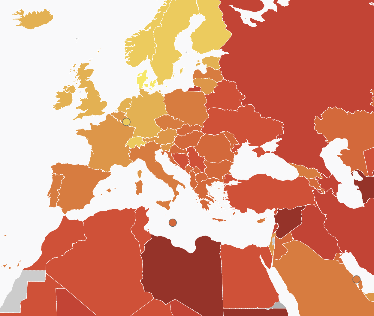
Corruption Perceptions Index, 2024/Transparency International
Increased human trafficking globally was a trade involving 140,000 persons a year, generating an astronomical $3bn annually, estimates UNODC, whose hub in Romania was well-established by 2010, many of whom were recruited to be sent by gangs to the UK against their will–at the forefront of pan-European statistics in recent years–

Romania has remained a primary “source country” for sex trafficking and labor trafficking victims in Europe, attracting the Tates to the country where they felt beyond the reach of the law by 2024, and a center for organized crime groups tied to human trafficking–whose victims, from forced begging, sexual exploitation, and labor exploitation, can be traced across Europe, and, despite the difficulties of counting or tabulating what is still tragically a largely hidden phenomena.

Geographic Range of Individual Victims of Trafficking from Romania/2024
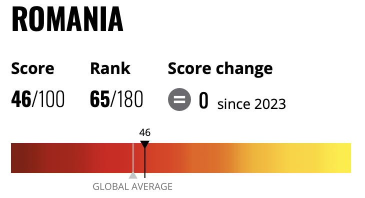
–many girls who were tragically recruited, as public signage in Romania warns, by acquaintances–the poster in a Bucharest public transit station features a lipsticked girl denying she might ever be a victim (“Me? It cannot happen to me!”)–to raise public awareness about trafficking dangers–
–and several organizations have increasingly tried to raise consciousness about and help the victims of sex-trafficking, in ways that provide a needed context for the case against the Tate Bros–and feature the haunted look at the victims of sex trafficking mostly recruited by seeming friends.
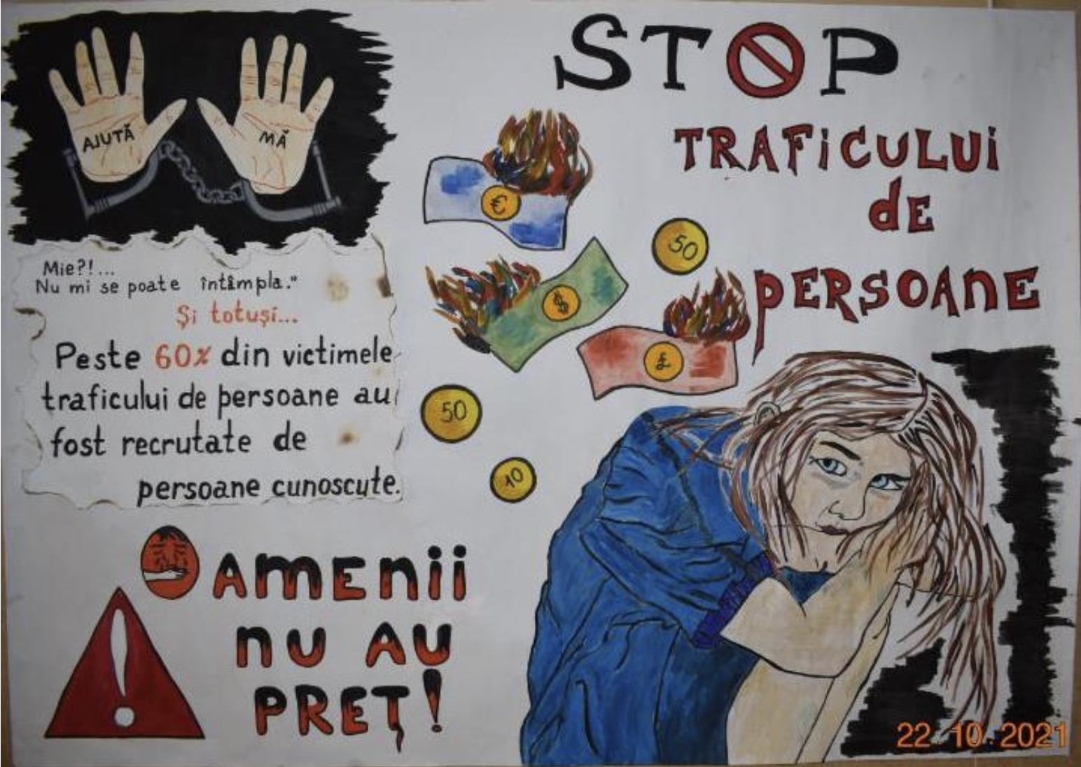
Stop Human Tafficking!–Over 60% of Victims of Traffickers are Recruited by Personal Acquaintances/2021
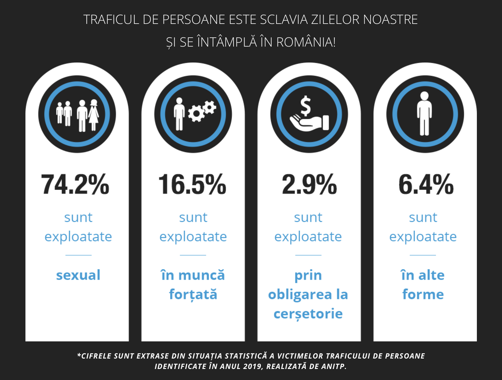
Even if buying and selling sex is illegal. As single women and girls flee Ukraine, 6,000,000 refugees crossing to Romania since 2002, vulnerability to sexual trafficking increased by the thousands in Romania: about three quarters of Romanian girls 14-19, per World Vision, describe human trafficking as including prostitution (72%); a third forced labor (34%); a third forced begging (30%).
Was Tate a war profiteer? He certainly profited from and preyed on erasing women’s experience in a site where there were increasingly vulnerable refugees, extremely vulnerable to be controlled and without many defenses; he championed his ability to strip them of defenses. But since the expansion of sexual trafficking in Romania from the start of the millennium, the state government has tried to control trafficking to change its recent reputation for lawlessness–despite the high vulnerability of displaced women to human trafficking, increasing punishment for human traffickers since joining the European Union in 2007 in ways that would lead the state to charge Tate with arrest. And Tate was apprehended by a dedicated anti-trafficking unit create to prosecute trafficking crimes and provide training and support to prosecutors, gaining a financial investigations unite from 2023 that helped expand the number of sex trafficking cases they might investigate by mapping financial transactions, in ways that helped locate Tate within their sights.
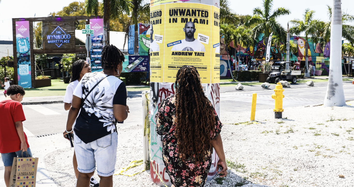
The power of such “influencers” as Andrew and Tristan Tate dramatically escalated for the Alt Right media as Tate’s “imprisonment in Romania” became a rallying cry of Free Speech. Members of his cultish tribe of G’s vowed in open proclamations of fealty to “prepare for the time when our commander comes back” in ways that aped rich-wing militia like the Proud Boys, using the micro-culture of the online community to promote not only a self-help group that had the appearances of a get-rich-quick scheme as if it were an underground of warriors, whose “soldiers need to strengthen one another for the time when our commander comes back” after his time in a Central European prison on what seemed dubious charges, but were in fact the same charges he had faced in the UK. Dedicated converts glorified Tate as a martyr of global tyranny, swearing “we are all grateful for the ability you are giving us” to prove ourselves by “risking your life to fight the good fight against tyranny” by extolling his work in helping them see through the false scrim that was the “Matrix,” providing a Real World in Hustlers’ University that clarified the danger posed by “all the puppets involved” in it. His arrest in Bucharest on December 30, 2022 led to a brisk online trade of t-shirts and swag using what seemed his mug shot tp promote the cause of a man charged with rape, human trafficking, and forming an organized criminal group were a political prisoner–

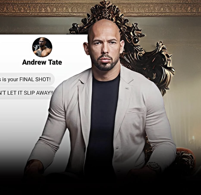
For his many devoted online followers, Tate was accepted a savior who alone could help them to navigate though dark times of loneliness, rent payments, and medical bills, where they must have had problems in distinguishing the real world form that of psychosis for those who “live paycheck to paycheck” in hopes of help in increasingly urgent desperate tenor, vexing to read because they seem almost verging on a psychotic break. “Free Tate” became a collective cry, while Tate was imprisoned in Romania, where he had fled to avoid the law; he was safe, but the location he was held must have conjured a Central European prison, and transformed Tate into a victim of plutocracy, awaiting for his champion in Donald J. Trump. By September, 2024, Tate went so far as to offer free membership in his online community, boosting his online persona to raise funds for legal defense–#andrewtatelifstyle#wealth#andrewtatemotivation#motivationmafia#talismantate–to all as a FIAL SHOT–as if he were a political prisoner able to model a wealthy lifestyle.
Describing in his life biography being raised by a single mother in Luton, England, living only on the frozen leftovers of uneaten KFC take-out that they froze for future meals, he rose to fame in the world of kickboxing to model the ultra-luxury lifestyle that features a fleet of thirty-three cars whose emissions he has boasted to Greta Thunberg release “enormous emissions.” Tate’s unprecedented frankness goes beyond Free Speech, but opens a door to clarification of power dynamics that He opens an alternative world of reality, or an alternate reality, appealing to young men, where “when you’re a realist, you’re sexist,” and there is actually “no way you can be rooted in reality and not her sexist.” While claiming with fervor he is a “force for good . . . actually acting under the instruction of God to do good things,” banned from YouTube, Facebook, TikTok and Instagram, platforms on which he once flourished as X as “cobratate.”
The sole platform on which the Tates have survived was X. The Tates’ bread-and-butter currency was owned by Elon Musk, a virtual protector in the manosphere modeling the “self-made millionaire.” Using nothing but a “little webcam business in my apartment” outside Bucharest, Tate profited from using seventy-five women in four geographically dispersed locations to rake in “$600,000 a month from webcam” in what he innocuously called the “adult entertainment industry.” (Musk’s latest start-up ensuring vitality almost seems a license for future sexual predation.). The discussion that emerged on Discord led many to dedicate themselves to his freedom, as Tate nurtured the sense of a deep, hidden war, he Discord where he thanked them for their dedication–“Thanks guys, we’re all going to make it.” He was worried about the possibility of his eclipse as a social media star to solicit their continued sympathy: “I remember yesterday thinking I will never be like those guys that get views” as he continued to post videos that circulated globally, promising to pierce though the veil of lies by teaching courses in crypto, e-commerce, and drop-shipping, as a pirate of the internet with the machismo of the high seas. And the arrival of the Tates in Florida–the region he had somehow negotiated the dropping of all charges and his arrival by a Gulfstream G550 private jet was widely celebrated by some as the release of a political prisoner.
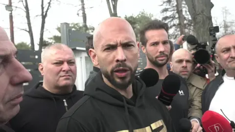
That the Tates landed in northern Florida while Prime Minister Sir Keir Starmer was visiting Trump in Washington was not on the radar of Starmer’s team, although Andrew Tate was fleeing charges he faced in the UK for money laundering, sex trafficking of underage minors, sex with minors, but felt like a triumph of the dark lower-feeders of the internet over the rule of international law. Tate was almost sounding victorious as he gloated, with deceptive half-truths, “We live in a democratic society where it’s innocent until proven guilty and I think my brother and I are largely misunderstood.” Long strong supporters of Trump’s candidacy for President, the online endorsements Tate provided, often using sexual slurs of deeply misogynistic nature, exploited how the “millions of men” following him on social media offered a snub of international law that had a special edge as Andrew insisted “we have yet to be convicted of any crime” and their lawyer told news his clients “feel secure in America for several reasons, the primary one being that Donald Trump is President”–as if their return was entirely contingent upon Trump’s electoral victory.

Andrew Tate after Arriving in Ft. Lauderdale/Vadim Ghirda/AP
The airplane landed in Ft. Lauderdale, but is it any surprise that one of the most notorious sites in America for sex offenders is in fact Orlando–a hub highly ranked among cities in America for sex offenders, next to Wilmington–a site whose numbers may be inflated due to the tax-free laws of a technically “offshore” site for credit cards. Neither Andrew or his brothers will be wearing electronic bracelets, as their charges have been dropped, unlike the many sex offenders who are sentenced to do so, some so indelibly described by Russell Banks’ Lost Memory of Skin (2011), a novel that invites readers to enter a community of unhoused sex offenders on the margins of residential Miami, finding shelter under a causeway near his house, that Banks read about in newspaper articles in the Miami New Times from 2007, describing the shanty town under the Julia Tuttle Causeway linksing Miami to the shore, a causeway that offered shelter in a world saturated with internet pornography, which the lost memory of skin haunts despite the psychic toll of residents: the inhabitants of an encampment populated by sex offenders was cleared by 2010, but the over two hundred and sixty sex-offenders clustered in some fifty tents who listed their only residence as the intersection of Hialeah and Miami, among squat warehouses, were bound by electric bracelets restricting their movement and beeped when they went out of range between 10 p.m. and 6 a.m. Banks mapped the community as a distortion of space, located in empty non-spaces in his 2011 novel, an intersection of the market and legal surveillance lying “in the misty zone between reality and imagery, no longer able to tell the difference,” a negative space created by the internet as an absence of embodied intimacy. The book’s twenty year old male antihero solicited a minor online as he felt “real” only when downloading porn–“watching pornography and masturbating were the only times he felt real,” Banks writes, when he was not moving as a “dust bunny shaped like a person” or a soulless puppet of accumulated dead skin.
The refuge in the encampment beneath a causeway that Banks entered by chance encounter with the article explored the placelessness of online screens, a negative space of refuge from electronic tracking of sex offenders, doubly marginalized as they live in a part of the city without emergency preparation or emergency response. The state of Florida has indeed long occupied the nation as a site of homelessness, it ranked sixth among states with large numbers of confirmed victims sex-trafficking, only behind Georgia, Mississippi, Arkansas, and Louisiana, and the number one ranked per residents, Nevada. No doubt the Tates will be welcome, if free from inclusion in registered lists of sex offenders police monitors maintain available online–

We are hardly immune, as a nation, from a global spread of human trafficking, if absent protection of victims keeps it off the front page of newspapers, and outside the public eye. Yet the growth of human trafficking in recent years has created clear hotspots in Nevada, strongly weighted by Las Vegas and Reno, and southern states of Georgia, Mississippi, Louisiana, and Arkansas, promised the very luxury lifetstyles that the Tates also knew was so crucial to the cultivation of their brand. In Florida, where the Tates arrived to well-wishers, the density of sex offenders is mapped by per 10,000 inhabitants, a rgzzly continuum for Tate takes his seat with less oversight, perhaps, than in Bucharest, if there seems to be little likelihood but that he is not about to start up his trade soon.
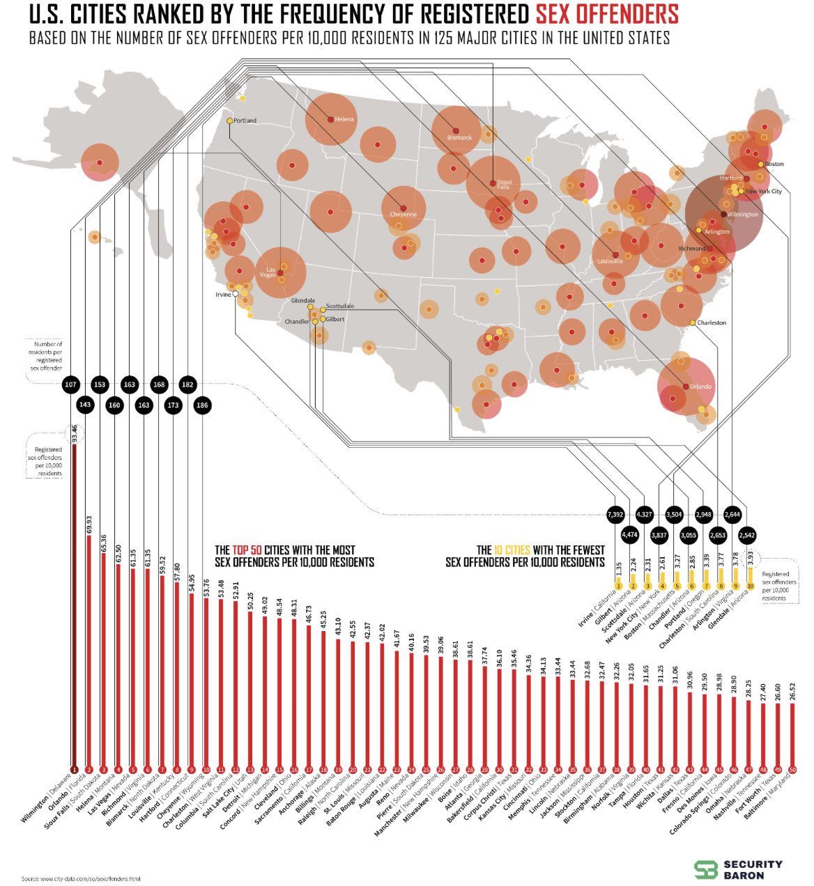
American Cities Ranked by Sex Offenders/Security.org
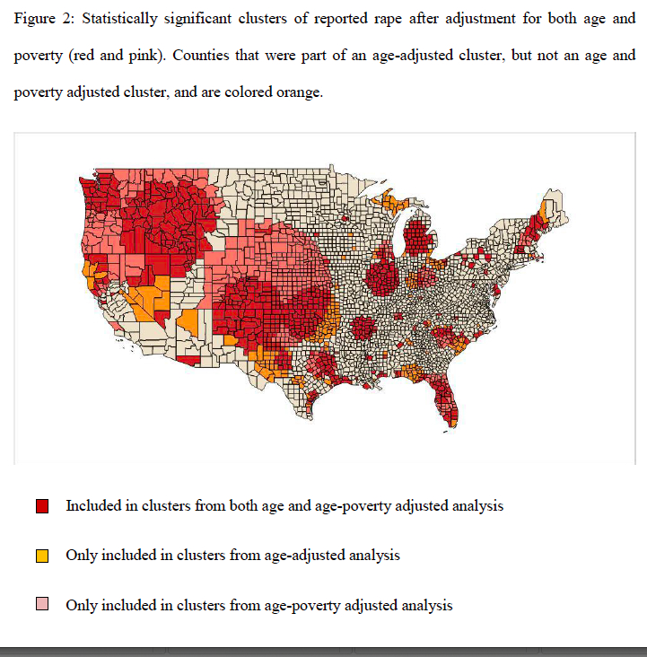
While Trump voters did not, perhaps, openly agree to welcome these sleazy smiling young men to fill the internet with male hegemony or misogyny, the new empire of the Tates in a state where there are more likelihood of a normalization of rape–based on adjustment for age and poverty–as Florida, as the second infographic map below shows or seems to reveal–mapping statistically significant geographic clusters of reports of rape in the United States from the years 2001-2011. The map hints at the possibility or alternate reality of normalizing rape as a community, as Florida alone among states approach the continuity and density of secessionist counties as Jefferson in northern California, a seat of the Alt Right, urban areas of Texas, or Reno and Las Vegas, Nevada-seedy sites, to be sure, but which in Florida seem a disquietingly dark shade of red–denoting clusters both age- and poverty-adusted, in ways that make their uniformity stand out in the lower forty eight.

Sexual Assault Cluster Map: Reported Rapes, 2001-2011/Studer Community Institute
This is the negative world not only on the margins of the law, or education, but not only of low-education counties, or low literacy but of low income, not only of low literacy–if there are some correspondences of note–but of deep inequalities. It is in some of these same spaces that the Tates are particularly successful at luring people with promises of wealth.
1. The offer to enter a world of untold wealth is promised and promoted, if you haven’t guessed, at Hustler’s University by the language of The Matrix. For it is in the real world, but at an angle to it, and provides a respite from the unfairness of society. For those ready and willing to take the red pill, to enter the reality of untold riches, as if a fantasy portal were ready by this seducer. It demands only recognition that you’ve been duped by a false map and a world of mediocrity that some folks are content to live. Are you ready to join? As if appropriating the language of a Calvinist elect, ready to offer illumination from a website of no real certification save that of bluster, as members of the church of the internet,–where you don’t even need a license to preach.
The pardon of King Trump awaits for the master hustler who is able to blame all of society’s issues on threats to the patriarchy in a world where most are being controlled and manipulated save those who take the “pill” of liberation by a portal of his own device, that borrows heavily from the film, operated by a bald man in Bucharest, recently retired from he world of kickboxing, itself based on staged illusion of Mixed Martial Arts, who appears with shades and a nicely groomed beard and sport shirts.

This is the mediated world in which Trump and his black-hatted buddy Musk dwell; it’s not unexpected that the head of Hustler’s University would gain the aid of Marco Rubio, who highlighted the injustice of jailing Andrew Tate, a military brat, in Bucharest, as the American was imprisoned under charges of rape and sex-trafficking in Romania for crimes that recent posturing of the American President suggested were in fact trumped up: but we might listen to Tate’s online boasting of the less than onerous nature of the trade in sexual domination and manipulation as a cushy job not demanding, but quite rewardingly remunerative as he converted his persuasive skills of domination and snake oil salesmanship through his webcam to reach a global paying audience.
This was not ever really about Free Speech as we know it, but about becoming the digerati who are able to make money on a new platform at an angle to the world, using only a cel phone to make money from drop shipping or e-commerce that required no actual labor, but entrepreneurship that smelled of a scam. Tate boasted in a notorious video aboutthe demands of the “job” he had fashioned for himself, that served as an example of his entrance to this world of untold wealth. “My job was to meet a girl, go on a few dates, sleep with her, test if she’s quality” and ensure she would be broken down psychologically to a point ‘where she’d do anything I say and then get her to go on webcam so we could get rich together” streaming porno to paying customers in the wider world–apparently the central conceit and get-rich-quick strategy of “wealth creation” promised by Hustler’s University, with its disturbing channeling of free-speech advocate Larry Flynt.
After facing jail terms for tax evasion for online businesses in the UK in late 2024, Tate had fled England to escape the threats of British courts to seize $2.4 million from his bank accounts. By then, Hustler’s University had morphed and expanded in the manner of online software, to new generations–Hustler’s University 2.0, then 3.0 before it was reborn as “The Real World,” as if in a bid to gain credibility as an alternate world without women, a virtual but deeply real version of a manosphere, offering men the ability to “escape slavery” for a mere £40 a month–which seemed a good deal.
The schemes began with sadistic exercises of psychological domination the Tates honed online but the tools of the trade were in fact hardly so new or particularly cutting edge at all, but a confidence game of sorts about staging empowerment before a live stream of paying customers: as if staging a puppet show of the internet, a drama denying subjectivity of sexual partners by gaining “consent” from women who were stripped of support structures or autonomy, while promising a respite from the “puppet show” of the other real life. The online version of a puppet show updated the oldest exercise of suspending belief, uncannily stripping subjectivity from the animated show of puppets that both entranced romantic figures as a theater of childhood and makes one, or made romantics as Goethe realize that they had to destroy the theater itself. This was not a theater to be destroyed, however, or grown out of, but available on one’s phone: the animated figures of female puppets of Tate’s theater of sex were trading in a currency of misogynistic domination doubling as get-rich strategies as well, the secrets of sexual domination presented as the ticket to wealth-generation by online schemes, only waiting for those who were ready to realize their visions of themselves as sexual dominators that they could use to win followers from the global audiences of online viewers.
Why is the United States government and the Trump administration paying such attention to release the restrictions that Tate faces in Bucharest? Does the social media influencer’s territory on X provide an answer? Human trafficking has long existed as a modern form of forced slavery based on a combination of coercion, deception and exploitation, an under-the-radar geographic mobility escaping attention, often, in modern times, coinciding with forced migration or refugee traffic, taking advantage of and preying vulnerable populations as streams of isolated women or children are seeking to move without defenses in unfamiliar circumstances and need.
But the internet makes this into an ever more monetized revenue scheme, animating often broken-down individual subjects for paying audiences of mostly paying men, expanding the routes of human trafficking and sex slavery on a new frictionless surface, moving often lower middle income persons on already existing patterns of exploitation by a slick visual medium on steroids–based on corruption and the lowered risk of criminal prosecution, and driven by economic need and necessity. Romania is a cutting edge country foe sex exploitation and trafficking as it is an edge or transit country, between two economic regimes with low legal oversight or protection, and lower income and higher income countries, encouraging rampant trafficking with impunity.

Institute for Trafficked and Exploited Persons/2020 World Bank Country Classifications
2. The territory is notional, but Trump and Musk are currently making it a national priority to block Romania from investigating the Tates for charges of money laundering, sex trafficking and rape. For Trump and Musk, he seems a sympathetic figure, wrongly jailed in a nation that is holding an American against wishes, even if he is not prevented from using his webcam in his apartment. When President Trump has his envoy bring up the case with Romania’s Prime Minister and government as if it were indeed a state issue, demanding Romania return the two brothers’ passports to them so that they might travel,–possibly to return to the United States, where he might be pardoned as the Proud Boys and Rod R. Blagojevich, aka Blago, to enter the legal marionette theater of Trump’s America, a true tauerspiel where the President acts as King and Puppet Master of a broad theater of unsavory characters with whom the Tates would presumably be right at home, welcomed into the manosphere that the United States was determined to become.
The thumbs-up Tate flashed as he had left house arrest that Tate delivered to the cameras as he was released from house arrest to await trial for human trafficking and rape on July 6, 2023, didn’t allow him or his brother Tristan to move from Bucharest, where they faced trial, but he insisted “We’ve been completely innocent since the beginning of this,” as if he were a victim of a political conspiracy, rather than an intimidator who was at the apex of a scheme of human trafficking conspiracy, rape, and sexual violence, his bother Tristan calmly assuring his waiting fans that “I’m always okay–I was okay in jail, I’m okay now” as supporters tribally cheered him on, chanting “Top-G1. Top-G!” as if to dignify him as the first among gentlemen, as the social media tribe prides thinking themselves.
Since then, Andrew and Tristan Tate have of course reemerged among the top demands of the new administration in Washington, as the envoys of Donal Trump work hard to secure his release, as if pandering to the fame that the Tates have won on social media as influencers, and particularly on X, as the eyes of the hurricane of a global manosphere.
But Trump’s envoy Richard Grenell saw fit to raise the fate of Tate in discussions with the Romanian Foreign Minister Emil Hurezeanu, who observed (until he thought it wiser to check himself) Grenell had pressed in his state visit he was “interested in the fate of the Tate brothers,” as if the issue of “the fate of the Tate brothers” were matters of national interest, and perhaps might provide a basis to rebuild diplomatic ties, before backpedalling to deny any appearance of legal impropriety, lest Bucharest appear a puppet state, confirming “no demands either during the Romanian Ministry of Foreign Affairs-Richard Grenell discussion or after it” during their talks: “Romanian courts are independent and operate based on the law,” rather than petty favors of quid pro quo–and only hold “the same values regarding the fundamental rights and freedoms of citizens” as America. Is that even a reassurance? The Prime Minister Marcel Ciolacu weighed in on X to clarify he never ever received “any requests to us upon the legal situation of well-known foreign influencers investigated by the Romanian authorities,” preserving a pretense of dignity and legal autonomy even if the whole thing was quickly degenerating into a global puppet theater, so that one almost lost sight that it–ans Tate’s wealth–was generated in part by global sex trade in the media frenzy.

Of course, those “fundamental rights and freedoms” are online speech, Trump has made clear early in his Presidency, and Is Trump being manipulated by Musk? The defense of Free Speech as a victory of the 2025 inauguration was nowhere more clearly evident than on the stage of the Inauguration, when an elated Elon Musk raised his fists in triumph, as Jeff Bezos smiled, and Sundar Pichai clapped somewhat sullenly, as Zuck looked on with his new bedfellows from a more marginal position than he’d have liked, and Trump’s visage was almost intentionally blurred.

Billionaire’s Row at 2025 Inauguration of Donald J. Trump
The protection of Free Speech on the internet, and the end of any filters on hate speech or fact-checks for a weird adoption of “community policing” seemed to open a new theater of fake news, hate speech and rumors, encouraging beliefs that the LA wildfires had indeed destroyed the homes of Ukrainian generals who had been enriched by American taxpayers, or USAID officers acting as fronts for corruption, even if Ukraine offered firefighters to combat the recent fires. The puppet theater is one of intolerance, in other words, and of protecting the rights of men like Tates who had millions of followers, proved good for the X platform, and attracted more users to their sites.
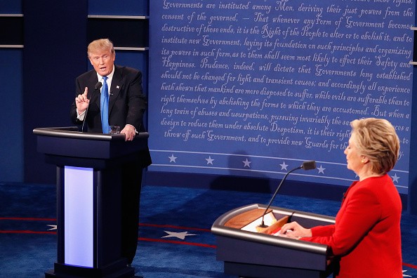
3. Or is Trump indeed not fascinated by the puppet? It is hard to forget the memorable accusations or counter-charges Hillary Clinton made in a Presidential Debate that merits rewatching today, as we try to understand where the United States is in global alliances. But it was the figure of female puppet–“No puppet! No puppet! . . . You’re the puppet! No!–You’re the puppet!”–with inarticulate bluster that became a comedic set-piece theater in the third Presidential debate with Hillary Clinton. What began as a debate on foreign policy, back in 2016, as Clinton charged that Putin “would rather have a puppet as president of the United States” shifted to borscht belt comedy on the status of puppets on a global stage that seemed a bit of a puppet show, after Clinton accused Trump of his willingness “to spout the Putin line” and “break up NATO, do whatever he wants you to do.”
Trump’s aggressive retort that seemed eerily to tap a deep-seated anger at being insulted onstage in such a manner was, of course, almost immediately eclipsed by the flood of internet memes it provoked—memes of puppets clamoring “No, you’re the puppet!” that, in an election turning on fears of America was rigged–had become rigged–and in which we were all, to some extent, puppets, left us wondering who was the puppeteer more than why Trump was so deeply wounded and ticked off. The exchange seemed evidence of “how childish our election system has become” as much as scowls of inarticulateness in contrast to Clinton’s poise. The theatrical staged exchange seemed evidence of the demeaning of politics of true virtues, or even interests, to a puppet show–

–or a “puppet madness” with its own seemingly vital online life in the post-debate world, as we looked to visual humor for some relief as Trump continued muttering, “No, you’re the puppet, . . . you’re the puppet” to gain some ground in ways that concealed how deeply wounded he was.

The puppet shows we now watch in our defense of two Anglo-Americans who made their fortunes teaching men the secrets of how to dominate and manipulate women as tools to escape the matrix, as if Fortune was a woman, and the platform they call Real World was “the portal to escape the matrix,” or the secret figures that, as a puppet theater, pull the strings and animate the individuals by controlling government and society, with only the freedom of online sex slavery the solution to make money, and unleash your inner millionaire, lest we continue to be distracted by those shadowy interests that “distract us for long enough so our bodies can be used for the machines”–as if it were a form of redemption. The unveiling of the “learning platform” that will dispense with all the necessary skills to become super-rich was long dismissed as another “get rich quick scheme,” with strong similarities, after all, to Trump University, although this is hardly the only superficial similarity between. the two men who have cast themselves as entrepreneurs.
4. Even if one shouldn’t say this, the demographic of one special sector the Trump voter may align more closely that we should ever admit. The stereotyping of the Trump voter should be resisted, as well as the attribution of the voter with a right-wing ideology. But the pool of pro-Trump voters overlap with the followers of the Tate brothers in disturbing ways, and indeed with the Tates –serial sex offenders who had gained fame as influencers on the manosphere district of the internet.
The release from jail of the two t-shirted Tates had fanboys who displayed their love for them in the manner many proclaimed devotion to Donal Trump at his rallies as Presidential candidate; as the ripped brothers emerged from holding cells in Bucharest, the Tates were swarmed by affection from fellow G’s who steadfastly and firmly supported Tristan and Andrew through their ordeal. The outsized support that the Trump administration took mirrors this outpouring of online sympathy at false accusation and imprisonment on house arrest. The support for the Tates in a country whose membership in the European Union is undecided given its widespread corruption has led to the restoration of their passports, confiscated financial assets, and dropping of criminal charges as they were provided with a private Gulfstream jet out of the country. Supporters of the Tates and long sought to protest and discredit the decision of courts in Bucharest, where the Tates fled to escape legal prosecution in England–seeking protection in the shadowy Central European country–the fear of a deal between the Romanian government and Trump White House seemed to reveal the preferential treatment to wealthy foreigners in a corrupt system, as Moscow was hoping to undermine the credibility of Romania’s elected government by trumping up its corruption. The release of the two Tates from house arrest in January, 2025, allowed them to continue to promote their brand of toxic masculinity online, possibly having bought their newfound liberty with unfrozen fortunes gained from their website, Hustlers’ University, their toxic online personas are poised to return to the internet as Romania faces more pressing problems of constitutional order.

The two bearded bros were in fact the very perpetrators of their own theater of cruelty of enticing women to acts of sexual submission. Yet, in the eyes of their defenders, it was they who at the end demanded their own freedom,–and what was the roll of the United States if not defend them? Who the constituencies were that attracted the Trump administration to the fate of the Tates was uncertain, but it might have begun in the Trump Dept. of justice, where lawyers who had defended the Tates was gainfully employed, and had fled to greener pastures, or maybe some of the fanboys of the Tates who had ties to the GOP, or even the folks at Turning Point, who had welcomed Trump’s election as “Daddy”–a term that Andrew Tate had reserved for his personalized T, “$Daddy.” Whatever the reason, if speculation is rife, the convicted Tates as they languished in jail in Romania quickly became a priority of the American government in place of America’s support for Ukraine, but championing the innocence of these poseurs is almost as much of a national embarrassment. Even if the Trump’s administration’s interference was criticized as a violation of their victims’ rights to due process, the muscular bros raised their fist seemed eager to cast themselves as vigilantes, warriors of the church on the internet far less violent than their online personas, even if they did seem hungry to return to the immersive world of online engagement.
Tates Leaving Criminal Court with Fist Raised in a Gesture of Defiance to Legal System
The fist-pump that Andrew Tate’s brother defiantly delivered as the two left Criminal Court in Bucharest telegraphed defiance in ways readily recognized online by the alt Right for whom Andrew became a prominent cause, even if he looked a bit more worn and peaked than he did on the muscleman portrait that broadcast his internet identity as $DADDY emblazoned defiantly on his shirt when he was taken into custody in August 2024. This moniker, and its sense of infantilization of the G[entlemen] of Real World, was a welcome submission to the power of the kickboxer who imposed his will on all women, holding himself up as a model for the male hegemony that would be their platform to a future better life. The Tates’ use of this rhetoric of conversion–a conversion expressed by the “red pill”–was an invitation to a real life of being without the false constraints imposed by society’s matrix, and the conspiracies that were preventing one from realizing wealth. Of course, Tate had only flow to Bucharest to escape the warrant that British officials had issue for his arrest, and the Romanian court granted the extradition request after the social media influencer would be tried, but that Tate was trying to escape the law for forming a criminal gang to sexually exploit women was of little import to his followers, who understood him as a martyr for their cause.
But there was also no doubt inescapable delight to the President in protecting the “rights” of the Tates as sex offenders for a President who describes himself elected as a sex offender, or to clear the charges that he was one–a first in American history. To be sure, Trump had a history of sexual misconduct, and the number of women who have charged him of sexual aggression has grown from two dozen women to forty so far. Trump has eagerly sought to deflect his conviction for sexual abuse in a civil trial as the outcome of a “legal circus”perhaps only a puppet show–puppet shows being parts of traveling circuses; Trump supporters accept his portrayal of the guilty verdict as “a continuation of the greatest witch hunt of all time”–despite the disservice to witches, and even the inquisitorial accusations of witchcraft that is meant to target the legitimacy of a modern court of justice or rule of law. The presiding judge had argued that the conviction of liability had amounted to a conviction of rape, but President Trump has resisted the accusation he compulsively denied, even seeking remuneration in the millions for being called “liable for rape,” nominating multiple accused serial sexual predators–Pete Hegseth; Matt Gaetz; Robert F. Kennedy, Jr.; Elon Musk–to be in his Cabinet. (Trump even energetically pursued several defamation suits against a network liable for a news anchor who identified him as “liable for rape,” questioning the semantics of statements he had “raped” a woman a jury deemed sexually abused as “false, mendacious, and designed to cause harm,” maybe still smarting from being called “the most mendacious President in American history”–if the presiding judge affirmed the charge of rape to be “substantially true.”).
The dismissal of charges for sexual trafficking fit Donald Trump’s increased inclination to open endorsements of hegemonic masculinity. Indeed, it seems to push the legal envelope in what was almost a personal vendetta, not only minimizing rape but condemning such accusations as malicious, if not “unlawful acts of election and voter interference.” The rejection of weakness and embrace of toughness seems central to Elon Musk, but was long cultivated in the torturous candidacy that led him to the White House, perhaps embraced as the key to victory over Kamala Harris, cobbling together a new Republican electorate by images of toughness and strength. While the Georgia jailhouse mugshot became one front on which Trump rallied against prosecutors with the charge “Never Surrender!,” the New York charges of sexual abuse was emblematic of a demand to prove his innocence, after the fact of legal judgment, casting the election as if a way to expunge the legal record in the court of public opinion, and reject the law. While social media influencer Andrew Tate was awaiting trial for accusations of human trafficking, rape, exploiting women, sex with a minor and money laundering, he contended he was being wrongly portrayed as a victim. Did Trump feel kinship with the man promising he hardly merited investigation by Romania’s anti-organized crime agency, DIICOT? The glamorously tattooed kickboxer complained that all evidence against him was trumped up, venting to the peoples’ court of the internet, as if he were on the cusp of innocence, despite a long history of cases of sexual aggression dating back over ten years.
But the absolute contempt for the law is very much on the surface of the stare conjures not the jaunty cover of the entrepreneur atop Trump Tower of The Art of the Deal, but an anguished pain that served, mutatis mutandi, as a model for the power pose of his 2025 Inaugural Scowl, a portrait that seems to be skirting legality and legal norms in time for a new Presidency. If a photograph is worth a thousand words, this mug shot was the photograph that changed Trump’s fortunes in the Presidential race, a fundraising opportunity of sorts that electrified his supporters and prepared them for the vigilante of Trump 2.0 as a man who was defiant, and confidently outside the law. While Trump was only visiting the jail–where he spent but twenty minutes before flying to his New Jersey golf club in a personal jet, his visit and mug shot offered an amazingly remunerative stage to repeat his claim that this prosecution was corrup–as the others he faced–and politically motivated.
He was resisting being a puppet of this corrupt legal regime, standing up for the freedoms of those who felt only anger, rage, and amazement at the inequities of th real world. The booking shot taken in Georgia serendipitously captured a sense of anger, resentment, and sense of grievance that may have thrown a life preserver to Donald Trump’s candidacy, generating after an outpouring of support that raise a record-breaking 4.18 million on the day it was taken, and raised $7.1 million since he was booked at an Atlanta jail. The single-day record for his entire campaign was a point of inflection, even more than the failed assassination in Pennsylvania when he dodged the bullet by jerking forward, the scowling mugshot reprinted on a range of merchandise–shirts, posters, bumper stickers and beverage coolers–with the telling tagline “NEVER SURRENDER!”
Is it any surprise that it became the template for is Inaugural Photo, breaking from tradition in using lighting from below and a grim scowl that glared at his public and the American people, a President who was fully prepared to show nothing but contempt for the law? The mugshot was posted on social media with the plea, as if felon to felon, to “make a contribution to evict Crooked Joe Biden from the White House . . . during this dark chapter in our nation’s history.”
Trump 2.0 was outside the law, maybe a puppet or maybe not, without any intention of complying with any court of law. He was content with the inevitable triumph in the court of public opinion, convinced of his place, even as the oldest President ever entering office, but in fact an outlaw President, fully confident of holding a secure place in the firmament of the manosphere. Trump realized that the resistance that the mugshot perfectly captured had an appeal and power over his followers that was the identity of Trump 2.0 as an outlaw President he was determined to embrace.
Daniel Torok
Was it a surprise that the first response to the image Trump posted of the 2025 portrait on Truth Social aped Tate, and led Charlie Kirk to crow “Dad is home” in response to the glowering portrait, as Byron Daniels, thanking Trump for the return of stability at the southern border, declared merely “Daddy’s back” and Lauren Bobert exulted on social media, “Daddy’s home!” The male figure of authority and discipline was adopted as a means of bringing discipline into the budget, even if many of the cuts of spending were alternatively exaggerated, obscene, and illusory, but talked a game of grandeur and a return of an actual figure of authoritarian power.
Trump is of course quite a master of delaying legal proceedings, blurring grounds of legal jurisdiction and appealing cases to defer the pronouncement of guilt. His bizarre exercise of visualization led him to imagine a grim fate and “very nasty life” had he lost the 2025 election–“it was dangerous, actually very dangerous“–as if the election might be understood in purely personal terms, even as he had framed it as a battle for “the fate of the country” in a nation divided between good and evil. Before guests from the Middle East, and Kingdom of Saudi Arabia, including its Princess, he suggested some introspection of surviving a deep personal crisis, public persecution, and vicious attacks more than assassin’s bullets, after riffing happily on economic progress of his future administration.–briefly entertaining the prison time he would have faced had not “all fifty states shifted in a Republican direction” as if this was a divine intervention delivering true justice, superseding any criminal trial. And a nod to the broad online community became part of a lineage of American entrepreneurship and innovation in the inaugural address, which praised the iPhone as condensing all knowledge to the palm of one’s hand: one wouldn’t ever need to leave the virtual world due to the triumphs of American skill
For tee election was a means of surpassing the travails of his worldly trial s in court. And his victory helped him win “great respect,”but demanded personal “courage” as if it were a trial to campaign on his own freedom, and overturn the judicial circus. As the ultimate confidence man, elected to terminate scams perpetuated on the American people, as he told the eager press gaggle, Trump seems drawn to the Tates, charlatans and online performers, as heroes of his own constituency, as much as purveyors of fraud strikingly akin to his own deceit, but also as purveyors of misogyny skilled at converting sexual abuses to personal fortunes. Most voters view sexual assault as disqualifying one from national office, but the embrace of the pleasure of demeaning women–often by sexual coercion–comes full bloom in the defense of the Tates within the performance of white masculinity. Rather than only a ‘brand,’ it is a dark ideology revering dominance, an extension of narcissism, that trumps the male hegemony reflected in cabinet picks.
6. Trump’s Presidency was never imagined to include champions of women. But as Trump embraces the Tates as props of hi sown theater of masculine, he acted to silence the accusers the Tates faced in the UK in an outrageous ways, and isolate them from legal accountability in their schemes of sex trafficking. Those championing themselves as the defenders of wrongly accused Americans held against their will in a foreign land, victims of a grievance, is an open perversion of the injustices that Trump seems eager to cast himself as able to rectify. The affirmation of the right of sexual harassment is far more explicit than in Trump 1.0, and is now a very unstable and risky propositions. The stubborn presence of four women alleging sexual abuse by Tate are distraught at Trump’s involvement in Romania’s court of justice. (Romania remained in the targets of Vice President J.D. Vance, who accuse the Constitutional Court as acting on “flimsy” evidence to charge Russians of any interference in Romania’s national elections, to undermine concerns the Constitutional Court expressed.) As a civil case against the Tates is pursued by English courts, many worry that Trump’s team is going out of their way to dismiss–“what’s a civil case?”–to allow the pair of brothers to escape, welcome them home to the fold to protect Tates. One of the brothers’ former lawyer has indeed found employment at the United States Justice Dept., praising Tate for “offering the dying West some hope for [historical] renewal” not a conman purveying evil.
Of course the women who are accusing the Tates must be trusted in recognizing a vile puppeteer–“Fie, fie, you counterfeit, you puppet you!” stammers Helena full of rage, in Midsummer Night’s Dream, Shakespeare’s drama about love, illusions, enchanted forest, and magical enchantment; amidst the tricks that hath such strong imagination, Hermia aims to turn the tables on her onetime friend by questioning the advantages by which she attracted her beloved by her stature: “she hath urged her height” to prevail “with her personage, her tall personage,/Her height forsooth” as but a counterfeit of love. Counterfeits of government and governing are central to all puppet shows.
Musk, for his part, has insisted that AI images of Musk as the puppeteer of Donald Trump that have become widely popular on the internet are mere malicious attempts to drive their bromance apart–“They’re trying to drive us apart!” But the disturbing visual of the President of the United States slumped at the Centennial Desk, his mouth closed, “like a puppet while his master does the talking,” raises questions. The man Trump named to run DOGE as a shadow-governmental organization explained to the nation what we voted for, and Trump didn’t smile, making much of the world wonder when they ever voted for Musk, and how much Trump is entranced at his dazzle and ready to consign all authority over state records into Musks’s ever-growing domain. The puppet show is here an unbalancing of the ship of state, a crisis of authority, yes, but even more gravely a sense of deep instability where the rule of law and all legal norms are up for grabs, with the promises of a paradigm shift lying in a theatrical exposing of the wrongs of government, while the Emperor wears no clothes, but because he is actually only made of the most malleable cloth.

Puppet theaters are, of course, what we have grown accustomed to expect from the Oval Office, where the props are on hand to turn the theater of state into a grand macabre, or a parody of state. Donald is there with his folly of renaming the Gulf of Mexico as the Gulf of America, as it’s only a map, and he’s a king, as if ready to stake claim to national waters that are far from his own territory, and expand the underseas seabed where the nation can stake claims for drilling oil, even pumping at underwater sites in Mexico’s national water, closer to Mexico’s shores.

The theater of domination is close to the theater of the nation, it seems, and maybe the real one that matters, before it is destroyed. Or will it ever be destroyed? For as our minds are being pummeled by the latest Punch & Judy show, with firings and dismissals proliferate in the name of streamlining and cost-cutting and undue excess, but the excess seems to be the point. And putting our national reputation on the line for the Tates, two truly despicable creatures not meriting defense who promise untold riches but have a habit of being so lax with their own databases to expose eight gigabytes of data of 968,447 user accounts to public scrutiny since 8 April 2024, suggesting they had little interest in the interests of their clients save their getting rich themselves.
 “Laos,”

 Open Street Map


 Mark Newman/2012 election cartograms

 Fall, 1968
 St. Sever (1030 AD, following Beatus Renanus)


 Donald J. Trump for President Ad, “
 Patrick Corrigan, Toronto Star (10/28/2009)
 Donald J. Trump for President Ad, “
 US-Canada Border Slash/Google Map Data © 2016–Creative Commons
 Carolyn Cuskey/Creative Commons
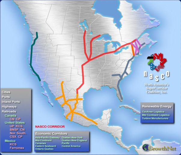

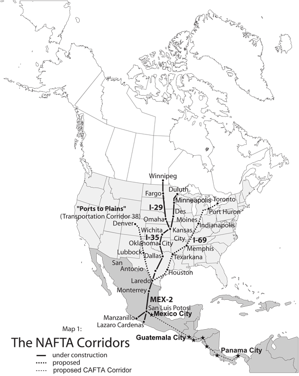
 June 2006 NASCO website image of I-35 Corridor

 Melanie Taub,


