Category Archives: Keyhole

Empire of All You Can Survey

In writing on Google Maps’ ambitions to map the world, Adam Fisher invokes Jorge Luis Borges‘ one-paragraph fable of how the Cartographers Guild “struck a Map of the Empire” at a 1:1 scale with its entirety, “On Exactitude in Science.”   Fisher evokes it in comparison to the massive collation of geographical coordinates in the virtual map Google Earth and Google’s project of remapping the world:  and although he does not note this, in Borges’ story, the map “which coincided point for point” with the empire is abandoned by generations “not so fond of the Study of Cartography as their Forebears.”

The map of the imperial cartographers Borges described stand as something of a reductio–or perhaps extensioad absurdam of the very sort of large-scale mapping that was first adopted in the English Ordnance Survey–a large-scale project of highly detailed national mapping begun in 1791 prototypically English in its character, ambition and scope.  What might be the largest (and longest lasting) mapping project ever undertaken might be worth some retrospective comparison.  The ambitious project of the Ordnance Survey of offering a highly detailed national map of six inches to the mile–since the 1950s, continuing at a scale of 1:10,000–set something of a standard for protecting the nation.  Originally aimed for one inch to 1000 yards (1:36,000), its framework was set by the Principal Triangulation of Great Britain (1783–1853), but its product served to record a legible record of all British lands.  The aim of the Ordnance Survey was to create a comprehensive record of Britain for ready consultation for defense against potential (French) invaders, and the instantiation of mapping of the nation has long been tied to military ends, whose tabulation of an exact correspondence to place provided an account of national resources and needs.  Borges’ evocation at the end of his tale of the continued presence of shreds of the paper map in remote deserts of the empire that he described is so very apposite because of how the comprehensive map-weaving in Google Earth renders any state-run project of paper mapping as so antiquated to be unrecognizable–and leaving any in shreds–although what the massive and glorious project reveals about map reading might be better explored.

The global map of Google assembles is of a qualitatively other order:   for one, it is an interactive exercise of letting the consumer decide what to map, or providing a selective map for their preferences or needs.  But more broadly, it is mapping for world-domination of the market for maps, which has no clear end-product.  And not only the market:  the interactive nature of Google Maps aims to make it inseparably fused to the minds of its users, suggests Michael Jones, chief technology officer at Google and co-founder of Keyhole, one of the first companies to offer online satellite views  suggests in a nice interview with James Fallows in the Atlantic.  For Jones, Google Maps  provide an “extra-smartness” due to their ready availability as interactive media,  effectively ramping up everyone’s IQ by 20 points and working toward offering a “continuous stream of guidance and information.”  Most users have so internalized the interactive map, the founder of Keyhole argues, that “they get so upset if the tools are inaccurate or let them down:  they feel like a fifth of their brain has been taken out.”  The aim is not to unfold Google Earth over a territory, but situate the map’s readability in our heads:  after 6,000-10,000 years, we’ve turned a bend and mapping has become both interactive and personal, or there is far less of a boundary between the personal and the map.

The map is no longer static, but both only and constantly being framed in an interactive fashion.  As well as change the nature of maps, it alters the nature of map readership in profoundly interesting ways, because of how it organizes and translates data into a new sort of platform.  Unlike a project of mapping national coherence, seems designed to offer a model for marketing maps that includes the ability to toggle directly into a visible record of place–“Street View”–that includes the now-familiar tagging of addresses, locations, and monuments that seemed once to be the semantic dominion of Facebook.  We can now see everything in the map, at incredibly high resolution, so we can prepare for trips of business, commerce, or pleasure by taking a look at the always-sunny record of the topography of wherever we might be heading when relying on Google’s Street View to take us there.

Whereas Borges described how the remnants of that hugely expansive paper map once coextensive with the empire that the cartographers created as lying only in the outlying deserts, Google hopes to overturn the notion of the paper map itself–leaving it shredded, or rather recycled–with everyone pulling up maps of their own on the screens of Android smart phones.  (Think of the cache of searched maps that one leaves, as a sort of paper trail, complete with search history and places navigated:  such information is not stored, Google says, but would give a veritable system of surveillance that the NSA must be eager to get its hands on, no matter what the recent ruling of Judge Richard J. Leon’s recent rebuke of mass surveillance practices, by questioning their violation of constitutional rights–no matter how ill-fated their attempt to mine big data to geo-locate global populations.  The “personalization” of the map as an interactive medium is widely seen as a surpassing of its static medium and becoming a web interface, introducing functions of zooming, panning, and rotating 360 degrees on a pin, qualitatively unlike a road atlas and even threatening to dethrone the TripTik.  For the “view” that Google aims to synthesize, linking the technologies of Keyhole and Google Earth and creates its illusion of continuity by how the alchemy of how digitized photography seamlessly melds images tagged with exact geographic coordinates.

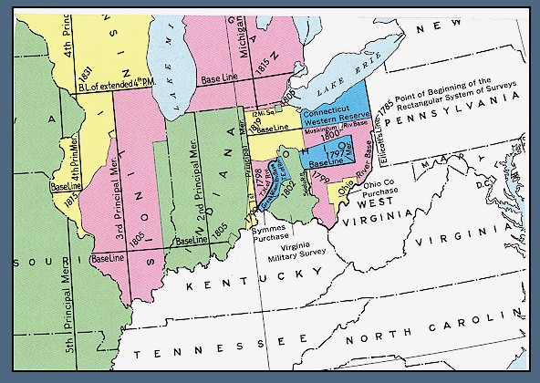
The excitement of translating global meridians as a scheme of reference are gone, as are the excitement of working from a single base-line, to be extended outwards by triangulation, that so distinguished the Principal Triangulation and its American emulator, the Point of Beginning–a starting point of the calculation of rectangular land-surveying that took on somewhat suitable evangelical tones for the New World, after the Royal Society tracked the Mason-Dixon line.  For the mapping of the territory of the US shaped the configuration of states from the ascertaining of the base-line that determined the rectangular surveying of the United States further West–


map_point_of_beginning


One thinks of a similar line not at the Continental Divide, but the line surveyed dividing the continents of Asia and Europe at a precise point in Russian lands–a point that was cause for continued debate from the time of Catherine the Great as to the European location of Russia’s capital cities, viewed from a train on the way from Yekaterinberg to Vladimir, one encounters a simple obelisk to note the division.


obelisk:  Europe is to the left!Derek Low


The stem division is inscribed along this frontier in monumental form at multiple sites, or in elegantly neorealist terms at another site, similarly in a wilderness, as if a monument that few would view until they arrived to see it or passed by:


p1030748


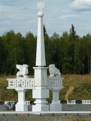
These material markers use statuary monumentality to remind passersby of the definitive nature of the line between continents that they traverse.

Google Maps (and Google Earth) is less concerned to create a correspondence within the conventions of maps to order space within a nation than to create a map outside sovereign bounds.  If there is a clear spatial marking of the “Point of Beginning” where the survey that determined state lines and lots drawn east of the Mississippi, the folks at Google have no interest to place a place where their mapping project begins; the premium is rather to capture all the points of view so accessible a mouse-click away.  There will be no reason or interest to mark an actual boundary line, was the case on the centenary of determining the boundary of 1786:   the marker celebrated the triumph of the conventions of the cartographical line in ways that Google won’t ever need to do, since their world mapping is entirely virtual, dispensing with or downplaying conventions like map-signs.


Beginning_Point_of_the_U.S._Public_Land_Survey_Ohio


When Google maps, there is no need for mere monuments–or the practice of verifying base-lines.  The empire of the visible that Google aims to construct is animated by the indexing of digital photographs that can be reassembled at the viewer’s will; Google will offer them upon demand.  The paradox is that little actual measurement is expected, but rather that lines of data flow must be secured:  programs can synthesize the photographs that are uploaded into Google’s Street View or Google Earth, and provide a way of moving from the street map to a representation of what it looks like to be outside the map–allowing one to toggle between “Map,” “Terrain,” and “Street-View”–the holy trinity of their App–to immerse oneself in the map wherever one is, without any need for future surveys, and in ways that show to all who care the skeletal nature of a simple map.  The map is dead, in the sense of a drawn map whose conventions are about translation, but long live the map as a visual record!

There is something like a back-end move in Street View, or Google Earth, as the photograph (or a million digital photographs, seamlessly woven together) substitutes for and comes to replace the map.  The symbolization of space in a street plan or road-map becomes a heuristic device for exploration, in ways that is only a hollow echo of the photographs synthesized in Street View, which are so much more satisfyingly real:  the innovation of the satellite views of Keyhole, acquired by Google and the basis for Google Earth, allows the direct proximity for viewing place, and exploring space, that seems to go through the other side of the map itself, or be a proxy mirror on what the map maps.  Google began its quest to assemble the world on the slippy screen by downloading–or purchasing–the newly declassified LandSat satellite photographs of the world’s surface, and by purchasing and synthesizing the U.S.G.S. surveys of our nation’s road maps:  little was newly mapped here, but the world was newly mapped, in the sense that it was now made available to a larger audience than it had ever been mapped for.  The empire of map-signs did not live long, however, because the unique marketing vehicle of Street View, which set Google Maps off from others, afforded viewers something more palpable and immediate (and more gratifying) than a mere map, and whose skeletal form is revealed by toggling among alternative views:  the map as the ultimate eye-candy and as the vehicle of voyeurism, where one wouldn’t have to be content with lines on a piece of paper, but could gloriously pan around and, yes, turn one’s attention to a perpetually sunny record of whatever one wanted to see.  (“Keyhole” technology all too appropriately allowed the very zooming into high-resolution satellite views of Earth that Google now provides, as if to engage the voyeuristic interest in reading maps that the static map did not allow, and has become central to the interactivity of Google Earth.)

Why would one chose to go back to the map, or explore the map as a medium in itself?  In a neat slight of hand, there suddenly is no map, in the sense that the map is trumped as the primary register of negotiating with place, and one can suddenly see through it.  The question then becomes less a map that is co-extensive with the world, but an image-mine that dispenses with the need to make any maps.  Sure, Google is going around and checking the relations of roads and one-way turns on their road maps.   The end of doing so is to create for its users a point of view that never needs to be redefined:  much as Denis Cosgrove argued the point of view of medieval maps was often understood as the eye of God, Google Maps provides a point of view somewhat like a Leibnizian eye of a God ever-present everywhere.   OpenStreetMap is often cast as a competitor to Google Maps, is pushing in the quite contrary direction not only in the open-ness of its A.P.I., but in preserving continued relevance for the map as a collective compilation of data and meaning–and preserving both the activity of transcription we all call mapping, but is always also mapping to help us better figure out our relation to how we occupy spatial expanse.  For as much as Google Earth might be seen as the modern corollary to “the Art of Cartography attained such Perfection that the map of a single Province occupied the entirety of a City” in Borges’ story, geo-caching Street View images in Google Earth suggests another parable.  Much as Yertle the Turtle, King of the Pond, proudly proclaimed himself Emperor of All He Could See, until Mack burped, Google feeds our inner Yertles, more than maps the spaces we occupy.

While the evocation of The Principal Triangulation of Great Britain may seem odd, the massive project of data collation set a standard that has long driven our notion of the land-map.  Google Maps creates a persuasive illusion of totality of the visible world that often does not map human networks or their environmental consequences, and which may leave us blind to them even as it champions map-reading as something like a spectator sport.  Google Earth’s dominance as a medium raises questions about what other sorts of networks are left unmapped, or what other methods of dynamic mapping might represent social networks, but that are less clearly revealed in its maps–or are obscured–in the seamlessly knit sunlit world that we track in the slippy maps of the open screens of our androids and other Google Earth browsers.

1 Comment

Filed under Google, Google Earth, Google Maps, Keyhole, OpenStreetMaps (OSM), Principal Triangulation of Great Britain

The Will to Map: GPS and its Discontents

Navigating the necklace of highways that hug the Santa Cruz Mountains beyond San Jose with a GPS map affixed to the windshield, you become both disoriented from the panorama before your eyes and quickly aware of the token roadmap GPS offers.  What is the map on the screen doing in the car and when do we need to look at its content?    The question emerges since it’s not clearly a partner to the voice-directions; the interface between isn’t evident or apparent:  the overlay of data on the terrain graphic of a Google Maps backdrop seems interactive, but shows a route, and not a guide or a means to explore paths of other possible travels.  There’s a need to offer a map in our map-saturated culture–but the map is no longer a clear way to translate familiarity with space to their readers, so much as an added document.

The difficulty of internalizing directions from the onscreen map derives from its limited use to orienting oneself, and is unlike the roadmaps that readers internalize over time.  It is not only ready-made and disposable, but seems to exist to satisfy customer expectations for a visual record more than offer users an actual guide.  It has limited relation to the injunctive directions declaimed by a Siri-like voice, and seems a source of ornament despite an absence of actual visual interest, as if it was designed to meet nostalgia for the visual records of automotive navigation on highways and interstates or for a time when we needed maps.  Some drivers might object to directions from a disembodied voice, instead of someone informed about the topography or terrain.

Without those over-creased highway maps in our glove compartment, one grapples with the minimalist Google Maps graphics before surrendering passively to the intoned directions, still frustrated that we can’t  transpose directions from the map, and conscious of being cognitively challenged, but perhaps pleased to contemplate a landscape of trees overhanging on each side of the mountain roads and to follow a course traced from on high.


Boulder Creek Map Traffic


The mechanics of the synthesis of a digitized map is of course completely different compilation of meaning.  But it is most striking that the map didn’t need to be there, and wasn’t that likely to be consulted as a navigational tool and of limited use if one strayed off course the curvy roads in the Santa Cruz mountains; if so, we’d be more likely to look at a paper map anyway, for the image provided little easily-consumed information of fine grain about the mountain roads; the verbal directions were so removed from the map as if to devalue the long history and use of maps as autonomous media: rather than provide the purification of spatial experience often attributed to maps, the schematic Mapquest image distances experience so abstracted from an actual route of travel to minimize our sense of reading space.

As well as a shift in how mapped information is synthesized, digitized maps mark a shift in reading terrestrial expanse and reading one’s place in maps, diminishing the relevance of a coordinate system or apprehension of spatial inter-relations.  Whereas the Mapquest route that defined a path of travel, navigation by GPS seems a new relation between map-use and environment.


images-1

The relation to its pixellated surface is rooted in fascination with the image that adjusts on one’s screen synchronized to one’s actual bearings, rather than reading one’s course and the options that it presents.  GPS was not made for wanderers.  The screen notes a route on a formal schema abstracted local terrain, which is replaced by a generic image, its data mediated at a remove from the world as if “flattened” to two dimensions, rather than the sort of surface that invited multiple possibilities.   The map produced on demand places cartography with limited sense of permanence; the personalized nature of the map it creates, as in a service economy, offers an image of terrestrial location that dazzles, but is only commensurate with a specific viewer’s specific needs, and as it is part of a system that provides on-demand maps that can be immediately generated for any global region.

Santa Cruz Mountains

The place of reading a GPS map in a car or a mobile phone is independent from the expectations for both providing and decoding the map.  How maps are read over time offers perspective on how maps address their readers by embodying a relation to space through their synthesis of spatial information.

Such an emphasis is distinct from, say, one on the mathematics by which cartographical projections synthesize data on a uniform graticule or techniques of transferring the curved surface of the world:  one can appreciate these precepts only in a very vague sort of way, similar to ignorance of how GPS generates a map, to read its organization.  As the video by which Google promotes Trekker as a natural extension of a user’s relation to their environment during a walk in the woods.  The mechanics by which the cameras stuffed into a bulky backpack remain both mystified and  outside of the average viewer’s appreciation or ken, but the user is amazed at how the digitized synthesis takes us through a mind-bogglingly detailed record of space.

One is awed by the alternative surrogate awesomeness that the map provides of the Grand Canyon.  The data such maps compile for readers implies a very different sort of map-reading from te far smaller-scale trail maps of a similar region which offers clues to travel on foot, rather than car, whose color-coded signs of elevation, trail lines, and symbols of orientation offer a semantic register to decode.

berryvreekfallsmap

The legibility of the above map engages different cognitive skills to decipher our position than the plastic formats of mapping in GPS, which derives from a  dramatically different context of the corporate investment in map making, less dependent on attracting viewers than provide comprehensive access.

Google Earth’s data collection and synthesis is unlike that of the National Geodetic Survey’s mandate to maintain “a consistent coordinate system that defines latitude, longitude, height, scale, gravity, and orientation throughout the United States” for the public, by which “everyone accurately knows where they are and where other things are anytime, anyplace.”  Criteria for mapping are now market-driven and based on providing information for consumers in an explosion of available maps.  Google acquired the digital mapping company Keyhole back in 2004, allegedly when Sergey Brin claims to have been so wowed by digitized maps of bombing Iraq he saw on television.  The digitized satellite maps that Keyhole provided afforded a new way of defining one’s relation to an over-mapped world:  Google’s vice-president, Jonathan Rosenberg, celebrated how the military-grade map-provider used by the Department of Defence was repositioned as it became “a valuable addition to Google’s efforts to organize the world’s information and make it universally accessible and useful,” allowing users to “fly like a superhero from your computer at home to a street corner somewhere in the world–or . . . map a road trip” by tapping information collected via satellite and airplanes through easy-to-use software.  The rhetoric was fulsome as the acquisition was completed: “The sun is shining brightly in Mountain View,” read the press release, describing Keyhole employees as “all smiles” and Google employees as “all open arms,” as the same software used by the US government to track the arrival of smart bombs to Iraq via a multi-terabyte database (and begun by a venture capital firm backed by the CIA) was re-deployed to dramatically expand the wide, wide world of GPS.

Driving through the region near Mountain View, one couldn’t help think of how the removed view on the GPS screen was a diminished share of the mapping tools Google had purchased.  It’s striking that even in 2004, Google felt the need to calm anxieties about the potentially intrusive nature of such satellite technology that would cover the United States, but was energized by the belief it could unseat Time-Warner’s Mapquest–as it has– in providing its users with a far more robust mapping technology to orient themselves.  “It’s not like you are going to be able to read a license plate on a car or see what an individual was doing when a particular image was taken” in ways that would violate their privacy,” Keyhole’s General Manager, John Hanke reassured the public.  The photographs, after all, were from a database generally six to twelve months old, rather than being real time.  But recent indications about intrusive surveillance suggests that such a project might not have been far from the CIA’s mind in funding the project, which Google rolled out as an innovation in both convenience and reach to craft high-tech maps for viewers from satellite views by its powerful search engine.

GPS  situated its customers into a culture already bombarded by images by granting vicarious participation in a Brave New World of digitized maps.  What is striking in the maps is the near-absence not only of textual but semantic content, which are dramatically reduced in its imagery to increase its ready legibility.  The ways maps were understood in specific sites of reading, argues the medievalist Patrick Gauthier Dalché, who examined the questions that readers from Italian humanists, monks, or the readers of marine charts had for maps, and called attention to the ways of reading maps as much as their semantic construction.

Considering the combinations and forms reading practices a printed map engaged opens interesting possibilities to understand relations of text and image in early printed maps whose readership is not known; it documents the cultural translation of mapped information from manuscript to print, and raises questions for the materials of reading we wax nostalgic when using GPS systems.  It is common to compare the shift in mapping space that digital  interfaces allow to the shift from manuscript and print in the European Renaissance, both as an increased legibility of space that maps diffused and the greater circulation of  maps as reproducible engravings.  We might take time to reconsider the different semantic varieties of map-reading print encouraged,  examining how early printed maps ask viewers to engage a representation of expanse to understand them as forms of spatial literacy.


Ptolemaeus Teutsch


Few land-masses are evident to modern viewers of this printed map of apparently spherical form, an early German translation of Ptolemaic precepts that transposes the form and outlines of a manuscript projection. Most likely adapting the semantic forms originating from a Ptolemaic codex its printer or engraver transposed the map onto the gridded surface of a globe to create the illusion of a mathematically derived spherical projection.  Although the spherical projection is but an illusion, the transposition of a Ptolemaic projection to a spherical grid provided a new way to read its place-names:  a few place-names on the surface of this printed map–“Europa,” “Asia,” “Ethiopia,” and a “Mare Indicum.”  Although the map echoed the tripartite organization of mappaemundi, numbers keyed locations to written descriptions unlike the ancient places listed in manuscripts of Ptolemy’s geographic manual:  the names were not only abstractions, but numbers provided tools to gloss a sophisticated primer of geographic knowledge, using Euclidean precepts to render global expanse on a uniform plane.  Readers would have seen the map and its accompanying German text–the map appeared as the fold-out endpaper of a book titled Ptolemaeus Teutsch–as mediating the ancient classical treatise of world-geography to a broader audience than a tradition of learned geography.

The map abstracted expanse as if to address readers familiar with single-line engraving by compacting of terrestrial relations–although it does not seem to have been as successful as a commodity as its printer hoped.  The limited success of the booklet may reflect the extent to which it dramatically and rather drastically condenses geographic data to symbolize measured expanse in a spherical format that imitated how globes prepared a surface for readers to  actively gloss, interpret, and reflect on its symbolization of expanse, and a dynamic tool to render and encode the distribution of worldly expanse.

Europa


The reduced size of the engraving encouraged its engraver to use numbers instead of bulky toponyms, in order to create an easily consultable spatial template for placing the known regions on a ruled plane surface which comprehended–and mimicked–the terrestrial globe.


Globe of Ptol Teutsche


If the GPS system made me think of the manner information was processed and distilled on the screen in a passive form of readership, the positioning of place on the globe suggested a combination of tools of single-line engraving and a facility to abstract a geometric record of spatial relations, often tied to a unique exchange between humanist and artists in Nuremberg’s visual culture that printers eagerly exploited to expand the book market.

The map recalls its rough contemporary, Martin Behaim’s Globe, celebrated for concretizing a “mental image” of a new relation to space and place in Nuremberg around 1490. Although it omits America,  the globe’s surface assembled an image of oceanic expanse that confirmed Behaim as master of crafting a modern relation to a  legible space from nautical charts circa 1492.


Behaim Vorstellung


This modern recreation of the Behaim globe’s underlying map suggests how the engraved spherical map reflects the status of globes as material records of regional relations, representing terrestrial curvature as much as to measure spatial relationships with precision or provide a guide for travel, and indeed to arrange the disposition of place on a globe.

The engraving reproduced skills of reading the commodity Behaim presented Maximilian I in 1492; it indicated appreciation of the material construction of the globe in imitating the epistemic claims and encyclopedic intent by combining visual and written on its surface, if in far compacted form.


Behaim's Globe


Behaim had earlier sailed with Portuguese vessels for several years, where he gained access to supposedly secret charts, and fashioned the globe from them, working with the painter, woodblock cutter, and printer Georg Glockendon to assimilate an abundant and expressive tradition of written geography even as they embodying expanse in a new form of material media. Earlier  publishers of colored maps for translations of Ptolemy’s ancient Geography unsuccessfully attempted to reach broad audiences; Behaim’s erdapfel provided a  materially impressive way to depict a comprehensive record of the inhabited world; if it exaggerated the world’s oceanic expanse, it  profited from empty oceans to inscribe written accounts of travelers from Marco Polo to Mandeville, in ways readily readable at a reader’s eye-level.

Behaim-Globus


The self-standing globe attempted to replace written geographic media it amply cited in as a materialization of global expanse, as much as completing empty spaces on the map’s surface:  it suggested empty spaces as a way to pique interest among its readers.  Unlike scholarly editions of Ptolemy, the material condensation of Behaim’s erdapfel was a powerful painted media, juxtaposing huge continents with islands that spill across its surface, making less reference to meridians or parallels than texts to orient its audience and invite them to pour over its content.

Globe's Written Surface


The globe echoes imperial regalia.  Designed for the Holy Roman Emperor Maximilian I, the modernity of the globe is thematized in a 1939 film about Behaim as a man of action, “Das unsterblich Herz,” portraying Behaim as a  precursor to Columbus, and a Germanic figure of modernity (rather than, say, Luther), whose will to map the world and African coast modernized the imperial heritage of Holy Roman Emperors:  no doubt his globe was imagined as something like a precursor to the Third Reich.  The cinematic retelling of how Behaim fashioned a globe of comprehensive coverage for Kaiser Maximilian I glorified the mapmaker’s imperial service.

The master of kraft, roughly contemporary to Columbus, is presented as conscious of the strategic deployment of maps as tools of dominance that broke with the medieval past:  this Behaim recognized the inaccuracy of sundials or timepieces at sea, and his decisive realization of the need for portable clocks enabled him to map the shore of western Africa, filling uncharted regions of the globe on account of his dedicated perseverance.  The film celebrated Behaim as a man of action and genius, representing the globe-maker’s craftwork and the material globe as an icon of modernity.  The Nuremberger’s skilled instrument making is indeed juxtaposed in the film with two other measures or standards of modernity, clocks and ammunition, which define a modern conception of time and finality that fundamentally broke from medieval conceptions of time and space; the globe-maker seems a figure who rises above medieval conceptions of the closure of the world’s confines, if not of the confines of an imperial expanse–if he also seems a bit manic in his vision than one might suppose of the historical Behaim.


Behaim--Unsterblich herz


The historical Behaim is far more complex, and so is his modernity.  Although the film lionizes a globe-maker who epitomized a way of being-in-the-world for its audience, Behaim worked from manuscript nautical charts to make his globe, and if he fashioned the globe was a modern way of interfacing with space by embodying it in concrete form, the globe provided a medium for reading space informed by multiple sources that its surface effectively synthesized.

Modern reconstructions of the globe and close-up photographs demonstrate how the globe creates a legible surface, a site of reading where place and space not primarily mediated  by meridians or parallels, as much as a grandiose modern conceptions.  Islands as those here around Taprobana suggest less of a unified than fragmentary regions for their reader to imagine, haphazardly situated on  the surface of the far-off the unknown shore of Asia, and as incomplete as closed.  Panels of text seem to anticipate the reading of a new notion of expanse, but treat the globe’s surface more as a composed text than a pictorial cartographical record.


Globe's Written Surface


The organization of meaning on the globe was no doubt in many ways understood as a site of writing, as well as a surface on which to trace extensive rivers, discovery lakes, or find move from the landscape to surrounding written texts.  Conceptually familiar sites like the rubicund Red Sea  provided reminders as much as depicting actual oceanic conditions–as is evident in this lovingly crafted modern facsimile of the globe in Alberta (Canada)–as much as a uniformly distributed graticule; the globe reveals the epistemic difficulty of synthesizing nautical and terrestrial maps even as it provides a surface for reading both in relation to one another.


Globe of Behaim- Africa

Interrogating the map as a scene of reading afford a lens to read the map than evaluating it as a purely formal geometric projection of expanse, but as a material interface.  Behaim’s stationary globe and the printed spherical projection both vaunted the map as a form of reading that its printers believed would reach a large audience.

The German translation seems less profitable as a printing enterprise, and survives in but two editions–only one of which includes the map, now stored in the New York Public Library which was discovered and squirreled out of wartime Europe by the book collector Erwin Rosenthal.  But it suggests a new consciousness of the map as a form of reading space, one that might be reproduced in the form of a German-language primer for a large audience of readers.  The preservation of a measurement of terrestrial relations is often argued to have redefined the map as an autonomous register.  But the sense of the globe as a legible space is even more apparent.  It’s not a coincidence that some of the first globes were donated to libraries, synthesizing written information that parallel the growth of early modern libraries; early globe-makers donated terrestrial and celestial globes to the Vatican libraries–still private, but a world-famous repository of manuscripts and codices.  If print was an early information overload in demand of new expertise to process, the globe was both an abundantly copious container of meaning and a particularly modern means for ordering terrestrial expanse.

Questions of legibility provided the engine for the reproduction of early modern maps.  Even as lines of parallels and meridians were foregrounded in this map by Peter Appian, amplified by Vespucci’s maps and those to include the Americas, reading a globe-like surface was more important for consumers than being able to trace terrestrial locations, although it clearly vaunted the indexicality of place as a basis to better organize place-names or textual content–which now seems subordinate to the disposition of a mapped expanse within a frame in this image based on Martin Waldseemüller’s 1506 wall map, which first named “America,” vaunting a new ability by which a framed expanse could be read, over which our eyes could skim in super-human ways, much as maps offer the neat trick of both embodying  space and allowing us to escape our own embodiment.


Iuxta Ptolemei Cosmographi Traditionem

It’s difficult to recast maps as other than sites of intensive reading. The digitized screen of GPS seems strangely disembodied because it lacks similar tools of decoding. For rather than a dynamic semantic surface, GPS provides limited visual navigational tools that interface with the viewer, even seeming to diminish its readers cognitive skills by replacing a legible register of space.  That is why the map is hard to replace as a material object or legible register.

Leave a comment

Filed under Google Maps, GPS, GPS maps, Keyhole, Mapquest, Martin Behaim, National Geodetic Survey, Siri, Trekker, user interface