
Mortality is mapped to gain a grasp of geographical distributions of illnesses over space. The mapping of death helps to embody the pathways of disease, and allow us to see otherwise inapparent vectors of transmission, which have historically provided crucial ways to assign meanings to a disease’s effects and pathways. In ways, the map manufactures and embodies the pathways of a disease’s infectious spread: the rise of deaths in the borderland between the United States and Mexico can only be mapped as a dereliction of national responsibility that charts an erosion of civil and moral codes. The recent erosion of civil law and attacks on immigration law conceal a longstanding withdrawal of responsibility along the border, opening the way to creating the borderland as a military jurisdiction—rather of civil law.
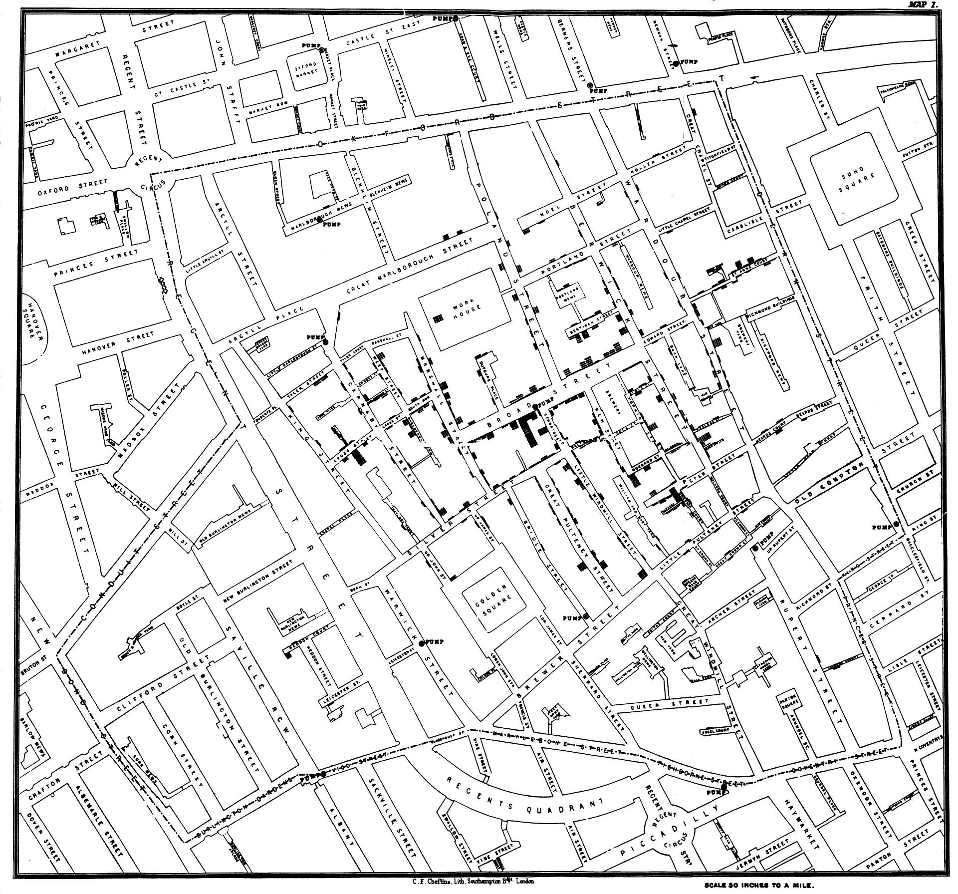
We have long mapped diseases to grapple with their causation. Even before the bacillus of a disease might be known or seen, the founder of modern epidemiology, John Snow, critiqued miasmatic theories of contagion by mapping the distribution with which cholera spread across London neighborhoods during the 1854 London epidemic, visualizing the disease as a social network of contagion by a dot map of neighborhood outbreaks that used a dot map to as proof that “nearly all the deaths had taken place within a short distance of the [Broad Street] pump” whose water was a vector of transmission. The distribution of mortality around public fountains provided a basis to demonstrate vectors of contagion for Dr. Snow, and by mapping all deaths from cholera to have occurred in recent years in relation to one pump on Broad Street in relation to London’s thirteen city wells by a voronoi diagram.
By locating each and plotting the distribution of deaths from cholera in the city in relation to the significant incidence of deaths form cholera near specific street-pumps revealed a way to grasp infectious transmission from the Broad Street pump that embodied a new notion of contagious diseases that challenged miasmatic transmission—making for the first time a clear spatial argument about how disease existed and moved in an urban environment, and presented a second map, with clearly traced polygons to indicate routes of transmission to the local parish showing routes of walking by which the disease was transmitted—using the recent mapped deaths from cholera in London Edmund Cooper tabulated—
—in hopes to encourage a level of civic engage about the origins of cholera infections that had plagued Londoner’s for twenty eras in the city’s fabric.
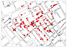
The source of deadly infections that this famous data visualization revealed suggests the communication of fatalities by a clustering that indicated clear routes of the spatial communication of a viral infection, focused on a large subset of deaths in close vicinity to the Broad Street pump, even without bacteriological or microscopic evidence.
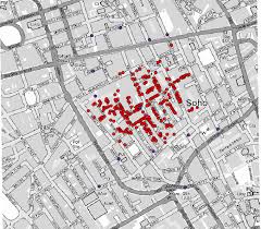
The exact distribution Snow organized contrast to the terrifying distributions of the deaths of migrants seeking passage across the border, which resists any extraction of an explanatory framework or conclusion, but raises questions about the inhumanity of the terrain we have created.
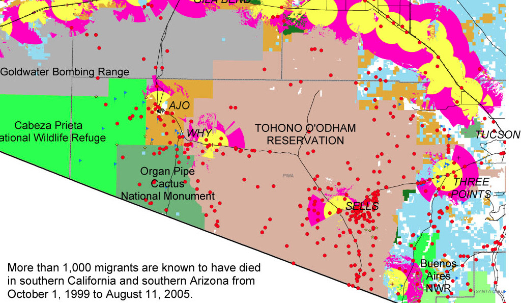
Dot maps of migrant deaths follow no such clear distribution, and has no sense of transmission form a single site. It forces us to acknowledge the deep problems of the criminalization of immigration on the Mexican-US frontier by charging its human costs. The sites of mortality from hunger and thirst are tragically dispersed over a far great undefined space, but embody the human costs of existing border policy, even a decade before Donald J. Trump used the management of the southwestern border as a campaign talking point to pole vault into public politics.
No similar diagrams can be drawn to elucidate the range of dead bodies discovered in the desert of migrants who were attempting transit into the United States for better homes: can one better explain their deaths b a virtual miasma of cruelty that fills the air of the border zone. Their deaths were caused by dehydration and starvation, as well as cold, but suggest nothing so much as a miasma of neglect. The distribution of deaths of migrants in the Organ Pipe Cactus National Monument, adjacent Cabeza Prieta National Wildlife Reserve, and O’Odham Reservation already illustrated a dereliction of national responsibilities.
The map is a deeply tragic reminder of the loss of life that is forgotten in the dry expanses of these deserts where the border, such as it is, lies, and the distinctly disturbing regime of a lack of interest or care for human fate that—even with the mortality of children in detention camps at the border—still can stretch incredulity at the evidence it offers of a large theater of cruelty. They recall the denial of burial to the bodies of enemies in the ancient world, left as prey to dogs and vultures: the Enlightenment jurist Giambattista Vico faced considerable difficulty explaining to his readers that there was a time when the bodies of anyone was left unburied in an earlier age in his Scienza Nuova, “an inhuman custom—so contrary to what the writers on natural law of all people’s claim to have been practiced among any nation— . . . which [once] prevailed among the barbarous peoples of Ancient Greece,” described in Homer’s Iliad, and at which he marveled as “crude, coarse, wild, savage, volatile, unreasonable and unreasonably obstinate . . . and foolish unreasonable customs,” far removed from his own age and from the imagination of his readers, so “discordant” was it with our own civil age. Yet the unburied dead whose bodies have been located in states of extreme decomposition along this border zone reveal a discordant reminder of the return of such an inhuman custom on the borders—and within the borders—of what we consider is a region that is distinguished and administered by civil laws. Whether this region can be rightly considered a region of lawfulness or civility seems to be raised and put on the front burner by the discovery and attempted identification of the human remains discovered lying in the desert, often dramatically decomposed, of migrants’ bodies dating from the administration of George W. Bush.
If Vico could scarce imagine the barbarity of leaving bodies exposed to the elements even in war—and the spectacular cruelty of the dragging of the body of Hector around the perimeter of Troy three times—among those who “were held to have spread humanity across the world,” given the sheer physical disgust of leaving the body unburied, and given that “all gentle nations certainly concur that souls [of the unburied] remain restlessly on earth, wandering around their buried bodies,” from Guinea to Peru to Mexico to Virginia to New England to Siam, the readiness of Christians to leave the dead unburied by the border, if not intentionally, haunts the border region with its own inhumanity. The violence of this early heroic age was before the age of laws of nations, for Vico, and belonged to the age of “violent and impious men who dared to enter the cultivated fields [] in pursuit of the weak who had fled thither to escape them,” and belonged to “the vulgar customs of the barbarous Greece” of Homer’s day, and adequate burial in fact constituted one of the three institutions of human society—with marriage and religion—in ways that betray the huge remove of a heroic era, which incredibly lacked burial customs or rites, from our own.
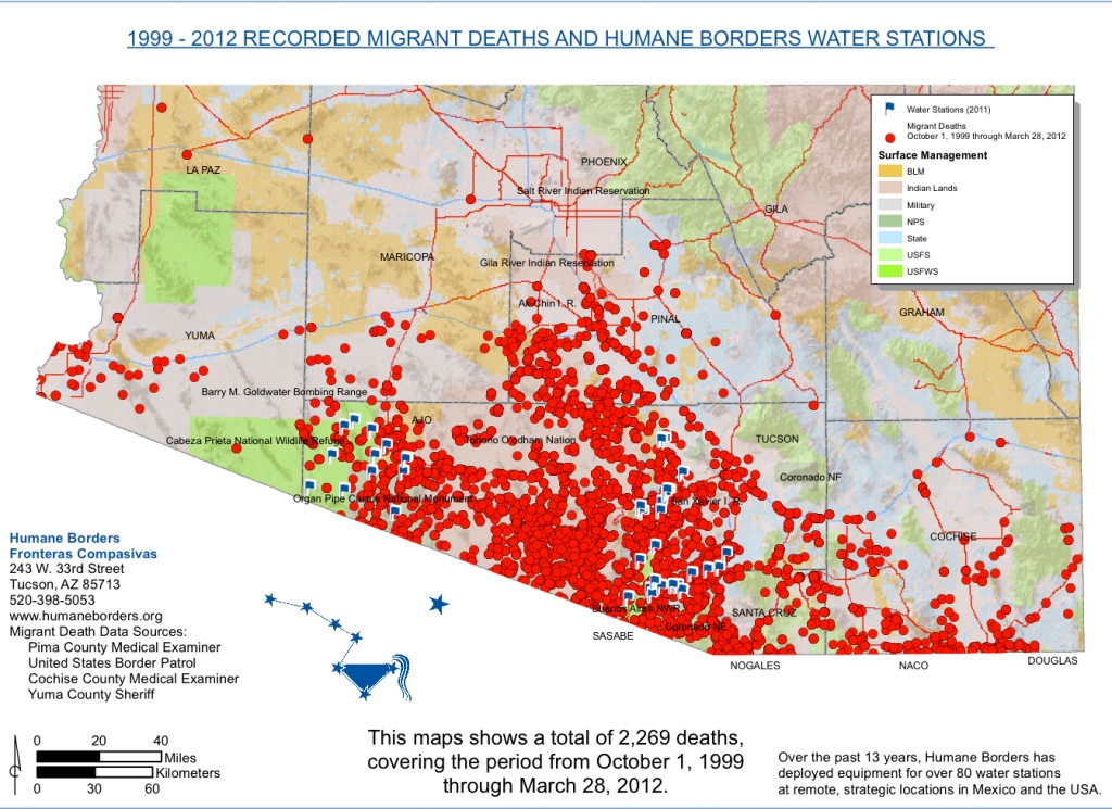
Yet the abandonment of unburied bodies has returned in the no-man’s land of the US-Mexico borderland, where the abandoned bodies of would-be migrants fall between governing bodies and accepted customs. Migrants that were stopped during the course of their attempts to reach a new life in the US were clustered at a distance from the border but reveal the amazing distances many undocumented migrants travel before they collapse, without food, and most often out thirst and dehydration–leaving them exposed as “prey to dogs and vultures” in the very horrifying ways that Vico was so horrified. The recent spatial distribution of such abandoned cadavers and corpses, left without any rites of burial, force the viewer to scrutinize its mute surface of dots against a deceptively pastel base map as if they might magically be able to glean or recuperate the silent, forever-lost stories of migrants who lost their lives attempting to cross the border, and the stories of whose travails and travels can never be told. The ends of their lives, reduced to the finality of a bright red circular dot in the data visualization, out of scale, arrests attention but is disarmingly and alarmingly flat, resistant to any further narrative or even identifiable name. Over 2,000 dead migrants whose bodies were retrieved at a significant distance from the border suggest their desperation to make their way across the border by clandestine routes, and the extreme climactic difficulties that they face, with few adequate provisions for crossing deserts whose expanse they feel forced to travel to search for jobs–risking their lives to do so.
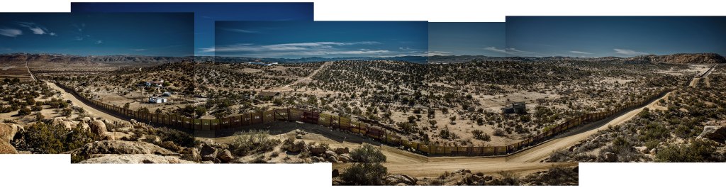
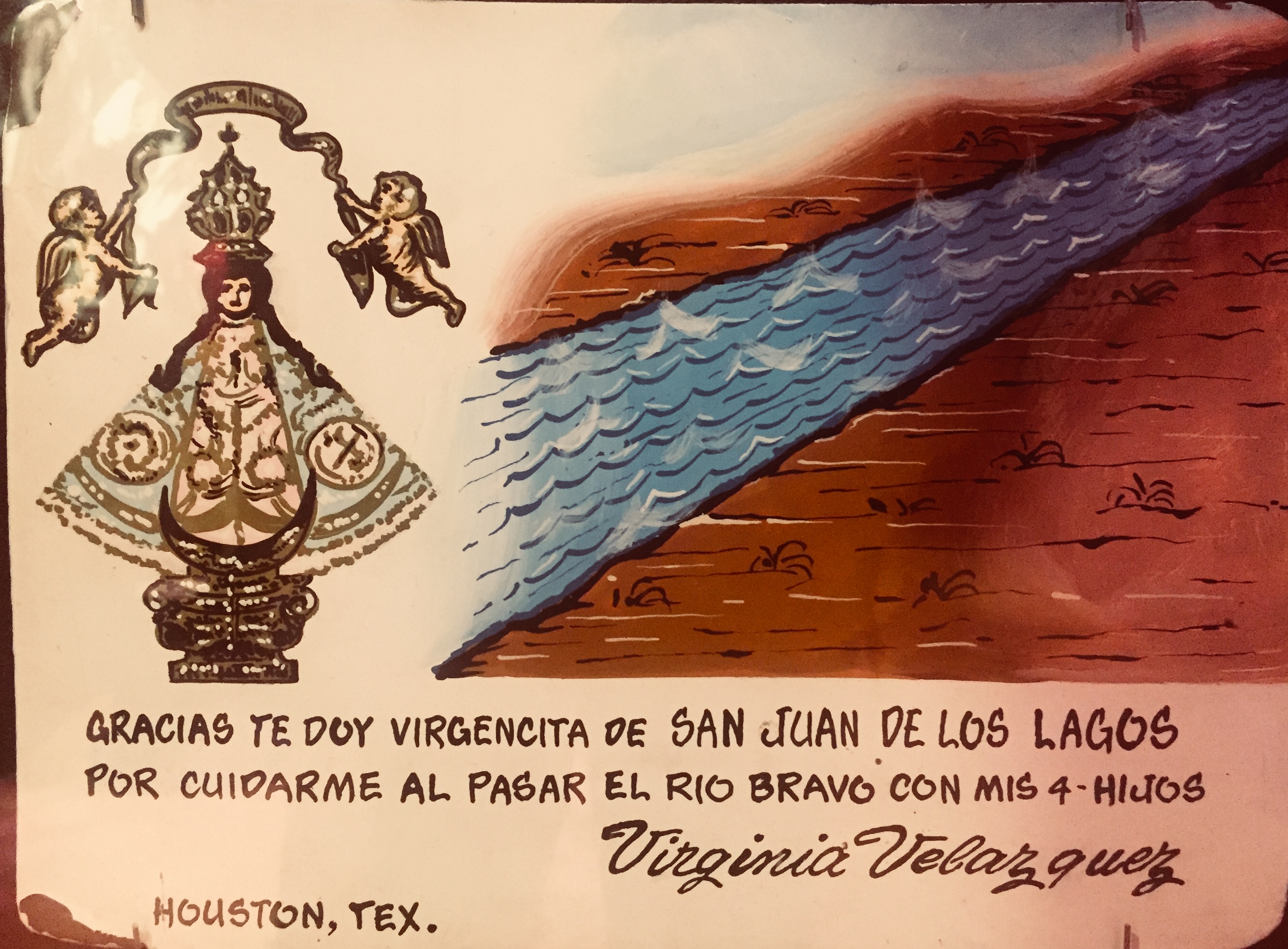
If the many migrant deaths of those attempting to cross the border between the United States and Mexico are often expressed by crosses that are hung on sections of the fragmentary “border wall,”—
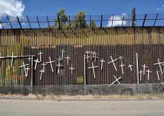
—the precise distribution of the dead in sites of their death is rarely preserved in public memory, and the archive of dead migrants who did not survive passage is rarely assembled as a geospatial record.
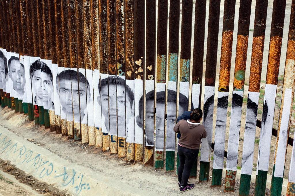
The number of the dead remains but a fraction of those who have actually died attempting to travel north, leaving detritus and lost objects in their wake that only beg deciphering as images. For although their overlap suggest something like a clustering that might belong to an external infective agent, the alarming nature of the red points call attention to the human costs–and the anonymity of lives lost–that are the victims of the intense dangers of border-crossing that migrants accept and undergo, who we have forced to accept and risks of dehydration, heat stroke, hyperthermia, and starvation which have killed them.

If the deaths of those attempting to cross the border will probably never be know with precision—and is often lost to oblivion—the recovery of human remains affords a grim picture of the actuality of recovering the dead, and the attempts to name, identify, commemorate and memorialize their fates as well as prevent the loss of their identities, despite the jarringly abstract geospatial symbology of this map, and the minuscule proportion of those remained that have been so far identified.
This project of memory and memorialization, echoing the imagery of northward passage in the famous Underground Railroad taken by fugitive slaves taught to recognize the handle of the Big Dipper to follow the North Star to find their path to freedom, “Follow the Drinking Gourd,” the symbol of the constellation has been adopted by the Humane Borders organization which has identified remains and sought to allow them offer needed geospatial assistance to migrants in their search to find a path north.

