It is pretty hard to imagine anything as scary as the intentional clearing of The Jungle near the French port of Calais. The dismantling by local police of improvised structures of lean-to’s, corrugated metal, stretched plastic tarpaulins, wooden structures, and improvised settlements that had sprung up near the Port of Calais for three years had housed many families of migrants from Afghanistan, Eritrea, Syria, Somalia, and Sudan; the sprawling shanty-town being disbanded was not only symbolic of the failure to address the growing refugee crisis in Europe, but created a human map of migration of considerably compelling power as a center of residence: stuck together by duct tape and affixed in an improvised canteen, the map was symbolic of arrival beyond borders. In a time when “place” has lost much meaning, the map affirmed The Jungle as one. For those who had managed to travel to Calais to seek illegal entry into Great Britain to claim asylum otherwise so elusive for these victims of political persecution and economic crisis, pressed by necessity and human rights violations to leave their countries.
They had come to seek the status of refugees on the coast of northern France. Yet as Calais settlements have provided a target for migrant-bashing and a sort of political football for the French government and Prime Minister, as migrants waiting to travel to the United Kingdom by subverting the border controls, risking their lives by clandestine travel underneath trucks or in ferries, or any transport through the crowded Eurotunnel in whatever illegal way presented itself. Calais’ stateless settlement is created by one nation seeking to restrict entrance of foreigners, having pushed its borderline onto the soil of a nation that also doesn’t want to offer migrants asylum, but where they have made their temporary home, even as both states restrict their movement, as both border controls and anti-migrant fascist groups both concentrate their presence into a confined space–the “Jungle,” from the Pashtun dzhangal, on the outskirts of town, to make their homes on an overbuilt border that has been increasingly defined by a visible security apparatus, designed to prevent entrance into British territory by migrants to claim asylum. And the clearing of the encampment by French police, who moved in to erase any traces of habitation and remove migrants from the region, seems both a misguided local attempt to resolve an international problem of housing and naturalization, whose frustration has given rise to right-wing political forces in Europe and much of the world.
Most migrants had arrived in Calais with hopes to find their way to the United Kingdom, hoping to gain transit across the twenty miles of ocean by illegally boarded trucks, or trains. But the recent decision to build a concrete wall along the border to prevent its crossing, and to disband and remove the camps, seems a failure to deal with a growing migrant crisis. If the compass rose on the cardboard hand-made map pasted on one of the social centers in the settlement camps provided a point of orientation to the world where they sought to find a place for themselves, the crowded habitations of migrants from different nations on the map suggests less of a fantasy map than the immense geographical range of migrant families who had settled in tents on a stretch of landfill beside a highway and sandy shore, mid-way between Paris and London. The map seems also a confirmation they had arrived in a safe community beyond national borders.
The creative cartography, without borders and boundaries, and foregrounding a sinuous cartography of roads, as if a surrogate for migrants’ ongoing travels, is an imagined cartography but not at all one that is imaginary. The hand-drawn map was affixed by duct tape in a distribution center of clothing and food in the Calais Jungle, to orient arriving migrants and their families to where they had recently arrived, and might rejoin similar linguistic groups of co-nationals, but also suggests the blurred world of migrants, who live outside of any previously recognized borders, and on a quite different map. For while it reads at first as a fantasy map, the assemblage of global refugees gave rise not only to a common cry–“Fight the Border Everywhere!”–offered a clear sense of pride and local belonging, and a triumph over adversity that was all too real. The map indicated sites to find hot food provided daily, water sources, health centers, and houses of worship and where migrants congregated from the Eritrea, Iraq, Afghanistan, Pakistan, Syria or Iran.
The map drawn in marker on cardboard boxes is as improvised as the shelters of The Jungle, built of jerry-rigged tarpaulins, wooden structures, corrugated steel sheets, and bits of post-industrial detritus converted to living quarters. But it presents a sturdy and resilient image of a world view, using recycled cartographical imagery and legends, from a compass rose to point to England and “Here be dragons” to suggest the dangers of riot police beside the motorway and tunnel to England. The hand-drawn map has been recently interpreted as evidence of the failures of European immigration policies, depicting a “geography of imagined communities” which exposes policy shortcomings, for migrants who arrived in The Jungle, it presented a sense of place where they had arrived. If “place” can hardly have been stable for the refugees who had taken such extensively varied itineraries to reach the coastal port town of Calais, the map confirmed their arrival at a place of common solidarity, as much as their outcast status and transient status, rather than a failure of states to process their claims to asylum. For a group of migrants who had travelled such great lengths from so many areas, viewing the map provoked less of a sense of dislocation than of arriving at home, if not a shared pride in local resettlement.
If most images of The Jungle convey its improvised nature as a quite crowded sea of brightly colored tarps and corrugated metal roofs, the hand-drawn marker map shows The Jungle as a dramatically well-ordered space, concealed on a system of roads, linguistic or ethnic regions, with its own school, health center, and markets. Located close to the Ferry Terminal and Eurotunnel. True, The Jungle was a sort of legal limbo, whose sites of encampment near repurposed shipping containers had created a sprawling virtual microcosm of the refugee crisis. But although it existed for years, the expansive settlements seem to have been poorly mapped. Located just three miles from the downtown of Calais, in uncomfortable proximity to the shopping district, the presence of crowded tents in the Jungle from 2015, including toilets, electricity, and food arose as an effort to stop migration to England–but grew as its conditions attracted refugees hopeful of reaching England. When Francois Hollande judged the settlements both “undignified” and “not acceptable“–“We cannot have such camps in France“–and promised the rapid expulsion of the settlements in September, he boasted to restore and reinstate border without any engagement of migrants’ real needs.
The Jungle is perhaps less often closely watched that poorly mapped–as it is below, by a dark superimposed grid, without a human face. But it has been increasingly difficult to face in European politics, since it so clearly embodies the inability of Europe to deal with its refugee crisis, and the inability of finding governmental solutions to migrants’ arrival–or to accommodate the hundred migrants who recently arrived daily in the French port town, close to the border controls hoping to gain passage by ship or car. So strong it the hope that many wish to stay nearby, refusing to abandon hopes for future transit across the twenty miles of sea to England. A month after publicly confirming the joint French-British construction of a “Great Wall of Calais” costing $22.65 million, promised to stand at thirteen feet high of unscalable sheer concrete, the destruction of the Jungle began: the costly project, as the dismantlement of the camps, has more to do with border politics, of course, than the plight of migrants seeking asylum–initially Iraqi Kurds, but increasing Sudanese, Eritreans, and Ethiopians and Afghanis. Indeed, with the commitment to the new reinforced border boundary to be built in Calais, unprecedented in size, the erasure of the camps that existed of migrants were set to to be definitively cleared.
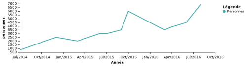
The above map, designed just before authorities proposed to clear the southern half of the camp settlements in early 2016, that they described as a “humanitarian project,” or “soft demolition,” sought to defuse the growing political debates and to restrain the already growing number of migrants who had arrived at the port town seeking passage, which they hoped to limit to 2,000–even as the numbers present were already above 5,500 according to the humanitarian organization Help Refugees–the difficulty to put faces on the many people who came to crowd the densely populated tent-camps was clear in the attempts to provide some humanitarian aid, balanced with fear of become a magnet for further refugees as the size of the Jungle settlement grew. While French police control the region and sought to prevent migrants from reaching transit by car or ship, and cleared tents and shacks from many areas, authorities opened a shelter in the camp’s northeastern region, adding 125 repurposed metal shipping containers to offer shelter for 1,5000 migrants as temporary housing atop the port’s sandy dunes. Many migrants rejected the sparse living conditions, but the multi-ethnic camps grew, nourishing hopes of future resettlement. Rather mapping migrants as outsiders who had only recently crossed the borders and boundaries of Europe, many of those who had arrived in The Jungle were seeking to rejoin relatives or former migrants who were already living and established in Europe.
Similar encampments had appeared at Calais since 2003, and had been present since the late 1990s in some form, but the Jungle dates from early Spring, 2015, when it emerged as a destination and point of departure. But their recent ballooning provoked the forceful dismantling of the structures, as if to erase any trace beside the repurposed shipping containers brought to house migrants. And as it grew, it became an increasing concern of French citizens near Calais, giving rise to anti-immigrant sentiments, barbed wire electrified fences along freeways and around the entrance to the Eurotunnel, and something of a national political football and deep source of embarrassment to the government, providing evidence of their inability to process immigrants arriving from Africa and the Middle East.
The increased attraction of migrants to Calais is particularly curious as it represents the arrival of the disenfranchised communities of the world at on e of the highest concentrations of international capital. Indeed, the increasing number of migrants attracted by the highly profitable Eurotunnel, which runs the tunnel as a concession through 2086, or of 90+ years, which already turned an unimagined annual profit of €100. The concessioning of the tunnel has encouraged the outsourcing of monitoring of human traffic or transport across the tunnel–imagined only as a route of moving goods–to a private security firm of 300, a non-state army that is now headed by an ex-police chief and ex-army colonel, and has assiduously worked to install an array of surveillance and security technologies to prevent the smooth business of trade across the Channel, as the profitable chunnel works to reduce its €4 billion debt, even after having had a record year in 2015 in transnational trade, and is desperate to prevent the “problem” of migrants who have been based in Calais to reduce its income from freight and the Eurostar. The range of security forces and companies implicated in Calais border violence–supra-national entities such as Trascor; Vinci; Logistic Solutions; Jackson’s Fencing; Mondial Protection; L3; Clearview Communications for biometrics–reveal a congestion of commerce and wealth beside the world’s destitute that creates a bizarre hybrid space on the edge of the national border.
When running for President of the United States, Donald J. Trump already betrayed a shaky knowledge of the territory. He didn’t want you to think that a wall had already been built along the southwestern boundary of the United States. Now occupying the Oval Office, he seeks to convince the nation that it is in fact being built, and that the need for a permanent, impassible “wall” exist, despite Congress’s refusal to allocate new funds for a “border wall.”
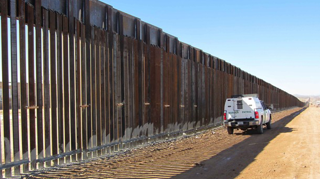
But the massive show of force of cyclone fencing, regular patrols, and bullet-proof barriers set a precedent of border fencing since the 1990s, and something like a precedent for redrawing the nation in ways that are designed to resist changes in a globalized world. In ways that Trump has put on steroids as a racist divide between outsiders and “Americans,” and used as a vehicle for an “America First” agenda, as filling a need to remap strong divide between nations that would replace an “open border,” able to protect the nation, the “border wall” has become fetishized as a paradigm of the unilateral mapping of global space–in terms of actual sovereign bounds, and as a way to remap the nation’s involvement in the world and shuns international responsibilities. If the rhetorical role of the “border wall” has replaced its actuality, and mapped the proximity of the nation to the border in both duplicitous and quite dangerously simplified ways, only by returning to the border, and viewing the existing scars on its lived landscape and the traces of the migrants who have crossed it, can we unmapped the mental mapping of the border.
The effectiveness of the current complex of bollard fencing, barbed wire, steel fencing, cyclone fence, prison-wall like bars, and other obstacles has become one of the largest collections of military surplus in the United States, an accumulation of military materiel that appears designed to remind those who see it of their absence of rights. As much as a defense against globalization or immigration, the border wall stands as a fiction. Although some Americans lend credence to the idea that a barrier along the border could prevent “unlawful” entry of the country, whether such entry is in face unlawful–and what sort of balance of justice would be reinstated–is unclear. The frontier is constructed as site for denying justice, and a denial of human rights, both embodied in the a massive build-up of military material and show of force in its regime.
The construction of the border as a region that denies civil and legal rights–a “negative space” of sovereignty and liberty–has redefined its relation to the state. While the project of a wall seems to mirror the lines of a map that would separate two countries, the simple division of national zones and spatial division more of a fiction in the transborder region. The compulsion to create a map that was present on the earth–a sort of scar between two regimes–depends on defining a space outside of either state, overseen by someone who has no interest in securing rights of its inhabitants.
In this sense, Donald Trump is the perfect messenger of a circumscription of personal rights. When Trump urges the nation that no choice exists save a wall– “We really have no choice but to build a powerful wall or steel barrier”–citing that any agreement with Congress for “a fair deal” to be far off, he invokes a notion of fairness and justice that he argues it would create a sense of security–and promote a sense of national security as well as personal security–but relies on evoking the sense of fear and vulnerability that “open borders” conjure. Without any clear statistics or evidence for its value, save the magnification of border security, the need for a border wall is only a fantasy, based on an imagined. As someone who defines himself outside the political classes, and apart from an interest in preserving civil rights–or a sense of the role of government in the preservation of the nation’s liberties–Trump is perfectly suited to define himself in terms of the border wall, which he seems to be set on developing as a property.
1. The sense of justice or security is altogether absent from the landscape of the wall, and from its already heavily militarized region. The absence of place along the border is particularly striking as the accumulation of increasing obstacles to cross-border transit seem designed to preserve a sense of the integrity of the nation–and the safety of our own sense of place–in a world increasingly defined outside of the nation-state as a category, where “states” have decreasing presence or meaning for many American citizens, and most inhabitants of the globe.
In an era of the continuous extent of global space, where borders of nations are to a large extent rendered arbitrary in the virtual space of the meridians of the widely adopted Universal Transverse Mercator coordinate system–
–there seems an urgency that is more easily created of the need to define a boundary line, and to believe that the ideal border line of a national map can conjure the antiquated entity of the “nation”and defend it against the danger of migrating threats. Invoking the fear of the dangers of cross-border movements are so often epeated by the America First movement–“bad hombres,” rapists, murderers, or criminal networks, drug cartels, and multi-nationals that go beyond the current systems of state-based law enforcement, that seem designed to suggest threats that only a clear partition of territories can stop,
Migratory Routes of White Pelicans in the United States Originating from the Gulf of Mexico
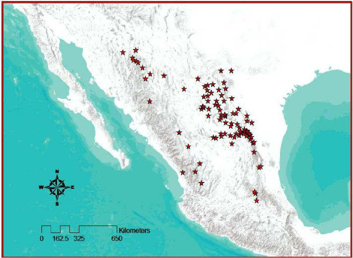
Historical and Current Sites of American Black Bear in Mexico
In ways that echo the growth of border walls world-wide–only fifteen existed in 1990; there are beyond seventy–the US-Mexican border barriers already constitute one of the most massive investments in wall-building–and the most massive project of wall-building that exists. Rather than offer a spatial division that can serve to protect the nation, or reassure us of the possibility of law enforcement, the complex created around the militarized complex serves only to suspend individual rights, as much as to guarantee the law. Ie exists in an atmosphere of compromised legality, if not lawlessness, in the name of security.
Rather than see to create a secure spatial division, the border has been transformed into a deeply hostile landscape, a site seeking to erase or obliterate any sense of individuality, however much the wall is identified with justice or national protection against the threat of criminal elements. The rhetoric of wall-building that invokes justice indeed obscures the utter injustice of its construction. The 2,500 mile barbed wire fence that India is building to separates itself from Bangladesh, the US-Mexico border wall would be by far the longest such wall in the globe, as if a bald rebuttal to globalization and a declaration of American self-interest: if intended to illustrate American strength against the specter of the threat of the cross-border movement of workers, criminals, or lawlessness, it claims the ability to remove surgically the territorial United States from the dangers globalization has wrought.
In this sense, the project of wall-building is a promise to protect the sense of “place” of the nation. At the same time as our sense of the nation and our sense of place has dramatically altered for reasons beyond any individual nation, the wall reified the nation as an entity, even as the distinct nature of the nation is unclear. John Berger observed grimly, but surprisingly presciently, toward the end of his life, after touring the Occupied Territories in the Middle East, that “The present period of history is one of the Wall,” shortly after 9/11, he foretold the policing of border-crossings and humanity, ” . . . concrete, bureaucratic surveillance, security, racist walls.” The new definition of walls that are defined to separate hoary categories of race or ethnicity are increasingly evident in all too frequent attempts to create barriers of regional protection. They are based on the sense that national survival depends urgently on such massive projects of enclosure, as if such projects could be isolated from their huge effects and psychological consequences for those who might confront them on the ground.
The current emptying of words–emergency; invasion; criminality; violence; human-trafficking–make them tags to activate the border within the political imaginary, but conceal the actuality of the borderlands where the military is already present, and the lands are already quite secure–and quite vacant of habitation.
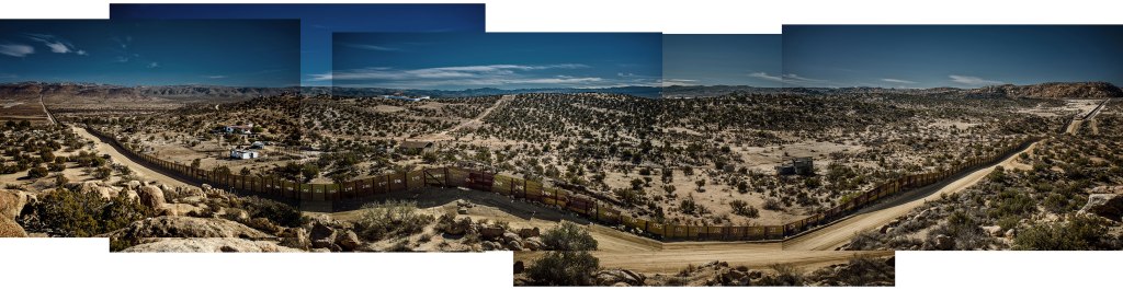
2. The place of the amassing of materials and military materiel along the US-Mexico border seems designed to create a new experience of the border, and to make it scarily real for those who might seek to move across it or to regard it as part of a zone of permeability. The exquisite photographs portraits of the wall by west coast photographer Richard Misrach has worked to document the extent to which border barriers have changed experience of the border crossing.
The barriers progressively built on the southern border of the United States reveals a new heights of the costs of bureaucratic surveillance in the name of border security. As if in a second episode of his classic Desert Cantos, begun in the 1970s, which, Geoff Dyer noted, “record the residue of human activity inscribed in these apparently uninhabited lands,” in an attempt to explore “the multiplicity of meanings in the idea of desertness.” The residue of the human is even more haunting in Misrach’s new project, and the photographs that result of human traces on the border, because they are emblems of the disenfranchisement of the borderlands that hauntingly parallel their military build-up. One might even say Misrach interrogates the landscape in his work–if the word didn’t tragically resonate so closely with the state-security apparatus on the US-Mexico border. Misrach dwells on human traces that lie around the militarization of the borer regions–from the cultural detritus left by cross-border travelers, left on migrations, the security apparatus encountered at border, and the hollow loneliness of the massive redesign of its landscape capture the expanded military-defensive complex at the border.
This evacuated land is the region that Donald Trump has come to champion as a basis for defense from national emergencies. The argument that the border is understaffed erases the rewriting of the transborder landscape that has already occurred. Misrach’s contemplation of magnificent vistas, broad traces of the inscription of authority at the border, and the reduction of the human, are truly Kafkaesque in their nightmarish reduction of the individual before the inscription of authority in its landscape.
3. For since the definition of the US-Mexico borderline as a line of passage monitored by the border patrol back in 1924, the expansion and militarization of increasing sections of border wall is in part a spectacle of state. Their growth reflects increasing concern not only with the border, but the militarization of a border zone. But increasingly, such a zone seems sealed off form much of the country, and is rarely fully comprehended or seen, but rather invoked as a specter that needs to be expanded to establish national safety and economic security, even if its expansion has already occurred in a hypertrophic fashion, long before Donald proposed to build a “beautiful wall” to prevent crossing the US-Mexican border. If the expression reveals a lack of compassion, its problematic nature is even deeper: it reveals Trump’s peculiar identification with an apparatus of border protection, and of human containment, and the removal in his eyes of that apparatus from a discourse of rights.
Trump has celebrated the wall as if it were a new hotel and building project–asserting that he has the needed expertise to build and design it. Trump presented himself to the American press that he was perfectly suited to such a task, since building is what “I do best in life.” “I’m a great builder,” he assured his audiences, with considerable self-satisfaction, to suggest his suitability to the position as chief executive, despite his lack of political experience; defining himself apart from other political candidates in the vision of the nation that he supported, Trump added with evident satisfaction, “Isn’t it nice to have a builder?”
Precisely because he came from outside the political sphere, and outside the government that preserves and respects individual rights, he has been presented as a perfect fit for a region that lies and has developed as outside the securing of individual rights. By having a “builder” of the nation and the nation’s identity, he suggested, rather than a politician, he could guarantee the increased presence of the military along the nation’s southwestern border, and indeed promised to dedicate an increased amount of the national budget to the defense of this borderland. Precisely because Trump lacks interest in guaranteeing or preserving the rights of migrants, or rights of asylum to the nation, he is a perfect custodian and symbol of this over-militarized zone without rights. As a man without military experience, but cowed by military authority, he has become, as President, the perfect surrogate for the stripping of rights for people who try to cross the border.
Trump’s promise is that the continuous wall, to be payed for only upon completion, would remove deep worries about border security. Widespread national concern about cross-border movement since the 1990s have led to the investment to making the border more physically and symbolically present to potential migrants than it ever was–no doubt reflecting an inflated fear of illegal immigration and the dangers of their immigration by fortifying what was once an open area of transit and rendering it a no-man’s land. The number of US Agents stationed along the border has almost tripled from 1992 to 2004, according to The Atlantic, and doubled yet again by 2011, even as the number of US federal employees shrunk. Investing in the border by allocating over $4 billion each year created a concept in our spatial imaginaries we have not fully digested or mapped, or assessed in terms of its human impact, despite increasing appeal of calls for its expansion and further consolidation–even as the further consolidation of the border zone has made migrants depend on drug smugglers and other illicit trade in hopes for guarantees of cross-border passage. And in an era when a large portion of Americans seem to interact with government through the TSA—Transportation Security Administration–or NTSB–National Transportation Safety Board–the fear of external threats to the public safety seem incredibly real.
The inspired gesture of a monumental wall to be built across our Southern Border with Mexico, if a sign of weakness far more than one of strength, obliterating hope for the promise of a future, as Berger noted, intended to overwhelm and oppress as a monument to decadence and American insularity. Outfitted with not only walls, fences, and obstacles but checkpoints and surveillance cameras, the US-Mexican border has become a pure hypostatization of state power. And although Trump’s promises to build a “beautiful, impenetrable wall”–“He’s going to make America great, build a wall and create jobs,” folks repeated on the campaign, as if these were causally linked to one another–the massive construction project has been revised, as the “great, great wall” promised at rallies was scaled back to a fence and confined to “certain areas”–with the odd reassurance that “I’m very good at this, it’s called construction,” while acknowledging that the wall was “more appropriate” only in “certain areas.”
Does Trump have any sense of the massive investment of capital that already exists on the border. The promise of dedicating as much as $26 billion–even $30 billion–to such a soaring, precast concrete monument along the border, standing as high as fifty feet, was a mental fantasy, and election promise, but filled a need for ending perceptions of its permeability grew so great that his advisers see the need to warn folks “it’s gonna take a while,” but promising the ability to do so by fiat and executive order and reallocating funds for immigration services; others demur, “it was a great campaign device.”
At the same time as deporting hundreds of thousands of immigrants now deemed “illegal,” the Department of Homeland Security has effectively rendered the border a militarized zone, interrupting what had been as late as the 1980s was a relatively porous transit zone on which both countries’ economies had depended: the accumulation of capital on the border has expanded what was once a simple line to create obstacles to human movement challenging for viewers to process from a distance, or to map as a lived experience. Of course, the existence of the wall has created a blossoming of illegal trafficking, as migrants are forced to depend on smugglers to help them in their quest to cross the imposing border, augmenting the illegal activity that occurs along its path, under the eyes of the many employees that guard the expanded border zone, in a far cry from the border patrol of years past.
The accumulation of obstacles for human transit contrast sharply to the old border fences that they have long rendered obsolete. The growth of the border zone dates from 1986, when granting of “legal” status to Mexican immigrants in the 1986 Immigration Reform and Control Act (IRCA) had the consequence of redefining Mexican migrants as “illegal.” The investment in increased construction of the border over thirty years to the “illegal” immigrants who were surveilled by the U.S. Border Patrol at the highly monitored militarized border, designed to thwart unregistered immigration. The argument that the old border fence is now outdated, and contiains gaps–
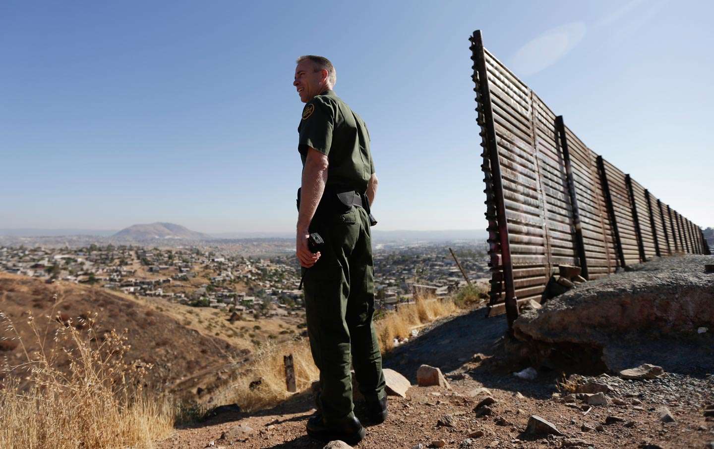
AP/Gregory Bull: Border Agent Jerry Conlin looks out over Tijuana beside old border fence
–has been demonstrated repeatedly in maps. And since the Customs and Border Protection agency dedicated to “securing the nation’s borders” has come to expand the border between the United States and Mexico to prevent any possibility of human transit, reifying frontiers in ways that are nicely stated in one side of the pin worn by the very officials tasked to secure the border by regulating cross-border movement. The mandate for U.S. Customs and Border Protection–“Securing America’s Border and the Global Flow of People and Goods”–is fulfilled by a range of devices of detection, surveillance and apprehension–attack dogs; choppers; drones; visual surveillance; horseback; speedboats; binoculars–that seem to expand an impression of total mastery over space in ways that are oddly ignore the human targets of the Agency.
The division of Border Services that is dedicated to secure the US-Mexico border has attracted a level of investment that multiplied the increasingly inhumane terrifying ways, as “securing the border” has encouraged a material surplus and hypertrophic expansion of the border as militarized region that exists to obstruct human transit that is undocumented. The border-zone assumes an increasingly prominent place within the spatial imaginary of Mexican migrants, as it has become increasingly accepted as a militarized–and naturalized as such–within the United States at considerable costs. What are the consequences of such acceptance of the frontier as uninhabited lands? How can one confront the consequences of its built-up construction from the perspective of the border-crosser? How can one measure the human consequences of the expansion of this outright militarization of a space between two countries who are not officially at war?
The separation of customs enforcement from border protection led an increased amount of resources to securing the material border, independent of the enforcement of customs, with effects that can be witnessed in the broad expansion of the border’s expansion as an uninhabited policed area needing to be secured in the abstract–independently from the human traffic that passes through it.
It is difficult to process the expanse or scope of the expansion of the border or the imposing barriers to border transit that is intended to prevent unmonitored migration and indeed terrify migrants from crossing the border . The experience of the surplus on the border is especially difficult to capture from an on the ground perspective, distinct from the abstract definition of the border on a map as a simple line. For the investment in the border obstacles and barriers that have themselves created the terrifying idea of sealing a border to human transit, and protecting the entry of those newly classified as “illegal”–a category that was the consequence of the IRCA, and legislation that criminalized the presence of “undocumented” Mexicans in the United States, and the growth of apprehensions of migrants after the increase in the monitoring of the border after IRCA– and the later increase of border patrols from 1994, in response to the inhumane balancing of needs for Mexican workers with fears of an increased number of Mexican immigrants, as the number of “undocumented” migrants multiplied nation-wide to new levels. The increased militarization of the border to monitor all and any cross-border transit has created a massive expansion of border fortification under the Homeland Security Dept.
The result has been to create a shocking dehumanization of border crossing as attempts to cross the border in search of a better life have grown. And the response of Richard Misrach and Guillermo Galindo to recuperate the human experience of border crossing that is erased by most maps. Recent explorations by Misrach has called renewed attention to the expansive construction of the border as a human experience migrants face and encounter, and the new landscape of border-crossing that has been created across a new no man’s land. His attention to the remains humans have left along the wall–abandoned detritus and intentional markers of cross-border transit–remap the construction of the border zone so challenging to capture in a territorial map, and capture a new sense of urgency to confront the human rights abuses that have grown with the border’s senseless expansion, and the overbuilding of border barriers and borderlands as a militarized space.
For the accumulated military surplus along border boundary is less a clear divide, than a means of creating a territory of its own within the growing border area: Misrach’s recent photographs map intensive fieldwork of the region of the border that try to comprehend the scale of its presence for those on its other side or who traverse the border zone–an experience entirely omitted from even the most comprehensive maps of its daunting scale and expansion, which reveal the growing presence that “the border,” border area and the growing expanse of trans-border regions have already gained–a scale that can in part capture the heightened symbolic role that the debates about a border fence or barrier have gained in the 2016 United States presidential election. The notion only a wall could fill the defensive needs of the United States must be protected from those Donald J. Trump labeled “bad hombres”–we stop the drugs, shore up the border, and get out the “bad hombres”–is laughable, but was a lynchpin to fashion himself as a strong male leader.
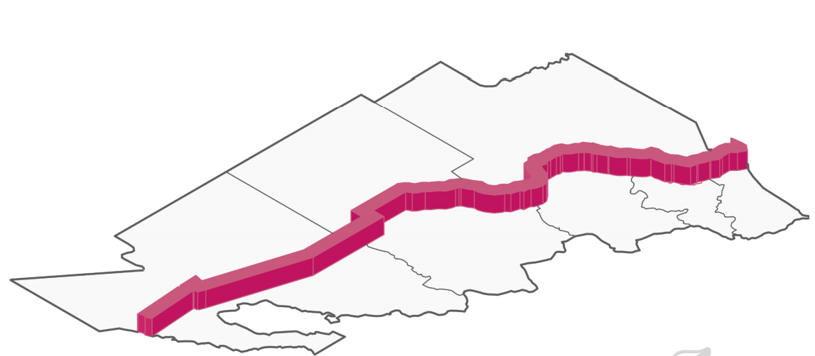
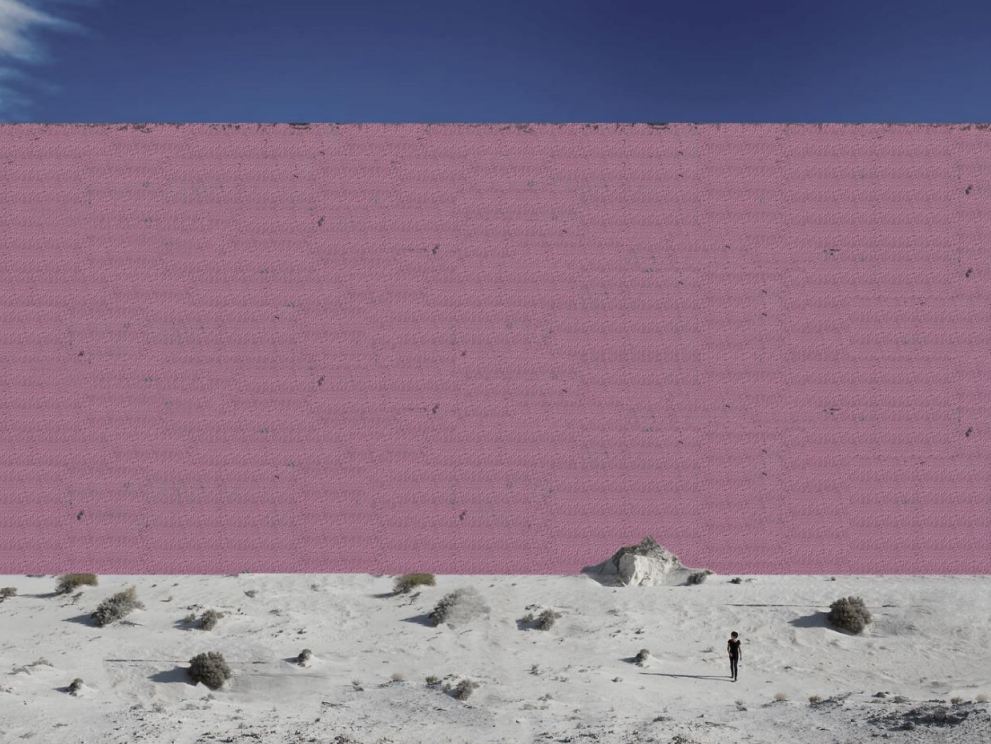
The grandiosity of the wall as a project of Trump’s megalomania led the architects at the Guadalara-based Estudio 3.14 to propose a version in hot pink, stretching along the 1,954 miles of the border, based on the work of Mexican architect Luis Barragán. The wall, including a prison to house the 11,000,000 deported, a plant to maintain its upkeep and a shopping wall, seems specially designed both to daunt migrants and offer eye-candy for Americans.
Indeed, such a “Prison Wall” reflects the deeply carceral function of the space of the border, whose systems of surveillance systems and technological apparatus make it less a space of transition than a site of expansive investment going far beyond the notion of border protection, both as a spectacle and expansion of territorial control. The hot pink wall offers a good substitute surpassing the expansion of border security in recent decades.
4. Indeed, as the transborder region has dramatically expanded with the expansion of cross-border trade since NAFTA in 2004, the expansion of the trans-border region has been widely neglected, and rarely mapped. The attention the photographic mapping of the human experience of border crossing–evident in the abandoned detritus and remains of cross-border transit–present a ghostly counter-map to the expanded border region.
This human map is all too often unfortunately overlooked, even with increased attention Republican presidential candidates have paid to remapping a closed border and constructing a border wall, a project that seems to erase or remove the broad area of cross-border traffic that occurs within the immense region that surrounds the physical border–whose sociological expansion is so oddly conveniently erased by any project of wall building along a region demanding to be recognized as being part of the United States.
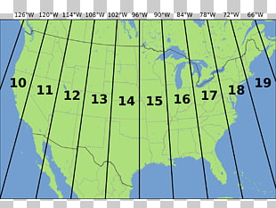
Most boundaries between states are regularly rendered in maps by dotted lines, as if to recall milestones–miliaria–placed at regular intervals on perimeters of lands or counties in earlier times. But the borer strip that is embedded in an expanded border area is a site of increasing surveillance that seems to engrave itself on the land. To map the proposed building of a fence along the 2, 428 mile border between Mexico and the United States reveals a the expansion of the policing of the national borderspace, erasing its past status as a transit zone across which people and goods easily moved.
In an age of globalization, borders are increasingly not only policed, but managed at a distance from their crossing lines–and increasingly invoked in Presidential elections as if they have become the primary charges of governmental management. Constructed to symbolize and symbolically represent sovereign authority, the overbuilt border seems staged a spectacle to impede human movement and to monitor and erase, individual experience, and to bolster the appropriately faceless authority of the state. Borders once the creation of shared conventions, are colonized by an apparatus designed to impose state authority on helpless people, and constructed at massive cost as artifacts that seem to exist to violently intersect with actual lived experience, confronting the cross-border motion or migration of populations, and concretizing the need for a fixed frontier as a need of the nation.
Getty Images
5. The huge popularity of advocating construction on a continuous border wall within Donald Trump’s Presidential campaign to seal the frontier along Mexico’s sovereign territory reveals the degree to which borders become a means to assert failing claims to sovereignty–even as it is an attempt to reassert the authority of an individual nation-state by unilaterally asserting its own abilities to police its bounds. How the border gained such broad purchase on the national imaginary is unclear, and may require another post–but the incommensurability of the alleged solution and the situation on the ground demands empirical evaluation. Revisiting the spectacle of the border and the suffering it creates engages broad advocacy to the continuous wall advocated alike by such presidential candidates like Trump and Ted Cruz–and the explicit violence they serve by of subjecting social life of border-crossing to surveillance in the name of national security.
And so it is apt that, in Border Cantos, a recent collaboration between photographer Misrach and Mexican-born composer Guillermo Galindo, the amassing of capital on the US-Mexico border is so eloquently documented and revealed as the brutalizing landscape that it is. More than any map is able, their collaboration bears witness to the expansion of the border’s imprint on the lives of migrants in incredibly moving ways, by asking viewers to evaluate the costs of the overbuilt structure of the fence, and assembling the artifacts and unintended traces that were found and collected about the border–traces accidentally left by actual migrants from backpacks to sneakers to books to children’s clothing and dolls to the spent shotgun shells that targeted migrants or the bicycles used to overcome border barriers–to reflect their social experience. These remains are human traces that do not appear on any actual map, of course, but are the remains of the violence that is enacted on how national boundaries are mapped–and the continued violence of the experience of border crossing that intersects with the broad security apparatus on either side of the border fence. As if to accompany Misrach’s photographs of the human geography of the borderlands–a largely empty space with few humans and only scattered human markers and material possessions–Galindo fashioned musical instruments whose playing is able to generate sounds in his own scores, specific to the surreal fraught space of the overbuilt borderlands, an eery score to accompany Misrach’s haunted landscapes, and remind us of the human presence that is so often necessarily absent from the images.
Such ephemera pale in contrast to the experience of migrants, to be sure, but offer both avenues of empathy and proofs of the brutality with which sovereign authority intersects with the mundane everyday at the border walls, in the built space that runs across the emptiness of the desert borderlands.
Mortality is mapped to gain a grasp of geographical distributions of illnesses over space. The mapping of death helps to embody the pathways of disease, and allow us to see otherwise inapparent vectors of transmission, which have historically provided crucial ways to assign meanings to a disease’s effects and pathways. In ways, the map manufactures and embodies the pathways of a disease’s infectious spread: the rise of deaths in the borderland between the United States and Mexico can only be mapped as a dereliction of national responsibility that charts an erosion of civil and moral codes. The recent erosion of civil law and attacks on immigration law conceal a longstanding withdrawal of responsibility along the border, opening the way to creating the borderland as a military jurisdiction—rather of civil law.
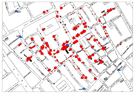
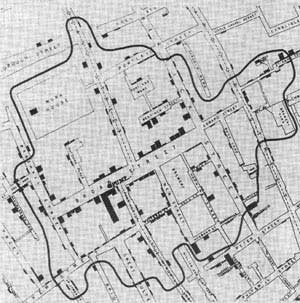
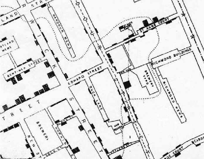
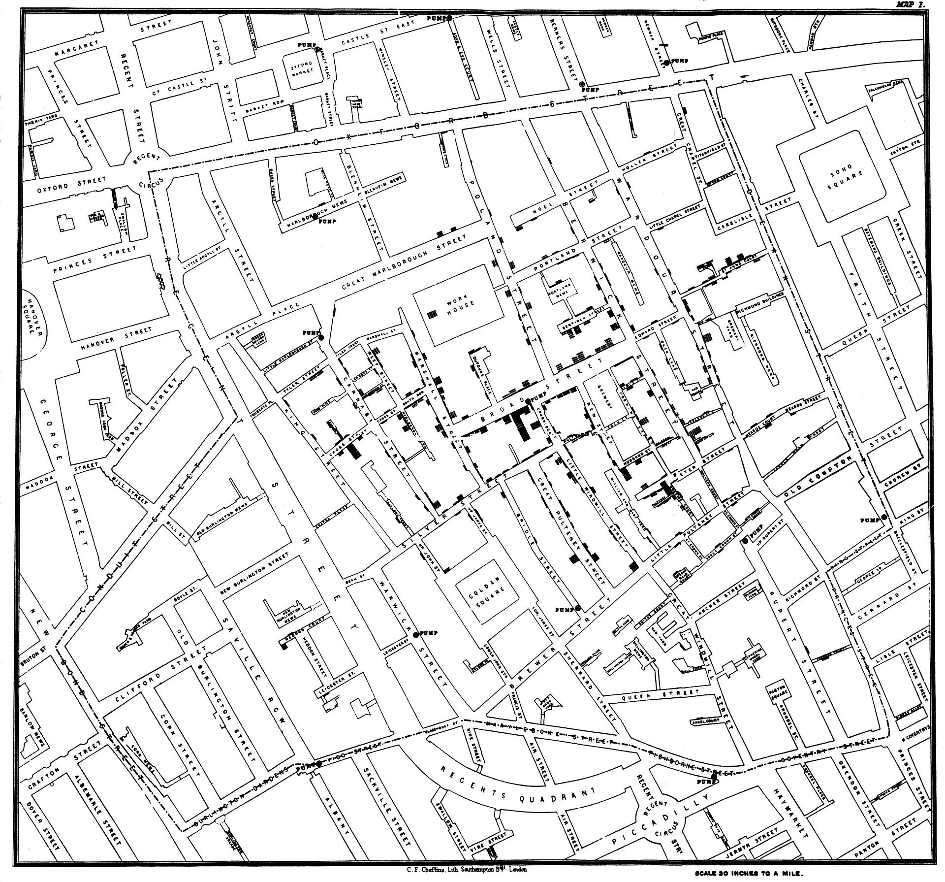
We have long mapped diseases to grapple with their causation. Even before the bacillus of a disease might be known or seen, the founder of modern epidemiology, John Snow, critiqued miasmatic theories of contagion by mapping the distribution with which cholera spread across London neighborhoods during the 1854 London epidemic, visualizing the disease as a social network of contagion by a dot map of neighborhood outbreaks that used a dot map to as proof that “nearly all the deaths had taken place within a short distance of the [Broad Street] pump” whose water was a vector of transmission. The distribution of mortality around public fountains provided a basis to demonstrate vectors of contagion for Dr. Snow, and by mapping all deaths from cholera to have occurred in recent years in relation to one pump on Broad Street in relation to London’s thirteen city wells by a voronoi diagram.
By locating each and plotting the distribution of deaths from cholera in the city in relation to the significant incidence of deaths form cholera near specific street-pumps revealed a way to grasp infectious transmission from the Broad Street pump that embodied a new notion of contagious diseases that challenged miasmatic transmission—making for the first time a clear spatial argument about how disease existed and moved in an urban environment, and presented a second map, with clearly traced polygons to indicate routes of transmission to the local parish showing routes of walking by which the disease was transmitted—using the recent mapped deaths from cholera in London Edmund Cooper tabulated—
—in hopes to encourage a level of civic engage about the origins of cholera infections that had plagued Londoner’s for twenty eras in the city’s fabric.
The source of deadly infections that this famous data visualization revealed suggests the communication of fatalities by a clustering that indicated clear routes of the spatial communication of a viral infection, focused on a large subset of deaths in close vicinity to the Broad Street pump, even without bacteriological or microscopic evidence.
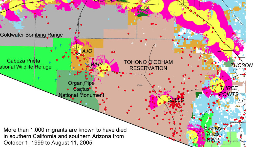
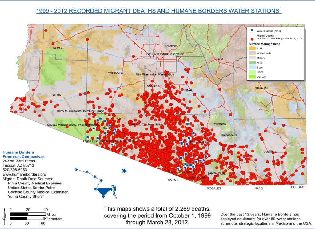
The exact distribution Snow organized contrast to the terrifying distributions of the deaths of migrants seeking passage across the border, which resists any extraction of an explanatory framework or conclusion, but raises questions about the inhumanity of the terrain we have created.
Dot maps of migrant deaths follow no such clear distribution, and has no sense of transmission form a single site. It forces us to acknowledge the deep problems of the criminalization of immigration on the Mexican-US frontier by charging its human costs. The sites of mortality from hunger and thirst are tragically dispersed over a far great undefined space, but embody the human costs of existing border policy, even a decade before Donald J. Trump used the management of the southwestern border as a campaign talking point to pole vault into public politics.
No similar diagrams can be drawn to elucidate the range of dead bodies discovered in the desert of migrants who were attempting transit into the United States for better homes: can one better explain their deaths b a virtual miasma of cruelty that fills the air of the border zone. Their deaths were caused by dehydration and starvation, as well as cold, but suggest nothing so much as a miasma of neglect. The distribution of deaths of migrants in the Organ Pipe Cactus National Monument, adjacent Cabeza Prieta National Wildlife Reserve, and O’Odham Reservation already illustrated a dereliction of national responsibilities.
The map is a deeply tragic reminder of the loss of life that is forgotten in the dry expanses of these deserts where the border, such as it is, lies, and the distinctly disturbing regime of a lack of interest or care for human fate that—even with the mortality of children in detention camps at the border—still can stretch incredulity at the evidence it offers of a large theater of cruelty. They recall the denial of burial to the bodies of enemies in the ancient world, left as prey to dogs and vultures: the Enlightenment jurist Giambattista Vico faced considerable difficulty explaining to his readers that there was a time when the bodies of anyone was left unburied in an earlier age in his Scienza Nuova, “an inhuman custom—so contrary to what the writers on natural law of all people’s claim to have been practiced among any nation— . . . which [once] prevailed among the barbarous peoples of Ancient Greece,” described in Homer’s Iliad, and at which he marveled as “crude, coarse, wild, savage, volatile, unreasonable and unreasonably obstinate . . . and foolish unreasonable customs,” far removed from his own age and from the imagination of his readers, so “discordant” was it with our own civil age. Yet the unburied dead whose bodies have been located in states of extreme decomposition along this border zone reveal a discordant reminder of the return of such an inhuman custom on the borders—and within the borders—of what we consider is a region that is distinguished and administered by civil laws. Whether this region can be rightly considered a region of lawfulness or civility seems to be raised and put on the front burner by the discovery and attempted identification of the human remains discovered lying in the desert, often dramatically decomposed, of migrants’ bodies dating from the administration of George W. Bush.
If Vico could scarce imagine the barbarity of leaving bodies exposed to the elements even in war—and the spectacular cruelty of the dragging of the body of Hector around the perimeter of Troy three times—among those who “were held to have spread humanity across the world,” given the sheer physical disgust of leaving the body unburied, and given that “all gentle nations certainly concur that souls [of the unburied] remain restlessly on earth, wandering around their buried bodies,” from Guinea to Peru to Mexico to Virginia to New England to Siam, the readiness of Christians to leave the dead unburied by the border, if not intentionally, haunts the border region with its own inhumanity. The violence of this early heroic age was before the age of laws of nations, for Vico, and belonged to the age of “violent and impious men who dared to enter the cultivated fields [] in pursuit of the weak who had fled thither to escape them,” and belonged to “the vulgar customs of the barbarous Greece” of Homer’s day, and adequate burial in fact constituted one of the three institutions of human society—with marriage and religion—in ways that betray the huge remove of a heroic era, which incredibly lacked burial customs or rites, from our own.
Yet the abandonment of unburied bodies has returned in the no-man’s land of the US-Mexico borderland, where the abandoned bodies of would-be migrants fall between governing bodies and accepted customs. Migrants that were stopped during the course of their attempts to reach a new life in the US were clustered at a distance from the border but reveal the amazing distances many undocumented migrants travel before they collapse, without food, and most often out thirst and dehydration–leaving them exposed as “prey to dogs and vultures” in the very horrifying ways that Vico was so horrified. The recent spatial distribution of such abandoned cadavers and corpses, left without any rites of burial, force the viewer to scrutinize its mute surface of dots against a deceptively pastel base map as if they might magically be able to glean or recuperate the silent, forever-lost stories of migrants who lost their lives attempting to cross the border, and the stories of whose travails and travels can never be told. The ends of their lives, reduced to the finality of a bright red circular dot in the data visualization, out of scale, arrests attention but is disarmingly and alarmingly flat, resistant to any further narrative or even identifiable name. Over 2,000 dead migrants whose bodies were retrieved at a significant distance from the border suggest their desperation to make their way across the border by clandestine routes, and the extreme climactic difficulties that they face, with few adequate provisions for crossing deserts whose expanse they feel forced to travel to search for jobs–risking their lives to do so.
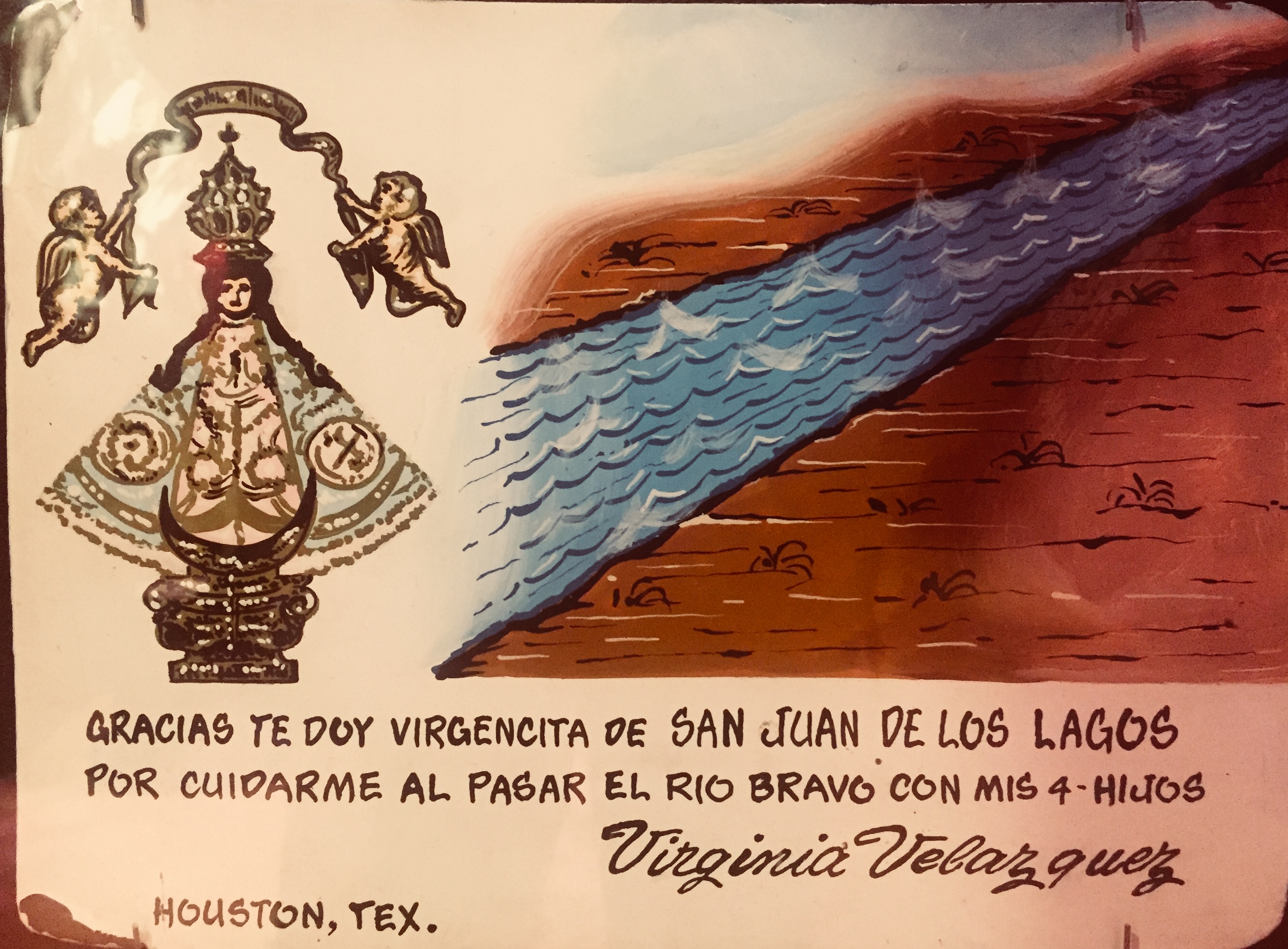
Ex Voto painted to express thanks forsuccessful crossing of the Rio Grande
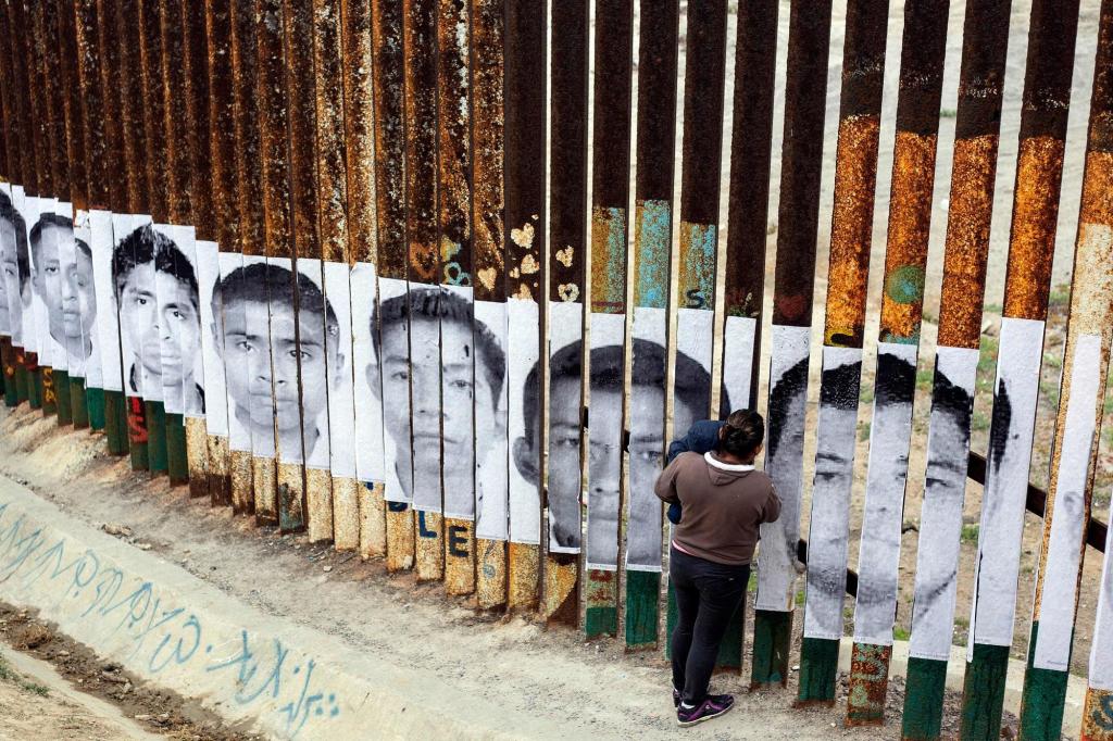
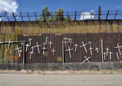
If the many migrant deaths of those attempting to cross the border between the United States and Mexico are often expressed by crosses that are hung on sections of the fragmentary “border wall,”—
—the precise distribution of the dead in sites of their death is rarely preserved in public memory, and the archive of dead migrants who did not survive passage is rarely assembled as a geospatial record.
The number of the dead remains but a fraction of those who have actually died attempting to travel north, leaving detritus and lost objects in their wake that only beg deciphering as images. For although their overlap suggest something like a clustering that might belong to an external infective agent, the alarming nature of the red points call attention to the human costs–and the anonymity of lives lost–that are the victims of the intense dangers of border-crossing that migrants accept and undergo, who we have forced to accept and risks of dehydration, heat stroke, hyperthermia, and starvation which have killed them.
If the deaths of those attempting to cross the border will probably never be know with precision—and is often lost to oblivion—the recovery of human remains affords a grim picture of the actuality of recovering the dead, and the attempts to name, identify, commemorate and memorialize their fates as well as prevent the loss of their identities, despite the jarringly abstract geospatial symbology of this map, and the minuscule proportion of those remained that have been so far identified.
This project of memory and memorialization, echoing the imagery of northward passage in the famous Underground Railroad taken by fugitive slaves taught to recognize the handle of the Big Dipper to follow the North Star to find their path to freedom, “Follow the Drinking Gourd,” the symbol of the constellation has been adopted by the Humane Borders organization which has identified remains and sought to allow them offer needed geospatial assistance to migrants in their search to find a path north.
We read more maps than ever before, and rely on maps to process and embody information that seems increasingly intangible by nature. But we define coherence in maps all too readily, without the skepticism that might be offered by an ethics of reading maps that we all to readily consult and devour. Paradoxically, the map, which long established a centering means to understand geographical information, has become regarded uncritically. As we rely on maps to organize our changing relation to space, do we need to be more conscious of how they preset information? While it is meant to be entertaining, this blog examines the construction of map as an argument, and proposition, to explore what the ethics of mapping might be. It's a labor of love; any support readers can offer is appreciated!


 CalaisEdinburgh (January 11, 2016)
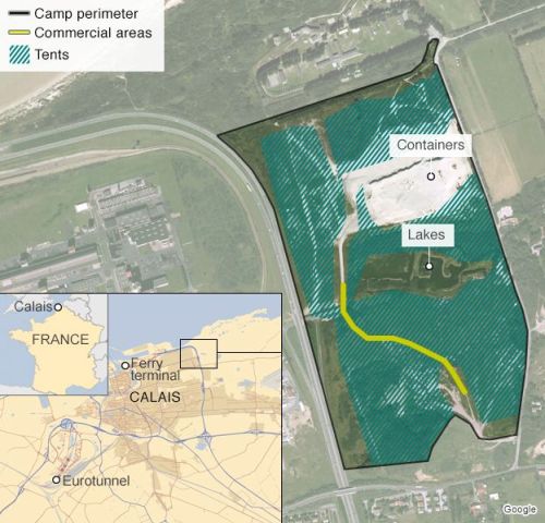
 INFOGRAPHIE. L’explosion du nombre de migrants à Calais en un graphique (2016)


