Syria, for now, remains on the map. But in the course of over two years civil war aged across Syria, the government of Bashar al-Assad has stock-piled chemical weapons as a last line of security in multiple sites. President Barack Obama’s administration has made use of chemical weapons against Syria’s population a justification for military attacks against or intervention in the country. But the prominence given to drawing this “red line” on the use of such weapons neglects to assess the pragmatic results of any intervention, and the nature of what form on-the-ground intervention in the relatively shifting state would take–or what ends such military actions would be able to serve.
The direction of the situation is not good, to be sure. The number of Syrians reported killed, abducted, gassed, or poisoned during the civil war over the past two and a half years, tabulated by Syriatracker, clearly centers the focus of violence around its capital city, Damascus, and is probably vastly under-reported:
![]()
The on-the ground situation is more complex than this map of reported violence: especially if one looks at the disparate groups that have independently continued (or sustained) the ongoing rebellion against the Syrian government, or, even more strikingly, at the huge number of internally displaced Syrians, a number greater than anywhere else in the world; and the number of Internally Displaced People is difficult to count; estimates are 4.25 million–almost 1 in 5 Syrians. The consequences of this displacement are impossible to map.
The situation on the ground has provoked this displacement through the fragmenting of the Rebellion into multiple fronts. An important and informative interactive Al Jazeera map of groups in the Syrian rebellion provides a far more complex measure of divisions among rebellious groups that have attracted different financial and military backing to overthrow Assad also challenging to map: rebels on different fronts include the large Northern Front near Damascus to Aleppo Front, Idlib Front, and Eastern Front, some in uneasy relations to one another, and is worth examining in depth at its website, in order to understand the mosaic of divisions in a landscape whose sectors are often pointlessly divided between “rebel-held” and those where Assad is dominant:
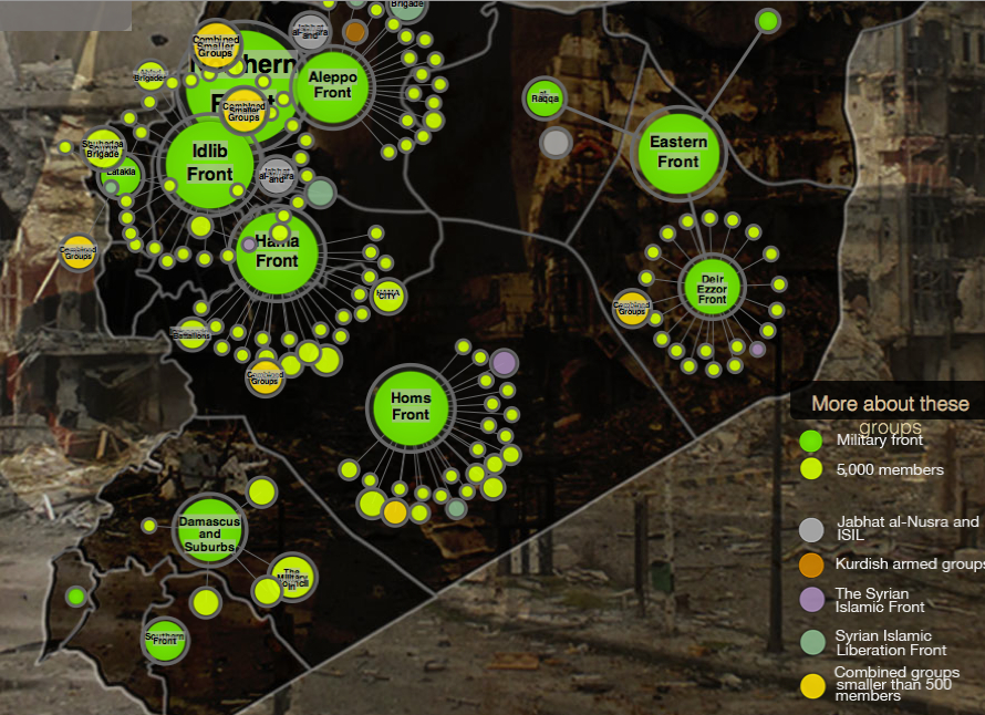
The above image of the fragmented nature of local control, and the independence of each group from one another, suggests the difficulty of defining a clear point of entrance and reveals the nature of ‘proxy war’ that has expanded over two years since the Arab spring, as the response to the Arab Spring of April 2011 that challenged the Assad dictatorship were almost randomly attacked by a violent militaristic security forces that echoed the violent tactics of Bashar’s father, firing live bullets into crowds of protestors and unarmed civilians, killing many innocent children, in acts of carnage and terror documented by Human Rights Watch as killing 587 civilians and over 250 children that emulated the theatrical mass-assassinations orchestrated against Syrians by his father, Haifez al-Assad. The repressive violence of these events, before civil war, increased the range of foreign bankrolling independent factions of rebellion, which is misleadingly cast as uniform by a map of anti-government forces as the below two-color map devised for Max Fisher of the Washington Post, which borders on intentional political disinformation:
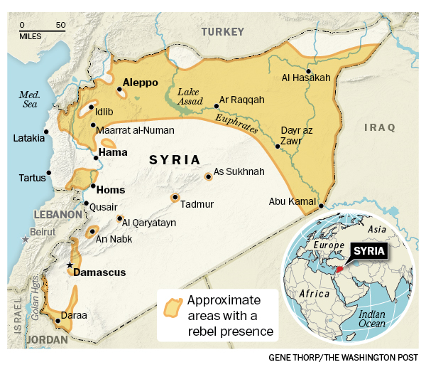
Despite using a uniform color to denote “rebel presence” as a single, uniform beige to mask divisions within “rebel presence” and the numerous individual deals that the Assad regime might make within them–and mask the actual of what David Brooks and others correctly identify as a “proxy war” between Russian planes flying from Iran over the nation, Hezbollah present in Syria, and with multiple “combustion point for further waves of violence.” The war is, in fact, not properly “civil” at all, so much as a broader war for the realignment of Middle East politics–and despite the attempts of previous administrations to involve rebel groups within the negotiation, the readiness with which the Trump administration seems more ready to strike–or threaten to strike?–from the eastern Mediterranean, Persian Gulf, and Red Sea–with less attention to the ethnic composition of Syria, than its own show of strength.
We have been particularly ill-served to understand the nature of this “proxy war” by the reductionist attempt to map ethnic diversities in Syria as if they revealed an internal fragmentation of a nation that is being driven apart by exterior forces. Such a map implies that the many sectarian divisions masked by the creation of the Syria’s borders account for instabilities among rebel groups, as if they are inherent in a multi-ethnic state as an amalgam of faiths destined to implode, regardless of the brutality of the two generations of the Assad regime:
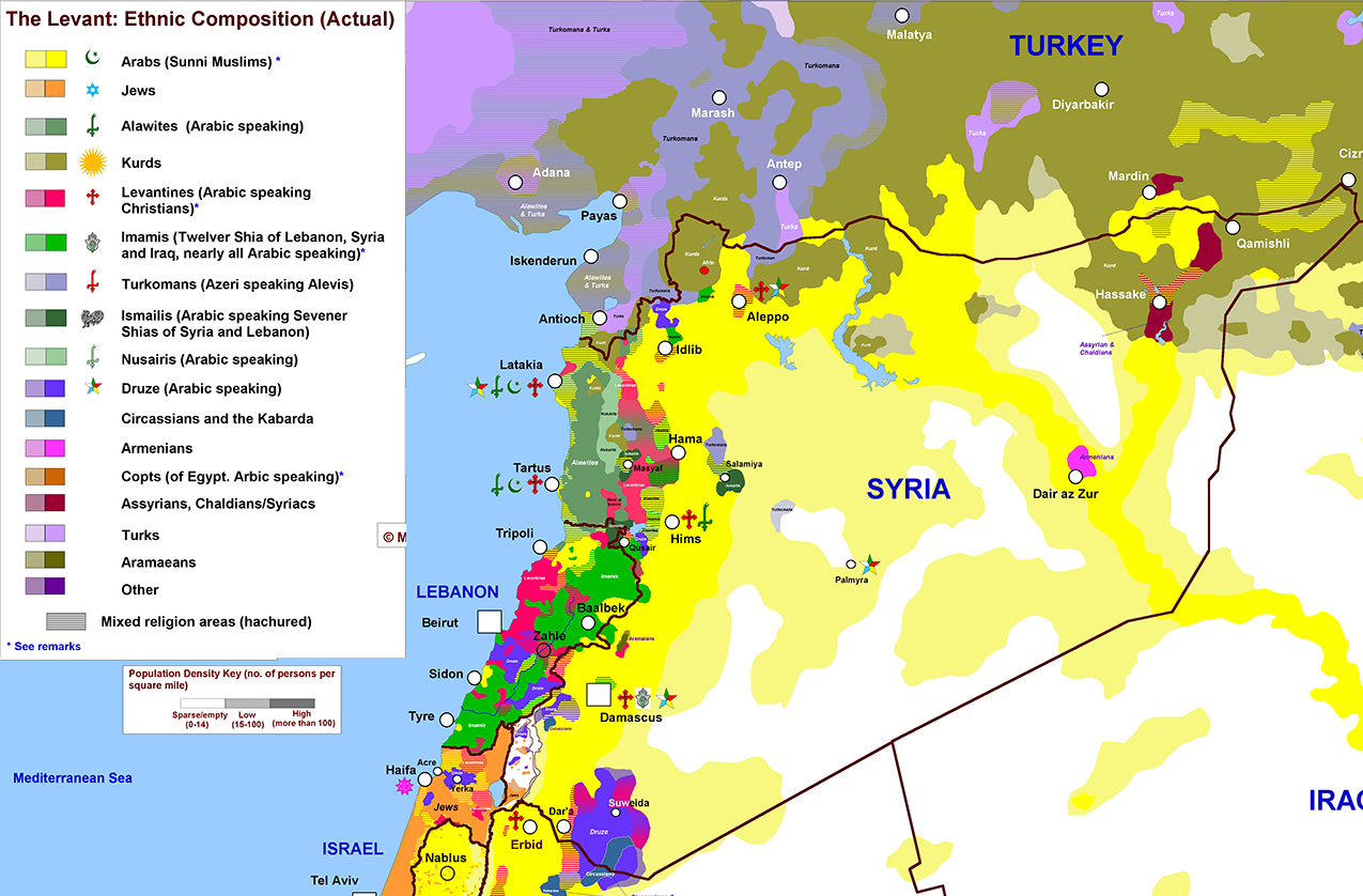
Yet the divided nature of the country lies in part in the improvised nature of resistance to a totalitarian regime, and the culture of violence that has been normalized within the Assad regime and within Assad’s security forces–the notorious Air Force Intelligence (إدارة المخابرات الجوية), whose ties to chemical weaponry have been substantiated in the recent past.
The drawing of stark divisions between areas controlled by different fronts and subject to government control obscure the near impossibility of drawing these lines of distinction along clear territorial boundary lines–and prepare a deceptively simple image of Syria’s future. One BBC news-map helpfully re-dimensions the local conflict, mapping government positions toward the coast and eastern cities, around holdouts and temporary redoubts of rebel resistance–although clear mapping of their division is difficult given the shifting landscape of alliances and lines of territorial defence among highly mobile guerrilla forces, who often tactically withdraw, rather than face military engagement, but can’t map the shifting lines of opposition or control–or the relations between the fronts that are themselves supported by different constituencies in a patchwork of strongholds:
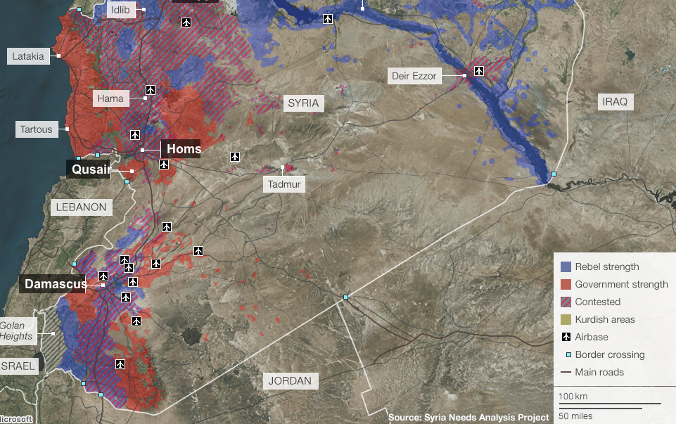 BBC/Syria Needs Analysis Project
The map poses deep questions of what intervention would mean without a clear map even available to be read. They also reveal how much the debate about war is being waged not only in words, but maps. The focus of global attention is not only on the violence that has divided the country for over two years, to be sure, or the humanitarian disasters created by the many refugee camps on Syria’s borders, but allegations of the use of chemical weapons. Yet the mapping of Syria’s disasters and composition are central to any discussion of military intervention.
And we now have a map of where strikes might be directed against air force bases and sites of chemical production, courtesy Foreign Policy magazine, which uses a Google Maps template to mark the storehouses of potential chemical factories and air bases targeted as primary sites of missile attack:
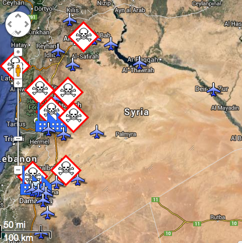
What sort of a vision of Syria as a country does it describe? The visually striking deployment of skulls-and-crossbones icons to designate locations of plants that produce chemical weapons is scary, and so much so that it almost evokes incursions by pirates along the Mediterranean coast–as much as sites of chemical weapons. (Of course, such sites would not in themselves be targeted, but the decision to avoid them depends on the accuracy of military intelligence; the decision to target all pharmaceutical factories also poses a future crisis for already over-crowded Syrian hospitals.) But it suggests a rather blunt map of the notion of military intervention, and reveals the difficulty of projecting a limited surgical strike against selective sites that are removed from the Syrian population.
In the light of the relative military success of the long-distance bombing strikes into Algeria, it seems tempting and morally compelling option to end the violence and self-evident terror of gas attacks by unseating the Assad tyranny, or by providing Syria with a clear warning–although what it would warn we are not sure–against purposefully deploying chemical agents against its citizens.
The map raises many questions by marking so many facilities along Syria’s Mediterranean coast. It makes one wonder how such a map became so easy to reconstruct–and the wisdom of allowing such a plan of attack to be rendered public on the internet. For the map suggests that strikes can be easily launched, in a sort of war conducted from aircraft carriers at a distance against Iran’s close ally, firing Tomahawk cruise missiles at them from American warships moved to the eastern Mediterranean–although it’s relatively easy construction has led many to openly wonder why such a detailed range of options would be publicly leaked by the White House in such detail, even indicating the targets of a strike of one to two days against fifty specific sites. (Reuters found redeployment of many key army, air force, and security headquarters buildings in central Damascus that might attract U.S. cruise missiles, and poison storehouses, if not sites of production, could be moved.) Would it be worth the potential danger of hitting a storehouse of sarin or FX?
Targeting chemical factories, moreover, does not address the likely existence of available chemical arms–although attacks render their release more likely. Every chemical plant is not the producer of sarin and mustard gas. In imagining the raids on the air-bases and potential sites of chemical weapons, the map takes advantage of a registry compiled by the Nuclear Threat Initiative locating where weapons are either manufactured or stored. Yet despite the offensiveness of chemical gasses, their repellent nature, and their close historical association with threats or attacks of terrorism, what sort of counter-attack on the Syrian population the government would unleash as a response to the attack is not clear. The attempt to paralyze Syrian aircraft who might attempt to deliver them seems worthy, but the bombing of potential plants risky at best. Bombing sites of chemical production doesn’t sound like that great an idea after all, however, since this would most likely disperse the very gasses that they contain–with more dangerous effects than the uses of Sarin or FX against the Syrian population–if such targeting would of course not be intentional.
The incommensurable relation between an air-raid or selective missile strike with storage-sites of chemical weapons has led several to question the value of such attacks, even after knowledge that the government may have intentionally used poison gas against its own citizens. There is a small likelihood of eradicating more than a small portion of stockpiled chemical weapons in the country, since, unlike biological weapons, most probably will only be widely dispersed by such a blast–and conceivably hurt civilians as they more widely and rapidly disperse, considerably raising the bar for “collateral damage.”
How any such sort of attack will change “action on the ground”–and the questions of what military strike can alter the humanitarian and moral disaster that Syria has already become–remind us of the pressing need to have a clearer map of the action on the ground than a Google Map can reveal, as we examine consequences of a “limited air strike” beyond the hope to cripple the Syrian airforce or discourage the terrifying possibility of further use of poisonous gas against an opposition–and ask if a “limited air strike” is possible in this complex geopolitical microclimate.
Lastly, the mapping of clear targets and divisions within Syria’s boundaries obscures a hidden–but important–map of refugees on the borders of the country. As well as having internally displaced millions, the fragmentation of fronts in the country have created a growing humanitarian crisis in camps on Syria’s borders, and the 3.5 million refugees who are estimated to leave the country by the end of 2013 for neighboring regions, further fragmenting and dispersing the country’s population:
Color-coded according to the largest number of Syrian refugees received in each country, we range from deep purple in Lebanon (more than half a million refugees dwell), and just less than half a million are in Jordan and Turkey, and smaller numbers in Iraq and Egypt – 161,879 and 75,456. This alternative geopolitical map serves as a negative view of the strategic relations between he nations. It also poses a problem of how each of these countries respond to the crisis: such a data-visualization fails to render the different immediate challenges of each refugee family, their poverty, and their amassing on the borders of each region, rather than throughout the country. For this is a humanitarian disaster waiting to be mapped.
Given the difficulty in mapping the multiple divisions within the country into rebel and government forces, and the crises of internal and external displacement of Syria’s population, we must resist seeing mapping clear targets of attack. The maps of clear divisions in the country as a clear opposition of forces are distorting filters that are more distracting than they are informative, with overly neat and tidy boundary lines. The complex conflicting rebel factions supported by backers, and the sort of power vacuum that would be created by significant and serious destablization of the country or desperate responses (or the shifting of responsibility) that strikes against the country’s remaining inhabitants might trigger.
Syria’s conflict of course exists not only as a map of frontiers and inhabitants. Worldwide, it should be remembered, there remains significant opposition to military intervention, charted by Mona Chalabi and Charlotte Henry in the The Guardian’s datablog–not only because of longstanding alliances between Iran and Syria, or Syria and Russia, but exceedingly complex questions of what ends intervention would accomplish–and what outcomes it would produce, as well as how it would be sustained.
Viewing the conflict in Syria not only through the lenses of national alliances, but by what can be best mapped on the ground, must become more central to US foreign policy objectives. We cannot “chastise” or “wound” the Assad regime without realizing that we may wound the country, or erase it from the map.
All too easily, from the point of the United States, at least, we risk viewing the conflict either too much on the micro level, or at a remove of the capacity of bomb strikes, paying far less attention to the delicate nature of the situation on the ground. Indeed, the faux apocalyptic tenor of some maps of imminent war that is tragically advanced by right-wing bloggers, that strip the power of cruise missile strikes from their context–

–suggests a removed image of the ability to launch air strikes against a nation at a remove from the ground, and an ability to “target” strikes–the illusion of GPS–at a single dot, without registering the huge impact such strikes would have on a country and is inhabitants. In an era of shooting first and asking questions later, by 2017 we use maps to fire from the hundred and five missiles on Assad’s “chemical weapons facilities” as “surgical strikes” by tools able to pinpoint chemical weapons storage and research facilities outside Syrian cities, as if they have a fixed non-human target to eliminate.
 Targeting of Syrian Capital on April 14, 2018/Hassan Ammar/API
Can the promise of mapping with such precision inflate a sense of the ability to intervene from a remove, targeting targets outside Damascus as the Barzah Research and Development Center, or the Him Shinshar complex outside Homs, without terrorizing the Presidential Palace, and without worrying that such armed interventions will not eventually escalate, as they dramatically change the experience on the ground?