Tag Archives: Bashar al-Assad

Finding Aleppo in a War-Torn World

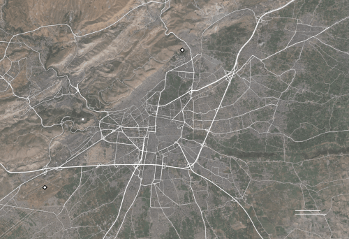
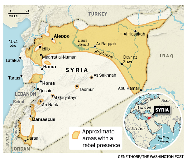
The deep frustration at being able to map the Syrian civil war around Aleppo–combining the actual inability to map the factions in the conflict, and the actual unmappability of the deeply unsettling destabilization of civil society in the five-year civil war which is waged by outside actors, as much as by the Syrian government–has sapped confidence in the ability to negotiate a cease-fire or indeed to find a civil solution to a conflict that has both created an ongoing flow of refugees and destroyed civil society in the region, as well as an equilibrium of power.  And the more we are frustrated in being unable to map the conflict and its descent into inhumane violence, the more violent it has become and the farther removed from being able to exist again as a country.


blog-8


Any theater of war is extremely difficult to endow with coherence in a map–one speaks of the “fog of war” to describe the clouded experience in the confusion of military conflicts.  But the difficulty of gaining purchase on the extent of the destruction of the ancient city of Aleppo that is particularly troubling–and troublingly matched by the difficulty of mapping or imagining the targeting of the city and Aleppo’s inhabitants and the refugees who have left the city.  The failure to describe, document, or respond to the costs in the sustained aerial bombardment in recent months seems an abdication of ethical responsibility before such escalated destruction that almost fails to acknowledge its scope.  The terror of aerial strikes against civilians have led to the targeted destruction of schools and hospitals in the rebel-occupied regions of the city hard to imagine, as a besieged city is isolated from the world.  While we don’t have access to the maps and plans that were used during the sustained engagement of rebel forces in Aleppo, and have rather watched screen-shots of the diminishing areas of the region “held” by “rebel forces” over months, those very images distance us from the human rights tragedies that is occurring on the ground with the dismantling of public health care and social institutions, as if extending so many false possibilities of the tenuous grasp over territory of opposition groups.  With unclear data on suffering, deaths, refugees or destroyed buildings in the encircled city, we map territory as the clearest index of the balance of war, but ignore the scale or scope of its ongoing bombardment and destruction, as the country has not only “gone dark”–


–but the city destroyed under unimaginable sustained assault.


aleppo-sept-2012


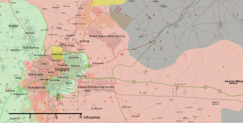
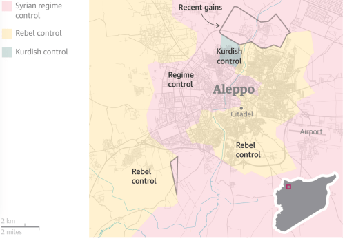
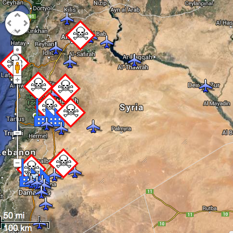
News wire sources have tried to “map” the extent of those lines areas held in the heavily bombed city, to be sure, in recent months.  But the absence of clear lines of jurisdiction or control of a battle that is increasingly waged from a move–but shown as if it were a land war–echoes the military divisions of cities in ways that seem incommensurate with the suffering or mischaracterization of the actors of the war, and the lack of limits with which the Assad regime has enlisted foreign help to destroy its former cultural capital and economic hub, as if trying to efface the opposition that it has for so long successfully tarred by their association to ISIS and the Islamic State–and as a media blitz has tried to portray the battle in Aleppo as a fight against ISIS rather than a defining moment in the escalation of military forces against one’s own people by Bashar al-Assad.

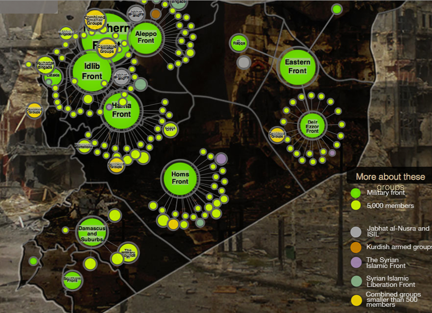
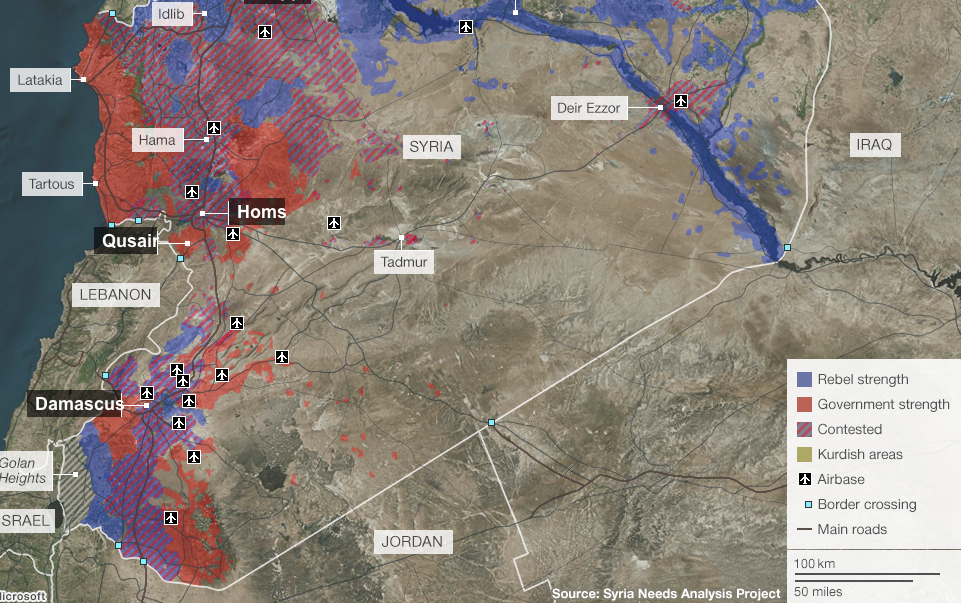
Even though the aerial attacks on Aleppo began as early as July 2012, the escalation of attacks by Russian bombers that began to target buildings and humanitarian supplies with intensity from July 2016.  While we were in the midst of the farce of our recent American Presidential election, we have watched maps of the Syrian conflict at an odd remove, depicting the city the city as a multi-colored sectored region, as if a point of stasis in slippy map of sovereignty, as much as a focal point where five different forces seem to lock horns.  The disservice of these opaque colors seem to erase and to be done such a deep disservice with Microsoft Paint.  And as we do so, we can only fail in an attempt to chart the intensification of suffering that is only like to increase in coming months, as the shrinking green lands held by rebel forces have depicted the so-called “situation in Syria” in increasingly disembodied fashion.


syria97410fps.gifThomas Van Linge/Newsweek/@arabthomness


As we watch the layers of colors, trying to map the levels of conflict from an empyrean remove that has echoed the official policy of not putting “boots on the ground,” we fail to account for the destruction of houses, massive departures of residents, targeting of humanitarian assistance and destroyed infrastructure and human services in the city.  The layers with which we discriminate a war-torn city set to conceal terrifying human costs in the rather terrifying palette of pastels in its curious camouflage, as if to hold out hope for an amicable solution, but to erase the destruction of civilian lives, hospitals, residences, or food and needs supplies that tried to arrive in the light green rebel-held areas of the city that suggest an island around the Citadel of Aleppo.


Rif_Aleppo2.svg.pngNovember 1, 2016/Kami888


For the limited information about Aleppo’s continued destruction by aerial attacks as well as bombardments makes the extent of the human costs its destruction increasingly difficult to render with coherence.  This absence of this coherence perhaps leadt some twenty-nine million to be struck by viewing the dazed five-year old Omran Daqneesh and the tragically bloodstained face from which he gazes somewhat stoically and looks at his bloodied hand–as if dazed to be transported from the scenario of violence in which he lived to what seems a setting of sanitized medical care, his blood-stained face contrasting to the clean orange cushions of an emergency ambulance.  The transferal of Omran from the battlefield like context of Aleppo to the emergency health care vehicle show him dazed not only at his change of context, but almost in shock of being in a controlled ambulance in which he sits, if a sign of hope, is also emblematic of the inability or difficulty to bridge the controlled context of medical and clinical care of the Emergency Medical Services and the rubble of the besieged city, almost the negative image of a controlled environment:  the image circulated by Aleppo Media Centre was emblematic of the dissonance between the emergency services and the onslaught of bombs where civilians are targeted daily amidst the rubble of the besieged city, so that the dazed look of poor Omran seems a substitute for our own helpless bewilderment at the war crime of the sustained aerial bombing of Aleppo’s buildings, health care providers, hospitals, and inhabitants.


Screen Shot 2016-11-21 at 11.36.14 AM.png


If the image is manipulative–and difficult to include in yet another post on Aleppo–its power seems to derive from the failure we feel between inability of the child who touches his hand to his head, to take stock of his head injury as he tries to process the loss of his family, after being carried by an emergency worker into the new setting of an ambulance.   The image was so poignant it was shared so widely all over the world on Facebook, as we searched collectively for an emblem of good, of one child rescued from the violence of Aleppo–as nine million Facebook users tried to transcend the broken windows, destroyed buildings, and slim hopes for the survival of Aleppo’s citizens, increasingly targeted in inhumane ways to which we are so unable to respond.

For if there is a lack of any coherent purchase on the city’s destruction on such an unprecedented scale of its bombardment, even for the Syrian Civil War, the saving of one child after his family was lost allowed the survival of a child to exist in the blood-streaked face of the five-year-old Omran Daqneesh that circulated globally on social media seemed finally to locate a “face of the Syrian Civil War” against the city’s dire destruction.  Indeed, the actual improvised settings of health care in eastern Aleppo–


624143740-graphic-content-wounded-syrians-are-seen-on-a-table-in_1-jpg-crop-promo-xlarge2Thaer Mohammed/AFP/Getty Images


–continued as bombs continued to strike the neighborhoods and where the living and dead lay beside one another in emergency rooms that lacked adequate medical supplies.  The absence of medical assistance or facilities, even as Bashar al Assad rejects the last proposal proposed by the United Nations for a local truce that recognized any claims to separate sovereignty of rebel forces, if it was not armed, arguing that it was a violation of “national sovereignty,” seems to have invited an endgame of increased military raids, as the “area held by rebel forces” has shrunk in recent days to a small region curving around the medieval fortified Citadel, sandwiched between advancing regime forces.


nov-1-aleppo


The garishly bloodied face of Omran, the sole survivor of an air strike on his family home in Aleppo’s rebel -held territories, seemed a ghost, but served as a respite from images of the dead, and his transport to an ambulance from the horror of Aleppo seemed a promise of the future.  The image posted by the Aleppo Media Center provided little orientation to the actual struggle, but the apparent shock of the contrast of Omram’s evident transport, his face and T-shirt covered in dirt and blood, to safety offered more than a reprieve from image of dead children:  seated in an ambulance, fingering his bloodied head, his place provided a bizarre juxtaposition of a world of safety and medical supplies who had moved from the bombing of his family’s building in a war-torn city we can barely map.  The arrival of the child into a setting of Western safety almost seemed an image of the precareity of saving a child out of its destruction, and preserved an odd ability of hope even as airstrikes would soon hit four hospitals in east Aleppo, and continue to target civilians.

Continue reading

4 Comments

Filed under Aleppo, data overlays, human rights, Syrian Civil War, Syrian Free Army

Palmyra in the World and on the World Wide Web


The long-fears impending destruction of Palmyra, not “just another town on the map,” says the NBC Nightly News, but a site for “erasing history” has been identified as an epicenter of the feared project of cultural genocide of opulent archeological remains–as well as of actual human deaths.  After the Islamic State published photographs of the destruction of the World Heritage Site, the recent damage assessment of the city recovered by Syrian forces suggests the preservation of some 80% of ruins, and despite the reduction of several 2,000 year old temples to rubble, after Syrian Army jets helped retake the ancient city.  Yet the episode suggested the horror of the loss of ancient fragments that ISIS seems to have decided, with good judgement, to preserve, including its Roman amphitheater, despite the apparent destruction of its elegant Triumphal Arch.


a803e625f7974f0088070dd4f790b86c_18


The concentration of destruction of sites that were deemed to be of cultic value–as the  Temple of Baalshamin or semitic Temple of Baal, or statues of Athena–seen as heretical, while benefitting from media attention to the survival of ruins to treat them as hostages.  But the city offered a stage for conductive provocative assaults,


arch-after.jpg
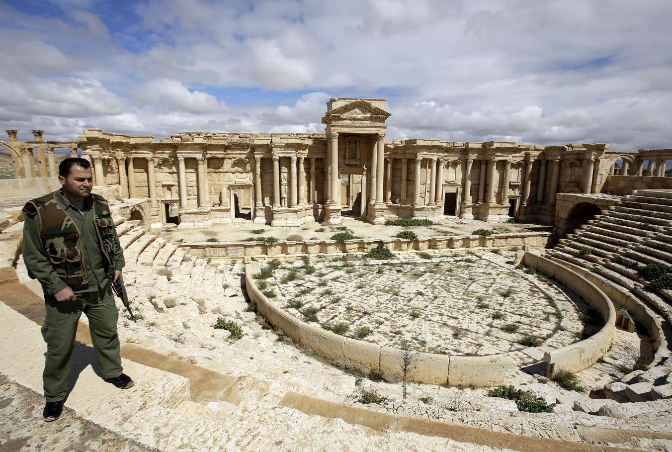
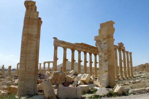
Maher Al Mounes/Agence France-Presse/Getty Images, March 27, 2016


Many objects were, of course, sold on the black market to raise needed funds.

The longstanding difficulties of securing artifacts from smugglers from ceramics to bronze lamps to mosaics illustrating Homer’s Odyssey to medieval illuminations of the Quran, to the destruction of actual minarets, souks, and entire sites of archeological excavation.  David Brook’s claim that ISIS has created a wormhole of history that has transported us to a “different moral epoch” as much as a different political landscape, utterly removed from the moral codes he has recently celebrated, affords a prime spot to the destruction of archeological treasures.  As much as introduce a “wormhole”–a space-time passageway, theorized by Einstein and Rosen as a theoretical “bridge” that jumped huge distances that connect distances of billions of light years, the topography of Palmyra’s ruins offer something of a historical echo chamber as the fears of the disturbance of its awesome ruins were relayed across the world wide web, as well as an act of unpardonable criminal destruction.

la-fg-palmyra-temple-destruction-pictures-2015-014

AFP/Getty Images

The fears of losing such cultural monuments may reflect deep uncertainties in the possibilities of devoting military forces to protect physical objects from looting and destruction–and to continue to guard them in the face of military–but also reflect the scorched earth policy that the Assad regime has adopted in relation to its own lands.  And months after Syrian forces assured the world of the security of Palmyra’s ruins and of the city’s surrounding hills in mid-May 2015, the late-August announcement that explosives have demolished the Baalshamin Temple, a site to worship the Phoenician god of fertilizing rains which once stood some five hundred meters from the city’s amphitheater, has realized deep fears of cultural destruction and become emblematic of the extreme fragility of one’s relation to a historical past.  The site, long emblematic of a material presence of the ancient world in the wilds of the Syrian sands, became a theater for the destruction of antiquities, and even of the beheading of an eighty-two year old scholar of antiquities, Khaled al-Assad, whose executed body was strung up and suspended as an object-lesson.  The report that the Islamic State purposefully planted explosives in the city’s monumental ruins–“western” ruins in addition to the Assyrian monuments in Nimrud–and the recent images of explosives at the Temple of Baalshamin–offers grounds for the realization of fears to the pledge of an unidentified militant that “whenever we seize a piece of land, we will remove signs of idolatry and spread monotheism.”

la-syrian-archeologist-who-protected-palmyra-r-001

Khaled al-Assad

Although the capture of the city may have been more closely tied in the mental geography of ISIL figures to Tadmur prison‘s destruction, a site of arbitrary and inhumane detention from the 1970s–“High walls of cold cement/ Control towers/ Mine fields/ Check points/ Barricades and special military forces/Finally… A space of pure patriotic fear,” wrote the poet Faraj Bayrakdar, who had been imprisoned there for some six years, “If the whole of Syria falls/ This prison will never ever fall.”  But the French-buiilt prison, fashioned as a panopticon in true Benthamite style, was the in the 1930s in the desert, site of a massive slaughter of members of the Muslim Brotherhood by Hafaz al-Assad’s henchmen and of sanctioned beatings and whippings, whose interiors were first broadcast by the ISIL as they recaptured the site and before they had destroyed it, were almost emblematic of the crimes against humanity of the current regime’s predecessor.

_83750064_cells-grey

The attention to this site of fear and horror were quickly shifted, however, to the fears of the destruction of the city’s ancient amphitheater, which quickly became an arena of institutionalized violence for ISIL occupiers.

Such growing fears of expectations of destroying a Unesco World Heritage Site that would surely lead to a swift world-wide condemnation–as well as an offense against Syrian culture–were stoked by worldwide media, and must have partly led ISIS to release multimedia images that affirmed the preservation of cultural heritage that lies on the site of the Syrian-Iraq border to calm such accusations.  Even as the Director of Antiquities in Damascus has asserted that many treasures have been preemptively removed from the city, a counter-offensive by ISIS was adroitly waged on the world-wide web, as they posted images of intact ruins in the Syrian city–even as the humanitarian crisis in the area grew with air-strikes from the forces of Syrian strongman Bashar al-Assad.

8e565e9b-227f-4f36-a554-c68b6c8ccc76-1020x612

 Palmyra !

But the very images themselves conceal a bit of a debate about what a cultural heritage actually is:  as much as ISIS commander Abu Laith al-Saoudi somewhat convincingly assured Syrian audiences that his forces could commit to no violence against a cultural patrimony.  “Concerning the historical city, we will preserve it and it will not be damaged,” al-Saoudi clarified that his targets were idols, rather than architecture, as if to lend the veneer of a theological disputatio to their actions:  “what we will do is to pulverize statues that the miscreants used to pray for,” he clarified, but “as for the historical monuments, we will not touch them with our bulldozers as some tend to believe.”

Whether the Palmyran monuments would be considered part of Syria’s cultural patrimony or antique architecture is not clear, although the manner that the winged Assyrian bulls or horses constituted part of an Iraqi cultural patrimony–much as the ruins of Palmyra for Syrian–may be very tragically overlooked.

Winged Bulls

In asking what constitutes a historical monument and what a religious icon, al-Saoudi raises a cultural quagmire and a debate on iconoclasm all too familiar from the sixteenth-century Reformation if itself also inherited from the ancient world–even as he seeks to invest the destruction of a classical heritage with an aura of doctrinal debate.

But the possible preservation of many statues, if indeed taken to safekeeping before the invasion, has not led to any hesitation of using the backdrop of its second-century ancient Roman amphitheater to round up and execute at least twenty supporters of the Syrian state, according to the Syrian Observatory of Human Rights, and kill two hundred more.  What constitute the Palmyrene divinities–reliefs on funerary monuments? lions and eagles with open widespread wings? images on tombs?–is open to interpretation and will probably not be that closely overseen.  The monuments that have remained less vulnerable to air bombardment, weather damage, acid rains, suggest a vulnerability to the widespread but only recently recognized looting of antiquities that have slowly resurfaced on the black market, providing a source of income that has recently rivaled Syrian oil fields as a needed source of cash as other sources are drying up for ISIS–if we trust the record of financial transactions recently found on one of the flash drives of an ISIS commander, which detailed the sales of some $36 million of stolen ancient artifacts that were sold on the black market.

The recent specter of the destruction of tombs outside the city of Palmyra by explosives offered a taste, however, of the destruction that might be waiting to be unleashed.

81160.adapt.676.2Joseph Eid/AFP/Getty Images

Is it really true that, as the New York Times reports, the cultural vandalism of tombs and statutes–a destruction whose propagandistic value Amr Al-Azm of Shawnee State University compares to the choreographed beheadings of captives as designed to appeal to some ISIL supporters–occurred as a cautionary warning to nearby Syrian troops?  or a sign of their withdrawal from a region, and the acceleration of demolition in the face of military defeats?  The value of the Palmyran antiquities to ISIL, whose sales of antiquities from an Abyssinian monastery in Syria’s Nabek district totalled $36 million, must reveal canny knowledge of the calculus of their value as intact objects.  So many antiquities now stand guarded by Syria’s government that a list of Emergency Red List of Syrian Cultural Objects at Risk has been distributed to border guards, as many looters in ISIS have become amateur archeologists, and, until ISIS troops took the city, a guard was stationed at the amphitheater itself, as if to declare its worth to the state.

The release of some ten photos by the Islamic State showing the preservation of architectural ruins contrast to the familiar photos posted online in February of the destruction of antiquities in Mosul, but seems to be an attempt to repristine their image, despite the brutality of the executions, as Syria’s official news agency, SANA, released file photos of the city’s antiquities that were threatened with destruction, no doubt in an attempt to gain world attention as well as stoke nationalist sentiment as well as horror.  The place of antiquities is a delicate one within the propaganda forces that have mobilized behind the war, with ISIS using the destruction of antiquities as a bit of a rallying cry to supplement Jihad, long after it had actually destroyed substantial numbers of churches.

But if the value perceived in the destruction of antiquities may have been feared to make Palmyra something of a poster-child, the videos that successfully cast the ISIS trips as philistines for folks like Boris Johnson, the former mayor of London who confessed to be moved to future mobilization by the hopes to defend Assyrian Gods who sport “those curious ringleted beards in the shape of typewriters” and profiled horses, as if they were ready to suddenly sign up for fighting on the frront lines to defend the heritage, or at least give thanks for the oft-criticized custodial role London’s British Museum–which seems to have been Johnson’s real (and openly knee-jerk nationalist) point.

boris_3173691b

Telegraph

Although Barack Obama and the United States has not openly entered the conflict, the ongoing promises of continued military, economic, and diplomatic assistance has been poised behind the notion of joint Sunni-Shi’ite counteroffensives yet to materialize, but seemed to place us on the brink of war.  But Palmyra stands at more than the symbolic epicenter of the war, or as a strategic gain of the extent of “territory” that ISIS (or ISIL) can be said to “hold” as a cohort of alliances:  it is a benchwater of how rapidly the Islamic State has spread, and the rapidity with which the Syrian Free Army, without any credible external assistance, has been able to hold agains the two-fronted assault it faces from government and foreign troops, and its effective marginalization to the West.

May 2014-May 2015 Syria

The expansion of the congeries of ISIS/ISIL-held lands have effectively isolated a front in the northeast from the western fronts against which limited resistance remains, and Assad’s forces have proved to be little effective military resistance.

MAY 2015 SYRIA

In a sense, the ruins of Palmyra are enshrined as sources of material contact with the past in the landscape in the engravings from Robert Wood’s Ruins of Palmyra, otherwise Tadmor, in the Desart [sic] (London, 1753), based on the surveys taken by the architect and artist Giovanni Battista Borra, informed by Borra’s own close study of Vignola, which are again echoed in the visual composition of many of the images of the local ruins now feared to be facing destruction or destroyed in the global media.  Borra’s expertise in such neoclassical views had been honed, interestingly, in his own set of views of Turin, Vedute principali di Torino disegnate in prospettiva, as well as his views of Rome and Tivoli, which his dramatic elevated views of awesome intact colonnade and surrounding ruins echoed.

But Borra’s Palmyran views of Wood’s archeological sites gained an international appeal that provided immediately accessible memories of the elegance of the city’s ancient past and a repertory for neoclassicism.  And rather than a prison, their grandeur suggest the odd emptiness of Ozymandian ruins of past grandeur that his own architectural expertise allowed him to recognize.

PalmyraGiovanni Battista Borra, with Dawkins and WOod

Giovanni Battista Borra, Palmyra

Palmyran Colonnade

Special Collections, University of Washington Libraries

Borra’s majestic engravings are romantic, if oddly analytic in their silent statuesque melancholy.  They also evoke the tragic prospect of the loss of such sites, whether due to ISIS militia or possible future aerial bombardment of the region from Assad’s Syrian air force if not American troops.  While standing at quite considerable chronological remove, their silent beauty serves to underscore an enormous potential tragedy of looting a desert landscape of ancient architecture.

Palmyra ISIS #2

Jonathan Klein/AFP/Getty Images

All too often, however, we are apt to focus on the awe of monuments that have so long occupied the Western imagination–with a legacy this post has rather cursorily tried to map–rather than the humanitarian injustices of the continued displacement of human refugees in the ongoing Civil War, according to images released by Human Rights Watch this April, for which there seems no clear end in sight–especially along the so-called “demilitarized” border between Syria and Jordan.

April 20 Encampments and tent shelters on Jordanian border

1 Comment

Filed under ISIS, Islamic State, Syria, Syrian Civil War

Targeting Sites of Attack in Syria


Syria, for now, remains on the map.  But in the course of over two years civil war aged across Syria, the government of Bashar al-Assad has stock-piled chemical weapons as a last line of security in multiple sites.   President Barack Obama’s administration has made use of chemical weapons against Syria’s population a justification for military attacks against or intervention in the country.  But the prominence given to drawing this “red line” on the use of such weapons neglects to assess the pragmatic results of any intervention, and the nature of what form on-the-ground intervention in the relatively shifting state would take–or what ends such military actions would be able to serve.

The direction of the situation is not good, to be sure. The number of Syrians reported killed, abducted, gassed, or poisoned during the civil war over the past two and a half years, tabulated by Syriatracker, clearly centers the focus of violence around its capital city, Damascus, and is probably vastly under-reported:


Syria Tracker- Missing, Killed, Arrested

The on-the ground situation is more complex than this map of reported violence:  especially if one looks at the disparate groups that have independently continued (or sustained) the ongoing rebellion against the Syrian government, or, even more strikingly, at the huge number of internally displaced Syrians, a number greater than anywhere else in the world; and the  number of Internally Displaced People is difficult to count; estimates are 4.25 million–almost 1 in 5 Syrians.  The consequences of this displacement are impossible to map.


The situation on the ground has provoked this displacement through the fragmenting of the Rebellion into multiple fronts.    An important and informative interactive Al Jazeera map of groups in the Syrian rebellion provides a far more complex measure of divisions among rebellious groups that have attracted different financial and military backing to overthrow Assad also challenging to map:  rebels on different fronts include the large Northern Front near Damascus to Aleppo Front, Idlib Front, and Eastern Front, some in uneasy relations to one another, and is worth examining in depth at its website, in order to understand the mosaic of divisions in a landscape whose sectors are often pointlessly divided between “rebel-held” and those where Assad is dominant:

Mapping Interactive Map of Syrian Opposition
Al Jazeera English

The above image of the fragmented nature of local control, and the independence of each group from one another, suggests the difficulty of defining a clear point of entrance and reveals the nature of ‘proxy war’ that has expanded over two years since the Arab spring, as the response to the Arab Spring of April 2011 that challenged the Assad dictatorship were almost randomly attacked by a violent militaristic security forces that echoed the violent tactics of Bashar’s father, firing live bullets into crowds of protestors and unarmed civilians, killing many innocent children, in acts of carnage and terror documented by Human Rights Watch as killing 587 civilians and over 250 children that emulated the theatrical mass-assassinations orchestrated against Syrians by his father, Haifez al-Assad.  The repressive violence of these events, before civil war, increased the range of foreign bankrolling independent factions of rebellion, which is misleadingly cast as uniform by a map of anti-government forces as the below two-color map devised for Max Fisher of the Washington Post, which borders on intentional political disinformation:

syriaForMax-2


Despite using a uniform color to denote “rebel presence” as a single, uniform beige to mask divisions within “rebel presence” and the numerous individual deals that the Assad regime might make within them–and mask the actual of what David Brooks and others correctly identify as a “proxy war” between Russian planes flying from Iran over the nation, Hezbollah present in Syria, and with multiple “combustion point for further waves of violence.”   The war is, in fact, not properly “civil” at all, so much as a broader war for the realignment of Middle East politics–and despite the attempts of previous administrations to involve rebel groups within the negotiation, the readiness with which the Trump administration seems more ready to strike–or threaten to strike?–from the eastern Mediterranean, Persian Gulf, and Red Sea–with less attention to the ethnic composition of Syria, than its own show of strength.


image.png


We have been particularly ill-served to understand the nature of this “proxy war” by the reductionist attempt to map ethnic diversities in Syria as if they revealed an internal fragmentation of a nation that is being driven apart by exterior forces.  Such a map implies that the many sectarian divisions masked by the creation of the Syria’s borders account for instabilities among rebel groups, as if they are inherent in a multi-ethnic state as an amalgam of faiths destined to implode, regardless of the brutality of the two generations of the Assad regime:

Levant_Ethnicity_lg-smaller1-zoom

Yet the divided nature of the country lies in part in the improvised nature of resistance to a totalitarian regime, and the culture of violence that has been normalized within the Assad regime and within Assad’s security forces–the notorious Air Force Intelligence (إدارة المخابرات الجوية‎), whose ties to chemical weaponry have been substantiated in the recent past.

The drawing of stark divisions between areas controlled by different fronts and subject to government control obscure the near impossibility of drawing these lines of distinction along clear territorial boundary lines–and prepare a deceptively simple image of Syria’s future.  One BBC news-map helpfully re-dimensions the local conflict, mapping government positions toward the coast and eastern cities, around holdouts and temporary redoubts of rebel resistance–although clear mapping of their division is difficult given the shifting landscape of alliances and lines of territorial defence among highly mobile guerrilla forces, who often tactically withdraw, rather than face military engagement, but can’t map the shifting lines of opposition or control–or the relations between the fronts that are themselves supported by different constituencies in a patchwork of strongholds:

Mapping Syrian Conflict BBCBBC/Syria Needs Analysis Project


The map poses deep questions of what intervention would mean without a clear map even available to be read.  They also reveal how much the debate about war is being waged not only in words, but maps.  The focus of global attention is not only on the violence that has divided the country for over two years, to be sure, or the humanitarian disasters created by the many refugee camps on Syria’s borders, but allegations of the use of chemical weapons.  Yet the mapping of Syria’s disasters and composition are central to any discussion of military intervention.

And we now have a map of where strikes might be directed against air force bases and sites of chemical production, courtesy Foreign Policy magazine, which uses a Google Maps template to mark the storehouses of potential chemical factories and air bases targeted as primary sites of missile attack:

Air Bases and Chemical Sites in Syria


What sort of a vision of Syria as a country does it describe?  The visually striking deployment of skulls-and-crossbones icons to designate locations of plants that produce chemical weapons is scary, and so much so that it almost evokes incursions by pirates along the Mediterranean coast–as much as sites of chemical weapons.  (Of course, such sites would not in themselves be targeted, but the decision to avoid them depends on the accuracy of military intelligence; the decision to target all pharmaceutical factories also poses a  future crisis for already over-crowded Syrian hospitals.)  But it suggests a rather blunt map of the notion of military intervention, and reveals the difficulty of projecting a limited surgical strike against selective sites that are removed from the Syrian population.

In the light of the relative military success of the long-distance bombing strikes into Algeria, it seems tempting and morally compelling option to end the violence and self-evident terror of gas attacks by unseating the Assad tyranny, or by providing Syria with a clear warning–although what it would warn we are not sure–against purposefully deploying chemical agents against its citizens.

The map raises many questions by marking so many facilities along Syria’s Mediterranean coast.  It makes one wonder how such a map became so easy to reconstruct–and the wisdom of allowing such a plan of attack to be rendered public on the internet.  For the map suggests that strikes can be easily launched, in a sort of war conducted from aircraft carriers at a distance against Iran’s close ally, firing Tomahawk cruise missiles at them from American warships moved to the eastern Mediterranean–although it’s relatively easy construction has led many to openly wonder why such a detailed range of options would be publicly leaked by the White House in such detail, even indicating the targets of a strike of one to two days against fifty specific sites.  (Reuters found redeployment of many key army, air force, and security headquarters buildings in central Damascus that might attract U.S. cruise missiles, and poison storehouses, if not sites of production, could be moved.)  Would it be worth the potential danger of hitting a storehouse of sarin or FX?

Targeting chemical factories, moreover, does not address the likely existence of available chemical arms–although attacks render their release more likely. Every chemical plant is not the producer of sarin and mustard gas.  In imagining the raids on the air-bases and potential sites of chemical weapons, the map takes advantage of a registry compiled by the  Nuclear Threat Initiative locating where weapons are either manufactured or stored.  Yet despite the offensiveness of chemical gasses, their repellent nature, and their close historical association with threats or attacks of terrorism, what sort of counter-attack on the Syrian population the government would unleash as a response to the attack is not clear.  The attempt to paralyze Syrian aircraft who might attempt to deliver them seems worthy, but the bombing of potential plants risky at best. Bombing sites of chemical production doesn’t sound like that great an idea after all, however, since this would most likely disperse the very gasses that they contain–with more dangerous effects than the uses of Sarin or FX against the Syrian population–if such targeting would of course not be intentional.

The incommensurable relation between an air-raid or selective missile strike with storage-sites of chemical weapons has led several to question the value of such attacks, even after knowledge that the government may have intentionally used poison gas against its own citizens.  There is a small likelihood of eradicating more than a small portion of stockpiled chemical weapons in the country, since, unlike biological weapons, most probably will only be widely dispersed by such a blast–and conceivably hurt civilians as they more widely and rapidly disperse, considerably raising the bar for “collateral damage.”

How any such sort of attack will change “action on the ground”–and the questions of what military strike can alter the humanitarian and moral disaster that Syria has already become–remind us of the pressing need to have a clearer map of the action on the ground than a Google Map can reveal, as we examine consequences of a “limited air strike” beyond the hope to cripple the Syrian airforce or discourage the terrifying possibility of further use of poisonous gas against an opposition–and ask if a “limited air strike” is possible in this complex geopolitical microclimate.

Lastly, the mapping of clear targets and divisions within Syria’s boundaries obscures a hidden–but important–map of refugees on the borders of the country.  As well as having internally displaced millions, the fragmentation of fronts in the country have created a growing humanitarian crisis in camps on Syria’s borders, and the 3.5 million refugees who are estimated to leave the country by the end of 2013 for neighboring regions, further fragmenting and dispersing the country’s population:


map refugees Syria by 2013 3.5 mill


Color-coded according to the largest number of Syrian refugees received in each country, we range from deep purple in Lebanon (more than half a million refugees dwell), and just less than half a million are in Jordan and Turkey, and smaller numbers in Iraq and Egypt  – 161,879 and 75,456.  This alternative geopolitical map serves as a negative view of the strategic relations between he nations.  It also poses a problem of how each of these countries respond to the crisis:  such a data-visualization fails to render the different immediate challenges of each refugee family, their poverty, and their amassing on the borders of each region, rather than throughout the country.  For this is a humanitarian disaster waiting to be mapped.

Given the difficulty in mapping the multiple divisions within the country into rebel and government forces, and the crises of internal and external displacement of Syria’s population, we must resist seeing mapping clear targets of attack.  The maps of clear divisions in the country as a clear opposition of forces are distorting filters that are more distracting than they are informative, with overly neat and tidy boundary lines.  The complex conflicting rebel factions supported by backers, and the sort of power vacuum that would be created by significant and serious destablization of the country or desperate responses (or the shifting of responsibility) that strikes against the country’s remaining inhabitants might trigger.

Syria’s conflict of course exists not only as a map of frontiers and inhabitants.  Worldwide, it should be remembered, there remains significant opposition to military intervention, charted by Mona Chalabi and Charlotte Henry in the The Guardian’s datablog–not only because of longstanding alliances between Iran and Syria, or Syria and Russia, but exceedingly complex questions of what ends intervention would accomplish–and what outcomes it would produce, as well as how it would be sustained.


Condemnation of Intervention


Viewing the conflict in Syria not only through the lenses of national alliances, but by what can be best mapped on the ground, must become more central to US foreign policy objectives.  We cannot “chastise” or “wound” the Assad regime without realizing that we may wound the country, or erase it from the map.

All too easily, from the point of the United States, at least, we risk viewing the conflict either too much on the micro level, or at a remove of the capacity of bomb strikes, paying far less attention to the delicate nature of the situation on the ground.  Indeed, the faux apocalyptic tenor of some maps of imminent war that is tragically advanced by right-wing bloggers, that strip the power of cruise missile strikes from their context–


image


–suggests a removed image of the ability to launch air strikes against a nation at a remove from the ground, and an ability to “target” strikes–the illusion of GPS–at a single dot, without registering the huge impact such strikes would have on a country and is inhabitants.  In an era of shooting first and asking questions later, by 2017 we use maps to fire from the hundred and five missiles on Assad’s “chemical weapons facilities” as “surgical strikes” by tools able to pinpoint chemical weapons storage and research facilities outside Syrian cities, as if they have a fixed non-human target to eliminate.


APTOPIX_Syria_US_88463-cf2b5Targeting of Syrian Capital on April 14, 2018/Hassan Ammar/API


Can the promise of mapping with such precision inflate a sense of the ability to intervene from a remove, targeting targets outside Damascus as the Barzah Research and Development Center, or the Him Shinshar complex outside Homs, without terrorizing the Presidential Palace, and without worrying that such armed interventions will not eventually escalate, as they dramatically change the experience on the ground?


image.png

8 Comments

Filed under Mapping Chemical Weapons, mapping ethnic groups, newsmaps, Syrian Civil War