
When wecall the edges of our world as blue, we offer what is actually an anthropocentric perspective. The pale blue line of the horizon is a product of atmospheric distortion, an artifact created from a line of sight. If the horizon privileged as the position of the observer, the construction of clear edges might be questioned by the presence of the prolific Sargassum bloom that stretches across the Atlantic Ocean, bridging continents that reflects the abundance of nitrogen in ocean environments. The floating macroalgae seems to disrupt the idea of a fixed perspective on the sea, and the very construction of clear edges questioned by its offshore presence, outside of bounds of territoriality.
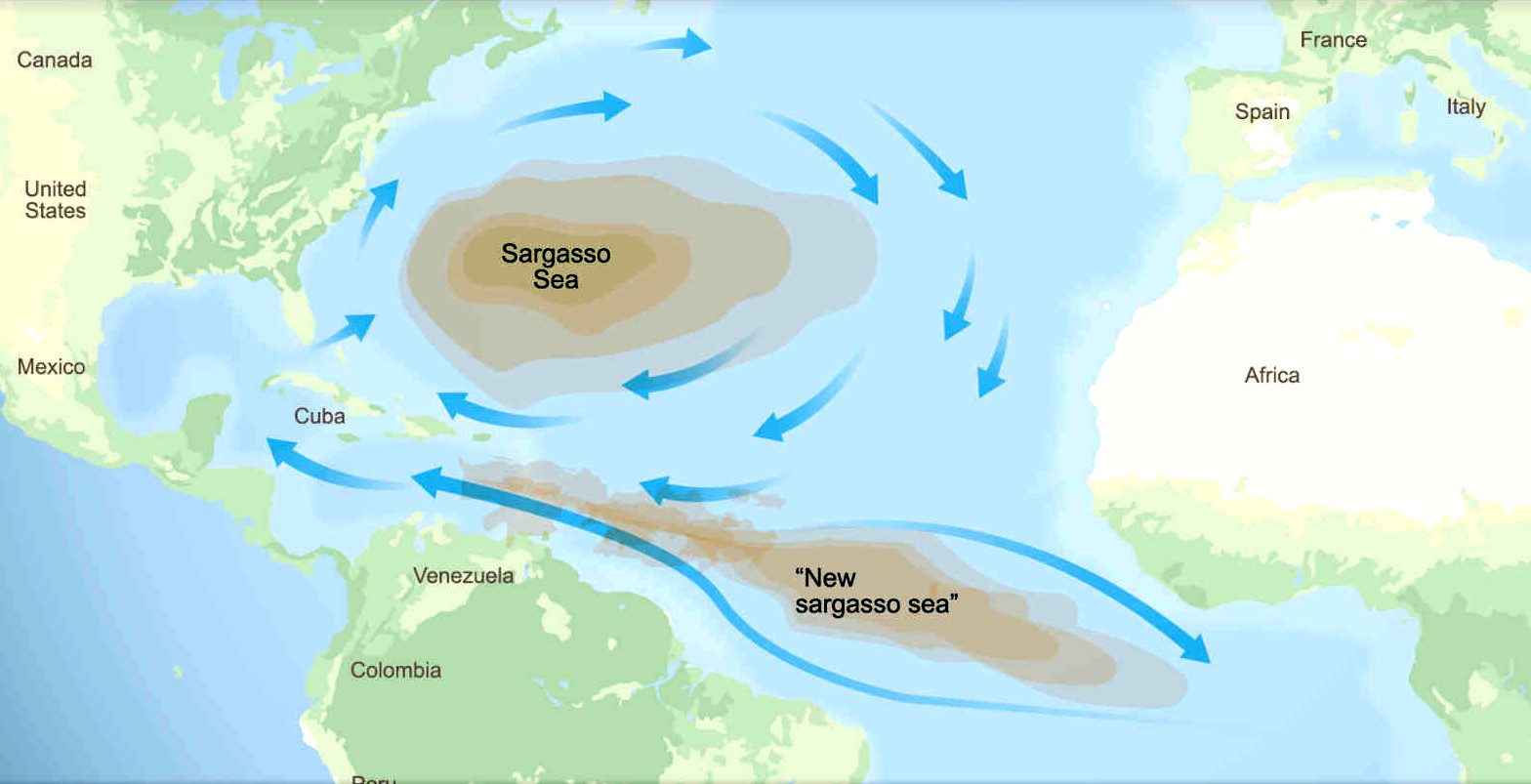
The Sargasso Sea was an artifact of nautical charts, featured in global maps that detailed ocean currents of the Atlantic for transit, the emergence of the Sargasso Sea–the “New Sargasso Sea” as it appears in news maps–demands to be seen as an artifact of economic processes of globalization, rooted in over-investment in fertilizer to provide food for growing populations, that result in increased sediment flow to the coastal and global ocean. Isn’t hot time to map it as such? Rather than a pool of water bound by the Gulf Stream and Equatorial Current, in this lovely nineteenth-century map, the once radiating Sargasso Sea nestled within ocean currents offshore has gained a new prominence as an invasive force, arriving at South and Central American beaches that seems to bridge our increasingly blurred continental divides.

As much as nestled within the open oceanic expanse, radiating peacefully in the open seas offshore, as it was in 1891, filling The Atlantic in rather dominating fearful ways, the sargassum is approaches our shores invasively, adopting the current metaphor for globalization, breaching the boundaries of familiarity of our comfort zone, no longer confined to the watery elements, washes up on our beaches, the arrival that seems nourished by river discharge from a far-off continent, in an age when nitrogen outflow has transformed the oceans from the innocent purity of a pale baby blue.

Atlantic Sargasso Sea, Peterman’s Geographie (Justus Perthes, 1891)
For the approach of this brown biomass that now bridges continents antiquates the idea of having one single, fixed perspective on the sea. We see the mass of seaweed as an invasion of territorial waters, a problem of coastal management, whose migration outside the ocean currents that bound the Sargasso Sea that spread across the South Atlantic, unlike the constant temperatures of the North Atlantic, the metaphors of migration in which this influx of macroaglal migration is drenched casts this Sargassum sea ass the detritus not only of ocean warming on a global stage–but as a natural event, removed from human agency and anthropogenic change created in large part by the remediation of soils of Western Africa and much of South America with nitrogen-rich fertilizer.
We are unsure of the relation to the growing brown-yellow biomass to our national waters, or the lines we draw around them, but are preoccupied that it is entering them. We might ask, however, why we are mapping the sargassum in remote sensing, we are projecting its origin beyond our own lands, and the scale at which we are depositing nitrogen-rich effluent into coastal waters at a terrifyingly high rate. The entry of plumes of nitrogen in the ocean is not defined by a fixed line. Indeed, the fixity of the ocean’s horizon might be a relic of the navigators of a more open ocean of the past. John Updike once parsed the maritime horizon that crisply divided the blue sky from the sea as a border between two worlds mirrored in elegant rhyming couplets–
That line is the horizon line,
The blue above it is divine.
The blue below it is marine,
Sometimes the blue below is green.
–whose elegant divide was fixed. Updike had attended as a graphic artist to blank blue skies, or snowy surfaces, or ocean surfaces, “tracing what I see with a mental finger or pen” while meditating on the limits of his field of vision. Crisp lines and fixed divisions are upset by the appearance of sargassum on the global stage, a blurred brown streak of a mobility that disrupts our categories of state lines and land-locked territoriality. But its appearance is also born of it. If Updike drew clear dividing lines of an almost early modern character in the romantic consciousness of a bored yachtsman off the New England coast, the drawing of crisp dividing lines in our ocean maps is disrupted by the exponential growth of a large biomass of sargasso about to make landfall along Central American shores. The increased coastal anxieties of the exponential growth in of macroalgae seems far away from the New England coast–however much algal blooms and sea-level rise, as well as erosion, threaten the Maine coast–but we might do well to start by mapping the sargassum of the South Atlantic from the perspective of the seaweed, as much a from the shores.
The rise of sargassum approaching the shores of the Caribbean may demand the reaction of national waters, but are in no small part the fruit of ocean pollutants and phosphorus effluents that are offering nutrients to the algae on unprecedented scale. Indeed the growing application of fertilizer to meet “local” demands of the production of food, from West Africa to the Amazon, suggest that the growth of this new abundant flotilla of Sargassum is a product of global trade–as much, perhaps, as the flow of migrants a respond to sharpening economic inequality, that demands to be mapped as such. If the hopes to harvest macroalgae on ocean waters encouraged oceanic clean-up operations as SeaVax to direct ambitions from industrial waste and oil spills to harvest the macro-algae by giant oceanic cleanup operation, in plans for the SeaVax-Sargasso™ or AmphiMax-Sargasso™ to meet the growing blooms of brown seaweed on the high seas from becoming a coastal threat, the aim to prevent the large brown seaweed from approaching national waters hints at how intertwined its biomass is with global economic exchange that this post tries to develop and expand upon.


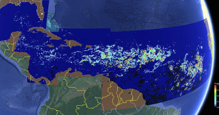
Atlantic Sargassum, 2023 and Exclusive Economic Zones in Caribbean Waters
As we map the flotilla Sargassum approaching Caribbean shores as a threat to “coastal waters” as it enters countries’ “Exclusive Economic Zone” and “national waters”, we remove the prolific seaweed’s unprecedented abundance from growing increased food from the lands by emending lands with fertilizer, rather than ocean warming. If entrepreneurial operations as SeaVax-Sargasso™ or AmphiMax-Sargasso™ oriented local businesses and governments to the surface of oceans, the global risks of nitrogen plumes in river run-off must be mapped far more deeply than the above satellite map of millions of metric tons of sargassum biomass, more often cast in terms of seasonal migration rather than the engineering of coastal waters.
The absence of clear lines in the Atlantic ocean, where the migration of macroalgae floats across high ocean waters, seems a canary in the coal mine of a warming world. One might see its sudden appearance as the result not of anthropogenic climate change, but an alien monster of global industry. Amidst 269,000 tons of plastic refuse floating on the undulating surface of global oceans, the thirteen tons of biomass floating in the mid-Atlantic may seem slight, but the astounding prolific growth of brown strings of algae in the Atlantic are an oceanic anomaly, moving shoreward, distant from the Sargasso Sea in Sargassum that long sequestered similar strands of seaweed in the mid-Atlantic amidst ocean currents.
Unlike the vitality long tied to the Sargasso Sea–first, a sea of monsters, but then a sea of untold fertility, a disproportionate producer of oxygen and carbon sink akin to a floating rainforest–the expansion of sargassum species has become a deep danger for our coasts and shores. It is as if spun off of the wild vitality of the Sargasso Sea, long an image of terror–the “Sea of Grassy Death,” for Mickey Spillane, littered with lost ships as a “living graveyard,” or “mystical ocean graveyard, hundreds of miles wide, hundreds of fathoms deep”–no longer constrained by ocean currents conjures cascading threats to coastal management in an age of climate change that knows no edges, not because of what lies hidden in its fearful deep–but as amorphous islands of expansive of algal monsters ominously approaching the pure white sands of beaches under seemingly bucolic skies.

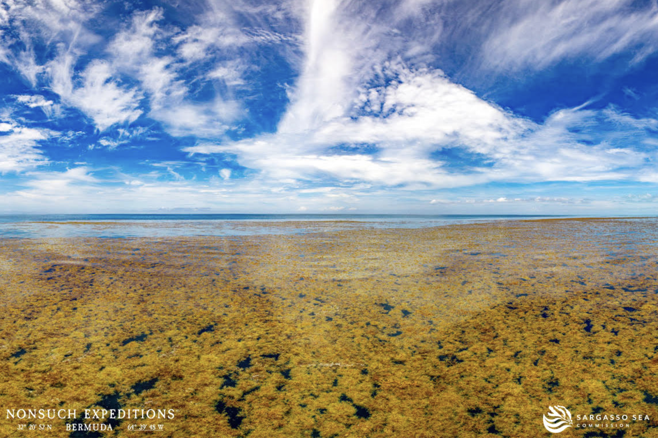
Sargassum courtesy Jean-Pierre Rouge
The strands of floating Sargassum were reinterpreted in the ecology movement, due to Rachel Carson’s classic work, as a site that nourished the abundant growth of microorganisms, a feeding grounds for fish and a floating rain forest of intense vitality: but the prolific floating Sargassum that now appears to extend across the Atlantic below the equatorial current is mapped as unwanted migrants, destined to foul the shores and coastal habitats across the Caribbean; the long strands of algal mats drifting on the ocean’s surface loom as the latest global casualty of climate change.
Charles Darwin, abord the HMS Beagle visiting ports on the Atlantic, took seaweed as a critical Rouregister of globalism. As he docked at ports in South America, Darwin gathered samples of algae that he collected samples, catalogued for his perusal what he perceived as a register of oceanic life and vitality, in ways that influence Ernst Haeckle and others: he sent weeds to correspondents from the Falklands and elsewhere as keys to the similar if unique habitats that evolved in benthic waters, impressed by the brown-green marcoralgae forests waving at him at the Galapagos, as if blossoming in the shallow, nutrient-rich waters of near coastal environments. The seaweeds were a basic register of biologic of global diversity studies on his travels, able to be sent on letters for future study–


–and of the primitive forms of life that evolved in the near shore rocks, evidence of the biodiversity of Atlantic waters and their vitality. But if Darwin collected Patagonian and other algae with care, the prolific biomass of floating kelp steaming toward Caribbean beaches out of control. Their extraordinary plenty in rafts of foot-long seaweeds are carried by currents destined as they wash ashore to kill coastal habitat and environments.
The abundance of the floating Sargassum, like a return of the repressed, removed from holists in coastal environments, again haunts the oceanic waters in an age of global warming in a monstrous manner, returning to prominence as an anomaly we are unable to catalogue or fit into our maps of ocean waters. Floating in international waters, the macroalgae appear removed from national jurisdiction, but is hardly “natural” in appearance. It has begun to mass over the Atlantic High Seas in recent decades, poised to redraw the margins of our coasts. The growth of inordinate algal biomass of algal strands are poised to swamp the divide between land and sea, as if a liberalization of the greenhouse effect, redrawing the margins of shores and land-sea divide. The growth of such an unprecedented mass of Sargassum, far from the confining currents that bound the Sargasso Sea, have been located across the high seas of the mid-Atlantic, but demand to be studied in relation to how nitrogen is entering our coastal oceans, shifting the ratio of phosphorous and nitrogen in the marine bath in which they float, as much as they deriving warming oceanic temperatures. The man-made nature of the anthropogenic changes in large coastal rivers–the Amazon or the Niger River basin, the Volta, and Mississippi–send greater blooms of nitrogen discharge in the Atlantic, shifting the chemical composition of coastal waters in unprecedented ways.
The blue marine is no longer only sometimes green, but often brown with algae. The blue marine is no longer only sometimes green. Covered with algal bloom, it is red, green, or often brown. As many coastal and lake waters gain industrial hues, unprecedentedly saturated with indelible hues of algal blooms, the rise of the Great Atlantic Sargassum Belt in recent years has become the latest evidence of the massive scale or cascading of climate change. We might imagine the bloom, given that it is viewable from space, as a surface mark akin to the storm of the Great Red Spot of Jupiter, but the abundant growth of seaweed, maps as a global disruption, evidence of how much “nature” no longer exists as a category. But if the Giant Red Spot is in fact a huge storm, a vortex swirling for centuries as a supersized cyclone–the largest storm in the solar system, enduring for centuries, far deeper than it appears from the gaseous surface–the undercurrents of the sargassum bloom are elided by remote sensing provides. Oceanographers distinguish ocean bathymetry as holding littoral, pelagic, and abyssal species, the shoreline clustering of seaweeds on rocky coasts are unlike the pelagic algae that seems a new seasonal visitor to our shores.

Coastal and Ocean Distribution of Brown Algae, 2020/published by Global Biodiversity Information Foundation
Anthropogenic influences on ocean waters demand unpacking the remove of an anthropocentric point of view Algal blooms–the massive efflorescence of Sargassum in the Caribbean, offering reminders (as if we needed them) of just how poorly adapted are mental constructs to understand the state of oceans. There may be some historical circularity in the fear with which the impending arrival of thirteen tons of Sargassum on the shores of the Americas and Caribbean islands is described: as the early modern sailors who were terrified of the Sargasso Sea as a point of disorientation, concealing monsters, we are terrified at the accumulation of brown coastal seaweed–macroalgae that floats in large masses, accumulating in the Gulf of Mexico and tropical Atlantic, in a dramatic deviation from the largely coastal settlement of seaweed across the globe. If the Sargasso Sea is as big as America, the belt of Sargassum spread across the Atlantic is as large or larger, if more dispersed.
Unlike the global distribution of brown seaweed on our coasts, the flotilla of brown sargasso whose density has caused such alarm is anything but natural in its copious abundance. The superbloom of brown macroaglal biomass that seems born by winds into the Caribbean is indeed a cause for alarm. The excessive abundance of this algae is a hyper-event, the latest evidence of the anthropogenic alteration of ocean waters, not directly driven by ocean warming, but the new nature of oceans. The increasing abundance of macroalgae were perhaps dislodged form the Sargasso Sea by the southern-shifted winds, where Sargassum were long confined by currents in the mid-Atlantic; the extravagant growth in global waters however, demands to be mapped. The feared arrival of the biomass that threatens to clot coastlines, basins, estuaries, and inlets this summer is the largest harmful algal bloom on earth. Yet our maps may not capture ho much it is the result of altered by human activity. We do not pause to analyze its appearance, or try to map it, as an anthropogenic effect, viewing the remotely sensed maps of its biomass floating toward our shores as if they migrated from afar, distancing the macroalgae on the high seas from any anthropogenic in origin.
The unprecedented offshore growth of a seaweed that offers precious habitat to life has accelerated in growth in recent years. The seasonal arrival of anthropogenically induced fertilizer has changed the relation of not only land to ocean, but ocean ecology, accelerated by increased rainstorms driving more plumes of nitrogen to ocean waters, including unknown amounts of deforestation-induced runoff excess sediment whose influence on coastal ecology demands to be better mapped.
")
The arrival of the thirteen tons of floating biomass into the coastal waters of the Americas is a cause for alarm–described as an “invasion” and “creeping threat.” Species of Sargassum have been arriving in Caribbean waters since 2015 in large quantities to pose a threat to coastal ecosystems as well as shoreline management. Large strings of algae of at least two species–and several varieties–have spread beyond the current-bound Sargasso Sea, floating on ocean currents across the Atlantic growing by vegetative growth, perhaps accelerated by warming waters, born by winds in ways that have echoed the cataclysmic metaphors we have been accustomed to describe migration. The appearance of what is cast as a problem of coastal management is newly prominent in global oceans as a problem of climate change: even if Sargassum are ecosystems with long historical roots, the exponential growth in floating seaweed has led to search for metaphors of a climate emergency and alarm bell of an anomalous growth of brown biomass, compromising the Caribbean beaches of countries where summer tourism is such a vital part of the economy.
Yet the exponential growth of Sargassum is perhaps better mapped as yet another fracture in the illusion of prosperity that drives globalization; evidence of the disturbances in the coastal biome of offshore life that has been triggered by the release of plumes of nitrogen from expanding application of fertilizer, from Mexico to Brazil to West Africa, whose discharge into the coastal ocean have set the stage for such a prolific algal super-bloom? We are overly comfortable, perhaps, mapping the “arrival” of the large biomass of kelp from remote satellite sensing, placing the bloom outside of our national waters, and the geographic space of a nation-state. We map the arrival of the astounding macroalgal mass that stretches across the Atlantic measured by remote sensing to grasp its density, by metaphors of migration of brown-skinned kelp as if they were “foreign” to our coastal ecosystem, possessed by economic fears, we adopt a perspective primarily from the coast, or an anthropocentric cartography, driven by feared economic vulnerability by which we map migration more generally, and in which migration often seems increasingly embedded. Perhaps it would be of help to map the arrival from a new sort of “story-map,” however, more tied to globalism and economic engines of globalization, from the perspective of the Sargassum itself.

Fearful of the anomalous expansion of macroalgal biomass that is floating across the Atlantic, heading toward our national waters, we map the arrival of the Great Atlantic Sargasso Belt by cartographic fictions of ‘Exclusive’ Economic Zones (EEZ’s), as if the ocean were a flat space, exploiting the fictional nature of maps to remain in our comfort zones. As much as the solace that was found in the sea, we are frustrated at the absent geometry to orient us to the seaweed floating in the Caribbean about to approach the web of islands at the edge of the open sea. The dark green surroundings of earlier eighteenth-century nautical routes magnified the equatorial islands of the Caribbean that were sources of economic wealth, as if seaweed clung to their coasts, before breaking off to join the dense fields of weeds that were estimated to b about 10 million tons by A. E. Parr to be circulating at the heart of the Atlantic, where Columbus first described seeing as dawn rose, on his first return from America, as being surrounded by “so much grass that it seemed to be the sea curdled with it, and it came from the West [en amaneciendo hallaron tanta yerba que parecía ser la mar cuajada de ella, y venía del Oeste” (Viernes 21 septiembre 1492)” on Friday, September 21, 1492.

If the “Relaciones y Cartas” that Columbus kept from his trip preserve a primal record of contact with the drifting, fragmenting, asexually reproducing, vital region of the Sargasso Sea, whose macro-alga only die if they are picked up by outward flowing currents from its permeable edges, the maps made for Columbus’ voyage were famously made to capture that the earth was not flat. And yet, we pretend the ocean is flat, and with clear edges, we fail to map the changed oceans in an era of climate change, whose cascading effects extend far beyond rising ocean temperatures. As much as it makes sense to see the seaweed blooms as result of rising temperatures, in an era of anthropogenic change. As coastal waters are increasingly defined by discharge of rivers of fertilizer feeding the Gulf of Mexico and the estuary of the Amazon, the river that feeds more freshwater to the ocean than any other, its sediment increasingly filled with phosphorous from its many sediment-laden tributaries, providing a nourishing bath for the Sargassum. The increased flux of phosphorus to the ocean has grown as Amazonia is clearcut, replaced by farmlands, and as increasing flooding from extreme weather, and cyclonic activity, washes organic matter to the ocean, to be released in its coastal ocean, that have long raised question of the phosphorous cycle.
The discharge of rivers that defined the Atlantic reveal the need for new tools of understanding the shift in phosphorus in the Atlantic in an age of globalization. The flux of phosphorous may help to track the explosive growth in the mid-Atlantic of sargassum, whose tangled strands have grown a hundred-fold since 2011, when they first appeared, to the south of the Sargasso Sea where it was long contained by equatorial currents. The irregular expanse of seaweed–thirteen tons of macroalgal biomass, we have no idea how to deposit or dispose, even in an era when Florida produced four times as much solid waste annually, and twenty times as much floating garbage lie in our oceans. In an era when plastic waste annually accumulates in ocean gyres, the stream of living seaweed has become, paradoxically, the latest cause for alarm, an unexpected anthropogenic substrate for bacteria, upsetting existing horizons for the gyres already accumulating in extensive pools of plastic waste across the North Atlantic, filling the seas with floating plastic debris, not to mention the microfibers that fill the deep sea–overlapping if not centered at the Sargasso Sea.


Can we better map the seasonal arrival of sargassum that is now again approaching our coasts in the midst of these changing seas? For those early modern Atlantic sailors, the region of the Sargasso Sea know no clear bounds–even as the early modern ties to South America were defined by creating clear meridians whose bearings were located in London, Paris, or, famously, the Cape Verde islands in the Treaty of Tordesillas. As the mass of tangled seaweed was feared to hide terrifying shoals and monsters, named after the Spanish word for kelp–sargazo–that swished again the prows of caravels, they realized this floating biomass was a new wilderness, sensing its brown-green surface concealed monsters or dangerous shoals against which they might be stranded, feared the Sargasso Sea as a foreign floating mass. The early mapping of the central role that such island would play in the sugar trade and slave trade was made quite prominent by Joannes de Last, head of the Dutch West Indies Company, whose volume on the Americas sought to make central their place for Europeans in their understandings of the new world, and new world trade, magnifying the seas of seaweed for public view circa 1620 off of the coast of Florida–her almost reduced to an appendage–in the image of the larger and smaller islands off of the Americas–

–the prime sites of interest for traders that he sought to put central importance upon for his readers. The shoals of seaweed that surrounded these islands, quite prophetically suggested the spatial centrality that they would gain within the expansion of Atlantic and global ocean trade. And the danger of these shoals, so prominent in mariners’ reports of their voyages, correspondingly occupied a central role in the immensely magnfied place of Cuba, suddenly as great as the island came to appear in American political debates of the Cold War, mapped in far greater detail than the loosely fragmented shores of a landfill-free Florida, a place that seems to register minimal interest.

Although the euphonious sound of this new marine oceanic body, later re-imagined a site of adventure or final frontier of wilderness by the early twentieth century–when many sailors continued to avoid the floating biomass–the arrival of the new variety of sargassum that is accumulating in long strands we are calling a Belt poses new fears for the modern nation-state since it appeared with surprising prominence in July, 2018–but has dramatically expanded by 2023. While we map the biomass from the perspective of shores, and from the fears it poses to coastal environments, the accumulation of seaweed seems closely tied to the displacement of phosphorous that heavy rainfall events increase by a factor of two- to four-fold. As anthropogenic inputs–and increased nitrogen fertilizer–stand to double phosphate flux to the coastal ocean, further accelerated by multipliers in an age of extreme weather, its entry acts as a biological pump, shifting the ambient waters for which it provides a nursery–
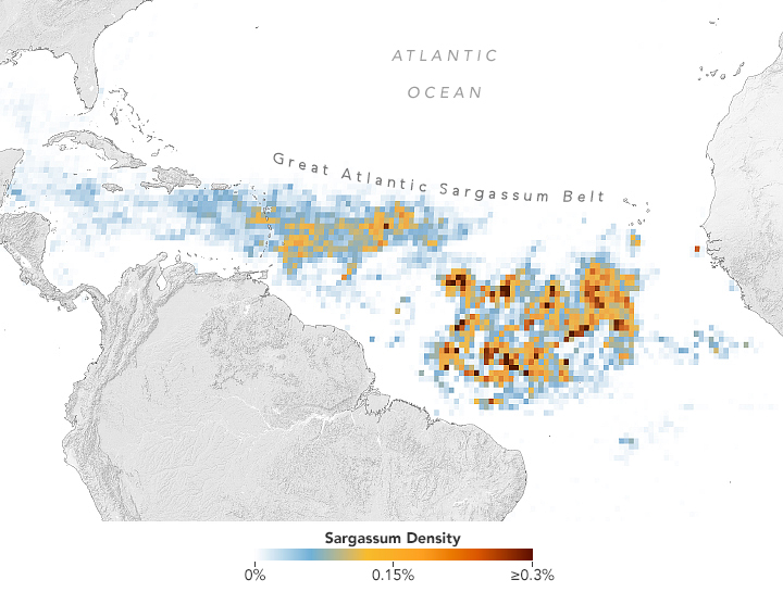
 on Terra and Aqua satellites to discover the Great Atlantic Sargassum Belt (GASB), which started in 2011. It has occurred every year since, except 2013, and often stretches from the west coast of Africa to the Gulf of Mexico. Credits: NASA/Earth Observatory. Data provided by Mengqiu Wang and Chuanmin Hu, USF College of Marine Science")
2015 Sargassum Density of Macroalage in GASB in Atlantic, Measured by Satellite Observation /NASA MODIS
–which a story or narrative of migration seems hardly able to capture. The complex problem of causation driven primarily by ocean circulation and rainfall threatens to remove the human agency at the origin of the massive macroalgal superbloom across the ocean, driven by a change in the ocean waters that the Sargassum species has long lived, but has become prolific across the Caribbean and Central Atlantic, rather than being confined within the rich habitat of the Sargassum Sea. If the delicate ecosystems that floating beds of Sargassum has created in the shoreless “Sargassum Sea” has been protected in international waters, and the contribution of the sea as a massive carbon sink in proportion to global oceans has led it to be called a “floating rainforest,” the robust growth of the pelagic algae demands increasing global attention–if its “migrations” are poorly understood only in reference to ocean shores. The astoundingly prolific volume of Central Atlantic Sargassum has boomed in a manner we cannot only understand by narratives of migration.

The clots of floating marine seaweed in the news–the Great Atlantic Sargassum Belt–is running across edges in troubling ways. The pelagic seaweed is suggestive of an upwelling of nutrients off West Africa, but seems arrival of blooms both off the coast of Africa and at the mouth of the Amazon suggest a new anomaly in the ocean, driven by the ocean circulation, unlike the binding of the Sargasso Sea by ocean currents. The GASB, stretching across the Atlantic from West Africa to the Gulf of Mexico, is an icon of globalism, one that demands mapping not only as an oceanic phenomenon, however, but a disturbance that seems deeply tied to the illusion of affluence that investment in fertilizer and the application of fertilizer to lands from Africa to South America, in an attempt to boost the agrarian self-sufficiency across the global South.
In contemplating the fixed line of the horizon, Updike, perhaps without ever intending, evokes the eschatology early modern transatlantic voyagers shared navigating high seas by dead reckoning and astrological bearings while they trusted to the divine. If early modern sailors were deeply disoriented by encountering the mid-Atlantic mass of swirling seaweed they knew as the Sargasso Sea–after the tawny tangles of floating kelp that swirl in its transparent waters, using the Spanish for ‘kelp’–saragazo–to describe the separate sea colored brown and gold, that was clearly a place apart, in Rachel Carson’s memorable phrase, “forgotten by the winds, deserted by the strong flow of waters that girdle it as with a river.. Trying to map the seaweed rainforest in their terms, long feared the dangers of hidden shoals or monsters, avoided by early sailors, and mariners through the nineteenth century, has long posed challenges because of its lack of edges. The half-rhymes of John Updike’s couplets of pentameter conceal a deep truth, but also also perpetuate a half-truth of marine edges, more than a deep truth of life at sea. If Carson believed that strands of seaweed were transported from the West Indies’ shores by hurricanes, carried up by the Gulf Stream, carrying marine creatures from coastal banks to the “new world” of the mid-Atlantic ocean, the size alone of the Great Atlantic Sargassum Belt–GASB–is a New World of unclear edges, registered by a dedicated Satellite-Based Sargassum Watch System that registered the wind-driven approach of floating Sargassum, whose greater density as they move westward qualify metaphors of migration.

The anomalous size of seaweed strands in the Sargassum Belt are not bound by any edges. Unlike Updike’s horizon, the floating fields of macroalgae brook little boredom in their undulating expanse. As it approaches our shores, nourished not by warming seas–as often imagined–it appears fed by weather of global warming have triggered discharge of more nitrogen in major rivers from Africa to South America, as flooding and torrential rains and extreme weather have channeled more nitrogen fertilizer than ever intended into the Atlantic waters. The anomalous size of seaweed distorts any clearly defined a line of sight. Indeed, if the ocean hardly prepared sailors for encountering the tawny tangles of kelp floating in transparent Caribbean waters in the Sargasso Sea, the surprise and astonishment of the appearance of sargassum that has grown is even greater. The extraordinary hundred-fold multiplication of sargassum that has since 2010 been clotting Caribbean coasts demands mapping not on two dimensions, as it is normally visualized, based on NASA’s satellite maps, but in the ocean’s changing character and indeed chemical composition, as floating and nurtured in an increasingly nitrogen-rich bath.
1. If the floating sargassum we track on the ocean surface does not seem a direct result of ocean warming, an anomaly of climate change, it is the fruit of extreme storms that have washed copious amounts of nitrogen-rich fertilizer that flows from our rivers, far from the agrarian soils they were intended to emend; we hardly track the entrance of nitrogen into the coastal waters of our oceans, beyond the continental shelf, but the new variety of sargassum clotting the coasts of Caribbean waters hold far greater nitrogen than the sargassum weeds floating to the north in the expanse of the Sargasso Sea, stretching from the Bahamas to the Canary Islands. If late nineteenth-century cartographers who perhaps mapped with greater surety than later generations fell back on nervously quivering lines to map, already realizing, it was indeed “a world apart” lying outside conventions of terrestrial or marine mapping.
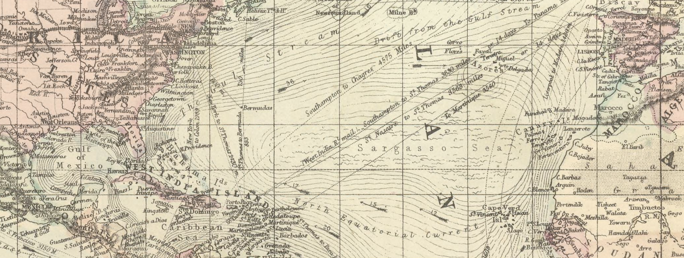
The tawny gold biomass swirling mid-ocean in the Sargasso Sea is not mapped by clear edges or blue edges: in 1875, cartographers rendered the long trails of sargassum seaweed that provide the Sea its euphonious name by quivering lines, between the North Equatorial Current and the Gulf Stream, two currents that set itself off apart from the mapped expanse as a region apart, perhaps suggesting the rich marine habitat it provided for fish, birds, and pacific pelagics, over a century before laws of ecological protections prevented marine trawling or harvesting of the sargassum in the region. Some of the plants circulating in the sea less defined by currents may have belonged to the gold-brown fields of sargassum that swished the prows of the caravels as Columbus returned to Spain, still circulating afloat in a region girdled by ocean currents–the prows of the boats broke flotillas of floating algae that “appeared suddenly floating a lot of herbs [Apareceiron parcels yerba mocha]” , Columbus wrote in a letter of 1493, far from the shores, soon described as its own sea. If the Sargassum Columbus encountered was feared, an d the fields of the Sargasso Sea avoided lest they entrap the sailing vessels or conceal monsters of a deep that may well have fed there, animated by the mirages of shipwrecked vessels condemned to rotate slowly in listless waters, as the ArcGIS story map “The Saga of Sargassum” suggests, after about 1500, we lack maps to chart the fear of Sargassum in an anthropgenic ocean pollution, we might start by better examining mapping the Sargassum we plot by remote sensing in relation engines of anthropogenic change–lest we allow the “layers” of ArcGIS to remap the ocean’s surface as if it were flat or had clear territorial edges.

Shifting Routes that Columbus Took in his Four Transatlantic Voyages in Relation to the Feared Sargsasso Sea
The mats of floating sargassum we map as arriving to our shores appears a different species than the sea, lying to its south, as a massive algal bloom. The Atlantic Sargassum Belt suggests its own parallel global reach. It colors the near offshore, without by fixed edges, but demands a new story map of sorts. In an age marked by anthropogenic change, our shores are blurred by red tides, blue-green macroalgae, and phosphorous-fed cyan-toxins that generated increased health advisories. As coastal waters across the United States are increasingly mapped by river-born fertilizer, we might well examine the appearance of an unprecedented on the open seas–over twenty million tons of floating sargassum, a blue-green algae, poised to clog shores and pose a real health risk, as fed and nourished by the increasing nitrogen concentrations in the largest rivers’ coastal plumes. To map the sargassum that has begun to fill the Caribbean since 2011, we would do well to explore narrative models beyond that of migration, all too often coded for immigration in national waters, charting the sudden appearance of the mass of macroalgae in the mid-Atlantic.
These are stories not only of living plants torn from their holdfasts in the coastal waters of the West Indies, ripped into the ocean by hurricanes to enter the northern border of the swirling Sargassso Sea, the metaphors of Rachel Carson, who so carefully oriented us to the ocean and the sea as an inadequately mapped area of vitality and life. If the power of her model of writing about the sea provided powerful precedent for how Jean Rhys finished later an alternative version of the literary classic Jane Eyre, of how Rochester’s first wife, Bertha, arrived in England, stripped of her West Indian name, Antoinette, after being torn from the island of Jamaica by Rochester, who took her properties and house as his possession, in a painful act of appropriation, and patriarchal authority, before he married Jane Eyre, embedded in a landscape of poqt-colonialization as much as the English manor. Rochester is described by Rhys as unable to orient himself to Antoinette’s land and life, disoriented and stunned before the blue-green sea of the island on which he never gained his sense of bearings–“‘Everything is too much. . . . Too much blue, too much purple, too much green.”
Rochester returned with his new wife to England from Jamaica mirroring the painful path of enslaved subjects in the transatlantic slave trade that formed Jamaican plantations, but also as a new model of extraction, and the extractive economies of the islands. For Rhys excavated the older transatlantic transit as a form of oceanic circulation; the backstory for the “madwoman in the attic”is revealed to readers as one of female subjectivity in the lens of colonization and expropriation, mapping offshore imbalances that may well have encouraged the recent sargassum superbloom. Antoinette half-conjured her ideas of her new home with Rochester as if from from a printed map– “England, rosy pink in the geography book map, but on the page opposite the words were closely crowded, heavy looking. Exports, coal, iron wool. Then Imports and Character of Inhabitants“–trying to grasp the global narrative of the extraction of sugar from plantations enriched men like Rochester to the islands, and its wealth. (She cannot imagines it as other than a place “filled with fields of corn like sugar-cane fields, but gold colour and not so tall,” trying to ken the global wheels of economy that lead Rochester; upon arriving in Rochester’s house, she fears she was in fact never brought to this place England, convinced “we lost our way to England” at sea, as we “changed course and lost our way to England, and that “this cardboard house where I walk at night is not England.”
The narrative of economic extraction of sugar cane and agrarian wealth that Rhys described in 1832, just after the alleged emancipation created a new class of indentured servitude in Jamaica, acknowledges the unequal history of extraction and economic over-production beneath a veneer of plenty that led to the far more recent over-enrichment of the very impoverished lands, emended with fertilizer, that have shifted the coastal waters in an era of extreme weather, flooding, and coastal hurricanes. The sudden appearance of sargassum on our radar occurred as the landings of seaweed into the western tropical Atlantic–the size of landings exploded on Caribbean beaches, tied to extreme climate events of 2009-10, seemingly shifting winds and currents outside the usual confines of sargassum’s range that had confined its growth offshore in the belts of ocean currents. We have come to map sargassum now by local “inundation risk” of landfall, an addition to our coastal ocean placing an increased percentage of shoreline at increased risk, mapping the “risks” of inundation faced by beaches increasingly central to the economy of islands and coastal states, as if it were just suddenly entering our national sphere of influence and economic impact.

We may be tragically purblind to the deeper changes far beneath the flat blue surface of the Atlantic, by which in real-time maps we charge its arrival against swirling arrows of winds and currents, lacking a truly volumetric qualitative map of waters that fostered its rapid growth. If we are alarmed by the arrival of the Atlantic Sargassum Belt that is a new creature of the oceans, something that never encountered in the mid-Atlantic but now prominent from space, might we better map not only a flat ocean surface, but a shifting configuration of land to sea?


CoastWatch, Sargassum Inundation Risk in Caribbean and Gulf of Mexico,Apr 25-May 1, 2023/NOAA
As our coastal waters are increasingly filled with accelerated algal growth, we have come to map shores and offshore waters as risk areas, neglecting how the growths are boosted by overabundant nutrients in river discharge from abundant use of industrial fertilizer, far outside the offshore waters to which the untold abundance of tawny sargassum was once primarily confined. As increasing nitrogen fills our coastal ocean, water acquires foreign hues of inkjet printers, as an overabundance of prolific algae clot coasts of the North Atlantic and are feared to wash across our shores. So, one fears, the arrival of the Great Atlantic Sargasum Belt.
The now-seasonal arrival of the macroalgae along Caribbean beaches, crowding out the stories white sands from the Bahamas to Mexico to Brazil, entangles shores, seas, and global ecosystems. If seaweed was an “inexhaustible wealth of wondrous forms” for Ernst Haeckle, whose hand-drawn images of radiolarians based on a thousand-fold magnification in microscopes provided grounds for the appreciation of natural forms–the abundance of seaweed is a problem show proportions we are not sure of how to observe, as it floats across the island, creating what once was seen–and is protected–as rich habitat for fishes, marine pelagics, birds, and microorganisms as yet the latest load of trash demanding disposal, leeching toxic sulfurs soon after it has washed ashore.
Coastal maps that foreground clear edges of shores fail to disentangle, or to blur, the way that the abundant generation of sargassum in our seas demands a new form of coastal mapping. In mapping their entry into national waters, we are often haunted by a metaphor of migration, fearing their impending landfall as a migration from abroad–across the ocean surface from Africa. But the long strands of sargassum that have flourished in our coasts was born in a bath of nutrients from rivers. The thirteen tons of free-floating macroalgae that favors temperate tropical oceans has gained new attention, enough to rouse the world from boredom at ocean swells. The fear of landfall grows as the sargassum bloom, now reproduced over a hundred-fold since appearing in 2011, is both fed by river discharge of the Congo and Amazon. While we map their seasonal arrival on the ocean horizon, as if it moves west to the south of the Sargasso Sea whose swirls are removed from shores, bound by ocean currents, the sargassum seems an invasive species we map as migrating. But in mapping the danger of the Atlantic Sargassum Belt by remote sensing, we are delinquent in failing to integrate its growing expanse to a global setting that has unintentionally saturated coastal oceans by anthropogenic nitrogen plumes, as extreme weather sends more and more manmade fertilizer in river discharge. Would a volumetric mapping help us to escape from the flat geographies by which we see the arrival of these floating mats as arriving on the sea from afar? It is all too easy to compartmentalize the “migration” of sargassum as a global artifact, destined once beached to release methane gases and hydrogen sulfide, a noxious smell toxic not only for respiratory health risks, but a unwanted potential public health risks for pregnant women.

Invasive Sargassum Belts Floating off Caribbean Island of St. Martin/Michel Vela (April 2018)
The half-rhyming couplets of Updike’s pentameter evoked perspective of a yachtsman more accustomed to hugging the shore than to high seas, and the lack of clear edges in the densely populated Sargasso Sea suggests a pool of algae without clear edges, bordered by islands from the Azores and Cape Verde in the east and surrounding Bermuda and the West Indies to the east, in a floating expanse that is hardly blue, even in Caribbean waters: we imagine the floating surface of sargassum, akin to Updike’s yacht, moves on the surface of the ocean, and map a two-dimensional image of it as advancing across the Atlantic Ocean below the equatorial current, but would do well to consider how a volumetric map of the seas might far better describe the huge macroalgal bloom.
Seaweed, Rachel Carson emphasized, inhabit an inter-tidal zone, if their “dark, mysterious forests” often “go down into deep water,” as evident in the giant key that are often cast ashore, if most kelp’s holdfasts are rooted to a rocky shore, and other inhabit the deep waters or polar sea. She believed that the sargassum of the central oceanic regions had entered the area bound by the strong flows of the Gulf Stream and North Atlantic Current from the coasts she loved, imagining that the “brown alga that lives attached to the rocks along the coasts of the West Indies and Floridas” were “torn away by storms, especially during the hurricane season,” to be picked up by the Gulf Stream and head north, bearing “as involuntary passengers . . . innumerable larvae of assorted species of marine creatures.” Although the Sargasso Sea becomes a destination itself of many pacific pelagics and fish, the prime role that she gives to the hurricanes in shaping the sea reveals a keen sense of the impacts of oceanic movement.
If the sargassum that was so feared by sailors in the Sea nurtures creatures attached to the “weedy jungle” to which they cling as a life raft, the lives of the sargassum by which the vast sea is defined as a land apart, inhabited by millions of tons of sargassum, seems a place where they may drift “endlessly, growing, reproducing vegetatively by a process of fragmentation,” outside time, perhaps including the very same weeds once passed by Columbus with fear. We are more reasonably afraid of the sargassum that has multiplied open the open ocean, to the south of the sea and the Great Atlantic Current, the 13.5 million metric tons of sargassum are poised to arrive at are coasts in far more time-sensitive ways. For as the sticky mats of meter-long strands of sargassum leave international waters, the very weeds that were the necessary habitat and spawning grounds for pelagic eels, sea turtle, fish and marine mammals, rather than offer “cover” as a floating island, is a threat to coastal habitat–and to the beaches of the shores where they are destined to make landfall. While we view our Florida beaches as sites for summer vacation, the arrival of seaweed is not only a nuisance, but the scale of the golden brown biomass offshore is a cause for global alarm.

“Seaweed Blobs Headed for Florida”/New York Times (Apri 19, 2023)
The appearance south of the Sargasso Sea of a flotilla of sargassum of unprecedented biomass may seem a new continent in the ocean, without clear bounds but of global significance worthy of preoccupation. Rather than bearing the creatures and microorganisms they host as distributed over ocean waters, invasive sargassum stands to threaten the reefs as they obscure transparent Caribbean waters as a layer of opacity, clogging the benthic habitat and, as they beach, releasing toxic vapors after two days. The amalgam of macroalgal kelp floats on the ocean’s surface, no longer bounded by currents’ flows, as the Sargasso Sea, but decaying soon after making landfall as it beaches ashore to pose problems of disposal we have no clear answer. Even south of the rich Amazon Reef System, the vital clustering of areas of rich species richness along South American shores that lie just within the continental shelf slope threaten to be covered and clotted by long weeds of sargassum that prevent sunlight from entering the blue caribbean waters of the Atlantic.
The flotilla of over thirteen and a half million tons of seaweed mapped by remote sensing have been cause for global alarm and anxiety as they seem to be entering our national waters in mid-March. The arrival of a long belt of sargassum seaweed, far below the channels that bound the swirling calm of that massive tide pool, demand a deep plumbing of its origins, as hidden as the deep sea that roils beneath the deceptive calm of the marine surface of the Sargasso Sea, with global ties as deep led Jamaican-born Jean Rhys to adopt the poetic figure of seaweed weaving a hidden tapestry across the Atlantic’s surface to span a global narrative from an English novel. Rhys, whose mother was Creole, reacted viscerally to Charlotte Bronte’s characterization of the madness of a creole first wife of her heroine, offering a backstory of the madness that led her to be confined that took its bearings form the plantations we do not see in Jane Eyre, but become a psychological backstory in what might be an early example of Atlantic history. Her title adapted the swirling Sargasso Sea that surrounds Jamaica, that Carson had characterized as spanning the ocean in a world apart, to ready readers for an interior geography that reveals the global reach of the cruelty of enslavement in the Caribbean plantation slavery in a postcolonial world, whose reach after, long emancipation, spans the worlds of Jamaica and the England: Wide Sargasso Sea orients readers to an encompassing toxic masculinity based on poisoned race-relations and intermarriage, almost titled The Creole, spools its story of an unruly web sprun from one side of the Atlantic to the other–from Jamaica and the island plantations–the trans-Atlantic slave trade mirrored in the first marriage of Rochester as a tragic prefiguration for the destiny of Jane Eyre, rather than confining Bertha to the attic as a madwoman who remains unknown but as Rochester’s first wild, creole wife.
The destiny of the first wife who Rhys felt a haunting absence in Jane Eyre stands at the center of the racial tensions the island of Jamaica was infected–moving from the tensions in speech and actions of maroons who had escaped slavery; blacks; mixed race and English. Her own perspective led Rhys to root a global drama of tortured patriarchal relations in plantation life, that circulated transatlantically to England, mimicking the currents of the actual Sargasso Sea. If Bermuda, in the Sargasso Sea, was believed by early moderns as “the Devils’ Island,” inhabited by devils and “feared and avoided by all sea travelers, above any place in the world,” per William Strachey, secretary-elect of Virginia, in the early seventeenth century, Rhys argues the fearsome nature of slavery itself in an Atlantic narrative too often elided by European novels, with origins in transatlantic trade, and the absent British landlords. Reading Rhys as an early critic of colonial globalism, one might find cues to read the biomass, not only against global warming and increasingly violent summer storms that flood regions recently converted to agrarian ends, a complex web that leads annual flooding to stream nitrogen fertilizer in plumes far beyond national waters or exclusive economic zones.

Nitrogen Plumes Released to North Brazil Current (NBC), Guyana Current (GC), and Equatorial Currents, May-June, 2010
Even mores for the flotilla of sargassum mats mapped across the Atlantic. To map the biomass of the Sargassum Belt, we would do well to leave a two-dimensional mapping, and examine the interaction of this new species of floating sargassum that is arriving south and easterly of the swirling Sargasso Sea, but churning in the ambient waters of increased phosphorous as it approaches the America, that expand its reproduction. If the life cycle of the sargassum ends quite quickly when it comes ashore, exiting the nourishing oceanic habitat that led it to flourish, as it is beached ashore, as the tangled agal mass decomposes rapidly after landfall, its sulfur emissions are of a toxicity that cause acute respiratory problems, multiple side effects, especially for pregnant women; it will also, without being sunk, releases methane, a greenhouse gas that we are attempting to reduce–the biomass of over eleven million tons we are warned “is coming to shore” in coming months, as a 5,000 mile long train of macroalgae enters our national waters, stands to clog benthic habitats and coral reefs, and give of an obscuring stench as it fills the white sands of Caribbean beaches, although the economic impact on tourism is perhaps as two-dimensional way of mapping its arrival as seeing the massive belt as floating on the ocean’s surface, as Updike’s yacht.
The arrival of massive rafts of this deep green brown invader of clear waters is not only an opaque layer of seaweed belt, a displaced denizen of the High Seas, floating outside a region where its tangles are habitat and shelter to marine pelagics, from birds to fishes to sea-turtles to snakes to whales. The impending arrival the floating mass of the sargassum belt was mapped by NASA Earth Observer’s remote sensing has caused alarm, but the news growing mass this Spring has seemed to reach American news cycle several years late. While its notable growth was measured already ten years back, the two-dimensional mapping of the seaweed as a brown mass, visible from outer space, has become incorrectly seen by metaphorically cast in terms of migration. To be sure, the arrival of the toxic clotted algae raises questions of the inadequacy of such constructs as territoriality, sovereignty to manage the arrival of the abundant algal bloom washing ashore from international waters. But the multiple dimensions of a map of tis increased reproduction must begin from the anthropogenic waters it is encourages its massive growth, akin to steroids, as extreme storms are pushing more and more fertilizer from topsoil across the Amazon and Central America, creating a bath for its reproductive growth.
Unlike the mats of seaweed in tidal pools, rooted to hard surfaces by holdfasts, that Carson studied, these mats of macroalgae may seem to migrate seasonally to our shores. The news cycle depends on metaphors of migration, driven westward by ocean currents, “heading westward” that anticipate the dangers of its landfall as the rafts of kelp enter our coastal waters, far south of sargassum’s normal range. But the seasonality of their arrival, rather than being driven only by warming waters, or the best known “agent” of climate change, are keyed to river discharge that has fed sargassum both in the Atlantic much of the Atlantic ocean currents.

Sargassum Makes Landfall at Playa del Carmen (July 4, 2021)/Eyepix/Nurphoto/AP
For the Caribbean islands stand again at the center of an entangled web of enriching soils to ease economic imbalances, this post suggests, as plumes of synthetic fertilizers enter the western North Atlantic, sending out nitrogen plumes to the Great Atlantic Current, rather than sargassum whipped by hurricanes from the island shores and coast of Florida to enter the Gulf Stream, as Carson believed, beyond national waters. The origins of Atlantic Sargassum Belt mirrors the new proximity that global warming has brought the seas around to over-fertilized agrarian lands, as tropical cyclones of increasing intensity drive river discharge rich with nitrogen out to sea to promote algal growth.
If the form of seaweed was long known to biologists, and even extolled as a rich offshore habitat, in the past ten to twenty years, the appearance of an entire new population living near the equator is preoccupying many, as a new continent-sized mass stretching from the coast of western Africa’s coast to the Mexican coast to the Caribbean. It threatens to cover the shores of Caribbean islands, if it is not netted offshore. NASA’s Earth Observatory registered a “massive seaweed bloom in the Atlantic” approaching our shores, its biomass dissolved as pixels, poised to enter the American hemisphere and United States’ sphere of influence, America is late in noticing the biomass that has set new records for its seasonal appearance. But the a belt of rapidly reproducing macroalgae has hit the news cycle in anticipation of its landfall on American beaches.


NASA Earth Observatory/April 8, 2023
Mapped from the Canaries to the West Indies, against a blank background, we remove the anomaly of its presence from the rich sediment of the coastal ocean that nourishes the Sargasso Sea, or the phosphorous that now feeds the coastal ocean. If the disturbingly high density of its presence–already thirteen million tons in mid-March–is isolated as the latest whacky disturbance of the Anthropocene, of unprecedented density, just below the currents that bound the Sargasso Sea, this new species of sargassum that seems to have sprung from the deep is fed by the boosted nutrients coursing in coastal oceans, and taken up by Equatorial currents, of nitrogen fertilizers that have altered the ocean waters.
If we map the sudden recent density of the new species of sargassum floating across the central Atlantic into the Gulf of Mexico as a disturbing violation of ocean boundaries that raises questions of the law of seas, its mass suggests a global presence we have trouble to process. If the Sargasso Sea was long cast as a site of mystery, by mariners who feared becoming prisoners of its swirling algae, unable to orient or right their course and becoming removed from solid ground, this blog post invites us to consider how land and sea are bridged not only in the Sargasso Sea itself, but the emergence of the Belt, and how much maps have served us well to comprehend its growth.
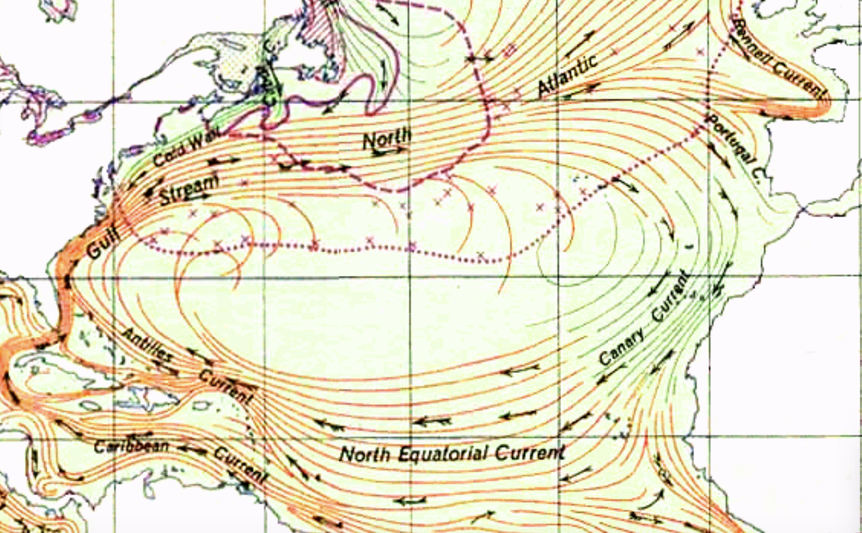
Ocean Currents and Sea Ice, US Army (1943), detail
1. Rachel Carson, who has helped orient ourself to the life-filled edges of oceans, found the “Sea” helps us think differently about edges, if not oceanic expanse: the world that it presents is an assemblage, floating in blue transparent waters of the mid-Atlantic. The swirling sea blurs our sense of edges, and extends to the deep sea in a rich ecosystem, asking us to shift attention from edges, to call attention to the curious dynamics of the space. In 1870, a generation after Maury’s map, it was defined by quivering lines, akin to a protoplasm, in an age of increased cartographic objectivity– nervously drawn squiggles in the Atlantic, in the Mercator projection, bounded by the Gulf Stream and North Equatorial Currents, not clear lines. A site of fascination, its place name a different font from any other site, the quivering Sargasso Sea appears a region that shipping routes largely tend to avoid–the active energy of the region seems to be set against a divided globe.
World on Mercator’s Projection, 1879 (detail of Sargasso Sea, magnified below)

Courtesy David Rumsey Library, Stanford University
Tons of sargassum–now some ten to twenty million tons of algal weed–floating outside the famous Sea have been likened to a floating continent in the mid-Atlantic, not swirling in the Atlantic around the outer islands of the Caribbean, but stretching from African coast.
The floating belt of sargassum algae now floating westward across the Atlantic is distinct from the Sea. If the Sargasso Sea was a site of nourishment and habitat, the weeds have merited attention of the news not only as a poor omen for summer beaches, but as an ocean we no longer know how to manage, and indeed a biome we are managing in increasingly poor ways. We map the floating algae as the latest unwanted assemblage born of climate change even though the seaweed’s growth would be curtailed by warming ocean water. But as ever increasing storms produce greater runoff fed the ocean with a bath of nitrogen-rich agrarian runoff, the increasing seasonal expansions of the belt below the Gulf Stream suggests a mystery of the Anthropocene.
Fears arrival of a mass of seaweed–visible from space, and mapped by remote sensing in all its biomorphic bulk of a boom of over twenty million tons–by some estimated to be above twenty-four million tons–seems less a bonanza than a symptom of the oceans’ poor health, and the latest source of anxiety. The roiling weeds seem a floating continent that is about to make landfall in America, a waiting time bomb for the release of all that seaweed’s waste and methane gas after it arrives on American shores. Mexican marines had removed some of the twenty million tons of brown sargassum since 2018, as its rapidly increasing biomass was linked to the growth of riverborn nitrogen both from fertilizer and carbon emissions in the coastal oceans linked by the mid-Atlantic Sargassum Belt, seaweed that emits a toxic sulfates soon after it is beached. The massive seasonal growth each spring and summer poses problems of the emission of smelly, toxic gasses, irritating the respiratory system and the eyes–evident in satellite imagery as the largest harmful algal bloom on the planet–that will live long in the ocean, but dies after two days on land, releasing toxic gas. Its increasing global presence is yet another nightmare of the Anthropocene.
–that will decline only in the fall and winter months, when less sunlight arrives to encourage its marine growth.
In sharp contrast, Carson followed Thoreau in searching for the “tonic of wilderness” in the Sargasso Sea–as Thoreau found an antidote of sorts for civilization in the wild just outside of Concord, on the shores of Walden Pond, Carson meditated on the shoreless sea as a site of organic vitality, shifting American readers’ eyes from cities in ways that challenges us to move beyond a anthropocentric perspective or line of sight. It was hard to imagine how the curious Sargasso saw itself, or would position itself, seemingly diffused across space, as much as a bounded region, isolated apart from the syntax of maps of nation-states. In Matthew Fontaine Maury’s 1855 Physical Geography of the Sea, it is a grassy patch of seaweed, between the Canary Islands and Bermuda, in a gyre; in later ocean atlases it was a curious patch of green dots.

Matthew Fontaine Maury 1855), detail of “Gulf Stream and Drifts”

Sargasso Sea (1873, rep 1886)
Long seen as treacherous to sailors, the Sargasso Sea was long difficult to map because it was outside of our fundamental mapped categories of land masses, a floating surface. Perhaps because of its intriguing algal network without any clear bounds of land, the sea attracted the attention of Rachel Carson, who taught us much about the permeable edges of marine life, as “different from any other place on earth,” a place apart on the high seas, a sea with no shore. How did all these weeds arise in the mid-Atlantic? Were they born by winds that tore them from the shore?
The rich floating habitation marks a new space in the open ocean, its surface covered by ten million tones of tan sargassum as far as the eye can see. Carson called attention to the immense habitat of its large biomass–imagining a compounding of seaweed torn from the nearby shores, swirling within the protective bounds of ocean currents that nestled its flow. If seaweed is currently being re-conceived as a potential carbon sink, able to suck a disproportionate share of carbon from the rest of the ocean, the mats of seaweed and macro-algae that make up the Sargassum Belt may have been stimulated by the latest entry of -the seaweed that grew in the ocean was encouraged by the rich river sediment from the Amazon and other shores, sucked up into its gyre, as much as seaweed torn from its shores, that has allowed the protected algal mass to thrive. Shown by quivering lines in an age of increased cartographic objectivity, as a vital site, a place that was not only “apart” but preserved a wild that stood in contradistinction to the “depressing record of destruction” man has waged “against the earth he inhabits” that, she feared, diminished us all as humans. The relatively recent expansion of the GASB, however, seems an addition to that record–no longer sequestered in the ocean currents, but stranding on shores from the Caribbean to West Africa, where they threaten coastal ecosystems and biodiversity.

The whirling tawny golden of kelp that grew across the sea is truly a marvel and a place apart. The Sargasso Sea offered the illusion to sailors of a dangerous trap to Columbus, and many sailors mistakenly took its size as a pernicious danger for ships navigating the high seas–believing the fields of swirling algal fields were indications of reefs below on which their ships would risk running ashoal before their arrival at their destination, or were indeed just good omens land was nearby. The tawny mass is neither blue or blue-green, nor anything in between. The Sea was a marine wilderness that is largely unknown: Carson fancied that visitors to the Sea might see the same sea-plants that were seen by Columbus and his crew, as if the weeds were a surviving state of nature in the offshore. (Fifty years before she wrote, the Sea was a site of romance for adventure stories of the open ocean as an unknown edge of the earth.) Of a size that was indeed about as big as America itself, and vitality that demanded to be known, akin to an unknown floating continent. For the biodiversity that differs from any other ecological niche as grounds for spawning and foraging, a habitat that is also a destination for endangered pelagics.

Distinct from most mapped regions for lacking any boundary or shoreline, it is not defined by blue edges, by bound by oceanic gyres not able to be seen from sea. Outside the any government body, or Exclusive Economic Zone, it has limited legal protections. If the Sargasso Sea eludes national bias of mapping, outside international bounds, its fragile overlapping floating ecosystems were only recently protected due to a joint governmental accord–a conveyance that might be called the fruit of globalization–between the Bahamas, Bermuda, Dominican Republic, the Azores, British Virgin Islands, Principality of Monaco, United States, and United Kingdom, protecting the High Seas span across two million sq nautical miles recognized as complex locus of oceanographic migration. Often compared to a “golden rainforest,” in ways the mirror of the rainforest of Amazonia, its canopy stretches across the high seas, and extends deep into marine depths below 4500 meters, as challenging to map as it is to models of management for marine sanctuaries.
Perhaps because she was impressed by the poetic powers of Carson’s 1950 disentangling of the copious ecosystem of the Sargasso Sea, novelist Jean Rhys retitled the novel she was working set in the Caribbean that describes the first Mrs. Rochester, a revision of Jane Eyre, in a post-colonial optic, set just after the abolition of slavery in the sugar plantations of the English Empire. While the title replaced the more racially explicit The Creole, or, after a Caribbean spiritual, Gold Sargasso Sea–a plantation song–Wide Sargasso Sea captured a broad encompass of a tangled lineage, after the tangled seaweed, in the modernist masterpiece that expanded race, Caribbean history, and forced social marriages echoing the tangled violence sugar plantation, Coulibiri, across the Atlantic world. The Wide Sargasso Sea is a truly wild sea, marked by upwellings of rich minerals and churning up of long suppressed genealogies of the Atlantic slave trade, absent from Charlotte Brönte’s 1847 novel, Jane Eyre, set just after the Slavery Abolition Act of 1834 nominally liberated enslaved at plantations as Jamaica,–“No more slavery! She had to laugh.”–that is told in the optic of patriarchal domination. The “dark space” of the plantation and its un-English environment maps a backstory of the “Madwoman in the Attic” as a tortured space of female subjectivity spooling forth from a place where “Desire, Hatred, Life, Death came very close in the darkness. Better not know how close.”
The plantation life of removed landlords in the West Indies islands form the previously unwritten background of the first Mrs. Rochester. And from the moment she overhears estate workers wonder at the impending plans of her stepfather–“‘a wealthy man who could take his pick of all the girls in the West Indies, and many in England too‘”–to remarry her mother, and gain wealth and an island estate in the Bahamas, the transaction of a removed landlord echoes a plantation economy built on the slave trade. The voiced fears about the marriage are a premonition of her abusive marriage to Rochester and indeed that of Jane Eyre–if Jane Eyre and Antoinette, the future Bertha Rochester, never meet in the world of the novel, the parallels in their lives take their spins form the global diaspora in which Rhys placed the novel’s layered dramatic tension. After nominal emancipation, the West Indies plantation remained a nexus of the sugar trade that defined wealth in the British Empire–as they did earlier of France–and were measured as lands of enrichment distant from the Paris or Greenwich meridians, diasporic settings of extraction on the edges of empire. If slavery had been abolished just before Rhys set her interior work, the absence of a clear land reform or legal structure not only left calypso a compelling form of social resistance and redress, in popular song and performance, as a running social commentary on the backstory of Jane Eyre, rooted in a quite often subversive Afrocentric orality, that offers a moral center to the tragic prehistory, akin to how an Afrocentric spirituality argued to offer Rhys’ heroines an “alternative epistemology”–if not an alternative spatiality to plot the colonial relations to the islands of the West Indies, viewed not only as a site to generate domestic wealth–as in Jane Austen’s 1812 Mansfield Park, but a sense of agency and moral redress against a stifling patriarchal silencing, echoing the derision of English institutions vocalized in transgressive song. Is it a surprise that the title took the name of a calypso that Rhys had penned herself with her cousin, in the French patois of the working class, also known to many of the colored mulatto élite? The revolt of slaves in the area of Suriname and Guyana had been romanticized as a trade in women by William Blake who illustrated the early printed history of John Gabriel Steadman–Narrative of the Five Years’ Expedition against the Revolt of Negroes of Suriname, in Guiana,

–setting the cruelty of enslavement against an exotic landscape was a stock trope.
The drive for extraction wealth from West Indies plantation demanded reorientation, and reorientation to the generation of imperial wealth in Jane Eyre, which silences Rochester’s first wife, Bertha, or Mansfield Park (1812), itself haunted by revolutions on overseas plantations, vaguely described “concerns of West Indian property” without faces. Rhys illuminated a critical backstory of domestic patriarchy, and logic of extraction that echoed in current attempts to resolve problems of dire poverty and promote an image or veneer of prosperity, in this case by the quick fix of emending new farmland by fertilizer to engineer agrarian self-sufficiency and a veneer of economic prosperity to the southern hemisphere. The arrival of fertilizer in West Africa, the clearcut lands of the Amazonia, and Mexico proceeded in the past decades under to offer food security to growing populations. As if to echo howJamaica, Antigua, and Barbados enriched European Atlantic empires, by extraction, investment in agribusiness that has transformed rainforest to fertilized plains has provided less of the positive effects it promised with increased amounts of nitrogen-rich fertilizer flushed in plumes out to sea, returning in a bounty of stranded Sargassum onto the shores that are providing the prime basis for economic security to many of the islands sugarcane was farmed.

J. Bellin, Petit Atlas Maritime (1764)
In our own maps of the arrival of sargassum belt, we must separate ourself from the perspective of removed landlords, reentering the Sargasso Belt seen as arriving from international waters, but examining it as a tortured product of over-fertilized land. Rhys revealed a rich patios the novel often neglected, in the English novel, mapping the exchange of brides as a wide sea of tangled webs across the Atlantic, familial and imperial, in a emotionally quite tangled racial origins of a heroine and English wealth from plantations that, as a gyre, spread its global web across the Atlantic, in ways that may have been informed by Rachel Carson’s earlier work on the Sargasso Sea as a hidden habitat situated between two continents, the exuberant growth of seaweed belts in recent years demand better mapping. The Sargasso Sea offered little or no safety form some swimmers off Jamaica, where sargassum makes its waters dangerous to many, and the arrival of sargassum in the mid-Atlantic is indeed a serious public health threat. If Rhys played with numbers of titles to capture the geography of the plantation and its extraction of wealth, including both That Wild Sea of Weeds where I was Wrecked (the voice of Antoinette, perhaps, or Rochester himself, whose voice is also in the novel) and That Wild Sea of Weeds where They Were Wrecked–gesturing to the geographic centrality of the Sargassum Sea that was imagined as a derelict space of swirling seaweed and ruins of old ships; the lonely plantation song that Rhys’ cousin from Dominica called a “Creole Song,” “Across the Gold Sargasso Sea, I watch my heart come back to me,” led her to consider Gold Sargasso Sea as a title, but the region where the trade winds grew and the cruel transatlantic slave trade spun out came to embody the social network her novel came to describe. Can we map the economic inequities that have, as much as the storms of global warming, created the latest marine anomaly?
It is as if the expansive proliferation of floating seaweed may be the unintended consequence of expanding investment in fertilized Caribbean soils, under the mantra of self-sufficient agriculture. While advanced by the World Bank as a quick fix for agricultural expansion, the global oceans are bearing the brunt of the region are investment of nitrogen excess in an era of severe weather, as the very same islands stand to bear the unintended brunt of a destabilized coastal ocean. If the world of global fertilizer has boosted crop production, the increased availability of nitrogen across the Atlantic basin has spread to the High Seas on both sides of the Sargasso Sea–increasingly under attack not only from plastics and ships that trawl for fish or cut across its kelp mats. Invertebrates, ocean upwelling, and transforming a “nursery habitat” for fishes into a site for massive harmful algal blooms. The abundant foliage of plants Charles Darwin had studied intensively by the samples he had captures in his 1835 voyages to Caribbean ports, the chain of life that he sought to decipher from the weeds suggested a stable balance of life that the abundance of Sargassum seemed to reveal to be radically and profoundly upset, if not destabilized and out of the possibility of management. If the new taxa of tropical plants held a stable place in Darwin’s herbarium, the placement of Sargassum seemed a disturbing displacement of the high seas to Caribbean waters.
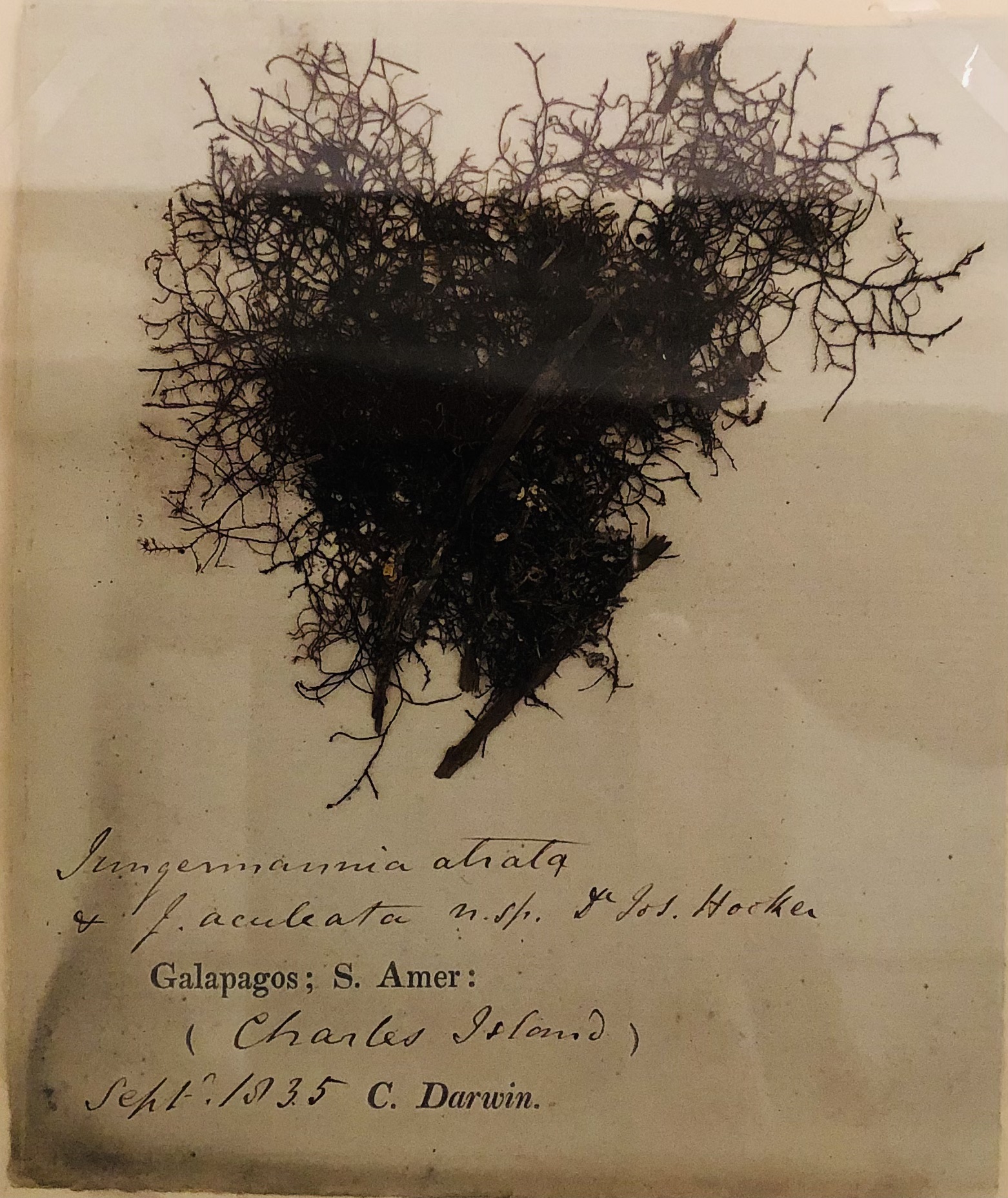
Darwin’s Sample of Seaweed Taken from Charles Island, Galapagos, South America
Yet the scope of the global problem of abundant seaweed moving , if tied to World Bank subsidies for farming, suggests that since 2010, the availability of new nitrogen-rich nutrient sources provided a fertile bath for brown macroalgae across the Atlantic due to Spring river discharge with increasing quantities of nitrogen from agrarian runoff, unlike the historic upwelling of ocean floor sediment–evident, per LaPointe et al., in the presence of nitrogen after 2010 in new clustering of rafts of sargassum in the Gulf of Mexico or off Florida, unlike the sargassum in the Sargasso Sea.

Sargassum Reflecting Nitrogen Availability in Atlantic Basin, LaPointe, Bretton, Herring et al. 2021
The flotilla of sargassum mats are a substrate of a global economic inequalities, as much as climate change. It is a reflection of subsidized investment in agriculture that in recent storms brought increased runoff in the coastal oceans from increased fertilization with nitrogen, in an attempt to emend soil nutrients for food production–an over investment designed to foster to end economic inequality in the southern hemisphere, from West Africa to South America, begun in the development projects from the 1990s, before unforeseen extreme weather of downpours and hurricanes spilled the nitrogen into the pristine blue seas. We cannot remove it from the nutrients that not only entering the Caribbean in the form of agrarian run-off but the stirring up of deep water by cyclonic winds and hurricanes, creating levels of nitrogen in sargassum plants a third higher than average–35%, to be exact, by La Pointe’s measurements–at the same time as the rise of nitrogen:phosphorous ration in coastal waters has grown by 111%, with little collective attention. Ever since the topical storms of 2008 created more cyclonic activity than the Carribbean ever experienced–including Bertha, the largest tropical cyclone ever experienced in the North Atlantic–

–the damage costs of tropical cyclones that had grown to some $50B have only expanded since, leaving it increasingly irresponsible to invest in fertilizing topsoil to boost agrarian productivity.
We can point to the increased billions of investment in the production of expansive farmlands–an extractive model of industry, even in the name of economic self-sufficiency and food security. Annual delivery of millions of tons of nitrogen-rich fertilizer to unregulated private-sector fertilizer plants–FERTIMEX, private from 1991; Potassio do Brazil, which encouraged local mining of potash from the rain forest from indigenous lands, to blend with nitrogen and phosphorus–pollute coastal oceans with gypsum, phosphoric acid and sulfur dioxide as a result of enriching the agrarian lands with nitrogen fertilizer to enhance land productivity. Augmenting fertilizer use in the name of food security fed fertile use from Dominican Republic to Guatemala to Honduras leeches plumes of phosphorus in Caribbean waters–and may be increasingly irresponsible in an era of extreme storms. Are not the offshore rafts of rust-gold kelp a reminder of the poor return on investment in self-sufficient farming, and a wake-up call? Local strategic mining of fertilizer created ripples not only in fertilizer markets but disturbed the ambient composition of the ocean biome; continued soil emendation fed millions of tons of nitrogen in ocean currents, driving anomalous seaweed blooms.


Application of Nitrogen-Based Fertilizer in Global Harvested Crops (2011)
The extensive fields of olive-yellow to golden-brown floes are awesome in their majesty, and akin to a transatlantic economy of its own. We are apt to view the Belt of Sargasso as growing in the course of its arrival, but does the small stream bloom as it approaches nitrogen-enhanced water? If the nitrogen-rich plumes leaving the Amazon have been argued to enhance carbon sequestration in the North Atlantic sinking carbon into the deep sea, N2 fixation accelerates the reproduction of sargassum in more macroaglal mats than we are able to process ashore.

The so-called Sargasso Belt may be a massive breeding-ground for macroalgae acting as a counterweight to the historical function of the Sargasso Sea, and is creating an unforeseen “boom” in a bumper crop of macroalgae that led the Mexican Navy to send a flotilla of boats to harvest the weed as it arrived in national waters, removing by 2021 some 10,000 tons of sargassum from the ocean surface and farming more from the beaches of the Yucatán from 2011. The “counter-weight” to the increasing fertility of croplands suggests an extension of anthropogenic alteration of the environment far beyond the continental shelf, and expanded borders of nation-states we are accustomed to map as Exclusive Economic Zone (EEZ) that regulate exclusive economic use of ocean waters some two hundred kilometers out to sea.
If there will be a demand for both Mexico and the United States to “manage” the influx of biomass of the Sargassum Belt as they approach the continental shelf, broad changes in weather–often grouped as “climate change”–go unaddressed, and the reaction of extreme weather to enriching the land by nitrogen-boosting continue. Are the models of sovereignty and territoriality by which we understand relations to the ocean booby-trapped models that fail to capture the inter-relations between land and sea in an era of large-scale fertilization?
The “sea” is of loose borders, enclosed in the North Atlantic gyre, a slow-moving gyre bound by the Gulf Stream, Antilles and North Equatorial Current, out to the Canaries. Composed of weed of varied species, the “sea” is set off from tropical blue waters, but increasingly threatened both by seaweed harvesting and climate change. The drifting plants that multiply as they drift, a tangled covering of the high seas, move across the surface of the ocean, covering an extensive deep underwater community dependent on its webs. The subject of this post is the problem of mapping the magnitude of the weed, and interpreting those large belts of sargassum remote sensing have revealed floating westward to the Caribbean and Florida, whose size caused considerable alarm as the arrival of tons stinking piles on beaches to disrupt the summer tourist economy, rather than the disturbance of the ocean and dangers of artificially expanding nitrogen runoff entering the sea.
2. I’ll turn to the delicate nature of the feeding grounds and floating ecosystem of the Sargasso Sea itself, long bound by currents as a world apart, but which faces unique preservationist challenges. Mind-boggling in breadth and width, the tangled tawny mass of weed of many varieties was long thought pulled from shores of the islands of the Caribbean–Jamaica, Hispaniola, the Bahamas, or Florida–as much as an autonomous floating island. It is so hard to map in its complexity as an ecologic assemblage, let alone one of considerable volumetric depth; hard to map that perhaps because of this, few would imagine it able to be accorded the legal rights recognized for the Whanganui River in 2017, if it is the size of a nation, a sea as large as the United States. The recognition of the legal rights of that river protect the ecological integrity of the New Zealand river flowing into the Tasman Sea, both relied on for foods and as a travel route by Maori who live on its banks. Might it be possible to define the Sea as a biological entity, as much as an area of the open ocean, given the contribution that it makes to not only ocean health and habitat, but the oxygen generated by photosynthesis?
If the Whanganui River is protected as a site of longstanding indigenous settlement, the floating biomass of weed sequesters a disproportionate share of carbon of the world’s oceans, just off the North American continental shelf. Might it soon demand mapping to define its legal rights? The prospect is complicated as it lies in international waters. Yet the shift in legal thought by which the Whanganui River can bring suit for abusive pollution–or, indeed, be sued itself–is a landmark of environmental thought: the notion of its personhood inspired legal rights to be gained by the Ganges and Yamuna in Indian courts, if only temporarily. Is the forum of international courts may well provide a forum for the independence of the sargassum’s rights, in a global context, as much as the humans who have long failed to map its centrality in global climate adequately? A vital habitat swirling above abyssal plains and a rich mineral floor of metallic deposits, fed by mineral waters, the sea demands protection as an ecosystem.

Live Tracking of Shipping Routes in Northern Atlantic Ocean
The difficulty of mapping the integrity of the tangled mass is one issue. Or is the boggling growth of sargassum belts proceeding too quickly to try to start imagining its rights? The Sargasso “sea” is avoided by most routes. Distinguished by windless calms, ships’ captains long followed Columbus in mapping nautical routes around its mass until the maps were discovered by 1940 to be aggregations of plants, rafts reproducing far from land masses as a floating, edgeless mass, not only containing some of the same algae that was present in Columbus’ day, but preserving the same water in a the current’s effective enclosure or envelope.
But the mass is often still avoided by most trans-Atlantic ocean traffic, as of 2010–if this compilation of self-reported oceanic itineraries is far from comprehensive.
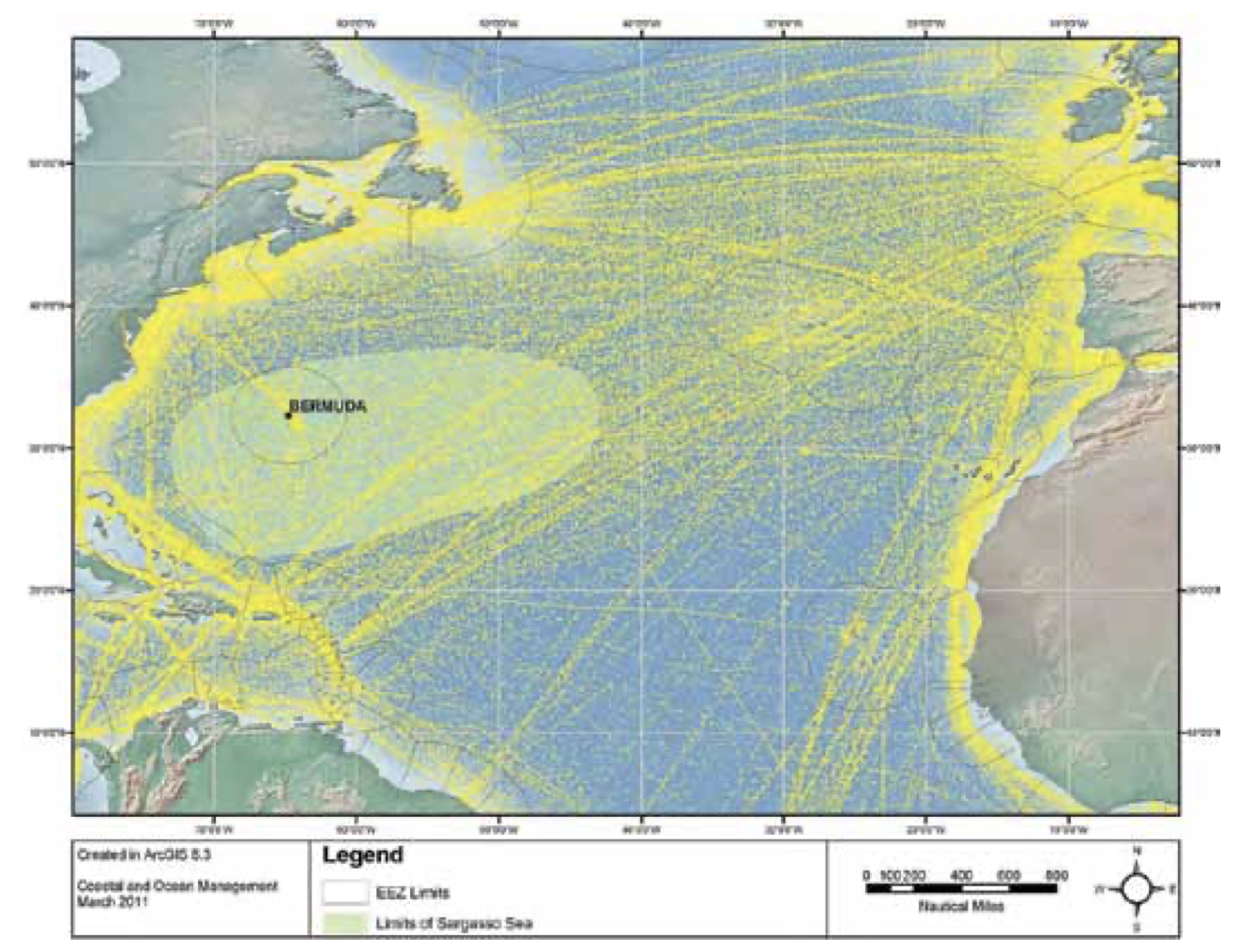
Voluntary Observing Ship (VOS) Program Data of 4500 Vessels in 2010/Roberts 2011
The absence of attention from this floating mass in open ocean waters, extending halfway into the Atlantic, the loosely bounded sea gained its name from millions of tons of floating sargassum, a rich and curious assemblage of animal life it fosters, challenging our abilities to map. It stands apart from the flow of any freshwater stream or demarcated edges and fixed bounds or shores; hardly a single polygon, the floating surface of brown algae are borne, the argued, by the Gulf Stream, that offers homes to crabs, shrimp, small fishes, sea slugs, edible roofs for sea turtles, or feeding grounds for laying larvae or webs or for flying fish and sea snakes to hide their eggs.
Like a new world lying in the middle of an ocean, a “weedy jungle” as Carson put it, a mobile “life raft” for others, it is a shelter for many to forage for food far below, and challenges our notion of surface, edge, or indeed ecological niche. The sargassum fields were either torn apart from the shore of Florida, or Caribbean land masses, or merely float rootlessly in open sea, fragmenting and enduring for up to centuries until they drift into less warmer or propitious areas of ocean, a tangled web of seaweed that lives off the land, a superfeeder site of marine habitat.

Mapped something like the fertile inverse of the Great Pacific Garbage patch that is perhaps the prime surface-evidence of the Anthropocene, in the Sargasso Sea, an estimated ten million tons of seaweed floats unrooted, as if accumulated from distant coasts, far off of coastal waters, pulled in by oceanic currents, is hard to capture as a polygon. The site of the adventure stories of William Hope Hodgson, of vessels trapped in the sea’s flowing mass, a “cemetery of oceans,” prefiguring the Bermuda Triangle, where ships are attacked by underwater creatures, fearing the “thing in the weeds” in the “tideless sea”, its vitality reimagined as a site of danger, hiding marine monsters and sea demons within its weeds as the site of the last unknown, in pre-war adventure stories with a bit of H.G. Wells and Jules Verne, conjuring canny myths monsters emerging from its deeps.

And, although once avoided by ships, there seems evidence that despite some loose protection of the sargassum rafts in international laws of sea, the propellers of large transatlantic ships slicing the algal mats with increased regularity, with little protection accorded to the sea as a space to avoid, threatening to degrade the integrity of this delicate floating tan raft. The once-continuous floating rain forest is increasingly exposed to anthropogenic underwater noise from shipping traffic, difficult to quantify or map, but considered deeply disruptive to marine life.
As the Sargasso Sea has become a concentration of pollutants and plastics, sargassum has recently grown so dense since 2011 that images of abundance and fertility are replaced by fears of harmful algal blooms, from which marine life in the coastal oceans have increasingly suffered. The flow of plastics into the seas suggest an incursion of particulate matter difficult to map in detail, but raises the prospect of trying to disentangle the line, brittle pellets, already of some 3500 pieces per sq km, in the western Sargasso Sea, back in 1972, regularly ingested by fishes and microorganisms from radiolarians to diatoms, as well as pelagics, that as they depolymerize have made the algae pioneers of a plastisphere, that new marine entity of the Anthropocene, lying just within the Gulf Stream.
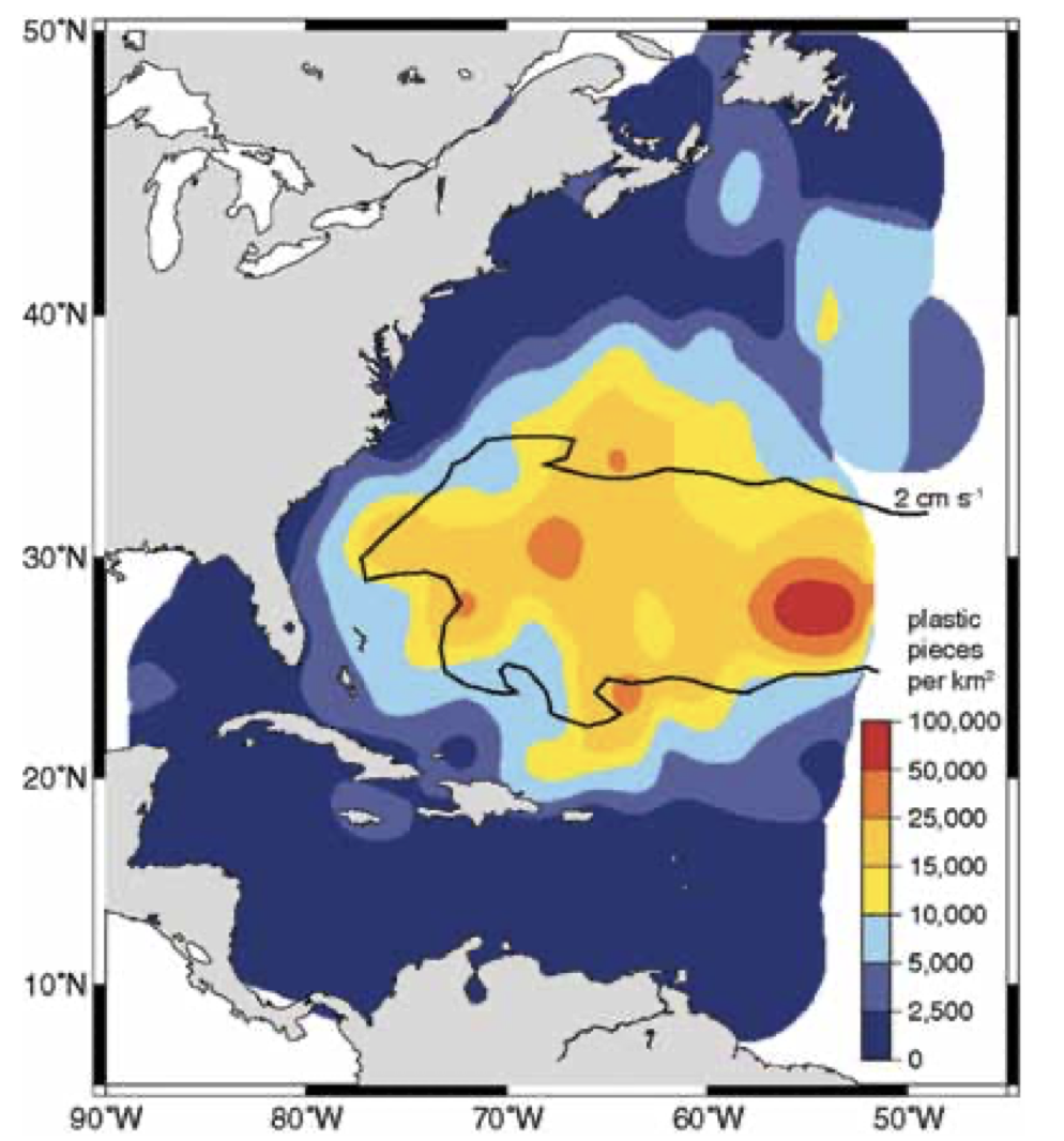
Density of Plastic per sq km in Atlantic Ocean/2010
3. The abundant feeding grounds at a remove from coastal oceans have converted, in the remotely sensed mapsworthy of globalization and climate change, to a brown opacity charting the unwanted arrival of malodorous seaweed to clot the pristine sandy shorelines of the tropical Atlantic. Fears of over-accumulation and decomposition of rank sargassum along the coasts seems akin to the garbage of global warming, anthropogenic only by extension from living in a warming ocean. Its mass has become a nuisance and a danger to human health, if not ecosystems of the coastal ocean. The danger of these unwanted algae on our shores is something that Floridians are increasingly wrestling, feeling more than ever inconvenienced by international law that forbids the extermination of this broad edgeless mass.
The bloating of the sargassum belt to some 13 tones of floating kelp is larger this March than in any previous year on record. If the sargassum belt had already grown some 1,000% in size from 2011 by 2018, the bulk of its biomass has continued to grow each subsequent year, as it grew as long as the coastline of Brazil. Satellite registrations have tracked the sequential yearly growth of the belt’s floating mass, not as a feature of hidden fertility, but a massive seaweed bloom whose “load” is greater than in recent memory, even as it ominously threatens to arrive on our coastal shores. NASA’s tracks by remote sensing tools track the density of sargassum as it floats in a Great Atlantic Belt form earth observations of MODIS via satellite, as if unwanted visitors approaching the Americas, fed by the isequilibria of warming ocean temperature —
“Great Atlantic Sargassum Belt”/NASA Earth Observatory
–and tracks its abundant density as a dark brown opacity, rather than a form of life. We may find ourselves frustrated by the inability given international conventions against capturing or culling the seaweed/algae as it approaches on open seas; the floating rain forest is protected as a habitat for endangered species, from sea turtles to multiple species of Atlantic eels who regularly return to its nourishing labyrinths, and its arrival in international waters–as if it was the latest casualty of globalization, unable to be stopped at our territorial waters!

Why so much loosely floating seaweed is carried by the oceanic currents seems in part to do with oceanic warming, the very warming that has multiplied the blooms of toxic coastal algal blooms. This is not a new manifestation of the “wide Sargasso Sea” long seen as a site of marvel, and enduring ecosystem, if the Sargasso Sea is hardly protected in international waters, its surface cut by the marine traffic that, unlike caravels, rent as the intensity and the speed of ships increased markedly in the post-war era from the 1950s to 1970s, feeding a global market of trade, before the arrival of micro plastics and anthropogenic detritus–and a disturbing accumulation of a plastisphereacross much of the more pristine waters of the Atlantic.
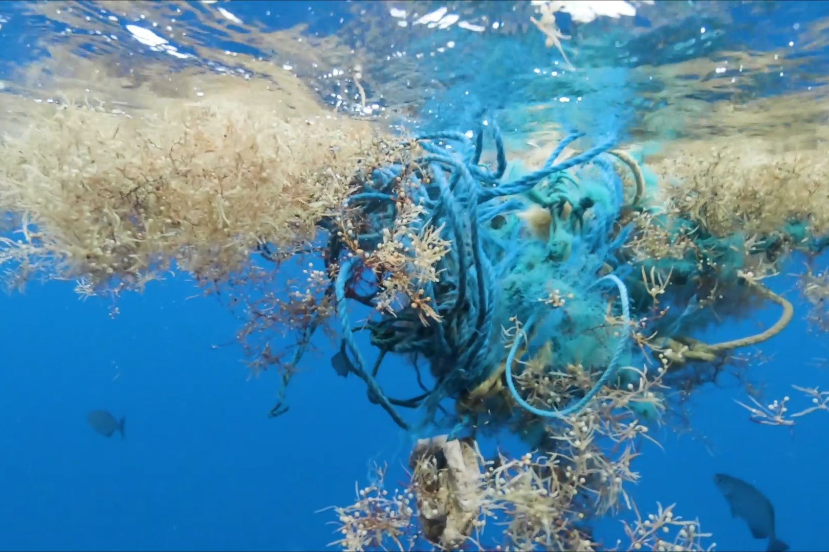
The intermingling of sargassum with plastics compromised its sensitive habitat, if not the wealth of nourishment and shelter that the marine sea forest has historically offered fishes, pelagics and other creatures. Carson speculated that the status of the Sargasso Sea may have been ripped by marine currents from shores, but what if Carson had it wrong? What if the swirling sea were fed by minerals that entered the rich coastal ocean, carried by the gyres into the mid-Atlantic, and feeding a swirling biomass? Have we been unintentionally injecting not only plastics into the Sargasso Sea, but fertilizer (phosphorous and nitrogen) into the coastal ocean, providing an overly nutrient-rich solution for the microalgae?
While Carson imagined the seaweed to have collected in the gyre, having departed the coastal environments she knew so well, the peculiar agglomeration of floating weeds, a gyre offering needed nourishment for beings from bacteria to pelagic eels and whales. But the gyre was itself nourished by waves of sediment, deposited from rivers as the Amazon into an offshore habitat.
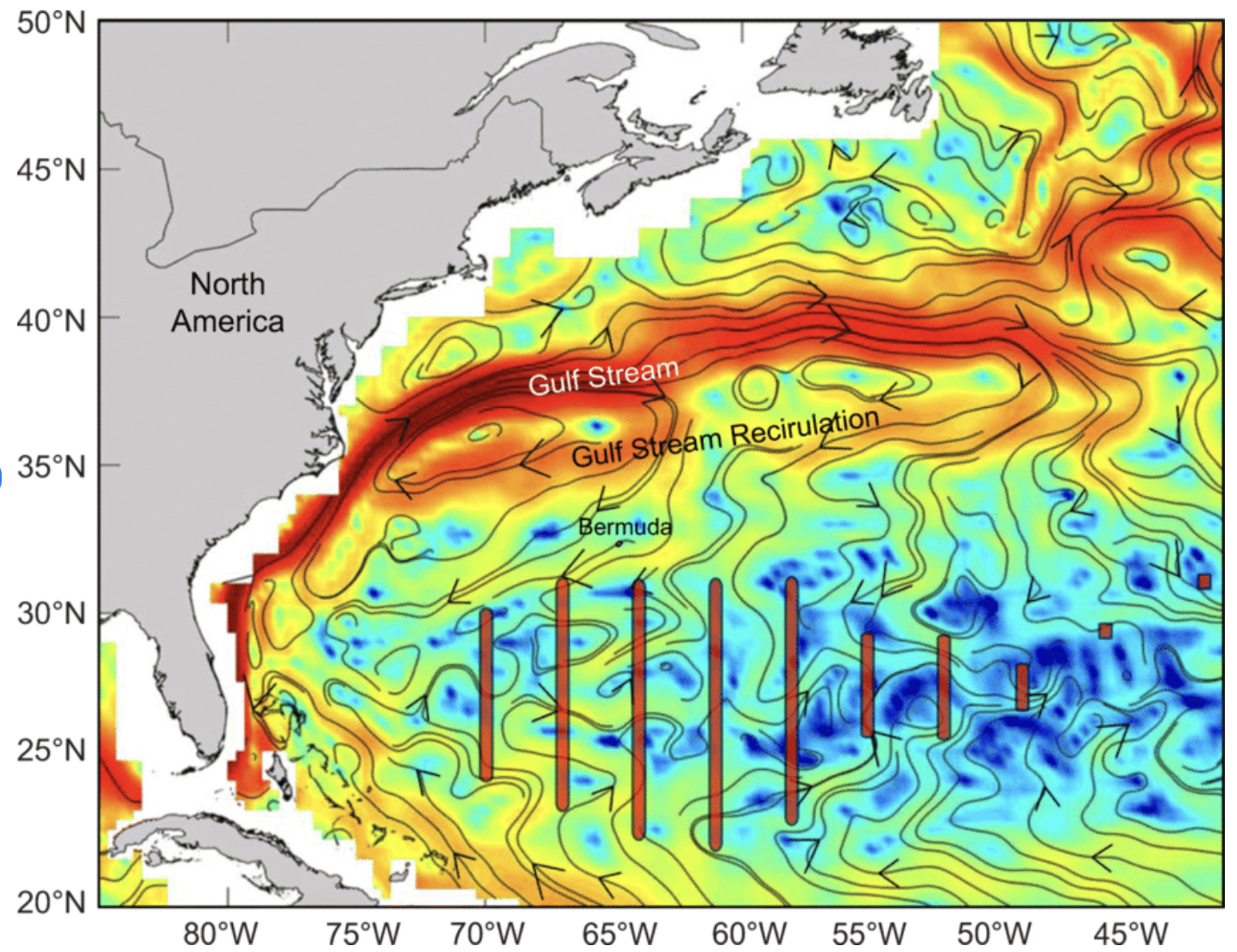
The belt of sargassum floating across the Atlantic are unlike the Sea, nestled between the Gulf Stream and Equatorial Current, and lying safely offshore. Recent concern has grown around the question of whether the Sargasso Sea has been itself violated, ripped apart as coherent mats of habitat to a floating biomass of less fertile spawning or feeding ground, nestled between the recirculation of the Gulf Stream. Larger mats of sargassum appeared across the Atlantic ocean, spanning from West Africa to the Caribbean, as a “belt” from 2011, fed by nutrient-rich agrarian runoff, as much as warming waters, in the manner of those harmful algal blooms we have heard about ten years ago, as they showed up in remotely sensed maps and on our shores. For all the hullabaloo about the impending arrival of sargassum in the Great Pacific Belt, the appearance of blooms has become so common a public health risk of our coasts the EPA runs a dedicated line to report HAB’s in many state. In our new age of increased environmental anxiety, HAB’s are feared to harm water–not to mention how to protect your dogs from the toxic waters–in a health risk, and the health risk of Sargassum is indeed all too familiar, if of far greater proportions and biomass.
Is this not due to the change of the mineral-rich waters, now supersaturated by fertilizer pumped into the ground in a hope to increase agrarian productivity both on the Amazon and in Amazonia–now being converted into a deforested grazing field–and West African countries that have become hubs of processing fertilizer for independent farmers, in a bid for economic independence sponsored by such international entities as the World Bank? Driven by the hopes for economic investment and boosting productivity of “small farms” in the hope of economic self-sufficiency of the global south, the multiplication of fertilizer plants in hopes to feed a growing population has led to the greatest application of nitrogen-based fertilizer globally, and an increasing use of fertilizer based on nitrogen in Brazil, that doubled 2010-20, per Our World in Data, and is off the charts. The imbalances of oceans risk feeding macroalgae across the Atlantic at far greater scale than algae ever experienced, creating an unwanted bumper crop of algae on the oceans’ surface as we boost global agriculture, with pronounced blinders at risks of accelerating global ecological change in an era of extreme storms.

4. Fears of algal blooms led to remote tracking of sargassum as it leaves international waters. Recent satellite tracking of sargassum set a new standard of measurement for mapping of the algae’s biomass that among that now threatens to dump some 13 million tons of clumps of the brown tan ashore as it makes landfall. But do we have a sense of how generated the Sargassum making landfall has been generated in its new habitat? How large is the bloom off of West Africa that seems to have set the transatlantic voyage into motion, and how abundantly is it growing in the offshore waters? (International Law about sargassum is oriented to the Sargasso Sea’s protection; an apparent obstacle in harvesting the weed as it floats in international waters. The apparent frustration of legal protections that prevent the algae from being harvested on the high seas before it arrives, despite its increased density and size, make it hard to map the growth of its biomass over time, as a truly volumetric map might help provide.) Hopes to prevent the five-mile belt of sargassum from beaching have led some to propose environmentally-friendly solutions to avert off-gassing, by sinking the floating weed in deep waters.
Multiple theories have been proposed for its sudden appearance and growth outside the frame of currents: the outflow of industrial fertilizer from the Amazon river–the conversion of Amazonia, and destruction of a rainforest that historically has absorbed carbon dioxide to agricultural lands by large-scale deforestation–add unseen nutrients to the coastal waters of the Atlantic, increasing the levels of nitrogen in Caribbean waters to offer propitious conditions for expansion of a belt below the Antilles and North Equatorial current. In sharp contrast to these anthropogenic growth of a rise in the ration of nitrogen to phosphorus, driven by sewage and farm runoff, fears of ocean upwelling of minerals off the coast of west Africa may be a cause of the emergence of a flotilla of new sargassum–or arrival of sands from decertifying lands in the Sahara, spread the skeletons of ancient algae as far as the Caribbean, combined with smoke and ash, into coastal waters. While perhaps partly driven by the huge sandstorms of the Sahara that blew minerals of a Saharan Sand Layer as far as the Caribbean waters, rich in marine nutrients, in the midst of the pandemic in 2020, significantly after the first appearance of the sargassum belt ten years previous.

NASA/NOAA/Colin Seftor
–the Saharan dust clouds that reached Caribbean waters June 15-25, 2020, while they long helped to fertilize the Amazon, form part of a multi-factorial shift in the sediment richness of global waters. Th feeding of phosphorous to ocean waters of the Atlantic basin contribute to the richness of the Sargasso Sea, no doubt, but the abundance that floated westward in 2020 are not able to describe the marked growth in density of the Sargassum Belt observed 2014-18, as it became a part of the Caribbean that raised particular alarm for the ocean anomalies of warming waters, particularly intense in the Gulf of Mexico, where much of the weed reproduced floating in the Yucatan Current.
This may be another way of mapping the Sargassum Belt as a global event. Did arrival of African dust that spewed across the Atlantic during the global pandemic another world-event spread across the very areas that soon stimulate algal blooms appear of such unprecedented intensity of growth? While the dust storm was a huge meteorological event itself closely tied to planetary warming, it overlapped with the seasonal discharge of nutrients to bring stimulate unprecedented algal growth.

Godzilla Dust Storm over Atlantic, June 2-23, 2020 Aerosol Optical Thickness/ NASA Earth Observing System
If seeded with more intensity, perhaps, by the dust storms from the Sahara, the Godzilla Dust Storm able to be seen from outer space was yet another example about how land and sea are interrelated, in ways that our focus on a sense of the clear edges of land and sea fail to capture, to the extent that the flow of currents are no longer a fully self-contained system or circuit, bearing algae along the South Equatorial Current westward, in the manner we can map by clear vectors.

The challenged to mapping the size and the reasons for the appearance in consecutive seasons of the large biomass seems tied to the increase rainfall of that led to a huge increase in global surface-temperature from the pre-industrial era, and magnified the chance of massive rainfall by multiples of four or five in the Bahamas, and threefold in the Dominican Republic. Despite increased drought across South America, rainfall in Latin America grew as did intense rainfall driven by hurricanes and cyclones in wintertime, sending much fertilizer, poorly integrated in dry lands, to the coastal ocean. The belt of kelp runs below the Sea appeared as a new entity at the same time. If the macroalgae of the Sargasso Sea was once thought torn from the coastal waters of the West Indies and Florida, the size of this train of the Great Atlantic Sargassum Belt is a new strain of sargassum that threatens to wreck havoc on Floridian and Mexican shores, and throughout the Caribbean.
The evocation of an emergency has been long in coming. Only five years ago, it had astoundingly grown from earliest measurements to eleven million tons of floating kelp–the estimated size of the tangled weeds that comprise the Sea, now stretched across the Atlantic. Over some twenty years, the arrival of westward moving sargassum floats have been arriving in the Caribbean, unwanted global visitors impacted by ocean warming. While the upwelling in Africa has pointed to natural causes for newly sargassum, might one be mistakenly confusing Africa as a site of nature, not engineering? Has the dominant emergence of a focus on food security not increased the flow of nitrogen and phosphorous from subsidized agriculture not also contributed to flows of nitrogen and phosphorous, perhaps in combination with the emergence of sargassum species from the upwelling of ocean waters?
Fertilizer was subsidized by Presidential Initiatives in Nigeria since 2015, reaching the fields of some five million farmers by 2020, as other initiatives promising economic growth of agricultural sectors in led to importation of synthetic fertilizer across West Africa, leading to hopes to emend soil nutrients to expand productivity by World Bank initiatives, importing fertilizer to Dakar, Lagos, Abidjan, Port Harcourt, Lomé, and San Pedro, or in Senegal, Guinea, Côte d’Ivor, and Ghana; Côte d’Ivoire imported 525,000 metric tons from 2015, and West Africa importing and blending one and a half million MT annually by 2021, per Fertilizer Focus, creating a new addition to ocean ecosystems as an added bonus of sorts, whose impacts we may be charting as a resurgence of offshore macroalgae.

West Africa Fertilizer-Watch, May 2020

Fertilizer Logistics in West Africa/Fertilizer Focus, 2021
How much are the offshore nitrogen leaching into the coastal ocean the sources of the nourishment of such abundant sargassum yields? Whatever the mechanics, we are mapping an untold aggregation of floating mats of sargassum, dislodged from the gyre in which the Sea once lay, of a new species and vitality. The absence of clear edges–even the fuzzy bounds of Sargasso Sea–are cause for alarm, precisely because of their inability to be controlled in any offshore national space–as, for example, an oil leak–and the difficulty to combine ecological efforts across borders. The mats of sargassum poised to return to its beaches in future years, and to moor on Atlantic shores, stand to emit a noxious “sea” of offensive smells as they rapidly decay in the days after they reach the shore, releasing unhealthy sulfurs that not only mar the shores we like to imagine as pristine.
What else may have magnified the arrival of this belt? We must look for comparison–and points of needed orientation–to our own coastal oceans, and inland lakes, where algal blooms–and harmful algal blooms–have predictable been in recent news in quite alarming ways. If the increasing flow of sargassum across the ocean may be fed by the nitrogen runoff that leaves the Mississippi from farming regions that saturate coastal oceans–overloading them with nutrients to create more algal blooms. The growth of this new variety of sargassum–not present in the historic Sargasso Sea–may have, argued other oceanologists, respond to the change in oceanic currents themselves, and the deep mixing that led new nutrients to be rise from global ocean beds, feeding the migration of kelp: or did a new floating population of kelp arise, outside of the once loosely defined sector of the floating sea, floating seasonal algal blooms?
Do we need to try to map this global fear in more globally rooted terms, even as we map it as an oceanic anomaly revealed by remote sensing?
5. The possible environmental explanations for the Sargassum Belt are hard to reconcile with the immediate encounter with the prolific algal belt from 2018. The encounter of an oceanographer who studies the extent to which kelp’s intensive photosynthesis might be used to draw carbon dioxide from the air, was shocked at the meeting the large biomass. If he had conducted South Atlantic expeditions for a quarter of a century, he had never seen anything like the sudden shock of disorientation sailing into the Sargassum Belt: “one moment we were moving in the blue sea, then–BAM! It was all around the ship for tens, hundreds of meters.” remote sensing, but on the water. The algal bloom interrupted the ocean waters of unprecedented scale, as if it were indeed the Sargasso Sea being encountered for the first time, that the oceanographer only later discovered was a huge sargassum bloom monitored in satellite imagery since 2011 but has continued to explode in size.
The MODIS imagery may be, in short, as good an icon of globalization as any, from the rising runoff that has been encouraged in the name of greater agricultural productivity by the artificial enrichment of nutrients in new farmlands from West Africa to Amazonia, creating an immense biomass as a new Frankenstein in the middle of a new, warming world, where increased runoff defines the composition of coastal oceans. the acceleration from 2014 of the Sargassum Belt, while already detected in 2012, to be sure, of increasing tropical hurricanes and flooding, record levels of warming of ocean waters in the mid-Atlantic waters, and land temperatures far warmer than normal in South America and western Africa–multiplying events of extreme weather, closely tied to the increased rains brought by rising temperatures across the equatorial belt. The flash floods of 2023, and recent history of severe flooding in the Brazilian Amazon, destroying crop lands at the same time as the region is afflicted by severe drought that reduced overall river runoff, have produced increasing torrential rains and terrifying mudslides, after record rains that were the highest in Brazil’s history. Yet the essentially two-dimensional imaginary in which we map the apparent “approach” of a broadening belt of macroalgae to the shores of North and South America are perhaps less than helpful in incommensurable with our spaces of territorial governance.
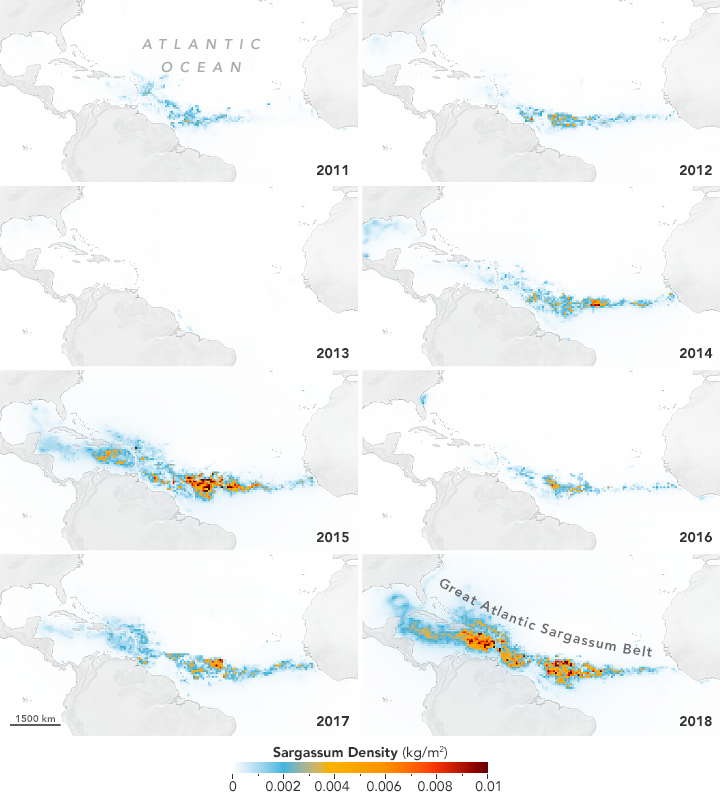
The incommensurability of our concepts of territoriality with the confluence of extreme weather events, nitrogen flows to the coastal ocean, and warming waters have frustrated existing attempts to manage such hyperbolic algal growth as the Sargassum Belt. The isolation of sargassum density by remote sensing models helps to capture the intensity of blooms, facilitated by an unprecedented expansion of marine nutrients from both runoff and severe weather. The frustration we feel before the visualizations of time-lapse maps that suggest a cumulative growth of algae–mapped from 2012-18 in ways that cannot but recall the “flat” spatialities by which migration is imagined, a model of territoriality haunted by the actual building in the same year of the border wall–have infected the manner in which we map, visualize, and understand the approach as an escalation one which we are spectators, and have no control or impact.
The prime analogue for managing macro alga is the hyperbolic algal growth in the notorious dead zones of the Gulf of Mexico. The warming waters of this bioregion, endemic with algal blooms, is not driven by accumulation of arriving sargassum. But it mirrors the nourishment the Gulf Stream offers in ambient waters of that the sargassum encounters, that allows its tangled biomass to grow dense, as oceanic and atmospheric temperatures dramatically affect the marine ecosystem. If the dimensions of these extreme elements, foreign to our actual mapping systems–the accumulation of nitrogens in agricultural runoff from attempts to emend soil in the Amazonia; torrential rains that send more synthetic nutrients into the seas; toxic blooms of rapidly reproducing floating algae–can be mapped in microcosm in our own national waters, driven by warming waters. If warming waters can retard the sargassum’s growth in part, the floods that have driven plumes of nitrogen out to sea for hundreds of kilometers–far beyond the benthic environments of the continental shelf each Spring, due both to fertilization of land and replacement of rainforest with cattle ranching. Can the oceans suffer the increased boost of nitrogen plumes into the a warming Gulf Stream?
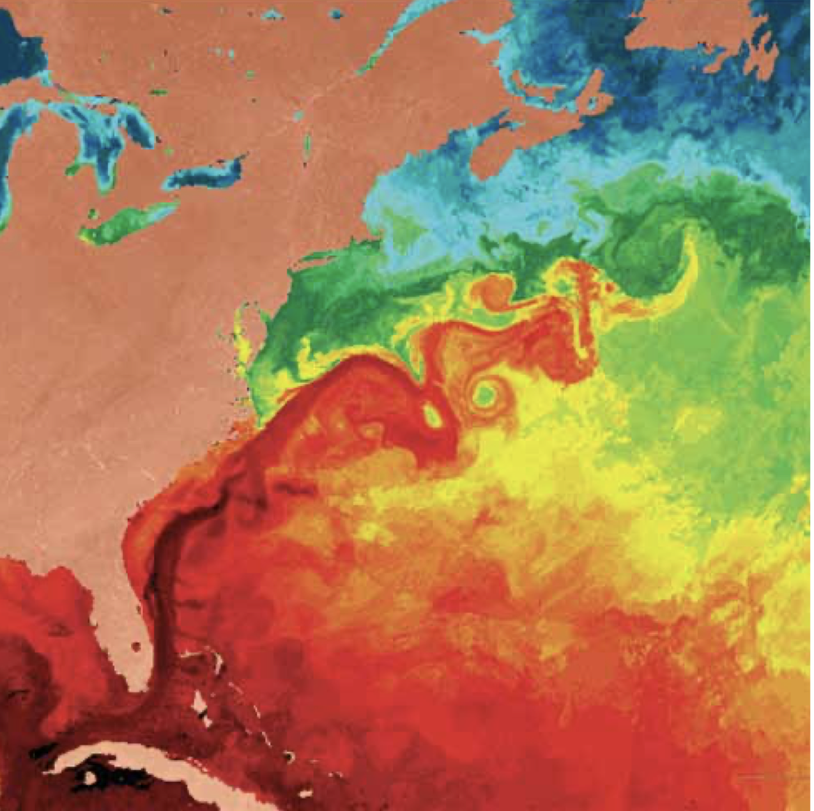
Sea Surface Temperatures of Gulf Stream/January, 2009
Warmer sea-surface temperatures in the Gulf Stream are not a false flag for the sudden blooms of macroaglae, but a context for understanding the state of the world’s largest holopelagic seaweed that we are still mapping primarily as a problem of coastal management–as if the ecological pollution derived from the seaweed arriving on our shores. We are late to map the arrival of this biomass with undue alarm, at the same time as hurricanes
To be sure, the sequestration of carbon sequestration in which plays such a disproportionate role in the global ocean; the Sea is fed by both upwelling of nutrients and warm water trapped in the North Atlantic Gyre, whose surface temperatures have been steadily rising. The floating Sargassum Belt is not rooted in the Gulf Stream or bound by it, but the path of its own transatlantic migration seems rooted in the highest sea-surface temperatures that causes its tangled webs to multiply.
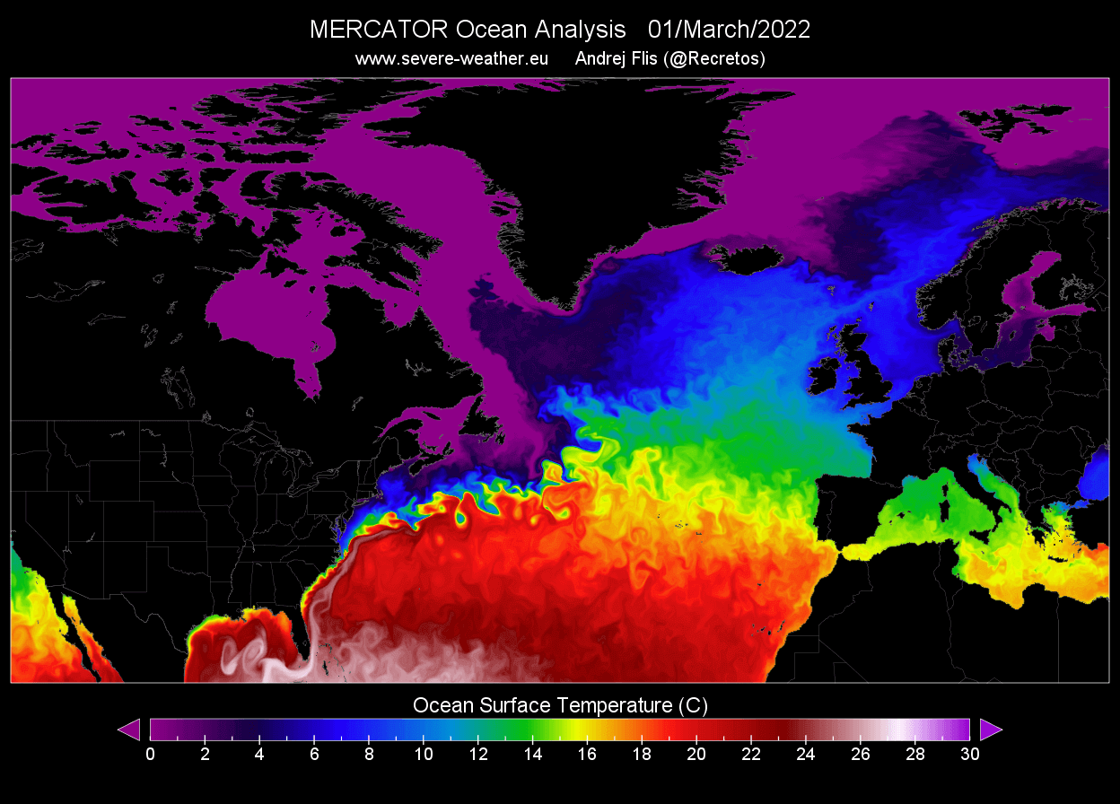
The new sargassum flourishes in regions of high sea surface temperatures, but seems fed by surface nutrients, rising to the ocean’s surface that accelerate their growth. The Atlantic Belt is an amalgam of hypermodernity, superficial floating set of plants, unlike the broad Sea that descends in a constellation of habitat some 4500 meters, offering shelter throughout its expanse to marine mammals.
The belt is far less friendly. Its arrival seems an unwanted invasion of global scale, and threatens to pollute the purity of dry, sandy beaches, that massive infertile absent ecosystem of our American shores, promoted by beach restoration, sand emendation, a site of pleasure. The sands of these beaches are often imported from islands in the Atlantic, as so many ecological engineering offering little habitat of any kind. Indeed, the absence of habitat that the belt provides–it is not being consumed, so much as reproducing in warm sunlight–is an unwanted result of experiment gone wrong: as much as a nuisance on pristine shores, the methane that will offgas from these tons of beached sargassum, removed from their oceanic habitat, will add yet another accelerator to global warming and climate change.
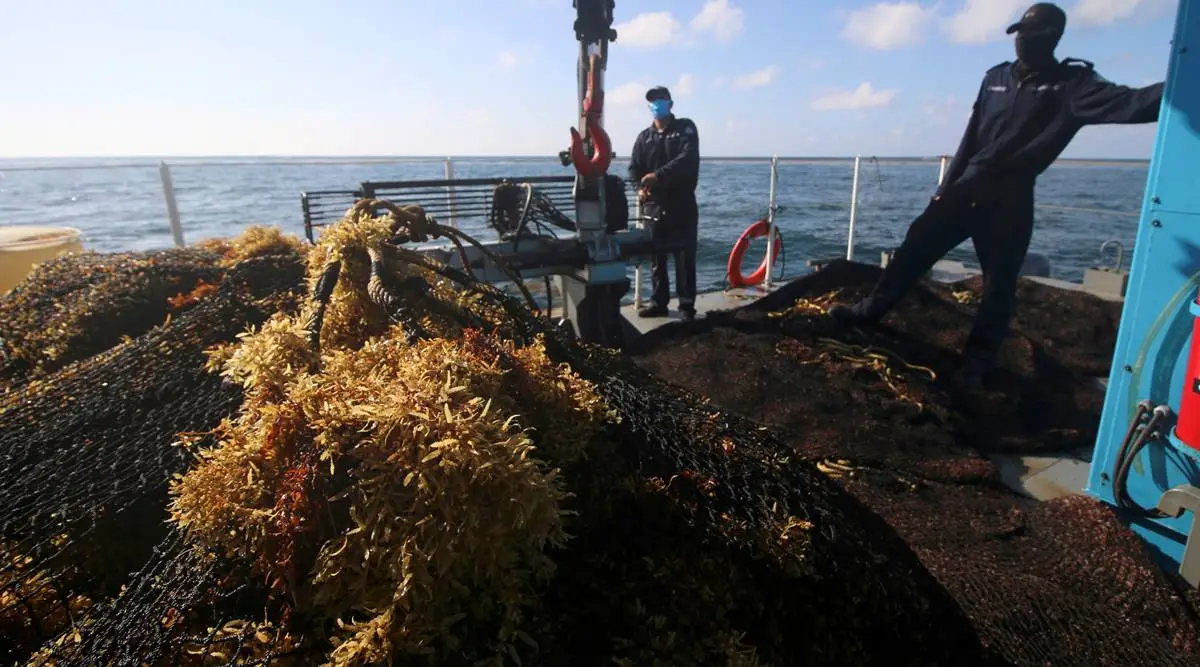
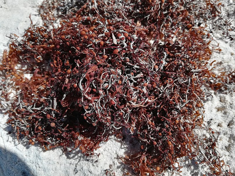
Clumps of Beached Sargassum on Crane Beach, Barbados/Clump via Creative Commons
The arrival of the stream of kelp that is ominously moving across the Atlantic is not only a threat to beach lands, but to the environment. The over-abundant kelp seems one of the many aspects of overabundance global warming has produced, but which we have studied more in the home-grown variety.
6. The growth of offshore coastal seaweeds is not the same species as Sargassum, but we are all too familiar in recent years with algal blooms. The runoff of sediment and growing nitrogen load of rivers in estuaries of our largest coastal rivers–the Mississippi, the Potomac, the Columbia River–have delivered a larger nitrogen load in their discharge in recent years, delivering seasonal discharge from coastal rivers that has changed our sense of the offshore and nearshore in ways we are only beginning to map–but are increasingly present on the ground.
The Gulf of Mexico’s massive hypoxia zone has been measured as a consequence of freshwater runoff, from the Mississippi watershed, the river discharge that nourishes algae to extract almost all the oxygen from coastal waters hypoxic zone extending nearly 6,5000 sq miles, weed nourished not only by riverborn nutrients but growing sea surface temperatures.
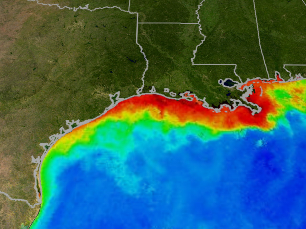
We are inclined to map increased coastal temperatures onto global warming, but are increasingly called upon to map chart the consequences of algal blooms as a danger of deoxygenated near coastal environments–altering near coastal ecosystems on which so many shore-dwellers depend–
")
But if we are much more ready to map the near-coastal in alarmist terms, perhaps this is because the national waters in which they lie have been mapped with far sensitivity, due to their proximity and integration with our economy, leading to news graphics that justly pronounce upon their danger as a sort of end of life for both fish and marine life in the nearshore coastal waters–

–and imagine the dangers of all that decomposing sargassum on the beaches, marring the deliveries of emendations of sand that try to prop up beaches as sites of economic vitality, which stand to be marred this summer by a smelly sort of return of the repressed, littering the shores with an unwanted abundance of decaying algal mats.
Before it arrives before our eyes, we have started to map its course, perhaps to try to ken the origins of all that stinky mess we have to sweep up and dispose. We’d do better to map the arrival tons of seaweed from a more global perspective, more oriented to global oceans and less guided by the landlubber’s beach shores. We would do well to do so through a truly global perspective, one encompassing Atlantic flows of kelp, even broader and wider than the truly expansive Sargasso Sea.
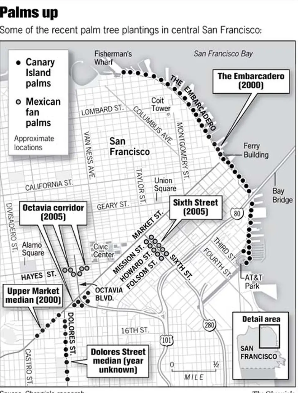

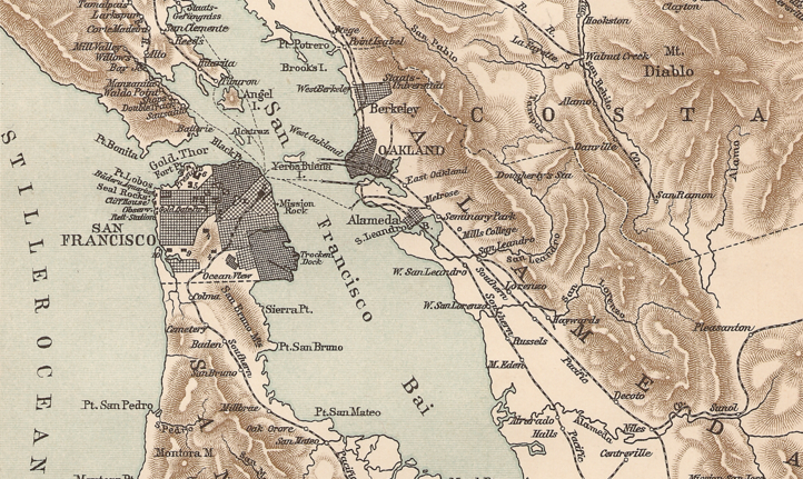


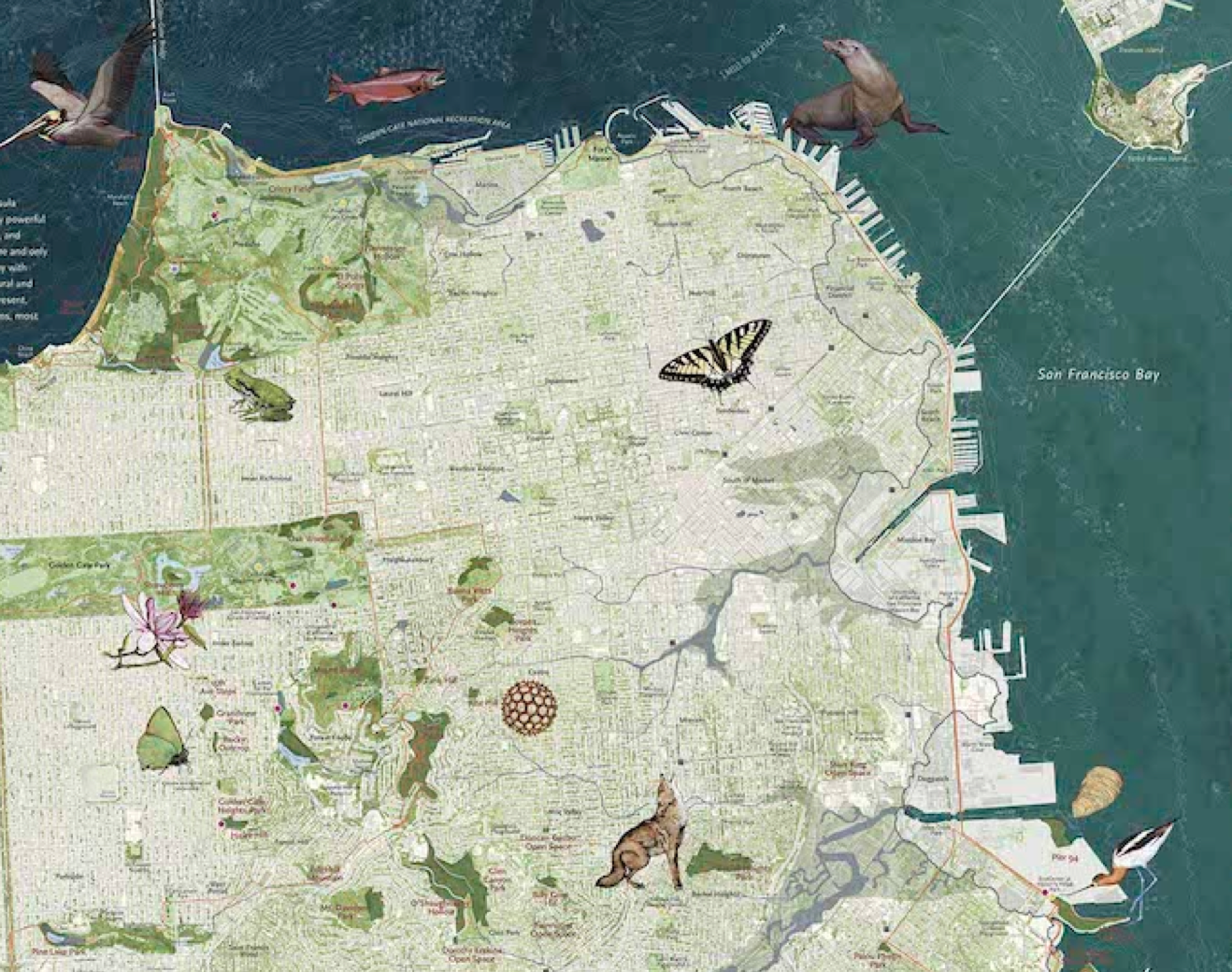


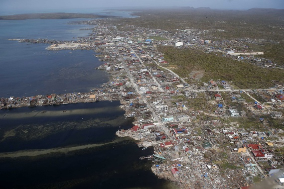
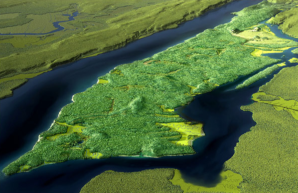

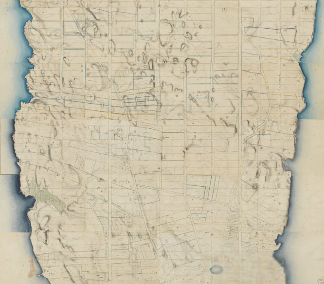

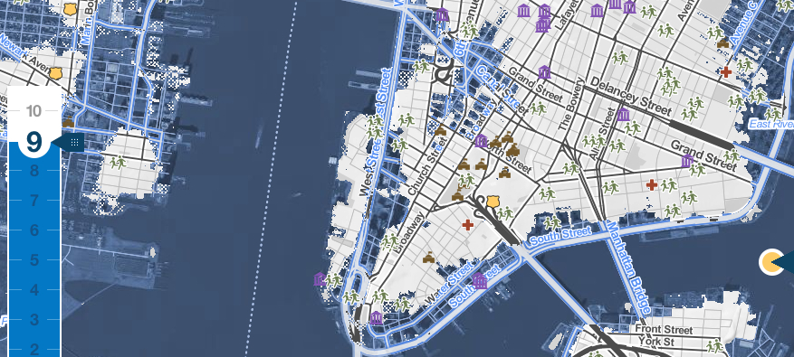

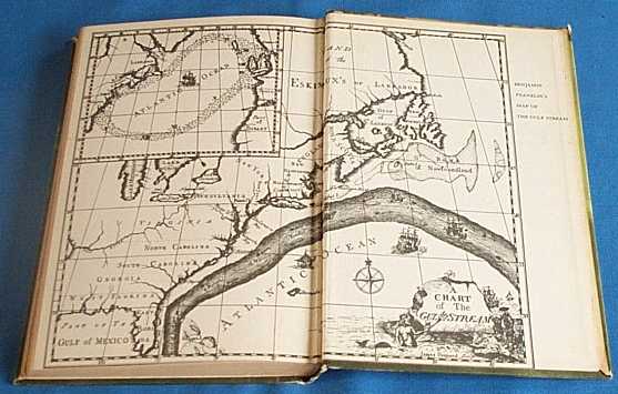

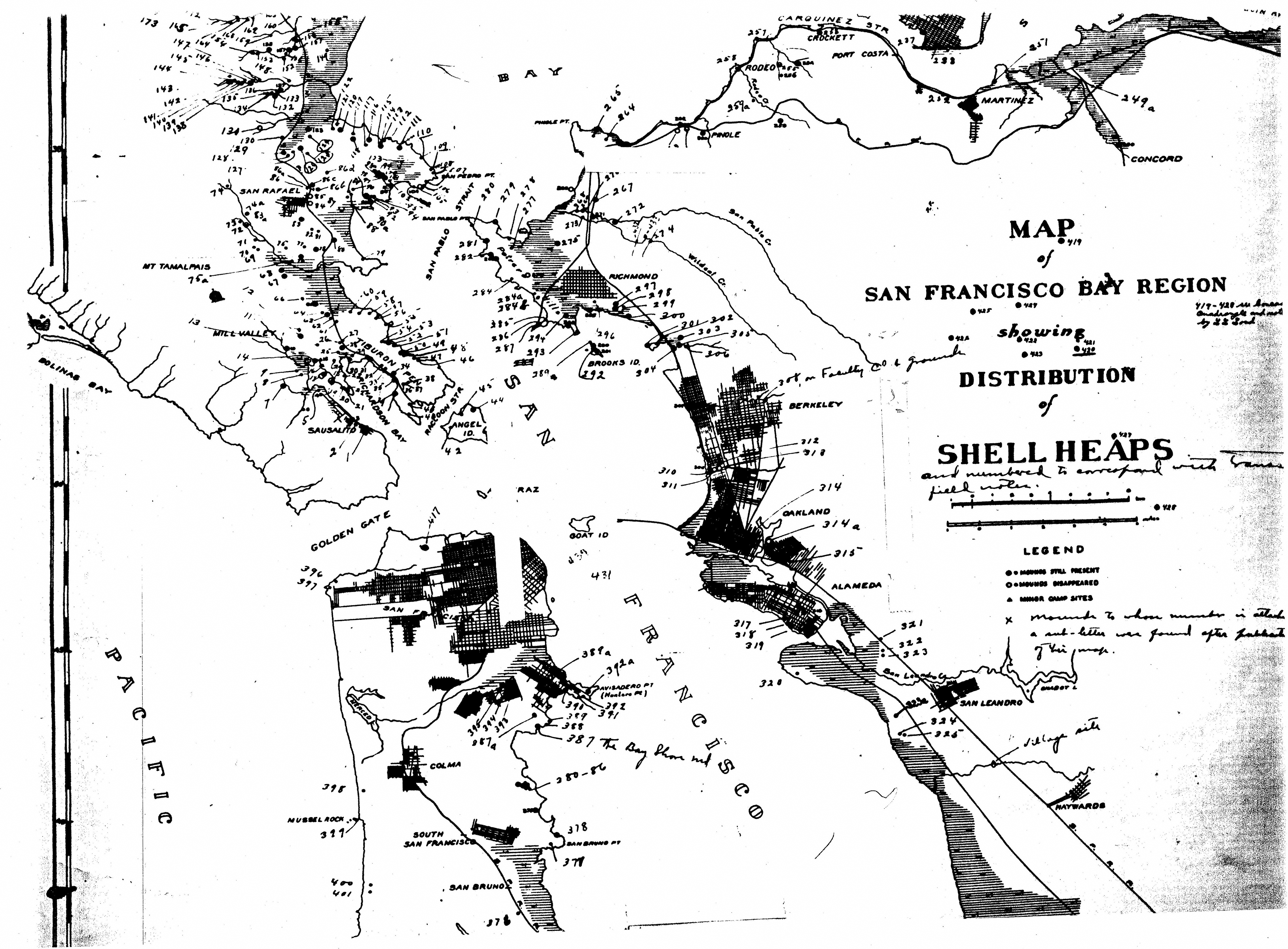

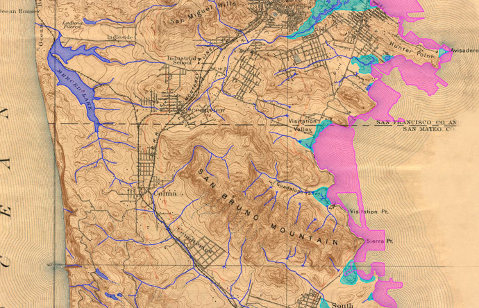

